The volcano Cumbre Vieja in the island of La Palma has been showing signs of unrest. The question on everyone’s mind is, will there be an eruption? Maybe, or maybe not. This is always hard to know.
The Spanish National Geographic Institute reports inflation, a total of 10 cm of deformation. As such it is evident that there is magma on the move under Cumbre Vieja, it has intruded underneath the volcano.
https://www.ign.es/web/ign/portal/noticias
There have been multiple swarms of earthquakes since 2017 in Cumbre Vieja, a total of nine. Previous swarms were probably magma intrusions too, but which did not reach the surface. The recent swarm however is more shallow and more intense than its predecessors which raises the possibility that the outcome may be different.
The current swarm started on September 12. A total of 4530 earthquakes have been detected at depths of mainly around 10 km, although there are a few which have been very shallow. The swarm commenced under the summit of Cumbre Vieja, where a magma conduit probably exists which is supplying the intrusion. Earthquakes have propagated to the northwest. This probably represents the propagation of magma filled fractures, possibly sills, radially from the centre of Cumbre Vieja. However the earthquakes only show a but a blur of what is going on down there. The exact shape and pathways used by the intrusions cannot really be known with much precision. It is somewhat similar to the prelude to the eruption of El Hierro in 2011 which also seems to have commenced with a sill that later propagated a crack towards the seafloor.

Image from the NASA.
The location of the earthquakes suggest a possible eruption in the NW sector of Cumbre Vieja. However there is a factor of unpredictability. The exact path that the intrusion takes may or may not connect with the surface, such being difficult to know if there will or will not be an eruption . The precise location where the intrusion will breach the surface is also difficult to know. The fissure could open in the middle of a town, in a forest, or it could open underwater, which are wildly different situations with wildly different consequences.
We can know however the style that the next eruption of Cumbre Vieja will take, whenever and wherever it happens. To do this we must look at the past history of this volcano.
La Palma
La Palma is one of the Canary Islands. It was formed due to volcanic activity. The oldest rocks of the island are 3-4 million years old and belong to a submarine volcano. These submarine lavas are now found at heights of up to 1500 meters above sea level in the Barranco de las Angustias, in the old northern part of the island, which shows the enormous uplift that the island has undergone. Probably numerous sill intrusions have pushed the volcano upwards.

La Palma. From the NASA.
La Palma is shaped like an arrowhead. The northern part is formed by the old Taburiente volcano. Deep gullies dissect the ancient lava flows exposing the overlapping layers of volcanic extrusions and the frozen dykes and sills which cut through them. The volcanic edifice was destroyed by a series of giant landslides, the last of which took place around 560,000 years ago. Activity continued inside the landslide scarp until 530,000 years ago. Afterwards activity died out in the northern half of the island.

Large scarp formed due to erosion of Taburiente volcano. Some sills and dykes are visible on the left. From Wikimedia, by Zyance.
Volcanic activity in the southern half of the island has been ongoing for at least 125,000 years and has constructed another volcano known as Cumbre Vieja, or also simply as Dorsal Sur, “Southern Ridge”. It is a shaped like a ridge in a N-S direction. Despite being different edifices it seems that Cumbre Vieja is part of Taburiente’s structure. Taburiente had 5 subtle radial rifts. This is much better appreciated in submarine shield volcanoes which are often shaped like ridges or like three to six-pointed stars. Knowing well the shape of submarine volcanoes I can see that Taburiente displays the same five-pointed star structure, although being subaerial it is not so easily visible. The longest, dominant rift goes southward, known as Cumbre Nueva. It can be seen that Cumbre Vieja is the southern continuation of Cumbre Nueva.

Topography of La Palma. Note the northern volcano Taburiente which is cut by deep gullies and a central erosional crater, and the southern volcano Cumbre Vieja which is dotted by young volcanic cones. There is a bow-shaped ridge connecting both volcanoes, this is Cumbre Nueva, the ancient rift zone of Taburiente, partly destroyed by a landslide. From maps-for-free.com.
The main magma erupted in La Palma, as well as in the Canary Islands, is basanite, which is relatively fluid, but not as much as say Hawaii. The fluidity is comparable to the more frequently active Mount Etna in Sicily. The magma is not so fluid that all of it would flow away upon landing on the surface, but it is not so viscous that it is entirely blasted into light pumice and ash carried away by the wind. The eruption style is known as “violent strombolian” or “violent hawaiian” depending on whether it produces explosions or sustained fountains. It is the middle ground between the blazing rivers of lava and the billowing columns of ash. This style is ideal for producing pyroclastic material that rains around the fountain, rapidly constructing a mountain around the vent, known as a scoria cone. These conical mounds of ejecta are everywhere over Cumbre Vieja. Because the volcano doesn’t have any central vent that erupts repeatedly, then it makes a new fissure each time it erupts. The pyroclastic material rapidly oxidices. This gives the terrain various hues ranging from black to red, which together with the abundant canarian pine trees gives the characteristic landscape of Cumbre Vieja.

Desertic volcanic landscape near the southern point of the island. San Antonio volcano visible in the centre formed in the 1677 eruption, The brighter cone to the left of San Antonio is Teneguia, which formed in 1971. From Wikimedia by Tony Hisgett.
Other magma types present in Cumbre Vieja are the tephrite and phonolite groups which are more silicic and viscous. They are present in trace amounts making small lava domes. A small volume of phonolite was emitted in 1585 producing tiny cryptodomes and domes, although the eruption was mainly basanitic.

Types of volcanic rocks depending on silica and alkali content. From Wikimedia by Woudloper.
Cumbre Vieja last erupted in 1971, 1949, 1712, 1677, 1646, and 1585. It is the most active volcano in the Canary Islands. Eruptions have taken place at intervals of 20-60 years. The exception being the remarkable 237 years long dormancy between 1712 and 1949. Why did this happen? It is possible that the volcano follows cycles of more frequent eruptions separated by long dormancies. Another possibility is that the enormous 6-year long eruption of nearby Lanzarote Island, occurring in 1730, induced a long dormancy in Cumbre Vieja.
It would not be unexpected that now, 50 years after the last eruption, there was a new one.
The eruption of 1949
The eruption that took place in 1949 is an interesting example of a typical Cumbre Vieja eruption.
Swarms of earthquakes had been frequent since 1936 and leading until the eruption. The morning of June 24 some fumes were noticed, and soon afterwards a towering black column of ash was rising hundreds of meters, if not more, into the sky. A new volcano had formed along the crest of Cumbre Vieja. The fissure had opened a small distance north of the highest point of the ridge. The vent is known as Duraznero.
During the following days Duraznero continued to erupt, belching out ash and rocks. Earthquakes frequently rocked the nearby communities and steaming fractures opened in the ground around Duraznero. Magma must have been making its way into growing fractures. Over the days the erupting fissure progressively grew to a length of 500 meters and developed 5 main vents, of which Duraznero 2, at the southern end, was the most active, creating a 170 meter-wide crater. The activity was entirely explosive but of a low intensity that must have been little more than a slight annoyance to the local population. The erupted lava was tephrite. Earthquakes were more impactful, they damaged houses, cracked roads, and occasioned rockfalls. On July 6 the ash was carried downwind over the island of Tenerife where it wrapped around the summit of El Teide in a menacing black cloud.

Fissures of Duraznero. Image by KrisNM.
On July 8 a stream of lava came out from a new location known as Llano del Banco, 3 kilometres north of Duraznero, and from the other end of a system of cracks that had opened up. It did so quietly with no explosive activity whatsoever. The lava must have been degassed by Duraznero, gone into cracks, and found an outlet at a lower elevation from Llano del Banco. The lava erupted was tephrite, same as that of the earlier phase of the eruption. The initial fissure died out at about the time the new vent opened.
It is common for eruptions of Cumbre Vieja to have some vents which are dominantly explosive while others are effusive. In the eruptions of 1646, 1677 and 1712 it also happened that the vents which opened at the highest elevations had explosive activity and built large cones of scoria, while other fissures opened at lower elevations, sometimes offrift, and even at sea level, producing solely lava flows. The eruption of 1949 shows how the process works. A vent that is high up degasses the magma and then it is carried laterally through fractures towards openings downslope from which it emerges effusively.
Lava descended in fiery tongues from Llano del Banco down the flanks of the mountain. People were being evacuated as the flow headed for populated areas. It took 10 hours for the lava to reach the main road of the south of La Palma. Later that day the flow had destroyed 20 structures, including houses, cellars, and barns.
On July 10 lava cascaded over a cliff into the ocean. From this day on the entry of lava into the sea became continuous, and a lava delta was gradually constructed. Cloud of steams rising over the waters were illuminated by the convoluted streams of incandescent rock.
A new change in the eruption took place on July 12. The composition of lava erupted from Llano del Banco changed from tephrite to basanite. It became less silicic. At a similar time a new vent opened 400 meters north of the initial vent of Duraznero in the location known as Hoyo Negro. Black cauliflowers of ash pierced with flashes of lightning rose rhythmically from the Hoyo Negro vent. It erupted various magma types including basanites, tephri-phonolites and phono-tephrites. Once again the vent uprift was explosive while the vent downrift was effusive. The basanitic magmas must have released their gas into the explosions of Hoyo Negro and then come out laterally through the opening in Llano del Banco.
Hoyo Negro projected bombs to a distance of 1 kilometre from the vent snapping the trees and setting portions of the pine forest on fire. Clouds of ash frequently dusted the western part of the island. The explosions excavated a 400-meter wide crater on sloping ground. This created a spectacular 200-metre cliff against the higher side of the slope, which exposed the many layers of ejecta painted in a variety of colours.

Hoyo Negro. Image by Rafael Medina.
A raging stream of lava continued to issue from Llano del Banco and cascade towards the coast. Despite erupting continuously for 18 days the vent produced no distinguishable ejecta, and shows how the gas had been entirely removed from the melt before erupting. The ground above the fissure collapsed among loud noises, the rocks fell into the stream and were carried away, a length of 150 meters of rock above the conduit was eroded away and disappeared leaving behind a deep chasm in the forest.
On July 22 the activity of Hoyo Negro was down to a solfatara. Llano del Banco was also dying down. By July 26 the eruption had fully stopped.
Early on the morning of July 30 the eruption suddenly resumed. Duraznero and Hoyo Negro exploded simultaneously. An hour later fluid basanite lavas emerged from the location of Duraznero 1 and poured into an old crater where it formed a lava lake which then overflowed and formed a narrow stream of lava that rapidly sped down the steep slopes of Cumbre Vieja, cutting the road of Santa Cruz de la Palma, and nearly reaching the sea after 11 hours of advance, when the eruption came to a stop. This was the last episode of the 1949 eruption.
The flow of July 30, although of rapid advance, it was fed at a rate of only 10 m3/s, which is very low. It was also similar to the mean eruption rate of Llano del Banco, which was approximately 14 m3/s. The explosive activity was of little volume so it probably does not change the overall numbers too much. As such the eruption of 1949 was of very low intensity, in both its effusive and explosive counterparts. Slow eruptions are typical of the Canary Islands. Such low intensity eruptions do not pose much of a hazard to the people, in fact no one died in the 1949 eruption, despite 120 houses or so being destroyed, and people having approached the eruption in order to view it. This doesn’t mean that the hazard is inexistent.
If someone stands very close to the vents he/she could be asphyxiated by the noxious gasses or may be impacted by a lava bomb or by lightning. Rarely when lava flows reach steep slopes they collapse into blistering landslides resembling small-scale pyroclastic flows that could potentially kill someone. Conditions around volcanic eruptions can change suddenly in unpredictable ways and become hostile to humans. Safety is not guaranteed.
If Cumbre Vieja erupts in the future it will probably resemble the 1949 eruption in many ways: an earthquake prelude to the eruption that may deal damage to structures, unpredictable opening of fissures, some vents producing mainly explosive activity while others feeding mainly streams of lava that destroy human properties, and also the likely entry of lava into the sea.
Of course if the current earthquake swarm will culminate in an eruption or not cannot be known for sure. Swarms before the 1949 eruption occurred as early as 1936 and did not culminate in eruption until 13 years later.

San Martin volcano, formed in a 1646 eruption. Image by Rafael Medina.
Interesting links
Eruption of 1949 (in spanish).
GRAFCAN visor (includes geologic and topographic maps).


.jpg)
look at the speed and force of the ejected material.
https://twitter.com/IPNA_CSIC/status/1440782743890055169?s=20
facinating!
There is a new lava flow going South.
https://www.eltime.es/isla-bonita/35476-el-volcan-recarga-la-colada-sur-y-empieza-a-bajar-otro-monstruo.html?fbclid=IwAR0t9vfUjyecqKPHi3EinX-eAN-UP6TkgFMfc06NSoHO2HXXIiHVUhIPWMM
Part Translated
”Thus, the slowness of the main lava tongue is already known, quantified in the last hours at 4 meters per hour, which has already definitively entered Todoque, where it also maintains its pause in front of the church, after eating several buildings.
The bad news may be that the large amount of material emanating from the mountain is causing the tongue to expand to the sides, affecting more properties.
But now another concern is added, a second wash further south. This one, which surrounds the Rajada Mountain, advances faster and was initially heading towards the Las Manchas cemetery, although its uncertain trajectory seems to change.
In this image taken by ElTime.es it can be seen how at the beginning of the night of this Wednesday, September 22, he was already approaching the houses on the north side of the mountain with a huge incandescent wall.
In that area it already “attacks” groups of houses in its path, as can be seen in recent images.
Regarding this second language of lava, the circumstance that it approaches and overlaps the eruption of the San Juan Volcano in 1949 was considered. Although at the last minute it seemed somewhat unlikely. It is for now an unknown.
It advances without anything to stop it with a front several meters high, and with a certain speed.”
https://www.eltime.es/isla-bonita/35476-el-volcan-recarga-la-colada-sur-y-empieza-a-bajar-otro-monstruo.html?fbclid=IwAR0t9vfUjyecqKPHi3EinX-eAN-UP6TkgFMfc06NSoHO2HXXIiHVUhIPWMM
There was always a second stream, from the beginning, that went south of Montana Rajada. It might be that that one is advancing faster.
As far as I can see that map is not accurate. So far I’ve never heard of a fissure on the LP-212 street. Is that correct? Something is wrong here. Also compare with OSM and Copernicus.
Spectacular footage of the lava fountain.
https://twitter.com/i/status/1440782743890055169
La Palma has just been on a live feed on UK ITV on Good Morning Britain the man from La Palma also confirmed there is a new flow going South unbelievable nothing from Pevolca or the Cabildo.
Here we have a difference between iceland and the rest of the world. Its why the get more and better coverage for their eruptions.
They have regular reports by their volcanics team in icelandic AND english. Its just a fact that english is the de facto lingua franca.
They have cameras set up for general viewing 24/7, even if just stills every 10 mins or so.
Their TV have clearly realised its good for iceland’s tourism to have several webcams of the eruption even if its isolated location means its very expensive to do it (unlike here where there is easy internet and electricity and access). They may be subsidised by govt.
Some local people give consistent, routine and reliable reports on youtube, again despite a LONG hike to get to the site.
Spain (and Italy) seem more chaotic, possibly remembering the Italian vulcanologists who went to jail. We used to get authoritative reports about Etna, but nowadays (again) the limited information results in limited comments.
How can the lava flow be heading south (except very briefly), in terrain that slopes to the west?
My hunch is that this is more likely due to media error than the lava disregarding gravity. 🙂
A more serious guess is it’s a translation issue; “south of the other flows” became “going south”.
Its not media hype its been confirmed by a geologist the link below is authenticated by CopernicusEMS
https://pbs.twimg.com/media/E_3yYBDVUBAHGYQ?format=jpg&name=small
You are right (as far as I know) in that the early (Sep, 19th) southern lava stream flowed around the Mt. Rajada on the northern side, i.e. it turned right (and destroyded the chimney house, btw.).
Then yesterday there was a new attempt to the southern flank of the Mountain. This is what is called the ‘new’ stream I guess. Can we agree on that?
Do you know what the large round blank spot is which is in between the lava front and the sea in the middle of the town?
That’s a cone, a mountain (Mt. Todoque). Like many others in the area.
Thanks Quinauberon. I need to look at the landscape properly.
In regards to Jan’s comment- it’s just perhaps the current lava flow had an off shoot that diverted south direction – it’s a guess but possible.
Oh yes, but in the end it will head for the Ocean in the end.
I have just added the link which shows the new lava flow going in a southwards direction I think it could be following the path of the 1949 eruption.
https://pbs.twimg.com/media/E_3yYBDVUBAHGYQ?format=jpg&name=small
Early on there were two lava streams. One in the north that was captures by the early helicopter video (two houses swallowed), and a southern stream that reached houses east(!) of the LP-212 street. This second stream is not new. It passed the Mountain to the South and is now advancing. Be aware that north is to the left in the following picture.
Is there any evidence of yet another third stream? (please not a tweet and not from TV copying from a tweet, or TV copied from TV that copied from a tweet, or a tweet that quotes TV that copied from a tweet, or …)
And I’m also interested in evidence for the media claim that the lava stream is expanding to the sides (north and south).
To flow to the north and south, once it has left the general area of the vents, it would have to flow uphill. It is also uphill towards the cemetery. The flow doesn’t seem to be strong enough for that. I’ve just followed the contour lines to the roundabout in Todoque, using the map below and it closely matches the extent in your image, with an extension from the south flow to the north, eventually joining, before it is likely to flow anywhere else.
http://www.ign.es/iberpix/visor/
This map is quite detailed, with 10m contours and quite a few named features (for example, the area of the vents is namesd Las Plantas and the two volcanoes surrounded by the flow are Montana Rajada to the east and Montana Cogote to the west.
This video shows how much ashfall there is they are clearing some roads with a sand plough. .
https://twitter.com/i/status/1440767585574735874
Is the lava fountains still going from the vent?
Volcano is still inflating?
https://twitter.com/involcan/status/1440941822939996160
The height of the volcanic plume has been estimated at 4.2 km above the eruptive mouth
https://twitter.com/RTVCes/status/1440954614401179649
Evolution of past eruptions
Regarding the collapse of the green house at the roundabout: Surely you can have your own opinion on that, but honestly, if I watch that video first thing that comes into my mind is “wow, that is quite spectacular!”.
Not beautiful of course, but spectacular nonetheless, as is some of the other footage from La Palma.
And yes I would have had rather different feelings if there would have been people’s lives in danger, if I would have watched at all.
But thankfully the lava seems to have been rather slow, with plenty of time to flee.
Comments from Adriano Nobile
‘I am a research scientist in KAUST. I process radar images to study ground deformation. I like to see colorful fringes on my screen.’
(Sep.16-22). A complex deformation pattern: two lobes of range decrease (uplift – red areas), two areas in range increase (subsidence – blue). The orange area indicates the lava flow. I would say that it is a dike intrusion.
https://pbs.twimg.com/media/E_4zoKYVUAoTx01?format=jpg&name=900×900
This matches the very recent and significant movement of LP03 to the south.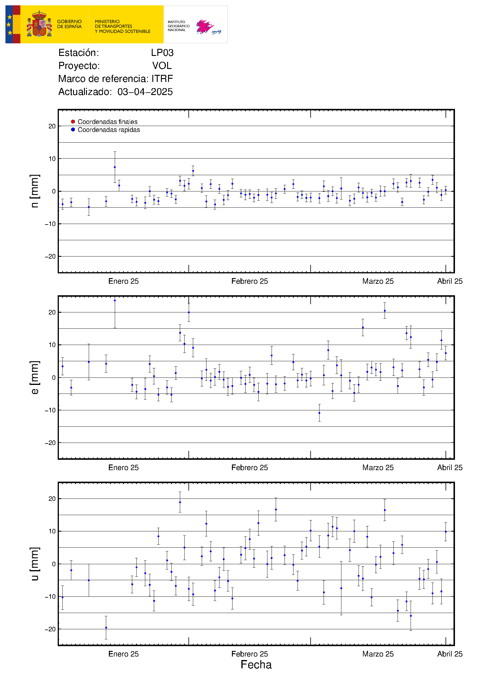
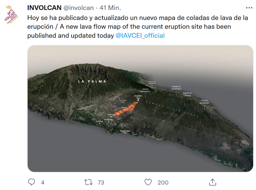
The perimeter affected by the lava flows #ErupcionenLaPalma amounts to 10.47 km
📍 Magma moves at just 4 meters / hour
📍 #Pevolca doubt that it reaches the sea
📍 Deformation of the terrain is maintained at 28 centimeters
I noticed on the Borgafjell still camera (over Natthagakriki) this morning that lava is still flowing into Natthagi from Geldingadalir. Quite interesting that it is still moving around.
The only thing I see are two or three glowing points. They’ve been in the same place for days. Starlight?
The only picture I saw from Todoque from this morning is from a video in YT (there are 59871 videos showing pictures from yesterday and claiming to be recent). Seems like the lava progressed only a few meters and has reached the buliding under construction. It will then either stop or continue down to the free space below that building and along the street directly south of the church hill. As planned.
Why is this from today? The sun glimpses through the ash/clouds from the west.
Sorry, here is the source: youtube…/watch?v=04Jb4wm6W0g. Not clear if this is actually the SOURCE or this is just stolen from somewhere.
Correction: Sun shines from the EAST, of course.
Thanks for seeping through all those videos, I have given up with so many fakes and reuploads…
This page has become my “news source” now hahah
Live feed of a moving lava flow sorry do not know which one.
https://youtu.be/sFEZACRRJBk
In fact it looks like there is more that one.
It is the new “southern” flow lobe. You can see it running inside the older cone.
So much dark matter spewing out now.
https://youtu.be/qtsA-30_OQU
Impressive now!
I hope the person who made the Todoque videos with the drone yesterday will repeat it today. No GutnTog quality, but the best we had. The channel is new and the various videos are shown in full length. Not just short clips.
I also don’t understand why no central authority issues up-to-date information and maps. Every institute gives a few treats. Some information is only given in interviews and everything is in spanish, so you have to fall back on formats in eglish.
It’s not the first volcanic eruption on the island. It all seems uncoordinated.
He did already: YT…/watch?v=aTMbhDeRy9s
Looks like the lava streams (northern and southern) almost reunited now – at least there is steam coming from inbetween them. The southern lava stream, that ran south of the cone A seems to pass north of the second cone B. That would be very good because the cemetery is just south of the cone B. This is however not completely clear yet.
Doubtful if the owner of the drone (Antonio) is able to continue this service. Information below the last three videos:
“The police have just expropriated my gift, they do not understand that it is to help in this misfortune. They suggest that the person who wants to know the situation of their home has to go through official means …..
I have uploaded the videos that I had in cache that is why the resolution is so bad.
I don’t know if I can get the drone back.
I encourage everyone !!!”
I hope he gets the drone back. Someone felt very important and I don’t mean Antonio.
Just to complete the story: The cemetary on the very r.h.s. is untouched (thumbs up). Lava from the southern branch passes the cone B to the north and seems reunited with the northern lava stream.
Source: YT…/watch?v=3FBF8XsU1MU
Its spain, organization is heresy!!
Agreed the lack of up to date info is having people and even media “relying” on social media which is full of fakes and megatsudoku disinformation
Probably also lack of experience whith this type ofsituations as tjey happen with very low frequency… lets hope they learn and improve
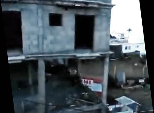
A fire fighter made a video most likely from the rooftop of the pink building, showing that there is lava already in the unfinished building opposite the street.
From this video:
https://twitter.com/RTVCes/status/1440998406806196232
I think there are a new fissure opening to the left of the main vent… i see it on live stream
Could be two, looking at the RTVC feed. The smoke from these areas is the same colour as the mini vent we have seen on the camera side of the main vent which is a indicator for sure. It could be wildfires caused by hot ejecta though. The wind looks to be blowing in that direction. However, they are in the line of a proposed rift (earlier post) so I’m not sure either way!
We wait to see – nightfall will help, if there’s lava about.
Its the new “southern” flow front work. Not a new vent from what I have observed.
Thank’s!
The two ringed areas to the left which are above/behind the main vent. The earlier smoky vent is ringed to the right.
Yes that’s what i saw and thought it was new venting starting
Someone called Barbara posted a link to some drone footage which also shows the possible vent.
Here is a screenshot – the upper ring is the new white smoke area
Here’s the YT link – visible from about 2 minutes in
https://youtu.be/3FBF8XsU1MU
Charly91 when Kilauea there was no web cam for weeks. It was left for private citizens to stream it from a house of their friends that were luckily on the high ground. Its good we have webcam, but i agree on the ground stuff could be better.
Similar views at both locations this morning.

Ha ha!
2.6 mbLg
NE FUENCALIENTE DE LA PALMA.IL
2021/09/23 12:07:51
13
13Km… more magma to feed the sistem
There is something seriously in disorder. The net continuously reports a new fissure. And there is even a concrete location given: Tacande a few km north of the vents. Even Volcanodiscovery.com reports it. Also some serious persons. As far as I can see there is no new fissure near Tacande whatsoever. So is this just completely made up?
Volcanodiscovery: “The eruption is now concentrated on the new fissure near Tacande that opened yesterday.
This morning, we could see tall lava fountains continuing from it as well as a new lava flow that reached approx. 1-2 km length in the area between Tacande and La Laguna.”
https://www.volcanodiscovery.com/de/la-palma/news/142245/La-Palma-volcano-update-New-vent-near-Tacande-remains-very-active-with-lava-fountains-and-active-lav.html
Would they make all these details up? Is it april 1st? Are we all focussing on one eruption while there is another one going on? What is reality?
That is the fakiest fake in the history of fakery.
Fruitful days for philosophers. Is there even a difference between what is real and what could be real and is treated by millions as if it was real. A lava flow from Tacande down to La Laguna is not that different from the real one, is it? It could exist. It doesn’t, but it is treated the same by most people. The world is everything that is the case. Also, my coffee is cold by now.
Seriously now. You can’t think that their priorities are satisfying the vicarious needs of the world’s population of curious on-lookers or tourists who might ‘amp’ their economy, volcano geeks or skilled and educated science types, by providing these with accurate and up-to-date information. If ‘the dragons’ and others of their ilk were part of an organized standby team and service who would have a dog in the fight to their benefit, the information might flow in an accurate and timely fashion, We’re looking over their shoulders at the progressive destruction of part of the island’s infrastructure which is their only concern. Where this company gets the data to plot the course is the last of theirs. In that regard, it would be interesting to know what was in the mind of the police officer who confiscated the drone. Might it be that he assumed the owner would be profiteering from the misfortunes of others, and it pissed him off? I’m keenly aware that plethora of video which flowed from Iceland did not do so for purely altruistic reasons. Nor did the idiot tourists who hogged the camera’s view have any concerns for the visual needs of this august body. They just wanted to be seen. Such is the nature of the human condition.
@ZZDoc. Human nature was always the least thing I was interested in. Whenever people behave against that nature, there is a sparkle.
Aside from this: I found it just notable that we enter an era where the difference between real and just possible becomes more and more blurred. If a fake matter is spread by the social media, it becomes more and more real. And the viewers don’t care at all. Because they can’t feel a difference, there is no difference. If in science there were two contradicting theories, scientists wouldn’t stop until the contradiction was solved, one theory, the more plausible (called ‘true’) survived. Now, with the millions liking fake stuff, contradicting realities just run parallel. They become alternative facts.
— Yes, I’ll calm down. And yes, that’s not too original, but I essentially wasn’t faced with Twitter and so forth until now.
You could believe that your coffee is warm again? Or you could use the microwave if you prefer the facts to be real.
I have found the search engines complicit in this too. They actually do control what people are allowed to know. When I went looking for LP03, that’s when I discovered that data on the internet is scarce and throttled. The constant repetition of mega-tsunami videos in regard to this very mild eruption makes me wonder if some are being paid to keep up the stream of fear, it seems almost incessant. Some meteorologist talked about hot lava reacting with the salt in sea water, and the next thing I know, we have acid rain falling down on La Palma and dissolving it all away according to the thousand-times repeated social media posts. I am sure that the meteorologist was only thinking of a mild production, but it got changed into a planet catastrophe. Even Volcano Discovery gets pulled into repeating junk “facts” such as new vent openings.
I am not sure what the solution is?
We are in “If a tree falls in a forest and lands on a mime, does anybody care?” territory.
The beast is up the hill. We would see it if new. Its the new “southern” lobe. Was brutal business today that vent.
Mosaic. I know that there is no new vent in Tacande. The point is: They even make up a whole story, with lava streams reaching La Laguna. Which is just a fairy tale. No need to say that the ‘new vent’ video from 19th is still circulating.
its crazy if the same amount of lava would have been spewed out than the amount of bs some people are posting on social networks the flow would have reached the ocean long ago.
I guess its better to wait for official sources even if they afe painfully slow
New Livestream by LocalTeam: https://www.youtube.com/watch?v=CBCBM_ZCa40
“Local team” is now providing a close-up livestream from El Paso in La Palma:
Just ended…
Wow .. its making itself a competely New Cinder Cone .. a whole new mountain is being born ..
https://www.facebook.com/INVOLCAN/posts/306455441285452
Auto-translated.
My VolcanoDiscovery app reported a 9.5 earthquake in Argentina about an hour ago, while now it says “event: deleted.”
Heck of a typo. Spit out my coffee and nearly fainted.
🙂
Seriously my heart was pounding. Felt dizzy and sick.
Yikes.
So now we live in an alternate history where this earthquake didn’t happen..
….or perhaps ‘someone’ wants us to believe that it was ‘fake news’. Conspiracy theories abound these days.
*** attention: this is not real, it is made up – not promoted by VolcanoCafe ***
Just found this on YT:
Note the yellow arrow and the flag. I didn’t click on it, I couldn’t. Too weak.
#seemslegit
Latest GPS
Resumption of upwards movement or may it be caused by other things (error in measurement etc..)?
The very recent 12 cm movement south of both LP03 and LP04 is significant. More magma intruding, see the inSAR map in one of the earlier posts.
The youtube channel of Rayco Glez got two drone videos from today of the lava flow in La Palma, including a close-up of the situation at the church of Todoque:
https://www.youtube.com/channel/UCrDoWTXismE-q73ArnrRusw
https://www.youtube.com/watch?v=3FBF8XsU1MU
We don’t see any of the other vents captured in these images, particularly the main e-vent which had all the attention out of the gate and was blowing so hard through the first 24 hours.. Wonder why? Are they not in the same general area?
Looking at the charts here https://www.ign.es/web/ign/portal/vlc-senales-sismicas and it seems like every island is showing elevated activity of some kind or another. La Gomera is interesting but I expect could be traffic (due to timing) although I admit to having no idea where the seismo is physically situated. I also must admit to not having really paid any attention to the charts historically to know what is normal for the Canaries but hopefully someone here will have a viewpoint 🙂
RE: “If in science there were two contradicting theories, scientists wouldn’t stop until the contradiction was solved, one theory, the more plausible (called ‘true’) survived.”
True…and….in science, one acknowledges what one knows as fact, and what one does not know and, admits that, a direction is pursued on the evidence basis of the former using the gold standards which have been accepted by the community of science in that discipline. What has transpired in the past 24 months is that science has become the tool of political expediency, and because the presence of an unknown does not serve the public good or the agenda in a crisis. The public wants a solution and a conclusion to their plight. A citizenry, in their naivete, expects hard information, guidance and direction. Too often, in science, that assuredness cannot be provided. We understand the nature of the beast, but the ‘great names’ in the ‘high positions’ have been loathe to present that face to the people. We know that research is often contradictory, there flaws in the way studies are carried out, and some have been outright fraudulent. It takes time to separate the wheat from the chaff. Unfortunately, when thousands are dying, that luxury does not exist. In the face of it all, being honest about the truth which is known at the time, is the best course. That has not been the case, and it appears to be seeping into areas beyond the madness which has gripped the world.
You are referring to what is known as pseudo science. It lists only bits that fit their idea and ignores what doesn’t fit, and suggests doubts where none exist. Add to that the fraudulent – there have been studies published on covid that were partly faked. And finally the real fake. The hydroxychloroquine disaster contained bits of all of this, and how many deaths did that one cause? Now we invermectine, where there is not a single study that indicates any effectiveness but people are desperate for something they can easily get hold off, and people have jumped on that. Sometimes science is too slow: we knew perfectly well that masks worked but since no study had been done, we failed to give the advice to wear them quickly enough. But in general, science needs time to work through all sides of the argument
Unfortunately, patience is a virtue which does not serve the extremes of need, particularly where lives hang in the balance. THAT..is the conundrum.
“people are desperate for something they can easily get hold of,”
There are free safe effective and easily available vaccines out there. My sister in law militantly refuses to wear a mask or get immunized.
Albert,
I apologize if my previous comment was a little terse. I worked in vaccine development for over 20 years and what the vacc. companies did in 2020 was nothing short of miraculous. It has broken my heart to see the needless death and debility caused by the delta variant, most of which could have been avoided by masks, vaccines and a little consideration. Hence my frustration.
As to Alberts observations, consumer confidence in vaccines can be doubled when you have physicians with impressive credentials questioning the safety and validity of these agents, and telling people they are simply lab rats in the world wide field trial intended to prove safety and effectiveness. Bayside findings in research studies Which support their contentions that the vaccines induce physiological changes which are detrimental and can ultimately lead to death. I watched one such presentation yesterday sent to me by a friend from Wisconsin where there is a very active anti-mandatoryvaccinemovement. The opinions expressed by these clinicians can certainly be Seen as representing the diversity of arguments and opinions that we know will exist until one truth emerges to Supervene above all others. Until then the desire for some thing fact certain on the part of the general public cannot be ignored.
Was the ACME-site already posted? Several webcams and the seismological charts. Very impressive to have a look at the plume over the clouds seen from the observatorio on the Roques des las muchachos:
https://eruption.acme.to/la_palma.php
Thanks for posting it.
View from Observatory – at time of posting you can still rewind stream to this morning with no clouds
New Involcan illustration:
I wonder What happens with all the ant nests that the lava runns over .. soil layer is very thin on volcanic Islands like La Palma. I doubt the ants can burrow deep enough to escape the heat.
In continetal areras the soil layer can be very deep indeed and perhaps the lavas heat goes not through the entire soil layer there
From petrochemistry to ants? I don’t get it.
These massive Aa flows sourely sterilize the soil under them .. baking the soil into charmotte killing all ground soil life ..
An active lava flow and a forest fire are the Only sterile places on Earths surface
I would hazard a guess that the ants and other critters convert from biologic to geologic.
Powerful explosions going on since 17,20 local time
https://twitter.com/involcan/status/1441078882732494850
https://twitter.com/IGeociencias/status/1441069185375875072
VAAC is now on Red for La Palma.
http://vaac.meteo.fr/advisory/2021/383010_20210923135050/383010_20210923135050/
Did anybody link the new video by Rayco Glez? If not, here it is. The vidoe is really helpful since the drone’s approach is from south directly to the northern part of the site. As if the author was following our discussions we can now clearly see what happend with the southern stream (it indeed went south of cone A und then turned right to circumvent cone B to the north). As a result the cemetary, visible e.g. below the cone B at 4:25, is save unless the lava has second thaughts.
Also the eruption site is much better visible than in the obscure foggy live streams from far away.
https://twitter.com/112canarias/status/1441094894345351179
Thanks for this video. It is really very helpful to analyze the situation. While the main lava flow is hardly making any headway, the new stream that flows south of the main flow is even more active. The narrow northern stream of the three small vents that had opened on the 21st could also be seen. The video ends with a view down to the 1949 lava field near San Nicolas.
What are we watching 2:20 EST? Is there lava behind the yellow house? Is this something new?
Yes, this is the southern flow. It’s expanding in western direction. I was just able to watch how another house (behind the yellow house) caught fire and was buried. It’s the area west of the old cone near the cemetery. The streets there are called Camino Aniceto.
https://twitter.com/involcan/status/1441102646299934724
Imágenes de la #erupcionlapalma a las 19.00 (hora canaria) / Video of the #lapalmaeruption at 7.00 p.m. (Canaria hours)
Cool seeing the vent from that angle, thanks!
Another video posted https://twitter.com/involcan/status/1441125380828450819
Viscous like toothpaste haha
Mientras tanto: alla en volcan Fuego!!
https://www.facebook.com/100046274705166/videos/pcb.600661094426466/904297607163053?__cft__%5B0%5D=AZUWhRJVkKzefsRb_QSsRAaAT_ewpR4Racbq9pRJfYFsI8AuqyEyfsX5G6n61jNX8k7Ji__n003kVQA086fUMepSaAfSTrE9TisxiIYo8F3bVUvNWZod1FFwqzItbC1xEkRK51eJ4BSCAsWEcFNJ2yMIvZVmx94E3NCBF2Y1JFoDtBr_-8hXgzlZgCUstRbn2sj8-7dY82Ft78pAqmppRt11dXvv6fR_SBn9wdNHLUz9cw&__tn__=*bH-y-R
Imágenes tomadas a las 20.30 (hora canaria) de hoy / Video taken today at 8.30 p.m. (Canarian hour)
https://twitter.com/involcan/status/1441125380828450819
Wow its really super – viscous basalt!
Its not very hot at all .. acually This is really Viscous.. perhaps as Viscous as Paricutin.. just a bit more fluid perhaps
The lava flows are so Thick… moving rubble piles are they .. still got a lava channel
There where more fluid loooking Etna looking small fountains at the start of this eruption but they dissapeared
RE: “perhaps as Viscous as Paricutin..”
“Holy ‘Dionisio Pulido, Batman” Such was my impression of what it reminds of visually.
Spanish tv says its at 1000 degrees
Paricutin was actually andesite, it began as basaltic andesite but got more silicic, most flows are andesitic. Same is true for other volcanoes in the area too.
Thanks for the share. It’s a little quirky being Spanish literate and then hitting the translation on the run. Meanwhile, a question I posted sometime ago I’m still seeking an answer to. The ‘gusher’ being followed now with such interest is not the same as the vent that started it all and got the first 24 hours of attention with its awesome Strombolian act? What happened to it? Is it napping in that ridge line above and beyond? Any takers??
The eruption is impressive now! Soo explosive!
That was quite a bang right now!!
Heard it (9:12-9:15p UTC) on the DIRECTO stream. You could see the shockwave!
There was another big bang (acoustic) at 20:25 local.
From other angle
https://twitter.com/hashtag/LaPalma?src=hashtag_click&f=live
https://twitter.com/javierbre/status/1441151361983266819
Rewind to 22:12:50
Shockwave about 22:12:54
Boom about 22:13:12
Wow.
Another visible at 22:32:39 with boom about 16 seconds later. The clock timestamp on stream seems to have vanished on live stream at the moment but was there at the time so you can still find it.
The explosions suggest that the lava is not freely flowing at the moment
An interminable fireworks show.
From other angle
https://twitter.com/hashtag/LaPalma?src=hashtag_click&f=live
somehow posted twice sorry
Another big burst.

Live stream from TV La Palma
do the locals say the plume seems higher?? anyone? anyone?
and do dogs ever run out of barks?
Not my 400lbs/4 dogs. With some cool weather, and windows cracked open SW of Atlanta, they will bring you directly out of your sleep.
Simply beautiful!
RE: “perhaps as Viscous as Paricutin..”
“Holy ‘Dionisio Pulido, Batman” Such was my impression of what it reminds of visually.