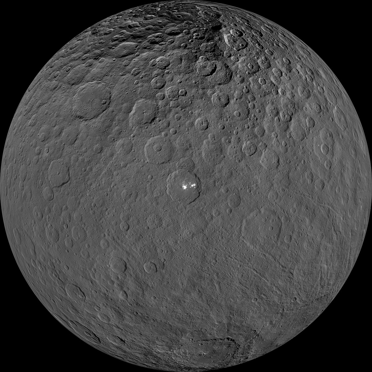
Ceres is different. It was the first asteroid to be discovered and is by some distance the largest. Ceres contains a quarter of all the mass on the entire asteroid belt. (That sounds more impressive than it is: the mass is just over 1% of that of the Moon.) But it does not look like the others. It is the only asteroid that is round, pulled into that shape by its own gravity. That qualifies it as a dwarf planet: Ceres is the only one in the inner solar system. Vesta, which is a little smaller, is nowhere near round. That already tells you that Ceres is made from weaker materials. Vesta is rocky, a proto-planet in all but name. Ceres is different, like no other planet in the inner solar system. It is midway between the rocky objects of the inner solar system, and the icy moons, comets and dwarfs of the outer solar system. It is unique – and being unique can be a lonely experience. Ceres could have empathized with lonely George, the last of its species for a century of its life. But for science, uniqueness is an opportunity. Scientists love studying something that is different from anything else. There is so much to learn. And in its uniqueness, Ceres may hold the key to one of the mysteries of the solar system. Perhaps it can tell us where Earth got its water from.
This is the third instalment of the Dawn trilogy. Part 1 was about the spacecraft and its unique propulsion system. Part 2 discussed Vesta. They can be read independently.
Ice and rock
The problem of Earth’s water is a simple one. Planets grow from smaller things which collide and stick together. These smaller things must be solid: baby planets have too little gravity to hold on to any gas. For something to be solid, the temperature should be below its sublimation temperature. Rock is fine up to temperatures exceeding1000 Kelvin. This allows space rocks to exist as close as 20 million kilometers from the Sun. Indeed, Mercury is some 60 million kilometers from the Sun, end even though a bit hot, the planet is neither melting nor evaporating. The asteroid Icarus gets even closer to the Sun than Mercury, befitting its name, but it too is in no danger, apart from getting a bit toasty and thoroughly sterilized. The Parker Solar Probe which was recently launched is playing a much more dangerous game. It will get so close to the Sun that its temperature will reach over 2000 Kelvin. That is too much for most materials. Most of the spacecraft will be hiding behind a thick and innovative sun shield, made from carbon which is stable even at these temperatures. The solar panels will have to peek around the sun shield (for obvious reasons) but they contain an active cooling system, and will limit their exposure to the sun to stop them from getting too hot.
Ice is more fragile: it evaporates at much lower temperatures than rock or metals do. Under vacuum, ice becomes vapour at 200 K (snow in vacuum requires much lower temperatures than snow on Earth). Those kind of temperatures are only found further our, at 500 million kilometers from the Sun or more, three times the distance from the Earth to the Sun. The limit for frozen water is somewhere within the asteroid belt. Planets, moons, or other objects which formed further out could incorporate ice, and because both oxygen and hydrogen are much more common in the Universe than silicates and other rocky elements, they quickly become mainly water. This allowed comets to form, as well icy objects such as the moons of the gas giants, with their thick oceans – and even Pluto. A comet could not have formed in or inside the asteroid belt, because of the lack of frozen water. This limit is called the snow line. Sometimes we see a comet, unwisely, getting very close to the Sun, the proverbial snowball in hell; they become spectacularly bright (albeit difficult to see because they are so close to the Sun), but afterwards they often disappear, completely vaporized by the heat. They are called the kamikaze comets.
This also explains how rocky planets formed. They are made almost exclusively from elements that are rare in space, such as silicon and iron. These are the only elements which could form solids close to the Sun: all other elements evaporated and disappeared before the growing planet could capture them. Vesta belongs to this group, and it is dry and dusty, without water. Ceres formed closer to the snow line, and it managed to attract quite a lot of water. Effectively, it is made of wet rock.
But the surface of the Earth, the ultimate rocky planet, also has quite a lot of water. How does that fit in? It turns out all the Earth’s water is near or at the surface. Down in the mantle, the planet becomes bone dry. The total amount of water, adding the atmosphere, the surface and the crust, is about three times the amount in the oceans. Compared to the total mass of the Earth, that is a very small fraction. It just so happens that most of it congregates around Manchester, giving the impression that Earth is much wetter than it really is.
Water: in spite of the occasional problems, we can’t live without it. But where did the Earth get its water from? And how come we have just enough to fill the oceans but not flood the continents?
From the fact that all the water is near the surface, you can already deduce it was a late addition. The water came when the planet was already fully formed and formed a wet veneer. But where did it come from?
The rocks of Ceres
We already knew quite a bit about the rocks on the surface of Ceres before Dawn arrived. No meteorite has ever been traced to Ceres, so we lacked the direct evidence that we had for Vesta. But it is amazing how much can be done with a large telescope. The observations showed a dark surface: the dark colours were interpreted as a mix between carbon and clay. Infrared spectra showed several characteristic absorptions in the infrared which indicated the presence of a form of phyllosilicates, containing water or ammonia.


Phyllosilicates, or sheet silicates, contain connected rings of tetrahydrons, where each tetrahydron consists of a silicon atom surround by four oxygen atoms. Three of the oxygen atoms are shared with other tetrahydrons. Often, captive OH molecules are present within the ring. Phyllosilicates form from weathering of rock, involving water. Clay is an example of a phyllosilicate, and this was a good candidate for part of the surface of Ceres. Water is itself difficult to detect from Earth, because the water in our atmosphere gets in the way, and you don’t know what is space water and what is local.
The density of Ceres was found to be around 2100 kg/m3. This is intermediate between silicate rock and ice, which suggested that Ceres was made of rock with a significant fraction (20-30%) of water.
Where would you expect the water on Ceres to be? After all, on Earth it ended up on or near the outside. Models suggested that the radioactive elements presents in the young solar system would have heated up the interior of Ceres quite effectively. Even if Ceres formed a little later, when the strongest heat sources would have decayed, the water in the interior would still have comprehensively melted. The silicate rock would have ‘weathered’ at this time. The heavier elements would have sunk through the melt, and the water and altered silicates would have migrated upward. These models predict that the core will be dry rock, and the mantle of Ceres will contain most of its water. The early radioactive heat has long gone, and the interior will have cooled down. Even in the mantle, the water became ice.
Dawn confirmed this basic structure. The core of Ceres has a radius of around 250 km, and the ice-rich mantle is some 100 km thick. The outer crust has a thickness of 30 kilometer on average, with a thicker region close to the equator and a few near-holes where an impact did real damage. The density of the mantle was found to be 2400 kg/m3. The crust has much lower density, 1200 kg/m3, almost low enough to float. The mantle is rock with ice, but the density of the crust suggests it is more like ice with some rock. But the surface itself is pure rock: any ice would quickly sublimate under the faint sun.

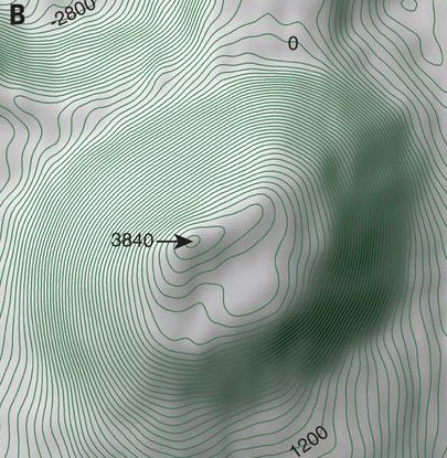
Thickness of the crust, as measured by Dawn. Ermakoff et al. 2017, Journal of Geophysical Research: Planets, 122, 2267–2293.
The surface
Of course, pictures and other observations mainly show the surface, and this is what gets most news coverage. Dawn arrived at Ceres in March 2015. A few images were obtained early on, and these caught the attention when two bright white spots were seen, of unknown origin. The first phase was spend in a high altitude orbit. Afterwards Dawn moved closer, finally getting close enough for images which could see details as small as 50 meters. The images became more detailed as Ceres moved closer, and slowly we deciphered the surface.
Let’s first gives some basics. Ceres is chilly, being 3 times further from the Sun than we are. The day-time surface temperatures hover around -40C (which for the convenience of our US readers is the same as -40F). The poles are colder and they even contain a few areas that are in permanent darkness. A day on Ceres lasts ten hours, and we are still close enough to the Sun that it makes a difference. So almost any ice ice that makes it to the surface, will over time experience unsuitably hot weather and slowly disappear in the heat of the day.

Craters of Ceres. The linear features come from debris thrown out by a larger impact. Note that many craters have a ghost-like appearance, looking as if they have been eroded or erased.
The images showed the usual crater-covered surface of airless bodies. But a closer look revealed that there was something missing: there were no large craters. The largest impact crater was 280 km across. Craters twice that size had been expected. There were 16 craters larger than 100 kilometer, but there should have been more than 40. Something was removing the largest impact scars. There were in fact a few basins, shallow depressions around 500 kilometer across. If these were the missing craters, the scars had been mostly healed. Volcanic eruptions could have covered them, as happened on Mars. But ice can do the same thing: a crater formed on ice becomes less distinct as over time the ice rebounds and flows back into the gap. The basins are densely covered with smaller craters, so the healing happened a long time ago, perhaps when Ceres still had radioactive heat which kept the ice ductile.

From Ermakoff et al. 2017, Journal of Geophysical Research: Planets, 122, 2267–2293. the colour shows the height above the standard surface level. The ancient largest basin can just be recognized around 120-150 degree longitude, and latitude from -20 to +60 degrees.
But ice turned out to be too flexible. Craters in ice would disappear too quickly. Somehow the material was stronger than ice, but weaker than rock. The missing ingredient appears to be clathrate hydrates: material where gas molecules are caught inside the ice. This strengthens the ice, and now the properties fitted with what is observed on Ceres. Indeed, this could have slowly erased the oldest and largest craters on Ceres.
Oxo and Haulani

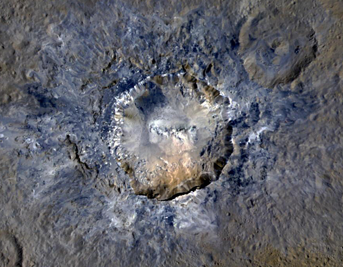
The impact crater Oxo turned out to be particularly interesting. It is relatively small, at 9 km diameter, but stands out because it is bright. This image shows the crater. The sharp structures suggest it is young: the age is estimated as less than 200,000 years. One side shows bright streaks. Spectra have shown that these are water: this is the only direct evidence for water on Ceres, and the fact that it was revealed by this impact shows that it is found just below the surface. Note the big slump on the south east (bottom right) which has pushed part of the crater rim a kilometer into the crater. On the north and west, the bright stripes suggest that the ejecta from the crater also contained water. But interestingly, the water is only seen on one side.
This image is of a crater called Haulani, 34-kilometers in diameter. It shows a blueish material surrounding and inside the crater. It is part of the ejecta blanket, but differs from the reddish surface material (the colours are of course enhanced and not as the human eye would see it). The blue material comes from below the surface and was excavated by the impact. It likely came from the water-rich material hiding below. Some other craters show the same effect, but it is only seen in young craters. The lack of impact craters inside of Haulani shows that this crater is also young. Over time, the blueish material degrades back to the normal surface composition.
White lava
The high plateau near the equator is called the Haunami planum. This region caught the attention very quickly after Dawn’s arrival. The first images showed a bright spot in this area. A closer look showed that the spot was double, with one half spot in the very center of a crater. The crater is now called Occator, and is 92 kilometer wide and 4 kilometer deep. The crater itself is unexceptional, apart from some clear landslides along the rim, with debris lobes. One of the lobes covers a quarter of the crater floor. The spots are the outstanding feature. There are some other spots on Ceres, but none are as bright as these. What are they, how did they form and why are they in the centre of an impact crater?
The spots were given their own name: the one in the center is named Cerealia Facula and the off-center one (in fact a cluster of spots) is known as Vinalia Faculae. The names do not roll off the tongue. The center one is located on and around a central dome 400 meter tall and 3 kilometer wide. It is surrounded by a depression, 11 kilometer wide and 600 meter deep, within the main crater. The surface around the dome appears to contain carbonates, forming a dark material.

Occator crater, with its bright spots

Fractures in Occator
The central dome is surrounded by a pattern of fractures, some concentric, some more complex. It is as if something tried to push its way out, and managed to bulge and break the surface, without actually escaping. When did this happen? The crater is estimated to be 30 million years old. But the dome appears to be much younger, perhaps only 4 million years. Whatever happened, it was long after the crater formed. There are some remnants of a central peak, partly obliterated by the dome.

From Nathues et al, 2017, Astronomical Journal, 153, 112

Topography
The topography gives another indication that the white material came from below: it is found only where the crater floor is deepest.

Dawn measurements told us what the white material is: it is sodium carbonate, a kind of salt. Cracks and fractures showed that it came from below. They allowed water to percolate up and reach the surface. There, the water evaporated and disappeared (it is near the equator, after all). But the water was briny, and the salts in the water stayed behind. The sodium carbonate is white. Carbonates can contain other elements than sodium, and this can change the colour. Pure carbonates are very dark. It gives a stark contrast.
There are stlll many questions. Did the dome form from below or by deposition of salt? Did the water come up from a shallow reservoir or from deeper? Was heat involved? Why did such spots form here? This remains unclear. But the spots of Occator have given us a view of the ice and brine hiding below the surface. And can we call this kind of activity volcanic? It involves molten material coming to the surface through cracks. But perhaps Ceres is a little too wet for liquid water to count as magma, and the dome is a bit small. It is a borderline case.
Ahuna Mons
But there is a real volcano on Ceres. It is the only volcano on a unique planet: perhaps this is the loneliest volcano in the Solar System. Dawn kept it company.

Ahuna Mons. The vertical scale is exaggerated by a factor of 2. Source: NASA
Source: Ruesch et al., 2016, Science, 353
Ahuna Mons is a pyramid-shaped mountain, 17 kilometer wide and rising over 4 kilometer above the surroundings. It really stands alone: the region is undulating but not hilly, and the mountain seems to come from nowhere. And although there are higher regions on Ceres, there is no other mountain like it on the entire dwarf planet. It is unique.
The top is partly flat, giving the pyramid a mesa-like appearance. The mountain stands next to a crater so that the side abuts the crater rim, but the crater and volcano appear unrelated. There are fractures visible on the top. The sides are uniformly steep, 30 to 40 degrees and have streaks from rock falls.
The crater is estimated to be 200 million years old. The surface of Ahuna Mons appears to be considerably younger than this. The streaks along the side show that the slopes are still unstable. The stripes will slowly erode over time, and the fact that they are clearly visible shows they are young. (‘Young’ should be read in a relative way: perhaps up to a few tens of millions of years, which to an astronomer is toddler age.) The slopes still have a very sharp separation from the surrounding material: again this will smooth over time. In space there is still erosion, due to a continuous bombardment by micrometeorites. The meteoric rain mixes up the upper centimeter of the surface within about a million years in a process that (somewhat optimistically) is called gardening.
There are several ways to form such a mountain. There is compression, a tectonic process which forms mountain chains on Earth. But this creates faults and those are not seen around Ahuna Mons. The second way is emplacement, where a magma chamber inflates the surface. But this requires a thin, elastic crust, more so than Ceres appears to have. And there is extrusion, where you push stuff out through a hole to the surface until you have a mountain. This is similar to how a volcanic cryptodome (or lava dome) works, and it is the most likely explanation for Ahuna Mons. The structure is not uniform: there are multiple small hills and short separate fractures which suggest the extrusion was not a single event but happened over a long time. The lack of lobes and the steep slopes shows that the material had a high viscosity, and cooled by conduction within a hundred thousand years.
This model suggests that Ahuna Mons formed from a cryomagma creating a massive cryptodome. The cryomagma is thought to be a combination of chloride-rich brines, carbonates and phyllo-silicates, and water ice. In this mixture, the brines would have melted, with a melt fraction of a few per cent, allowing the magma the travel up. The fractures that allowed the magma to move up may have come from the nearby impacts.
This leaves one question unanswered. What provided the heat to create the melt? Ceres is a small world, which cooled down a long time ago. The answer may lie in the past. Minerals can dissolve into liquid water, and at one time Ceres had liquid water throughout much of its interior. One of those elements was potassium. It has a radioactive isotope, 40K (K stand for the germanic name, kalium). Early on in the evolution of Ceres, this became dissolved into the icy mantle, enriched it, and migrated with the briny water. Now there may be pockets of enhanced potassium below the surface of Ceres, ready and waiting. 40K has a half time of a billion years, and so it is still active.
Ceres is rather warm for an icy body because it is relatively close to the sun. Temperatures below the crust are not far off values where a bit of melt could occur. Add a bit of excess heat from radioactive potassium, and Ceres is ready for action. Whenever conditions are right, a little melt happens and the viscous cryomagma begins to travel towards the surface, if it can find the right fracture. On top, sometimes the sticky fluid may create salty puddles, leading to white spots. At other times, perhaps once in a 100 million years, a 4-kilometer tall cryptodome may form.
So Ceres isn’t a lost cause. It is like a teenager in the early morning – to all accounts dead to the world, but with hidden energy inside. It holds hope and promise.

Part of the dome of Ahuna Mons
Earth
What does this tell us about the mystery of Earth? In the traditional model, Earth obtained its water through a hail of comets. They formed in the outer solar system where ice was the main solid. But it takes a lot of comets to carry an ocean. Dawn showed us that there were water-rich asteroids much closer to us. Jupiter would have disturbed the orbits of many of them, sending them into the inner solar system where Earth, the largest of the terrestrial planets, was ready and waiting. All it needed was the right asteroid to come too close and get caught in the spider web of gravity.
In spite of its tiny mass (0.01% of Earth), Ceres contains a lot of water: roughly 10% of the amount on Earth. Earth needed a couple of large icy asteroids, not too many, not too few, but just right to fill the oceanic basins. Too few asteroids would give Earth a wet crust but without surface water; too many would cover all the continents underneath kilometers of water. We were looking for the Goldilocks asteroids. Perhaps one of those icy asteroids was just right for us.
An object twice the size of Ceres could have provided Earth with all the water we would ever need. Was Earth lucky, and did it win a space ice lottery? Only Ceres knows.
Ceres and Vesta are the two bosses of the asteroid belt. How different they are! One is a protoplanet, the kind of object from which the Earth formed. The other is a water container, and example of the kind of object that may seeded the Earth with water and changed its future. Dawn really did find the morning glory of the Solar System.
Albert, August 2018

Originally this post stated that Ceres contained more water than Earth does. This was a numerical error (wrong by a factor of 10), as pointed out by a commenter below. It has been updated to fix this mistake.


Fascinating! Thank you very much, Albert. In a nerdy way, this was a thriller!
Just a heads up. RV Nautilus has arrived on the South coast of Kilauea and is mapping the sea bed. live. It’s fascinating! here’s the link http://www.nautiluslive.org/live/quad
That is fascinating! It seems they are looking for the underwater lava flows from the Leilani eruption.
They have said they didn’t know the true size of 1840 or 1960 because of the unknown volume that went into the sea so this is a very important part
Hi Diana, how are you ? Ursh
I.fine but my kness are not LOL ! Life is “interesting” . Never a dull moment!
A small swarm at Skaftafell. Perhaps glacial activity?
Hoping emails will work this time…
Never mind, I somehow didn’t confirm subscription for the last post (d’oh!)
Lovely as always but i’m trying to figure out the last picture?? “Sugarwater”???? frozen droplet of water? something my grandkids made with glue and sparklies?? Don’t think they can’t … 😉 Best!motsfo
It is a photo of a raindrop falling on dry sand!
Does Earth’s water budget include that entrained in the crystal structure of ringwoodite? I’ve heard tell that there is more water than in all of the oceans tied up in that material in the mantle. (And it might be involved in the 660 km discontinuity)
Yes, it does, although admitting that the numbers are uncertain. The estimates are mostly between 2 and 3 times the mass of the oceans, and I picked the higher range. You can probably find even higher estimates but overall, water is a very minor component of the Earth’s mass and any water in the mantle was carried down by subduction.
Jeebous… Mag 8.2 (preliminary) 281km NNE of Ndoi Island, Fiji (fairly deep 580.5 km)
https://earthquake.usgs.gov/earthquakes/eventpage/us1000gcii#executive
Predominantly Normal Mode faulting.
TSUNAMI INFORMATION STATEMENT NUMBER 2NWS PACIFIC TSUNAMI WARNING CENTER EWA BEACH HI
1053 AM CHST SUN AUG 19 2018
...NO TSUNAMI THREAT TO GUAM/CNMI FROM A DISTANT EARTHQUAKE - UPDATE...
THIS MESSAGE CONTAINS REVISED EARTHQUAKE PARAMETERS.
NOTE REVISED EARTHQUAKE MAGNITUDE. → [8.2]
https://www.tsunami.gov/events/PHEB/2018/08/19/18231000/2/WEGM42/WEGM42.txt
Using Wells-Coopersmith.
Average displacement 5.2 meters, (Max) surface rupture length (on the seafloor) 123.03 km. With a down-dip rupture width of 53.70km, it might not even be discernible at the surface. (It was 580.5 km deep)
That quake lit up th NZ seismograph network – despite being a couple of thousand km away.
Was one of the largest deep focus quakes ever recorded – the largest was a M8.3
https://en.wikipedia.org/wiki/2013_Okhotsk_Sea_earthquake
One thing you guys aren’t missing out on, are plots that I make while inebriated. Some of them appear quite strange when I run across them the next day. All I can do is wonder “what was I thinking?”
…wait, I know what I was thinking of on that one…
BTW, when melatonin doesn’t work, Jim Beam will.
… or not.
Actually ran across a guy in line behind me that smelled like he got the wrong end of a pole-cat.
How do you approach that situation? Recommend tomato juice or just flee?
Don’t run across him. 🙂
More quakes in Lombok, same area and shallow. A bit stronger than would be expected for an aftershock. An M5.4 was near Sembalun, an ancient caldera east of Rinjani
Rinjanistone? 😀
😡
OO. That didn’t work… i’d put the two : in and then put a x and out popped a mad emoji…. i meant to convey that Your comment, Lurk, on Rinjanistone gave the message but i agreed but had no more input…. Communication is always foggy at Best!motsfo
Normally I rather envy people going to places with an active volcano.
I wouldn’t want to be in Lombok though. The chance of something really nasty seems quite high.
Some of my family are booked for Bali in the next couple of days.
As long as they stay clear of the exclusion areas they should be fine. An alternate hazard are the locals. From nearly every eruption video I have seen of Agung, they seem quite surprised that anything is happening at all. Since they live there, they must have one of the shortest memories of any population on the planet. This could indicate that as a population, their attention to detail is quite low. The sort of person that would miss a stop sign or a traffic signal change. (those are much smaller than a volcano, and they seem to be constantly surprised by it.)
I had an acquaintance with a small computer shop near Phuket. It was trashed by the tsunami and he managed to survive and get the shop back in working order. Two years later he was killed on a scooter. It always seems to be the unexpected threat that gets you.
it looks like the Australian plate is on the move from NZ right around to sumatra, thewhole globe will eventually reverberate from this quake being so deep, something must have triggered it ?
Jumping on Ceres must be amazing!
With only 1% of the Moons mass the gravity is Indeed very very low. You can take enormous jumps and slowly land a long distance away.
The horizon will be very close since Ceres is so very small
I wonder if escape velocity is achievable with muscle power alone… or do you need beans?
Its not high but I think anything big enough to be round would have a high enough escape velocity to prevent that.
A baseball game there would be quite something; would they call it the World Ceres?
(I’ll get my coat)
I once calculated whether a cricket bowler could throw a ball into orbit. The answer was no, but not by that much: for an asteroid a few times smaller, a top bowler could – and catch the ball coming from behind a hour later.
Ceres escape velocity is about 500 m/s, so I dont think anyone is jumping off it any time soon… Its still only 1/22 of earth but I guess all that does is show how big space really is.
There are also quite a lot of ceres-type objects beyond the asteroid belt (one of them even has rings) and by statistics there are probably thousands in the Oort cloud. I think by statistics there are probably also at least a few moon-mars sized objects (big enough to be planets) out there too but they will never be seen if they are that small.
It is frustrating that there is no realistic way to observe the Oort cloud, we can observe things at the edge of the universe but we cant see much closer stuff we could actually get to within a lifetime using existing technology. It will also be a very important part of leaving our solar system if we can discover a larger object which has decent gravity to set up a proper base on, a mars-earth sized Oort cloud object would be very valuable especially if it also lines up with a potential interstellar destination like trappist 1 or alpha centauri.
Great thoughts! But I have to disagree with that large of a gravity well at that distance as an advantage. What would a large gravity well provide?
It’s not the gravity that is an advantage, you are right in that it would be a disadvantage (but not as much as it probably wouldn’t have an atmosphere at that distance and that is a big difference)
The advantage is that you could use it as a base to resupply on the way and not have to rely on accidentally finding a comet which would be statistically extremely low. It is like the much debated argument on whether we should build a moon base before having a go at Mars or Venus because the moon is much closer and launching from the moon would be way easier. Also you would have to get energy to make the fuel and relying on a thermoelectric generator is not an option for an inhabited spacecraft. The sun will be no help either, but if it is a big enough rocky planet then you could use geothermal, and I have read that water ice on Europa probably has a lot more H2O2 and radical oxygen anions in it than ice on Earth, and assuming any ice exposed to the sun in the vacuum of space will do that, extracting that and combining it with something oxidisable (like methane/ethane ice) could be an obscure but potentially viable energy source, and give CO2 which could be given to plants if needed. H2O2 is also a not very good but still usable rocket propellant just on its own too.
The same idea of Europa having reactive oxygen species in its ice is also a possibility of there being much more complex life in its ocean than just bacteria, allegedly there could be enough O2 in the water that even fish with a high metabolism like sharks or sailfish could be put in it and survive according to the calculations. Really all the more reason to go there.
.” What would a large gravity well provide?”
A slingshot.
Good luck with the Delta V calculations on that….
You could jump 50 meters high and 200 meters far. You would be airborne (?) for half a minute. But to escape would require a speed of 500 meter per second. A bullet fired straight up would still fall back – eventually.
Thank you. But I was actually referring to the beans. In retrospect, it was an idiot question anyway and not important.
If someones flatulence is getting anywhere near that level of thrust, they have more problems than just being stranded on an asteroid.
Lombok is in big shit. 6,9 now….. will it not end.
This is beginning to look like a fault line. The new quakes are bit east-southeast of the previous ones, following the edge of the mountain but moving away from Rinjani.
Comment deleted on request -admin
emptied as requested. Deleting comments sometimes causes problems in Wp – admin
Two powerful quakes (Mw6.3 and 6.9) just now under the NE flank of Rinjani. There appears to be a lack of aftershock activity…which is kinda curious given the hypocenter’s are relatively shallow (7.9km-35km). My suspicion is the fracture(s) occurred within ductile rock, which would not be that surprising given the proximity to the volcano’s central vent (Anak Segara).
So there have been 4 6+ quakes under rinjani in the past 2 weeks, maybe it was a failed big quake that instead ruptured as a series of smaller quakes (presumably there will be more in that case). Their occurrence under an active volcano is interesting, it seems hard to rule out a connection. I really doubt this will lead to anything significant though, it had its big VEI 7 only 800 years ago and 50 km3 of magma in 800 years is out of reach of any normal volcano.
There is always the argument is this a single system (Rinjani-Segara) which is the generally accepted version or do the two centres have independent plumbing? If the former a Big Bang event would be extremely unusual, although Barujari might get a bit lively, since its innards will have been ‘all shook up’ If they are separate systems – well Rinjani is a massive stratovolcano, with one (possible, small) eruption in at least 800 years, in a region where several similar cones have gone spectacularly caldera in recent times
I somehow doubt one of them could do a VEI 7 without setting the other one off if they are that close, their magma chambers would overlap a lot and probably be merged. Barujari is also pretty much exactly in between the middle of the caldera and rinjani.
There is a lot aftershock activity ongoing …
This is the Agung channel, but now all seismo activity is related to near Lombok.
PLWG is Rinjani (now failed soon after the earthquake begun).
https://www.facebook.com/ikaika.marzo/videos/1943985482320645/
There is still lava flowing into the ocean, 2 weeks after the eruption ended…
The area where Kapoho was before was actually one of the oldest exposed surfaces on kilaueas lower east rift, it formed around 1500 years ago, so this area had been protected until this point. One thing I did notice after making the outline of the new lava in google earth is that the lava seemed to turn east towards Kapoho after reaching the 1790 north flow, some of it ended up flowing over it anyway but it seems like most of the lava turned east and then into the kapoho graben. I dont know if this is relative coincidence but it seems unlikely. There also hasnt been a single lava flow in recent time that has been anywhere near as big as the new flow anywhere in the lowest part of the east rift, in most cases the lava seems to have just flowed directly to the coast but in this eruption it ended up getting stuck in the rift zone and filling in a gap.
Something I just realized, if the Parker spacecraft’s shield will reach 2000 K then why does it even need solar panels, surely it would be easier if it just had a steam dynamo with pipes going through the shield? I know having pressurized material on a spacecraft is risky but its not as risky as having to put its only power source into an environment they can only stand for a few minutes.
A steam dynamo would cause problems in the absence of gravity. There is nothing that forces separation of the liquid and the steam. Spacecraft also have issues with rotating systems. Like a helicopter, it needs something a compensator otherwise the entire spacecraft will rotate in the opposite direction. The main power sources are nuclear (which does provide heat) and solar. But extra heat in a spacecraft already operating at the limits of its temperature domain is problematic.
Well you could offset the spinning by having two of them going in opposite directions at the same speed, maybe with the speed set to a maximum that can easily be exceeded so they always operate at the highest they can go. And instead of using water you could use something that is always a gas but which can vary with density a lot depending on temperature, like CO2, if it only needs a relatively small amount of power to run then the dynamo doesn’t have to be very powerful.
I guess I’m not a spacecraft engineer but it seems like they really enjoy adding seemingly unnecessary complications that could easily go wrong very quickly when really all that is being done in this case is basically sending a camera in a box as close to the sun as possible. I don’t know exactly what else is being looked at (presumably magnetic fields and the coronas extremely high temperature) but magnetometers aren’t that expensive and neither are high quality cameras these days. If the heat shield is made of carbon (presumably graphite) then that is basically free at this point in comparison. Maybe they had to add all the expensive parts to justify getting the money for a big rocket…
If there are any spacecraft engineers reading this and getting annoyed I am sorry… 😉
Nice photo of a new dome at Merapi: http://www.vulkane.net/blogmobil/
Lombok – how probable is it that those quakes are the precursors of a big one in the 7-or-above territory?
And with all the ruminations about Hawaii – I liked the idea of a speculation alert! Makes it easier to distinguish facts from hypothesis.
re up the thread… sleeping medications…. doc prescribed med gave me the weirdest dreams… one night i washed 14 loads in real time and another night i scrubbed the kitchen floor board by board.. kept waking up exhausted… life’s weird… 🙂 Best!motsfo
I thought this may be of interest to people here. I am watching with anticipation both as a biologist and a vocano watcher. https://www.youtube.com/watch?v=gYeZASkZ33g
It’s very nice to see you back here, Diana. Hope all is well! Thanks for the video!
Alternate view of the Parker Solar Probe launch.
https://youtu.be/AdtkBQyqFao
I just found this, its a video of fissure 17 as it was just opening. In hindsight this video is showing the start of the end for most of lower Puna, before this point there was still some chance the eruption could stop, but once fissure 17 started and lasted for more than a day it was clear this would be more or less the worse case scenario.
https://www.youtube.com/watch?v=UweRd54th28&ab_channel=TimO%27hara
And also by Tim, one of the best videos of a lava fountain you will ever see. I guess HVO missed it because this is definitely way over 100 meters tall…
i remember watching this live…… not knowing what was going to happen… i enjoyed the view, at the time… Best!motsfo
I remember watching it on May 18 only an hour or two before the new lava started erupting on the other fissures (and maybe a day before the video above). It was quite startling how much fissure 17 picked up, before that it was only going barely above that tree and seemed to be declining, and was still the viscous explosive andesite, but then it started jetting high above the camera view, and you could actually see incandescent lava flowing away from it, as well as the cinder cone. It was quite a sight.
This might be my last Hawaii related comment until something else happens there (which probably won’t be in that long realistically).
I have been rather in depth with my research on kilaueas long term cycles, and I think I have finally got it sorted out, at least as well as we can understand now, part if my theory is still dependant to some extent on events that have not occurred as of right now.
Kilauea seems to go through two cycles of activity, one is long term and seems to have a recurrence of around a millennium or so, and the other is a shorter term cycle that repeats every few hundred years. It is one of these shorter cycles that has just ended with the recent eruption.
The longer cycle seems to be based around average supply rate. Between 2000 and 1200 years ago the caldera was deep and never seemed to have gotten close to overflowing. Most of the activity was very explosive and included some really violent eruptions. This indicates that the general supply rate was a bit lower on average than it is now, not by much but enough to make a difference. Mauna loa is known to have been relatively more active than it is now, it was the last time it added significantly to its overall mass through shield building. The formation of moku’oweoweo is believed to be tied to the eruption of the pana’ewa lava flow which forms part of Hilo, and which was probably one of the biggest lava flows in Hawaii during the Holocene, being about twice as big as holuhraun in volume and likely erupted in less time. This occurred about 1300 years ago, not too far off when kilauea is known to have become more active. Kilauea started overflowing its caldera (the powers caldera, about twice as big as the current one). Around 1200 years ago, and over a long time period of about 500 years it built up the massive observatory shield, which buried the entire southwest and most of the upper east rift zones, and also sent flows northeast towards mountain view and northern puna. After about 1300 it seems to have largely stopped, and around this time there was a shift to the east rift where the large shield of kane nui o hamo formed.
This is the start of the shorter cycle, and this eruption was probably very similar to pu’u o’o, it also possibly ended the same way with a large downrift intrusion, maybe to form the poorly dated puulena craters and pu’u kaliu cone near Leilani estates. Regardless, after 1400 activity returned to the summit again, along a series of fissures that formed in a location further north than most eruptions. These initial eruptions were probably quite intense with significant flow rate and fountaining, but after some unknown time it stabilised and eventually formed the aila’au shield. This eruption was probably somewhat episodic, there have been several separate lava flows identified, but there was probably continuous eruption from vents on the shield for the better part of a century. In the late 1400s things again shifted downrift, quite far this time, forming a relatively small shield above Leilani estates. This seems to have been terminated by a large eruption of picrite basalt in the Leilani estates area, on a very similar line to the current eruption. The further downrift cone of halekamahina possibly also dates from this eruption. This collapsed the observatory shield to form the first true caldera in 500 years. This started to refill immediately, with massive fountains depositing tephra all around the summit. In the muddle if this there were a few eruptions on the east rift, at pu’u honuaula and kapoho crater, probably similar to the 1960 eruption. Some point in the late 1700s heiheiahulu formed, this was probably a fairly large eruption of at least 1 km3 of lava and it probably lasted at least a decade. This eruption was very likely terminated by an eruption in or shortly before 1790, probably the biggest eruption on the lower east rift in about 1000 years, erupting at least 0.5 km3 of lava along the entire LERZ and collapsing the summit to below the water table. Again it began to fill immediately, the water table causing violent interaction. Eventually it got to the point of near overflowing in 1924 before things stopped and didn’t return to the summit again. The large pu’u o’o shield eruption of 1983-2018 included very extensive lava flows as well as 3 shields being made. This ended wth yet another downrift intrusion, this time from a relatively small fissure but it produced an even bigger flow than 1790, the biggest lava flow on kilauea in recent time. This collapsed the summit again, presumably there will be vigorous eruption there within the next few months, possibly with explosive activity.
There also seem to be two distinctive kiknds of eruptions on the lower east rift. The first are generally smallish and are fed by direct intrusion from the summit. These eruptions are more likely to build cones and exisiting high fountaining, as exhibited in 1955 and 1960. The 1840 eruption is a subclass of this type, being fed by a deep intrusion that branched out below the main magma chamber.
The other sort of eruption are what I like to call terminator events. These are much bigger than other eruptions, as they are fed not direct from the summit but by intrusion from a long lived flank eruption on the east rift, and the entire volcano drains out to the level of the eruption. Caldera collapse is a trademark, and smaller collapses can occur in shallow magma bodies on the east rift. The lack of such structures forming recently might indicate the conduit to pu’u o’o was relatively deep compared to 1790.
Terminators are different to the other eruptions. They don’t exhibit high fountaining because the lava is more degassed, there can still be significant fountaining but not as high as otherwise. These eruptions are more like small flood basalts and cover significant parts of the LERZ. This years eruption seems to have been unusual in that it localised to a point and actually did make a cone. Lower puna doesn’t seem to do small eruptions though, all the historical eruptions have been around 0.1 km3, and the terminator events like the recent eruption can be getting close to the 1km3 range.
As said before, this will be the last time I post an extensive comment regarding Hawaii until something happens there. Judging from history though, that could be in the near future and it will probably not go unnoticed…
It would be interesting to add Mauna Loa to this overview. Even though their magma is independent, their chambers do seem to respond to each other. What do we know about the time series of Mauna Loa?
It is harder to find information on mauna loa because it is way more inaccessible but I think it has a similar cycle but without long lived flank vents. However I would doubt mauna loa erupts as much lava as kilauea, it’s flows are very extensive but few eruptions there build anything that is topographically prominent so it is likely that the volume is less.
Kilauea has possibly erupted as much as 50 km3 of lava in the last 1000 years, while mauna loa has probably erupted only about half that amount, it’s flows cover a wide area but the generally fast and short nature of its eruptions makes me doubt the flows are as voluminous as on kilauea.
Mauna loa did go through some shield building around 1500 years ago though and it seems to do that at intervals of around 2000 years. It isn’t completely over yet, but it has far declined from the probably close to 0.4 km3/year rate it had in order to grow as fast as it did. We currently live in a time between the peaks of two Hawaiian volcanoes. Mauna loa has past its peak maybe 20,000 years ago, while kilauea has yet to reach it and will continue to increase in activity over the next 200,000 years or so.
If people had good boat technology 40,000 years ago and someone found Hawaii then, they would have seen a very different island where kilauea was just above sea level and mauna loa was continuously resurfacing itself to no end. Mauna kea also had glaciers then.
Many thanks for your insightful and interesting observations on Kilauea!
Reply intended to Turtlebirdman’s wrap up post. Sorry Albert!
The massive Mauna Loa eruption which formed the central caldera was around 1250-1300. After that, Mauna Loa spend some centuries refilling it.
This plot shows the anti-relation between Mauna Loa and Kilauea eruptions in recent times. It would be interesting to see whether this applied at earlier times as well. The plot is from https://pubs.usgs.gov/gip/117/gip117.pdf
Where did you get the date of around 1300 AD? Everything I have seen on it says it is well over 1000 years old.
I had to look for this again! It is hard to find published dates. The 1250-1300 came from . It is thought to be related to the change in summit eruptions where lava was flowing both directions, to rift eruptions. After the caldera formed it was too deep for this. Previously, there may not have been a significant caldera but a higher mountain.
Do you have a source for the dates? This one gives a date for the ML caldera formation at 1200 CE
https://volcanoes.usgs.gov/volcanoes/mauna_loa/geo_hist_summary.html
https://volcanoes.usgs.gov/observatories/hvo/hvo_volcano_watch.html?vwid=1205
The flow is apparently about 1500 years old.
There is also this map:
https://pubs.usgs.gov/ds/2005/144/images_plots/bimp.pdf
Most of mauna loa is quite old, the rock on the south rim of moku’aweoweo is also about 1500 years old, it probably formed immediately before the pana’ewa flow.
My link did not make it through the WP filter. Here are two: http://hilo.hawaii.edu/~kenhon/GEOL205/maunaloa/default.htm and https://volcanoes.usgs.gov/volcanoes/mauna_loa/geo_hist_summary.html
The issue is probably whether the Hilo flow is the same as the one that formed the Mauna Loa caldera. It may not have been.
It is possible the caldera formed at a later date but that means its summit was entirely inactive for 500 years which is unlikely based on its historical activity. The only flows from mauna loa in the last 1000 years seem to be from relatively smaller fast eruptions like those observed in historical time. There have been some longer eruptions like 1859 and 1880, as well as the long lived eruption in 1872 that filled in a lot of the caldera, but nothing really like what has happened on kilauea.
That comparison graph between the amount of lava erupted from mauna loa and kilauea is also pretty telling.
Mauna loa erupted about 3 km3 of lava between 1843 and 1984, a period of ~130 years, and while the graph shoes kilauea has erupted only about 2 km3 up to that point, since then it has erupted another almost 4 km3 with the rest of pu’u o’o as well as the recent eruption in Leilani estates, meaning it has erupted close to 6 km3 of lava since recording began, and most of that was after 1955, a period of only ~75 years. Kilauea has erupted almost twice as much lava as mauna loa in only half the time. It is the generally much faster eruption rate of mauna loa as well as its much greater size that gives the impression of it being the more powerful volcano. It was at one point, but the maths doesnt lie, kilauea is far out-erupting its larger predecessor in the modern day.
It is the random chance that recorded history began around the same time as mauna loa became more active that it is seen as being comparable, when it is quite clear looking at long term that kilauea is much more productive.
And for older eruptions, Kilauea may have put more into the sea. That would not have been counted in the numbers.
Yes it is considered likely that a significant part of 1840 went directly into the ocean. Unlike the recent eruption the 1840 flow channelized all the way to the ocean entry with no real flow spreading. This resulted in repeated littoral explosions that built a hill around the entry, but a lot of the lava ended up in the ocean directly without much resistance. That eruption was still a lot smaller than the recent one, or 1790, but its flow rate was about the same and it was much bigger than 1955 or 1960.
I would also not be surprised if a significant part of pu’u o’o ended up in the ocean. The volume of the June 27 flow (the only major flow which never had an ocean entry so its whole volume is visible) was between 0.3 and 0.4 km3, which is really a very big flow. Adding the peace day and 61g flows being about the same size gives about 1 km3 of lava since 2011, but with maybe 0.2 km3 of that ending up in the ocean. Assuming the same sort of thing was happening before then maybe up to almost 1 km3 of lava ended up in the ocean between 1986 and 2017, which is a big difference. It is also on the lower side as the flow rate was often higher earlier on, and was particularly high between 2000 and 2008 at almost twice as high as the 61g flow and lava was flowing into the ocean about 80% of that time period. I dont know if much study has been done on this aspect, but if the flow rate was fairly constant and about 80% ended up in the ocean then that is a massive difference in the volume. If pu’u o’o is calculated from its above sea level part then adding 80% of that onto it again makes it around 8 km3. Doing the same for mauna ulu makes it around 1 km3, and doing it for the aila’au and observatory shields makes them around 11 km3 and 18 km3 respectively… The ratio of lava that entered the ocean might have been relatively lower in those but on a scale as big as that even adding 20% makes a big difference. This really shows how it is eruptions like this which build the islands, and it also shows how much more productive kilauea is even better than before. Eariler on I said about 50 km3 of lava could have been erupted in the past 1000 years, if half of eruptions are big enough to have ocean entries and lava flows into the ocean for 80% of that time, then the volume is really about 40% bigger than 50 km3, which is about 70 km3 of lava, in only the last 1000 years…
There is also one big thing to consider when comparing the volumes of lava erupted from mauna loa vs kilauea. Basically every major flow on kilauea in historical time has had a significant ocean entry, while only about half of mauna loas flows have had an ocean entry, so most of what mauna loa has erupted in historical time is on land, while a lot of kilaueas is not.
Ok I have to break my own statement from before, I have some more stuff related to hawaii 😉
I looked through the bulletin reports on global volcanism program for kilauea, and found some numbers for how big the eruption was at some points, and after some more research I managed to put up a list that shows the entire eruption of kilauea between 1983 and 2018.
Pu’u o’o/kupaianaha/TEB was a total of about 7 km3, a lot bigger than the usual estimates of ~5 km3.
These are the parts of pu’u o’o and the estimated percent of the time lava was entering the ocean.
1983-1986 – ~0.4 km3, ocean entry 0% of the time (removed/outlier)
1986-1992 – ~0.7 km3, ocean entry ~70% of the time
1992-1997 – ~0.5 km3, ocean entry ~80% of the time
1997-2002 – ~0.5 km3, ocean entry ~70% of the time
2002-2004 – ~0.3 km3, ocean entry ~70% of the time
2004-2007 – ~0.5 km3, ocean entry ~85% of the time
2007-2011 – ~0.7 km3, ocean entry ~70% of the time
2011-2013 – ~0.3 km3, ocean entry ~50% of the time
2013-2016 – ~0.5 km3, ocean entry 0% of the time
2016-2018 – ~0.3 km3, ocean entry ~70% of the time
1983-2018 – 4.7 km3, ocean entry ~ 65% of the time, meaning most of the lava ended up in the ocean at some point. This is actually completely neglected in everything I have ever seen about how the volume of the is calculated, and it really misses a lot of details.
Maximum volume is ~8 km3, minimum volume is 4.7 km3, likely volume is about 7 km3.
The eruptions where ocean entries are long lived actually get downplayed a lot, as can be seen here a very significant amount of lava ends up below the waves where it is not measured.
If a similar number exists for the long lived summit eruptions like aila’au and observatory shields, then again there is a potential very big difference. Those flows had to go a lot further so it would probably be a bit less than 70% of the time there was an active entry, but the difference over their duration could well add up to a very big number. Both aila’au and observatory probably erupted over 10 km3, quite a lot higher than I initially thought. It also possibly almost doubles the size of 1960 and significantly increases the size of 1840, and may well push the size of the recent eruption up to over 1 km3 because the lava delta is massive – new coast is formed over areas that used to be 200-300 meters deep ocean off kapoho and ahalanui.
Basically the worlds most well observed volcano was somehow erupting twice as big as we thought it was without being noticed…
Until this year I really thought I knew about as much as there was to know about kilauea, and that it would kind of just keep slowly flowing basically forever through my whole life, but this years events have shown me (and everyone else including HVO) that it is capable of way more than that. Honestly after this research it is hard to find any other volcano even slightly impressive now, sure tambora might have erupted 50 km3 of magma in only a few days, but it didnt erupt on a large scale for several thousand years at least before that point, and it will take possibly tens of thousands of years to recover, while kilauea causally erupts more lava than that in an average millenium and is only half of its true potential…
Thanks for the information and research you’ve done turtle.
Well, one of the other things my research has done is show me that it probably isn’t going to be very long before something else happens in Hawaii, so I might be breaking my own word quite often 😉
If what Albert said further down is true about the summit inflating slightly then it might not take long at all, actually…
I mostly agree with the short term cycles. I would say they are made up of three distinct phases of activity all of which observed during historical times. The most common of the three I think would be low rate summit activity, which happened during 1840-1955, eruption is mostly continuous and slow, it leads to partial caldera filling or overflowing, events in the rifts can happen but are rare.
Then there is the phase of ERZ activity 1955-2018?, characterized by an overall high effusion rate, very low activity from the summit, some eruptions of the SRWZ and strong activity in the East Rift. Sustained eruptions leading to the formation of shields can happen (Pu’u’o’o, Mauna Ulu, Kane Nui o Hamo, Puu Huluhulu and two overlapping shields in the Heiheiahulu area), but short fissure eruptions can also take place and tipically, at least during the historical period, smaller when happening in the upper and middle rift and more voluminous in the LERZ, I would say three or four phases of ERZ activity have taken place during the last millennium. ERZ activity can lead to collapse events that can shut down the ERZ and start a phase of high summit activity, 1790-1840, which can include explosive eruptions, high fountaining, lava lakes… inside a caldera, 1790-1840 was also characterized by unusually high SRWZ activity.
Mauna Loa was more active during the period of low summit activity in Kilauea (1840-1955) and also seems to have been quite active more or less between 1000-1500 which was mostly a period of overflowing from the summit (Kalue flows, Observatory Shield, Aila’au…), and less active during the 1500-1790 period which was predominantly (1600-1790) a phase of ERZ activity. Mauna Loa does seem to interact with Kilauea but the exact I dont know.
After the current eruption I think Kilauea will either go into a period of high summit activity or will continue with the ERZ, it might not be a clear transition but maybe combine both for years or even decades which is what I think might have happened after 1500, high fountaining presumably after a first collapse event was followed by explosive eruptions maybe triggered by further collapse connected to ERZ eruptions?
I saw on the HVO pictures that pu’u 8 doesnt have any lava in it now, but is still venting gas and spatter, so they still think it has paused. It is interesting because there is no evidence to suggest imminent reactivation but the vent is still active even after 2 weeks. Maybe this is quite normal but I would have expected the vent to be completely dead by now if it was really over.
From the looks of it, if it does fully reactivate it will have some pretty high fountains, as it is now just a single hole. I still dont think that will happen though, evidently there is not really any magma left above the elevation of the vent if the collapses stopped so suddenly, and the dike is probably too long for the average supply rate to keep it open.
If the summit doesnt reactivate then I think activity will go back to pu’u o’o, filling its crater possibly to repeat this years events again in a few months – a year or two, which would be quite a big deal. Maybe that is what happened in 1790 too, to cause its double rift.
I guess to really know how fast activity resumed after events like this in the past the events need accurate dates, all we know currently is that it is within a few years but that is a big time frame when kilauea usually erupts at least once a year anyway.
when one puts a hose in water to siphon it out, you would have to fill it and it needs to be lower at the out put, when you get an airlock it stops, almost instantly,, very similar to lava, with earthquakes it finds new ways because the lava is not flowing, so it gets going again some where else, easier ?? also heat and water could get pressure to blow the air lock away, just mendaring
Not manually checked M1,6 quake in the deadzone in Iceland
Also, there is a quite widespread pattern of unusual quakes. Most of them unchecked. Often, but not always, quakes like these are false detections by the automatic network. Let’s wait and see.
ASSUMING normal mode faulting, that’s about 0.03 mm displacement. (30 µm)
Would that calculation change i the dead zone if the rock there is hot and soft as suggested previously?
Probably, but Wells-Coopersmith had a quite extensive sample size that spanned many years to derive their equations. Ultimately, it boils down to brittle fracture dynamics. The big caveat from their paper notes that the formulas for reverse mode fractures do not fit at the 95% confidence interval… and, that the results (from all of the formulas) can vary by a factor of four.
The intention behind the formulas are to realistically get you into the ballpark when examining quake effects.
Still very small movements then.
I was going to dig around and re post the twinkie scale but didn’t have time so I just went with Wells-Coopersmith.
I made the twinkie scale to illustrate just how small some of the smaller quakes actually are. It gives the quake intensity in food-energy equivalent. The higher end of the scale switches over to generic cheeseburgers.
BTW, if you notice a correlation to the twinkie meme from the original Ghostbusters (the good one), it was the inspiration for the idea. However, the gargantuan twinkie mentioned there is not technically accurate. For the dimensions stated, the twinkie would have a different mass.
“Before Hostess Brands filed for bankruptcy, Twinkies were reduced in size. They now contain 135 kilocalories (560 kJ) and have a mass of 38.5 grams, while the original Twinkies contained 150 kilocalories (630 kJ) and had a mass of 42.5 grams. The new Twinkies also have a longer shelf life of 45 days, which was also a change made before bankruptcy, compared to the 26 days of the original Twinkies.”
So, the Mag 1.6 works out to about 25 original twinkies in energy release. (15848931.92 Joules per the original Ricter scale as modified by Kanamori) {28.3 of the pending bankruptcy twinkies} Current twinkies? About 28, or 2.8 of these boxes;
And, as you see from the above text, they don’t have an indefinite shelf life as mentioned in some programs and movies (Zombieland).
Hurricane Lane is now predicted to curve around Hawaii. The forecast states “Based on the latest trends in the forecast, direct impacts on the islands appear to be increasingly likely.”
A reporters tour of Volcano National Park.
Oops. Someone just brushed up against the federal alarm on a fire apparatus just down the road from here at 3:30 AM. Big no-no unless its,a major event. People are sleeping. (Typically the switch is on the left of the floorboard and it is easy to accidently step on it)
This time we did not get the 300 to 500 meters tall Classic Kilauea fountains. Leilani eruption produced only moderatly high fountains.
Not enough gas.
I guess the Halemaumau lava lake and Puu Oo eruptions degassed the magma before Leilani erupted. Halemaumau 2008 – 2018 sourely removed alot of gas from the system.
As I said in my above comment I think there are actually 3 different kinds of eruptions kilauea can do. The first is high fountaining, which can occur at any point on the volcano but is probably most significant in newly formed calderas (hence why I think the near future will be interesting). This is fed by direct intrusion from the magma chamber, and when it happens on the flank it builds large cones. 1980s pu’u o’o is a good example, as is pu’u puai from 1959, and the 1960 cone, and in recent prehistory there was pu’u honuaula, where the webcam was, also probably formed from this sort of activity. These eruptions tend to be relatively small except for those which occurre at the summit after caldera formation.
The second sort of eruption is effusive shield building, which again is more common near the summit and might be restricted to the middle east rift and up by the rate of cooling of magma in a dike. The lowest shields are the 1500 shield and heiheiahulu, and they overlap so this could be the lowest point a stable conduit can exist indefinitely.
The 3rd kind of eruption is the rarest, the terminator eruption. These occur in distal parts of the rifts, and are associated with calderas forming, and are much bigger than other eruptions approaching 1 km3 but with similar duration to smaller eruptions (months not years). This years eruption was a terminator eruption. The 1790 eruption was also a terminator eruption. The notable part is that these do not feed directly off the summit chamber but instead form as a dike extending from a long lived eruption centre on the rift, exactly as this recent eruption has done. This means the magma is degassed relatively and so high fountaining is not a major part of these eruptions, as you said.
In saying that though, fissure 17 actually did show high fountaining for a few hours when new magma started erupting on May 18, probably because the dike breached into the andesite magma body feeding it and heated it up. HVO never saw this because it stopped and went back to normal before they did their overflight so they marked it as unchanged but the livestreams caught it, The fountain was definitely exceeding the 100 meter mark and you could see new fluid lava at the base overriding the older andesite.
Lane is now a category-5 hurricane, and heading to brush the west side of the main island and hit the other islands. I would expect that the navy is getting ready to ride the storm out at sea.
I wonder if enough rain will fall over kilauea to form a lake in halemaumau. I was watching a livestream yesterday and it has apparently been confirmed the bottom of the crater is well below the water table, but it is too hot at the moment for groundwater to seep in and form a lake that way. A lot of rain coming in from above could cool things down a lot faster though, either directly or by adding a lot more future groundwater.
Predictions are for 5 inches, up to 20 inches locally. It depends a lot on how far away the hurricane passes. The western and southern slopes of Mauna Loa could get really soaked. 5 inches is not enough to create a lake, but if all the water in the caldera drains into the crater it would be ten times deeper. Assume this soaks the crust and small phreatic explosions would not be impossible, even weeks later.
The rain is already producing lots of steam
Thank you.
My very best wishes to the Islanders, hope the storm track trends West.
Humanity aside, the effect of a dozen inches of rain into the slumping caldera and onto the lava streams, plus storm waves lashing the new, as-yet unstable shore should be interesting…
All but two of the models have it moving west and generally missing. The two that don’t say that are well known for being somewhat stupid.
might be fun to watch this the next couple of days: https://www.windy.com/19.580/-155.435?18.406,-155.449,7,m:edNaP5
Kilauea being earths most powerful basaltic volcano, can do very very tall lava fountains Indeed. And as say specialy when new caldera formations wakes up again. All the ash and basaltic golden black pumice in desposits around the summit of Kilauea is testimony of really tall fountains, like 1959 and much much taller than that. Likley some caldera eruptions and caldera ring fault eruptions produced 1 to 3 km tall fountains. Souch eruptions woud appear like a yellow orange geyser with a large black upper tephra part, lots of ash and peles hairs and tears are produced.
Souch magma haves to be very gas rich too.
Likley scenario when summit caldera wakes up again after accumulating pressure and magma.
Lava fountains 3km tall, would that be an effusive equivalent of a VEI6 eruption?
No that would be a VEI 4 with the intensity of a VEI 6, like grimsvotn 2011.
Energy-wise though it could actually be equivalent to a VEI 6.
0.2 km3 of basalt lava (about the volume of kilaueas 1790 summit eruption, which would have probably been a >1 km fountain if water didnt get involved) cooling to room temperature releases the same amount of energy as a VEI 6, the recent eruption at kilauea is as big as 3 pinatubos in terms of all the energy involved. The 3 biggest flood basalts in Iceland during the Holocene (thorsja, eldgja and laki) combined would exceed the energy of the toba eruption…
I dont think I have to say anything about how much energy is contained in erupting the 1000 km3 roza flow – the biggest of the Columbia river basalts. Or the 70 km3 of erupted lava every year at the height of the Deccan traps, the dinosaurs got lucky that the impact finished things quickly……
https://www.youtube.com/watch?v=uMF01pQw0TY&ab_channel=SiLenTGhosT24R
This is the best video of a really high fountain I can find, its the 1986 eruption of izu oshima volcano in 1986. These fountain are 1600 meters high, this is basically what happened on kilauea in around 1500, and probably what 1790 would have looked like if there was no phreatomagmatic interaction.
It is also what has a very plausible chance of happening in the next few years there too…
Hmm… an a Earth prominence…
Still Grimsvötn 2011 Ice – Free version woud have formed amazing fountains! 2011 woud form kilometer high lava fountains if it was ice free.
Probably more than 1 km, it’s eruption rate was probably almost high enough to go plinian even without water interaction.
Ceres does not have more water than Earth. It only has ~15% of the amount of water of Earth. It does have more water than Earth has fresh water though. Earth has more water than what is likely in the entire asteroid belt.
This was queued by our spam protector, as happens to all first-time comments. Future comments should appear without delay – admin
You are right and the post is optimistic. I had the wrong number: Pluto has more water than Earth but Ceres fall short by a factor of 10. Of course there used to be much more material in that region of the solar system, scattered by Jupiter (either resonance scattering or migration of the young Jupiter through this region). There should have been enough water in the entire belt at that time, but probably not in a single object.
The problem of giving the Earth enough water to have oceans but not so much to become a water planet remains.
The post has been updated to fix this error. Thanks!
Daily Fail on the Oregon coast 6.3 :
http://www.dailymail.co.uk/news/article-6087235/Oregons-biggest-earthquake-year-hits-Pacific-Ocean-6-2-residents-pray-no-tsunami.html
I gave my basalt rock from the Grand Ronde formation a bath today…
dried it and gave it a hug….
It would be nice to hear from TGMcCoy, our resident Oregon poster. Are you there, sir?
Tis I had to change my handle due to a harasser troll. Found out she had a cow’s tail under avatar…
Well – how good to hear from you! Hope you are well.
Been having physical problems with my hip and thigh one more time wit physical therapy -i hope there is not going to be(another0 operation. This unrelated to my artificial hip but an old injury…
Did get my Flight instructor’s rating renewed, however…
Hope to contribute more. One thing Albert’s post on Ceres.
-I couldn’t help think about the “Little Prince” and his little volcanic asteroid..
The Kilauea GPS is showing a little inflation. It is very minor but has been consistent over the past week. This is the GPS itself, not the length measurement. Pu’u’O’o was showing a bit more deflation but that may now finally have stopped.
I just read this, in the UK Independent Newspaper.
https://www.independent.co.uk/news/science/napoleon-bonaparte-defeat-battle-of-waterloo-volcano-indonesia-france-mount-tambora-sumbawa-a8503116.html
I’d quite like to hear your thoughts!
There might be an issue with “The electrically-charged ash “short circuited” the ionosphere, the upper atmospheric layer responsible for cloud formation” bit.
The Little Ice Age was still going on strong and Napoleon did have a record of “stepping in it.” His Russia campaign proved that. Nothing intended against Russians, but an old adage says you never wrestle with a pig because you will just get muddy and the pig loves it. To Russians, winter is just another thing to deal with during the normal course of the year. Just like Florida and Hurricanes. If you jump head first into something you and your forces are unaccustomed to, well, you are putting yourself at a disadvantage from the start. After that catastrophe (of his own making) he wound up at Waterloo.
As for the later “year without a summer,” it is much hyped for it’s crop failures… but one note that I read in a paper somewhere, is that Vermonts crop of “Flint corn” suffered no casualty in 1816. Flint is a much more durable variety of maize than normal “Dent corn.” Had someone known that the year was going to be pretty screwed, planting Flint corn would have been a viable option to deal with it.
Going into Waterloo, his forces were at a 1.6 to 1 disadvantage. Imagine if he had not lost 470,000–530,000 in his Russian excursion.
(Note: Russia has proven quite adept at “stepping in it” as well. Though they successfully occupied Finnland on two separate occasions, their casualty rate was around 4.5 to 1 in order to do it.
Object lesson? Be careful what you wish for. You might get it.
(And yes, that applies to the US as well. We were quite happy watching Russia get mired down in Afghanistan. Now look where we are at.) Cui bono? Whoever gets the mining rights to the REE.
With proper preparation it is possible to take.the Russians on, in Russia. So long as you’re not over ambitious.
The Germans proved that in 1914/17 and the Poles in 1919/21. Both smashed the Russians on the battlefield, then forced a favourable peace before the Russians could recover.
As for Napoleon going into Russia, it was a mistake, but a forced one. Napoleon, like Hitler, was running an economy based on pillage and plunder, and wasn’t able to break out of the trap because of naval blockade. When he’d robbed the countries he’d occupied dry, he didn’t have much choice but to take on Russia, or his empire would have crumbled anyway.
… now, about that whole Hurricane vs Hawaii thing. In my experience, the most valuable immediate tool to have available is a chainsaw. That gets you back to the road. A generator is handy, but most of the easily available ones have no where near the capacity to handle a whole house. Use extension cords to get power to your refrigerator and freezer. That way you don’t loose any food. ALWAYS keep your generator in a well ventilated area. Carbon Monoxide can quickly ruin your day if not outright kill you. Since I wind up having to have a generator available on short notice, I poured a small slab of concrete near my house specifically for putting the generator on it. Generators are much sought after, so you can easily put in a couple of eye-bolts for chaining your generator down so it doesn’t walk off. This was a large problem after Ivan 2004 here where literal assholes were stealing DOTs generators that were powering traffic lights. (and ample fuel stashed away in a safe and hard to pilfer location)
Tarp. It’s usually a good idea to have a large tarp available in case you suffer roof damage. As for vehicles, I tend to park my down wind of my house when a storm is soon to make landfall. Dunno how your yard is set up, but I have grass on sand all around my house so any spot not in danger of catching a limb or a whole tree is usable. Ivan killed my Ford Bronco II, but the Bronco kept the tree off of the house. {…sniff, I loved that little truck…} Took me 3 days to cut my way through the tree to get to it.
Ice chest and Ice. Sandwich making stuff in that. And my absolute go-to food… a 10 pound sack of potatoes and a barbque grill with a griddle plate and a spatula. It may sound stupid, but you will tire of MREs after a while… if you get them.
A note about generators and computers. BIG no no to directly power your computer from a generator. Stick a UPS between the computer and generator. The UPS is better suited for handling voltage and phase transients that would usually fry your computer. I’ve seen this happen way too many times. (both personally and in a professional capacity)
The only reason I have personal experience is that I completely forgot what the Electricians Mates did to my last ship assignment. Fortunately, I had a spare power supply available and had the computer back up in short order. As for what the Elctricians Mates did, they spiked my gear with a 540VAC pulse on what was supposed to be a 440VAC line and were quite proud of themselves for not loosing power on that circuit. (which my gear would have survived). One CASREP later, I had the parts needed to get my system back online. From this point, the story gets really convoluted and arcane so I’ll stop at this point. In the end, I later killed that MG set. {Unintentional, but I thoroughly cooked it. I even warned them that it could happen if they didn’t listen to me.}
Ignore this if you don’t want the details.
I was approached about them running a single motor-generator set instead of the normal two since my system and a co located system had such a small power draw under normal steaming it was causing them to wear out the brushes faster. My answer was a question. “Can your single MG set handle X amount of power if I go full on?” The answer was “no” so I advised, “don’t do it because I have no control over the need to go full-on.” But you can bet that If I need to go full-on, the power better be there or we could go “boom.” No time to go wake someone up and think about turning up another MG set.
So, against my advice, they took us down to a single MG set. The tactical situation (though a training event) stated for me to go full on, and I did. MG set go “poof.” Fortunately, that single MG set gave me enough juice before dying that the engagement was considered a success. When it croaked, it died clean and none of my gear was damaged.
After the 2011 Japan earthquake and tsunami, nobody in Japan needed to “bolt down” any generators or hide any fuel. Because there were no looters.
The UK has the same problem as the USA, we need to bolt down our stuff too.
Pity the Japanese government does not run punishment rehabilitation camps for our looters, mmmm. Now there is a thought.
Chainsaw is a wise thought, but in our super regulated country the authority’s don’t allow chainsaws to be used on public land and roads without a certificate and £5Million public liability insurance.
I have the certificate as am an ex forest worker, but do not have the insurance, so all I do is turn around and go home, break out the beer and watch the younger generation struggle and struggle to clear a few dangerous shrubs(!), filling in yards of paperwork as they go…
Yup, that mentality pervades the UK but luckily keeps millions of bureaucrats in employment to further clog the countries business arteries. Once, every farmer kept a snowplough and got paid a pittance to clear the local roads, which was done quickly and efficiently with the council covering the insurance. Now his doesn’t happen, only the two local govt ploughs are available and it usually melts first. Locals are not impressed by the farmers driving freely on their internal roads.
In every weather calamity I’ve been in, the locals were doing just fine getting things back to normal… until FEMA showed up.
OT heads up to people thinking about a joint replacement…… have yourself tested for sensitivity to any metals being used….. looking into hubbies’ knee replacement causing him to have Parkinson’s… don’t have final answer yet but apparently sensitivity to metals can cause Parkinson’s and other problems. Proceed with allergy tests before any replacement procedure. just saying…. Best!motsfo
Hmm. I’m getting a new-fangled metal pacemaker next month, about half the size of my mobile phone. Might have a word to the surgeon about potential metal sensitivity. I have an older brother with Parkinson’s. He has had metal screws in his arm for over 50 years. Might be something too that theory.
P.S. I was grateful for the long, well-written articles and commentary on VolcanoCafe during a recent stay in hospital with chronic heart failure. It kept me interested in living. Thanks Albert and other regular contributors.
My mom is having her second hip replaced on 9/11 (cue eyeroll from both of us). She had zero reactions to the first one, hoping for the same this time.
RE: Hawaii and Hurricane Lane. Will be ugly but I’ll be on the hunt for cheap travel and accommodation over the winter for a get-away when they’re on the up-and-up.
Kilauea last 1200 years of eruption, volume of lava.
Observatory shield – estimated 30 km3 during a 500 year period from 800 AD -1300 AD. Ocean entry estimated 30% of the time due to large distance from the sea. 20 x 1.3 is 30 km3 total.
Probably not one eruption, and it might have been significantly larger than this because the size of the earlier caldera it filled in is largely unknown and might have been much bigger than the modern one. The rifts may have been relatively inactive during this time but it is hard to tell.
Kane nui o hamo – estimated 4 km3 over a roughly 25 year period from between 1300 AD and 1400 AD. Very similar to pu’u o’o, so probably similar statistics with ocean entry about 70% of the time. 4 x 1.7 is ~7 km3. Probably ended with a downrift intrusion into lower P, possibly forming the pu’u kaliu flows which have a volume of about 0.5 km3 – 7.5 km3 total.
Aila’au shield – estimated 7 km3 of lava between 1400 AD and 1480 AD. Ocean entry estimated about 50% of the time, making it about 11 km3 total magma.
1500 shield – unknown (it is largely buried) but estimated 2 km3 of lava and 10-20 year duration. ocean entry probably close to 80% due to proximity, making it possibly as high as 4 km3. Ended in about 1500 AD with a downrift eruption in the Leilani estates area, and collapsed the observatory shield to form the first still existing caldera.
1500 eruption – estimated 0.5 km3 of lava, ocean entry probably 90% of the time making it possibly as large as 1 km3. This eruption has been largely obscured by later flows so its true size is unknown but was probably considerable.
Pu’u honuaula – estimated 0.2 km3 of lava over much less than a year at some point between 1650 AD and 1700 AD. Ocean entry maybe 60% of the time so just over 0.3 km3 total. This eruption was probably similar to 1960.
Kapoho crater – estimated 0.2 km3 of material, there are no lava flows of significant size associated with this eruption but it was quite big and formed a large cone. Probably formed in the early 1700s.
Heiheiahulu shield – estimated 1-2 km3 of lava, probably formed over a <20 year period ending around 1790. Partly burying the 1500 shield including all of its summit. Like its predecessor it probably ended with a massive double intrusion into the leilani estates area and beyond. Ocean entry probably about 90% of the time due to proximity making the flow possibly as big as 4 km3.
1790 eruption – estimated 0.6 km3 of lava. Ocean entry maybe 40% of the time so true volume is likely around 1 km3.
1790-1840 caldera filling – estimated 5 km3 of lava in the caldera, filling it from near empty to 3/4 full in 50 years. First well observed activity on kilauea.
1823 eruption – estimated 0.2 km3 but considerable amount ended up in the ocean. short duration of the eruption meant the ocean entry rate was probably above 90% and the flow could have been as big as 0.4 km3, implying enormous eruption rates to erupt that much lava in less than a week. This one is rather less certain because of its unique attributes.
1840 eruption – known volume of 0.21 km3. Massive rapid eruption fed from a deep intrusion from below the main magma chamber. Reached the ocean on day one so there was an ocean entry about 90% of the time so real volume is about 0.4 km3.
1955 eruption – about 0.1 km3, ocean entry only about 10% of the time so it doesnt change much. As far as eruptions in lower puna go this was relatively small.
1960 Kapoho eruption – estimated 0.15 km3 of lava, ocean entry about 80% of the time so real volume probably around 0.3 km3 of lava.
Mauna ulu eruption – about 0.4 km3 but intermittent flow. Ocean entry about 50% of the time so its true volume could have been as high as 0.6 km3. Other associated eruptions nearby probably bring the volume to 0.7 km3.
Pu'u o'o/kupaianaha/TEB eruption – estimated 5 km3 of lava, ocean entry 70% of the time giving a real number of about 8 km3. 1 cone and 3 main overlapping shields formed over a 36 year period ending in 2018.
Like most of the other shields before it the eruptions were terminated by a large downrift intrusion wit ha very big eruption in the Leilani estates area.
2018 Leilani eruption – estimated 0.7 km3, ocean entry about 85% of the time so real volume is probably as high as 1.2 km3. The deeper than expected depth of the channel indicates an even bigger number than that. Like 1500 and 1790 a new caldera was created.
The total amount of lava erupted in large eruptions over the last 1200 years is about 70 km3. This is equivalent to about the same amount of lava erupted by all of Iceland in historical time (which happens to also be about 1200 years), and it is all by only one volcano… This also doesnt include any of the numerous other lava flows from mauna loa, hualalai and haleakala during this time period either, which is probably rather less but still a considerable amount. This also doesnt include magma that never erupts, which is probably about 30% of it on average, and it also doesnt include the significant amounts involved in filling calderas that repeatedly collapse without overflowing (eg 1790-1924), which basically means it has to erupt that same amount multiple times.
70 x 1.3 is 91 km3, and the uncertain but very significant volume of caldera fill over the many caldera collapses in the last 1200 years that could well add the equivalent of over 20 km3 which is never really on the surface but was erupted at some point.
The final total is therefore rather solidly over 100 km3 in the last 1200 years, or about 1 km3 per century – 0.1 km3 a year. The rate is very variable though and the supply rate to pu'u o'o was generally almost twice that, while 1840-1955 it was a lot lower (but still high by world standards). Really any way you look at it kilauea as an absolute beast of a volcano, its literally a flood basalt province that (usually) leaks instead of flooding…
I think you may have overestimated the volume of some of the eruptions. For example the 1823 Keaiwa eruption is estimated to be just 0.01 km³, the flows cover a surface of 13 km² just slightly higher than the 10 km² of the 1960 Kapoho flows, which are estimated to be 0.1 km³ (the pre-1960 topography was well known and taken into account into that estimation so I think it should be correct), the 1960 lavas were emplaced in an almost flat area and were more viscous than Keaiwa lavas, due to lower temperatures and more evolved composition. Because of this the Keaiwa flows cannot be more than 0.1 km³, but I think the 0.01 km³ estimation gets closer, I dont remember where I found it but I think the 1823 flows were no more than 1.5 m thick in average, that would give a subaerial volume of 0.02 km³. Some volume clearly went into the ocean I dont know how much might it be, but I dont think it can raise the total volume to more than 0.05 km³.
The largest SWRZ eruption since 1790 probably was one of the Kamakaia flows which covered an area of 14.5 km², from what I have seen in one of the lidar point clouds avaliable for the Big Island the flow appears to be just 3-4 m thick in its edge, less than what I would have expected for andesite, maybe it is thicker towards the center but using the 3.5 number we would get a volume of 0.05 km³. Together Kealaalea, Keaiwa and Kamakaia might sum up to a total volume of 0.1 km³, maybe together with the rest of the SWRZ eruptions since 1790, mainly Mauna Iki, 1974 and 1971 it can raise the total volume erupted from the SWRZ since 1790 to almost 0.2 km³. It becomes evident the diference between the two rifts when a single ERZ eruption like 1840 can outdo the whole volume erupted from the SRWZ in 200 years
Aila’au is estimated to be 6.5 km³ and almost all of the volume seems to be subaerial. The entries are built on a shelf similar to the one that existed in the Kapoho area before 2018 so no lava delta collapses happened and the offshore bathymetry has been studied showing no more than a few small flow branches going underwater and not very far. The only thing that I would say was missed for the volume estimate is that a large pit crater probably existed near the Aila’au vent and was filled during the eruption. When pit craters are completely filled with lava it starts to solidify and contract causing sagging of the surface above the former crater, this was observed with Aloi and Alae after the Mauna Ulu eruption. One of those sag structures is located southeast of the Aila’au vent and probably had a size comparable to the current biggest pit craters. The volume spent on filling the crater is of 0.2 km³ at max so it doesn´t change the number much anyways.
Also, some relatively important eruptions are missing from your list. mainly ones which happened at the middle and upper parts of the ERZ, several short eruptions along a large part of the rift most of which probably took place between 1600 and 1790 (likely towards the end of that period), had a similar size to the 1977 eruption or maybe the biggest ones to the 1955 eruption, roughly they may add up to 0.5-1 km³. Puu Huluhulu was a sustained eruption older than the 1600-1790 eruptions and more recent than Kane Nui o Hamo lavas, it might have formed around 1500 and its volume could have been similar to Mauna Ulu. Other eruptions from the SRWZ and the LERZ probably add up to a significant volume too.
Yeah I was less sure on how much bigger some of those other eruptions were, but it doesn’t really subtract much from the total, only about 4 km3. And the other eruptions you added would probably compensate for that and then add some extra. There are a lot of flows in the puna area that aren’t dated very well and could be comparable to the recent eruption in size.
Either way it seems like most of kilaueas eruptions are majorly underestimated in their volume, even the current eruption. The amount of lava needed to fill about 7 km2 area of ocean that is over 300 meters deep in some places is pretty considerable, it definitely isn’t a negligible amount of the volume and I don’t think any of the calculations take it into account at all.
Also I think nearly all of the 1823 flow probably ended up below sea level. Even 0.05 km3 in only 2 days gives an eruption rate of about 3 times higher than the eruption rate of fissure 8, and something which also exceeds the eruption rate of mauna loas 1919 and 1950 flows that are known to have flowed great distances underwater with no cooling because of the leidenfrost effect.
There us also the large collapse that occurred in that year because of the eruption. An intrusion big enough to do that without erupting could probably happen on the east rift but not on the southwest rift, so the volume of 1832 could have been way higher than it looks because it channelized a bit and flows didn’t expand until nein the ocean. I think it probably had at least a 0.1 km3 volume.
Kamakaia is also not andesite, the cinder cone is made of lava that probably formed from mixing of basalt and andesite but the flow is made of basalt and is probably a lot thicker in the middle.
typo I think more than 100/(1200/100) = more than 8.3 per century – so you probably missed the zero – so if you meant 10 per century that would work out at 0.1 per year 🙂
Well I did say the values for some old the older eruptions are hard to find. The volume of the observatory shield ranges from about 7 km3 up to 70 km3 depending on all the factors, that is a difference of an order of magnitude. I’m inclined to go with the higher numbers given what we know about how far lava can flow with a given rate and how long the eruption is, the flows travelled up to 40 km away which is twice the length of the June 27 flow, and the shield was formed over a 500 year period. The height of the shield is also an unknown, but in most of the flank shields they get quite steep near the top probably because they all originally formed as cinder cones, and if observatory also formed that way (most likely, if it was active for 500 years as kilaueas main vent I doubt it never had high fountaining at any point) then that would mean it was actually a lot bigger than just averaging the incline of the surviving sides. There is also the question of what the summit looked like before those shields formed, all that is known is that there was a caldera but the size of that caldera ranges from only 2 km across (the size of the new collapse) all the way to as far out as the flank of mauna loa beyond the golf course depending on what I have found as a source. Again for the collapse to have been present for so long (1000+ years) I think a larger size is more necessary, it took only 130 years for the 1790 caldera to fill to overflowing and even quartering the supply rate is nowhere near 1000 years and probably too low to account for there being quite a lot of large explosive eruptions in that period.
The edges of the caldera were also a lot lower in altitude than the current edge, and that also goes for the side that aila’au is on so the volume for aila’au is likely also underestimated even without significant ocean entry.
One of the pictures of the new collapse at halemaumau actually shows the boundary between the observatory shield and the terrain below and even at a distance of maybe 2 km from the main vent of the shield the lava is about 200 meters thick…
I guess this is a very long way to tell you that, yes, there probably is a typo 😉
Hi turtlebirdman, could you please explain again why you think the supply rate is 0.2 km³ these days?
Hurricane Lane
Latest UKMET
Current rain radar https://radar.weather.gov/ridge/radar_lite.php?rid=hwa&product=NCR&loop=yes
First light satellite visible loop – https://weather.msfc.nasa.gov/cgi-bin/get-goes?satellite=GOES-W%20PACUS&lat=18&lon=-159&zoom=1&width=1000&height=800&type=Animation&quality=85&info=vis&palette=ir1.pal&numframes=5&mapcolor=yellow
HWRF Hurricane model latest run
Typically, when storms get large enough, they start making their own steering currents. I think Lane is near this point and it’s confusing the models. Either way, Hawaii will still have to contend with the feeder bands. Though not carrying the full strength of the storm, try can still mess your day up something fierce. Massive rain and short cycle tornadoes are not fun.
Euro has just joined in with the track shift.
Rain totals so far
https://twitter.com/rossrydman/status/1032695672200290304
Robert Ballard
@firebomb56
1h1 hour ago
4 rain gauges with over a foot of rain on the Big Island in the last 24 hours, highest is now closing in on 17 inches of rain.
http://www.prh.noaa.gov/data/HFO/RRAHFO
:Island of Hawaii Inches
:ID Location 3-Hr 6-Hr 12-Hr 24-Hr
: Windward Sites
UPLH1 : Upolu Airport : M / M / M / M
KWSH1 : Kawainui Stream (USGS) : 0.52 / 1.97 / 3.60 / 7.14
KUUH1 : Kamuela Upper (15002) : 0.23 / 0.86 / 1.63 / 3.08
KMUH1 : Kamuela (15005) : 0.17 / 0.81 / 1.63 / 3.42
HNKH1 : Honokaa : 0.00 / 0.00 / 0.00 / 0.00
PMLH1 : Puu Mali : 0.71 / 1.83 / 3.54 / 5.02
LPHH1 : Laupahoehoe (HI80) : 0.00 / 0.00 / 2.15 / 7.15
HKUH1 : Hakalau : 1.66 / 3.73 / 7.61 / 11.36
PPWH1 : Papaikou Well (5070) : 0.00 / 0.62 / 5.69 / 5.69
SDQH1 : Saddle Quarry (USGS) : 1.67 / 5.02 / 8.86 / 13.13
PIIH1 : Piihonua (5020) : 0.00 / 0.00 / 4.84 / 4.84
WKAH1 : Waiakea Uka (5030) : 0.00 / 0.00 / 6.53 / 12.43
WEXH1 : Waiakea Experiment Stn : 2.02 / 3.71 / 11.57 / 17.68
HTO : Hilo Airport : 1.09 / 4.55 / 8.93 / 13.28
PHAH1 : Pahoa (5010) : 1.04 / 1.61 / 4.28 / 5.86
MTVH1 : Mountain View (5000) : 0.00 / 0.71 / 0.71 / M
GLNH1 : Glenwood (5040) : 0.95 / 3.34 / 6.22 / 8.16
KNWH1 : Kulani NWR (5050) : 1.08 / 3.00 / 5.84 / 8.10
Highest reported total so far 18.8 inches. Think tsunami – coming from uphill.
Que new caldera lake in 3 2 1…
Eric Blake (NHC) just tweeted
https://twitter.com/EricBlake12/status/1032682457269723136
Eric Blake
Verified account @EricBlake12
1h1 hour ago
The long plume of rain to the east and southeast of #Hawaii (outer bands of #Lane) is really concerning. On top of the very heavy rains already, it is a disturbing recipe for flash floods and landslides on the Big Island. #TurnAroundDontDrown
Rainbow Falls – Hilo, Hawaii a short time ago.
https://www.youtube.com/watch?v=-S7ECXu80Bk
https://en.wikipedia.org/wiki/Rainbow_Falls_(Hawaii)
Didn’t embed. Try again
Good grief!
Does not look like any of the pictures we have of the falls!!
NHC latest update acknowledges the divergence in model guidance
Sorry not NHC – actually CPHC.
Pretty sure they are different arms of the same organization.
With Rainbow falls being only about 30 km from the Lava river that took out lower Puna, I have to wonder what sort of effect the changed drainage basin has undergone and what effect the inundation has had on the flows.
I also think it is highly likely that Kilauea at least has a pond now. “Kilaueavotn” Throw a cap of ice on there and we can have a party. 😀
Still raining up there. The rain has washed the mud off the old Pu’u’O’o camera. If the eruption would ever resume there, at least we can see it again.
Landon Noll in one of his webchats said that he thought (contrary to most expectations) we hadn’t seen the last of Pu’u’O’o.
I think he is being very optimistic, this collapse was way bigger and more damaging than the previous ones. Pu’u o’os crater is now bigger than all of the chain of craters except makaopuhi and napau. It is about 300×400 meters wide and over 400 meters deep, so it will probably end ip being over 500 meters wide when it has reached equilibrium. I think pu’u o’o is dead, and halemaumau is the spot to watch out for especially if a lake forms.
I guess it probably isn’t going to be steaming as much, and it could have killed the ocean entry (which is still going according to HVO but they haven’t been there in a few days).
I also think it has a lake now, the catchment of the new caldera is a lot smaller than for those rivers but I really don’t think that matters when there is so much water involved. A 2 km wide circle has an area of 3.14 km2 so that is still a pretty big area to concentrate all the flow into a deep pit. I guess the question is whether there is enough heat left to evaporate all of it before it can be refilled with groundwater.
Give it 150,000 – 200,000 years and it will probably be as big as mauna loa is now, and it is likely a new ice age could happen by then so you might actually be able to get a glacier on kilauea.
Lohi is gonna have to grow up quite a bit to buttress the flank.
Apparently it has recently entered its shield stage, hence why it has a caldera, and so its growth is going to accelerate a lot more as it now draws magma directly from the hotspot. It’s still going to probably be about 100,000 years before it reaches sea level but by that point kilauea will be a lot bigger and so loihi is not likely to be its own island for very long or at all.
It is actually possible the volcanoes first form as a weak spot on the ocean floor where the so called Hawaiian arch is, which is a feature caused by the weight of Hawai’i and former Maui nui sinking the crust down against the upward pressure of the plume head. North of Oahu this has caused a lot of very big lava flows, probably big enough to be legitimate flood basalts, in the past 0.5 million years (again probably evidence of a significant increase in the power of the hotspot since mauna loa started forming) and maybe this is where the weak spots form. They remain barely active for a few hundred thousand years before being reactivated by their passage over the hotspot. That also means the successor to loihi probably already exists but has yet to be reactivated, so to speak.
I’m assuming you have seen that picture I drew on the past page?
If the hot spot moves by 5 cm per year (actually it is the ocean and islands that are moving, of course), over 100,000 years it moves by 5 km. That is not enough for major changes. There will be changes, but it will be too soon for the new generation of volcanoes to take over. That requires closer to a million year.
"Lane continues to struggle against 30 to 40 kt of southwesterlyshear as analyzed by the UW-CIMSS shear analysis. The CDO continues
to be very asymmetric and elliptical. Radar, lightning data, and
1645z Windsat pass indicated that the active convection has been
shunted to the northwest through north of the low level circulation
center, indicating that the core of the tropical cyclone is getting
torn apart by the shear..."
http://www.prh.noaa.gov/cphc/tcpages/archive/2018/TCDCP2.EP142018.041.201808242110
Yes, the good news is Lane is finally being sheared apart. Dying now but rain remains a threat.
Latest rain radar for the Big Island
Kilauea is right under the highest rainfall.
Actually, Hilo is right now. Kilauea is getting about 1.25″/hr. With that equiv circular area estimate from earlier, it might be possible to estimate how many liters per minute it is accumulating in Kilauea-votn.
The big question… how long before it becomes an acid lake? Will it last long enough to do so? Side project for anyone willing to take it on. ASSUMING that the rainfall lands with a temperature between 10 to 15°C, how much energy can be taken away if the water is heated to 100°C?
With a rough guess of how much water is entering the caldera from the rainfall estimates, and the heat capacity of water being 4.1814 J/(g·K) at 25 °C, you could estimate how much energy that amount of water would take out of the system as it evaporates. If the rate is more than the rock can couple to the water, you will definitely get a lake or pond of some sort. I’m placing my bets on at least a pond forming. Rock is a good insulator once it hardens.
And now a horrible thought… what happens if the water just makes it’s way into the fissure system? I don’t put much stock in that scenario, but it’s not fully out of the question. I’m thinking that any water that manages to intrude into it will just flash to steam and boil back out the bottom of the caldera. It might get interesting if a slab of crater wall slumps down and plugs the hole momentarily, but I don’t think it can make a resilient enough seal to accumulate a lot of pressure. It might be the worlds largest mud pot for a while.
I dont think any real eruption will result from this, there are a lot of volcanoes with crater lakes that dont cause them much trouble, including grimsvotn (was it called that in ancient times?), which is probably the only volcano on earth with a theoretical higher magma supply than kilauea. You might get prreatic explosions but those will probably be more geyser-like and not likely to go beyond the crater. In general kilauea might resemble ambae but with way more frequent and much bigger eruptions.
The real danger starts when the water table can actually reach the caldera and such a lake becomes permanent, and then a large new batch of magma rises up into the shallow chamber and with the east rift probably put out of business it really only leaves the southwest rift and summit. southwest rift activity is possible and actually did occur frequently after 1790, but back then, just as it is now, the caldera was by far the easier option and so it went full force through there and through the lake. The initial 1790 eruption seems to have happened from a dry place because it is lava fountain tephra, and might have occurred a few weeks before the explosive stage, and lava fountains were frequent afterwards too, up to the early 1800s when it became more continuous lava lake activity. In the days before 1840 apparently the entire caldera was a single deep lava lake that was incandescent all over like the lava lakes on ambrym except 2-3 km wide… ._.
I think that it will take anywhere from 3 months to a year for kilauea to reactivate, in 1960 it took only a bit over a year and that was when the average supply rate was about half the current value, and there have been deep earthquakes all the time up to today and those haven’t stopped since the eruption started. This indicates continued high supply from depth and the lack of inflation could be because the caldera has to adjust to the sudden loss of support in its center and currently that is able to offset the magma coming in but it will start showing in time. It is also possible the upper part of the deep system was drained by a sort of suction effect and so the new magma is currently not going into the shallow system just yet and will possibly surge into it in the near future (que large and probably violent eruption and then 1000 meter tall fountains)
I was just musing over the possibilities. I like the worlds largest mudpot idea though.
As for Grimsvotn. Probably my favorite volcano. A sheer brute when it goes. As for the name, from what I understand (and could be wrong, after all, it’s not my culture), is that Grimur pissed off his wife, a giantess, who cursed his favorite fishing lakes. (votn≈waters). So, Grimsvotn ≈ Grimurs Lake. I had asked about what Grumur did to piss off his wife and someone on here noted that he had killed her dad. However, I don’t know the specifics of that. How old is the name? Beats me, but from the descriptiveness of it, whoever named it had to know there was water there. I seriously doubt that it ever sustained any kind of fish though… a bit nasty for that. SO2 percolating though it all the time would have made it quite acidic.
And, not trying to be insulting, but what I like about Icelandic is that at it’s core, the more complicated names are really just large run-on sentences with the spaces taken out. When you break it down into individual words, a lot of times what the original impression was of the named thing becomes quite evident. Bardarbunga ≈ Bardurs Bulge. (which I think is how someone was describing a hill on the way to Bardurs place.) The story behind Katla is probably my favorite folklore style tale. Katla was an irritable house keeper with a short temper. When she panicked over the potential discovery of Bardi’s body, she fled into the mountains nearby and the volcano erupted. So, they named it after her. Which is fitting since it matches her temperament when it has a “bad day.”
That is what I was thinking, if it is not a modern name then that means it was probably given in ancient times and that means someone must have known it was a lake. Maybe it came from the floods that followed eruptions and that people must have assumed there was a big lake out of view on the glacier that broke through sometimes.
Maybe vatnajokull wasnt actually there in 900 AD.
I think it was, but due to the frequency of Grimsvotn and others, it probably de-capped itself quite often. And humans being what they are, just had to go look into the hole.
The Katla volcano S-Iceland: Holocene tephra stratigraphy and eruption frequency
The spin down is always interesting. We had one come to a stop over Flomaton Alabama and sit there for a week or so, siphoning moisture of the gulf and dumping it on the swampy headlands of the Escambia River. Messed up fishing for quite a while by shifting the saline concentrations around. You had to have access to NAS to get to where the Mackeral were hanging out, just inside the barrier island near the channel. Usually they come all the way up into the bay, at least as close as the downtown piers. (Got a 35 lb Mackerel there one year… strangely enough, the tourists always want to get a picture of themselves in front of YOUR fish.)
{Yeah, I know why, but let them get out there before sunrise and endure the morning sun until noon to get a hit on THEIR line) No, I don’t fish anymore, but I still have my rig. 😀
… and the people I used to fish with are all dead now. Sort of takes the enjoyment out of it.
so ALL the people You used to fish with are dead now?? (( i don’t think i want to go fishing with You)). 😉 i went down to the little local dock to see if anyone was catching anything and found one old duffer bothering the fish. Sorry he didn’t have a buddy with him. It’s not safe to fish alone here. Water is too cold and too swift. One poor soul got thrown out of a boat right off the boat dock and they didn’t find him for a month… when he washed up in the Inlet. so i’m watching curling… over and out. Best!motsfo
Well, all people who were not my family members at the Pensacola quay fishing for mackeral and were part of our group… yeah.
The causes ranged from cancer to diabetes, to cardiovascular issues. None of them met with foul play or traffic incidents.
The CTMC that I fished with over on Pensacola NAS along the sound is still alive… somewhere. We didn’t have a lot of luck with mackeral, we kept hooking small sharks.
https://laculturevolcan.blogspot.com/2018/08/lactivite-samplifie-progressivement-sur.html
Mt etna is erupting, for the first time in 1.5 years…
And we have a new highscoring month for quakes in Öræfajökull http://hraun.vedur.is/ja/vatnajokulsvoktun/oraefaj_qu_trends.html
Inflation reached 10 million cubic meters by 13 July 2018 t
Our antispam deamon is a bit oversuspicious today. This was held for approval – admin
That really isn’t very much magma, it’s probably about the same as what the first fissure at eyafjallajokull erupted, or equivalent to about half a day of kilaueas recent eruption at its peak (or 1.5 hours of holuhraun at its peak…)
I think it will have to be at least about 10 times bigger than that to get to VEI 4 status, and at the rate it is going now it will take decades to get to a potential VEI 5. Maybe it will really surge and get a massive supply then blow up but probably not. It could very well actually erupt as a small basalt eruption on the flank, making a cone and small lava flows and maybe some pseudocraters if it is wet. It will be interesting but I don’t think this is the next ‘big one’
Large explosion at Manam, ash to 50,000ft.
This picture was published of the eruption.
This looks like a considerable eruption, a VEI5 at least.
I saw Grimsvotn 2011 eruption which was a borderline VEI5. It looked smaller than this one.
It was a brief discrete explosion. So not a major eruption, VEI 3.
Maybe a VEI 5 sized explosion but not an actual VEI 5 sized eruption. It did have some jetting lava fountains though, as can be seen in the picture I found.
Wow!
Albert, I enjoyed reading this fascinating article but I recognize a piece of 20th century science that I want to question you:
The common assumption that rocky planets form near the Sun (as gas would vaporize away), whilst larger gas giants form further away, with their icy moons.
But in the 21st century we have been discovering many extrasolar systems that show that the Solar System seems to be the exception rather than the rule. Many stars have giant gas planets very near the star. So this question needs to be revisited.
Overall a brilliant article!
This was held for approval by the spam deamon. No idea why – admin
The hot jupiters are fascinating. They cannot have formed as close to their star as they are now. It showed that in young planetary systems, planets can migrate. That probably happened in the solar system as well: one model suggests that Jupiter is the 5th such planet, with four predecessors falling into the sun. That is speculative though. The lack of mass in the asteroid belt may be due to jupiter moving into and back out of this region. Uranus and Neptune probably formed closer the sun than they are now, and may have switched orbits. And one mystery planet, Neptune-sized, may have thrown to the far outer regions and has shaped the Kuiper belt. Lots of questions! But the rocky planets are fairly certain to have formed inside the snow line. The compositions fit that too well.
I think the abundance of hot jupiters is also because the main techniques used to find planets are biased to discovering large planets near their stars. It would take 30+ years to confirm the existence of Jupiter from a distant vantage point because you would need to see it orbit a few times regularly to confirm it isn’t a glitch, while it would take only a few days to confirm a similar sized planet orbiting its star in 12 hours like some actual planets do. I think that now we have good telescopes on the way and have been finding planets for a few decades there will suddenly be a lot more distant planets being found.
In general it would probably be more likely that hot jupiters are relatively small percent of planets, but the most easily found kind of planet. Probably the biggest population of planet sized objects are rogue planets in the moon-mars range (3000 – 6000 km diameter).
It is the same case with stars, the most common stars are ‘small’ low mass red dwarfs like trappist 1 (technically brown dwarfs are but it is debatable whether brown dwarfs are actually stars), but the majority of visible stars are actually in the 1-20 sun size range because they are visible from a huge distance.
About 1% of stars have a hot jupiter. The most common known type of exoplanet is a ‘superearth’ with between a few and times the mass of the earth.
The convective overshooting bursts in weak tropical cyclones can be very impressive. They are perhaps the tallest storm clouds on the planet.
Tropospause is tall in the tropics.
Very cold cloud tops in the central dense overcast
OT: John McCain has died. You could disagree with him but he was always worth listening to. Perhaps he was the last great American.
Far from it in my opinion.
But out of respect for the dead, I won’t argue the point.
New earthquake activity at Kilauea, including one M2 quake in the middle of the new crater. I wonder whether that may have been phreatic. The amount of rain has been staggering. Several measurement points have reported over 45 inches – well over a meter of rain.
I think it probably was an explosion from interaction with the new water, that being confirmed will also make it really likely it has a lake now.
I never thought up until the last few weeks that I would ever see kilauea with a crater lake that wasn’t made of lava. I remember reading about it happening before but I thought it was an unusual event and something that is a relatively minor thing. Turns out kilauea erupts more tephra than the entire cascade arc during a given time period and plinian eruptions are as common as long lived shields like pu’u o’o…
I guess now with it seeming almost impossible that there isn’t a lake, it is basically the worst case scenario, a repeat of 1790.
Who at this point last year would have thought the famously ‘predictable’ and ‘safe’ kilauea would be the most likely contender for the next VEI 4…
Even if there is a lake there is still a chance that next eruption if coming from the summit will erupt through the new fractures opened around the caldera and above the water table, the south edge of the new collapse seems especially suspicious as it has developed along an area where several fissure eruptions have happened in the past an maybe also where the 1500 fountains erupted from. I guess there is also a chance that it will erupt from both places.
I would prefer to wait for HVO to comment. A small phreatic explosion is conceivable possible, but remains a [speculation alert] until confirmed. It may well have been a ‘normal’ quake! Same for the lake: let’s see the images first. The surface seems pretty broken up, and water may have quickly drained away.
I recall the discussion about the small volcanic explosions on Iwo Jima which Carl finally told us where due to WWII grenades rusting through and going off!
Albert the water table goes above the bottom of the caldera, possibly by as much as 100 meters (but probably less). If the water seeps away it will just cool off the rock above the chamber and settle into the water table. The only reason there isn’t a lake there now is because of the residual heat of the now gone lava lake that was there for the past 10 years.
I think being realistic if something as big as 1790 actually does happen in the next year or so, then it will probably be more than one vent. I wouldn’t be surprised if the southern ring fault has a big fissure eruption simultaneous with a phreatomagmatic eruption from halemaumau, and maybe other eruptions on the upper rifts and kilauea iki. That is what happened in 1790 and this situation is getting more similar to the every day…
The fact both this eruption and pu’u o’o were bigger than the heiheiahulu-1790 rift eruptions could argue that there is even more magma at play now, potentially increasing both the size of an eruption as well as maybe reducing the time it takes to recover. It has been less than a month since lava stopped flowing out of pu’u 8, so it would be pretty sensible to assume nothing is going to really be increasing yet.
I want to know what the composition of the magma is. It was fed from the summit but the 35 years of continuous transit through the chamber means probably almost none of the magma within the active system is more than a few weeks old and so it could have been noticeably more primitive than typical tholeiite. I think the 1500 eruption was actually just straight up picrite basalt, and I wouldn’t be surprised if 1790 was too. HVO did say at one point that the magma was ‘basically straight from the mantle, it doesn’t get hotter than this’
According to one measuring station a provisional rain amount over 51 inches was recorded. That doesn’t count today’s rain. I’d say at least a temporary lake at Kilauea’s summit is pretty likely since that location was on Hawaii itself.
I dont know, the closest station I was able to find (in the Kapapala Ranch, 23 km from Halema’uma’u and at a similar height and distance from the sea) has recorded a rainfall of 23-24 inches.