This is a rerun of a post that appeared in December, 2013: the date explains the unseasonal greeting at the start. It was written by Fran. Reunion sits near the head of a chain of volcanic islands in the Indian Ocean, ending (or beginning) at the Deccan traps. Hot spot volcano candy at its best.)
Merry Christmas, Happy New Years, etc., etc., to everyone out there. Since it is cold, wet, and nasty outside my home today in North Carolina, I decided to head to warmer climes for this little essay – specifically, Réunion Island.
 Réunion Islands (Wikimedia Commons)[/caption]” />

Satellite view of Réunion. Map and Photo source – Wikipedias
Réunion Island is a small island in the Indian Ocean that has been under the rule of various countries since its first discovery by Arab sailors in the 1100’s. It was first lightly inhabited in the 1500’s by the Portuguese, then truly colonized in the1600’s by the French. Like many other such islands, it was first used as a penal colony (due to its remoteness, I suspect), then further settled by a variety of peoples (Chinese, Muslim, Indian, etc.), creating a vibrant Creole community. It has a small population of about 840,000 that is concentrated mainly along the coastline. It is located in the Indian Ocean, east of Madagascar, about 200 kilometers (120 mi) southwest of Mauritius, the nearest island.
The island is a hot-spot island whose above sea level size is all of 63 kilometers by 45 kilometers (39 x 28 miles). As usual with these types of islands, it total size is much more substantial – it is a shield volcano that is 7 km high, and has a diameter of 220-240km, so that < 5% of its mass is above the water. It is heavily forested and has the standard tropical coral reef system surrounding it.
Réunion is home to one of the world’s most active volcanos, the Piton de la Fournaise (appropriately, Furnace Peak), which has erupted more than 170 times since the mid-17th century. Various lava flows have closed roads and damaged buildings.

Lava Flow from Piton de la Fournaise. Source Wikipedia.
The volcano rises more than 2,631 metres (8,632 ft) above sea level and is sometimes called a sister to Hawaiian volcanoes because of the similarity of climate and volcanic nature. It has erupted more than 100 times since 1640 and is under constant monitoring. It most recently erupted in January of 2010. Before that, the most noticeable was during April 2007, when the lava flow was estimated at 3,000,000 cubic metres (3,900,000 cu yd.) per day. The Piton de la Fournaise is created by a hotspot volcano, which also created the Piton des Neiges and the islands of Mauritius and Rodrigues.
It has two other volcanos – Alizes and the Piton des Neiges (the name means Snow Peak, which is a bit of a misnomer as snow is an extremely rare occurrence on the island). The Alizes volcano ceased erupting about 530,000 years ago, and has been overtaken by the Piton des Neiges, which has been dormant for about 12,000 years and is now marked by a trio of heavily eroded calderas in the summit area. The Piton des Neiges volcano, at 3070 meters (10,070 ft.), is the highest point on the island. The calderas – the Cirque de Salazie, the Cirque de Cilaos and the Cirque de Mafate, are open to the east, with the last being accessible only on foot or by helicopter.

The volcanic history actually starts with the hotspot that created the Deccan Traps – Réunion Island is the just the latest manifestation of that hotspot. This has been determined by the chemical signature of the basalt, tracing back through Mauritius Island to the Deccan Traps themselves.
One of the latest findings about the ocean floor here is that it appears that a micro-continent, Mauritia, is buried beneath the lavas extruded by the hot spot. This continent fragment broke off as the ocean opened between Madagascar and India, and then got buried under lava as time went by.
Now back to the island itself – the initial volcanos on the island were Alizes and Piton des Neiges. Alizes stopped erupting about 530,000 ya, and was overtaken by Piton des Neiges. Piton des Neiges’ last eruption was about 12,000 ya. At about the time that Alizes stopped, Piton de la Fournaise appeared as the hot spot moved west. Piton des Neiges stopped erupting about 12,000 ya, and all activity now occurs at Piton de la Fournaise.
The Piton des Neiges edifice shows multiple construction/dismantling phases, with the outcrop formations showing intensively weathered rocks and debris avalanche deposits, intruded by dikes. Piton de la Fournaise shows two main phases – 530,000 – 150,000 ya and 150,000 – 0 ya, with a large landslide separating the two. As a result of the slide, the center of the volcano has shifted eastward to its present location. There appears to have been at least two caldera collapses in this latest phase, which are still being debated. The resulting structures are the Plaine des Sables, the Enclos depression, and the Grand Brûlé. Since the formation of the Enclos depression 4500 ya, the volcanic activity is mainly restricted to the caldera. Only few eruptions occurred along the NE and SE rift zones, in the Plaine des Sables and in the Rivière des Remparts.

If you have the chance to travel to Reunion (as I sign wistfully – someday, someday….) , one of the more notable features to visit is where some basaltic columns are showing along the Bras de la Plaine River, which runs through the basalt plateau between the two volcanoes.
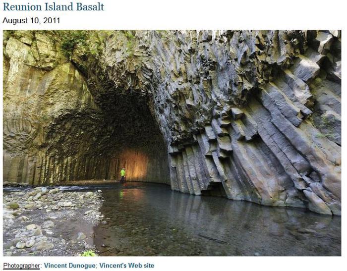
Réunion Island basalt. Photo from: http://epod.usra.edu/blog/2011/08/reunion-island-basalt.html. Photo taken July 14, 2011.
And now for a bit of temptation – one of my favorite holiday treats:
Fire and Ice Candy (a version of Peppermint Bark)
A tasty treat that has the bite of spicy Cinnamon candy blended with the smooth creaminess of white chocolate.
1 pound white chocolate, broken up
4 ounces any hard strong spicy cinnamon candy, broken (smashed) into pieces (in the US, think Red Hots).
Requires a double boiler, parchment paper, and a cookie sheet.
Cover cookie sheet with parchment paper. If you cannot get the paper, lightly grease the cookie sheet.
Get the water boiling in the bottom ½ of the boiler, then remove from the heat.
Melt the chocolate in the top half of the boiler, stir in candy.
Pour the mix onto the cookie sheet and spread very thin.
Cool until it hardens, then break up into bite-sized pieces and enjoy.
Note – Finding the cinnamon candy can be difficult, I get mine at a store that specializes in candy and cake fixings and utensils.
This can actually be made with any type of strongly flavored hard candy – peppermint, lemon, butterscotch…..
Fran
Since this post was written, there have been several further eruptions on the island. It averages about 1 eruption every 8 months (over the past 50 years), and by this measure beats Kilauea hands down. The eruption rate is 0.01 – 0.04 km3/yr, lower than Kilauea, but it does do large eruptions too: the one in May 2007 was comparable (within a factor of 2) to the Puna eruption. Perhaps French-speaking volcanoes do not get as much attention as they deserve. They are part of hot spot history.


This post needs a health warning! 😛
Dunno, the peppermint bark recipe seems easier than divinity. That stuff requires perfect timing and a bit of magic to get right. I literally trashed my kitchen one Christmas until my Mom rescued my efforts. It was passable, but only because of her skills. Kitchen alchemy is beyond me and you need a good bit of training before you can gain the skill set for candies and such. I do remember one Christmas season when she made rum balls for an office party where she worked. People left inebriated. As far as I know, alcohol was not served at the event. All I remember is that I was forbidden to even try them. (I was a teen)
Since this post was originally written piton has erupted 12 times… But all of those eruptions together probably only add up to 1/10 of the volume of kilaueas recent eruption, really shows the difference between the two.
It is also noticeable in the age of the islands. Reunion is 3 million years old and still dwarfed by Hawai’i, even though Hawai’i is ‘only’ 900,000 years old.
I think piton also has a very small magma chamber and might be equivalent to the start of the post shield stage of Hawaiian volcanoes, all of its recent lava is borderline ultramafic picrite basalt and it seems to do small frequent eruptions that rarely last more than a few weeks and have never lasted even as long as a year. It would be interesting to see if it was erupting tholeiite basalt before its recent caldera formation about 5000 years ago.
Reunion is definitely more evolved than Kilauea and is post-shield. The lava is still very fluid though. The shallow magma chamber is around 0.25 km3. The deeper region, with multiple dikes, is more similar to Hawaii. Piton does everything that Kilauea does, just smaller and more often. If you want to see pit craters develop, or multiple caldera collapses, Piton is the place to go.
In a way it could be more useful to compare dolemieu shield to pu’u o’o than to kilauea as a whole, it is almost the same size (it is a bit taller) and was collapsed by a rapid eruption at low elevation. I think 2007 dolemieu crater now is about what pu’u o’o will look like when its steeper sides collapse – a 500 meter wide pit crater, except pu’u o’o probably wont be seeing any lava for a good while, being a monogenetic flank vent.
It is really pretty strange that no eruptions have actually happened inside dolemieu crater since 2010, piton has clearly recovered from 2007 because it was able to erupt for 2 months at a decent rate in 2015 as well as erupting twice within a year before that and 7 times between then and now, but there is still a deep pit at the summit.
In the Canary Islands three cases have been studied of stratovolcanoes rapidly forming after large landslides in the three most active islands (La Palma, El Hierro and Tenerife). Piton de la Fournaise might be one of these volcanoes that is still recovering from the collapse, but instead of a stratovolcano you get a shield because of the fluid lavas, Dolomieu could have formed after the landslide that created Grand Brulé and I think probably also the Enclos Caldera. The landslide triggers descompression melt and an easier path to the surface and also means the volcano recovers flank stability (less rift zone activity) until it grows back to a large size and that would explain why activity is so centralized in Dolomieu and maybe also why eruptions are so small and frequent.
That makes a lot of sense, and likely has something to do with its markedly radial eruptions despite being an obviously rifted volcano but I think a lot of it is also to do with piton being on the decline. Even though it is probably the most frequently erupting basalt volcano on earth, it likely compares better to an older volcano in Hawaii, like hualalai or even mauna kea, better than it does to kilauea. Hualalai has only erupted twice in the past 250 years but those flows were very big so the amount of lava it has erupted in the past 250 years is likely to be comparable to piton de la fournaise, despite being about 100 times less active. This also goes pretty well with how old piton is, probably reaching sea level well over 200,000 years ago, at which point hualalai was also in its shield stage and rather bigger than now. This is also evident by only a few percent of both piton and hualalai being less than 1000 years old and piton having significant large scale erosion outside of enclos caldera, while 90% of kilauea is less than 1000 years old.
I think piton will probably last a long time the way it is now though, reunions plate is a lot slower than the one Hawaii is on so it can be much more long lived. Reunion was already an island when Oahu was in its shield stage, and piton des neiges was active for 2.5 million years before it died.
Apparently Hualalai has produced an average of 0.2 km³ of lava each century during the last 3000 years while Piton de la Fournaise has emitted more than 0.8 km³ between 1920 and 2002, so Piton de la Fournaise is more productive than Hualalai and clearly more than Mauna Kea. Piton is still far away from Kilauea but very few hotspot volcanoes at their climax will get close to the eruption rate of a hawaiian volcano during their shield building stage.
And also if Piton de la Fournaise was in its post-shield stage then the lava should be more evolved, Hualalai has even erupted trachytes while Piton erupts almost ultramafic lavas. Piton des Neiges also erupted trachytes, I assume that was during its last phases of activity. When Dolomieu overflows the Enclos Caldera then it will probably start filling some of those gullies.
What is your source for how much lava it has erupted? The only thing I could find is that 2007 was very big and significantly higher than any other eruption. GVP does say that a lot of its eruptions in the 20th century were exceeding 100 m3/s but given those flows are in the same size range and time as flows from this past few years I think they are being overestimated by an order of magnitude. 2007 was basically pitons grand finale, it likely isn’t capable of an eruption much bigger than that, and it emptied all of what little magma storage it has, and get it was still only about 0.2 km3. 2007 likely contributes a significant part of the total magma erupted in historical time, I would give the total magma piton has erupted in historical time to be about 2 km3 at most, about 1/10th of kilauea, which is also something found on actual study not just something I made up.
Piton is definitely past its golden age though. Like mauna loa it needs a way higher magma supply than it currently has to explain its size. It is probably erupting picrite basalt still because it has had a major collapse event in the recent geological past and so it still has no real magma chamber yet, but when that happens I doubt it has the supply needed to keep it from evolving before it is erupted so it could be more circumstantial that it appears younger. I was also comparing it to mauna kea because of its size and level of erosion, actually none of the big island volcanoes are as eroded as piton, not even kohala which is almost extinct. I think for it to fill in the valleys it needs a major change in the location of its main vent, and a big increase in supply, which might not be that likely.
Hualalai probably also has erupted way more than 0.2 km3 in its last eruptions. The huehue flow under Kona airport is wide and thick and flowed into the ocean over a wide area like the flow this year did, so it probably has a much bigger volume than is expected from its area. The other flow not so much because its ocean entries are smaller but it probably still has a pretty big volume given its size. Both are far larger than anything piton has done recently.
This is a different source but I can’t find the graph I used for my previous comment: https://academic.oup.com/petrology/article/38/2/171/1442890
In the geological overview it gives an estimation of 0.01 km³ of lava/year for the 1931-1985 period so it would equal to 1 km³ per century which is 5 times what Hualalai erupts. Individual eruptions of Hualalai may reach more than 0.2 km³ but as far as I know eruptions there usually happen a few centuries appart.
The article also concludes that Piton de la Fournaise is still on its shield-building phase, apparently the earlier lavas are alkalic but ∼350 ka ago the composition changed to tholeeitic and has remained like that until now. When compared to Hawaiian volcanoes Piton seems to still be in its shield building stage. The lavas erupted haven’t been much evolved (basalts and picrites) neither before nor after Enclos while it is typical for post-shield stage volcanoes to produce intermediate or felsic lavas, Piton des Neiges erupted trachytes. The reason why the west flanks of Piton are so eroded might be because the large landslide or landslides that formed the Enclos Caldera concentrated activity inside the landslide scarp and the rift zones became inactive. If Dolomieu keeps growing it will eventually overflow Enclos and the rift zones will become more active making the western flank look younger than it does now.
I do remember that for hawaiian volcanoes a sign of transition to the post shield stage is eruption of picrite basalt at a higher frequency, as well as a greater frequency of radial eruptions.
While it is true that piton has collapsed recently it still has entirely radial eruptions including directly at a right angle to the direction of the rift zones and faults inside the caldera, so I think if it is still on its shield stage it is probably on its last legs. It also erupts picrite that seems to spend no time inside any storage at all, usually it is actually inflating when it erupts so I think its magma supply at depth is constant but only sometimes has enough magma to rise up into the upper chamber to cause an eruption.
Also for hualalai I think it has the same problem as for kilauea, a lot of its recent eruptions volume probably went into the ocean. There doesn’t have to be a visible flow margin underwater for the flow to have significant underwater volume. I think HVO is probably underestimating the volumes of a lot of eruptions by a lot, if mauna ulu only had a volume of 0.23 km3 over 40 km2 of area covered by its lava it would be only 5 meters thick, while most of it is definitely way more than that, not to mention a lot of lava flowed into the sea.
The recent lava flow probably resembles the huehue flow from hualalai pretty well, and most notably is that if the new flow wasn’t observed it probably wouldn’t have been considered to be a voluminous entry because it likely would have been assumed it was emplaced over shallow shelf sea. We know this isn’t true because it was observed, and some of the new land was ocean over 300 meters deep only a few months ago, so it is quite plausible this is what also happened on hualalai in 1801, significantly increasing the size of the flow, I think it also buried one of Kamehameha I’s private fishing ponds but I’m not sure if that is confirmed. Hualalai probably erupted about 1 km3 total in its last two eruptions, which makes it less productive overall than piton, but pretty impressive for a volcano that only erupts a few times a millennium and most people probably think is extinct. Its kind of like the pinatubo of hawaii, it erupts infrequently but when it does it is go big or go home. I think it probably has a much bigger risk factor than mauna loa or kilauea, people know those two are active especially after this year, but hualalai has only barely erupted in historical time and it is poorly recorded.
It doesnt make much sense that a shield volcano entering its post-shield stage will start erupting picrite, Kilauea and Mauna Loa that are right now in their shield building stages sometimes erupt picrite basalt while post-shield volcanoes show more evolved lavas, mainly alkali basalts, trachyandesites and trachytes, like Haleakala, Mauna Kea or Hualalai.
Piton des Neiges also shows to have had a similar evolution, starting with a phase of basaltic eruptions that lasted for at least 1.5 million ending about 450000 years ago and then was followed by a phase trachytic explosive eruptions that continued until the last maniphestations of volcanic activity.
The reason why there is a very small area that is less than 1000 years old is because after the 4500 ya old Enclos flank collapse, activity has been limited to Dolomieu. But Dolomieu forming in 4500 years proves that Piton de la Fournaise is very active and probably still growing, give it a few tens of thousands of years and if no more flank collapses happen then most of the gullies will be no more.
I think it is more that the greater frequency of picrite erupting is because more of the magma bypasses the magma chamber, which can subsequently evolve. Also I think picrite and ‘alkali basalt’ are basically the same thing, except alkali basalt has more sodium and less magnesium. It is usually 50-45% SiO2 which is definitely not evolved.
I guess to know how much lava piton has really erupted we need to know how deep enclos was when it formed. It reached the water table but that doesn’t really help much because I dont think that is known with accuracy.
I still highly doubt is is even anywhere near comparable to kilauea, but then again neither is mauna loa through my calculations, despite its size and eruptive vigor. Piton is maybe somewhere at a point in its life similar to mauna loa, it is still very active but probably wont get a lot bigger than it already is, maybe only higher. I guess maybe it just isn’t that similar in its structure so it could have a different overall cycle with common elements.
Tholeeitic basalts can also be picritic, in fact Piton de la Fournaise lavas are slightly tholeeitic but are also enriched in olivine probably by intruding trough olivine cumulates in deep dikes which makes the basalt picritic aswell. Same goes for Kilauea, probably the picrite basalt eruptions like 1840 or Halekamahina were intrusions that travelled through the deep rift zone areas and picked up large amounts of olivine there.
I think when Piton de la Fournaise enters its post-shield stage it will do something similar to Piton des Neiges, the eruption rate will decrease and magma will evolve to trachyandesites and trachytes, explosive activity might also take place. But Piton de la Fournaise is still far from that, right now it has a rate of 1 km³ per century and that is enough to cover the whole shield in 1 m of lava each century, I am not sure of how much volume does erosion take away in that time nor isostatic subsidence but I think 1 m per century is enough to keep the volcano growing for now.
Actually a few weeks ago I was making maps of all the major events on kilauea starting with the caldera collapse around 1500. I included halekamahina in that event because of its picrite magma composition which seems similar to the leilani fissure of that year. I dont think I have ever seen an age for halekamahina except it is less than 600 years old because it is in the ‘P4O’ age area which is the same as the 490 BP flow and so there is a not small chance that it was formed in the same eruption possibly on a long fissure that has been partly buried by hu’u honuaula about 170 years later.
I think that picrite might also not be a foolproof indicator of a big deep intrusion. I would expect all deep intrusions to erupt picrite, but some shallower eruptions probably also erupt picrite. This is probably most apparent in 1960 because 1959 had recently charged the summit with picrite and some made it down the dike. the 490 BP flow was picrite but it doesnt seem to have damaged the system much like 1840 did because it reactivated almost immediately, much as it did in 1790. Mauna ulu also erupted some picrite towards the end of its high fountains.
The current eruption could also be borderline picritic, HVO said the lava was extremely hot even for kilauea and apparently was one of the highest lava temperatures ever recorded, and the 30 years of pu’u o’o erupting probably drained out all of the older magma in the chamber so it is likely that none of the magma in the open system was more than a decade old. Maybe on kilauea picrite just indicates a big pulse of new magma, rather than how it got to its eruption spot.
200 meter tall lava fountain during the 2007 eruption. Apparently there was an almost 300 meter tall fountain at one point, it coincided with the main collapse in dolemeiu crater.
Theres quite a lot of steam on the HVO webcam, its coming from the bottom of halemaumau.
It doesn’t look like there is steam coming from anywhere else but it is quite thick in the middle.
I think that is a pretty good sign of a lake being there, or that water is getting close to that area and will soon create a lake if one isn’t present yet. I saw a video where someone said one of the signs of the water table getting into the crater would be abundant steaming as the surface rocks cool enough for water to contact them.
We are visiting Reunion Island for the day as part of our cruise to Mauritius in October. 🙂
That’s lucky! Please send us your impressions on the place when you can, after your trip.
The mapping of the Kilauea ocean entry area is going on now.
Interesting that there do not appear to be any new features where the lava entry was. I guess it all got blasted into sand or washed away.
http://www.nautiluslive.org/
Some statistics for well known known basaltic volcanoes over the last ~260 years (since 1776 – historical time for hawaii which is the shortest so it is comparable). This is also just from memory so a lot of it is probably wrong, and there are also a lot of others (katla, askja and hekla for Iceland, pavlov in Alaska, klyuchevskaya group in Kamchatka (definitely large but not much available info), stromboli and vesuvius in Mediterranean Europe, erta ale in Ethiopia, fernandina, sierra negra, wolf and cerro azul in the Galapagos, pacaya, fuego and izalco in central america, ambrym in Vanuatu, kartharla, marion and heard in the indian ocean, to name a few… 🙂 ) that I dont have enough information on to compare here.
Piton de fa fournaise – 100+ eruptions – ~1 km3 of lava with 1/5 of that in 2007. Average eruption duration about 2 weeks, probably erupting for about a total of ~6 years over that period giving average effusion rate of only 0.5 m3/s but this is very variable with 2007 exceeding 100 m3/s and 2015 reaching 70 m3/s.
Etna – 100+ eruptions – ~3 km3 of lava. Average eruption duration about 3 months giving about 60 years of actual eruption, an average effusion rate of about 1.5 m3/s, but as always very variable and probably exceeding even 1000 m3/s during brief high fountains.
Kilauea – ~70 eruptions but two lasted 3 and 13 decades respectively – ~20 km3 of lava. Average eruption duration not applicable because of extreme outliers, but total time in eruption is about 160 years of that period giving an average effusion rate of 4 m3/s. This is very variable though, 2018 was around 200 m3/s, 1959, 1960 1969 and 1983 were probably over 500 m3/s and 1790 was probably over 1500 m3/s.
Mauna loa – 32 eruptions – ~7 km3 of lava. Average eruption duration about 1 month giving a total of about 3.5 years of eruption, and an average effusion rate of 45 m3/s… 1950 and 1868 were probably over 1000 m3/s at the start.
Bardarbunga – only one known large eruption, holuhraun in 2015. 1.8 km3 in 6 months with an average eruption rate of 141 m3/s. Eruption was probably 10 times as big as that at the start.
Grimsvotn – about 10 eruptions – 5 km3 of lava. About 3 years of eruption so an average of about the same as mauna loa. Adding the skaftar fires turns this into about 4 years of eruption with 23 km3 of lava though, making it by far the most powerful volcano in terms of total output, an average of 1400 m3/s. 2011 and 1783 probably exceeded 10,000 m3/s at their peak.
As can be seen, kilauea is by far the most active with about 70% of historical time being continuous activity, but with several much bigger eruptions. It is overtaken in average effusion rate by its neighbor and the icelandic volcanoes though, and grimsvotn takes all if you include the skaftar fires as part of grimsvotn proper which is debatable but Carl isn’t here so probably better not to get into that 😉
However skaftar fires was the first event from grimsvotn on that scale in a few thousand years, and 2011 sized eruptions are almost as rare, while historical activity on kilauea is pretty typical of its overall activity, so overall kilauea probably far outpaces grimsvotn. Both are rather significant outliers, reaching double digits in km3, an order of magnitude above reunion, bardarbunga and etna, and about twice that of mauna loa.
If anyone has more knowledge on other places it would be appreciated, I know a lot about hawaii but not so much about other places… 🙂
What about Erta Ale in Ethiopia?
I said that in the list of volcanoes I don’t have info on. I should have added nyamuragira and nyiragongo to that list too, and mt cameroon.
In any case though they are all dwarfed by kilauea, I guess all those collective 20+ years of continuously draining lava to the ocean between 1986 and 2017 really do add up in the long run, and seems to never be taken into account during eruption volume calculations. Grimsvotn technically is only king of the hill on that list because the skaftar fires happened during the time I covered. If I chose to start at 1790 instead, which is when GVP actually lists Hawaiian eruptions as historical, then grimsvotn suddenly loses its big hit and goes into 3rd place, giving Hawaii a solid landslide victory.
Klyuchevskoy, tolbachik, nyiragongo and nyamuragira probably exceed piton and etna and are probably only a bit short of mauna loa, but it is difficult to find any actual information on how big their eruptions are, except nyiragongo 1977 had a peak effusion rate of 10,000 m3 a second, but only for less than an hour before the eruption stopped.
I was watching the NautilusLive feed as they were mapping the F8 / Kapoho ocean entry area earlier this week and, to me, it appeared that there was almost no change to the seafloor offshore. Same and/or very similar depth and no hint of a new bench or ridge offshore where the sometimes very large ocean entry lava flow hit the water. It really does look like the vast majority of everything that hit the ocean got pulverized into sand or just washed away. I agree with you, there appears to be a good case to be made that actual eruption volume is/was/are potentially much larger when lava hits the ocean. In the case of Hawaii, if even 10% of the erupted magma directly met ocean over the last million years, that adds up. No way to know, however.
One potentially interesting exercise would be to compare the estimated total volume of the F8 output with the amount of lava volume that covered existing land plus the amount that filled in to create the new land. Whatever is leftover just poured into the ocean and looks to me like it mostly made sand and or washed out to sea.
Or you could estimate it as a prism that is triangular with a face area of about 7 km2 and depth of 300 meters. That would give a volume of about 150 million m3 just for the amount of lava below sea level off between pohoiki and cape kumukahi.
Assuming the eruption average effusion rate was 150 m3/s because this is what HVO gives (it was probably as much as twice this during surges and from fissure 22 though) then that rate for 77 days (May 18 – Aug 3) gives a volume of ~1 km3, so there is about 0.85 km3 on land. This is slightly more than the volume of the new caldera, so some collapse on the rift has theoretically occurred, probably through pu’u o’o.
In theory, with an average supply rate of about 10 m3/s an extra 66 million m3 of lava was added to the summit, probably about the same as the difference between the caldera and eruption volume. In the past 29 days since the eruption stopped there has also been 25 million m3 added to the system in theory, however I think it is so drained that it will take a long time to show any real inflation even if a lot of magma is accumulated. Alternatively an eruption could just happen without inflation as the ring faults could be easier pathways than pushing up the plug.
I think there is going to be a record landslide victory for Erik’s Pliny award this year…
This decade (2010-2020) really should be remembered as a big decade in volcanic activity, ~10 km3 of basalt lava has been erupted from terrestrial volcanoes, (half from kilauea alone), and the thermal energy of that cooling to room temperature adds up to a borderline VEI 8… 1991 might have had two VEI 6s but even combined both of them are dwarfed by the thermal energy of kilaueas eruption this year on its own, let alone the equally big flow on sierra negra and the significantly bigger eruptions in Iceland. Calling a double VEI 6 small in comparison really isn’t something that can be said very often, not to mention kilauea, famous for its accessibility and ‘safe’ gentle eruptions, now has a very real chance of having the next VEI 4-5… Someone (who was definitely not me 😉 ) once asked what grimsvotn would look like if there was never any ice, I can say now that it would look like kilauea.
The Deccan Traps ”Superplume” event must have been an amazing sight. Some individual lava flows in the flood basalt sequnce are 50 m thick and 1500 kilometers long. I imagines curtains of fire along 200 km long fissures with huge fountains all along. Massive pyrocumulus convection near the traps vents. Huge open thin crusted channels hunderds of km long and huge ponds of lava 150 m deep near the vents with real waves crashing over.
Flood basalt basalt flows are massive and uniform and thick suggesting rapid emplacement and high flow rates. Makes Holuhraun and Laki look like a little fart.
You probably saw this in the original comment already but at the peak of the Deccan traps (and which also happens over the KPg boundary…) the magma supply rate was 60 km3 a year, meaning it would be a theoretical eruption rate almost as high as the peak of grimsvotn 2011 if it was all focussed into one area. It wasn’t, but even still it would only take a few decades for those massive continent wide flows to be recovered…
In this scenario I think Carl’s theory on how the skaftar fires worked is very applicable. In other massive flood basalts it probably was long dikes within the crust, but during the height of the Deccan it really seems like the most straightforward idea is for the fissures to be basically long ruptures that go right through the continent into the mantle. When every 100 km2 of the entire plume head has the same magma supply as Iceland and Hawaii combined I think that the most simple method of eruption is the most likely… It is surprising that India didn’t fragment under all this, the crust must be really solid and old.
The dinosaurs were lucky an asteroid did them in, their lungs might have been better than ours at absorbing oxygen which is why they got so big and birds took over the sky despite bats being better and more durable fliers, but those continuously circulating lungs that extend into the skeleton also significantly amplify the effects of toxic gasses, SO2 is way more scary to dinosaurs than it is to us (and that is saying something) and to make things worse the Deccan traps happened in the tropics so it would be like the effects of laki but over twice as bad, worldwide, and without a break for 30,000 years… The chixulub meteor did the dinos a favour by ending it quickly, otherwise basically all of them would have died out anyway but by slowly being poisoned… Maybe a few non-neornithine dinosaurs would have gotten through in the Americas far from the eruptions, but if the asteroid missed and the impact never occurred, the world would not be like a modern day Jurassic, in fact it would be basically the same as it is now except maybe a few million years behind and some birds might have teeth… 😉
The hurricane/tropical storm had little effect on the eruption aside from minor rockfalls at the summit and increased steaming from Puʻu ʻŌʻō and LERZ vents;
Interesting article on how the alps are tumbling down with the melting of permafrost https://www.summitpost.org/the-fall-of-the-alps/794108
OT lost an old friend to a heart attack today…. She had called me at 9:30 and said..”I’ve been thinking of you and thought… why don’t i just call her; so i did.” …. i said… “i’m so tired right now… i’ll call You later.” She died before i called her back……………..
Sorry to hear that. Reminds me of when Konrad was killed in a scooter accident in Phuket. I had been chatting with him online a few days prior.
(Survived the tsunami and died two years later)
Very sorry to hear. That is heart breaking. Life is a story of the unexpected, sometimes good, sometimes difficult. Keep well.
Thank You, i think the take away is: Sometimes in life we fail…… we need to forgive others when they fail us. ….
When I called my friend her landline was on the fritz, (Virginia)
she spent 3 days in the hospital and passed, I miss her and our talks but never look back or say what if I tried her cell or her husbands cell,
who would have thought she would go septic, Just live life to the fullest, your friend would like that, hugs.
Fantastic time lapse of the Kilauea collapse, produced (of course) by USGS/HVO
https://volcanoes.usgs.gov/observatories/hvo/multimedia_uploads/multimediaFile-2606.mp4
Still no mention of a lake though, maybe they aren’t allowed to fly yet so they cant get a look into the crater.
I guess even if the lake is 90-100 meters deep it is probably still out of view. The bottom is 500 meters below the edge of the pit to the southwest and 600 meters lower than the observatory, as well as about 300 meters lower than the edge closest to the observatory. HVO will probably do an overflight soon.
Probably trying to keep it secret so no one finds out its the best fishing spot on the planet. It’s a conspiracy among the geological ellite.
😀
Not sharkanos again.
I never was a shark(whatever) fan. I even purposely avoided the movie “Meg” which had a more plausible backstory. (If you can believe a Megalodon could exist in such cold water) I’m not overly impressed by movie hype. Now something like Heart Mountain, yeah, that gets my interest.
“…was probably originally about 4–5 kilometers thick. Although the slope was less than 2 degrees, the front of the landslide traveled at least 25 miles (40 km) and the slide mass ended up covering over 1,300 square miles
…
The consensus favors catastrophic sliding and calculations suggest that the front of the sliding mass may have advanced at a speed of over 100 miles/hour (160 km/h), meaning that the mountain traveled to its present location in approximately 30 minutes.”
The spooky bit? This is likely the most plausible explanation for how it got there.
As for the sharks, just don’t go where you are not the apex predator.
Actually megs could probably tolerate cold water just fine, all lamniformes are very cold tolerant sharks. Megalodon was part of the Otodontidae (It is either Carcharocles megalodon or Otodus megalodon). One of these sharks, Cretolamna is known from very good material (I think at least 10 fossils that arent teeth) and existed from 130 million years ago until only 5 million years ago, and on the way it appears to have evolved into all of the other otodontids as well as the modern lamnid sharks. It looked very similar to the modern porbeagle shark which means it was probably very fast and active. Meg probably inherited this relatively high metabolism. Even more than that though, is the simple fact that it was absolutely massive, so I think the idea of it being taken out by cold alone is pretty unlikely.
The extinction of megalodon was part of a much more significant extinction. About 30% of marine life, most of it large endothermic predators like toothed whales and big sharks, went extinct at the start of the Pleistocene. Of all the big predatory whales alive at that time only the sperm whale survived because it specialized. For most of the time since the mid cretaceous (and all of the cenozoic) there have been 9-11 meter giant carnivorous sharks, but when meg went extinct that was ended and so far there hasn’t been a replacement. This is a much needed area of study.
I guess this was a very long way of saying meg probably would have been fine in cold water… lol
Perhaps they dont concider it large and permanent enough to be noteworthy?
The amount of water that fell into only halemaumau on its own is enough to make a lake about 90 meters deep, I think that is a pretty major lake. If instead the water was boiled, then it would have cooled the rock down, making it easier for groundwater to enter the vent and so it is likely to exist either way.
The continued presence of steaming in the caldera is a sign of a hot lake existing, or groundwater reaching the surface.
New USGS video shows that the interior of the crater is dry. If a lake formed, it has drained by now. Which raises the question, where did the water go?
I guess it was absorbed into the ground and probably evaporated, but that would have cooled down the rock a lot so it will probably cool down enough to flood anyway in the near future.
One of the webcams. I can’t see any lake, but it does look like there might be a small stream down there.
That is because the lake will be in in the deeper part which is out of view to the right.
Lava finally stopped draining. No incandescence at F8. Maybe this is the last time lava will be seen erupting at Kilauea for a while….. And now officially there are no erupting volcanoes in US territory. That’s quite rare!
There has now been 3 days with no incandescent surface rocks on kilauea, that is the longest in my lifetime… 😉
That being said, if it hasn’t erupted by the end of next year then I will eat my hat that I dont have. If it is anything like the past 2 times this has happened then it is a really REALLY bad idea to open up the park too. If kilauea does a really high fountaining eruption like 1500 or 1790 then that is going to be the closest thing we have to an Icelandic dead zone fissure eruption until a real one of those actually happens. It would be like 1959 on steroids, eruption rates of 10,000 m3/s or maybe even more, enough to flash boil a 90 meter deep crater lake in seconds and turn it into a few km3 of steam. That could do an explosion on the megaton scale…
Intense fountaining lava eruption with probably very short warning and preceded by an almost castle bravo-sized explosion, sounds eerily similar to a certain Icelandic volcano… doesn’t it…
Not a storm yet, but it’s the best thing a Cape Verde storm can do, turn early and head for the open sea.
And apparently the ECMF model is confused. I don’t think storms are known to teleport very often.
Not as confused as the XTRP model
I think XTRP is just a DR of the storms current course and speed. I’ve seen it before in other storms and that is usually what it equates to, and is always a straight track with no turns. As for funky models, the TAB series is usually a hoot. Especially TABC when they show it.
For all, those tracks in the plot are just the results of various computer models for the storms motion. When they line up in agreement, you have a good chance of the storm actually following it. Usually NHC will fold the models into an average and make a few educated guesses about the storms environment and then release that as their official projected track. It’s when the models point all over the place that things get hairy since you don’t really know which of the models are the most correct.
BTW, that dotted box between 60W and 65W is the eastern Hebert Box. Storms that threaten South Florida tend to track into or very close to one of those boxes on the way there.
“Hebert himself acknowledged that the boxes are not a guarantee of hurricane landfall either way, but cautions that if a hurricane passes through one, “really, really pay attention.”
XTRP -> Extrapolated (from current course and speed)
You could even say it is an eXTRaPolation.
Is something supposed to start brewing in the Gulf, lots of rain?
Mainly just rain. The closest tropical wave is plowing across the Yukatan and the top part of it is skirting the southern GOM/Bay of Campeche area, but no one has placed a probability of development area on it. Right now the big Atlantic Basin thing is a Cape Verde storm that is beginning to show development. That the models are showing a steady turn north is a good thing. Long track Cape Verde systems can be really nasty and well organized by the time they get to the Caribbean/GOM area and no one needs that. September is almost here and that is historically the most active part of the season.
From Mikes Weather Page (Spaghetti Models)
Thank you very much!
The space station has been punctured. The news calls it a ‘micro leak’ which required duct tape. It will be interesting to see whether it was a meteorite or human-made debris.
Perhaps we are fortunate it didn’t puncture one of the crew as well, these things move FAST But repaired with duct tape??? Not so much 2001, more Red Dwarf
They didn’t call it duct tape, but it sounded like it. It is in the Soyuz module, so it will be discarded anyway. No need for long lasting repairs.
At least an astronaut was able to have a hand in dealing with the problem.
New Horizons is just about to get within 1 AU of its next target, a binary plutoid (and that is not a disease). It should get there by the end of the year. It will get so close it is almost scary.
http://pluto.jhuapl.edu/whereisnh/overview/nhov20180801_0732.svg
Yea! Duct tape! it is also great for corns and other feet problems….. just cover with duct tape and see what happens… i’ve removed corns and relieved pressure points. just sharing…. Best!motsfo
Despite the apparent redneck method of repair, remember that “duct tape” technology has progressed quite a bit. “200 mph speed tape” is used quite often in NASCAR.
New post is up. Volcanoes and the smell of garlic
https://www.volcanocafe.org/the-air-we-breathing-the-sulfur-smell-of-volcanoes/