On 15 July, a video of an explosive eruption of Erta Ale (Afar Region, Ethiopia) volcano was briefly discussed in the comment section. It was a small ash plume emerging from the summit of the Ethiopian lava lake volcano. It was an unusual development, and some of us had already commented on the possibility that Erta Ale was collapsing. I was divided between a collapse and simply a side of the crater falling into the lava lake, which is known to yield an explosive result. In truth, the second option wasn’t possible, as there was no actual lava lake, but rather an active spatter cone at the time. I must have been neglecting our beloved volcanoes because I didn’t give much thought to it, not even when chad commented on the thermal signature of what could be an intense eruption, only to be surprised on Wednesday by jbean sharing some interferograms and satellite images that showed a 35-km long dike intrusion (a giant underground blade of magma that creates new ocean crust), plus a fissure eruption running towards nearby Hayli Gubbi volcano and the northern side of the caldera sunk into a pit crater!

Deformation map of the dike intrusion (the red triangles are Erta Ale and Hayli Gubbi, and the blue area is Lake Afrera. Deflation of a dike body under the summit of Ertha Ale can be seen, plus intrusion of a massive dike down into the salt plain of Lake Afrera (where ground fractures have been observed). From COMET report: https://comet.nerc.ac.uk/wp-content/uploads/2025/07/COMET_EventReport1.1_ErtaAle.pdf
A 35-km-long dike is no joke. In the 21st century that I can recall, the only dike intrusions that have reached this size have been the Manda Hararo dike of 2005 (Ethiopia), the Bárðarbunga dike of 2014, and the Fentale dike of December 2024 (Ethiopia). There have surely been many similarly sized intrusions in mid-ocean ridges; in fact, I know a bunch that have taken place in slow mid-ocean ridges, from the prodigious seismic swarms they sourced. Surprisingly, there have been no earthquakes detected on the USGS earthquake catalogue, unlike other dike intrusions on this scale.

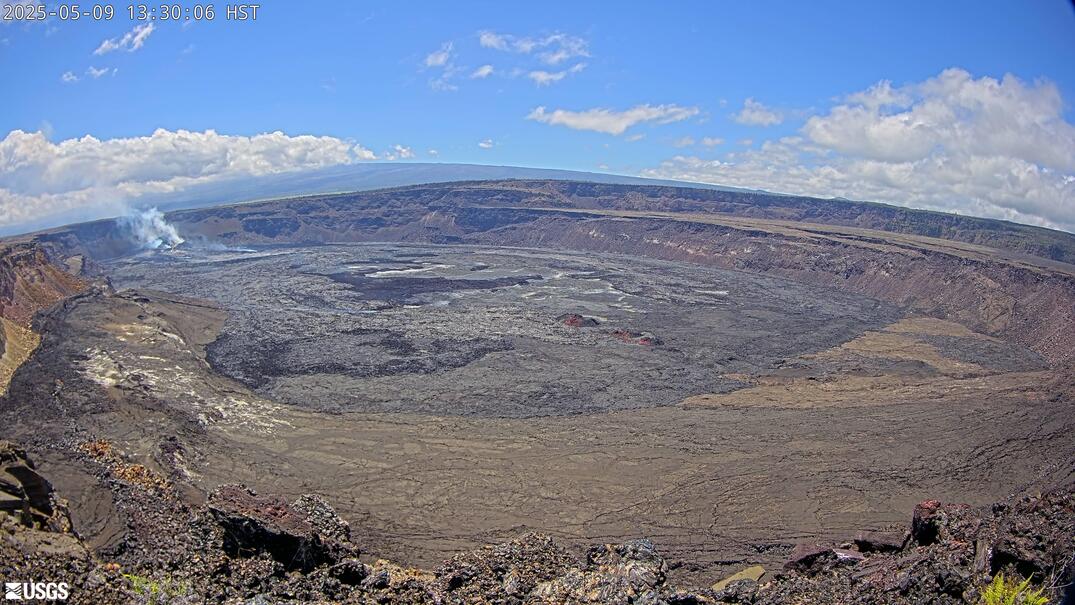
Erta Ale is THE lava lake volcano by excellence; its eruption history reveals no evidence of fissure eruptions producing fountains, which means that a lava lake or similar open conduit has always existed at its summit, keeping the system degassed. Here is a view of said lava lake; the walls show narrow lava layers formed in repeated overflows. The extraordinary fluidity can be noticed in how thin the overlapping sheets of lava are, and also in the metallic shine of the lake’s crust and the fluid bubbling playing on it. The gas-poor nature of tholeiite basalt is responsible for the peaceful behaviour of the lava. From Hervé Sthioul: https://commons.wikimedia.org/wiki/Category:Erta_Ale#/media/File:Erta-ale_lac-de-lave_2001.jpg
The course of events
The current events started on July 15, with videos of an ash column emanating from the north pit of Erta Ale. Same day, the MODVOLC tool of Hawaii University (NASA funded) recorded a remarkable radiant heat signature of 1800 MW, the strongest since the fissure eruption in 2017. The signature came from a fissure that opened intermittently over a length of 5 km between the southern caldera of Erta Ale and the base of the cone of Hayli Gubbi volcano. The ash emanating from the summit of Erta came from a similar mechanism to the collapse of Kilauea in 2018; the retreating magma column emits jets of magmatic gas through the collapsing crater, which produces a cloud of ash. Luckily, the explosions weren’t too violent since some people were apparently near the rim of the caldera at times, well inside the reach of flying blocks of rock had this been like the collapse of Kilauea in 1924. The collapsing crater was due to the removal of a large amount of magma from Erta’s summit storage by a growing dike intrusion.

Fissure eruption ongoing on the 16th as captured by Sentinel data. The lava front is still advancing. A bluish volcanic gas plume rises from the summit of Erta Ale, shrouded in clouds near the top of the image. Bluish gas also rises from the fissures and possibly from the summit of Hayli Gubbi. One aa lava front is still advancing, but the eruption seems largely over.

Ash fallout deposit produced by the collapse of the northern pit crater of Erta Ale, now a gaping hole 400 meters wide. The southern crater has also seen a small collapse.
The eruption did not last, nor was it particularly large. The reason is probably that Hayli Gubbi snapped next, and a much deeper dike emerged from this neighbouring volcano (as visible in the deformation maps shared over social media), reaching 20 km southward to the salt plains of the Lake Afrera basin. This massive dike must have enormously reduced the pressure in the dike section between Erta Ale and Hayli Gubbi, shutting off the fissure eruption immediately. This interesting thing here is why the dike became much deeper starting from Hayli Gubbi southward. The reason for this, I believe, reveals the underlying plumbing between these two volcanoes, and this couldn’t be more interesting.
A dike intrusion has the job of filling the plate boundary where slow, continuous filling is not possible, and instead, brittle failure is required. If the behaviour is anything like Hawaiian volcanoes, then the plate opening below 2 km is accommodated by a slowly expanding magma body (a sort of perpetual dike). The reason for the shallow segment (I believe) is that magma is present at ~2 km depth running from Erta Ale to Hayli Gubbi over a length of ~12 km, thus absorbing continuous spreading; beyond this location, magma is likely much deeper, so the dike also had to become deeper to accommodate the plate opening. This is cool cause it means Erta Ale and Hayli Gubbi are connected at a very shallow depth. This is not really unprecedented, and two volcanoes in the northern Erta Ale range, Alu and Dalafilla, are merged into a singular 10 km long laccolith complex at a similarly shallow depth, which was confirmed when both deflated simultaneously in the 2008 Dalafilla eruption.
Is a full caldera collapse possible? The circumcaldera flow of Erta Ale.
A lateral intrusion this big is more than capable of collapsing a volcano, so a caldera collapse is possible. I think if there’s a suitable magma chamber, a new caldera is guaranteed. The only problem with this is that there might not be one. The last time Erta collapsed was only centuries ago (based on the youthfulness of lavas cut by the collapse); the summit sill complex may not have had time to reassemble into a single magma body since then.

The northern caldera of Erta Ale volcano is seen from the south. Pre-caldera lavas are brown colored due to fumarolic emissions that frequently blow from the central craters. The caldera is floored by young lavas coming from the two long-lived vents inside the caldera, the south and north pit craters. Lavas in the foreground that extend outside the rim are from overflows from 1974-1974, the last flows outside the caldera before the eruption in 2017. Photo from Luigi Cantamessa: https://volcano.si.edu/gallery/ShowImage.cfm?photo=GVP-00120
The volcano possesses two calderas, both elongated along the rift in a manner reminiscent of a Hawaiian volcano, particularly like Mauna Loa. The northern caldera is smaller, 2 km by 1 km in size, with two pit craters inside the north and south pit craters, which often have active lava lakes or spatter cones. The north pit of the north caldera seems to be the absolute summit of the volcano. Another larger caldera lies to the south, 3.5 km long and 2 km wide. The southern caldera is surrounded by what might be the most unique lava flow I’ve ever seen. This “circumcaldera” floor is extraordinary; it resembles a wave of molten aluminum issuing in every direction around the southern side of the caldera, overtopping obstacles, draping every corner in a sheet of lava, reaching 3 km away while maintaining a sheet pahoehoe morphology that is highly unusual over such long distances and steep slopes. I think this flow is a unique example of a degassed basaltic ignimbrite. When the caldera collapsed (maybe from rifting), it triggered the ring fault of the collapsing structure to be intruded and gush out as lava all along the rim. This did not last long, due to the collapse being very shallow or the lava quickly becoming trapped inside the deepening crater, but nonetheless must have been quite intense.

Map showing the calderas of Erta Ale and Hayli Gubbi, plus the extent of the unusual circumcaldera flow where not covered by younger lava.

Section of the outer flank of the southern caldera showing the circumcaldera flow. The lava is sheet pahoehoe with braided streams of aa inside, and seems to mantle topographic obstacles and ridges.
Fentale, Afar, and what might come out of this situation
As I mentioned in my Fentale articles, I already expected that volcanism would probably spread to other volcanoes in the region, like the 2005-2013 activity across Afar, the Red Sea, and Arabia, which involved Dabbahu, Manda Hararo, Nabro, Dalafilla, Zubair, Jebel at Tair, and Harrat Lunayyir volcanoes. This is part of why I was eager to write about Ethiopian volcanoes. In the end, the activity did not come from some volcano no one has heard about, but from the most prominent volcano of Ethiopia as a whole. Regardless of what happens, I think that a lot can be learnt about how a cluster of volcanoes interacts on a regional scale from the ongoing situation, not just from additional dikes or eruptions but also from how volcanoes across Ethiopia may change deformation patterns, with particular emphasis on the laccolith of Alu-Dalafilla, and the Main Ethiopian Rift calderas.
Apart from the possibilities that Fentale might produce additional dike intrusions or a silicic eruption from the caldera, it’s now likely that Erta Ale will be very active in the years to come. At the very least, Erta will try to quickly fill the new hole in the northern side of the caldera with overflows. But likely, Erta Ale or Hayli Gubbi will try to send new dikes into the 30 km rifted section, which could result in long-lasting effusive eruptions, or finish the job by unclamping the north rift of Erta Ale too. And at the most, once the magma extraction from the asthenosphere is set in motion, it might bounce to other volcanoes in the area, particularly the neighbouring Alayta and Alu-Dalafilla that are very frequent eruptors; or Dama Ali and Alid, that should rift sometime soon.
I will get to write an article about the eruption history of Erta Ale, to publish soon, and provide background into this incredible volcanic system.


Comet just released a report with higher-resolution data than what I can make. https://comet.nerc.ac.uk/wp-content/uploads/2025/07/COMET_EventReport1.1_ErtaAle.pdf
I think these circumcaldera lava flows would look similar to the 1823 eruption of Kīlauea on the southwest rift zone.
https://www.google.com/url?sa=t&source=web&rct=j&opi=89978449&url=https://www.usgs.gov/publications/rapid-emplacement-keaiwa-lava-flow-1823-great-crack-southwest-rift-zone-kilauea&ved=2ahUKEwjU2__dvdiOAxW1OkQIHVGlAyUQFnoECBUQAQ&usg=AOvVaw0bPKSb8J55X14y7-6slbeO
It is quite unusual that, like the circumcaldera flows, overtopped a few cones down slope and was quick.
Maybe the “ignimbrite” eruption was like this, but many times bigger and more intense…
Yes, they are quite similar, and I’d have considered a similar mechanism if it weren’t for the circumcaldera flow covering the outer caldera flank so perfectly (like it issued from it).
I do agree, it seems the fissures from 1823 were made by the passive draining of Kīlauea’s lava lake back then, whereas these are just issued. It might have to do with purely fluid dynamics, rather than something more commonly gas-driven. Maybe like, as the caldera formed (as a few large blocks, maybe singular), it began to push on the magma chamber, forcing it out via pressure and pushed the magma out.
That is exactly how an ignimbrite forms, except an ignimbrite is usually gassy enough that the lava froths up or explodes once on the surface.
I have kind of always imagines an ignimbrite like the emephants toothpaste experiment, eruption of foam but the foam keeps expanding after it is erupted too, so there is a force of acceleration acting on it that is isnt just gravity.
To be honest, I think actually the viscosity of the magma is almost entirely irrelevant for ignimbrites caused by caldera collapse, its only the gas pressure potential. If anything VEI 8s are viscous because that makes it HARDER to erupt that way unless it all collapses. Most supervolcanoes are friendly giants when not proving themselves, and fluid volcanoes are a lot more explosive than expected.
https://youtu.be/1EEMfYU-KeU?si=dbvl3zyj2zWK6W3j
This is basically it, elephants toothpaste record. The video is a bit cringe but the vusuals are the only important part. Also, pure oxygen mixed with soap, which is mostly organic, might have been an explosion hazard…
I think that is just the way a fluid lava behaves when there is really high flow rate and volume locally. It isnt seen in most actually big effusive eruptions because they last too long, this is a product of extreme intensity and short duration.
Lava lake drainouts are classic, look at Nyiragongo 2021 lava, or the August 2011 lava breakout from Pu’u O’o, pahoehoe that has streaks of a’a in the center as the cooling lava moves. It also happens from curtains of fire fissure eruptions on a slope, Kilauea in 1974, Mauna Loa in basically every eruption, and at Svartsengi in recent years. Its basically any situation of a very intense but also very short lived effusive eruption.
Eruptions like Laki dont do it because they last a long time. The start of Laki was very comparable, and it was always very high in veneral, but the average rate over the shole eruption was much too low in comparison, 700 m3/s compared to thousands, or even tens of thousands, of m3/s that these intense eruptions give. Long lived eruptions create complex flow fields and new terrain regardless of how much lava is erupted per day.
I wonder what the flows of traps volcanoes looked like. I have seen claims for both extremely fast and also slower long lived flow emplacement. If comparing to probably the closest active analogy in Hawaii, Iceland, the reality is both options probably happened, but the biggest flows were erupted fast. In any case at that point the lava will be flowing a very long way and the majority of the flow field is going to be beyond the reach of later parts of the eruption, so it might well have a similar appearance to the lava lake drainout flows. Although, it might not scale up so neatly either…
Thanks for this, EA is one volcano that I hope to visit before I cannot. I look forward to the upcoming detailed article on this most interesting volcano. Cheers!
The whole Erta Ale range is basically like a long fissure volcano, not exactly but I wouldnt be surprised if they all share a common source. Whether that makes it a single volcano maybe is debatable, but the boundaries have been blurred this week.
If the larger dike is from Hayli Gubbi, maybe that is actually where a caldera could form. The fissure eruption and collapse at Erta Ale look like another go at what happened in 2017, but set off something else instead. Its nit inconcievable the southern caldera of Erta Ale was another lost shield volcano in the group, and that it is about to be joined. The area is harsh but not actually that remote, if anything is happening it will be obvious soon enough. As in GeologyHubs last video on it, theres 4000 people right next to it in Afdera.
“the southern caldera of Erta Ale was another lost shield volcano in the group”.
I have considered that the southern caldera could be the remnant of the pre-Holocene Erta Ale volcano, because most of the oldest exposures of the volcano are downslope from it to the east. Whereas the northern caldera shield is the newer Holocene construction, but this is difficult to determine.
The eruption at Sundhnjukur looks stronger now than a few days ago, at least it is fountaining higher at times from pictures I have seen, and the glow is brighter. It might be episodic, which is exiting as that was a sign of longevity in 2021. I dont think there are any lava shields on Sundhnjukur, but the eruptions in March and May last year did build a pretty high spot and the rifting in April might have significantly increased the volume of magma under the north end, which at Kilauea is probably why Pu’u O’o and Mauna Ulu formed where they did, in the middle of what was at the time a rifted area that filled with magma for years. That makes an easy option to flow if it is still hot enough, and the eruption was a bit slower and far north compared to the rapid starts in 2024, so this probably is the case.
Or it stops this week, but chances are this might be going for a while, and if magma supply is high and the path open theres no reason it cant be like 2021 really. The small volume erupted at Svartsengi in the last cycle might have only been because that cycle started at Brennisteinsfjoll, but this time is started further west, the volume might well end up much larger than last time, over 1 km3 or more. Just a thought, because its already bigger than last time and no sign of slowing down…
If this is the case, Grindavik probably got very lucky that it has focused north, it will probably survive.
The last real Sundhnukur eruption lasted for 18 days (Nov-Dec 2024). The current eruption has continued for eight days now. So it still may go for eight-nine days until around 5th August. 18 days was also the duration of Fagradalsfjall II 2022. Maybe this is kind of average for episodes, when the Fires have been established after the initial more variable eruptions.
It looks like it might have finished now, actually…
Isak is streaming rn, there’s still a decent amount of activity. The southern vent within the cone also seems to be reactivating at times with high bursts, at least thats what it did yesterday.
How high has the cone grown now? It looks impressive high now for the short time of eruption: https://www.youtube.com/watch?v=8bfcTBLvPiM
I’d estimate it’s 50-100m. Monte Nuovo grew faster. It did 140m within eight days.
looks slightly higher than the august one…so maybe 40-50m
I’ve just seen about three people wandering around near the cone, who walked off into an area that quickly got covered in dense smoke. It’s cleared a bit now, and I can see them near the front now where the lava exits.
(AfarTV Cam B).
It’s changed towards a great smoker now: https://www.youtube.com/watch?v=Pi8wg2QYZbU
That may mean the fun is ending
The cone has got a small flank vent. A dwarf and weak version of Etna’s deep flank eruptions. So the eruption continues somehow, but the strong steam/gas plume causes a bad webcam view.
Thank-you for this quick study on Erta Ale and Hayli Gubbi, Hector!
To me the shap of the intial ash cloud looked much like Pu’u O’o’s ash cloud 2018 during the collapse, but more grey. Pu’u O’o had a red ash cloud from oxidized basalt. Erta Ale either had layers of old basalt protected against oxidation or a source of fresh magma for the tephra cloud.
I didn’t see that the mega intrusions of Erta Ale and Hayli Gubbi are chronologically close to the mega intrusion of Fentale in December 2024. Is this a chain reaction or a swarm eruption? Does one event cause the next one like along a slide fastener or is there a general regional wave of tectonical-volcanic movement?
Fentale and Erta Ale are not on the same line, but Fentale is on the SW “African” wing of the Afar Triangle, while Erta Ale is on the NW (along Red Sea) wing. The direct distance between the volcanoes is ~600km, but if we follow the Triangle vor Djibouti, then we get to ~1200km. Did a chain reaction run from Fentale through Djibouti or is the whole Triangle going towards a swarm eruption mode?
As far as I have checked there weren’t significant earthquakes in Eritrea and Djibouti. If there was a chain reaction, it happened probably mainly aseismic.
This map with Ethiopia’s volcanoes show how they run towards Djibouti, where the center of the Triangle is: https://earthquakes.volcanodiscovery.com/map/Ethiopia
Erta Ale and Hayli Gubbi lie on the same volcanic structure. They look like two vents of the long volcano that stretches from Hayli Gubbi to Gada Ale (and Lake Karum). They are in fact part of the greater Erta Ale Rang: https://en.wikipedia.org/wiki/Erta_Ale_Range
The Erta Ale Range is a long volcanic structure comparable to Mauna Loa, but with several volcanoes. In the center of the Range is Borale Ale that has no record of Holocene eruptions. The highest volcano is Ale Bagu SW of Erta Ale, also without known Holocene eruptions. Google Maps satellite image shows that Hayli Gubbi did eruptions on the south end of the Range towards hypersaline Lake Afrera. Lake Afrera is in a “sandwich” position between Erta Ale Range, Tat Ali and Mount Alayta.
“I didn’t see that the mega intrusions of Erta Ale and Hayli Gubbi are chronologically close to the mega intrusion of Fentale in December 2024.”
If it was only that it could be coincidental. But it’s the precedent of the 2005-2013 events that makes it likely a regional interaction exists.
Between 2005 and 2010, the Manda Hararo dike intrusions occurred, which is still likely the largest rifting event we’ve ever witnessed. It is remarkable how much activity took place in Afar during those years and the few that followed. The Red Sea volcanoes that had been dormant for over a century (and are well monitored by passing ships) erupted three times, sizable eruptions that formed two new islands and a vast field of pahoehoe lava. Nabro woke up in 2011, producing the largest explosive eruption of Afar (and Africa) since Dubbi in 1861. Harrat Lunayyir came close to breaking a several-century-long dormancy of the Arabian volcanoes with a major dike in 2009. Alu Dalafilla erupted in 2008, which isn’t so unusual but still broke a decades-long quiet of sizable fissure eruptions in the Danakil Depression. While the mechanism may be up for debate, all of that happening in such a short time is very unlikely to be coincidental.
Shouldn’t we see a more significant participation of the central Afar region (Djibouti and Eritrea) in the activity? This region could work as a mediator between the arms of the Triangle.
Are the eruption swarms in the Afar Triangle comparable to the Fires in Iceland? Maybe they then the Afar Triangle can explain why Snaesfjell’s volcanoes often are active during periods of Reykjanes activity.
1906 when Erta Ale last did an explosive eruption (with or without an intrusion like now?), one year later Mount Alayta erupted with a large lava flow, explosions, property damage and fatalities.
Here was a discussion in the comments Google found in VC 2018: https://www.volcanocafe.org/signs-and-portents-of-iceland-revisited/
Is Thedustdevil still in Volcano Cafe? He compared the 1907 Alayta eruption to the Kilauea eruption 2018. 1907 the massive lava eruption was probably on a low fissure zone of Alayta. It is something that Hayli Gubbi is able to do, too. The low rift zone of Hayli Gubbi did very voluminous eruptions that resemble Kilauea’s 2018 LERZ eruption.
“Is Thedustdevil still in Volcano Cafe?”
That’d be me.
Alayta has a really beautiful way of erupting, and the homogeneous chemistry Aa-dominated eruptions are really easy to study with satellite using the gradual oxidation of the surface, unlike the Erta Ale Range, which is giving a headache.
Fine 😉
Why are the voluminous eruptions of Alayta predominantly A’a? Usually it’s a sign of slightly evolved or cooled magmas. But in this case a possible reason is that the low rift eruptions happen on flat slopes.
A’a is also a sign of fast flowing lava, more than anything else. These were mini flood basalts basically, very intense, though maybe not quite so intense as Mauna Loa.
At https://www.youtube.com/watch?v=Ss34iFVWNGc “Volcanic tornado spotted at eruptionsite in Iceland. 25 July 2025” about a small tornado which occurred during a shower while the volcano was erupting lava. I think that a small supercell spawned this tornado.
Not Laki, but Laki-Laki (Lewotobi) has built a cork in the crater that blocks gas and may lead to a dangerous explosion.
https://en.tempo.co/read/2032780/geological-agency-warns-of-mount-lewotobis-explosive-eruption-due-to-gas-blockage
Next VEI4?
Could it be larger than a VEI 4?
I was watching the video on Lewotobi that GeologyHub posted today about Lewotobi, and he mentioned the frequency of eruptions from November of last year to the July eruption is increasing. Wasn’t sure if that’s a sign of something at Lewotobi much bigger (like VEI 4<, or even VEI 5<) than what we've seen from so far is coming.
These obstructions can lead up to large explosions but it depends on the strength of the cork and the amount of gas that is available in the magma. Agung in 1961 is an example of such an event. But Lewotobi seems to erupt more easily so I expect it won’t go too large. The blockage may also be an indication that it has run out of oomph.
I hope that it’s not going to be the Pompeii style eruption …
Not volcanism: When did the Baltic sea creat natural gas north of Poland? As far as I know the Baltic Sea was continental before glaciation. There was only a great river between Scandinavia and central Europe running all the way from Finland to Jutland. Natural gas is usually deposited in a maritime environment. So this must have happened before Cenozoic Era.
Most parts of Baltic sea belong to Scanidnavian craton or east european platform that are unlikely to produce petroilium gas or oil. Maybe there are parts of the Baltic Sea near Poland, where younger sediments lie over these old rocks.
Origin of oil and gas: Eeemian Sea (120.000 to 130.000 BP) or earlier.
“Much of northern Europe was under shallow water. Scandinavia was an island. The salinity of the Eemian Sea was comparable to that of the Atlantic and much more than the present Baltic Sea.” Eemian Sea, en.wiki
The Baltic Sea was always a shallow Sea and in warmer times a lake, more like the Caspian Sea then. It has continental crust of course, and when it had a broader connection to the Atlantic Ocean this must be considered a shelf.
The idea with the “river” is not yours I know. It is a bit ridiculous as rivers change place all the time over the millions of years. This sea has been in place for a long time, sometimes frozen, sometimes lake-like, sometimes connected to the AO depending on temperatures.
Even nowadays it can be frozen. It was solidly frozen in March 1979, travelling happened with ice breakers.
Kilauea won’t probably do any episode in July. Then there were two episodes in July. Only April had as few episodes as July. March and May had five episodes. The break between episodes has increased to ~11 days in July.
Episode 29 was one of six episodes that had at least 6 million cubic m. Maybe the length of breaks and volume correlate positive. Before June short breaks of five days between episodes were possible. All 16 episodes with less than 5 million cubic m happened before June. Since June the volume of each episodes was at least five million, and the breaks lasted at least 8 days since Mid-June.
Its hard to say with small sample size but it is most likely trending towards larger volume episodes with wider intervals. This also generally happened at Pu’u O’o, but not at Kilauea Iki and I dont think at Mauna Ulu either. After E29, it may not be a given that an episode has a high intensity, but it is pretty reliable that the longer intervals give a bigger volume of lava.
If I had to put a bet though E30 will be a high fountain again. E29 had a lot of pressure but was partly obstructed, so couldnt really go high. If the vent is opened up, or is totally blocked and has to reopen nearby, high fountains return.
It seems possible that the eruptions swing between major and minor episodes, but that the moving average is increasing.
F.e. we can divide the sum of episodes 27-29 by three: 5.97 million cubic m as average for the three episodes. The same for episode 17-19: 3.97 million cubic m. Episodes 7-9: 4.23 million cubic m.
The more episodes we include in the moving average, the closer we get to the longterm development.
Past neighbouring episodes often shared some features of eruption style. Episode 29 shifted towards caldera filling mode, while the previous episodes had in common that they did tall lava-tephra fountains and dropped a lot of mass+volume on the hill outside the caldera. 29 has maybe opened a series of more effusive episodes that leave mostly classical hawaiian lava inside the caldera.
Its still too early to say yet, unless there is a full collapse again the current vent is very likely to be around for decades, or even longer, so still very early stages.
Either way, the caldera is going to fill rapidly. Actually if it went for high fountains, the caldera depression might take longer to fill, but the vent itself would get raised above the rim within 2-3 years. Low fountains would fill the pit at once and it overflows in 5 years or so.
If the next episode fills the caldera until the crater, it will possibly change the pattern of the episodes. It’s possible that the cone becomes a depressed crater on the peak of the lava shield afterwards.
Its not going to fill that high up in one episode, the vent is multiple tens of meters above the caldera floor, and its growing up faster at the vent than anywhere else.
Last episode was rather a lava fall out of the vent than a lava fountain. If the next episode continues this way, the surrounding lava shield will grow faster than the spatter cone above it.
A little update regarding Askja: uplift seems to measure roughly 10cm a year now. The last IMO update mentioned that more than 0.04km³ of material has been added since 2021, I believe this update was from a year ago. Do we know if this source of uplift is a new sill or a slightly longer lived reservoir similar to svartsengi? What are ur guesses on how this will progress in the future?
https://m.youtube.com/watch?v=Pi8wg2QYZbU&pp=ygUUaWNlbGFuZCB2b2xjYW5vIGxpdmU%3D
Iceland is still erupting
… and Bárðarbunga did a 5.2 quake. Does it still belong to the quakes Tomas predicted?
It belongs to the same sequence of events, caused by the magma chamber recovering after Holuhraun. Enough time has passed since May to accumulate the strain needed for a new earthquake of this size. Just like then, there has been a recent increase in the seismicity leading up to this quake. Now, unless something changes, it will likely take another few months before the next one. Gradually, the strain will start to build up again as the pressure below increases, and we will start to see an increase in smaller quakes before the next M5. With the current rate of inflation it might happen again around October-November, but it could also take longer if there is some aseismic slip, or a few M4.5 to release some strain.
It looks as if Bárðarbunga still needs some time to do something above seismic activity.
On 6th November 1996 the Gjalp eruption ended with a tiny explosive eruption of Bárðarbunga that lasted for a half hour. This was Bárðarbunga’s last explosive eruption.
https://web.archive.org/web/20140219032054/http://earthice.hi.is/gjalp_eruption_vatnajokull_309_1310_1996
There were discussions whether Bárðarbunga or Grimsvötn initiated Gjalp. If it was Bárðarbunga, the “Vatnajökull Fires” 1996-2015 began and ended with Bárðarbunga’s activity, while Grimsvötn did the eruptions in between.
https://www.ruv.is/english/2025-05-06-bardarbunga-quake-actually-53-in-size-gravity-measurements-underway-442996
Based on this, Bardarbunga has recovered about 1/3 of the volume lost from erupting Holuhraun. The total collapse of the caldera was between 1.5 and 2 km3, but given the long rift and the lava volume of 1.3 km3 DRE, its probably on the higher side of that. 30% of 1.75 km3 is 0.58 km3, in 10 years. So the supply average is about 0.06 km3 a year right now.
It probably takes more magma to do a full rift eruption at Veidivotn than the volume total for Holuhraun, so if that is the next event at Bardarbunga, its a ways off yet, and anything else will probably be pretty insignificant. But, to get 5 km3 of magma starting now would take 80 years, so early 2100s, and going southwest also brings both Hamarinn and Torfajokull into play, they have lower supply but arent recovering a collapse either. So the next rift at Veidivotn probably will be this century, but unlikely before 2050 if Bardarbunga is the primary influence.
That does assume it has tge same supply as now the enfire time though. Decompression from melting ice might well have an exaggerated impact on Bardarbunga given its mobile caldera lid.
How much does Bardarbunga need to recover to do an explosive summit eruption like 1910? This is the most likely scenario for an eruption.
Were the rift eruptions of Veidivötn and interaction with Torfajökull driven by dikes from the summit like Holohraun or did they happen independently from the central volcano?
“Results from the gravity survey are expected within two weeks”…and here we are still waiting xd considering the more constant m5 quakes now, inflow might have increased since two years ago.
Tephra has a huge volume compared to the DRE, the majority of euptions in Vatnajokull are probably similar to the eruptions at Askja in the 1920s, which were all pretty small save for one on the south flank that was larger but still not huge. Recent eruptions on Reykjanes are probably mostly larger than the majority of these common tephra eruptions under Vatnajokull.
From what I know too basically none of them since the later 20th century actually have confirmed locations either, only what volcano was the source but not where the vent actually was. Holuhraun is technically the only absolutely unambiguous historical eruption of Bardarbunga itself, crazy as that sounds. Other eruptions were only vague distant observation, not observed in detail, even those at Veidivotn werent recorded directly.
1000 years of observed eruptions in Iceland actually = 1000 years at Reykjanes, Katla and Hekla, with a couple extreme outliers. Detailed observation everywhere else is post early 20th century. So about the same as Hawaii, HVO starting in 1912.
KISA station (NW border of Vatnajökull) has accelerated to move N and W since 2024 https://brunnur.vedur.is/gps/browser/
This confirms inflation of Bardarbunga, as far as I can interpret it. The station has the same speed now as 2016, when Bardarbunga still was recovering from the exhausting Holohraun eruption.
Whats the deep melt rate below Vatnajökull? if you take in all the magma volume that will never surface?
Melt rate of the plume is probably similar to total supply rate of the volcanoes, maybe 0.1 km3 a year combined. The spreading rate is 2 cm a year which 40 km deep and 40 km long is a volume of 32 million m3, but it isnt really actually making that shape, and the fact all the volcanoes are calderas might mean on average the rift doesnt fill 100% and the caldera remains.
Probably, in reality that spreading rate is nearly always 0, and every couple centuries is some 6 meters of spreading, filled in by an intrusion, and then back to 0 while the parent volcano refills. Laki was the last,
Even still the rate is significantly less than Hawaii.
The current steady-state melt production below Vatnajökull is estimated to be ~0.08km³/a. With continuous glacier retreat it is modeled to increase to ~0.13km³/a. Regarding plume productivity, one 30sec search and I can find the numbers for Hawaii no problem, but for Iceland no chance. Even buoyancy fluxes for the iceland plume range from pretty little to Hawaii level. Just a showcase how nuts the complexity rly is.
How many reservoirs with evolving magmas are below Vatnajökull? 1996 Gjalp erupted basaltic andesite. As we know about some Icelandic volcanoes, they can both do classical basaltic reservoirs and evolved intermediate or silicic ones.
Þórðarhyrna is bimodal with basalt and rhyolite. The other EVZ volcanoes in Vatnajökull have no known evolved eruptions, but are they still capable to do it nonetheless?
Esjufjöll is a bimodal volcano (basalt, rhyolite), Örafajökull can do everything from rhyolite to alkali basalt. Both belong to the Öræfajökull-Snæfell volcanic belt, that’s somewhat exceptional.
Bardabunga; 5.16m, 2.4km.
I’d love to read any comments/observations.
Tourist volcano!
Don’t walk on the lava (RÚV, 27 Jul)
It’s amazing that this has to be said, but then the Darwin Awards exist for a reason.
A tourist volcano is one to watch, not to walk on it. It’s like tourist attractions in a zoo. You usually watch a tiger or polar bear in a zoo, but don’t enter their compound to give a hug.
I understand the thrill to cope with a risk. But I hate to risk the own life for hedonistic reasons.
B1 cam allows to see two shield volcanoes: 1. the growing small shield volcano inside the caldera, 2. the mother of all shield volcanoes of the Earth in the background
+ even Mauna Kea is slightly visible, where the right slopes of Mauna Loa reach to the visible horizon
Kilauea might hace postponed E30 a few days longer.
Seems to be a DI event, although maybe down in the major chamber instead of the shallow one under Halemaumau as is more typical. SDH resumed inflation quickly but the supply hasnt restarted all the way to Halemaumau yet. Most likely the resumption will be faster though so maybe no net change.
The DI is deeper down, magma chamber dynamics etc. But the trend is for longer intervals, and bigger volume. It most likely reflects the increased pressure on the magma to rise up that high. Its not unlikely that by the time the vent is above the rim the episodes are wider apart than the 3 month cutoff of being separate eruptions, and are accordingly also very voluminous. Such flows may go long distances downslope, or fill huge areas of the caldera with lava. Only big difference is the single vent, and persistent glow and degassing.
HVO hasnt reported significant increase in SO2 above about 1000 tons/day, much less than the 5000 of the lava lake before 2018, so despite appearences its unlikely the current vent is degassing the entire magma chamber, its not a lava lake, not yet at least. High fountains arent over yet.
Major 8.7 earthquake off the coast of Kamchatka, Russia.
M8.0 is the consensus.
Big difference (energy-wise) between an M8.7 and M8.
USGS has upgraded it to 8.7. And TASS News Agency is reporting a tsunami of up to 4 meters has been generated.
Just saw that. Thanks. I stand corrected.
Kamchatka M8.0. Possible tsunami, but none reported as yet.
Appears to be connected to a vigorous, ongoing swarm that featured an M6.1 6 days ago.
Revised to M8.7 and tsunami is happening.
Thanks to @a320 for the rapid info.
USGS revised to 8.8.
I was just looking at the HVO website and noticed all the tiltmeters just skyrocketed. M8.7 a couple thousand miles away will probably do it…
Here is the UWD & MOK from the HVO…
Massive bleeping earthquake off Kamchatka; tsunami warnings here in Japan (I’m in a shielded area). Will take time to learn the scale of the disaster.
Biggest earthquake it says since 2011, 8,8. Tsunami waves have arrived in Japan and Hawaii and are small. So no disaster like 2011. That one (Tōhoku) hat a strength of Mw 9.0–9.1, so significantly more energy. In Siberia seemingly some damaged buildings, no death toll reported so far.
https://earthquake.usgs.gov/earthquakes/eventpage/pt25210002/executive
Depth ~20km, Tōhoku was around 30 km.
Tsunamis can be unpredictable, low in one place and much higher just around the corner. There is significant tsunami damage in Kamchatka itself, though not on the scale of 2011 where the tsunami was 3 times higher and into a densely populated region (which Kamchatka is not).
Indeed, seafloor topology can focus tsunami waves in ways that make them locally higher (See the Oki Islands for a place where this is known to happen. As a bonus, they are volcanic.)
What everyone’s anxious about is the Nankai Trough. That may well resemble 2004 in terms of impact next time it goes. There’s a part of me that just wants to get it over with and hope I’m ready. Then there are the various calderas simmering away. This land is spectacularly good at deleting everything whenever it feels like it. Such is life, I suppose. I hear that the residents of Kagoshima are remarkably at peace with their reality.
I guess Japanese with their awareness of “mono no aware” ( https://en.wikipedia.org/wiki/Mono_no_aware ) are less susceptible to the ideas like “Natural Evil” (which concept sounds completely unnatural to me, and reeks of some kind of entitlement mentality): https://en.wikipedia.org/wiki/Natural_evil
Sure.
But it was already clear yesterday that the tsunami was small. Today it is said that the waves around the Hawaiian Islands had a maximum height of 5.7 feet. Graphics in the piece.
https://www.foxweather.com/weather-news/tsunami-alerts-hawaii-alaska-magnitude-8-earthquake-russia
Appears that Kluchevskaya is in eruption, however I don’t know if it was already erupting before the earthquake, given how active it usually is. https://www.cnn.com/world/live-news/russia-japan-tsunami-earthquake-hnk-intl-07-30-25#cmdpws7sp0010356l16hgisk6
This video shows how rockfalls threaten a colony of sea lions: https://www.youtube.com/shorts/5iyYz-_wAlw
Is there a series of large earthquakes since 2006? https://en.wikipedia.org/wiki/Kamchatka_earthquakes#2020_earthquake
2006 M 7.6, 2020 M 7.5 and 2025 8.8. Both the earthquakes 2020 and 2025 happened relatively close to Petropavlovsk-Kamchatsky. In the neighbourhood of Petropavlovsk-Kamchatsky is the volcano Avachinsky which 1945 did a VEI4 eruption.
Iceland eruption is still ongoing and formed itself a nice cone the magma conduit seems very open now not stopping at all. Its now a pipe tapping into the shallow sill
https://m.youtube.com/watch?v=faH3xrKyP_o&pp=ygUUaWNlbGFuZCB2b2xjYW5vIGxpdmU%3D
Yes its built up a pretty big cone now too, looks exactly how most people think a volcano should look 🙂
It would be nice to know where the lava is flowing, the eruption rate is low but if most of the flow is in tubes that isnt a problem. Give it a few months and a flow could go many km away, possibly even to the ocean.
On the Fagridalur webcam, it looks like the vent empties into a wide shallow lava lake, but from there it is all in tubes, and as the lava is degassed and it is very flat in that area there are no plumes to trace the lava tubes out.
The most recent map is about a week old, but it shows lava was flowing south, slowly. If it is sustained, and starts advancing as a tube fed pahoehoe lava field, it will flow along at the base of Fagradalsfjall, until spreading out in the plain of Borgahraun and Natthagakriki. If it makes it to the ocean it will end up doing so in the same place as it would have done in 2021 if Natthagi was fully filled. Its probably a bit of a stretch to expect this though.
Given inflation has resumed though it suggests the vent is failing slowly and wont stay open. But that at least another eruption is very likely after this one.
Does the Institute of Earth Sciences publish anything about the ongoing eruption?
Not according to my search. I think everyone is assessing the situation since the big intrusion. It’s changed.
No the last map is a week old
Its not likely to be way different to this but it would be nice to see still
This was taken 3 days ago i believe, so there was/is a network of tubes leading north.
This satellite image indicates that lava flows uphill towards Kalffell (= “calf fjell”?) which is part of Þráinsskjöldurhraun (shield volcano of Fagradalsfjall). Svartsengi’s lava flows cover Fagradalsfjall’s lava now. They’ve crossed the border between the systems, I hope this will not cause a border conflict like the one between Thailand and Cambodia …
There is no border between systems, lava flows are just rock after being erupted. The volcano is really only the permanent plumbing, meaning the fissure swarm and magma chamber
If it keeps going the way it is going now then it will eventually reach the sea south of Vogar, but more likely get trapped in some rifted terrain just inland of the highway, flowing into a small lake. If it makes it that far, it will be tube fed, so its an unknown if such a flow might enter those cracks and flow out again to reach the sea.
All of this is months away if it ever happens, presumably.
Also inflation has started again, which suggests magma is still coming in faster than it can be erupted.
Volcanic activity stable, but Svartsengi land uplift resumes (RÚV, 30 Jul)
Looks like there will be another round in a few months after this one fizzles.
This also indicates that the pause after this episode until the next one could be relatively short. So a second episode in 2025 seems possible.
Thank you everyone, for the Bardabunga discussion. It is so fascinating, and so very complex.
I see on https://vafri.is/quake/ that Ljósufjöll had a 3.25m, and Krísuvík 2.26. Apparently right in Kleifarvatn. Magma oozing all over the place.
The Kleifarvatn vid from Isaac, https://youtu.be/rsc8_aTpZBk?t=3, was good.
https://m.youtube.com/watch?v=GglQgJBxFyk&pp=ygUXaG9sdWhyYXVuIGVydXB0aW9uIDIwMTQ%3D
Looks like it was a small unseen subglacial eruption near Grimsvötn 10 years ago
This was early during the rifting that created Holuhraun, so thats the cause
https://www.youtube.com/watch?v=jmoaoOg8MQ8
from 2011…yt decided to pop this into my recommended now xd
In the news from german radio “Deutschlandfunk” 10 min ago was said that Klutschewskaja Sopka has erupted. Magma is observed.
Looks like Klyuchevskoy volcano blew, perhaps irritated by this morning’s earthquake?
It seems it was already erupting 3 days ago: https://volkstat.ru/index.php/2025/07/27/aktivnost-vlk/
Its been showing over 1 GW heat emissions for over a week on MIROVA, and 100-1000 MW for much longer.
I’m citing the scientist Alexey Demyanchuk residing in Kamchatka (on the 27/07):
Klyuchevsky’s volcanic activity continues to grow. The top crater is gradually filled with lava. The glow in the crater and above it confirms this. Spasmatic volcanic tremor gradually increasing reached a value of 5.2 μm/sec.
Heat emissions of that power would be consistent with an open vent, maybe a small lava lake or a fountaining vent. Or it is lava flowing down the side and disintegrating. Its not a high intensity eruption though or the signal would be 10× stronger or more.
Russias Mount Doom
Some would argue that all of Russia is Mount Doom
The link generates a virus warning !
Maybe because it’s hosted in Russia? It’s mainly a photo website from scientists based in Kamchatka 😉 [/img]
Here is one of the picture (taken the 19/07 by Alexey Demyanchuk) with volcanic glow:
[img]
I’d assume that the earthquake had a weak influence. The volcano was probably to 90% ready to erupt and only needed a small aid.
Realistically Klyuchevskoy is probably always 90% ready to erupt, its rarely gone more than a year or so.
There are many volcanoes more close to the epicenter. If the earthquake had significant influence, one of them had to make a boom. Klyvuchesvky probably only needed a small slap to erupt.
Aftershake Earthquakes migrate south, further away from central Kamtchatka and Klyuchevskoy.
Very interesting piece Hector. So, is this somehow similar to Bárðarbunga or just the dyke?
https://www.facebook.com/share/v/19WJAKJBfq/
Recent fly over the active vent, im not sure precisely the time but certainly within 24 hours. There is an active lava pond and strong spattering, but its relatively deep. That depth is actually an indicator that outflow into the tubes is efficient, so the lava doesnt back up in the cone. Its not certain if this is constant though, but this did happen at Kilauea before 2018, Pu’u O’o would often go quiet as all the lava was immediately able to leave through the tubes only seeing the surcace many km away. In 2017 it was completely enclosed all the way to the ocean, no surface flows at all for several months, to show how efficient tubes can be. Maybe this isnt quite that but its interesting.
It us interesting that Iceland hasnt got so many really big tube fed flow fields. Lava shields are mostly an overflowing lava lake or episodic fountaining, but many lack tbe enormous pahoehoe stage that was tge majority of Pu’u O’o, they instead seem to mostly be more equivalent to the first 3 years of the latter, or the last 6 months of Mauna Ulu. There was a tube system in 2021 but not the whole eruption, and only Hallmundahraun near Langjokull for a real tube inflated pahoehoe field, but it still started iff much faster and went straight from fissure to tube stage skipping the shield and fountain stage…
Its also possible the cyclic activity is gas pistoning, not true episodic activity.
Enormous ( early ) holocene lava wastelands around Askja, Krafla, Herdubreid and Þeistareykjarbunga are covered in slow pahoehoe lava fields these are some of the worlds very largest pahoehoe fields outside Hawaii and some of the largest holocene pahoehoe fields on the entire planet. When you learn to spot inflation mounds and tumuli in Google Earth you finds them everywhere in large holocene lava flows in Iceland. Thats saied these huge flat pahoehoe lava flow plains maybe acossiated with deglaciation decompression rather than being a normal avarge eruption type in modern Iceland. I dont think these are acossiated either with the large holocene lava shields as well they are same type of pahoehoe lava fields as Hallmundahraun and Puu Oo all of these due to their great age are deeply mossy or grown over by bush. Ódáðahraun is an example of souch pahoehoe fields but there is many many others too there and I think that many are poorly mapped
The tremor seems to have slightly increased compared to the 26-29th. Personally I hope this keeps going while the reservoir refills very slowly. It’d be cool to see a new magma run during an ongoing eruption, not to mention what this could build with a couple more months of runtime
I thought that would happen last year, in March when it didnt stop after 2 days for the first time, and again in June when the same cone reactivated, but it died before enough magma accumulated to do another run both times. Same in August or November. I think this will die slowly too, but that is only because I assume the eruption has been steadily slowly decreasing which might not actually be true. If its still going in a month, tube fed pahoehoe advancing slowly away from the cones, then its not unreasonable to expect it to survive to do another run.
Question is what that looks like, is it going to erupt as a separate new fissure alongside, or will the existing vent increase 1000x in activity…
I agree itll most likely die out before. If a run were to happen during an eruption id guess it would still end up as a fissure eruption cuz the conduit below the cone is pretty narrow cuz of small eruption rate, so the stress would lead to fissure formation but also some drastic increase in the main cone…unless the new run just ignores the current pathway for some reason. Thats my guess anyway.
Ahoy! Allow me to invite your attentin to recent EQ info on Pacific Northwest Seismic Network (PNSN) webpage, https://pnsn.org/ showing July EQ swarm in Rainier stratovolcano in WA, USA. On same page is link to excellent discussion of the swarm with graphics plotting EQ data collected by sensor on & near Rainier. https://pnsn.org/blog/2025/07/18/mount-rainier-earthquake-swarm-of-july-2025. Could the sleeping giant be awakening? v/r JM Steussy
I’ll believe it when the siren goes off in Orting.
Two global earthquakes in Kilauea’s tilt:
This video shows tsunami flood in Hilo:
https://www.youtube.com/watch?v=VRqsTGofbDE
Based on inflation data HVO predicts that the episode 30 happens around next weekend: “between Thursday–Monday” https://www.usgs.gov/volcanoes/kilauea/volcano-updates
Seems that since the 18th, there hasnt been any updates on what happened at Erta Ale and surroundings. The last I heard of it was from GeologyHub about cracks forming near Afdera, and out on the salt pan. But presumably that hasnt erupted or we would know by now.
I guess Erta Ale itself probably didnt have enough magma shallow enough to do much, but the main rift intrusion that goes through the whole southern half of the complex is big enough to potentially be a long lived event. The style of eruptions is slow so maybe vents will open gradually on Erta Ale and Hayli Gubbi in the next few weeks, months, years.
Heres an update from today. https://comet.nerc.ac.uk/wp-content/uploads/2025/07/COMET_EventReport2.2_ErtaAle.pdf
So its the boring option, but also the one most people will want too… 🙂
The south end still slowly opening is interesting though, if that part was from Hayli Gubbi it might still have life in it yet or indicate potential for eruption there in the near future
Interesting to note from previous large-scale earthquakes that the affect on nearby volcanoes may not necessarily be immediate. We should keep an eye on the likes of Avachinsky, Karymsky, and all the Gorely/Mutnovsky group in the next couple of years.
The M9.0 Tohoku earthquake hasn’t set off volcanoes in Honshu either bear in mind.
Are there any volcanoes globally with large earthquakes as a repeated trigger?
Fuji’s 1707/8 eruption was likely caused by them, but I don’t know if that was an outlier.
My guess is that a volcanic system would already have to be “primed” at the same time as a sufficiently large earthquake in the vicinity in order for an eruption to be triggered. Seems like a very rare combination of circumstances, hence the Tohoku quake increasing background seismicity at some volcanoes but not culminating in any eruptions.
While we’re at it, there’s been an ongoing intrusion at Mt. Iwate since last year. Right area, but likely unrelated to the Tohoku quake as it also had a much scarier intrusion in the 90s. It’s an active system.
For large eruptions, there are some potential cases but there is a lag of some years between the earthquake and the eruption. Examples are Vesuvius and Krakatau, both long dormant at the time. It is hard to proof a relation – there are not enough cases. But it seems possible that a large earthquake disturbs the innards of a stale volcano sufficiently to set the process towards an eruption in progress.
I’d assume that a megathrust quake with a macro movement of the subducting plates can change the geological pattern of a volcano in some situations. But this doesn’t have to cause an eruption. There can be more gentle, invisible effects. Fe. a change in the plumbing system between the subducting plate and the continental plate above it.
Toba is likely affected by the largest Sumatran fault quakes for instance.
I once looked at that but could fine no indication that the 1815 eruption was initiated by an earthquake. Note that the main fault that affects it runs on the north side and isn’t the subduction fault to the south
I don’t he was talking about Tambora, rather Toba the super caldera, which looks to be affected somewhat by the Great Sumatran Fault and I wouldn’t be surprised if a major earthquake affected it in some way, but due to the very long time since the super-eruption, we wouldn’t know for sure…
A classical example for the relation between an earthquake and an eruption is the heavy quake 62 in the Vesuvius area 17 years before the Pompeii eruption 79. But this earthquake was not a movement of the subduction zone, but a disruptive change in the magma system of Vesuvius. So the quake 62 was a big volcanic quake. Big volcanic quakes can indeed precede volcanic eruptions.
A different example is the Messina Quake 1908. Did it cause more activity of Etna? If the influence was heavy, there must have followed a significant eruption.
Last couple hours, theres no outflow channel now all the lava goes into a tube that feeds the big lava lake to the north east. Its still very active, just less visible.
I havent seen any recent view of the advancing flow front further north, presumably still active but slow going. It might well be ignored until its close to the road and someone notices… 🙂
https://youtu.be/IdV_Un6ERH8?si=mV80AbwGC5zsppwe
Lava clearly runs partially below the frozen lava: https://www.ruv.is/frettir/innlent/2025-08-01-hrauntungur-geta-runnid-undan-hraunbreidunni-450038
Satellite photos show that the lava field is thickening. The last analysis of lava’s flow has as result that lava runs to Indre Sandhóll, where Tourists are assembling. So kind of a bad tourist eruption …
Magma has entered Kilauea’s cone below the surface and started to illuminate the steam/gas cloud during the night. Saturday or Sunday the 30th episode is likely. Faster production than George Lucas’ Episodes … and with more minutes.
Ooh, pretty!
From this story:
Indonesia volcano erupts in electrifying fashion (2 Aug)
Other reports say the eruption cloud reached 10 kilometres. Laki Laki is certainly been busy lately.
Very pretty! This doesn’t look like a 10-km cloud but it is only one snapshot. Probably the plug giving way.
Can someone explain to me why in the world Grimsvotn’s horizantal deformation changed from SE to NW despite maintaining uplift? I am baffled here.
This one is Grimsvotn, the mountain on the south side of the caldera that is a nunatak in Vatnajokull so is solid ground. Looking at it now, to me the uplift is negligible to nonexistent.
This one is Hamarinn, which is part of Bardarbunga or is at least on the same fissure swarm. It probably also has seasonal or random ice-caused changes, but the trends are way more obvious and are not completely overpowered by the ice as at Grimsvotn. I havent seen another GPS for Grimsvotn anywhere.
So basically Grimsvotn is probably doing nothing, while Bardarbunga is setting up for another go. It is worth noting that Hamarinn might be the only volcano adjacent to the South Iceland Volcanic Zone (‘dead zone’) that doesnt seem to have a caldera but does have a magma chamber shallow enough to make one. Its still fairly low, but theres a chance it joins the club next time, and that might be an event comparable to Laki and rather much larger than 1477.
It seems like it stopped in the beginning of 2024. That happens to be around the same time as Grimsvötn had its M4.2. It could just be coincidence, but it could also mean that something might have changed. At the same time, the KISA GPS trajectory got steeper. Again, could be just coincidence.
Just look at the years data isn’t enough for Grimsvotn, winter time subisdence wipes a lot decent amount of uplift at the volcano. Most of the uplift is done from May to October.
1954-1983 Grimsvötn let them wait for nearly 30 years to do a significant eruption. 1954 VEI1, 1983 VEI2. Between both small eruptions only a uncertain (subglacial eruption?) event 1972.
So it’s possible that we’ve entered one of the long calm decades of Grimsvötn. Small eruptions of Grimsvötn contain ash fall predominantly on Vatnajökull. They make the glacier black, but don’t poison sheep with Fluorine.
Krasheninnikov just erupted!
Interesting. Looks like the volcano is a pyroclastic shield with a small stratovolcano inside the caldera. The last significant eruption seems to have been fissure eruptions along two rift zones related to extension, in the same direction as the nearby Central Kamchatka Depression, and since the earthquake must have triggered extension, I think it likely has something to do with it. Maybe it triggered a full-blown dike intrusion, or just decompressed deep dikes that caused summit activity…
Seems it is a pretty small eruption, ash at 4500 meters and the summit is 1800m, if its fully explosive its possibly not even magmatic.
If it is a lava fountain or otherwise mostly effusive though its very different. The fissure eruptions made lava flows that look viscous but clearly must be quite fluid as they moved easily around the terrain and flowed a long way from the vents. And even just being able to flow within a dike laterally implies a degree of low viscosity as is.
I guess the key is what happens next. It would be unusual for a long dormant volcano to be woken up by a quake, yet that might well be what happened. If it ends and nothing else happens it was probably a shallow phreatic event but if not it could be a major eruption.
Also Klyuchevskoy, it was already erupting anyway, but the thermal signatures are now usually the strongest on the planet, even more than Nyamuragira. Only Kilauea is much stronger but thats only when it is actively erupting which is about 5% of the time, Klyuchevskoy is pretty constant. It is not unlikely it has a lava lake now.
“Also Klyuchevskoy, it was already erupting anyway, but the thermal signatures are now usually the strongest on the planet, even more than Nyamuragira.”
That’s because a lava flow that started on the 29th or 30th of July has flowed down to the saddle between Kamen and Klychevskoy, at least judging from the location of thermal anomalies.
Where the data at? Sounds interesting!
With 3 Vodkas we can probably spell the name correctly …
According to GVP the volcano erupts in cycles: “Construction of the southern edifice began about 11,000 years BP and lasted for about 4,500 years” “The present eruptive cycle began about 600 years BP, but has included only two documented eruptions, the last about 400 years ago.”
Krasheninnikov has Basalt to Dacite magmas
The last eruption around 1550 included explosions and lava flows. Eruption history includes explosive up to VEI4 eruptions. So it can do minor Plinian eruptions, but no Doomsday eruptions.
Kilauea has done a DI event right at the cusp of episode 30 starting. At SDH it also shows but has flatlined and might be about to start the I. UWD is usually delayed a bit from SDH.
The I part is usually also exaggerated compared to standard, so it might suddenly go up and E30 begins with no precursors. The plume at the vents is very dense and all bluish SO2 tinted clouds, rather than just condensation as typical in pauses or visible coming from the rim.
As a side, the Koa’eKea birds that live nearby in the cliffs, they can see UV like many other birds. So SO2 as a gas itself, a strong absorber of UV, probably isnt invisible to them and they can just completely avoid it. Although they also cant walk so the nests in the caldera rim may need to be very carefully chosen…
I wonder actually what the Koa’eKea really sees their brains combine the UV cone wavelenght with our visible wavelenght spectrum and processes that into non a wide range of non – spectral versions of our own colors that we cannot see at all. So birds can see MANY types of color variations that we cannot ( proven by studies on hummingbirds ) they are 100% true tetrachromats which the human primate brain really cannot do.
It will be very intresting to see the vents behaviour just before the comming eruption now when fully convecting magma is maybe just 300 meters below the opening. The past high lava fountaining episodes before 29 have had precursor of violent gas burning / hot gas jetting from a small opening and later the supertall lava fountains gushed upwards from there. The start of episode 29 hard not and had a more spatter quiet start of the episode without the roaring flames. The vent system maybe is more open now or it was blocked last time as you say. Thats saied it only starts to glow intensely just days before an episode but thats due to magma rising in the conduits
What do the graphs of ESC station mean? One goes up and one goes down:
It means the inflation is towards the southwest. Or there is deflation towards the northeast: tilt meters can’t distinguish those
The numbers are degrees of angle away from true north at 0/360. Blue is measuring tilt in a direct north south motion, green a direct east/west motion. I think in all of these, north and west are up, south and east are down, generally.
ESC is near Pauahi Crater, far from the summit. The blue change is showing a very slight deflation in tbe north south, like all of the ERZ and it is from south flank movement not magma. The green is showing a slight east movement down, which added together is pretty much just straight downhill, and away from the caldera. So south flank movement mostly but also possibly inflation deep under the summit.
The ongoing deflation at the summit isnt a real deflation, magma isnt draining out somewhere else or it would be much faster and there would be strong seismic activity on one of the rift connectors. Its probably crystal cumulate in the magma chamber falling down the magma conduit, so temporarily reversing the magma flow, but it rebounds rapidly. Its not unlikely E30 will begin within hours of that starting, given how close it is.
Yes, 0 and 90 are angles clockwise from the north, and the tilt is the angle from the vertical in that direction. This means either inflation to the northwest or deflation to the southeast of the station. Given ESC is within the influence area of the Middle East Rift Zone storage (which falls to the SE of the station), this means the Middle ERZ is deflating.
Thank-you for the Explanations!
Last ten days show this tendency. Do they show a pulse of magma inflow in the summit region? The magma chamber, that feeds the eruption, sits south of the central caldera, so West-South-West from ESC station.
Maybe the failed eruption on 1st August was caused by a DI-effect you mentioned. Does this indicate a broader intrusion below the summit or a migration of magma from a deep to a shallow magma chamber?
No a DI event is just a temporary excursion that most often has 0 impact on the trend except for a delay in time and not even that sometimes. They are a real change in the supply of lava erupting, but not a change in the magma supply as a whole.
When Pu’u O’o was erupting, supply of magma to the summit was very low as most of it went east. DI events got their name because the tilt would literally just fall multiple microradians and then typically recover just as quick a couple days later, with no change in existing longer trends. But now magma is filling the summit, so the deflation part is muted and just shows up as a weak downward trend. In general, actually, DI events have been very rare recently.
https://www.youtube.com/watch?v=8bfcTBLvPiM
Timestamp 21:53:00: either the old mini vent on the western wall has reactivated or a new one has opened close to it…looks like the latter to me. Overall activity has def picked up since yesterday. Considering we are already over two weeks into this one, I think this is the most dynamic eruption so far. Prior ones didnt change much this late into the game iirc.
Hmm, as the aftershock zone continues to expand following the M8.8, several moderate shocks up to M5.5 are showing up NW of Hokkaido on the south side of a decidedly aseismic (currently) stretch of the fault. This area off Hokkaido is quite seismically active, so I don’t know if these shocks are just runnadamill events or possibly revealing some early failure of the fault is beginning (not unlike the M8.8 and M9.0 Tohoku/Sendai earthquakes that featured a vigorous foreshock swarm). Of note, the area where the new shocks are happening is within what appears to be a seismic gap..perhaps the last one along the Kuril-Kamchatka trench? Moment tensor of the most recent M5.5 about 100 miles off the coast showed it was reverse faulting at similar depth and fault plane angle as the M8.8.
Will bear watching over the coming days/weeks to see if the current swarm intensifies or the current active zone starts to expand?
https://earthquake.usgs.gov/earthquakes/map/?currentFeatureId=us6000qvjx&extent=33.13782,-230.2946&extent=49.68205,-197.48943&range=week&listOnlyShown=true&showUSFaults=true&timeZone=utc&settings=true
https://earthquake.usgs.gov/earthquakes/tectonic/images/kuril_tsum.pdf
Based on past behaviour, you would expect an M7 or even low M8 or so in that region following the big one.
First eruption of Krasheninnikov in over 400 years seems like a monumental time here at VolcanoCafe! But if you really stop and think about it and trace the Hawaiian Islands backwards and up through the Detroit seamounts, you end up at a subduction zone close to the summit of Krasheninnikov. So if you think about it, lava from a Hawaiian volcano formerly thought to be extinct, erupted for the 1st time in over 80 Million years!!! Now that’s something to celebrate at VolcanoCafe! In friendly jest, I dare anyone to prove me wrong…
New post is up! Is it wise to shake volcanoes?
https://www.volcanocafe.org/the-kamchatka-earthquake/