After Albert’s explanation of Afar’s volcanic and tectonic past, I will look into this region’s Holocene volcanism, and try to create the first comprehensive volcanic history of this very unstudied volcanic area.
I like Afar because the volcanoes are “naked”, what I mean is that due to a desertic environment, the lava is slow to develop a soil cover and doesn’t grow much vegetation. As such, using GIS data, like for example satellite surface reflectance imagery, digital elevation maps, elevation hillshade maps, or aerial imagery it’s possible to get a good understanding of the eruption history of Afar volcanoes. While absolute dates of eruptions are generally not known, it’s possible to use different techniques to figure out the relative order of events, including the superposition of lava flows, the interaction between lavas and water lakes that were probably formed during the African humid period, the color of the lavas as a function of weathering, silicic ash that has been found in lakes downwind of Afar, or the few lava flows whose absolute ages are known from historical accounts or surface-exposure dating. As such, despite being a region that remains very unknown, it has the potential to be understood far better than volcanic areas that are vegetated, or covered in snow, also because surface-exposure dating can be used everywhere in Afar. And it’s also a remarkably powerful volcanic province. My goal is to advance knowledge into the unexplored past of many Afar volcanoes, and hopefully motivate future research to look into it. So let’s commence!
The Stratoid Series.
The Stratoid Series is fundamental to understanding current Afar volcanism given that the area is still within this phase. This volcanic stage has erupted massive amounts of basaltic lavas and also some silicic material which has filled the Afar depression to a substantial thickness. In Central Afar, vertical cliffs of up to 1 km tall expose piles of basalt lava flows measuring hundreds of meters in thickness and often erupted within a few hundred thousand years, if not less. The bottom of the lava pile doesn’t outcrop anywhere in central Afar, only near the sides where it’s thinner, and the layer covers a circular area that is 300-400 km wide, some 100,000 square kilometers. Many maps put the Afar Stratoid Series as lasting between 4 and 1 million years ago, but this is based on dating from the 1970s that had very limited accuracy. The newest data is from a 2003 article titled, “New age constraints on the timing of volcanism in central Afar, in the presence of propagating rifts”, and puts the Stratoid Series across central Afar around 2-1 Ma ago. It should also be considered as ongoing given that vigorous volcanism continues to rapidly grow very thick basaltic lava piles in some northern areas like Alayta, the Erta Ale Range, or the Nabro Range.
It’s generally thought that the Afar Stratoid Series was caused by propagating rifts that swept west and north across the Afar depression starting from the Gulf of Aden and eventually reaching the current volcanism in the Erta Ale Range and other northern volcanoes. I believe, however, that another idea may be more appropriate. I think the Stratoid Series may have formed as magma, that was being produced under the Main Ethiopian Rift, was diverted laterally through the asthenosphere or lithosphere towards lower elevations. Based on data from Lahitte et al. 2003, the Stratoid Series would have started 3 million years ago just north of the “bottleneck” of Afar, in the area now occupied by the Yangudi and Gabillema volcanoes, this is where the Ethiopian Rift meets the Afar Depression. From here volcanism gradually swept in many directions. By 2 Ma vigorous volcanism had started in Central Afar over a broad area around present-day Manda Gargori volcano and reaching also to the Gulf Aden.
I’m not also not convinced that this was associated with propagating rifts given that the Danakil Depression where Erta Ale is located has a number of very old volcanoes, Alid and company in the north, which are located along the same rift of the Erta Ale Range, but are much older and likely predate the Stratoid Series in Central Afar, showing that rifting in this area likely has existed for quite some time. Instead, it appears to have been more of a volcanic wave spreading in the form of a series of volcanic chains, with volcanism occurring behind and ahead, but mostly within the wave. Like tentacles, the propagating chains of volcanoes leave rows of extinct volcanoes behind and concentrate most activity near the tip, the Erta Ale and Nabro ranges being prime examples of active tips, but also Dabbayra, Ma Alalta or Alayta. This leads to a dynamic environment of shifting volcanism, with volcanic systems quickly emerging and going extinct all over the region, which is a very distinctive characteristic of Afar, although is also seen over a more limited scale in Kenya and Tanzania.
In this first article, I will focus on the area where everything started, around the triple junction, which is fundamental since the main age constraints of Holocene Afar volcanism are from here, which can be used to understand volcanism elsewhere.

Google Earth image and list of volcanoes from Volcanoes of the World – Global Volcanism Program.
The African humid period
While looking at Dama Ali volcano, which is roughly over the Afar triple junction, in GIS data, I noticed some unusual platforms of lava that are located around the volcano, which at first I didn’t give much importance, but then I realized they were lava deltas formed along the coast of a water body, and this was super-interesting, since it provided stratigraphic constraints on the lava. Why is this?

A lava delta on Gabillema volcano (the eastern one).
Once I found the Dama Ali lava deltas, I started seeing them all over the place. This is the basin where the Awash river/rivers go to die. It’s an endorheic basin, there are a few small lakes nowadays that are located at 240-340 meters in elevation, the lowest outlet from the basin is at 390 meters where a dry river channel can be seen to cut through a horst. I noticed that many young lava flows that reached down to the bottom of the Awash Basin formed deltas at elevations of 380 meters, in the Gabillema, Dama Ali, or Manda Hararo volcanoes, which means the (now almost entirely dry) basin must have been filled to the brim with water, making a 5,000 km2 lake that constantly or semi-constantly overflowed north and must have discharged into the Gulf of Aden (I think the outlet being perhaps 10 meters lower than it is today due to sedimentation that has taken place since). And this is almost certain to have been during the African humid period.
The African humid period, was an interval between 14,500 and 6,000-5,000 years ago when northern Africa was much wetter than today. The Sahara was riddled with large lakes, and covered in grass and trees. Before the onset of this period, the climate had been even more arid than it is today, and there hadn’t been another humid period for over 50,000 years.
The African humid period must have affected Afar too, given that rivers from the Ethiopian Highlands pour into the depression, and it’s likely that it was at this time that the Awash basin filled to the brim with water. It was likely not just the basin of the Awash River, Erta Ale volcano also has some lava deltas that lie at around -85 meters below sea level, and show that a lake about half the extent as the one in the Awash basin at some point covered the floor of the Danakil depression. Some other smaller salt pans in the Afar region, located in areas that are nowadays always dry may have contained salty lakes at the time. Four volcanoes are located along the shorelines of this ancient lake, Gabillema, Dama Ali, Manda Gargori, and Manda Hararo:
Gabillema
Gabillema volcano towers near the southeast corner of what used to be the lake inside the Awash River basin. It’s a long-lived volcanic system that lacks the dynamism of regions further north. A steep silicic stratovolcano crowns the mountain, surrounded by smooth basaltic slopes and the eroded ruins of older silicic stratovolcanoes of the same system. The summit hasn’t erupted during the Holocene, but the volcano has an extremely rare three-rift configuration, maybe being the triple junction itself, and along each of the rifts young lava flows and craters can be seen.
Two rifts, northeast and northwest, sourced basaltic lavas during the Holocene. An eruption from each rift formed a lava flow that reached down to the basin at the time when it contained a lake, making lava deltas. In the western lava delta, some lavas managed to flow beyond the shoreline and into the lake, where they formed a bizarre pattern of lava with small curved wrinkles and shaped into a network of winding tumuli and white sediments that kind of looks like a brain or a coral. Manda Gargori has a much larger and more spectacular example of these bizarre lavas that we will see later.

Map of Holocene Gabillema lavas and ash deposits. Image from Google Earth with geologic overlay.
These lava flows are useful cause they can date the lavas to the African Humid Period, and also can be compared to other undated flows to know their rough age. Given the lava deltas show the presence of a lake then they must have formed somewhere in the 5,000-14,000 years old interval. The two flows of the lava deltas have a’a lava that doesn’t have soil (it’s black colored), and older a’a lava in the area is soil-covered or almost completely soil-covered, so a rough rule that soil-free a’a in Afar is of Holocene age can be established. A’a lava also changes in color as it weathers, where reflectance in the near-infrared part of the electromagnetic spectrum increases, which can be used to infer age. In this variable, both the lava delta flows show being highly weathered (for a soil-free flow). With pahoehoe lava, it’s much more difficult to tell, since pahoehoe comes in a myriad of colors depending on how it’s emplaced and it’s also hard to tell when soil starts to form.
Using these techniques, then the only Holocene basaltic eruption from the NE rift is the one that formed the eastern delta, which has a volume of 0.18 km3, given it’s the only one with black-colored soil-free aa lava. But the NW rift has a lot of lava flows that are Holocene, erupted from tens of vents that roughly line up, one of which overlies the western delta flow. I think many of the flows formed during a rifting event where the rift was intruded repeatedly in a matter of years producing closely spaced eruptions along fissures over a length of 10 kilometers, and perhaps some of them being complex long-lived eruptions with shifting vents. The weathering of other NW rift Holocene flows, when looking at surface reflectance data, shows to be about the same as the lava delta flows, so they are all likely older than 5,000 years. The western delta eruption had a volume of 0.09 km3, while the other NW rift flows have a total of 0.53 km3.
The south rift doesn’t have young basaltic lavas but contains a rhyolite lava dome and three ash layers, which I referred to as Gabillema-A, Gabillema-B, and Gabillema-C in order of likely increasing age given their preservation. I think that because these layers have not been removed by erosion they are of likely Holocene age, and I think Gabillema-A is probably the youngest eruption of the volcano, maybe occurring in the last few thousand years. The oldest tephra layer, Gabillema-C issued from a 700-meter wide explosion crater and covers a small area of 4 km2, which is merely the part that has endured erosion due to tephra being thick or coarse, the original eruption likely having showered a far larger area in tephra. Next was Gabillema-B which was issued from two small craters that line up and presently covers 12 km2 in a dark gray ash.
The last eruption of the south rift, and probably the volcano as a whole, was Gabillema-A which started as a subplinian eruption, that gave rise to a white pumice deposit on top of Gabillema B that currently spans an area of 20 km2. The eruption transitioned into an effusive eruption that formed a 0.09 km3 rhyolite coulee of pristine appearance and deep brown color. These three explosive eruptions were likely VEI-3 events, though I wouldn’t rule out Gabillema-A having reached a small VEI-4 size.
Other than having an unusual triple rift configuration, Gabillema is relatively similar to other volcanoes in the area, bimodal volcanoes with central alkaline rhyolites and medium-sized eruptions of alkali basalts, and overall a low level of volcanic activity that is mainly a side-consequence of rifting. The total volume of Holocene lavas erupted from Gabillema is 0.9 km3.
Dama Ali
To the north of Gabillema lies the Dama Ali volcano, this volcano has many distinctive aspects. One of them is the circular shape of the volcano on a horizontal section, as opposed to most volcanoes of the area which are elongated due to the presence of rifts. This is probably because Dama Ali doesn’t seem to erupt from the rifts, most of the lava comes from the summit or from a ring of vents that surrounds the outer caldera and is probably fed from cone sheet intrusions. The caldera itself is a wonderful complex of craters nested within each other, an outer 4-km wide caldera is mostly filled and overflowed and probably dates from before the Holocene. Another 2 km wide caldera lies inside which is filled with resurgence or lava almost to the brim, and has another deep 1 km wide caldera inside. The outer caldera is pre-Holocene, but the innermost two are probably from the last 3000 years as we will see later.

Dama Ali caldera.
Another spectacular feature of Dama Ali is a series of lava deltas at 380 meters above sea level which run for a distance of nearly 60 kilometers around Dama Ali, encircling the volcano almost entirely. The volcano must have been an island at some point in time. There are two types of lava deltas found here. The first type formed where pahoehoe flows reached the ancient lake, these solidified at the shoreline so formed platforms enclosed by cliffs, and very little or no lava flowed underwater. The second type was formed where a’a lavas entered the ocean, these lavas flowed underwater making some reddish-colored underwater lavas, which did pile up vertically building deltas, but smoother than those formed by the pahoehoe lava. This episode of lava flows must have taken somewhere between 14,000 and 5,000 years ago, during the African Humid Period, so I referred to them as AHP overflows. The lavas originated both from the summit and a ring of vents that surrounds the caldera complex, they are almost everywhere covered in ash, but on one side of the mountain, beyond the ash, the a’a lava is soil-free. The AHP overflows resurfaced most of the volcano with multiple sheets of lava likely emplaced one over another. Assuming mean thicknesses of 20-30 meters the volume of this phase might be around 4-6 km3.

Two types of lava deltas at Dama Ali, the left is a pahoehoe lava delta, and the right is an a’a lava delta. The blue line represents the ancient shoreline.
There was also another eruption event during this time. Next to Dama Ali, perhaps being a flank vent, lies a volcanic structure that, according to Google, is called Āhīlē Isate Gemora YeFelek’ebet Bota. But Āhīlē Crater can also be used as an alternative. This volcano forms a complex of over 10 craters ranging from spatter cones to tuff cones that erupted pahoehoe lavas and formed an island in the lake during the AHP, now perched above the dry lakebed and on top of 35-meter tall cliffs the top of which are at 380 meters asl. The volume of the Ahile Crater eruption is 0.43 km3, it likely started as an intrusion into the lake sediments, followed by the opening of multiple vents above the intrusion and surtseyan activity, and finally sustained lava effusion for months or up to a few years.

Hillshade map of Ahile Crater. The volcanic shield is surrounded by 35-meter cliffs which are the edge of lava deltas.
Dama Ali must have been a prodigious explosive volcano too. The area around the caldera is covered in white pumice, that extends east, and almost the entire volcano is covered in a thick layer of gray ash that seems to follow topography, avoiding tall obstacles, so I think was probably emplaced as pyroclastic density currents. Parts of the flank that were probably protected from PDCs by the rim of the old 4-km wide caldera are instead covered in thick white pumice. There are no Holocene silicic lavas visible on Dama Ali, but some pre-Holocene eruptions did form rhyolite domes, and the Holocene pumice from the summit is probably rhyolitic. Within 3 kilometers to the east of the caldera, I think the ash is several meters thick or more since it obscures lava flow edges and levees. At first, I considered it as a single explosive event associated with the formation of the 2-km wide caldera, but ash layers recorded in nearby Lake Hayk may tell a different tale.
A 2018 article called “Glass compositions and tempo of post-17 ka eruptions from the Afar Triangle recorded in sediments from lakes Ashenge and Hayk, Ethiopia”, studies the age and composition of tephra layers found downwind of Afar volcanoes in Ethiopian lakes. I took a look into this data and compared the chemistry of these silicic tephras to other studied silicic products of Afar, and I was surprised to find that although the ash layers in Lake Ashenge had compositions that fit Ma Alalta and Dabbahu volcanoes, most of the compositions in Lake Hayk did not fit any volcano. The problem is that Lake Hayk ash has very low Na2O and K2O to fit potential sources of Afar explosive eruptions, the Nabro Range, the Erta Ale Range, Ma Alalta, Dabbahu, Yangudi, or Adwa, are all more alkaline than Lake Hayk ash. Among the layers with chemical data available, only the oldest dated ash (HT-12) has a composition like other sampled volcanoes and probably is from Dabbahu. Some volcanoes don’t have any chemical data like Tat Ali, Gabillema, or Dama Ali. Tat Ali activity I think is too old and I don’t see much reason why it would have an anomalous low alkalinity chemistry, particularly considering that sampled mafic lavas from this volcano are alkali basalts. Gabillema I expect has a similar chemistry as volcanoes further south like Yangudi or Adwa which erupt in a way that is very similar to Gabillema.
Dama Ali volcano has the best chance of producing the ash layers in Lake Hayk. First, it’s similarly close (200 km) to Lake Hayk as other major candidates like Dabbahu or Ma Alalta, which however do not have the chemistry to be responsible. Added to this the main dispersal of the ash seems to have been E or ENE, directly towards Lake Hayk, which would make it the likeliest candidate based on position alone. While the chemistry is not known, there is some possibility that the chemistry is unique. Dama Ali’s rift lines up with Manda Hararo to the NE which is the volcano in Afar that resembles the most a mature mid-ocean ridge in the way it erupts (it’s like a fragment of Iceland that’s embedded into Afar) so possibly the rift shared by Manda Hararo and Dama Ali has seen a greater transition towards an oceanic environment than elsewhere in Afar and could be producing lavas with unusually low alkalinity. This is why I think that Dama Ali is the most likely volcano to have sourced the ash layers in Lake Hayk, particularly it would have been responsible for at least six explosive eruptions that took place 2876−2460, 3635−2792, 3914−2913, 3981−3197, 4804−3835, 10514−8432 and 11045−8903 years ago (cal. a BP). Most explosions would have taken place after the African Humid Period, <5000 years ago, which is consistent with the thick ash that covers the AHP overflows. The layers in Lake Hayk are very thin, only up to 5 mm.

Map of Dama Ali Holocene lavas. Image from Google Earth with geologic overlay.
The stratigraphy and weathering of Dama Ali flows show that in the last few thousand years, a series of small fissure eruptions took place from the summit and upper flanks of the volcano. I numbered these flows from 1 to 8 in order of increasing age. The first eruption was Dama-8, a thin basalt or basaltic andesite flow, with a volume of 0.03 km3, that weathering shows happened a long time after the AHP overflows. Dama-8 overlies most of the ash from the earlier explosive events but is covered by some pumice and ash from what I think was the youngest explosion recorded in Lake Hayk. What I think happened is that this lava flow erupted shortly before the explosive eruption of ~2600 years ago, which may have accompanied the formation of the 2-km wide caldera at the summit. Other older explosive events may have had this mechanism when rifting events caused the summit to collapse and accidentally triggered rhyolite explosive eruptions from a shallow chamber, older generations of calderas that were shallowed by the 2-km wide collapse.
The last eruption period comprises a series of basaltic or basaltic-andesitic lava flows which overlie all the silicic tephras from Dama Ali, and probably took place within the last 2000 years. This period includes 4-6 fissure eruptions from the upper flanks of the volcano which I numbered as Dama-2 to Dama-7, which had negligible volumes. At the same time, lava lakes erupted inside the 2-km wide caldera and filled it up, and huge lava fountains issued from inside the crater which formed black scoria deposits that extend up to 1 km beyond the rim. A second caldera collapse followed, 1-km wide, with no explosions associated given that the lava lake filling the ~2600 years old caldera doesn’t have any ash on top. The final eruption of Dama Ali was a small flow that erupted from the bottom of the 1-km wide caldera, Dama-1, ending the productive eruption history of Dama Ali.

Surface reflectance data of Dama Ali lavas. From Sentinel-2 satellites.
In total, Dama Ali erupted over 4.5 km3 of lava outside the caldera, plus lava lakes that filled calderas, plus probably six or more sizable Holocene silicic explosive eruptions, at least some of which must have reached VEI 4.
Manda Gargori
Manda Gargori is a small volcano north of Dama Ali, unlike its neighbors it does not have a central volcano but instead consists of a field of lava flows, shields, and domes. There are three Holocene eruptions, including two basaltic flows (referred to as Gargori 1 and Gargori-2), and a rhyolite lava dome. The rhyolite lava is brown-colored and has a volume of 0.11 km3 with a well-preserved surface.

Manda Gargori Holocene lavas.
The Gargori-2 eruption is very interesting, half the lava flow is normal a’a lava, but the other half which occurs below 380-370 masl has a bizarre and unique morphology. The surface of lava is covered in curved wrinkles and the flow itself forms a structure of winding tumuli that in places resemble the texture of a brain and elsewhere resemble corals. The white sediment or salt deposited in concave areas makes beautiful patterns with the lava. If I had seen this landform with no context I don’t think I would have guessed it to be lava, but due to being the continuation of a normal lava flow below the level of the ancient lake, and because it resembles similar structures below the western lava delta of Gabillema volcano, it’s clear that these patterns were emplaced as voluminous underwater lava flows over the flat lakebed of the Awash basin somewhere 5,000-14,000 years ago. The Gargori-2 lava flow was a large long-lived eruption with a volume of 0.45 km3.

Bizarre-shaped submarine lavas of the Gargori-2 flow.

More unusual shapes in the Gargori.2 flow.
Gargori-2 was partly covered by the later Gargori-1 flow, in which I haven’t seen any signs of water interaction, but is almost entirely above the AHP water level, and the AHP wasn’t continuous either. The weathering is about the same as Gargori-2 so I think it’s older than 5,000 years, and has a volume of 0.06 km3.
The total volume of lava erupted by Manda Gargori during the Holocene is 0.6 km3, so not as much as the other volcanoes but highly interesting due to the bizarre underwater lavas it has, making this area in general a prime location to study the interaction between lava and water, or it would be if it wasn’t so hostile.
Manda Gargori is as far as I go in this post, in the future I hope to analyze more Afar volcanoes, but I’m not sure when the next Afar will be.
Fentale (and other volcanoes) update
There are a lot of volcanic situations ongoing. Kilauea has entered a series of fountain episodes that are getting gradually more intense as the conduit widens and matures, the eruption could easily go on for months and keep growing the lava fountains in height or maybe their height will max out at some point, some lava spurts are likely approaching 200 meters in height. Etna has erupted after several quiet months and is erupting a lava flow from a fissure, as always with Etna it’s hard to know if this will be a months-long effusion or a short event that will die out rapidly. Sundhnukur in Reykjanes should erupt soon too. There is a volcanic swarm ongoing near Santorini and Kolumbo volcanoes in Greece which is unusual as it’s happening away from the central volcanoes and could be a large dike intrusion, regarding volcanic outcomes, other than nothing happening, the most likely is probably a monogenetic volcano eruption, but at this point it’s unclear what the relation to the central volcanoes is and whether it could somehow cause them to erupt.
But the most important situation regarding this article is the Fentale dike intrusion. I was wrong to bring Dofen into the mix when I talked about the Fentale situation in my last article, although the phreatic explosion and mud volcanoes were next to Dofen it appears they were related to the Fentale dike, which is the only volcano involved. The dike itself did not directly erupt, which in hindsight should have been expected, but there have been developments at the caldera of Fentale volcano. Clouds of smog started to appear inside the caldera following the intrusion and seemed to be caused by degassing from a series of locations within the caldera floor, possibly from an incipient caldera fault. Yesterday another development took place, a M-6 earthquake occurred at the summit of Fentale carrying the same rare focal mechanism as the caldera collapse events of Kilauea and Bardarbunga. So it seems almost certain that there has been a small collapse of Fentale’s summit caldera (the ground sinking some meters). The dike drained magma from Fentale’s shallow reservoir which seems to have triggered yesterday’s collapse. A possibility is that collapse might eventually cause a rhyolite explosive eruption, similar to what happened to Askja volcano in 1875, but we haven’t seen any other such collapses happen which makes it hard to know if the Askja 1875 eruption is a usual outcome of the current situation, or a rare case, in which case an eruption would be unlikely. I think more dike intrusions are likely to take place from Fentale or even other volcanoes in the area in the future, which might eventually lead to eruptive activity.
*Edit: Investigating into the past of Afar volcanoes didn’t leave much time to be on top of the ongoing volcanic situations around the world, but thankfully a lot of people have been posting interesting details and data on Volcanocafé, that I don’t think would have been easy to find otherwise. Yesterday Mike Ross brought up the focal mechanism of the M 6 at Fentale, Squonk has been sharing seismograms of tremor events and other signals, jbean45 brought up the Fentale smoke, and Eolienne also shared seismic station data on Kolumbo, among a lot of other great comments for which I am very grateful, and would have otherwise been hard to stay up to date.
References
, , , , and (2003), New age constraints on the timing of volcanism in central Afar, in the presence of propagating rifts, J. Geophys. Res., 108, 2123, doi:10.1029/2001JB001689, B2.
C.M. Martin-Jones, C.S. Lane, N.J.G. Pearce, V.C. Smith, H.F. Lamb, C. Oppenheimer, A. Asrat, F. Schaebitz (2017), Reprint of Glass compositions and tempo of post-17 ka eruptions from the Afar Triangle recorded in sediments from lakes Ashenge and Hayk, Ethiopia Quaternary Geochronology, Volume 40, May 2017, Pages 92-108, doi: https://doi.org/10.1016/j.quageo.2016.10.001


Just found on VD and very pretty, Fossa, Vulcano, Italy, by Tom Pfeiffer (hope he does not mind)
Horst and Graben Structure, alluvial fan
Might look similar down there on the bottom of the sea in the Santorini-Amrgos-Tectonic Zone.
All the spread-out hysteria now led to t-online headlining possibility of “Monster-Volcano” erupting. They love such stuff. Monster, Super, etc.
Aleutian volcano Atkan (on an island close to Great Sitkin) did a short explosion on February 20: https://avo.alaska.edu/image/view/196363
2024 was a similar short event. The last major eruption was 1998 a VEI3.
Etna 2015, amazing, I just became aware of it:
Imho the biggest risk between Rome and the west-coast of Turkey might be a flank collapse of Etna.
“We cannot exclude flank movement to evolve into catastrophic collapse, implying that Etna’s flank movement poses a much greater hazard than previously thought. The hazard of flank collapse might be underestimated at other coastal and ocean island volcanoes, where the dynamics of submerged flanks are unknown.”
https://www.science.org/doi/10.1126/sciadv.aat9700
Wow, the Catania canyon.
It reminds me of some canyons in the western Sierra Nevada (subaerial though). Mud slides come down there regularly including the one that took Hwy 1 down south of Big Sur.
This is another one:
And this is the Catania Canyon:
https://www.science.org/doi/10.1126/sciadv.aat9700#F1
If this is true the flood basalt/Stratoid volcanism in the Afar Triangle might have to do with an oceanic environment after all:
“Cave deposits suggest Earth experienced dramatic sea level rise 4 million years ago”
https://www.upi.com/Science_News/2019/08/30/Cave-deposits-suggest-Earth-experienced-dramatic-sea-level-rise-4-million-years-ago/5611567187738/
African tribes and others in hot areas like Afar but also in very cold areas does fine on their high fat natural diets. …I think injury, inflammation, oxidation and chemical damage in the walls of arteries are the true cause of heart disease, thats what causes blocked arteries. I do not think its saturated fats or colesterols that we have eaten for many millions millions of years..
We here in the west world are completely utterly indoctrinated that as soon as you eat natural fat it gets stuck in your heart, as soon as you eat natural calorie rich foods ( fat fish, grass feed beef, coconuts ) it gets stuck in the heart…thats what they been saying for decades..but I think those decades old ideas are dead wrong.
Once you eat fat, it gets digested in your intestines it becomes a soluble lipdid form and it does not goes into the blood either directly it goes laceteal system and gets sent to other organs for further processing.. only after that it gets sent to the blood stream where your cells can use it for fuel and your cells works well burning fat, excess fat maybe stoored as body fat. There is no concrete sicence that says it gets stuck in your arteries
removed -admin
Our arteries are not like and does not work like a sewer drain pipe in your kitchen.
Tribal natural heder tribes up in the arctic and in some very dry desert areas like Afar eat almost only unprocessed meat and saturated fat.. ( unable to grow anything else due to the harsh climate ) yet despite huge populations they typicaly have the cleanest blood vessels in any age group. Its after all the typical ancestral human food.
Coronary artery disease is a chronic inflammatory condition,” It is inflammatory oxidation injury damage processes that contribute to deposits of cholesterol within the artery wall and formation of plaque, Plaques rupture in the manner of a pimple, and this is what can cause a heart attack or stroke. Coronary disease does NOT resemble a “clogged bathroom pipe, its caused by damage and oxidation in the walls of our arteries.. and the body trys to patch that injury by using its own glue..
Its the inflammation and oxidation and damage in artery walls thats is so dangerous .. its not the fat or colesterols itself… they are just reacting to the inflammation
Heart Disese you get from processed foods, from sugar inflammation, glyciation, from smoking, from oxidation stress, from processed inflammation, from chemical injury in the arteries. And here in the West World there is lots of junk food, refined sugars and refined carbohydrates and pollution
Thats saied ultra processed fats are not good for you
Its five years ago since I skipped all processed foods, all processed carbohydrates and sugars and other ”western world junk foods” to only natural stuff and I feels much better indeed… I keeps my weight stable, Im no longer always hungry and my blood sugar is stable.. reversing childhood prediabetes completey
I woud like to grow my own food like rural farmers in africa.. but woud need a huge lot and I simply no time for that now
Concerning weight it helps to climb Etna a few more times in your life 😊 And Kebnekaise? 😂
Happy to live in Scandinavia: acess to swedish wild meat and rainbow trout.. very fine foods indeed..
But impossible for billions of persons to eat that!
Earth is totaly overpopulated and food production is taking a strain on the enviroments and resources most biomass now is mostly cows and humans sadley
Well controlling my blood sugar and fasting is a very good way to loose weight.. and keto is often very super useful
Its also the Ammounts of course.. that you puts in but it works.. Sicily had very good natural foods! as well did Azores and Lapland
Consider inuit.
100% animal diet high in fat.
(pre-european contact) and successful.
For years I wondered where the vitamin C came from.
Human physiology is quite plastic but the obvious solutions are often not the correct ones.
Exactly! thats whats your cells machines runns very well on Ketones.. much better so than on refined sugar ( you dont need to eat any sugar or processed carbohydrates at all ) I only eat natural food items since 2020
I think we got some of the food sicence wrong in the last 70 years and I think industrial giant intrests like the sugar and grain industry got too much infuense in creating the ( flawed) food pyramid thats sadely mostly based on machine produced carbohydrates ..
The main thing items I learnt in school ( 20 years ago ) was that we should eat mostly bread and pasta .. there where no lessons at all in the diffirences between natural and processed foods or how diffirent food items impacts blood sugar .. its almost like party for the industrial intrests…
Luckly the food guidelines have started to change in the last 20 years… ( less carbs ) but still flawed outdated theories like Keys.. are all too present today
I thrive well on natural food
Raw liver can contain a fair amount of vitamin A and C. I think I prefer an orange though
My next article comming up tomorrow! and part 1 is just a teaser for the true fun! 🙂
I cannot wait to show part 2 later
Your highest mountain. ~2.100 m
Kebnekaise
Just reading some older stuff. This is beautiful:
https://i0.wp.com/www.volcanocafe.org/wp-content/uploads/2022/12/word-image-14378-4.jpeg?ssl=1
Lassen. Looks like fudge with poppy seeds.
After hopping a few links from the Lassen Peak, I found this page

and started wondering how the roof of that building is able to stand all the snow in Winter months?
The place is not exactly in rain shadow:
https://en.wikipedia.org/wiki/Manzanita_Lake#Climate
???
The image of building, the Loomis museum is here:
Apparently this blog-software wants to sensor only certain URLs, for a whatever technical glitch reason. I mean the photograph here: https://fr.wikipedia.org/wiki/Loomis_Museum
This is nothing. Look at the snowfall here:
https://en.wikipedia.org/wiki/Alta,_Utah
I bet they do the very same thing they did in Austria and Bavaria in Jan/Feb 2019, only every year:
https://www.dw.com/en/germany-austria-set-for-more-snow-after-deadly-avalanches/a-47068404
see picture
Yes, that’s what we used to do in Finland every winter, and there are people who do specially that. But nowadays some winters, like the current one, are almost snowless, at least when compared to a few years back. But also, the roofs of the houses are usually built to some angle, to help the snow fall by itself, if too much of it accumulates.
There are still schools, shopping complexes and some industrial buildings that were built with completely flat roofs in the seventies (the fad of architects at that time, saved the building expenses), before it was realized that it wasn’t exactly a good idea after those roofs started to cave in under the heavy load of snow.
I feel like the cone around the north vent grew significantly in the last episode. It was brief but a lot of the fallout was up on the wall.
I think at some point enough will build up to slide down into the vent. This happened to the south vent in episode 8, and might be why it has been weak since. This would also raise the vent up and maybe also result in it no longer being in a crater so lava will not pond over the vent and drown the fountain.
I just want to thank Albert and Héctor for this series covering this unique, outlandish, foreign, and almost unknown region. The volcanism here is fascinating, and from all I can gather, crucially underresearched. The posts here give fascinating insights for a (semi-engaged) volcano
(semi-(?))enthusiast like me, of this fascinating region.
Thank you!
More from IMO in Iceland.
Magma reaches same levels as before last eruption (RÚV, 21 Feb)
Four fairly shallow tremors at Bárðarbunga in the last few hours as well.
The IMO was terse with me and declined to send me data on the magma volume and rate inflow for the Svartsengi region. I used a digitizer to scan their photo on the magma volume (see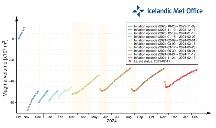 for this) and was able to fit a double exponential decay curve to their data. See https://drive.google.com/file/d/1NPpK6kqxgmGW-MUac05uNp7YsP2j9MXA/view?usp=sharing for this data. Using Maxima, I calculated the cubic meters flow rate per second and came up with this https://drive.google.com/file/d/1bVAWUWQpSk6U8PiSOr-eibItpbnkBA5t/view?usp=sharing so the only question is when does the flow shut down? I see about 10 years for the current Svartsengi eruption series but I welcome more thoughts on this.
Hengill is having a swarm today, 34 quakes since 1.45am.
Seem to get a lot of parallel rifts swarming prior to eruptions so I don’t think we’re too far off.
Read about the middle again as I love the piece:
https://www.volcanocafe.org/the-mountains-of-the-moon/
I believe that cratons are underestimated. This horst-building might happen when a spreading-ridge collides with a craton. Do we have this phenomenon elsewhere? Americas no. MAR? No, of course.
https://agupubs.onlinelibrary.wiley.com/doi/full/10.1029/2007TC002176
From paper: “Nonetheless, Karner et al. concluded that at least 1–2 km additional uplift was needed to explain the extreme elevation of the Rwenzori Mountains. Stern et al. showed for the Transantarctic Mountains that isostatic rebound due to glacial erosion could account for as much as 2 km of peak elevation or rock uplift in rift settings (usage of rock and surface uplift according to England and Molnar.”
It is one of my favourites
It is top! Congrats!
Beautiful picture. And it goes on like this in the piece:
https://i0.wp.com/www.volcanocafe.org/wp-content/uploads/2021/02/word-image-9.jpeg
I might try to get this book:
Alan Moorehead> The White Nile.
“The story of the Nile, from the Mountains of the Moon to the Mediterranean.”
It is old, but very much praised. The history of British colonialism in East Africa well explained by going down the Nile from one source.
That is what VC is doing for me: Getting me interested, then digging deeper in some fields.
In case you get back to the subject one day – somehow the clue for the uplift of the Rwenzori horst might be hidden in the counter-clockwise rotation of the Victorian Plate. If I put a paper plate in a bath-tub and turn the water on it will turn freely having no resistance. Now here on the African continent it is different. So, if s.th. folds up it seems not so much of a miracle to me. (For others: Rwenzori between Lake Albert and Lake Tanganyika, fig.7)
https://www.nature.com/articles/s41467-020-16176-x/figures/1
https://www.nature.com/articles/s41467-020-16176-x/figures/7
There is more in the paper, no problem for a physicist
https://www.nature.com/articles/s41467-020-16176-x
This piece by Hector was certainly great work. I would nonetheless utter some very small piece of criticism.
When I read pieces again I take them from the New Archives. Invariably I chose pieces which start with a good, often colorful picture. Like “Craters of the Moon”.
Now one would think that this Afar is difficult. Not so much though. In the highlands there is some water as well. And of pictures that draw me into a piece and not only me, but potential new readers I offer a selection.
1. Water
Awash National Park
Salt Lake Aftera
2. The setting
with the most prominent feature besides Erta Ale, the hotsprings, going down south through the rift:
3. Animals
The Oryx
Geleda Baboon Juvenile
Oriolus, Ethiopia
And, last, but not least, the all-time survivor and top predator (besides man)
And a wonderful looking girl:
Just a suggestion – and there are certainly many more pictures (these all from wikimedia) –
I go sometimes and browse the archive and I never touch anything with a brown boring picture at the beginning. So, the last four pieces, I will never touch again, I guess, unless I want to know s.th. specific.
With kind regards
Thanks, Denali will consider the suggestion, even though I think it’s a superficial way of judging the content (also given the image ties up to the post in an important manner, it shows the uniquely structured underwater lavas of Manda Gargori volcano).
On a different note, when a comment has more than three images it gets sent to the moderation section, so it’s better to divide the post to include three images in each comment.
Yes Hector, it might be superficial, but I read them often several times, for getting wiser, learning some, for adding some to them, but also for entertainment at night sometimes.
Besides I think we should first show Africa from a pretty side, they might need it. Tourism is a big industry. Thank you for accepting the criticism.
Better picture of Afrera Salt Lake (in Italian Lake Giuletti)
Wow are these from the Etiophian highlands ? they will snatch more rain ortographic rainfall
The waterfall is the Awash River in the mountains east of the rift. The mountains on the other side are higher
Simien or Semien Mountains, Amhara Region, with Ras Dashen (Dejen) being the highest with 4.550 m, Kebnekaijse times two 😂There is eagle and wolf, small though the wolf.
There is also Lake Tana, the source of the Blue Nille, whereas the White Nile comes from Rwenzori or near Rwenzori.
Will my part 1 article be posted today?
You tease!
NO.
😁
Yes, Jesper. In 1-2 hours I think.
A new post is up Jesper in paradise! and we saves the really fun stuff for part 2
https://www.volcanocafe.org/visiting-the-big-island/