(This was Volcanocafe’s 2016 April-fool story. The section at the end explains how the story was designed)
Park to be renamed Yellowstone National Resource
ExxonMobil to use Yellowstone for geothermal energy

Geothermal drilling test at Porcelain Geyser Basin, Yellowstone, during Oct. 2015. The test was carried out by the Park Authority, and showed the viability of using Yellowstone to generate carbon-neutral electricity.
It was announced this morning that ExxonMobil, the largest US oil company, has bought Yellowstone National Park. The price has not been revealed but is believed to be around 3.5 billion dollars. For this, the company gets a 99-year leasehold on the entire park, including all mineral rights. The deal was brokered by T. Boone Pickens, and involves funding from his hedge fund Boone Pickens Capital Management.
The park will be renamed from Yellowstone National Park to Yellowstone National Resource.
A spokesman for Exxon stated:
”ExxonMobil is already highly active in the area of renewable energy and this acquisition shows our commitment to a carbon-neutral future.
”Yellowstone National Resource is uniquely suited to geothermal energy generation. The heat covers a large area and is very close to the surface allowing energy generation at a very low cost per kWh.”
The US government has previously sold leases for 12 national parks to oil and gas companies for exploration and drilling, including Big Cypress National Park (Fl) and Aztec Ruins National Monument (NM). (One lease on an area of the Lewis and Clark National Forest was canceled earlier this year.) It was known that further requests were being considered and that Yellowstone was included on the list. However, this is the first time that an energy company is given full control of a national park.
Sources point out that Exxon, through its subsidiary XTO energy, owns a large part of the nearby Bakken oil field. This is the major shale oil field in the US, situated in North Dakota, about 300 miles from Yellowstone. Exxon has stated that it wants to double production there over the next 5 years. It has recently bought acreage from Henbury, another operator at Bakken, and is expected to put in a bid to buy Hess Corporation.
Whiting Petroleum, the largest producer in the Bakken field, had also expressed interest in Yellowstone but are believed to have been put off by the price set by the US government.
Exxon’s immediate reason for buying Yellowstone was not stated in the announcement. Sources at the BBC state that the electricity generated at Yellowstone will be used in the shale oil production at Bakken, in order to bring the cost of oil production there to below 30 dollar per barrel. This will allow Bakken to remain profitable at the current oil price.
Barrack Obama has put out a statement welcoming the acquisition, which was made possible by executive decision. He said that this would create a northern powerhouse stretching from Idaho to the Dakotas. Donald Trump tweeted his full support, saying that this would make the US great again and would unlock a remote and unproductive park. He proposes to sell all national parks.
Boone Pickens, when questioned on the deal on CNBC, said ”BP Capital Management is a major investor in energy infrastructure. This deal was too good to miss. We are expecting a return in excess of 20% on our investment in Yellowstone National Resource”.

Geothermal drilling rig, Victoria, Australia, of the type to be used in Yellowstone National Resource
Environmental groups have reacted with dismay. A legal challenge is being prepared, which will argue that mineral rights do not cover water and hydrothermal energy. Legal experts think this challenge will not succeed, pointing out that energy resources such as oil and gas are considered minerals under US law.
A test drill was done in October 2015, at the Porcelain Geyser Basin, while the Basin was temporarily closed to the public. The photo at the top was taken at that time. Porcelain Geyser Basin was chosen because it is the hottest of the geyser basins. The test used the type of equipment already operating in Iceland, and was fully successful.
Yellowstone will close to the public from June 2, 2016. Drilling rigs will be put up during June at all the major geysers. They will tap into the hot water reservoirs below the geyser, and use this to generate electricity through a so-called dry steam power plant. Because the water already comes out as steam, it can directly drive a turbine without the need for more expensive flash tanks or heat exchangers. The hot water is replenished through the natural circulation of the water. The geysers will no longer operate, as this would waste the geothermal heat and endanger the rigs. One of the conditions of sale is that Old Faithful will be allowed to operate once a day, with pay-for-view available via a webcam.

Nesjavellir geothermal power station, Iceland
Update
Prof. Robert Houston, from the Department of Geology and Geophysics at the University of Wyoming, has told Reuters that ExxonMobil also plans deeper drilling, to extract heat directly from the massive magma chambers. This is probably safe: there is only a small risk that the reduced pressure in the magma chamber would cause decompression melt of the chamber ceiling. According to Prof Houston’s models, there is no more than a 2% chance this would trigger a major eruption at Yellowstone.
When this was put to the ExxonMobil spokesman, he said that the Department of Commerce had deemed this risk to be acceptable. He also mentioned Exxon’s excellent safety record in oil production and transport, and said that the same rigid safety standards would be used at Yellowstone National Resource.
Update 2
Share prices have responded strongly to the news. Halliburton is up 0.8% on rumours that it will provide and operate the rigs. Exxon Mobil Corporation is down 1%: investors are worried that it may have overpaid. Hess oil is up 3.3%, with investors speculating that there will be a bidding war for the company. Various Alaskan oil companies are down 1-2%. Investors have dismissed the suggestion that The Walt Disney Company may buy Yosemite National Park: its share price is almost unchanged.
Postscript
This April-1 story was designed to appear implausible to the extreme, while in fact almost everything in it has a basis in fact.
Some history: geothermal drilling into the geysers was done in 1927, at Old Faithful. This was done for science: see this report. There has been some scientific drilling more recently, for strain measurements, obviously avoiding the hot springs. No one has proposed using the geysers for geothermal energy: I made that part up. However, it is based on technology which is actually used in Iceland.
A proposal to open up Yellowstone for commercial exploitation (phrased in a oblique manner) was made in 2014 by a politician running for governor. The link was kindly provided in one of the comments above. Comments attributed to various politicians and organisations are in most cases loosely based on actual statements, although taken completely out of context.
ExxonMobil has never proposed for exploration inside the park, to the best of my knowledge. It is involved in work around the park and the company was held responsible for an oil leak into the Yellowstone river in 2011. It has cleaned up the damage (at a high cost) and fixed the pipeline problem, but the mention of their excellent safety record in oil transport is an indirect reference to that accident. There are leases and future plans for areas bordering the park. A Canadian company has asked for permission for exploratory drilling for gold and minerals along the Yellowstone river north of the park. http://thinkprogress.org/climate/2014/07/16/3460799/drilling-yellowstone/ . South of the park (but not too close) there was at one time a plan for large scale gas drilling: see http://wilderness.org/blog/drilling-greater-yellowstone-massive-outcry-erupts-over-well-pads-wildlife-areas
Prof Houston does exist but none of the statements attributed to him have any basis in reality.
Share price movements mentioned in the post were correct as of this morning, but the explanations given here are entirely fictitious.
To drill into a magma chamber to reduce the pressure has been proposed in reality, although without considering whether this might make an eruption more rather than less likely. A risk of 2% of a disaster would be unacceptable in issues of health and safety. However, here it is attributed to the Department of Commerce: the financial and business world takes a different view to what risk level is acceptable. Just ask Lehman Brothers – or their financial oversight.
So I took the different aspects, all based on reality, and extrapolated them. I considered the push for private ownership over the state (the ‘smaller state’); the mining riches of the area, tempting to any company, and the way a company would justify mining the park. That put geothermal (‘green’) energy on the radar.
I am grateful to the various people who helped put the story together. Lughduniense artfully composed the photo at the top. GeoLurking helped getting the politics correct. Any errors are entirely due to me. And if you did see a level of truth in the story, we have something in common. In all of its seemingly implausibility, this is in fact a scarily possible future.
/Albert, 1 April 2016


April 1! Albert this almost had me. Almost
This plan had already been put forward some years ago! Amazing how fast reality catches up on what was deemed fantastic spinning. Back then the plan to drill in Yellowstone was received with contempt and considered entirely flip. Taylor Haynes, a Wyoming GOP candidate, presented a plan some years ago to open up Yellowstone to drilling and mining. Also Presidential Hopeful Ted Cruz is in favor of exploitation of National Parks and Public lands. “Cruz wants to allow drilling on public lands by selling them off first. He intends to amend the ‘Sportsman Act’ of 2014, making it illegal for the federal government to own more than 50 percent of land in any state. It would force the U.S. to turn over management of the excess land to the state itself. If this amendment passed, states could sell the lands instead of burdening taxpayers with maintenance costs. The lands could become open for industrial activities like fracking, drilling, mining and logging”. Add to it that Donald Trump wants to end the dependency on oil from Saudi Arabia, the Middle East and other foreign countries, and this whole scheme of Exxon Valdez claiming Yellowstone may be not so far off.
I think this will cause a major eruption at Yellowstone National Park! Bad idea
In that case, it would be an awesome idea. That would even be better than The Purge. A supereruption would cure all of the world’s problems.
😉
I think this calls for a detailed analysis by Carl and maybe a new series of articles: “The art of fracking a Supervolcano”. That could be the theme of this month 😉
I for one, welcome this latest development and wishes Exxon a lot of success with their Valdez deep fracking rig on Yellowstone Lake. And would like to remind them that as rookie vulcanologist i can be of assistance in setting it off. As the resulting volcanic winter would surely rise my stocks in the oil industry.
Furthermore i look forward too seeing your plans for similar projects located in the dutch Waddenzee and Napels Italy.
So he got away with it?
http://www.salon.com/2014/07/17/gop_candidate_wants_to_open_up_drilling_in_yellowstone_national_park/
It seems so! People had been eying up the mineral riches underneath Yellowstone for ages. Too valuable not to be used.
I can see buying back or reclaiming federal lands that are federal lands for the sake of being federal lands, but I am not for the wholesale exploitation of national parks and monuments. I know ANWR is a political hot button, but it is akin to the federal government owning and setting aside South Carolina (ANWR is 19.29 million acres, SC is 20.5 million acres). That is a lot of land, period.
And here are a few more numbers:
Montana & NM each have 27 million acres owned; AZ has 31 million; WY has 30; OR & ID both have 33 million, NV tops the percentage owned at 81% (or 57 million acres), and AK takes the cake at over 225.8 million acres. Combined, just these eight states account for about 464 million acres of Federal Lands, or 22 South Carolinas, 11 Floridas, or almost 5 Montanas. That is a lot of land for any government to own and manage. All told, the Fed owns 635 million acres or 992,000 square miles (2,569,268 km2).
At some point, it seems less like “conservation” and more like “hoarding.”
The US government keeps federal lands for a variety of reasons, not all related to wildlife or parks. I think it includes all land held in trust for the native american tribes. The department of defense has some, and my understanding is (but this may be wrong) that this includes protection of water supplies and hydro power. About a third of the federal land are for mineral rights (bureau of land management) and the surface may be owned separately. The forest service also tends to be mainly about managing wood supply, not protecting forests (pretty much the same in Europe – trees are a valuable commodity which require long-term management, not something private companies are good at).
In the past some protected land was turned over to the states but this was not very successful, at least in the case I discovered.
The eastern seaboard to the midwest have very little federal land. Texas and Iowa especially have next to nothing. The guideline is that for natural ecosystems, 10% of the area should be protected. Federal land owned for this purpose may come to about that in the USA overall, which is healthy. But it is not very uniformly distributed. Driving through Virginia, I noticed how impoverished and damaged the land appeared, seemingly used to destruction. In contrast, around Mount Rainier the insect life was so much more numerous (roughly measured from splats on the windscreen, the splatometer test). Of course these are only spot tests – many areas I have not seen.
Land management is very important, and decisions about should should be made based on facts and on long-term plans. Not on economics. Nature has no monetary value, but we would die without it. Who can you trust with this responsibility?
No, Albert, I completely agree with the basic premise – and neither do I empathize with the Bundy’s in NV; render unto Caesar, as it were. Yes, our natural resources should be managed, but I do not agree that a Texas-and-a-half is what is required to manage them.
I grew up in rural West Virginia, smack dab in the middle of Appalachia coal country. I come from a coal and lumber family. Yes, the land has been poorly managed previously, and the effects of that poor management shows. But, there has been negative publicity with an empowered public response, and those very same private company and state own lands have been reclaimed without having the Federal Government come in and set it aside. The streams no longer run red with iron and sulfur, slate piles have been removed, abandoned strip mines reclaimed and forests replanted where once it was clear-cut. It may not be a National Park, you will be hard pressed to find a more beautiful and natural country than along the High Germany Valley and south branch of the north fork of the Potomac River in eastern West Virginia (subjectively speaking, of course.)
I guess my overall point is, that yes, once, in the past, the need to sequester large tracts of land were most certainly needed in the interests of conservation but the reasons for that sequester (thankfully) no longer apply. States and corporations have the best reasons to be environmentally conscious – and those reasons are largely economic. If your state is a dumping ground or you are a corporation that is doing the dumping (for instance), citizens will flee, businesses will relocate, and those corporations doing the polluting will be fined/sued into purgatory.
Who do I trust with the responsibility of land management? Us. Here. Not some bureaucrat 3,000 miles away with an agenda that is more politically based than economic or conservation-minded. I would argue all day that we, locals (I live in SC now), know what is best for us and our collective property – both short and long termed – because we live here, on it; we are not idiots that have to be told not to doze over Mt. Rainier to put in a strip mall (not saying you think that, Albert – just using it as an illustration.) People are a lot smarter and responsible for our world now, and certainly a lot more responsive to any perceived slight to it than we once were.
I just think that the BLM and USFS serve superfluous and antiquated roles in our modern world. The states could perform the roles of both cheaper and better, is my guess.
Content redacted!
This comment broke our rule number 1, “Be nice”.
If you have a differing opinion you are welcome to argue it. But going on a personal attack is not okay.
Remember to be nice in the future.
/Admin
And we in England would like all of our houses to be no more than 20 miles away from the nearest fracking rig to help stir our morning cups of tea!
This is a 1 April yoke!
Hi, I have a question. Today I read the earth of fire blog.
http://www.earth-of-fire.com/2016/04/activity-of-popocatepetl-nevado-del-ruiz-tiscani-and-etna.html
Is posible that Tiscani volcano are starting in a caldera forming event?
Sorry for my english and thanks!
I have to start with correcting Bernhard Duyck’s spelling, it is Ticsani and not Tiscani.
It is an explosive reformed caldera volcano and it is about as likeable as Huynaputina, so it is likely to produce something memorable if it erupts.
I agree with Duyck as far as thinking that it is starting to get close to an eruption, but I am not going to say that it will make another caldera-forming eruption.
I will most likely get back to Tiscani soon.
Thank you Carl, always enjoying your explanations!
“During the month of March, 832 VT earthquakes of Magnitude between 0.5 and 4, and a depth between 4 and 10 km, are divided into two groups, the first near the Tiscani, the second 5 km at east of the massif.”
Whenever I seen seismicity divided into multiple ‘clouds’ and/or very large in area underneath a caldera system I remember the precursors to Pinatubo. Somewhat ominous. The reason I wasn’t too perturbed by the seismicity before Holuhraun was that it was pretty much all *outside* the caldera and fairly obviously linear-trending dykes.
Ticsani was actually a volcano I was looking into when Albert was looking for the los 1809 eruptions. Unfortunately, it does not seem a good candidate since there have been studies and dating done on it’s eruptive products, and if it were the right candidate for the 1809 eruption, it would have been fairly obvious.
See my comment on that post here – http://www.volcanocafe.org/love-lava-love-life/
One thing I would caution about what you mentioned Mike, is that separate areas of seismic unrest is a fairly common thing to see for arc-based volcanoes undergoing high seismicity. Not that I doubt the fact that you’re aware to this, but I figure it’s important to note this fact for people who may see it as more ominous than it may entail.
Yes, there were multiple areas of unrest for Pinatubo, but the same can be said for many other volcanoes that never did much of anything. Within the past few years, I can think of many volcanoes simply off the top of my head that have exhibited similar characteristics. Popocatepetl, Nevado Del Ruiz, and Cerro Negro (Colombia), have all exhibited the same type of “clouds” or pockets of seismicity that you described, and this is a sample limited to the volcanoes where we can locate the seismicity specifically. None of these had significant eruptions however, and its likely that many other volcanoes exhibited similar characteristics.
With that said, I don’t think you’re wrong for being somewhat vigilant and concerned. What generally concerns me most is the history of the volcano and the tendencies of the area itself.
While the population isn’t super high nearby, it’s actually a bit more than I would have guessed with 18,160 people living within 30 miles according to the GVP. I like the 30 mile range for disaster status, since that’s somewhat of a good marker for how far a Pyroclastic flow from a good sized VEI-6 can potentially travel. Obviously, most of the people in that range will evacuate, but the ashfall would cause some major issues as most would presume, and it would still be somewhat of a disaster regardless of outcome.
In other news. President canditate hopeful Trump has commented that for now he will neither confirm nor deny rumours of a bit on Mount Rushmore at a local stone carving convention. Stating that he has postponed any final decisions on the matter until november 8 2016.
Best ever April Fools Volcano
http://www.sitka.com/Porky/porky3.htm
Worth a look
http://www.bbc.com/earth/bespoke/story/the-cracks-ripping-earth-apart/index.html
Neatly done, also the moving images while you scroll down!
Pingback: In the news today – Zoopraxiscope
Are you sure Yellowstone Park is not in Sweden? Nice one!
pssssst….. ExxonMobil is only one word.
Correct. But Exxon Mobil Corporation is three
Roger that. Excellent, then!
Exxon are obviously learning from Alcoa and Landsvirkjun in Iceland. April Fool?
I guess when I go to Yellowstone National Park in June it’ll find out in life it’s closed.
Sakurajima has produced a couple of plumes in excess of 3km today:
http://373news.com/_sakucap/
(Not an April Fool’s joke)
And in other news, this morning there was a large earthquake in Alaska, M6, underneath Aniakchak volcano.
Funny, I came here to ask how close a earthquake has to be to a volcano before it’s related, thinking about that the one near Aniakchak, and there’s a post already here. Knew I could count on you 🙂
The earthquake was about 10 km away and 17 km deep and I’m guessing the answer is, it depends on where the magma chamber is in relation to the volcano?
this may help show how close it is
It won’t be in the magma chamber itself, which will probably be shallower. Usually, earthquakes here are along the subduction zone which is deep. This earthquake was in the crust. It could be related to changes in the magma chamber, or even if unrelated, it can create pathways for magma to travel up into the main chamber. Large earthquakes can trigger almost instant eruptions (Darwin writes about this) but probably only when the volcano was already close to erupting. It is not unusual that an eruption is preceded by a significant earthquake a few years before (activity in Krakatoa started that way, with an M6-7. From that point it took thee years to build up to its explosion). But the reverse is not true: most large earthquake do not do this.
Alaska is quite densely packed with volcanoes – almost anywhere an earthquake goes off, there is a volcano nearby. But the fact that this was a fairly shallow quake is an interesting point.
Do you think these shallow quakes aftershocks?
They should be. Aftershocks range up to about 1 mag below the main shock. There might be ones at low M5.
There has been 9 more M3+ since then at varying depths
98km NNE of Chignik Lake, Alaska
2016-04-02 11:13:36 UTC11.5 km
3.4
103km NNE of Chignik Lake, Alaska
2016-04-02 10:25:32 UTC13.7 km
3.6
111km NNE of Chignik Lake, Alaska
2016-04-02 10:01:32 UTC9.5 km
3.7
112km NNE of Chignik Lake, Alaska
2016-04-02 09:45:54 UTC19.0 km
4.1
118km NNE of Chignik Lake, Alaska
2016-04-02 09:06:02 UTC4.7 km
3.8
100km NNE of Chignik Lake, Alaska
2016-04-02 07:49:13 UTC14.1 km
3.6
93km NNE of Chignik Lake, Alaska
2016-04-02 06:19:40 UTC3.1 km
4.3
104km NNE of Chignik Lake, Alaska
2016-04-02 06:00:48 UTC0.1 km
6.2
100km NNE of Chignik Lake, Alaska
2016-04-02 05:50:00 UTC
It is more and more looking like a weird little magmatectonic swarm. Note that the earthquakes generally become bigger over.
It will be interesting to see where this leads, if anything at all happens.
they do look more like magma than tectonic
another one
M3.6 103km NNE of Chignik Lake, Alaska 2016-04-02 12:17:30 UTC
2.6 km
Yeah, the M6.2 at 0.1km would be a bad bet for a tectonic earthquake, but I am still not sure what in earth is going on there.
Would be interesting with a Katmai version there. But it is unlikely.
The 6.2 was at 17km depth. The first aftershock was at 0.1km
How rare is fissure vulcanism in Alaska? If this ends up being volcanic after all, could this become a fissure eruption?
Just curious. 🙂
First of all, you do not get the Icelandic type of fissure eruptions there.
Secondly, you can get a rifting dyke from a pre-existing volcano that then explosively erupts at a distal to the mother volcano. It is though exceedingly rare, I can only come up with the Novarupta eruption that originated from the 10 kilometers distal Katmai Volcano.
the list did not post properly, the 6.2 was deep
let me try to clean it up and maybe an Admin can delete the old list
3.6
103km NNE of Chignik Lake, Alaska
2016-04-02 12:17:30 UTC
2.6 km
3.5
98km NNE of Chignik Lake, Alaska
2016-04-02 11:13:36 UTC
11.5 km
3.4
103km NNE of Chignik Lake, Alaska
2016-04-02 10:25:32 UTC
13.7 km
3.6
111km NNE of Chignik Lake, Alaska
2016-04-02 10:01:32 UTC
9.5 km
3.7
112km NNE of Chignik Lake, Alaska
2016-04-02 09:45:54 UTC
19.0 km
4.1
118km NNE of Chignik Lake, Alaska
2016-04-02 09:06:02 UTC
4.7 km
3.8
100km NNE of Chignik Lake, Alaska
2016-04-02 07:49:13 UTC
14.1 km
3.6
93km NNE of Chignik Lake, Alaska
2016-04-02 06:19:40 UTC
3.1 km
4.3
104km NNE of Chignik Lake, Alaska
2016-04-02 06:00:48 UTC
0.1 km
6.2
100km NNE of Chignik Lake, Alaska
2016-04-02 05:50:00 UTC
17.9 km
I bet that the earthquakes would be more lined into a stack if there where more seismometers around. The earthquakes seems to span all depths from 19km to the surface.
Aniakchak webicorder before the M6 quake: (from AVO)
Here is a seismograph showing the earthquake swarm. It shows the mainshock and the aftershocks. There are many below M3 visible and there is nothing pointing towards and ongoing eruption, nor is there visible HT or LP tremors.
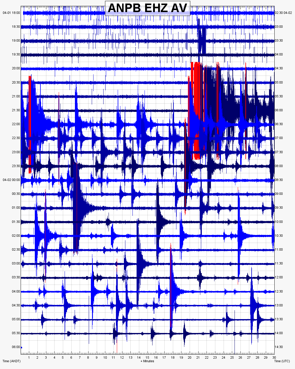
As such, nothing pointing towards any volcanic. But that may change at a later stage.
Latest quake at M3.7 @ 0.1km
Picture of the KISA GPS station
Big crater Aniakchak, from the Observatory:
“Aniakchak Crater is an ice-free, circular caldera about 10 km in diameter and a maximum of 1 km deep which was first described by Smith (1925). The elevation of the caldera rim varies from 1,341 m to 610 m. Surprise Lake, a 3.2-km-long lake in the northeast part of the caldera at an elevation of about 335 m is the source of the Aniakchak River, which flows through a breach in the eastern wall of the caldera. Numerous domes, flows, and cones occupy the interior of the caldera (Neal and others, 1992); the largest cone is Vent Mountain, 2.5 km in diameter and rising 430 m above the floor of the caldera. . Ash flows from the caldera-forming eruption – 3430 +/- 10 yrs B.P. “
Mag 4.4 at 25 miles depth.
What a strange swarm. Anyone know of any faults in the area? Any Beach Balls? I’m somewhat curious if this could be extensional.
I have not found any beach ball yet.
I was thinking the same, that this could be extensional earthquakes, but have no way to prove it.
And here be beachballs…
http://www.emsc-csem.org/Earthquake/earthquake.php?id=498049#map
The earthquakes follow the same subduction stress-regime as the regular fault.
What is rather odd though is that there are no recorded shallow big earthquakes in that region. There are some to the NNE that are shallow, but they are along a transverse local fault.
The only recorded M5.5+ earthquake in the vicinity was an extensional earthquake 80km below Aniakchak.
Historical beachballs

Todays beachball

I think there is only one conclusion here
Rhyolitic Cryptodome
case closed
You really had to do that did you? 🙂
Pingback: The Friday Update #9 (01/04/2016) | VolcanoCafe
The weekly update is now up!
http://www.volcanocafe.org/the-friday-update-9-01042016/
beat me to it 😉
This weeks round up of the activity 😀
http://www.volcanocafe.org/the-friday-update-9-01042016/
I saw interview with Ted Cruz where he said government land holdings including parks were worth 14 trillion, he said it’s a no brainer to sell off and bring down the debt.
released from aksimet’s holding pen
I worked in Chaco Culture NHP and Aztec is the sister site. Though the area has some great natural gas and oil resources, Aztec is such a small site I wouldn’t imagine anyone choosing to drill there. Chaco on the other hand…. Glad this was an April 1st joke, had me worried for a bit.