
Columbia flood basalt. Copyright Marli Miller, https://geologypics.com, educational, non-commercial usage
Greetings. This article has a long history of not being written. It originated a few years ago when the 2018 lower Puna eruption was on going. Before I start, let me vent. IN MY OPINION, there is no such thing as a “Supervolcano”. That term was popularised by the BBC for their disaster movie of the same name, released in 2005. Oddly, Wikipedia nails it. “It is based on the speculated and potential eruption of the volcanic Yellowstone Caldera” (bold added). As far as entertainment value, it’s passable (sort of)… as volcano disaster movies go, it beats ‘Dante’s Peak’ where a pickup truck crashing into a cave can save you from a pyroclastic flow! (Not to mention Cris Pratt and the dinosaurs outpacing one in a Jurassic World movie) -> not his fault, he just does the acting.
The term ‘supervolcano’ doesn’t even have a definition that can be tested. Amazingly, it was first used for the Three Sisters! At one time in the early 1900’s it was proposed that the Three Sisters were one volcano. This was proven wrong in the mid-1900’s, and in a discussion of this proof, the term ‘super’volcano was first used – to describe something that did not exist! Like ‘Big Bang’, it was a term coined to sound silly.
Later (much later) the word ‘supereruption’ became in use for VEI-8 eruptions, and after that a ‘supervolcano’ was one capable of a ‘supereruption’. That is not helpful either. To know it is capable it should have done one. But a supereruption obliterates the original volcano and leaves a very large hole in the ground – a caldera. Are the myriad large calderas of Hokkaido supervolcanoes? How about the collection of large calderas on Rabul? The three calderas of the Los Frailes volcanic complex in southern Spain? See https://www.usgs.gov/news/a-personal-commentary-why-i-dislike-term-supervolcano-and-what-we-should-be-saying-instead who argue that ‘supereruption’ is definable, but ‘supervolcano’ is not. That comes from YVO, so they should know!
A more accurate term is “Large Caldera Eruption”. With that term, all an eruption has to do is be in the upper half of caldera forming eruptions. A good reference would be the table of data compiled by Dr Peter L Ward that documents pretty near every major eruption for the past few million years. Find the size of the listed calderas, and the upper half of the size would be the large calderas. Spoiler alert, there are a lot more than you would expect. A clue for the doom mongers…. Yellowstone is not currently erupting, nor does it seem to be in a run up phase to do so. Tondano, a large caldera system in Indonesia, has frequent eruptions yet the doom mongers never seem to notice.
To quote Carl le Strange from a previous incarnation of VolcanoCafe:
“Some volcanoes just can’t catch a break. Imagine for a little while that you are a bona-fidé supervolcano. You are the largest of your type on the planet, you are highly active, and by gosh you have shown what you are capable of. In a perfect world your 20 by 30 km caldera explosion should have put the world into awe, and the 1,000 cubic kilometer of DRE you ejected in the form of pumacious tuff covers an entire sub-continent. Yep, you really did reach the small highly exclusive club of VEI-8 volcanoes. You smirk at your little sibling Monte Somma’s antics with Vesuvius. Your Vesuvius-style event left a 3.5 by 5 km God honest caldera on its own. To top it off you have a huge underground reservoir of liquid acid that would seriously alter the planets weather if you felt like discharging it. You are also perfectly located to have a maximum kill ratio. So, you wake up and stretch your arms and start a double eruption from two different sub-volcanoes just to celebrate the new day. You have your largest eruption in recorded history. Then you look around to see the fearful faces of the residents as they offer up motorcycles in your name, you expect volcanologists doing somersaults as they play lip banjo, and literally thousands of blog pages glorifying your power and shear awesomeness. What do you find? Yawning people and a cockerel trying to wake up a pig sty. You find that for being an erupting supervolcano you are a massive PR failure. One single small earthquake at Yellowstone outperforms you in publicity.” (September 27, 2012).
And yes, as large calderas go, Tondano is MASSIVE. But that is not why I’m writing this.

Source: USGS. The extent of the Columbia River Basalt group. https://www.usgs.gov/observatories/cvo/columbia-river-basalt-group-stretches-oregon-idaho
I have long had an interest in the Columbia flood basalts. This is a young flood basalt which covers Washington, Oregon and bits of Idaho and Nevada – making it a ‘small’ flood basalt. It erupted 16 million years ago, over a period of about 1 million years. The oldest part is at Steens mountain, at the southern end of the Columbia flood basalt. This is also near the start of the hot spot trail that left seven volcanic fields with large calderas, starting at McDermitt (16.5 million years ago) and stretching all over Idaho before ending (?) at Yellowstone (2 million years ago). Where did the hot spot come from? The trail prior to 16 million years has not just gone cold, it isn’t there. And how did a flood basalt morph into an explosive large caldera trail?

My original thinking was that the magma upwelling behind the detaching Farallon Plate after it’s full subduction had caused it. There is a high probability that that was wrong. My current thinking, based on several videos by Nick Zenter (the chalk board guy at Central Washington University), is that the Yellowstone hot spot used to be the nexus of an island, not dissimilar to Iceland, that subducted/accreted and eventually tracked to it’s current location. Whether it was part of an island chain or a ribbon continent depends on what paper you read. Accreted terrane is accreted terrane. Through petrological analysis of the accreted complexes it is evident that several sequences have been plastered onto the North American craton. Zircon analysis show that some sources originated from the west as well as the east.
While watching some of Zentner’s videos, I learned of an isotropic characteristic that tells whether a magma erupted through an accretionary complex, or through a craton. Essentially, the Strontium 0.706 line denotes the boundary of the North American Craton. This is the line where the 87Sr/86Sr ratio changes from below to above this value: the higher values are found where there is continental crust. (It is the green line in the plot, derived from multiple sources, principally USGS data.) It is in effect where North America ends and the accreted terranes begin. Notice that the Large Caldera events did not begin until the hotspot had passed under the North American craton, with all of it’s continental sticky silica. Steens Mountain, linked to the Columbia Flood basalts, is on the other side.

(There is disagreement whether this line is the edge of the North American craton or of continental crust in general. But that is not the main point. It shows where there is mainly oceanic crust or mainly continental crust regardless of their precise origin.)
Something interesting happens when you look at the 4.5 km geothermal potential;
 Take a look near Redding California. South of there is the Mendicino National forest. Coincidentally, near there is the Mendicino triple junction, the northern end of the San Andreas strike-slip fault. What else is at or near Mendicino? (From a quick Google search) “The Geysers is the world’s largest geothermal field, containing a complex of 18 geothermal power plants, drawing steam from more than 350 wells.” Strangely enough, that bar of elevated geothermal potential seems to point at the well known track of the Yellowstone hot spot. From my previous plotting frenzy during the lower Puna eruption, I estimated the Yellowstone hotspot as being located just off the coast of California/Oregon area about 30 million years ago. This fits with other work I have seen by actual geologists. I attempted to recreate that plot for this article, but failed spectacularly. I didn’t have time to back out the relative plate motions since then. (Either way, my calculations were off by an easy 1% in distance alone and my bearing calculations were horrendous.)
After watching a series of Nick Zentner’s videos, I have come to the conclusion that the Yellowstone hot spot, at one time was the forming mechanism of an island not unlike Iceland. Zentner relates three possible ideas of what collided with the North American craton. They range from an island chain, to a super terrane, somewhat continental in nature. Continents can be quite diminutive. New Zealand is a good example. “Zealandia” is a proposed submerged continent with only New Zealand itself still above water. Palawan Island in the Philippines is a crustal shard that detached from Asia quite some time ago. Mindoro Island being the eastern end that is currently smashing into the Philippines near the mobile belt. (See my “Sleeper Fish” article on VC from years ago). Other things that come up in Zentner’s videos is that multiple subduction zones and terranes have accumulated, building Washington State and Oregon much like an encrustation of bugs on a windshield… complete with carbonate platforms from ex reef system when the islands were bopping around out in the south pacific. The “Baja BC” idea stems from palaeomagnetic evidence that shows many of Washington State and Oregon’s plutons and rock structures originated as much as 3000 miles south of their current latitude. (Hence the “Baja” part of the term)
My contention is that SOMETHING… sort of a cross between Iceland and the Philippines, impacted the North American craton. I say Philippines because it currently has both eastward and westward subduction occurring on either side and serves as a good example of you can have both forms of subduction on an island chain. Siletzia, or the previous terranes, (Insular etc.) existed as a hotspot driven island/continent at the focus of at least one spreading center with other crustal boundaries attached. The long departed Kula plate was likely the northern plate of that spreading center. What other hot spot sits in a spreading center? Iceland.

My apologies for harping on the Philippine example. I have been a bit obsessed by the battle of Samar Island, the location of probably the stupidest tactical blunder I have ever heard of. {Not really Admiral Kurita’s fault, he was inundated by the details of conflicting information from the fog of war. He made his decisions based on mission guidelines handed down to him by bureaucrats and what he had at hand for intelligence… plus what he could see for himself}
It turns out that similar ideas to mine had already been proposed. Siletzia accreted on western America around 50 million years ago. It still forms the west side, extending underneath part of the Cascades. After accreting, the terrane rotated by 75 degrees. It has made things rather complicated. Siletzia is a flood basalt, older than the Columbia basalt and also much larger. It is dated to 50-55 million years ago. The suggestion has been made that it was formed at the Kula-Fallaron spreading ridge and that the Yellowstone hot spot was at the right place at the right time. This was the original Iceland (or at least a subtropical version), which 8 million years later was plastered onto America. See Wells et al 2014.

From Wells et al., 2014: accretion of Siletiza and Yakutat (Y). YHS indicates the possible locations of the Yellowstone hot spot
The Columbia flood basalt still needs an explanation. One suggestion (Wells) is that the hot spot was reactivated by slab rollback, and melted through the Siletzia basalt. But the main point made here is that shortly after, the Yellowstone hot spot entered the area of the old continental plate and that this started the sequence of large caldera eruptions.
Getting away from that, in Idaho, north of the Yellowstone HS track, is a mining district that produces ample silver and gold from the mineralization of emplaced plutons. These are likely the result of the YHP pushing magma up that never actually erupted. The mineralization following a process similar to the Los Frailes caldera systems of southern Spain (not quite as stupendous as Yellowstone, but large calderas unto themselves.) A USGS article on the topic.
How all of this relates to the formation of the Rocky Mountains and the formation of the Basin and Range province I’ll leave up to Mr Zentner’s videos. My advice is to load up on coffee and clear your schedule for an afternoon or so. They are fascinating.
One final item. The Philippines is claimed by Wikipedia to encompass around 120,000 sq miles of land. Washington State – 66,544 sq miles, Oregon – 95,997 sq miles. So whatever actually collided (or was run over by North America) was just a bit larger than the Philippines, possibly even twice that size since much of it is splattered across British Columbia and up into Alaska. Something else to consider. Some theropods were enormous. The first ACTUAL dinosaur bone found in Washington state was on an island near Vancouver. In my book, that goes a long way in calling the colliding land mass a small continent… unless dinosaurs similar to T-Rex were adept open ocean swimmers.
If you wish to study this further, I recommend Nick Zentner’s collection of references on Baja BC.
For his videos: Eocene A to Z is quite informative.
By the way, when it comes to the idea that Yellowstone is over due… in my opinion that is “bovine excrement.” Look at the time periods of the known Yellowstone originated large caldera events, you get a “due” date period of about 3.54 to 2.97 million years at the 90% confidence interval. At best you will get yet ANOTHER caldera infill event as the caldera floor gets paved over. If you don’t have a good lid on the pot, you are not going to get over pressurization. Maar style eruptions? Yes, that is possible. West Thumb is one such feature in Yellowstone lake. And as you know, volcanoes tend to erupt in a similar manner as they have previously done. Years ago, I tracked one collection of seismic events NE through Yellowstone lake up towards “Fishing Bridge.” I believe underwater surveys found pillow lavas down there some time before that. For those that don’t know, the “moon-bat” community was frantic that we were all going to die. I know because I was reading many of their discussion forums.
I have been advised to write a closing statement. This is difficult to do. I have the unfortunate characteristic of not being able to shut up once I have made my point. The best that I can do is to tell you that there is a huge amount of stuff that is far more entertaining than what you find on the TV. You just have to dig around on the internet to find the relevant papers. Some of what I did not address is the La Garita caldera in Colorado. My initial feel is that it was formed due to decompression melt from the crinkling of the North American craton as the various terranes accreted. Additionally, how did the Meteor hotspot get on the other side of the Atlantic spreading center? It has been implicated at reactivating the Reelfoot Rift, a precambrian weakness that was in competition at becoming the Atlantic Basin when it opened up about 200 myr ago. Back during the Atlantic Basin’s early life is when the Canary Islands began forming. They sit on top of phyllite. Metamorphed basin sediment. (The white part of the “floaters” from La Restinga pumice).
In short, if you have a question about geophysical processes. The data is out there, all you have to do is go find it. If we can’t answer it here, someone has probably already written a paper on the topic.
Many thanks to Albert for kicking me in the arse to get up and actually write this article that I have had rolling around in the back of my head for years. Additionally, he helped smooth out some of my disjointed thoughts on the matter.
Geolurking, July 2023


Thanks for your excellent effort and the additional links to be perused.
So there was a tropical Iceland outside US west coast 55 million years ago? during PETM
it is a fantastic story about the complexity of the US west coast. It gives the Yellowstone hotspot a history involving two flood basalts and a series of supereruptions. I never knew Iceland could be so dangerous!
Perhaps it is a good thing Hawaii and Iceland are in the middle of the ocean with thin crust as opposed to sliding under thick continental crust. What would happen with Hawaii if it were marching through a Craton? Its large and deep enough I imagine it would just march through the applicable craton and if it took too long to break through we would get a flood basalt when it finally did.
It already has the volume to almost count as it is, Hawaii has erupted twice what the CRB did and in 1/3 the time. It is just that the scale of actual eruptions on Hawaii is relatively normal, it isnt doing 1000 km3 lava floods, so it doesnt get LIP status. Which is a little bit of an oversight in my opinion…
Im enjoying the eruption live stream in Iceland, loves it, but the cone haves to be given a name, given Icelands high fantasy tolkien feel lets call it ”Sammath Naur”a fitting name live stream here https://m.youtube.com/watch?v=yJfiMhqLgTY&pp=ygUMbGl0bGkgaHJ1dHVy
Only thing left for me is To live in Iceland
I’ve read somewhere that the cone has been named after the late son of the owner of the land the volcano opened on to. I’ve let the name slip. Someone herein must know it.
Kobbi 🙂
Well.
This belongs to the chapter “has to be read a few times”.
Let me start with this: “The “Baja BC” idea stems from palaeomagnetic evidence that shows many of Washington State and Oregon’s plutons and rock structures originated as much as 3000 miles south of their current latitude. (Hence the “Baja” part of the term)”
Sure. On the bottom of the ocean like the Colorado Plateau, the latter between 1000 and 2000 my, just about, having survived many mantle plumes.
Timing is possibly what you might have neglected, but as I said I have to read this again.
About the movement of most of the terranes over there the Wrangellia series of Albert is enlightening. California is supposed to travel there as well. They seem to move north. The continent altogether moves west, maybe slightly northwest by rotating, counter-clock-wise, I believe, but have to look it up.
Just a start.
Q: Is this “I teach geology/Tw/yt/Zentner” accepted by the rest of the scientific community, say the likes of Ron Blakey?
Zentner is quite forthcoming about the Baja BC evidence being overlooked/ignored by others in the community.
Basically, Lurking, this doesn’t have a whole lot to do with Iceland, let alone the Philippines.
This Columbia River Basalt most likely has to do with the Laramide Orogeny (shallow angle, flat slab subduction) which led to the Basin and Range Province (extension) and the subduction of the spreading ridge west of the Farallon Plate known today as the San Andreas Fault, ending at the Mendocino Triple Junction. These enormous changes would, naturally, cause massive volcanism.
Accreted terranes are west of the former spreading ridge aka San Andreas Fault and tend to travel north as usual.
So this Flood Basalt (CRBG) is mostly the consequence of the subduction of a spreading ridge and can happen again, long after us, further south.
Most flood basalts seem to have happened in close proximity to spreading ridges (Deccan Traps, Paranà-Edenteka, NAIP, possibly in a smaller form Fagra), and a mantle plume is not needed as an explanation and, if not proven, only a possibility. Besides, it is difficult to use the mantle plume theory for both, the CRBG and the Snake River Plain, it is possible, but with some twisted musings.
So, in one aspect, this is like Iceland: Spreading ridge, in its grave though. In another aspect it is also comparable to the Philippines: Utterly complicated.
Anyway, the timing of the formation of the Basin and Range Province and the subduction of the predecessor of the SAF fits very well. A comparison I would dare any time is to the situation up north with huge earthquakes and enormous volcanism in Alaska and the Aleutian Islands, an island arc, that also existed once west of the debated coast, when the Sevier Orogeny was built up.
Denaliwatch:
What do you think of the North American Indian legends ( I believe native Americans in Idaho) which describe sudden fissure eruptions. One spoke of yellow hot lava suddenly erupting which is so fluid that it was hard to outrun.
I don’t believe that they just fabricated these stories. I believe that there is actual geological events behind the story.
See https://www.nps.gov/subjects/volcanoes/traditional-knowledge-of-prehistoric-eruptions.htm on this
Craters of the moon is a serious volcano. It has done eruptions that are larger than most of the Icelandic eruptions at quite regular intervals in the Holocene, its next cycle is due some point in the next few hundred years although there is rounding error of course.
There are 30+ km long a’a sheet flows coming from the fissure swarm. Pahoehoe flows even further, showing eruptions are both long lived and begin with a flood from hell, perhaps the best example today of a Jesperian eruption 🙂 . To flow so far on flat ground and completely unconfined these eruptions were probably comparable to Laki, at least the opening sequence is.
Thats right the bigger it is the more rad it is for me 🙂
The last eruption buried an area of about 330 km2, mostly in the huge Blue Dragon pahoehoe flow. This was erupted pretty fast though, all of the vents have spatter cones and many perched ponds, it was probably the very flat terrain that made it into an inflated pahoehoe flow.
The Wapi lava field is equally big and was formed in the same rifting event, even though it is 70 km away from the Blue Dragon vent. Blue Dragon erupted probably for several years somewhere between 350 BCE and 130 BCE, while Wapi formed in about 300 BCE. So they are basically the same, about 650 km2 of land buried by lava within a couple decades at most.
And the early Holocene Grassy Cone eruption was even more impressive. A’a flows went up to 30 km away, and one flow is a pahoehoe sheet flow that begins turning to a’a only at distances of over 10 km from the vents and goes as far as 18 km before stopping. One later pahoehoe flow went as far as 55 km away in two different directions. And that is just what is exposed today, there have been many eruptions since and only the tall Grassy and Sunset cones survive on the surface as vents of this eruption. Given how far apart some flow sare the initial fissure was probably almost the entire length of the field, perhaps 20 km. So this really was probably almost as big as Laki, and that is despite no caldera existing at this location, its magma storage is deep, so possibly very large and with eruptions beginning very suddenly with powerful quakes and rapid rise.
A caldera probably will form eventually though, because the lava is actually not basalt, the pahoehoe is but most of the initial a’a lava is very hot trachyandesite, still very fluid but it is far from mafic. It is like Hekla and Laki combined into one 🙂
You’d like to know what I think of those legends. Take this and make your own picture:
“Serpent Legend (Ella Clark, Indian Legends of the Northern Rockies, p. 193-194):
Long, long ago, a huge serpent, miles and miles in length, lay where the channel of the Snake River is now. Though the serpent was never known to harm anyone, people were terrified by it. One spring, after it had lain asleep all winter, it left its bed and went to a large mountain in what is now the Craters of the Moon. There it coiled its immense body around the mountain and sunned itself. After several days, thunder and lightning passed over the mountain and aroused the wrath of the serpent. A second time flashes of lightning played on the mountain, and this time the lightning struck nearby. Angered, the serpent began to tighten its coils around the mountain. Soon the pressure caused the rocks to begin to crumble. Still the serpent tightened its coils. The pressure became so great that the stones began to melt. Fire came from the cracks. Soon liquid rock flowed down the sides of the mountain. The huge serpent, slow in its movements, could not get away from the fire. So it was killed by the heat, and its body was roasted in the hot rock. At last the fire burned itself out;the rocks cooled off;the liquid rock became solid again. Today if one visits the spot, he will see ashes and charred bones where the mountain used to be. If he will look closely at the solidified rock, he will see the ribs and bones of the huge serpent, charred and lifeless.”
https://www.nps.gov/crmo/learn/historyculture/native-americans.htm
What I think?: I think it is an extremely pretty story, picturesque. You can easily read it to your children if they don’t want to go to bed.
Not far from the Craters of the Moon, 40 miles as the crow flies, in Ketchum, Idaho, Ernest Hemingway got up one morning in 1961, took a gun and shot himself fatally. Nobody knew why. Now we know. The late snake told him to do it. Indian Legend, modern version.
Another modern version, more artistic though: “Shining”.
Oh man, the laughter of Lack Nicholson.
Zentner is teacher trying to solve a puzzle. It is the interaction during the lectures (26 of them) with a number of recognised geolisists from all over the world that provide the pieces. Imho the Baja BC is the best A-Z series he made up to now. Really well done (mind you, it is really hard science and methods that are discussed for the public)
There is no puzzle. There is only a divided scientific community because some are attached to the plume theory without evidence. It is Plate Tectonics at its complicated.
Recently I met a retired geologist (specialized in sediments) who didn’t even seem to understand simple Plate Tectonics.
most complicated
Thank you GeoLurking for the article. I have been busy today and just now came back to watch the Iceland volcano, and at 22:11 pm local Time Monday 17-July-2023, there is increased gas pressure both at the cone but also in the fissures to the north. The spot at the upper left hand corner almost off the edge is also fumeroling.
Question for GeoLurking:
Please see https://pubs.geoscienceworld.org/gsa/gsabulletin/article/133/5-6/1128/592051/Raising-the-Resurrection-plate-from-an-unfolded particular figure 2.
I have read some scientific publications on the mantle tomography supposedly showing the subduction of the Farallon plate underneath the mid to northern Rocky Mountain area.
Do you think the subducted slab information in figure 3 is accurate? Do you think the Resurrection Plate hypotheses helps explain what we see?
I am here in WA state and fascinated by its volcano history
In regard to Pasco WA, the 16,000 feet of basalt deposited (over 3 miles thick) is simply astonishing, but also the pillow lavas show that central and eastern WA was under water at the time, a lot of the time. Maybe huge freshwater lakes?
Thank you for your article.
I will add one more thing, the Craters of the Moon in Idaho point to the fact that eruptions are still possible today Last year I tracked NASA flying several planes over this region, taking volcanic measurements. They used 747’s mostly, but also some U2’s were used. One key flight that went over Mt Shasta, then Craters of the Moon, then suddenly turning south to go over New Mexico and then over the San Franciso volcanic field in Arizona told me what they were watching.
Interesting. I’ve seen that dangling part referred to as Juan de Fuca only, and the slab wall under the east coast US is missing from their topographic image. Possibly deeper than they provided.
The main point is that there is a lot of info available if the curious go looking for it.
*tomographic
There is an article by Ari Páll Karlssonin in Ruv News about the moss fires. You can read it all here:
https://www.ruv.is/frettir/innlent/2023-07-17-mesti-mosabruni-fra-thvi-skraningar-hofust-388193
Highlights:
This is the largest moss fire since organized records began in 2006.
Approximately 250 hectares have been burned.
It is imperative to extinguish the burning moss because a moss fire is worse than a grass fire.
With a grass fire, just the tops burn, the roots are spared. When the moss burns, the entire plant is lost, exposing the thin soil which is then in danger of blowing away, exposing bare rock.
The loss of the moss has consequent negative effects on birds/small animals/insects etc. that live on and in it.
Burning moss also releases noxious and greenhouse gasses.
The East Snake River Plain makes it look like the hotspot has leveled whole mountain ranges in its path.
(Perhaps it carried the Ark of the Covenant before it?)
Not looks like. Has levelled. The eastern Snake River Plain is directly due to the hotspot’s passage.
Yes, that’s really fascinating. How did that happen? Was it the caldera collapses combined with melting underground? Was it extension? Or subsidence due to the intrusion of dense mafic cumulates?
22:54:20 Big collapse on east wall.
Gusher started at 23:46:00 pm and still continuing 1 hour later 00:46:00 am as far a lava flowing from the cone in the field of view of this camera https://www.youtube.com/watch?v=yJfiMhqLgTY
Isak is live
This is too good, thanks for your efforts! Really stimulating read and love the additional resources to peruse.
These are among my favorite types of articles on the site, ‘geophysical / paleotectonic forensics.’
I think, when we finally land a spacecraft at Io to study the volcanoes there, someone is going to make the trip there just to be able to stand in front of the camera…
I expect that you saw that individual walk by just a short time ago. Precisely the same look as yesterday evening. From the same side. Likely the same person.
On the official map released today, that location is off limits. Behaviors as expected.
Watching fumeroles on both the cone and around it https://photos.google.com/photo/AF1QipOaYbW4ekGufasmICvm2N7stTKGICFrZ4DEHkVD as the activity seems to have slightly increased the past 8 hours or so
I can’t tell. RÚV seems to be applying a blur filter to the stream for the past four hours for some reason. :/
They could also stand to put a little parasol above the camera (but below the solar panels) to shade it from sun-glare. 🙂
I’m afraid a parasol wouldn’t stand a chance in the Icelandic winds. It would have to be something really sturdy.
Before you file your next complaint, I suggest you go watch the recording from Isak’s live stream. It’s posted just a few comments above. Near the end he films the hill where the RÚV cam is situated. Does it look like an easy hike to you? Can you imagine dragging the equipment up there and then maintaining it? Oh, and you can clearly see RÚV’s blur filter in action – it’s smoke from the moss fires that are still burning.
Everyone who is monitoring the eruption (TV companies, IMO, volcanologists, other scientists) are doing a great job. Plus those on the ground keeping visitors safe. Admittedly, this is a mild effusive eruption in a relatively accessible location, but it is not many countries who can provide such detailed live coverage.
RE:”Does it look like an easy hike to you? ” Well SOMEONE’s been up there in the middle of ‘the night’ twice in the past 48 hours. I saw the person walk past the view of the cam.
Just because someone is doing it doesn’t mean it’s easy. If you didn’t understand my point, I’ll just spell it out:
Show some appreciation for the people running the webcam and for the hard work that they are doing. Quit your whining every time it’s not doing what you want it to. Understand that it’s difficult to run a webcam in this remote location under these conditions and that there will be more glitches, whether you like it or not.
……and my point is that if one can assume that the figure seen, at that hour, was a member of the team maintaining the equipment, who is lawfully permitted and expected to do so when necessary that’s understandable. One may also assume that the figure was a ‘visitor’ whose presence in that location, regardless of time of day, was purely for self-gratification and blatant violation of the terms of the re-opening of the site with designations of restricted areas one of which that individual had entered. Not un like the ’21’s, there’s a photo being circulated of someone on the slope of one of this event’s young spatter cones. There’s always some in every crowd and, given the right circumstances for justification, the powers that be will pull the plug on everything to the detriment of the rest of us.
“””An announcement from the Police in Suðurnes says that the hike takes about five to seven hours and is not suitable for everyone. It also says that rescue team personnel came to the aid of several people yesterday and last night, but no serious cases occurred .People are asked to behave in accordance with the instructions of the police and rescue teams and not to enter marked danger and prohibited areas. It is expected that the gas pollution will reach the south today and that it will be felt on Suðurstrandaveg and on the hiking trails to the gas stations.
“It is important to note that the eruption area is a dangerous area where conditions can change suddenly. Police are warning people to stay close to the eruptions due to gas pollution. Danger increases when the wind dies down. Then life-threatening gases can collect in depressions and can prove fatal. “New fissures can open with little notice and glowing lava can fall from the edge of the lava and there is a rapid and sudden advance where new lava tongues break out which can be difficult to avoid while running,” the announcement says.””” VISIR also reported yesterday that private vehicles were being parked in areas reserved for emergency service vehicles, personnel, and equipment thus potentially hampering their efforts should they be needed.
The article bridges well the topic of Wrangell Mountains https://www.volcanocafe.org/building-the-wrangell-mountains/ with Hector’s recent Mexico story. North America like Europe is an accumulation of many smaller microcontinents, and Siletzia reminds to the geo-history of Yukatat.
I was thinking about the link to recent volcanism in Washington: Mount St. Helens. The rotation of the microcontinent may induce rifting at Yellowstone and a unusual subduction process around St. Helens.
Is this Webcam located at Meradalir? https://www.youtube.com/watch?v=LykVVU3C6D0
No, when it pans to the left, Meradalir is the basin in the distance. It used to look that way frequently; but, now that the lava front is out of view, it does so rarely.
The smoke is really increasing around the exit side of the cone towards the right side, the last 2 hours. Can anyone explain what the material on top of the lava lake ot the far right is? It looks a lot like pumice floating on a lava lake. See https://www.youtube.com/watch?v=yJfiMhqLgTY I will assume that all the smoke emissions currently indicate lava that is really rich in sulfur and sulfur compounds.
It’s difficult to differ moss fire smoke from volcanic gas/steam/dust. The view from Reykjavik shows some vog now. https://www.youtube.com/watch?v=iAD3F0EWvnQ
Probably the capital will have to get used to this air pollution as a regular problem.
Wind currently comes from west-northwest, that is likely not VOG from the eruption. mThe smoke shall be drifting to south-southeast at the moment. This is also obvious at this stream:
“New Zealand is a good example. “Zealandia” is a proposed submerged continent with only New Zealand itself still above water.”
Not strictly true; the continent of Zealandia (which is pretty well accepted now) includes several other islands, notably Norfolk Island, and New Caledonia as well as New Zealand.
Which is why I also mentioned Palawan
Regarding the article, just looking at the timing between the different locations and the slow-down of speed, one could guess that the current caldera is more or less ready and that it is building up for a new bang in about 500 thousand years. Just a statistical observation. Not what the press would like to hear to get their clicks, but…
Strongly agree.
An Aleutian island tossed up 30kft plume the other day… no one seems to have noticed.
https://www.youtube.com/watch?v=eoOjltjIB1g
https://www.youtube.com/watch?v=h3_YtDJD2FM
https://www.youtube.com/watch?v=3eV0qQ0Cm_A
https://www.youtube.com/watch?v=aWqSY1QpS20
Some nice videos of 2021 it had low viscoisty for soure
Many thanks for that, GeoLurking. I’ve seen all sorts written about the west coast structures, but yours is the only one that makes 100% sense. Nice investigation. Thank you!
Looking at this stream (jump back and forth in time) one can now see that lava is flowing to the (north-)east towards the watch-point, just as I predicted based on the Topo-maps:
https://www.youtube.com/watch?v=x7a9O2fBEnU
Gravity has an heavy impact… 😉
It can also be observed at this stream, but not as obvious as this only shows one tip of the snake’s tongue and not the base of the flow as the other is showing:
RUV today saying the volume of lava on the 18/7 is a little under 9 million m3 and effusion rate of 13 m3/s. So a bit over 1 million m3 a day.
The flow front also moves by a couple hundred meters daily although very variable depending on how confined it is. But expect it to overflow out of Meradalur in the next few days, apparently on the 22 is most likely.
The deepest part of the flow is 20 meters, the average is about 10. So it goes to show how different a’a and pahoehoe behave, if the eruption stopped right now and was never observed a conclusion might be drawn that the lava was relatively sticky which is not the case at all, just that the average effusion rate is high enough to induce the transition to a’a even on flat ground. As the flow advances the channel will become more efficient and overflows will leace a smooth pahoehoe texture. It could be hard to form a proper tube with such a high effusion rate though, at least it will take a lot longer than it would in a pahoehoe flow.
Nice chunk of overhanging rim to the left of the channel broke off…15:20:30.
Nice chunk of the overhang to the left of the channel broke off…15:20:30.
https://twitter.com/manu_oberhuber/status/1681294335793328128
Lava discharge data from the ongoing volcanic eruption at Litli Hrútur published today by
@Haskoli_Islands
show an estimated rate of 12.7 cubic metres volume released per second which is similar to levels reached during the 2021 eruption https://jardvis.hi.is/is/eldgos-vid-litla-hrut-nidurstodur-maelinga-17-juli #iceland #volcano
The second link has a couple of good maps of the July 17 lava extent relative to the 2021 and 2022 eruptions.
I still like this explanation best, it isn’t incompatible with reactivation though:
http://www.mantleplumes.org/CRBEllipse.html
The eye has a tendency to pick out patterns where none may exist..
Is our current cone beginning to start its geyser behavior? Lots of lava flowing from the vent around 16:50 pm or so, then begins to quiet down around 16:55 and looks almost shut down (but it is not) at 17:02 as you cannot see any of the lava outflow in the channel at this moment. https://www.youtube.com/watch?v=yJfiMhqLgTY I remember when the last active cone in the Geldingadalir eruption started to develop geyser action, it was subtle at first but then became more and more obvious until we ended up with those 300 meter+ fountains.
Interesting, it does look like some possible gushing/geysering. I had been wondering if it would start doing so, since the eruption didn’t seem to be declining. 2nd attempt at making a shield volcano?
I moved the replay back on the gusher event, it started around 15:21 pm but definitely was in action at 15:25 pm and continued for 100 minutes and shut down at 17:01 pm
Agree with your observations and was going to post about the most recent one. The other thing I noticed was that there appeared to be a vent directly where the lava fall starts which is only visible when the output is at its maximum. I initially thought the vent was new and had unblocked something but the patterns are too similar to what we have seen before. Am finding it hard to stop watching to be honest!
I saw the same vent, active only when the flow is high, splattering at times. It is one of the original vents I believe. And yes, you are right, volcano watching is addictive, maybe too much so!
At 15:20:30, a large chunk of the near wall collapsed. Could this have caused a plug or backup or something that resulted in the gusher?
I would expect a partial wall collapse would affect the outflow of lava for say 10 – 15 mins or so at the maximum, but the outflow was 100 minutes. I am keeping my eye on these outflows to see if a pattern develops, I suspect the geysering period will be twice as long or even perhaps more than that at Geldingadalir which was around 30-40 mins or so (relying on my faulty memory here)
Thanks, makes sense.
The really cool thing is that it’s visible in the tremor plot:
I think that confirms it.
Strange, neither the image nor the url shows on my mobile. It’s the odf tremor plot. hraun.vedur.is/ja/oroi/odf.gif
Apple Iphone has been doing this a lot to me lately, too.
It is a wordpress issue. It filters out some links, perhaps related to perceived security. We have no way around it
I noticed no one has mentioned it, so I guess I will…
Alaska’s Shishaldin is currently in Full eruption. There is a ash cloud going up to 30000 ft and it moving with the wind.
That volcano seems to be going full bore the last 4 days or so. Right now is seems to be the largest eruption yet!
A link to the Alaska Volcano Observatory’s link to the volcano…
https://www.avo.alaska.edu/activity/Shishaldin.php
Another link…
https://watchers.news/2023/07/18/large-ash-emissions-at-shishaldin-volcano-aviation-color-code-raised-to-red-alaska/
Thanks for bringing attention to it.
It seems like the episode is over already. It was a paroxysm style eruption (Etna type). Gradually builds in strength over 6 hours, then reaches a 2.5 hour climactic phase, peaking towards the end. Activity then collapses to almost nothing in half an hour or so.
Looks like this on the webicorders.
Mac
Hector you saw Bagana’s eruption too, right? 16-18km sub-plinian blast, though also brief.
https://watchers.news/2023/07/15/high-level-eruption-at-bagana-volcano-ash-plume-to-16-4-km-54-000-feet-a-s-l-p-n-g/
Yes, I saw your messages, then tried to find some data about the eruption, but couldn’t find much. I guess it must have been a punctual explosion, a vulcanian blast typical of high viscosity volcanoes like Bagana.
I know, honestly I wasn’t able to find much beyond what was posted at The Watchers, which at least had some satellite imagery available. And GVP had a solid but brief overview as well, and that’s about it.
Stealthy little blast.
I feel like there’s a decent amount going on in the periphery while Fagradalsfjall does its thing, as always I look forward to your posts, articles, and updates!
Thanks for bringing this to our attention. I am sure Alaska Airlines is watching this too.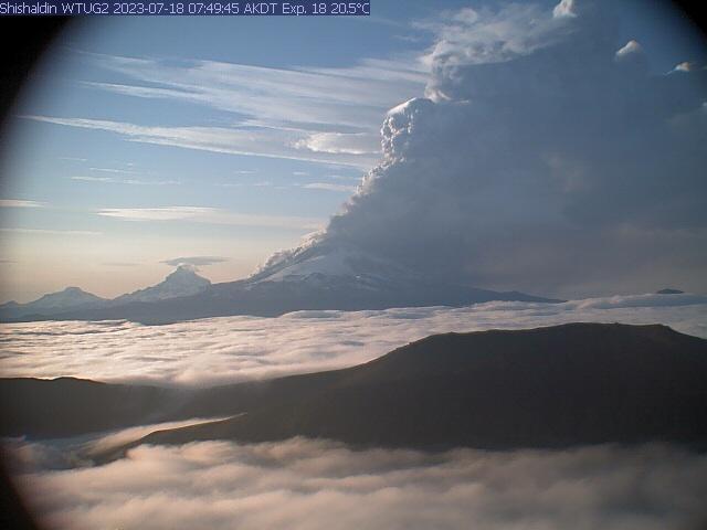
AVO is watching 7 volcanoes now. I don’t remember things being this high. If you zoom in on their base map they also load the map with earthquakes. The map for Trident shows hundreds of quakes. See https://www.avo.alaska.edu/activity/Trident.php and you can back up one level and look at the other 6.
I have taken a peek at the IRIS browser.
The Katmai cluster seems to be escalating, particularly in the Martin-Mageik area, here earthquakes seem to be at their highest during July, about 234 earthquakes catalogued this month so far, which is the highest yet in record I think. Probably due to increased hydrothermal activity driven by magma. Instead, Aniakchak and Tanaga have died down almost completely.
There are also a few minor swarms. Great Sitkin and Veniaminof have seen a subtle increase in deep seismic activity during July. Both of them are already erupting, I think. But the most remarkable is a Cleveland swarm of 24 earthquakes during 12-14 July that shows a clear spatial progression towards the volcano and upwards. Presumably a surge of magma or gas doing some deep conduit clearing. I don’t think of Cleveland as a noisy volcano, so it might be significant. Shishaldin, on the other hand, was completely quiet before the eruption.
When Kasatochi Island erupted on August 7, 2008, I had already been monitoring for about 2 weeks previous. What was totally fascinating was the string of quakes, showing magma movement from the Alaska trench all the way northward to Kasatochi and inferring rapid magma movement in hours, not days along a conduit. You could actually trace a feeder conduit by the quake lines. Finally the 10:30 am 5.8 quake hit and I wondered if the scientists were trapped on the island. Fortunately they escaped before the main eruption.
Interesting. It is a rare thing to see a clear progression along the conduit, but it can happen. Particularly when an old pipe conduit is reactivated, you seem to get these clear progression of earthquakes. At Piton de la Fournaise, when the volcano enters a period of high activity, after a more subdued phase, you have these spectacular swarms:
Not Veniaminof, Semisopochnoi, I switched them up.
The Mauna Loa deep earthquake activity is still continuing. We have another small flurry of 12 microearthquakes about 40 km deep, within 3 days, starting on July 15. There was a brief but intense pulse in late April, then it was almost completely quiet until the start of July. During July we’ve had almost continuous deep earthquakes under the summit of Mauna Loa, coming in small waves.
https://www.usgs.gov/volcanoes/mauna-loa/past-month-monitoring-data-mauna-loa
This drone video from yesterday answers a few of our questions https://www.youtube.com/watch?v=XwCDXipZeoE
yesterday I mentioned pumica possibly in the lava, but the drone video shows some type of unique lava, almost white in color at the top of channel flow. I wonder the chemical composition here?
It’s not a particular chemical composition. The highly liquid lava solidifies at the surface and forms a smooth and reflective layer which makes it look like white. But it is just a shimmering surface. Optical illusion, more or less. It was also observed in the 2021 eruption, at some days the cone looked like as it would have snowed.
You hit the nail on the head. It is easy to be fooled by optical illusions, and I probably was fooled 2 or 3 times, including this one. The sun angle made the lava appear rusty brown too, and I thought it had totally changed composition. No, it was the angle of illumination and interplay of the shadows and lit areas. Add to that a camera which is not exactly 4K HD definition, and anyone can be misled by the optical illusion.
Is it currently a lava fountain or still a fissure? Some videos/photos look like a short fissure of a few fountains, while other look like a singular lava fountain.
fissure fountains? 🙂
Shishaldin with Code Red today:
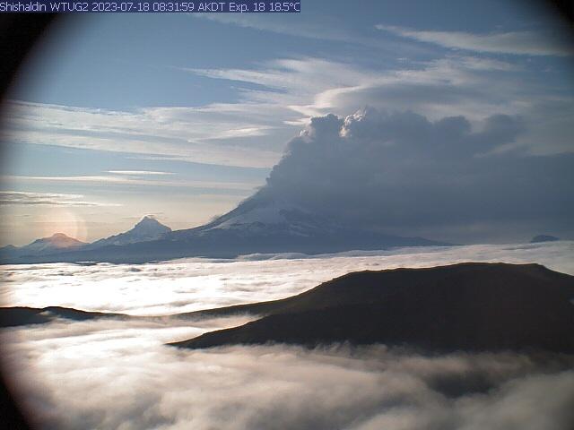
“An ash cloud with an initial height of around 30,000 ft. (7 km) above sea level from Shishaldin volcano began at 7:00 am AKDT (15:00 UTC) and is drifting SSE. The eruption is continuing and recent pilot observations estimated a 24,000 ft. (6 km) above sea level height. The aviation Color Code remains at RED and the Volcano Alert Level at WARNING. The National Weather Service has issued a SIGMET for this activity.
Eruptive activity began increasing overnight starting around 1 am AKDT (09:00 UTC) with increased lava eruption from or within the summit crater but no significant ash emissions. Activity was detected on regional infrasound arrays, increasing seismic tremor, and elevated surface temperatures in satellite data. Overnight webcam images confirmed glowing from the summit with only minor ash emission.”
https://avo.alaska.edu/activity/report_getter.php?need=current&id=403924&type=3
Great collection of informed musings, Lurk! Especially since yer taking about my backyard (sorta).
One of the most curious aspects of the crustal integrity of the area around Mt. Lassen is the number (over a dozen) of monogenic cones that populates the flatlands on the west side of the volcano (the cones east and north of Lassen are much more famous)/ From my research, most/all of these one-time volcanoes erupted on their own, and were not tied to any particular activity at or near Lassen.
I find this very curious. To me, their presence suggests that the crust west of Lassen is highly fractured at depth and prone to local “leaks”…and I’ve often thought that the ancient subduction to the west was not a smooth process with lots of crustal folding and buckling of the various layers/tufts that has created weaknesses that allows magma (basalt) to intrude to the surface. However, for some reason, this monogenic cone building does not exist elsewhere in the Cascadian volcanic zone, just primarily in the area of this most southern extension of the Cascades mountain range.
Craig, 3 or 4 weeks ago, I emailed a certain person informing them about the drop basin quakes occurring at Lake Alamanor, which is a drop block due to the faulting running through that area. I told him that I had a concern because the Coloumb stress was actually pushing towards Mt Lassen, and I told him that the quake activity would NOT die down but be more or less continuous from the initial point forward. And so it has turned out to be. I am hoping that the quake activity does not trigger the volcano in the next year or two, but I won’t be surprised if Mt Lassen reactivates.
See this https://photos.google.com/photo/AF1QipMsYsvSiGQeDegVgfBRLsWqDL51bt13rKRzm1UI
Randel, that’s a real interesting…I’m going to keep my eye on Mt Larsen now,the other eye on Iceland.
I tend to agree.
However, I contacted the USGS on this topic after noting the significant and sudden shift in GPS readings around Mt. Lassen since the start of 2023 … relatively commensurate with the time of the start of the main swarm under Lake Almanor (note the quakes continue, but at a lower rate).
They advised that the GPS readings showing a significant bump upwards and NW was “normal”, though I could not find any evidence in the archives of such rapid and large changes ever occurring?
We shall see.
Okay, new gusher starting at approx 22:46:53 pm and ramping up. Let’s see if this continues for about 100 mins.
I did recognize the fumeroling from the vents around the camera field of view as indicating a possible gusher ahead. Now it is occurring. See https://www.youtube.com/watch?v=yJfiMhqLgTY
You are right, quite strong activity at the moment. Fantastic sight in twilight.
The amount of material being throw out is adding to the cone’s outer diameter. The lava lake is in boiling cauldron mode at the moment.
Anoraks of Iceland. There appears to be one path along the hill, that passes right in front of the camera. One man even blocked the lens with his hand, ignoring the amazing spectacle behind him. The camera clearly is a magnet to muppets whose DNA needs to depart this world in peace.
If anyone in Iceland happens to read this, please tell site visitors to keep off the cameras? The world is watching your eruption!
The RUV camera would need to be fitted with a movable long pole with a boxing glove on the end, (like they used in the wall on the wipeout gameshow ) to deter the posers, or a loud attack alarm.
It would be interesting to know precisely where that camera is. It may be on a hill inside the red dashed lines which means that the directives of the ICE-SAR and other authorities are being ignored. The figure I saw two nights in a row was passing in front of the Litli-Hrutur cam. That’s out of bounds. There’s a small section on the map, on the NNW slope of Litli-Hrutur which is not enclosed by the boundary. They may be coming up from there.
The thing that is interesting is the lava channel doesnt really change, the gushers seem to be just when the point it flows out iofthe cone is higher. Possibly there is an outlet at the bottom that gets blocked periodically by the parts collapsing from the cone so lava rises and gushes over the lowest point that happens to also go in the same direction. But then the blockage clears. The output still seems to be continuous at the vent itself.
I keep thinking about this that the flow is continual but the level of lava does rise, that is obvious. We need more drone flights and observations to pin down why this is happening.
Backing up a bit, it’s obvious from the photo posted to that FB page you inquired of that people are climbing Litli-Hrutur which is out of bounds. What’s charming about the comments the followed is that either 99% of those contributors either don’t know, don’t care, or both. Personally, they should shut the whole site down to all but govt officials, science, and the media.
Exactly
Not sure which camera this is, but from this angle it looks like a vent or breakout is trying to happen on the back side of the cone.
Scrolling back, it looks like it starts around 02:51 and is pretty obvious around 02:53.
Oh, WOW.
The whole western side of the cone just collapsed.
Now THAT’s what I’ve been talking about since this all began. How many might have died in that.
Yeah, one does not outrun something like that.
The lava level inside the cone was very high, so I was expecting something like this to happen, but not quite on that scale.
Interesting how the sudden removal of support triggered smaller collapses all around the cone.
Thought it was getting more more active-night viewing can give that impression- the collapsed was a sight to behold!
04:10.
It starts between 04:11 and 04:12.
The lava becomes sparkly for a while as it spills out — what’s the deal with that?
And where will it go now? The original channel seems to be rapidly dying now, so presumably it’s all going west out the new breach now, but it’s not then curling around to the south, as one would expect if the terrain generally slopes that way. Is it going south along the west side of Litli Hrútur now? If so, what are the implications for it reaching the road or something else valuable?
Its flowing quickly over moss that relase combustable gases.. stunning sight how fast it flowed when the cone broke
So, what does that mean for the flow paths?
Does it now have a way to flow north, or will it just pond up behind the spatter ramparts for a while and then sneak around and flow south along the edge of the lava field?
The lava had already yesterday with the old river path started to flow east. This just makes it easier for it to go east. And east means after a few days going south on the east side of Meradalir. Going for the road east of the previous attempt.
It is also likely that lava will fill up the void between the old lava river and the hill sides to the west of the river. But that will likely not let the lava continue to flow towards Meradalir.
I expect the lava to flow south parallel to and west of the previous channel until it gets to the area where the old channel broadens; and then it will merge with the old flow, unless it finds a route back to the old channel sooner.
Wondering if now, because the flow isnt co fined in a channel, it could start to advance more as a pahoehoe flow and form a tube. It certainly isnt going to reach the ocean the original way now, it will take a slightly more easterly path. But for now it is likely to form a pond around the area it is filling at present, with potential for fast moving overflows.
The lava is also much much much much more viscous than in summer 2021, But this is a diffrent melt batch being erupted, forming slabby pahoehoe breakouts close to the ponds
Geldingadalir summer 2021 was as fluid as Hawaii, but it was a super primitive picrite melt with a crazy mgo content the current lava is very difftent and comming from a crystalizing mantle source
It isnt really more viscous, just more crystals as you said, and also that the eruption rate itself is high enough to force the transition to a’a either by fountaining or by forcing it to flow faster than it wants to. Also for the pond, it is likely that such a fast flow picked up a lot of the loose dirt and it probably also rapidly cooled itself with so much incandescent surface. So it is hot exactly too surprising it has formed slabby a’a. The lava now has a near identical composition to the lava erupted later in the 2021 eruption which was the superfluid stuff you talk about 🙂
Well is the magnesium as high as 2021 ? Looking at graphs from the geosicence data its not
MgO %wt. = 8.5. in the early analysis so as high as 2021, which had a range of 8.5 to 9.8 in the early part.
The even landsacpe make it difficult for lava to flow very fast. It’s like a volcano in Dutch landscape not in Alpine landsacpe. Steepness is one of many factors for lava’s speed.
In apparence its quite similar to Holuhraun.. fluid But not totaly aluminium smooth yet able to form near vent sheet pahoehoe overflows, but Holuhraun acually looks even more viscous than this as it was jam packed with small crystals
They strangley forms smooth ponds yet small spillovers turns instantly to Aa lava rather than sheet pahoehoe ( crystal content )
Still the overflow collapse was fluid like mad so I guess the melt viscosity itself is very low ( But having a high crystal content)
It looks like the lava now is pooling up at the west south-west and north-west side of the cone. Will it break out to the south or to the east? My bet is still on east. The path to the south is quite narrow and the cooling of the lava around the edges just makes it even narrower.
The cone looks like a big candle that’s border has collapsed and all the liquid wax floods the surrounding landscape. The lava flow to Meradalir has ceded now and lava has changed the direction towards SW.
The new lava flow direction will go through the passage between Litli Hrutur and the Thrainssköldur’s peak towards Kistufell and possibly Geldingadalir.
That way is uphill, most likely the lava will pond where it is and break out towards the east eventually, which is a shallow downhill gradient. But it is likely the flow will take a long time from now to form into a dominant channel liek before unless the original channel can be reoccupied, whic hwill direct lava at least some of the same way as before.
But if this goes on long enough, for months like in 2021, then this is not particularly consequential. In that timescale there will eventually be a cone as tall as Litli Hrutur surrounded in all directions by lava flows. If a tubed flow can form and stay active for a month or two then it is very likely to reach the ocean but other than that an ocean entry is unlikely.
This stream clearly shows the easiest way for the flow to go:
https://www.youtube.com/watch?v=LykVVU3C6D0
There is a substantial drop going to the east, as soon as it finds a path.
Geldingadalir no longer exists.. there is in principle a path around Fagra to the west and on to Grindavik. It is a long way. i think the flows will now first continue to build a shield, and decide which way to flow afterwards. It is pretty much contained for now
Yes, we should call it Geldingahraun. The even landscape makes it difficult for lava to flow very fast and find a direction.
The horse castration valley I think in translation
The flow to the SW has now seizzed, all lava is now pooled NW of the cone.
And just as I write this, there is a breakout to the SW from this lava lake.
🙂
https://www.facebook.com/reel/245748001557899
Looks like a huge flood of liquid copper 🙂 foundry
Ooo loves the burning gas bubbles from the moss adds an infernal look to it .. well looks very much like a foundry
Luckly No persons stood there when that happened
The peak of the Þráinsskjöldur is 238m above sea level. It may show a vertical limit for the Fagradalsfjall volcanoes. The 2023 vent collapsed before it could grow too much above this limit. The pre-eruptive base is 220m above sea level. The summit of the vent has risen approximately 30m above the base to 250m (asl.) on the crater wall. After the collapse this night the lava can exit the crater at maybe 230m (asl.).
Þráinsskjöldur pahoehoe Lasted perhaps 40 years and did well over 5 km3 so basicaly a Puu Oo but was probaly a product of decompression melting after the Ice Age
2021 we may have entered the beginning of 40 years or 100 years of eruption episodes which will add a new layer to the old Thrainsskjöldur shield. This would mean that we get an eruption on Iceland every year! We won’t have to wait for long five years until the next eruption on Iceland occures, but much more often. There will be years with two eruptions: Fagradalsfjall + another Icelandic volcano.
As I said this, Askja has made some earthquakes again, it still is in the game for the next eruption. How is inflation there now?
I’m seeing 30cm of uplift between September 2022 and July 2023.
A bit of speculation from my side, but I think the smoke outlet at the SW edge of the crater (that has been there for several dags) is the remains of one of the original cones. The location in the N of the cone that started the collapse tonight is definitely a separate cone that got buried by its larger southern neighbor (it was still visible as a small cone yesterday morning, on the north side of the cone). The main cone contains two separate openings, which we have seen as two gas outlets in the lava lake in the cone earlier.
The initiation of the collapse was actually a third thing, the lava tuunnel out of the cone got blocked and this raised the level of the lava lake in the cone, this increased the pressure on the walls and one could see cracks in the walls prior to the actual collapse. And when the cone collapsed, the pressure holding up the interior walls disappeared and parts of the walls fell inwards as well.
https://twitter.com/DottirGongu/status/1681580726775414784
Pics of volcano wall collapse
Hraunfoss : )
Kilauea since January has seen 20 cm of caldera extension and both CRIM and UWEV had moved upwards by 8-10 cm at the same time. UWEV is still lower than it was before the last eruption but CRIM has now almost recovered.
The caldera extension is unprecedented, the extension before 2018 was 30 cm in 5 years, which I thought was a lot then. But we are at 2/3 of that in 6 months, despite an eruption in that timeframe…
They are under a tropical storm warning. Expect the GPS and tilt to be affected by rain for the next days
This is 6 months of movement up to now, nothing to do with a future storm warning. And rain affects tiltmeters, not the GPS, which are manually reviewed almost daily.
Actually the GPS is affected. excessive moisture in the atmosphere affects the signal delay time, but that can be calibrated out. Soaking ground expands and that can push up the area with the GPS. So be cautious with any ‘signal’ over the next few days, as you cannot be sure. You are right that the tilt can be affected more, because rain may push up the ground on one side more than the other, but the GPS is not immune. At least we don’t have the Icelandic problem with snow on the antenna!
Yes but that wont change any of the data that is already on the graph, except maybe the last few plots. Although I believe all of the plots on the graph displayed on the website are already manually reviewed so are accurate.
For some reason I woke up around 12:30 am my time and checked and was stunned to see the changes and collapse of the cone. Interesting at 06:32:11 am you can a small fleck of orange hot lava exposed on the canyon wall to the right where the previous channel was, then finally at 06:32:32 am there is partial cliff collapse and all that still red-hot lava is exposed.
I also had 2 of my hypotheses exposed as incorrect, due to the cone collapse. The smoke emission from the cone is NOT due to lava hydrostatic (help me here, magmastatic?) pressure as can now be seen from the two smoky areas on the cone resuming their previous behavior. So much for my hypthoses that this was due to excess pressure
Interesting that the northmost vent seems to have such down, the last sputter at 07:49:38 am then quiet. The output seems subdued from the previous time period 4:30 am to say 7:30 am or so. I also notice that the lava has hardened enough in viscosity that the most recent flows are receding back towards the cone in regard to breakouts along the margins.
Cone collapse, from the RUV camera. The collapse happens about 30 seconds in
Spectacular, thanks Albert.