
Columbia flood basalt. Copyright Marli Miller, https://geologypics.com, educational, non-commercial usage
Greetings. This article has a long history of not being written. It originated a few years ago when the 2018 lower Puna eruption was on going. Before I start, let me vent. IN MY OPINION, there is no such thing as a “Supervolcano”. That term was popularised by the BBC for their disaster movie of the same name, released in 2005. Oddly, Wikipedia nails it. “It is based on the speculated and potential eruption of the volcanic Yellowstone Caldera” (bold added). As far as entertainment value, it’s passable (sort of)… as volcano disaster movies go, it beats ‘Dante’s Peak’ where a pickup truck crashing into a cave can save you from a pyroclastic flow! (Not to mention Cris Pratt and the dinosaurs outpacing one in a Jurassic World movie) -> not his fault, he just does the acting.
The term ‘supervolcano’ doesn’t even have a definition that can be tested. Amazingly, it was first used for the Three Sisters! At one time in the early 1900’s it was proposed that the Three Sisters were one volcano. This was proven wrong in the mid-1900’s, and in a discussion of this proof, the term ‘super’volcano was first used – to describe something that did not exist! Like ‘Big Bang’, it was a term coined to sound silly.
Later (much later) the word ‘supereruption’ became in use for VEI-8 eruptions, and after that a ‘supervolcano’ was one capable of a ‘supereruption’. That is not helpful either. To know it is capable it should have done one. But a supereruption obliterates the original volcano and leaves a very large hole in the ground – a caldera. Are the myriad large calderas of Hokkaido supervolcanoes? How about the collection of large calderas on Rabul? The three calderas of the Los Frailes volcanic complex in southern Spain? See https://www.usgs.gov/news/a-personal-commentary-why-i-dislike-term-supervolcano-and-what-we-should-be-saying-instead who argue that ‘supereruption’ is definable, but ‘supervolcano’ is not. That comes from YVO, so they should know!
A more accurate term is “Large Caldera Eruption”. With that term, all an eruption has to do is be in the upper half of caldera forming eruptions. A good reference would be the table of data compiled by Dr Peter L Ward that documents pretty near every major eruption for the past few million years. Find the size of the listed calderas, and the upper half of the size would be the large calderas. Spoiler alert, there are a lot more than you would expect. A clue for the doom mongers…. Yellowstone is not currently erupting, nor does it seem to be in a run up phase to do so. Tondano, a large caldera system in Indonesia, has frequent eruptions yet the doom mongers never seem to notice.
To quote Carl le Strange from a previous incarnation of VolcanoCafe:
“Some volcanoes just can’t catch a break. Imagine for a little while that you are a bona-fidé supervolcano. You are the largest of your type on the planet, you are highly active, and by gosh you have shown what you are capable of. In a perfect world your 20 by 30 km caldera explosion should have put the world into awe, and the 1,000 cubic kilometer of DRE you ejected in the form of pumacious tuff covers an entire sub-continent. Yep, you really did reach the small highly exclusive club of VEI-8 volcanoes. You smirk at your little sibling Monte Somma’s antics with Vesuvius. Your Vesuvius-style event left a 3.5 by 5 km God honest caldera on its own. To top it off you have a huge underground reservoir of liquid acid that would seriously alter the planets weather if you felt like discharging it. You are also perfectly located to have a maximum kill ratio. So, you wake up and stretch your arms and start a double eruption from two different sub-volcanoes just to celebrate the new day. You have your largest eruption in recorded history. Then you look around to see the fearful faces of the residents as they offer up motorcycles in your name, you expect volcanologists doing somersaults as they play lip banjo, and literally thousands of blog pages glorifying your power and shear awesomeness. What do you find? Yawning people and a cockerel trying to wake up a pig sty. You find that for being an erupting supervolcano you are a massive PR failure. One single small earthquake at Yellowstone outperforms you in publicity.” (September 27, 2012).
And yes, as large calderas go, Tondano is MASSIVE. But that is not why I’m writing this.

Source: USGS. The extent of the Columbia River Basalt group. https://www.usgs.gov/observatories/cvo/columbia-river-basalt-group-stretches-oregon-idaho
I have long had an interest in the Columbia flood basalts. This is a young flood basalt which covers Washington, Oregon and bits of Idaho and Nevada – making it a ‘small’ flood basalt. It erupted 16 million years ago, over a period of about 1 million years. The oldest part is at Steens mountain, at the southern end of the Columbia flood basalt. This is also near the start of the hot spot trail that left seven volcanic fields with large calderas, starting at McDermitt (16.5 million years ago) and stretching all over Idaho before ending (?) at Yellowstone (2 million years ago). Where did the hot spot come from? The trail prior to 16 million years has not just gone cold, it isn’t there. And how did a flood basalt morph into an explosive large caldera trail?

My original thinking was that the magma upwelling behind the detaching Farallon Plate after it’s full subduction had caused it. There is a high probability that that was wrong. My current thinking, based on several videos by Nick Zenter (the chalk board guy at Central Washington University), is that the Yellowstone hot spot used to be the nexus of an island, not dissimilar to Iceland, that subducted/accreted and eventually tracked to it’s current location. Whether it was part of an island chain or a ribbon continent depends on what paper you read. Accreted terrane is accreted terrane. Through petrological analysis of the accreted complexes it is evident that several sequences have been plastered onto the North American craton. Zircon analysis show that some sources originated from the west as well as the east.
While watching some of Zentner’s videos, I learned of an isotropic characteristic that tells whether a magma erupted through an accretionary complex, or through a craton. Essentially, the Strontium 0.706 line denotes the boundary of the North American Craton. This is the line where the 87Sr/86Sr ratio changes from below to above this value: the higher values are found where there is continental crust. (It is the green line in the plot, derived from multiple sources, principally USGS data.) It is in effect where North America ends and the accreted terranes begin. Notice that the Large Caldera events did not begin until the hotspot had passed under the North American craton, with all of it’s continental sticky silica. Steens Mountain, linked to the Columbia Flood basalts, is on the other side.

(There is disagreement whether this line is the edge of the North American craton or of continental crust in general. But that is not the main point. It shows where there is mainly oceanic crust or mainly continental crust regardless of their precise origin.)
Something interesting happens when you look at the 4.5 km geothermal potential;
 Take a look near Redding California. South of there is the Mendicino National forest. Coincidentally, near there is the Mendicino triple junction, the northern end of the San Andreas strike-slip fault. What else is at or near Mendicino? (From a quick Google search) “The Geysers is the world’s largest geothermal field, containing a complex of 18 geothermal power plants, drawing steam from more than 350 wells.” Strangely enough, that bar of elevated geothermal potential seems to point at the well known track of the Yellowstone hot spot. From my previous plotting frenzy during the lower Puna eruption, I estimated the Yellowstone hotspot as being located just off the coast of California/Oregon area about 30 million years ago. This fits with other work I have seen by actual geologists. I attempted to recreate that plot for this article, but failed spectacularly. I didn’t have time to back out the relative plate motions since then. (Either way, my calculations were off by an easy 1% in distance alone and my bearing calculations were horrendous.)
After watching a series of Nick Zentner’s videos, I have come to the conclusion that the Yellowstone hot spot, at one time was the forming mechanism of an island not unlike Iceland. Zentner relates three possible ideas of what collided with the North American craton. They range from an island chain, to a super terrane, somewhat continental in nature. Continents can be quite diminutive. New Zealand is a good example. “Zealandia” is a proposed submerged continent with only New Zealand itself still above water. Palawan Island in the Philippines is a crustal shard that detached from Asia quite some time ago. Mindoro Island being the eastern end that is currently smashing into the Philippines near the mobile belt. (See my “Sleeper Fish” article on VC from years ago). Other things that come up in Zentner’s videos is that multiple subduction zones and terranes have accumulated, building Washington State and Oregon much like an encrustation of bugs on a windshield… complete with carbonate platforms from ex reef system when the islands were bopping around out in the south pacific. The “Baja BC” idea stems from palaeomagnetic evidence that shows many of Washington State and Oregon’s plutons and rock structures originated as much as 3000 miles south of their current latitude. (Hence the “Baja” part of the term)
My contention is that SOMETHING… sort of a cross between Iceland and the Philippines, impacted the North American craton. I say Philippines because it currently has both eastward and westward subduction occurring on either side and serves as a good example of you can have both forms of subduction on an island chain. Siletzia, or the previous terranes, (Insular etc.) existed as a hotspot driven island/continent at the focus of at least one spreading center with other crustal boundaries attached. The long departed Kula plate was likely the northern plate of that spreading center. What other hot spot sits in a spreading center? Iceland.

My apologies for harping on the Philippine example. I have been a bit obsessed by the battle of Samar Island, the location of probably the stupidest tactical blunder I have ever heard of. {Not really Admiral Kurita’s fault, he was inundated by the details of conflicting information from the fog of war. He made his decisions based on mission guidelines handed down to him by bureaucrats and what he had at hand for intelligence… plus what he could see for himself}
It turns out that similar ideas to mine had already been proposed. Siletzia accreted on western America around 50 million years ago. It still forms the west side, extending underneath part of the Cascades. After accreting, the terrane rotated by 75 degrees. It has made things rather complicated. Siletzia is a flood basalt, older than the Columbia basalt and also much larger. It is dated to 50-55 million years ago. The suggestion has been made that it was formed at the Kula-Fallaron spreading ridge and that the Yellowstone hot spot was at the right place at the right time. This was the original Iceland (or at least a subtropical version), which 8 million years later was plastered onto America. See Wells et al 2014.

From Wells et al., 2014: accretion of Siletiza and Yakutat (Y). YHS indicates the possible locations of the Yellowstone hot spot
The Columbia flood basalt still needs an explanation. One suggestion (Wells) is that the hot spot was reactivated by slab rollback, and melted through the Siletzia basalt. But the main point made here is that shortly after, the Yellowstone hot spot entered the area of the old continental plate and that this started the sequence of large caldera eruptions.
Getting away from that, in Idaho, north of the Yellowstone HS track, is a mining district that produces ample silver and gold from the mineralization of emplaced plutons. These are likely the result of the YHP pushing magma up that never actually erupted. The mineralization following a process similar to the Los Frailes caldera systems of southern Spain (not quite as stupendous as Yellowstone, but large calderas unto themselves.) A USGS article on the topic.
How all of this relates to the formation of the Rocky Mountains and the formation of the Basin and Range province I’ll leave up to Mr Zentner’s videos. My advice is to load up on coffee and clear your schedule for an afternoon or so. They are fascinating.
One final item. The Philippines is claimed by Wikipedia to encompass around 120,000 sq miles of land. Washington State – 66,544 sq miles, Oregon – 95,997 sq miles. So whatever actually collided (or was run over by North America) was just a bit larger than the Philippines, possibly even twice that size since much of it is splattered across British Columbia and up into Alaska. Something else to consider. Some theropods were enormous. The first ACTUAL dinosaur bone found in Washington state was on an island near Vancouver. In my book, that goes a long way in calling the colliding land mass a small continent… unless dinosaurs similar to T-Rex were adept open ocean swimmers.
If you wish to study this further, I recommend Nick Zentner’s collection of references on Baja BC.
For his videos: Eocene A to Z is quite informative.
By the way, when it comes to the idea that Yellowstone is over due… in my opinion that is “bovine excrement.” Look at the time periods of the known Yellowstone originated large caldera events, you get a “due” date period of about 3.54 to 2.97 million years at the 90% confidence interval. At best you will get yet ANOTHER caldera infill event as the caldera floor gets paved over. If you don’t have a good lid on the pot, you are not going to get over pressurization. Maar style eruptions? Yes, that is possible. West Thumb is one such feature in Yellowstone lake. And as you know, volcanoes tend to erupt in a similar manner as they have previously done. Years ago, I tracked one collection of seismic events NE through Yellowstone lake up towards “Fishing Bridge.” I believe underwater surveys found pillow lavas down there some time before that. For those that don’t know, the “moon-bat” community was frantic that we were all going to die. I know because I was reading many of their discussion forums.
I have been advised to write a closing statement. This is difficult to do. I have the unfortunate characteristic of not being able to shut up once I have made my point. The best that I can do is to tell you that there is a huge amount of stuff that is far more entertaining than what you find on the TV. You just have to dig around on the internet to find the relevant papers. Some of what I did not address is the La Garita caldera in Colorado. My initial feel is that it was formed due to decompression melt from the crinkling of the North American craton as the various terranes accreted. Additionally, how did the Meteor hotspot get on the other side of the Atlantic spreading center? It has been implicated at reactivating the Reelfoot Rift, a precambrian weakness that was in competition at becoming the Atlantic Basin when it opened up about 200 myr ago. Back during the Atlantic Basin’s early life is when the Canary Islands began forming. They sit on top of phyllite. Metamorphed basin sediment. (The white part of the “floaters” from La Restinga pumice).
In short, if you have a question about geophysical processes. The data is out there, all you have to do is go find it. If we can’t answer it here, someone has probably already written a paper on the topic.
Many thanks to Albert for kicking me in the arse to get up and actually write this article that I have had rolling around in the back of my head for years. Additionally, he helped smooth out some of my disjointed thoughts on the matter.
Geolurking, July 2023


Judging from past collapses, I’m of the thought that the NE area of the cone would be next….they appear to be moving in a clockwise direction…?
Assuming that weaknesses are equally likely anywhere on the cone, the most likely spot for a collapse will be wherever the outer walls are steepest. Both collapses so far have happened where the walls were steepest, so my bet would be on that trend continuing.
And now proof that other volcanoes also deserve some attention: NASA published this satellite picture of Shishaldin’s recent eruption:
The pictures is embedded in a small article:
https://earthobservatory.nasa.gov/images/151619/shishaldin-erupts
Although the statement “An eruption on July 18 generated another large ash cloud that led the National Weather Service to issue a warning to pilots to avoid the area. Plumes of volcanic ash can contain sharp objects that can damage jet engines” seemed to be a bit off.
The Icelandic Institute of Natural History and The National Land Survey of Iceland published a new 3D model of the Litli-Hrútur eruption site with data from July 23rd:
https://sketchfab.com/3d-models/fagradalsfjall-litli-hrutur-2023-692812941dbc40319853c532db113f84
Being able to view the lava flow field and the active cone in 3D naturally gives a better impression of the eruption so far than all the 2D webcams.
Sad that it is already out of date by the cone collapse yesterday. It still gives you a good overview though and we can see on the cams where the new laval flow went.
Yeah, that’s a principal problem for all such mapping exercises that the data are a bit outdated the moment you collected them. Add a day or two of processing and you’re slipping away from the present state even more.
However, without these efforts we wouldn’t have any permanent snapshots of the different stages of the eruption. Every once in a while I like to go back to their recordings of the 2021 eruption to see how the lava flooded the different valleys and hills.
The 2023 eruption is adding another interesting wrinkle to the whole picture.
AVO is reporting unrest at Trident volcano with inflation, tremor and magma accumulating at 5 km depth. There is a 50% chance of an eruption in the next months to years, based on how often such events in general lead to volcanic activity. Trident is next to Novarupta
Very intrigued by this whole scenario, and here is a nice overview article from The Watchers dated today:
https://watchers.news/2023/07/25/magma-intrusion-at-trident-volcano-site-of-the-worlds-largest-eruption-of-20th-century-alaska/
I find the Katmai complex extremely curious. The volume of the Katmai caldera is supposedly 5.5km^3 yet Novarupta released quite a bit more magma than that. Where did it come from? A deep source, that is linked between the other systems in the complex? How much magma is down there?
Maybe this will just be a small-ish effusive event from Trident, I just find the whole complex very interesting. Novarupta was a weird event IMO.
No small event! I want Novarupta 2.0! I want to see an intense 15 km3 DRE explosive eruption! The volcano is extremely remote so an large eruption wouldn’t hurt anyone, and I don’t fly planes so bring it on baby!
You might not like a volcanic winter so much …
Novarupta did not cause much cooling, so a slightly larger eruption in this system should not cause a volcanic winter. According to Tallis, Novarupta was VSI 1.5.
Much smaller eruptions than Novaruptacan cause detectable global cooling, such as El Chichon, so that’s not a hard and fast rule. Size alone does not tell you much of a surface cooling effect an event will have.
Take a look at the radiative forcing in the early 1900’s on the graphic on the second page of this paper:
https://journals.ametsoc.org/view/journals/clim/13/9/1520-0442_2000_013_1445_lofcsv_2.0.co_2.xml?tab_body=pdf
According to this graphic, radiative forcing after Novarupta eruption was similar to that after El Chichon eruption. El Chichon was more sulfur-rich and occurred near the equator. That’s why I’m afraid of a possible CCN eruption. Eruptions in this region tend to be sulfur-rich and the CCN is located almost at the equator.
A larger eruption (Pinatubo size) in Alaska may depress global temperatures by perhaps 0.5C. This would put us back about 2 decades to the early 2000’s. It is moderation of global warming but not a reset, and of course it is for 1-2 years only. Local variations may be much larger. Alaska would mainly affect higher latitudes in the northern hemisphere. Europe might be most affected. And Greenland – it is what I thought played a role in the failure of the viking colonies, the fact that that particular area is very sensitive to volcanic cooling
Re:”The volcano is extremely remote so an large eruption wouldn’t hurt anyone,.’ Disagree! Need I remind you of my comments on access to restricted areas. There was even an article in the local paper acknowledging the fact that Litli-Hrutur was the location most hikers were seeking. Your understandable enthusiasm is not for this event. IMHO, not remote enough to avoid significantly impacting the cities, towns, and infrastructure.
Tallis was commenting on Trident rather than Reykjanes. You may mean that what are seeing at Reykjanes could apply to Trident, with people going in just to have a better (and terminal) look. That would actually fit with the reputation some Alaskans have. But as for a large explosive eruption, there would be many worse sites than Trident.
Clarification appreciated.
How do you envision a Novarupta 2.0 impacting this region?
https://www.esa.int/Applications/Observing_the_Earth/Litli-Hrutur_eruption_seen_from_space?fbclid=IwAR3_4CS_jCg8C399pq6MYD-JSNipF5Yd9eM_CcBg8s12AYFwlmnHrwyAkNw
Tallis, I’m with you man.
I have spent an uncomfortable number of hours staring at what images of large explosive eruption plumes exist. I’ve spent hours looking at the macro, zoomed out image of St Helens and trying to imagine larger eruptions at that same scale (and yes, I know in many cases it comes down more to duration than absolute size, but still).
I don’t want to see anyone hurt, and am more than happy to view the bang of a remote volcano.
HTHH felt like a tease bc although it was a spectacular eruption with an enormous plume, the majority of the imagery was from satellites with very little documentation of the ground level plume (for the best!).
I really would love to view a feed from a safe distance of a true, typical VEI 6. Pinatubo or greater, with the climactic blasts recorded.
It’s almost titillating thinking about. I get Jesper’s fascination with Ionian volcanism; I just lean towards the same inclination for explosive events. The mechanisms, forces, resultant impacts, it’s all just bewilderingly fascinating to me.
OMG yes same 😀 You’ve just read my thoughts hahahaha
Explosive/felsic guys of the world, unite!
Ground video of an incredible explosive eruption akin to Tonga or Krakatoa is something that I’ve longed for years. We’ll have our moment comrades in due time…
I mean,realistically there us probably not much to see, any distance close enough to see the same structures and features as we get in a VEI 4-5 would be too close in anything 6+. Or even in a high 5, like HTHH was.
All you would see is a wall of glowing ash racing towards you, with the sky behind that being filled with a grey abyss of ash going up probably over 10 km or more. It would be like the St Helens lateral blast, but twice as far and in all directions at the same time. Its not a dangerous visual spectacle but a literal apocalypse, you could be 50 km away, you wouldnt see the eruption start or anything interesting at all but it would still get you.
Ignimbrite eruptions are probably all comparably powerful, it is the evacuation of a magma chamber in totality under the force of gravuty, the variable is the volume. If anything smaller examples are more powerful because they have a larger vent size to chamber size ratio, so can evacuate faster. HTHH reached 50 km up and 80 km sideways, underwater. Yellowstone or Toba would be that but it lasts for a week instead of an hour. The scary thing is HTHH broke every rule in the book, it is a young mafic stratovolcano with a small caldera that has been highly active in historic time. By comparison we have Chaiten that is a rhyolitic volcano with centuries between eruptions, only managing a 4. In fact out of all of the eruptions over 1 km3 in the last century only two were felsic and neither were ignimbritic.
Lets go bois!!! 😀
soon tm
Tell me, would a volcanic winter caused by a big eruption in that complex stop those heatwaves on the west coast and also the east coast? Wondering.
if it’s big enough it definitely would. Extra-tropical eruptions don’t have to be as large as tropical eruptions to have the same impact on the NH by virtue of not having to share it’s material with the SH. Extra-tropical eruption have produced some of the most extreme volcanic winters in history(1783, 536, and 44 B.C) so of course if it’s too big,you’ll have to worry about summer cold waves! Katmai complex doesn’t seem to release that much sulfur in it’s eruptions so I wouldn’t bet on it.
Additionally…. the Tropopause at higher latitudes is far easier to reach. Nt as much work is needed to inject SO2 into the stratosphere.
(And Thank You to whoever fixed my access to VC. I had to rely on other admins to move this article over here.)
Ryan Ionian events are quite explosive too, the magmatic sulfur gas in Ionian basalt will decompress violently as a fast moving dyke reach the surface driving some incredibley large lava fountains that are more like plinian eruptions.
Dykes may also become very violent If the hot magma gets intruded in thick layers of sulfur Ice ( think Gjalp 1996 But with sulfur yellow Ice instead )
But there are also gas poor gentle Ionian eruptions like lava lakes and gentle flowing Ionian lava flows, they are often violent when the hot lava flows over sulfur Ice causing basaltic flows to explode at their fronts
Definitely true, I actually can’t wait for your next article on exo-volcanology!
RUV’s Driffellshraun video has gone off-line at 19:44 and been replaced with the Nordur feed.
Isak is using a heat detector on his drone, looking at the junction of old and new lava in Meradadalir. 22.50 GMT.
https://youtube.com/live/y_pOCS0-EH4?feature=share8
And he zoomed in on a flowing lava tube with breakouts in the skylight and displayed dendritic formations on the slightly jiggling objects standing against the yellow hot flow. I have never seen these curious dendritric condensates before, it was a surprise seeing them everywhere including the roof of the flow channel. I think most people were surprised seeing them for the first time.
They are called lavacicles 🙂
They are actually a well described phenomenon in Hawaii. I guess because eruptions creating pahoehoe with lava tubes are uncommon in Iceland it is not so well known there.
Chad, the dendritic growths were vapor deposited and grew dendritically like a snowflake structure, people commented on it. I have seen the lava icecycles from both Hawaii and Le Piton de la Fournaise, which come from very hot lava splashed on a ceiling and then dripping off like a cave stalactite, but these growths in the lava channel tonight were not from a splashing effect but vapor deposition is how I would best describe it.
Yes those are still lavacicles, they form from limited remelting of the tube roof, the ones that look like thicker blobs are when the tube fills completely and receeds. I imagine the melt involved is different from the original basalt somehow,maybe highly enriched in the incompatible elements so forms a melt with a much lower viscosity but only tiny amounts of it, seeping out from between crystals of the hardening wall rock of the tube. But this is all only my hypothesis.
Not vapour. Volcanoes may be hot enough for molten rock, but vaporizing rock is something else. That requires far higher temperatures
Vapor deposits of lava? That’s almost impossible… chemical and physical wise.
Albert and Chad, please take a look at this photo. https://photos.google.com/u/1/photo/AF1QipOFK1uHlhW6b_9UPiwfIRxKp2W40xCBgP-lu3ss. The dendrites were like moss growths and shook a bit like waving leafs. One segment which Isak filmed showed a drop down block stuck in the yellow hot lava stream and interesting dendritic growths were on the sides of this block but it was above the flowing lava level. There were a lot of comments from people including Isak himself when we saw this.
I did not say vaporizing rock. Lava does carry lower melting volatiles, such as sulfur and other compounds, and they can be in vapor form at 1190 deg C lava temps that was cited for the current lava temperatures.
Can´t access that image for whatever reason, but I guess you mean dendritic lava:
https://www.facebook.com/USGSVolcanoes/photos/a.984262971602264/1228202930541599/?type=3&locale=ar_AR
https://caves.org/virtualcave/mineral-deposits/
Could it have to do with ferromagnetic properties of lava? The shape of dendritic lava loosely reminds of the shapes that iron sand makes when influenced by magnets. Basaltic lava contains abundant iron as cations.
I can’t access the photo. Yes, I thought you might have meant other volatiles. To get long structures such as dendrites, you either need to create crystals with that shape (which depend on the mineral) or start with a liquid. Here, the latter seems needed. The melting and boiling temperature of sulphur could fit, but expose it to the radiated heat of the much hotter lava and it will quickly evaporate. I would guess that these are lava deposits, and either the lava levels in the tunnel have varied and are now a bit lower than before, or there was some liquid (lava) above the tunnel which dripped in over the edge.
One might consider crystal growth occurring in the solid, but hot, and with likely high diffusion rates of some chemical species. You do not need vapour or evaporation for recrystallisation to proceed.
Rock Vapour makes me think of the Hadean Era when the entire planet had an rock vapour ”photosphere” atmosphere as hot as the sun because of giant impacts.. a hellish place for soure
The eruption is a hello from those times at least the heat is 🙂
Pahoehoe is incredibley common in Iceland, most of large Icelandic lava fields have been formed by decades, perhaps 100 s of years long pahoehoe eruptions a major component of holocene ground
Its just that souch eruptions have not been very common at all since Iceland was colonized, the last time there was any Icelandic flows really like 61G was surtseys tube feed phase in 1964
The current eruption seems to do doing a pahoehoe phase now with lava tubes being established, we will see If a pahoehoe flow field will develop now
Pahoehoe flows are very well insulated and can flow wast distances
The lava is very fluid at the vent and looks like viscosity is lowering yet it still does not look exactly as fluid as Nyiragongo or Kilauea even at 1190 c
Coud this be because the crystal content is higher than Hawaii yet with same temperatures?
Looks like we’re back to a full lava lake and the south vent sputtering a Strombolian eruption on the side. See https://www.youtube.com/watch?v=yJfiMhqLgTY 01:17 am Iceland time. The last time this happened we had a north vent collapse and a gusher down the cone into the field lighting all the moss on fire.
At 04:22 the three small blowholes up the south flank of the cone are getting ready to make noise.
It is obvious that the gas pressure in the fissure cone is lessening, guaged by the size of the lava bubbles blown in the lake and their height. In fact just today there are relative moments of almost calm.
It will be interesting to see if surging or geyser action develops after we lose the hydrostatic balance of the gas pressure against the lava weight in both the lake and the top 1000 ft or so of the active conduits (and I still cannot tell if there are 5-7 vents active)
My guess is that soon we will start to see geysering in the cone, but I could be wrong too.
Is it gas pressure or magmatic pressure that decreases? If the magmatic pressure decreases, then the volcano would need to rely on gas pressure to uphold the eruption. A consequence may be the “Geysir action” or some kind of hawaiian-strombolian tendency.
One big unknown is at what depth does the gas come out of solution? We can see the big bubble explosions at the surface or just below the surface of the lake and it is obvious that the gas is in free form and still expanding from the heat. But it has to come out of solution somewhere and this is still an unknown factor here as to depth. I remember watching a couple, Alexander Belousov and Marina Belousova put together an underwater camera and then putting it into a geyser and trying to sink it down further in order to watch the action, and there were surprises when they watched the camera. See https://www.youtube.com/watch?v=G_0ClrLzrqM
Very interesting video. A rare look at the insides of a geyser.
Does anyone know if someone is running fibre-optic DAS (distributed acoustic sensing) experiments on the Reykjanes Peninsula? That could potentially give great insight into what’s happening near Keilir.
I know there have been experiments done at Grímsvötn. See for instance this link:
https://www.seismosoc.org/news/fiber-optic-sensing-detects-tremor-from-icelandic-subglacial-volcano/
Also, check out this video, found in that link:
https://youtu.be/J7cxVZvgyWQ
Pretty sure they have used DAS technology already in Reykjanes, I think there are already articles published about that.
Tomas, you can write the corresponding author at https://pubs.geoscienceworld.org/ssa/tsr/article/2/3/148/615007/Fiber-Optic-Observation-of-Volcanic-Tremor-through and ask Andreas if he knows anything else going on in Iceland at the moment.
In response to Hector’s post just below, yes, others are doing this, see https://www.nature.com/articles/s41467-018-04860-y so I guess it is simply trying to find the people in the know at the moment. I wouldn’t be surprised if the IMO has been thinking about this.
From the nature article, the green is the fiber optic cable
I would not be surprised if this might be used right now for this purpose.
Was that not the fibre cable that got buried during Fagradalsfjall season 1?
No, that one was a communications line buried alongside the south coast road. The one in the map above is specifically for seismological research and passes well to the north of the eruptive sites from the last three years.
https://twitter.com/JBCOYS99/status/1683967820483424257
From the Iceland Geology | Seismic & Volcanic Activity in Iceland page on Facebook
This is one scenario that we do not want to happen
https://vafri.is/quake/?fbclid=IwAR33oDkBG7cpWKJ8Ca-6uEHi6RYRZ0w9WQdUoVA5IRzzwemvwWmBMb9QA2A#close
Still quite some earthquakes deeper under Keilir, it was like this back when the dike was growing but I assumed it stopped some time in the first week of the eruption, apaprently not… If this represents a magma conduit and possibly pressure on the walls, as appears to be the case in the rift connectors of Kilauea which are similar structures (albeit horizontal), then the low output of the existing vent is not a good sign, other fissures are probably going to open at some point.
Also, even at the current output, if the flow forms a tube it can still easily reach the ocean and coastal road. It will take a while, probably weeks or maybe a month or two, but 8 m3/s is at least twice the rate of effusion that fed Pu’u O’o flows, all of which easily flowed into the ocean some 12-13 km distant, or in the case of the 2014 flow it got 24 km before it stalled. The ocean is only 10 km at best from the current vent, and presuambly all of the lava now is going into the interior of the flow field, so it could take a short cut and start oozing out of the more distal areas as fluid a’a or pahoehoe instead of flowing that far again, which would cut the travel time down by at least 25%, possibly more as the topography is quite confining beyond that..
Yes and it should form fluid hawaiian pahoehoe now? have any smooth pahoehoe field been starting to advance yet ?
Perhaps the tubes is feeding into Aa
Wherever it is flowing it isnt getting to the surface yet, it is probably inflating the flow field. So it could really break out anywhere along the edge.
The lava level in the cone is very high now (23:01).
In trying to chase down earthquake shadows, I came across this post on June 7th, 2023 by Albert – see as the the possible location of the fissure eruption.
Albert’s guess is astonishing good, and it is worth posting to Volcano Cafe in hindsight.
It always seems to take quite awhile for the satellite photos to go public. Here’s a July 11th shot of the eruption start take by ESA.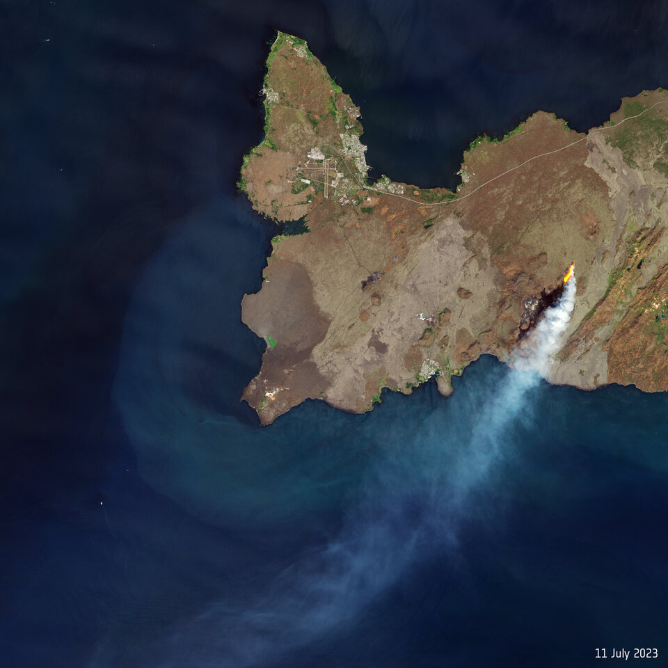
Is science only to be done by a select few?
This evening I discovered a certain scientist in Iceland who was looking at the same identical data I was looking at on July 11th, including the very same camera and very same seimic trace and the same quake epicenters, but Twitter has and is blocking me from even establishing an account so that I can look at this scientists tweets. He is studying the inSAR data for the area near Trolladyngja right now and he’s intensely interested in the ODF highpass fluctuations.
It is frustrating to me that I cannot even look at his tweets. For some reason Twitter has decided that I cannot view his tweets.
You mean “X”?
Haven’t you reached the maximum number of tweets that you are aallowed to watch per day (unless buying a subscription)?
If I cannot even log in to twitter to even get a subscription, how am I going to qualify for viewing tweets? And if I cannot even pull up one tweet by looking at the find from a search engine and clicking on the link, to view the tweet and that is being blocked, how can a person overcome that?
Thank you for your comment.
I am so glad I am not on social media. Apart from VC, of course.
And even that can be infuriating. Albert has to deal with my inane ramblings… but he did convince me to finally write this article.
You can use nitter.net. Then you don’t have to be logged in at all. Just type in the username of who you want to read from. It works now as long twitter doesn’t change again.
Alas, twitter is still restricting access. See https://drive.google.com/file/d/1CDulba3iJSrF34Nnqui_e2qzvBrInVAA/view?usp=sharing
But thank you for the tip.
The Iceland eruption is now competely tube feed a skylight can be seen on this webcam https://m.youtube.com/live/yJfiMhqLgTY?feature=share
The other chimneys that are visible also seems to be connected to tubes based on the previous flows (while being visible). Drone footage needed to get confirmation of course.
How long can the volcano sustain the lava lake in the crater? https://www.youtube.com/watch?v=yJfiMhqLgTY
If we are lucky this can last decades but probaly a few years or months is more likley, But its a shield eruption now ( a small one )
The longest lived Icelandic shields lasted 100 s of years
https://www.youtube.com/watch?v=elM0DpWAW1c
pahoehoe flow field expanding to the east and south of the older lava field. It is going slow and steady, will be weeks before it gets to the ocean but there is no stopping it unless the vent dies.
Yesssss finaly althrough the pahoehoe is not at all as fluid as Kilauea or 2021 probaly haves a high crystal content even smooth ponds that overflow turns to Aa
But perhaps will become much more fluid now I guess
We are seeing degassed tired magma rising at Litli-Hrútur now. So where did the the fresh magma go? Perhaps it is moving further North filling whatever gaps it can find But earthquakes for the past week ( skjalftalisa.vedur.is/#/page/map ) point to the NW flanks of Keilir. Is this just a transient swarm?
https://imgur.com/gallery/aOYT74c
No there has been quakes under Keilir since before the eruption and up to now continuously. It is probably marking the location where there is a conduit from deeper down. That it is almost directly under Keilir is probably a bit coincidental though.
But new fissures opening is somethig considered likely even by the experts, it happened in 2021 after all and the similar style eruptions at Brennisteinsfjoll and Blafjoll feature long fissures with many cones, evidently the vents relocated frequently. Those eruptions probably lasted several years, we are but 3 weeks into this eruption, not even 🙂
And even if this vent stops, it is pretty clear given how there have been 3 eruptions here in as many years that we should definitely expect more intrusions and eruptions. Other Reykjanes volcanoes in the middle ages tended to rift and be highly active for periods as long as decades, like the dozens of moderate to large eruptions out near Eldey and Eldvorp in 1210 to 1240. And the biggest eruptions are usually at the end, we have not seen anything yet…
I believe the current events the past 2-3 years is teaching us to better understand the ancient records written down such, by Icelanders. I respect that they did write about such events, now we can begin to better understand the limitations affecting their ability to understand the geophysical events occurring and the advantages that modern technology has given us, in particular the inSAR and GPS information. Personally I am happy to have been born in the information age.
Anyone noticed the swarm of earthquakes around the north side of Cosigüina in Nicaragua. There’s been over 140 earthquakes there so far, sort of in a SW to NE pattern, not sure if it’s tectonic or volcanic but I know there had been noticeable swarms there not that long ago.
I noticed, thought it pretty interesting. I hadn’t realized that system produced such a large (mid VEI 5) eruption in the 1830’s. I briefly skimmed a paper this morning that said it likely caused detectable surface cooling.
And the volcanic edifice + small caldera itself is very visually pleasing for one reason or another. Interesting system! Surprised after all this time and reading I really hadn’t heard of this system.
It might be because it kind of looks like how we imagine a volcano actually ‘should’ look, even though a low angle cone with a small but deep caldera is pretty rare. Vesuvius is the only other example I can think of, although it is steeper. Pu’u O’o also has a bit of the shape but scaled down.
Probably Cosiguina is one of those volcanoes that erupts infrequently but gets pretty serious when it does, maybe another VEI 5. The lava is basalt or andesite, so possibly very fluid, as most calderas have chambers large enough to settle out crystals. But this is not very diagnostic on the risk of explosion, and there is a lake too.
Yep, I think you nailed it on the aesthetics.
And yeah it kind of reminds me of how Quizapu / Cerro Azul had two large dacite VEI 5’s (in terms of total lava effusion) a century apart, one effusive and one highly explosive. Apparently the difference as I read it was that the effusive eruption had its pre-eruptive magma heated to a marginally higher degree which resulted in lava effusion instead of an explosion, as in the latter.
Dacite and rhyolite effusions kind of boggle my mind even though it makes sense that if the temperature is high enough it almost doesn’t matter how silicic the magma is. Though at what point does the composition itself begin to change with temperature? I guess it’s like you always mention how some erupted material is really “rhyolite with mafic crystals” bringing the total silica % down.
Yeah I read up about it once I saw the swarm there and forgot that it had a relatively recent VEI 5.
Looks like it’s still going (albeit slightly weaker) and it looks like the majority of earthquakes have gotten shallower.
New paper out suggesting the Toba eruption of 74ka was actually 3 eruptions spanning 50,000 years: https://www.nature.com/articles/s41598-023-37999-w
Interesting. But I wonder about turbidity currents remobilizing Toba ash and re-depositing it again, maybe from underwater landslides or floods in Sumatra. Stratigraphy in ocean bottom cores is hard to interpret.
Lots of dust devil activity on the Driffellshraun camera starting around 15:25 up to at least the present time.
16:40 HUGE dust devil in among the moss fires (upper right on the main livecam)
And now it looks like they’re digging a firebreak just the other side of the fires.
The line in the ODF drum plot is noticeably fuzzier than this time yesterday. It’s doesn’t seems to have calmed much since the (main) daytime. And on the other one with the three lines (don’t know what that’s called) the purple on has increased the last 24hrs.
Could this be significant for magma flow? I don’t think it’s that windy to affect the signals strongly at the moment is it?
The firebreak digging activity has been continuing past 17:00 with vehicles moving and heavy machinery so it still might be human activity.
I can see they are still there now…so maybe.
A bit after 03:58 there’s an outburst from the cone that easily reached 100m or more altitude.
03:58:35-36 secs – strong burst
I was wondering what is going on West of Faial Island (Azores). There seem to be 2 distinct sets of EQ-swarms (ongoing for some weeks or even months); are they purely tectonic in nature or possibly volcanic (maybe some active seamounts in that area?)? Perhaps a dike forming NW-SE, and the 2 zones on the sides being ‘pushed’ away due to the uplift? Just thinking/suggesting out loud. You can check https://www.ipma.pt/en/geofisica/sismicidade/ and zoom in to the left of Faial, about 30km WNW and 40km W.
That is the location of the swarms. They are located next to a submarine volcano known as Condor Seamount that towers 1800 meters above the Azores Plateau and is about 40 km long, with a well defined central (likely silicic or intermediate) complex, and two basaltic rift zones. One of the swarms is concentrated near the tip of one the rift zones, presumably the propagating rift, since seamount chains on the sides of mid-ocean ridges, which probably number in the hundreds, tend to propagate ridgewards, and stay more or less close to the plate boundary. The other swarm is north of the summit of Condor Seamount in an area with visible normal faults that are aligned with the swarm.
My guess? I think magma might be building up deep under the west rift zone of Condor, causing a large area to extend and subside, activating normal faults north of the summit and fracturing the propagating end of the rift zone.
A lot of vog this morning.
The smoke comin from what looks like the rim seems to have changed behaviour. It’s a lot dirtier looking in colour and instead of drifting consistently with the wind it seems to be puffing. Sometime it shoots straight up, and then some of it seems to drop away, as If there is something heavy dropping out – like ash. This looks much more like an as cloud you get from an explosive volcano, even though it’s little.
Could the plumbing have changed causing more ashy emissions?
The puffer has been there a while, but was very white smoke until today.
Just for fun, I ran a quadratic regression on the measured volume over time. The fit is actually quite good. The sad news is that if the model is any good as a predictor the eruption will end tomorrow. But don’t cancel your tickets just yet. The number of data points is small and previous eruptions didn’t follow a quadratic curve.
Its been slowed down, but still going tube feed and there is lots of magma avaible still, ( only 20 million cubic meters may have been erupted )
The dyke had 80 million cubic meters of magma avaible ( Fagradalshraun 2021 was a 20 million cubic meters intrusion and ended up as 150 million cubic meters )
This coud go on for months months, but yes it does seem like its slowing down, perhaps is the gas running out?
Still I think this will keep going
https://m.youtube.com/watch?v=_q1N4J5oTSE&pp=ygUUaWNlbGFuZCB2b2xjYW5vIGxpdmU%3D
Another cam overlooking the advancing viscous pahoehoe
The lava is advancing slowly on the other side of that hill it was trapped by on the first day. Crazy to see how tall it is now compared to most of its surroundings.
The entire flatland between the camera position and the crater is likely to be filled before the lava will flow towards the south (the sea). When this has happened there are two main paths for it, either by going in the original direction via Meradalur or by going south of the hill (Hraunssels-Vatnsfell) that the camera is located on (east is also an option, but not likely.
Anyway, it is a lot of area/volume to fill until this is happening.
And to get a better view, use this camera stream instead:
I think it is more likely now to flow across the middle of the screen below the ridge. The way to Meradalur was where it went initially but that flow inflated so much it is now more of a ridge than anything, 20 meters thick in places is what I have seen, it really filled in.
The distance seems to be pretty much the same in regards to flowing to the ocean. It also doesnt look like what is visible in the cam is actually a valley, at least it is not going to present itself as a barrier. Unlike basically every other flow we have seen at Fagradalsfjall since it started, this flow in theory doesnt actually appear to have any obstruction to its advance into the ocean other than the dynamics of the eruption itself.
https://youtu.be/ZBurGf54Kj8
Well it looks like it decided to take both paths, lava has started seeping out of the fromt of the flow again down in meradalir. If all of the lava of the past few days has been inflating the flow field then this flow could advance rather fast now it has broken out.
I had the impression that the volume follows the square root function https://wikimedia.org/api/rest_v1/media/math/render/svg/b935eb8655300815b89930e31761f6ba963a9dc8. The volume increases, but the growth decreases. I’d expect that this trend will continue until it reaches the minimum rate of lava output, that’s needed to feed the eruption.
On the MBL Litli Hrutur wide field cam the lava has been flowing along the base of the hill since last night.
If this continues the hill will be cut off to wandering tourists.
Don’t get seasick while watching this wobbling camera.
Yes, that was to be expected. If the eruption continues, this flow will take over as the main one
OK Chad you beat me to it.
Kilauea inflation in the past 5 years. The very last plots of the 2018 drop are still visible on the left.
CRIM and UWEV have moved 1.3 meters apart in that time. If I recall correctly in 2018 they moved 2.1 meters together. So in 5 years Kilauea has recovered 62% of the volume lost, which depending on the source ranges from 0.54 to as much as 0.93 (!) km3 of magma supplied in the last 5 years. Even taking the lower value, which comes from the lost DRE volume of the caldera, this is a supply of a little over 0.1 km3 a year, so this pretty conclusively kills any theory Kilauea is slowing down.
The rate of inflation in this year so far is really something else too. 20 cm in 7 months.
4.7 @ Bardarbunga?
A triple, all mid M-3
Thank you Albert!
Any chance this eruption coud last years?
No, I expect that Fagraeldfjall enters the next 11 months of volcanic sabbat sooner or later. But the whole Fagra Fires may continue for more than 100 years. Including ocean entries and destruction of the Airport Highway.
Individual eruptions probably not, but as the rift gets filled up with more magma there will be less space underground and eruptions will begin both with less runup time on average as well as being most likely faster and more voluminous. Without established magma storage somewhere on the way it is unlikely eruptions will get to the high intensity that Svartsengi, Krysuvik and Hengill do, but stuff going at 50-100 m3/s is not out of the question still.
This style of eruption also makes large pyroclastic cones, it might not be the flood of lava that gets attention but the skyline of Reykjavik will change forever. Especially if a vent manages to open on the north side of Keilir.
Long term this place is probably going to be the most volcanically active part of Iceland, and by such a large margin the rest will be reduced to little more than an exiting interruption. The only Icelandic volcano now that has a plausible of doing a properly large (1 km3+) single eruption in the next 30 years is Hekla, so good luck trying to predict that outside the day it happens 🙂
Katla can produce 1 cubic kilometer of tephra but probably not 1km3 DRE.
Oh, really? How much DRE was in Eldgja do you think? 🙂
I’m pretty sure Katla will not produce another Eldgja for the next few thousand years.
Looking at 09:01:50 am or 09:06:04 am as typical examples, on https://www.youtube.com/watch?v=yJfiMhqLgTY ,
there are very short, yet powerful strong bursts from the lava pond, creating a spray of tephra high into the air. Using the first Geldingadalir eruption as an example, this same behavior back then occurred shortly (less < 1 day) before a new northern fissure opened up.
I would not be surprised if a new fissure opens up on this third eruption within a day or two, but time will tell.
The eruption history of Grimsvötn shows that can do tiny eruptions or decades without eruptions: https://volcano.si.edu/volcano.cfm?vn=373010
We’re a bit misled by the recent experience since Gjalp. 1996-2011 was an extraordinary active period with four big eruptions during only 15 years. The 50 years prior to Gjalp only had one VEI1 1954, one VEI2 1983 and four jökulhlaups. Hekla was more active than Grimsvötn during 1946-1996.
https://en.wikipedia.org/wiki/List_of_volcanic_eruptions_in_Iceland#20th_century
Looking at the cone, the lava fountaining is now present only in two places: in the centre and at the back in the Nordur view. Otherwise the edges are quiet and are forming a thin crust. Activity is definitely down. I was wondering whether the two locations are the original two cones
So far, Iceland has had a tendency to follow Tomas’s predictions (instructions) remarkably well. This eruption may be trying to bring it to a close, as Tomas said it should.
When Carl’s not around it takes another swede to give the instructions. It’s been a very well behaved little eruption so far 🙂
There are GPS movements towards the dyke suggesting that it’s losing pressure. I think that if it stops now, then we’ll have to wait another year for the next one. Sorry to spoil the fun. I do hope I’m wrong this time.
Certainly will have blunted the reasons for many hastily planned vacations.
You guys are killing me here ;). I am planning on arriving in Iceland Monday morning and all this talk about the eruption waning/stopping is giving me flashbacks to when I got to Kilauea on June 19th only to watch the last few spurts of lava…
I have refundable tickets, but need to make a decision in mere hours whether I’m going to hold on to them. My inclination is to go and hope for the best. At least it looks like the lava lake level and fountain activity, although lower, has been more-or-less stable the last couple of days. There have even been some very high splashes over the last day, although Mauna Loa also showed those just a day or two before shutting down, IIRC.
The bubbling magma cauldron having failed and disappointed, .there’s always the Blue Lagoon as a consolation prize. .Far easier and safer to get naked in, I’m told.
Mauna Loa was a different sort of eruption, being a magma chamber draining at high rate under gravity. That eruption was a lot like Holuhraun, actually it was an even higher intensity though less voluminous. The eruption at Fagradalsfjall now is like Pu’u O’o, it is fed at a low rate and continuously from depth by the mantle. In the case of Pu’u O’o it passed through a large magma chamber and caldera on the way (Kilauea) but otherwise it is basically the same. This just skips that step and goes right up to 5 km deep directly, where it then forms dikes.
So in theory as long as the magma pressure can hold the dike open it will just keep going. If it holds it open long enough to melt a hole then it will probably become a shield. If not then these same sorts of fissure eruptions will keep happening, probably getting more powerful and intense as the eruption goes on. 2021 was able to intensify from 6 m3/s, so the base supply seems to be at least this high, which is probably the highest rate of supply anywhere on the planet at this moment. Kilauea is about 5 m3/s, Vatnajokull is probably about 4 m3/s and spread between at least two volcanoes and possibly as many as 6.
It is probably only recently this started, maybe in 2017 when there were swarms and maybe an intrusion, otherwise in the 10,000 years of near inactivity since Thrainsskjoldur there would be about 1800 km3 of magma that is in need of a way to the surface 🙂
But yeah this thing is going to be in for the long haul. It is basically going to be the next Pu’u O’o, maybe not so constant but the end result will probably be a similar size and duration. No longer will Iceland be relegated to days long short ashy eruptions punctuated by the occasional massive lava flood every other century, now it has something to compete with Hawaii on 🙂
@ZZDoc, I did visit the Blue Lagoon in 2021, and while I didn’t see anyone getting naked, I did notice a couple who were up to some … shenanigans … and were trying, with only limited success, to be discreet about it…
@chad, thank you very much for the context. I realized after I posted that the comparison to Mauna Loa was probably not a fair one, but I’m not a vulcanologist. I did know that the current Fagradalsfjall is probably directly mantle fed, and I have learned a lot from reading your posts and others on this forum. So thanks again!
Go! And tell us about it.. At the moment the lava field is still expanding and being a bit further from the cone, safer to watch in proximity. You can see the expansion in https://youtu.be/_q1N4J5oTSE (compare a few hours ago to now). The crowds are also a good indication of where the active lava is.
Albert the lava tube goes into the thick a’a flow that terminates in meradalur, it l9oks thick and viscous but the look is deceiving as breakouts are all pahoehoe texture and parts of the crust have foundered or split to reveal smooth lava. It is also actively breaking out of the southern end at least in videos from recent days, though it is still being blocked by the 2022 flows that will not last.
Probably in the coming days all of this stored lava will properly escape and advance to the ocean, possibly rather rapidly. So providing the eruption doesnt stop there should be plenty of lava to see even if the cone is hard to reach.
Chad, are you referring to GutnTog’s red-lava-in-Meradalir videos dated 27th July?
In one, he’s walking home via path A passing the 2022 eruption cone, and seeing red lava in the distance beyond the cone. In another, he’s checking out the end of the flow and seeing what looks like smooth trails of lava with some red patches.
@Albert, yes, > 90% chance I am still going. Only way I wouldn’t at this point is if the eruption seriously declined overnight tonight (i.e. minimal or no lava visible in the crater), which I would think is unlikely but who knows? And I will definitely report on my experiences here!
You should not cancel the trip based on a silly math exercise I did. It seems that activity is reduced a bit, but it is still going strong. Have a look at this plot from 2022:
https://m.facebook.com/groups/icelandgeology/permalink/1232165954287289/
It’s the tremor chart for the entire eruption. Note how at the end of the eruption, tremor clearly reduced gradually over three days, before stopping completely. We don’t see that happening with the tremor at the moment, so we probably have at least a few more good days to go.
I’m an amateur just like everyone else here, making observations for fun, so take anything I write with a good piece of salt.
I hiked up Fagradalsfjall last Novemeber well away from any active eruption. It was entirely 100% worth it…
IMHO go and enjoy hiking in Iceland, it’s an experience unlike anywhere else in the world.
The edges have been doing that for days now though. It seems to have created a wide lava lake that kind of dwarfs the eruption itself.
I agree the intensity of the main vents seems to have dropped though. For the past few days I’ve always wondered what it would be like to stand on the edge of the cauldron and now it feels a lot safer than earlier.
We would need an better overview of the cauldrons structure though as the structure of the bottom, the depth of the lake and how much is directly fed into lava tubes also plays a role in fountain height I suppose.
I wonder if one day we will get one of those flat floored calderas like in Hawaii. With a rooted lava lake in the middle. But all the lava actually recirculating or going too some distant side vent.
Certainly no sign of tremor getting any lower:
The thin crust is just floating on top, so nothing have solidifyed hard here
The crust is dark yet hot enough to be flexible, it maybe 600 c and just milimeters below its 1190 C
Last lava discharge measurement was 8 m3/s, which is substantial, and almost the same as the previous estimate. In comparison the 2021 eruption was at 5-7 m3/s at first for almost 2 months, before increasing. Hard to know what will happen, but as of the last measurement it looks healthy.
The 2021 intrusion/eruption event also had a gradual decrease over time, just not on the surface but underground, during the endless intrusion phase. By the time lava surfaced the magma flow rate had decreased substantially. Going from memory initial intrusion rates were of ~15-20 m3/s similar to the opening effusion rates of this eruption, but flow rate had diminished to ~6 m3/s by the time the outbreak happened.
Pretty cool dust devil on Diffelshraun camera, starting around 16:07. Forms, dissipates then reforms again in the area where all the tourists are standing.
Driffellshraun…
Scanning through the Driffellshraun camera timeline, you can see crowds gathering around the edge of the lava field where it is most active. However, I think that they are actually not supposed to go there because periodically you will see everybody exit back to the road, presumably because they have been ordered to do so by the authorities.
Your comments regarding ‘the crowd’ are not surprising. Behaving in stark contrast to what the authorities have instructed be done in this area has been usual and customary for this lot from the start.
For weather watchers among you, the following extract from the camera may be interesting. People are drawn to the lava but flee from the weather! One or two don’t move quickly enough and appear to be blown over. By the end, the devils are circling each other in what appears a dusty version of the Dance of the Seven Veils – or otherwise (for insiders) a Swindon roundabout.
Never did I ever expect to see the Dance of the Seven Veils and Swindon roundabouts featuring in one sentence in a volcano blog…
Maybe Chichester bypass roundabouts, too
As a person that lives a few hundred meters from the Magic Roundabout I can confirm this.
Well it cleared the area quicker than the authorities could, I bet they wish they could harness those dust devils. 🙂
As to Chichester bypass roundabouts. If there was any way of bypassing them I most certainly would! The worst is when either racing at Goodwood, the The goodwood air show or the Festival of speed is on. Avoid at all costs if you have painful knees as the constant stop start for half an hour to get from one end to the other makes it agony!
Since they are a bypass, presumably they can be bypassed by going through the centre of town?
Only if you want to time-travel into chintz oblivion…
No-one in their right mind goes through the centre of Chichester, the queues there at rush hour are equally horrendous. The result of too many people in too small an area. The worst thing is that this has been a problem since the 1970’s and no alternative routes available. The A27 is horrendous along the whole of it’s course. However this is horrendously off topic so no more to be said about it.
Way cool! That’s a bonafide multiple-vortex structure there! What you are seeing is the result of the ratio of the swirl (tangential) velocity to the radial (inward) velocity component exceeding a critical threshold. When that happens, you get a transition from a single-cell vortex (that is with a single updraft in the center, to a two-cell vortex with a central (axial) downdraft. This widens the vortex at the base once the downdraft reaches the surface, and leaves a small annular region of swirling flow around the central core. The transition to a two-cell structure appears to happen right around the 3 minute mark, but it’s a bit difficult to tell.This compressed ring of swirling flow becomes unstable and breaks down into multiple vortices that all rotate around a common center (similar to what happens in Kelvin-Helmholtz waves, but a slightly different mechanism). The transition to multi[ple vortex structure appears to occur very soon after the initial transition to a two-cell structure.
Anyway, multiple-vortex structure is very common in tornadoes, particularly larger and stronger ones, but can happen in weaker, smaller ones too, as well as dust devils.
I’m wondering if I can have permission to share this clip with my colleagues in my department and with my Mesoscale Meteorology class that I teach in the Fall. With appropriate attribution of course! (I know you got it from RUV, but you also took the time to make the clip)
Sure, feel free. I have no ownership claim! This is a compressed version (ffmpeg) but I have kept the original screenshot if you prefer. I can put it on my website next week. Send an email to vc to get a link. The vortex begins to break up when it leaves the surface heat of the lava behind, which I assume is when the updraft (and thus inflow) gets less. It looks like an angular momentum instability
Albert, thank you for sharing this video. One time in mid-June I was driving up I5 in the central valley close to the 223 turnoff to Arvin, northbound, when I glanced over to my left, to the west, around noon or so and noticed a dust devil swirling around, but it had 6 smaller vortices arranged perfectly around the central vortice and those 6 moving in a counterclockwise direction as well as each of the 7 individual vortices. I deeply regret that I did not have a camera to record this remarkable dust devil, but people have seen vortices swirling together, just exactly as your video shows. I wish more such videos could be made showing this unusual feature.
I tried searching for multivortex dust devil videos on youtube and found this beauty:
https://youtu.be/xZB9_SgX6O4
I’ve personally chased multivortex dust devils for half an hour or more. I get the impression that they are sometimes the strongest and longest-lived, and the interior is calm. I also get the impression that the strong long-lived dust devils tend to be positioned under cumulus clouds.
Fun With Lava – Don’t try this at home!
Under the direction of the Icelandic Working Group on Infrastructure Protection, “An underground cable, optical fiber and power line will be placed close to lava flowing from the crater at Litla-Hrut to investigate the effects of lava flow on infrastructure.”
https://www.ruv.is/frettir/innlent/2023-07-28-hvad-gerist-ef-hraun-rennur-yfir-jardstrengi-388863
The research is to study the effects of lava flowing under overhead lines and over underground cables.
“Thermometers will be placed on the power lines and in the ground along the cables. It will be then examined what effect the heat has on the electrical systems. The lava is expected to be brought over the experimental project at the end of the month- and it then remains to be seen what the effect will be on the lines.”
(Translation from the Icelandic courtesy of Google.)
Another Ísak drone livestream is in progress
https://www.youtube.com/live/Fke2Kca92ig?feature=share
The lava has run along the eastern side of the narrow ridge, and will very soon cut it off. See 18:14:00 time in the video.
FPV (First Person View) drone flight coming up. That’s the one where he flies the drone manually just above (or in!) the spurting lava. I think he’s added extra protection to the battery and wires after the last flight took out the camera and some of the wiring although the drone managed to return to base.
The lava also looks alot more viscous than summer 2021, this is more crystal rich
https://m.youtube.com/watch?v=EfHLbiu2d1I
The ODF tremor chart shows a drop. I wonder what it means.
And on Io.
https://mastodon.social/@coreyspowell/110797274650611667
“A JWST infrared image of Io (left) shows hot volcanic eruptions at Kanehekili Fluctus and Loki Patera. Spectral measurements (right) from JWST show forbidden infrared emissions from sulfur monoxide centered on the volcanic area. The coincidence confirms a theory that SO is produced in volcanic vents and, in the very thin atmosphere of Io, remain around long enough to emit the forbidden line that would normally be suppressed by collisions with other molecules in the atmosphere. “
Probaly is from basaltic lava fountains or a vigorously convecting lava lake, those have sulfur rich plumes, the lava lake at Pele have a constant sulfur plume from degassing basalt
Looks like Kanehekili Fluctus is a compound pahoehoe field with a green pyrite frost on the basalt. Then the lava field is still active after 20 years then, probaly feed by slowly overflowing lava lakes that feeds tubes
I guess Amirani, and Prometheous flows are active too
Part of the sulfur from there coud also be from hot basaltic lava flowing over sulfur frost vaporizing that and forming a plume of sulfur Ice crystals just like what happens at the prometheous pahoehoe lava flow
Quick question, does anyone in this group use SeisComp? I just installed a copy, but finding the feeds seems to be a bit of a problem
I had a java based USGS application that used various seismic networks. It was(and is) a pain in the arse to wade through the different networks…. the problem is, not all seismo stations are in any specific network.,
I use SeisComP professionally.
Unless I had a full data team to help out, I wouldn’t even think about trying to run it at home; it’s a truly massive piece of software, and extremely complex to set up.
I do have my SeisComP running after being forced to natively compile it, but trying to tap into the Iceland seed data seems impossible. I was hoping someway to access the data for fft transforms.
GeoLurking — Very interesting article. Lots to think about.
Thank You 😀
Early this morning I was watching the lava lake and noticed bursts occurring. See the photos. I wonder if the conduit is shutting down and so high pressure (compared to the average pressure bubles) are slipping through because these bursts are quite sudden and explosive in nature. Could the conduit be slowly shutting off? Snapshots taken from about 05:30 am to 6:01 am from the https://www.youtube.com/watch?v=yJfiMhqLgTY camera
https://ibb.co/MS0F07j
https://ibb.co/0tCPk8Q
https://ibb.co/MCBVNc6
https://ibb.co/2WZPjYh
Well let’s try that again. From 05:30 am to about 6:01 am I noticed sharp bursts occurring in the lava pond. It seems to me that these bursts are higher pressure gas bubbles slipping through the conduit which might be narrowing down, or constricting.
We had a small spasmodic tremor under Pahala about 5 hours ago:
M 2.4 – 13 km ESE of Naalehu, Hawaii – 2023-07-30 05:21:18 UTC – 42.1800003051758 km depth
The last spasmodic tremor was a month ago on June 30, I think, or least the last one mentioned here.
Meanwhile the deep long period swarm under Mauna Loa seems to have died down for the time being, after 3 weeks of low but continuous activity starting around July 1, merely 1 day after the Pahala tremor. Kilauea is still inflating very fast but has slowed down gradually since the end of the eruption. Mauna Loa has slowed down a lot compared to the start of 2023, but is still probably fast compared to previous years.
I have sometimes wondered if the declining inflation trend is a result of increasing pressure, where the supply of magma is very high into a system after it has just erupted, and as the pressure goes up it puts resistance on the flow, so the supply drops but the pressure acting on it increases. At some point the inflation resumes its rapid pace, in which an eruption cna be expected soon. The abundance of small (and sometimes not so small) quakes underneath Kilauea in the weeks before its intrusions likely reflect this.
I also dont really see it particularly slowing down now on the CRIM-UWEV graph, it is still going up at a rate of about 10-15 cm a month, or about 3-4x the average rate from the end of the 2018 eruption to February this year, when the first 2023 eruption stopped. Clearly the majority of the magma is not getting to the surface, which might be a precursor to a larger intrusion down one of the rifts soon.
I have flipped on my idea of the caldera filling up to overflowing, because the last eruption had the perfect scenario of a vent opening outside the deep lake and staying constantly active at a high rate for over a week, it then stopped but still showed rapid magma supply on the tilt, and yet it never restarted. Evidently all of the intrusions since 2018 have been dikes or sills and stayed that way, probably functioning very much like the lid-type ring faults that Galapagos and some Icelandic calderas have, which promotes high pressure and enormous eruption rate but also shuts down the eruption immediately when the pressure is too low to hold the lid up. This is not what happened before 2018 or really even before 2022. It also suggests the next eruptions are ging to be brief, very powerful, and probably happen multiple times a year and possibly getting more distant from Halemaumau as the lake rises and the stress field changes. It already made a (failed) attempt at erupting outside the deep pit last time. If a dike erupts entirely outside of the lava lake then things could be intense, with nothing to obstruct the fountains.
Thing is at the present rate though a couple eruptions a year at 10-20 million m3 each, it will probably take years to reach that 950-1000 m elevation mark where it was before 2018, and I dont think the volcano can handle years of the present supply if the GPS is anything to judge from. Either a much more permanent summit vent will form, whic hruns the risk of hydraulically connecting the lava lake already erupted with the magma chamber, or the next eruption happens somewhere else and is accompanied by a major intrusion. I still pick the SWRZ, something like 1974 or 1982, only without the ERZ to compete with the result is likely to be a lot more of the red stuff on the surface. That area has barely seen lava since the early 19th century, there is some catching up to do 🙂
Well, it look, judging from InSAR images that the last two eruptions followed the ring fault, it is possible they could be cone sheet intrusions like in the Galapagos, but because it all happens under the lava lake it’s hard to tell. If they are cone sheet intrusion driven by pressure lifting the caldera floor, then we can expect that this next eruption will be preceded by a substantial amount of inflation and will be as intense or more than the last one.
Does make me think about how possible it is for the cone sheets to erupt outside of Halemaumau as it is. The last eruption was very intense to start, I remember missing the start by not even 10 minutes and when I first saw it half the crater floor was already under. If that happened on the rim at Keanakako’i it would be quite a catastrophic event, I have been there and there is not an ice cube in hells chance of escape if it took you off guard.
Its unlikely but EpicLava was able to actually be there last time to watch it start, and he said the only felt sign was a violent but soft tremor not even a few minutes before the fountain, and this was probably the fissure opening under the lake. So basically the dike starts with a felt quake, and then nothing felt until it erupts…
In my article about the eruption I noted how a M3 earthquake in the north ring fault of 2018 and the eruption onset were almost simultaneous, that is likely the earthquake Epic Lava felt.
Is it possible that Pahala is fed from Mauna Loa rather than the other way around? The deep earthquakes underneath Mauna Loa are much deeper than Pahala and are at a depth where you would expect magma accumulation. That would mean that the Pahala swarms are a result of the overloading of Mauna Loa after 30 years of inactivity.
Looking at the stations with the least noise it is apparent that there was a second tremor, much fainter, not located by HVO:
Hector and all
They used to mark the identified tremor as “other” in the catalogs. I have not seen any marked that way in the last year, other than two near Volcano. Have they changed they way they catalog them, or maybe just not a priority of all the work they have to do?
M 2.4 Other Event – 2 km SE of Volcano, Hawaii
Time
2022-11-19 07:08:33 (UTC)
Location
19.422°N 155.219°W
Depth
5.3 km
Mac
Honorary Master. of seismology from Volcano Cafe.
I don’t know, but I think they should report them differently and properly measure the energy released by each tremor event. It’s very difficult to find about past tremor events because they aren’t catalogued, and impossible to know the energy release because the magnitude is just from the opening or some of the more pointy spikes. There are many other volcano observatories that report tremor events, how long the last and such, while HVO never reports them.
Hector:
I have noticed that after some bad public events (forecasters trying to use the HVO data to make predictions) that HVO had kept a lot of data non-public. I really cannot blame them for doing this.
This happened also with the Yellowstone Observatory, one independent researcher “borrowed” the USGS insigna inferring that he was giving “official” forecasts and he was fined or had a law suit filed against him. People were afraid and his concern for a hydrothermal explosion was well placed, but unfortunately he went overboard.
After this data became harder to access.
And yet USGS has probably the most accessible data, and certainly the greatest amount of it. Which I’m very grateful for.
A third very faint tremor happened around 15:42 UTC. Also insignificant compared to the first tremor, but it has a funny shape with several pulses.
Green stars at Bárðarbunga and Torfajökull
Source: https://en.vedur.is/earthquakes-and-volcanism/earthquakes/myrdalsjokull/#view=map
While Torfajökull’s last eruption was in 1477, she erupted in 870 along with the Bárðarbunga volcanic system.
Was the main earthquake at the ring fault of Torfajökull?

Volcano cat describes the volcano: “During the Holocene volcanic eruptions have been triggered by dyke intrusions from adjacent volcanic systems. At least 12 eruptions have occurred in the last 9000 years. Fissure eruptions propagating SW from Bárðarbunga volcanic system have repeatedly intruded the magma chamber below the Torfajökull caldera, resulting in eruptions of hybrid rhyolite/tholeiite lavas and tephra.”
Without an intrusion from another volcano Torfajökull would do nothing. It needs a “kiss” to awake.
1477 and 870 eruptions happened from dikes coming from Torfajokull, the rift zone was intruded by both volcanoes and the two dikes are offset a bit. Bardarbunga erupted only basalt, Torfajokull erupted rhyolite within its caldera and basalt from some vents just outside. Both cases though the eruptions were not that big, the eruptions on the Bardarbunga section were much larger, both the effusive and explosive parts.
But it probably can erupt on its own, just is more likely to do so when a rift is opened, although generally only the plate boundary volcanoes (Hekla and Bardarbunga) can do that. Katla is pretty much the same but is more active at present so can do stuff more on its own. I wonder if maybe Katla and Torfajokull are closely related, and could compete for magma. Maybe Hekla is in on it too, possibly explaining Hekla being very active in the 20th century while Katla was and is still asleep.
Torfajökull belongs to the “League of Rhyolite Icelandic Volcanoes” that’s different to the more common Basaltic Volcanoes. The rhyolite volcanoes have so few eruptions that historical experience is very low and predictions are difficult.
In the year 870 Torfajökull did an eruption prior to a major Bardarbunga eruption (Vatnaöldur). Vatnaöldur was nearly 5 times larger than Holohraun. 900 RVZ made the first Middle Age eruption. Are there times of “systematic” rifting on the whole island, when more than one Rift Zone expands?
Vatnaoldur was actually about the same size as Holuhraun, maybe up to 50% larger but tephra makes a lot more volume than cooled liquid lava. It is likely the eruption was faster though given the lower elevation relative to Bardarbunga, but not extremely so. Same goes fir Veidivotn, it wasnt a Pinatubo type event at all, probably lasting many months with maybe multiple high intensity phases.
Torfajokull is old, it has had time to evolve a lot of rhyolite. The others havent caught up yet 🙂
I guess it is possible that eruptive activuty at Reykjanes is related to rifting or movemebt of Bardarbunga, and of Hekla too, as all of these sit on the boundary. Veidivotn eruptions used to be about every 2-3 centuries before and up to Vatnaoldur, and Reykjanes erupts roughlt on a 1000 year cycle. Hekla also erupted about every thousand years although this was a lot less regular so probably not closely related. Vatnafjoll next to Hekla was much more active before Vatnaoldur too, but has mostly died down since, I think its magma supply has diverted to feed Hekla with significant evolution underground and crustal contamination (the fluoride has to come from somewhere, Icelandic lava is usually very low in it). That is heavily debated though.
Thing is Holuhraun didnt rift the Veidivotn area, so it probably shouldnt be considered as a trigger the same way even though the scale was similar and it came from the same volcano. If Veidivitn can rift without being triggered by Bardarbunga and it does so in the next decade it could be a bit of a dud, Holuhraun was a huge eruption, one of Icelands largest historically, so for the same volcano to throw something even bigger so soon seems a bit unlikely. IfvVeidivotn eruptions are fed by Hamarinn volcano to the SW of Bardarbunga that changes things though. But no one has tried to find that connection as far as I know.
Torfajökull also had four Holocene eruptions “where Hekla-Vatnafjöll fissure swarm intersects Torfajökull system”. So if Bardarbunga is still exhausted by Holohraun, Hekla-Vatnafjöll’s fissure system can have a similar impact. The last time was 4000 years ago. Fissure eruptions of Hekla outside the central volcano are uncommon, but possible.
The Hekla-related eruptions are not all that big though, not compared to eruptions from Veidivotn. There also have been many recent fissure eruptions near Hekla, in 1554, 1725, 1878 and 1913, as well as in 1440 which was possibly from Vatnafjoll. Vatnafjoll has also had some properly big eruptions in the middle Holocene, before Hekla was a real mountain. Perhaps this was when the Torfajokull icecap receded from the area.
It is at least plausible that a sizable fissure eruption results from all of this. Hekla has a large magma chamber that is stratified, we only usually see the evolved andesite at the top. But for eruptions as large as 5 km3 of magma both effusive and explosive to erupt without creating a caldera there must be a huge melt volume at the source region. Given how this area is at the plate boundary most likely there is some magma flow between Hekla, Vatnafjoll and Torfajokull, and maybe with Katla and Bardarbunga.
A fissure eruption derived from this area will be violent and with very high fountains, the lava is extremely fluid but also gas rich, so it builds large cones and probably involve a lot of ash. They are also fast, probably being mostly over in a few days and sending lava flowing fast and a long way. It wont be much of a tourist eruption.
The effusive eruptions of Hekla are a bit the excemption like explosive eruptions of Kilauea, but still possible. Fissure eruptions on Iceland walk a bit out of order and out of the field of “ordinary” central volcanic eruptions. Holohraun was an example for such an extraordinary fissure eruption of a usually explosive (phreatomagmatic) Bardarbunga central volcano.
The recent eruptions of Hekla (1947 to 2000) were still small compared to the big silicic ruptions it can do. They had an impressive, explosive beginning, but a quick switch towards an effusive lava eruption. Maybe this was an indicator for an open volcano which doesn’t evolve its magma completely. The pause since 2000 may open a new phase, either with a more explosive Hekla eruption or a fissure eruption.
Sometimes earthquakes occured at the same time along all the way of the whole Icelandic rift systems from Eldey to Tjörnes fracture zone. This shows that rifting/divergent events can sometimes happen on a broader level. Rifting on RVZ can be accompanied by rifting events of large volcanic systems in the neighbourhood.
Nothing is impossible of course but Hekla seems past doing VEI 5+ rhyolitic eruptions now, it still erupts some rhyolite at the start of larger eruptions with long dormancy (1947) but nearly all of the lava after 1158 has been andesite and more recently basaltic andesite. I imagine before 1104 the volcano was a kind of ridge made of overlapped pumice cones, maybe with some lava that could have been variable in composition but not a major volume. 1158 erupted a dacitic lava dome that seems to have reached a considerable height perhaps close to the present height as the lava flow of Haahraun that came from it was still completely exposed on the east flank as recently as 1991. The eruption in 1300 was probably the first ‘modern’ eruption, as it made a huge flow that advanced 15 km from the volcano. The style of powerful fissure eruptions that it does today probably started then, maybe a bit earlier.
Post-1970 eruptions have all been mafic, mostly basaltic andesite. It seems liek the supply has increased and thsi is not allowing for long evolution. Before 1104 hekla erupted rarely and Vatnafjoll had large eruptions, as well as a few large basaltic eruptions from Hekla itself, although the outlying fissures not the central volcano/Heklugja. My personal expectation is that Hekla has mostly cannibalized vatnafjoll, the timing is just too good, and the fact Eldgja also happened at about the same time and probably shuffled all of the plates, that probably didnt help. I know this is heavily debated, Carl has made an article long ago about how Vatnafjoll and Hekla are completely different, somehow, but I did find a source that Hekla actually has erupted the same Fe-Ti transitional alkaline basalt as Vatnafjoll and Katla at least once, in the middle Holocene, and it was a major eruption nonetheless. So whatever it erupts now is getting into the area from somewhere else, or is crustal contamination, but structurally all of the Hekla area is a single volcano or at least a single fissure swarm.
This part of Iceland is a lot more interesting than Vatnajokull, in my opinion. Vatnajokull is just the same as Hawaii or Galapagos but you cant really see what is happening. South Iceland is much more variable. Katla probably doesnt deserve its doomsday volcano reputation though.
It’s indeed possible that great rift eruptions like Eldgjá and Laki change the volcanic system and behaviour of certain volcanoes. The divergent movement moves the volcanoes and may change their position, relation and plumbing systems. Small changes can sometimes have big impact. Volcanoes are “open systems” with many, many possible factors to rule the volcanic behaviour. It is difficult to examine how a certain rift event influences a volcano.
Even the Krafla rifting 1975-1984 may have helped Grimsvötns active phase 1983-2011. Holohraun may have shot down Grimsvötn a bit and opened Askja for next turn.
Vatnajökull is interesting as a familiy of six volcanoes, and you never know which volcano will do something next. Myrdalsjökull “family” (Katla and Eyyafjallajökull) is exciting with more intermediate magma, and Hekla is Iceland’s Vesuvius with the ability to sudden pyroclastic destruction. But all in all Iceland has so many potential volcanoes that it can surprise us anytime. For me the waiting time between two eruptions is usually too long. In the past (before Fagradalsfjall) Iceland always waited until I really thought that the last eruption is very long ago.
Looks like they are situated just south of a hill/mountain called Háalda which from what I found was referred to as a Rhyolite mound.
On the left of the Driffleshraun cam there appears to be quite a lava front slowly moving forward, Bright lava flowing out of the extreme left of the front. Nice to see movement again.
It lookslike most of the tourists have been cleared from the front of it now that lava rather than cinders is flowing.
Looks like it is turning to go southwards. Would that take it across a path?
The video on Norður (Northern view) shows that the lava fountains are more often interrupted by exploding lava/gas bubbles. That reminds to what happens in Strombolian volcanoes deep below the surface. Maybe the volcano already shifts slightly towards more gas driven effusive-Strombolian behaviour in the laste stage.
My thoughts too. You can see sharp bursts coming from the lava pond, around 22:30 pm but accompanied by much smoke from the outside of the cone. My thought is that as the eruption wanes, the high pressure pulses of gas make it through causing these bursts.
Lava lake level is also down but ODF is still optimistic