Double, double toil and trouble; Fire burn and caldron bubble
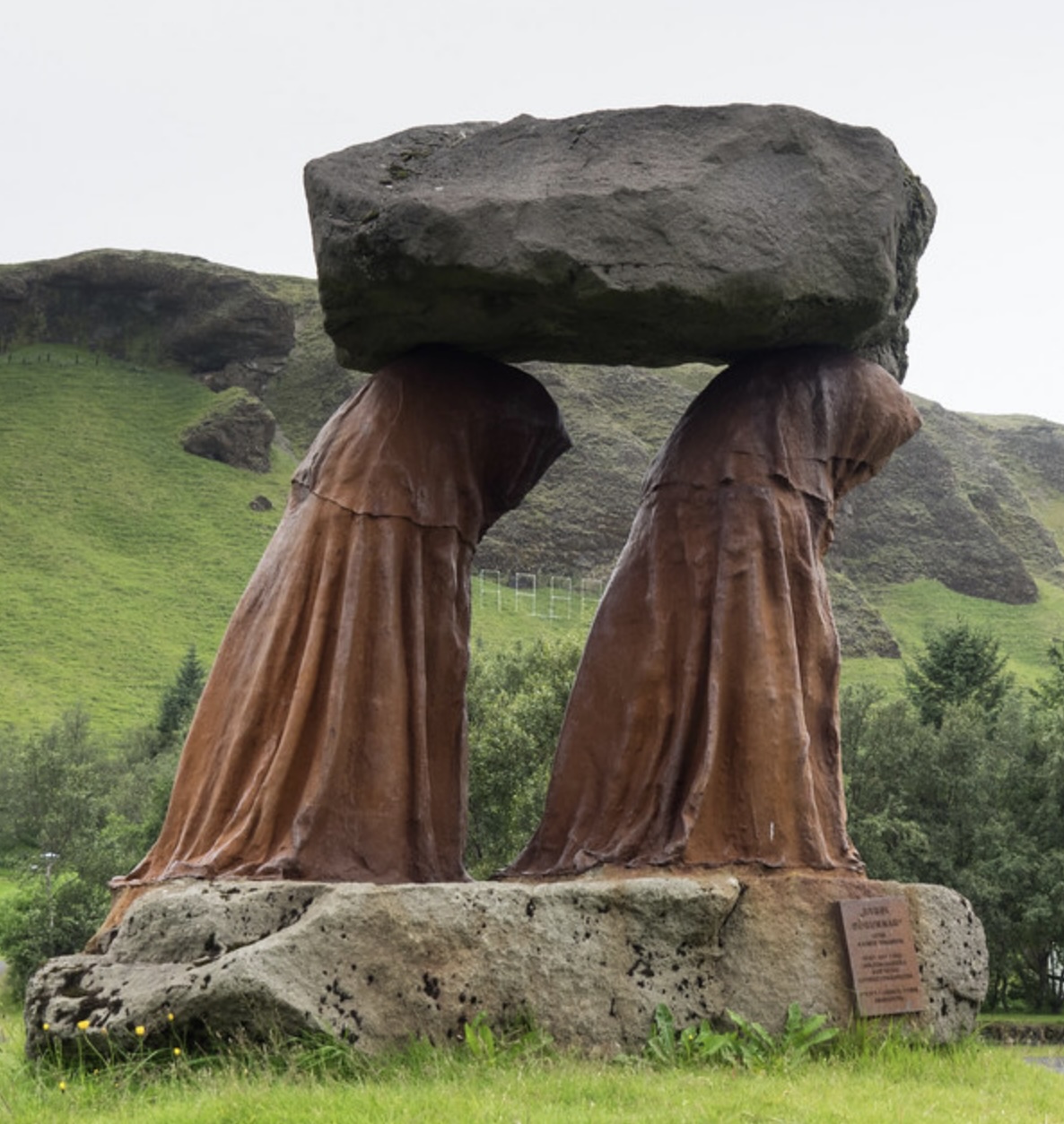
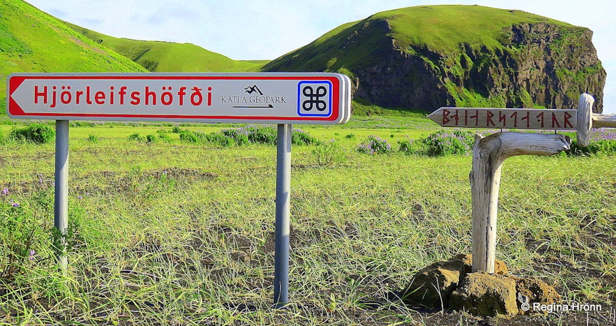
The statue ‘The burden of history’, from 1997, relates to the famous Laki fire sermon. Image from https://guidetoiceland.is/connect-with-locals/regina/klaustur
Do you remember that famous Australia TV soap where everyone in the town helped each other with their mini-crises, such as ‘who took my surf board’ and where the life guard walked around the beach in their swimmers? (I may be getting confused here with an American soap.) And again we are glued to a screen, now watching an Icelandic community under the threat of a volcano, erupting with all kinds of minor crises such as rescuing the cat, building a wall, trying to help the volcano find the right path for its lava offspring. People are surfing the red waves and watching the lava-love boat sail past. In this compulsive series, every minor drama (‘who stole my magma?’) causes a watchable eruption, while on another channel (‘The Eruptors’), the cones are being killed one by one. What better use is there of one’s time? How can one meaningfully take part in the office gossip, not having watched the latest from Grindavik?
Any volcano can create a soap drama. It may become a version of The Good Witch or become a Coven, bland versus horrific. But one beats them all with the longest running story line of any soap, albeit with rather sparse episodes. This is the real witch to watch. It is Katla.
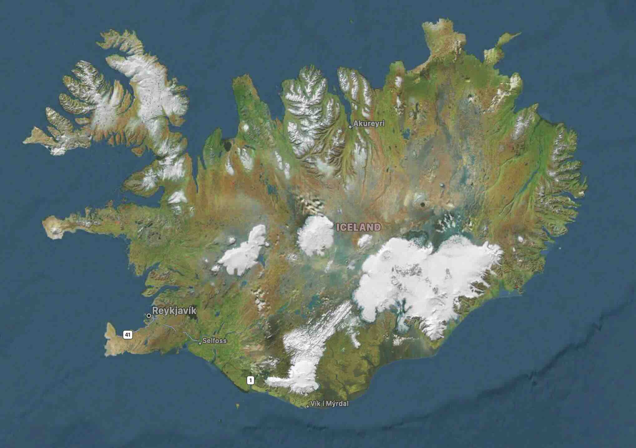
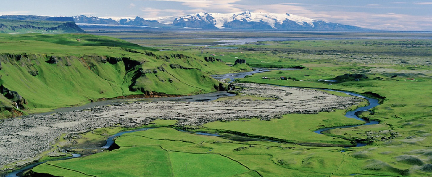
The map of Iceland shows the main mountains outlined by snow and glaciers. The largest is Vatnajokull, covering the two monsters, Bardarbunga and Grimsvotn. The southernmost glacier covers the other monster: Katla. In between lies a green land, isolated from the rest of the country. This is the land between the mountains.
From the very start of the settlement of Iceland people have been trying to make their home here. But this land is bewitched. At times it is paradise, at other times is suffers the largest disasters of all of Iceland. Much of the bewitching is done by Katla, the Witch volcano.
This is the story of the people of the land between the mountains.
The Landnámabók era: Book of Settlements
Iceland was first settled by the Vikings. Officially they arrived in 874 and had occupied the entire country by 930, bringing the settlement era to a halt. In practice these dates are uncertain. The end is very close to the major Eldgja eruption, and it is entirely possible that this eruption ended the mass migration! According to Icelandic folklore, the settlement era coincided with a time of upheaval in Norway, where for the first time a king was bringing the country under his sole authority. Authority did not sit well with many Norwegians, and this is one of the reasons tens of thousands migrated to Iceland to start a new life of freedom. People also came from the British Isles, and they may even have first come from here before the Vikings did. It is not known when Iceland was discovered, but its existence was well known before 800.

The Book of Settlements was written up around 1200. It is a list of individual settlers, where they came from, where they settled and who their offspring were, interspersed with salicious details and short stories. The stories abound with details about who murdered who and why and the feuds that followed. It would make great TV. Many settlers came to Iceland after troubles (of the lethal kind) in Norway. Others ran foul of the growing might of the Norwegian king who also had a tendency to go for the terminal route in dealing with adversaries. Such was Viking life. They did not live in towns but on farmsteads, a safe distance apart. They needed their personal space and for good reason. The people much resembled the Viking pantheon: a quarrelsome lot. Covid lockdowns and social isolation would have been a life saver for them. (Presumably there was a lot of peaceful farming as well but that did not make it into the sagas, as being too bland a soap for Viking daytime entertainment.)
The earliest settlements were coastal or located around inlets of fjords, with houses build from driftwood. The settlers began to clear the ubiquitous birchwood forests, and used the land for their animals. In some places, turf walls were being build, showing the need to enclose areas for or from animals, to separate them from those of the neighbours or from arable patches. Each farm consisted of one or more families and workers (or slaves). Dairy cattle were crucial to Viking farms. While sheep could survive the winters outside, cattle needed to be kept indoors in the winters, even in Southern Iceland. This required fodder to get the cattle through the winter, and that meant keeping patches for hay clear from animals! (One of the stories about the first Vikings to discover Iceland tells how Floki settled north of present Reykjavik, and found the bay so full of fish that he forgot about the hay-gathering and all his livestock died in the winter. He went back to Norway and spoke ill of the new land. The story places this before the start of the settlement era in 874.) A few hundred years later, farming became more marginal due to the onset of the little ice age and perhaps exhaustion of the soil. After this time, fewer cattle and more sheep were kept. The system of walls disappeared at this time.
The best land for hay, at least initially, were in places which flooded in spring. River estuaries were therefore good places for the first farms, where river valleys supported good grass growth. The farms themselves were obviously not on the flood land but were on ridges. Initially the settlements were close to the coast, in regions accessible to the sea-faring ships. After around 900, settlements appeared further in-land, still mainly along the rivers .
The Book of Settlements mentions around 400 farm sites. They were distributed over four districts or quarters (west, north, east and south, in that order), each consisting of a number of communities which were called ‘thing’. A ‘thing’ would involve farms (the Vikings did not live close together, for reasons of safety), a temple and an authority such as a lawgiver. The combination of the four Quarters with their ‘things’ became the ‘Althing’, which later was the name of Iceland’s parliament.
The map below shows the landing sites that are named in the old Icelandic histories. The southern quarter covers the south coast area below Reykjanes. The region in the southeast is part of the eastern quarter.
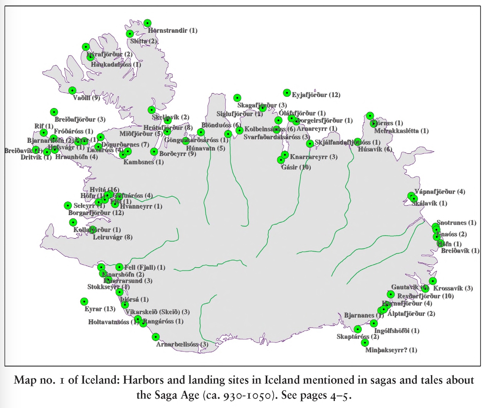
The missing south
The map shows a large gap between Vatnajokull in the east and Myrdarsjokull in the west where there were no recorded landing sites. It is as if a whole area of Iceland was left out.
It was not entirely left out. Very early in the settlement era, one of the first arrivals was Hjörleifr Hróðmarsson who settled on the coast about 10 km west of Vik, near the southernmost point of Iceland. This would have been around 874. At the time, Hjorleif’shof was on the coast and the area was forested. The forests have long gone, and there is now a deep sandy plain between it and the coast. Hjorleif only lived here for a year or so. His Irish slaves killed him. The story tells how they fled to the nearby islands, but themselves were killed there by Ingólfr Arnarson, Hjorleif’s brother. The islands were named after the Irish slaves: they became the ‘Westman Islands’ or Vestmannaeyar. Ingólfr lived in Hjorleif’shof for the following winter but afterwards moved west to the area of Reykjavik where he remained. He is considered the first settler of Reykjavik, but the settlement attempt in the south had not been a great success.
The area where they tried to settle is in fact a dangerous one. Twice it has been devastated by eruptions from Katla, the last time in 1918. Nothing remains left from this attempt, apart from a sign on the road. There is a good description of the area and it history here.
Settlements west of Vik were far more successful. A number of early settlers took sites along the Markarfljot river, west of Eyafjallajokull while others settled along the Thjorsa river. The oldest farmstead here was Eystri Skógar. Things were also well on the east side of the gap, south of Vatnajokul. After the settlement of Iceland, the fertile plains on the southwest of Öræfajökull were called Litla-Hérað and although isolated, the area was densely populated with twenty or more farms. Slightly further was Breiðamörk, also well-off, where around 900 AD, the settler Þórður Illugi built a farm. At that time the glaciers were much smaller than they were later, and between the glaciers and the coast was a prairie-like landscape with lush grass, copses of trees, and rivers. It must have seemed like heaven. The gap region in the south of Iceland must have been similar.
But in spite of this, there are only a few mentions of settlers to this gap area. The Book of Settlements records some: A man’s name was Ísólf; he came out at the end of the era of settlement and challenged Vilbald to the land or the island walk, but Vilbaldur did not want to fight and left Búland; he then owned land between Hólmsár and Kúdafljót. But Ísólfur went to Búland and owned land between Kúdafljót and Skaftár. So Vilbald ended up with land upriver (the Hólmsá is a tributary to the Kúdafljót, northeast of Katla), while Ingolf had the low land between Katla and the Skafta river. Vilbald was reported to be the first settler here: the Kúðafljót river, west of Katla, is said to be named after Vilbald’s ship which was called Kúði. Another noteworthy person is Ketill the Foolish who lived near Kirkjubæjarklaustur. He was from the Hebrides and was christian. After his death, a nearby settler, Hildir, tried to move his farm to Kirkjubær. But as he approached the boundary of Kirkjubær he suddenly died. The stories show that the area was settled and left some stories, but the names are few compared to the some 40 settlements mentioned west of Katla. Was it more sparsely settled? Less suitable to Viking farming? Or did their stories somehow not get recorded?
The region had a number of problems. There were no good harbours so ships had to be taken up the rivers. (It would be unwise to leave a ship on the coast in the winter storms that hit southern Iceland.) The rivers here, the Kúðafljót and the Skafta, were dangerous and difficult to navigate. Second, land travel towards the west was difficult because of the rivers and the terrain. So the region was very isolated. And finally, the region was exposed to volcanic activity. Most of this was true for the neighbouring regions as well, though.
Early eruptions
There were two major eruptions in the region during the settlement era, and one just before. The one before was the so-called landnám (settlement) tephra. It is an ash layer found across much of Iceland, coming from an eruption from the Vatnaöldur fissures. It has been dated to 871. The Vatnaöldur fissure is over 40 km long, and erupted some 3 km3 of tephra, mostly (but not entirely) basaltic and probably originating from Bardarbunga. (This fissure swarm produces large eruptions about every 600 years, the most recent one around 1480.) On the main land, almost all archeological excavations have found that the Viking activity began shortly after this layer was deposited, in quite a few cases immediately after. But in a few locations, including the Vestmannaeyjar islands, there is evidence for occupation during the deposition, suggesting people had already established a dwelling there. Thus, the peopling of Iceland started (slowly) just before this eruption but accelerated after the event.
The first eruption during the official settlement era was around 920, when Katla deposited black tephra as far as Reykjavik. Thus was a major eruption, ejecting 1 km3 or more and affecting this region in South Iceland in particular.
The final eruption was the Big One. In 939, at the end of the settlement era, the Eldgja fissure erupted with a fury that would would not be seen again for at least a millennium. Katla was the responsible volcano (again), but this time it pushed out 20km3 of lava though a 70-km long fissure running to the northeast. Much of the region to the west of Katla was overrun by the lava. A description of the eruption has been posted by us before. A 25% smaller eruption 800 years later (Laki) devastated Iceland, killed most life stock and reduced the population by 25% (partly through migration). But the old documents are silent about Eldgja. The eruption is not mentioned.

Extend of the Eldgja flow near the Kúdafljót river. Source
The overwhelming silence suggests that either very few people lived in the affected area, or that there were very few or no survivors and there was no one to take back to stories to the other regions of Iceland. I fear that this is the correct solution, and is the reason why there is so little mention of this entire area during the settlement era. People who settled in this apparent paradise did not survive to tell the tale. They were overcome by Katla.
Jokulhaup desettlement
After Eldgja, there was a fundamental change to the region. This went beyond the lava which had covered much of the best land. It was a change in Katla.
Katla is known not only for its eruptions, but also (and perhaps more) for Icdeland’s largest floods. The icecap regularly melts from the volcanic heat, and once the lake below is high enough to lift the ice barrier, the water suddenly empties and a flood comes down the river. There are three glacier outlets which can be used, two towards the west and one towards the east. But every since Eldgja, only the eastern one has been used. The flood deposits have become so severe that the coast of the floodplain has moved outward by 2.5 km since 1660. Before Eldgja, it would have been even more inland. This is the Mýrdalssandur plain, a desolate region destroyed by the floods and deeply covered by the sediment. The 1918 eruption was accompanied by a jokulhaup that deposited 1 km3 of sediment here. The land where Hjorleif settled became uninhabitable.
This did not happen instantly. There were jokulhaups before Eldgja. One is mentioned in the Book of Settlements, in the tale of the magician Lodmundr, occuring on the border between the western and southern Quarter. After Eldgja, Katka was quiet for perhaps 200 years. There were two eruptions in the 12th century. Around 1178, a jokulhaup is reported to have destroyed several farms in the Myrdalur region, so it appears the area had been resettled at that time – but Katla knew how to discourage this.
Something similar happened at the eastern end of the region, where a series of farms were destroyed by a major eruption of Öræfajökull in 1362. This area never recovered. It was not only Katla which haunted the region. It was caught between two volcanic, glaciated centres each of which were problematic neighbours.
Kirkjubæjarklaustur: A tale of two cloisters
The focus of the population (or perhaps the re-population) shifted to the Skafta river delta. This too had been overrun by Eldgja lava, but it recovered over the years. When history resumed, there was now a convent, called Kirkjubæjarklaustur. (Try to pronounce that one!) The name is a combination of the words church, farm and convent.
In the centuries after the settlement, Iceland became more organized and dominated by a few families. The lawlessness of the settlement period was gone. Every major farm acquired a church building: in fact there were far more churches than priests, so that having a church must have been mainly a sign of standing, being the dominant farm in the region or keeping up with the Jones. By the 12th century farms paid a tax to the main church of the region. Perhaps a quarter of churches received this tax, while the others did not. Sometimes the church owner was the only one paying the tax – to themselves! In some cases the farm owned the church, but in other cases the church had acquired the farm, either because the farmer became a priest or because the farm was donated as an endowment.
Kirkjubær held the main church of the area already by 1150. Four neighbouring farms with churches paid their tax to the farm at Kirkjubær, and were serviced by the priest at Kirkjubær.
The convent of Kirkjubær was established in 1186; the name implies that it was connected to the farmstead. It was headed by an abbess. The region had a christian heritage: the first settler here, Ketill the Foolish, was said to be a christian from the Hebrides. (It is possible this story was a later addition to the records, to claim a christian heritage.) A small part of the monastery has been excavated. A loom was found, showing that textile work was done. The excavation suggested that the monastery may have been built in European style, around a central garden. That would be different from a farmstead, and the original farm would have been somewhere nearby. But nothing remains above ground.
There was already a monastery in the region, Þykkvabæjarklaustur, established in 1168 and much larger. It was located on the edge of Myrdalssandur, just east of the Kúdafljót river. The building covered 1800m2 on the ground: the remnants were located by ground penetrating radar some ten years ago. As usual in Iceland, a large farm was associated with the monastery. There was also a school. It was a good place. Of course having a monastery and a convent somewhat close to each other (a day travel, including the traverse of the river) was an opportunity. The monks would take an outing and go to visit the nuns. In the cliff above Kirkjubæjarklaustur is a cave called Sönghellirinn – the Singing Cave. Here the nuns would sing to the monks. What followed would be a raucous party – based on rather critical comments by the bishop, perhaps not quite up to expected standards of dignity!
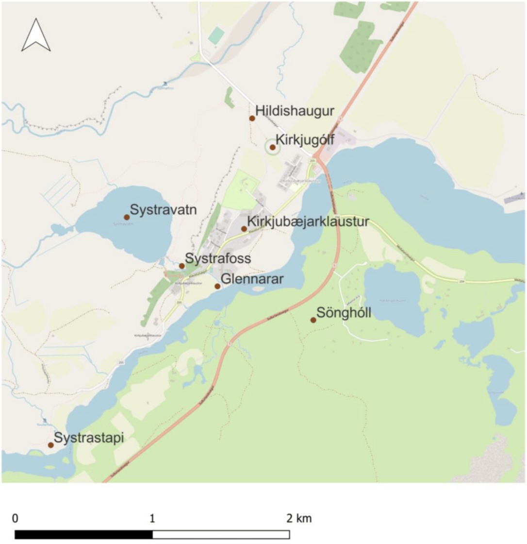
Other ancient folklore of the convent survive. The stories can only be dated because they are about the convent, which ceased to exist in 1550, so they refer to events which are older than that. One story talks about the lake above the cliff. Two nuns went here. One saw a beautiful golden comb in the lake, tried to get hold of it and drowned. The other nun rode a horse into the lake to get the comb – neither she nor the horse was ever seen again. The story explains why this lake is called Systravatn: Sisters lake. Water from the lake runs down a river through the village, where it produce a double waterfall called the Systrafoss.
The most famous story involves a rock. In its current form it probably dates from just after the reformation. Systrastapi rock is west of the village. The folklore tells about two nuns with questionable behaviour who were burned on this rock (which raises the question all capital punishment does, whether punishment is for revenge or for encouragement). One had indulged in un-nunnary behaviour (details available on request) and the other had spoken ill of the pope. The graves are on the rock. One grave remained barren, but the grave of the nun against the pope grew flowers, and she was later considered innocent. (Or rather, had been right.)
It is notable that all stories about the convent emphasize negative aspects, of nuns breaking their vows. This may indicate that the stories date from the reformation, when the catholic past was seen as something to move away from. Only the story of the nun who was burned appears in a document predating the reformation, but it only mentions one nun. The second nun may have been added to the story later, after the reformation.
The mountain, the witch and the wardrobe

https://www.south.is/en/place/thykkvabaejarklaustur The current church at Þykkvabæjarklaustur. Where the grass is green and the sky is always blue. There is a small cemetery and a few grave stones. The area around the church is called a ‘pseudo crater’, confusingly referring to a series of rootless cones.
Þykkvabæjarklaustur is forever linked to Katla. One of the early abbots employed a housekeeper of dubious temperament, called Katla. Yes, that Katla.
Katla had a pair of breeches with magical power. They allowed her to run fast as the wind (and that means something in Iceland. I can refer to the folklore surrounding the origin of VC and why we have a sheep as emblem). She would also not get tired. A local shepherd called Barði heard about this. When he lost all his sheep, he unwisely stole Katla’s breeches to be able to quickly relocate them and get them back.
Katla learned about the theft and employed her temper in old-fashioned Iceland Viking way. She drowned him in a vat of whey and left him there. It probably added taste to the whey but somehow people did not notice. However, eventually the body would be found. In desperation, Katla fled and threw herself into a wide crack in the ice of Mýrdalsjökull glacier. She turned into a witch living underneath the ice. She caused a terrible flood which almost destroyed the Þykkvabær monastery itself. And still she tries.
This is the story that equates Katla with a witch. And not a Good Witch. This one has a temper.
Laki
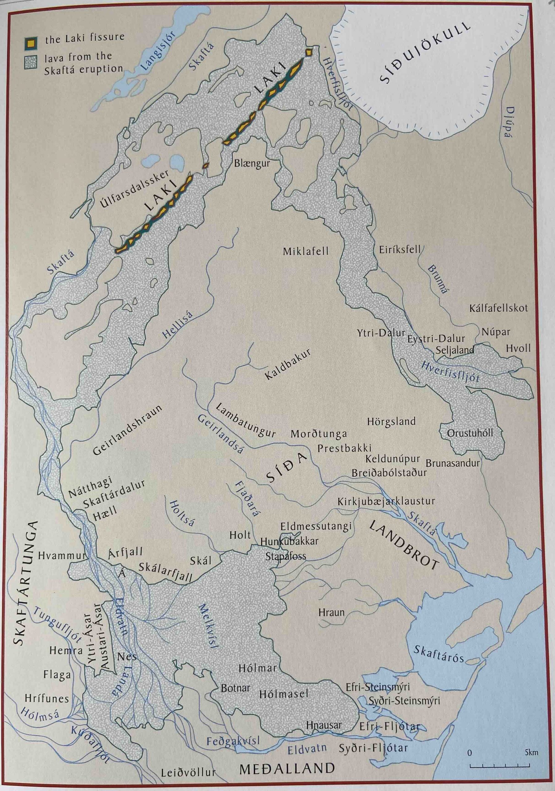
The Laki lava flow. From Fires of the Earth, University of Iceland Press, 1998
The convent and monastery were closed in the reformation of 1550. But life continued, punctuated by eruptions from Katla. The next big problem though came from the other mountains, from Grimsvotn.
By the 18th century, things were well in the area of Kirkjubæjarklaustur. The land is described as having ‘high fertility and great bounty’ so that ‘men hardly knew how many sheep they owned’. But on the morning of Whitsun, 8 June 1783, this ended in a spectacular fashion. ‘In clear and calm weather, a black haze of sand appeared to the north of the mountains.’ It spread: ‘It caused darkness indoors..that night strong earthquakes and tremors occurred.’ The Skafta river dried up entirely. Four days later lava came down the river valley and spread out over the older Eldgja lava. The Laki eruption had begun; by the time it had ended, the region was again largely depopulated although not abandoned.
Four farmsteads were quickly overrun. The church at Holms also went up in flames. The priest had locked the church, so that people who came to rescue the church ornaments before the lava arrived, could not get in. Security can be so counterproductive.
One Laki date especially stands out in Iceland’s history: 20 July 1783. It is still celebrated annually. Lava was still coming down the Skaftá river valley and was threatening the farmland of the parish of Kirkjubæjarklaustur. These was the dark days of summer. Lava was now approaching the church and it seemed certain to be overrun that day.
We know more about the Laki eruption than about any other of similar date. There is one reason for this: Jón Steingrimsson, the priest of the parish. He was well educated and had a keen scientific interest. Jón had experienced the Katla eruption of 1755, one of the largest in historical times when tephra was a meter thick in places and ash fell in Shetland, and he had become interested in volcanoes. (I would like to imagine he would have been a keen VC reader.) But on this day, he had a congregation under threat of imminent extinction. Jón decided to hold the Sunday mass anyway, in spite of the rapidly approaching lava and knowing the church would likely not survive the day. It was hazy and dark, and there was lightning over the lava. The story tells how the ground trembled, and the bells echoed and wailed with the cracks of thunder, while Jón gave his sermon about God’s will. His sermon became famous (albeit unrecorded). It is now known as the Eldmessa, the fire sermon, and Jón became known as the fire priest. Afterwards, when the congregation exited the church and rushed to see the approaching the lava front, they found that it had stalled. The church and the parish were saved. The lava did not get further: the end point is still known as Eldmessutangi: the fire-sermon point. It is close to Systrastapi rock.
Eldmessutangi. Source: https://nordichouse.is/vidburdur/mats-wibe-lund-ljosmyndasyning/
Jón was attributed with a miracle. He agreed that God had stopped the lava but thought that the miracle had been in the timing. Being an excellent observer, he looked for the ‘how’ and concluded that God had made use of the smaller rivers that were still flowing when the Skafta itself had dried up, and had cooled and solidified the lava.
The area survived the lava but was still devastated by the impact of the Laki eruption. Many people died or left. Jón also went through hard times, and saw his wife die. The church survived the eruption but not time itself. It is no longer there. A new chapel was build in the 1970’s. The old cemetery contains a few gravestones, including that of Jón and his wife Þórunn.
There is a wonderful description of the area and its history https://guidetoiceland.is/connect-with-locals/regina/klaustur
Past to present
Of all the regions of Iceland, the south coast between Katla and the mountains of Vatnajokull shows the clearest impact of the eruptions. From being involved with the very start of the Settlement, it became a region where people moved through but did not stay. It was a fragile paradise to begin with, of river plains and forests. The fragility was because it was build on volcanic sand. Eldgja must have been a massive setback, so bad that no real records survive. It changed everything, with lava covering the land with the best soil, as well as the forest and the rivers. After that, the jokulhaups came in the west and the eruption of Öræfajökull in the east, leaving only the central region of the Skafta river as the habitable heart. Then the Laki eruption hit the heart. Every time people had to start anew. They managed – this is Iceland, after all, and people don’t just live off the land: they also have the sea.
What does it mean for the future? The largest eruptions in Iceland have come from Lurking’s Dead Zone: the fissures between the mountains which can be fed from either side. These eruptions occur many centuries apart, but the risk is always there. And now the glaciers are melting under the increasing heat and this makes the jokulhaups less predictable. In fact it makes the eruptions less predictable as well as melt water plays a role in them.
We watch the developing story of Grindavik which after 800 years of security finds itself threatened by a reawakening of the volcanic system. And we think of Katla which has been asleep now for over a century. Katla does not do patterns: we can’t predict whether the next eruption will be small or large. But one day a prince will come, kiss the wrong princess and wake the Witch. Ash will cover the land. There will be jokulhaups, and they might take the old route on the other side of the mountain, into a land that has not seen them for a millennium.
The story of the land of the two mountains is not ended. There will be more chapters.
Albert, May 2024

Katla’s historical eruptions
Here are the known notable eruptions of Katla, copied from https://perlan.is/articles/katla-volcano-eruption
- 920: The first eruption after the settlement. Medium sized. Undocumented eruption but a tephra layer exists witnessing the eruption
- 939: An eruption in Katla and a hazardous glacial flood accompanying the tremendous Eldgjá eruption.
- 12th century: A small sparsely documented eruption
- 1179: A small eruption but the glacial flood ruined some farms
- 1245: A small eruption
- 1262: An eruption leads to a large jökulhlaup (glacial flood) and tephra fall
- 1357: Medium sized eruption, heavy tephra fall. Glacial flood (jökulhlaup) destructed many farms
- 1416: This eruption and subsequent jökulhlaup cause severe damage
- 1440: A small eruption and sparsely documented, no damage
- 15th century: Small undocumented eruption, a thin tephra layer has revealed its existence
- 1500: A large undocumented eruption. Heavy tephra fall all over south and southwest Iceland along with Reykjavík.
- 1580: A small eruption, no damage
- 1612: Small eruption and jökulhlaup occurs
- 1625: A powerful eruption. Tephra fall experienced in Faroe Island and in Trondheim in Norway. This eruption lead to significant flooding
- 1660: Medium sized eruption along with heavy tephra fall and flooding. The farm and church in Höfðabrekka destroyed
- 1721: This eruption caused a large jökulhlaup that lead to significant property damage and changes in local geography
- 1755: A powerful eruption, the largest one in Katla in historical times. Hazardous glacial flood and heavy tephra fall, people killed by lightnings from the volcanic cloud.
- 1823: A small eruption, insignificant damage
- 1860: A small eruption, some damage in Mýrdalssandur
- 1918: The most recent large eruption with heavy tephra fall and glacial flood. The flood deposits moved out the coastline by many hundred meters
- 1955, 1999, 2011: minor subglacial eruptions


Hi Albert and everybody else.
Thank you for another great article and sharing your insightful information – as always.
I have another issue, which I have stumbled over a few weeks ago and would I like to reqzuest for some well-founded opinions:
I recently read an article about a `rapid true polar wander` during the last ice age, which means that changes in mass distribution on earth during the glaciation period could have changed the axis of rotation on earth with the north pole slipping towards the North American continent with the result of increasing glaciation of northern Europe and north America, meanwhile eastern Siberia became a steppe, green Sahara … a.s.o…
Thinking about this hypothesis, much is making sense to me about what could have happened during the past 10k to 100k years in regards of the regional climate changes, and considering that the spin axis of a heavy gyro (rotating earth) is quite complex, I wonder, if there is any evidence of this theory to be true, or if there is absolute evidence, that this is nonsense at all.
I am asking myself, if there is only no real evidence, that some kind of wobbling of earth rotation axis (polar wander) could have appeared during the past tenthousands of years, or if there is definite evidence, that this never happened. Maybe someone can give a usefull hint. Thank you and kind regards.
Thanks for the kind words. True polar wander is a very slow process. It requires the movement of the mantle and crust, each with their own viscosity. It would show up as an apparent change in the magnetic pole (which is fixed by the core). We know that that has changed by no more than 1000 km in 100 million years, which is less than 1 km since the start of the ice ages. The ice ages are therefore far too recent to have had an effect. There has been some discussion about faster true polar wander during the break-up of supercontinents 800 million years ago but this is very controversial.
Is this not the same idea as axial tilt precession but with a different core factor? Egypt had Thuban/Alpha Daconis as their pole star when tbe Giza Pyramids were designed and built, which was half way back in time to the Younger Dryas and worst of the megafauna extinctions. If the actual pole had moved I dont think that alignmebt would be so easily traceable.
I have also seen stuff about the moon making it very difficult for the Earths axis of rotation to change, its possibly a gyroscopic effet or at least appears to be. Jupiter is similar because of shear mass it cant really precess or be affected by anything, and is only a few degrees out of the orbital plain. But the other planets have evidece of changing a lot more expecially Uranus obviously, and Venus being the most extreme if its retrograde spin is a result of it flipping upsidedown.
No, that is a very different thing. The precession is the whole earth changing its orientation, like a spinning toll. Everything on Earth stays as it was, just with a different star overhead. True polar wander is whether the rotation axis of the earth changes with respect to its surface. A place on Earth would change its latitude – if you were on the pole, you’d no longer be and the pole would have shifted. It can happen, and is for instance known from Mars, but it is a very slow and hard process. On Mars the pole moved by about 15 degrees, probably when the Tharsis bulge formed 4 billion years ago.
Between a rock and a hard place. In the west – the wicked witch. Katla bides her time deep beneath the glacier. In the east – Grímur, the troll who killed his father-in-law, sits by his cursed lakes. Between the two lies an otherworldly place. The dead zone. It’s beauty makes it seem enchanted, but make no mistake – the spell that has been cast upon it is a curse.
Nice article Albert. Always a joy to read.
not finished with the article yet, but I am most fascinated by the story about the origin of the name of the Vestmannaeyjar!
Kilauea has gone seismically quiet but the inflation is still rapid at the summit.
-8 to +12 microradians on UWEV, 22 total, this station happens to coincidentally display 1 microradian to an equivalent of about 1 million m3 of magma (others do not), so in the past month the supply rate is 22 million m3 in 31 days, or about 650,000 m3/day. This is about twice the Pu’u O’o rate and also faster than the inflating sill at Svartsengi.
At the same time SDH has gone up from -50 to +70 microradians, so 120 total. So it might be plausible to put a rate of 5 microradians per million m3 at SDH vs ~1 for UWEV. Im not really sure if this is directly comparable though, as the green line at SDH is not measuring tilting from the direction of Halemaumau but the south caldera and upper SWRZ instead. Im also unsure if the above supply rate would actually be an underestimate and not include the SDH uplift.
Either way Kilauea seems primed to do something very soon even if quiet at this moment. A bit of a race between it and Svartsengi right now. We know what Svartsengi will look like when it goes next but an eruption in the 2018 caldera could well be of a similar or even greater magnitude.
It is an impressive change. The conversion from tilt to magma volume is a dangerous one, though. It depends very much on depth and location (a mogi model), and also depends on gas content: gas coming out of the liquid can cause inflation without any change in magma volume. I wouldn’t want to put numbers on. INSAR data would be better for that, but can also be seeing a change in magma depth rather than volume.
Thats why I said about 20 million m3 not exactly 22 million. The average rate before 2018 during the Pu’u O’o era was 0.15 km3/year erupted, although there was inflation alongside this along all of the ERZ from 2011-2018 so the totalsupply was higher. The supply from 2005-2009 was apparently as much as 0.4 km3/year at one point, more than all of Iceland combined, although the eruption rate at Pu’u O’o was not proportionally stronger in response.
There is an INSAR, posted fortnightly at
http://www.mounts-project.com/volcano/33201010
The strongest inflation is actually not under either rift connector, the magma system of Kilauea is huge and the existing caldera only covers a part of it. Possibly the Koae faults are not only a rifting graben structure but could be partly from summit subsidence. Its also possible the satellite angle artificially moves the uplift center though too but I dont know how to pick that out.
Halema’uma’u is rebounding from a DI event and because supply was high during the DI, its floor slopes upwards, it’s returning to a higher level. The DI event interrupted magma flow into the rifts, so earthquakes have stopped, and still not resumed. A Halema’uma’u eruption could be relatively sudden, with little or no long-term seismic prelude.
It’s hard to know how unusual this is since GPS monitoring only started 20 years ago, and for most of the time Pu’u’o’o was ongoing, and also because past tiltmeter data other than Halema’uma’u is hard to find. Also, because Kilauea has some 5 different long-term areas of sill-like inflation plus the deep rift. But clearly activity has increased a lot compared to late 2020 and early 2021, when inflation took place in areas similar to now but change rates were minimal in comparison
The last INSAR,
http://www.mounts-project.com/static/data_mounts/kilauea10/2024/kilauea10_20240421T161643_20240503T161643_VV_ifg_thumb.png
I think every full colour transition is a total of (2.8×2) cm, so if I am correct the highest uplift is about 24 cm. There has been about that uplift at AHUP in the past month. Although the INSAR is only 21/4-7/5 so 2.8 cm could be the whole range and the picture shows about 12 cm uplift instead. Either that or the peak uplift is very localized and none of the stations are close enough
Seems like something happened here too, although it might not be volcanic it does show on both rift connectors so I would presume magma movement. Still no new intrusion but must be close now. Problem is Kilauea in this state makes Hekla look predictable, anything is an option really the only thing to go off of is statistics.
The Big Volcanoes of Iceland often deserve a pleasant story like this! Katla and Hekla are two of Iceland’s most tricky volcanic personalities. Very different to the friendly volcano Etna. Katla is one of the volcanoes which are relatively close to Icelandic civilization, while Krafla, Askja and Vatnajökull are more distant.
Katla can – like Hekla – do very sudden eruptions. The sudden Jökulhlaups due to subglacial minor eruptions can occur even more unpredictable. Katla mixes Phreatic explosive activity with partially evolved explosive magma. “The dominant magma type is trans-alkali basalt, but within the central volcano silicic magma, dacite to rhyolite is occasionally erupted.” https://icelandicvolcanos.is/?volcano=KAT
I mean, to be honest Etna is probably a lot more dangerous than Katla or Hekla can ever be. It erupts often which keeps activity minor, but there are 3 Icelands living on the side of it…
If Etna had an eruption like in 2001, fed from an eccentric dike out of the deep source (basically a new monogenetic cone) but it was far down the slope, that would be a disaster. Its likely to be seen beforehand but the damage would be apocalyptic, probably far more than even if all of Grindavik was wiped out completely. Its the once a millennium events at volcanoes we think are harmless that are probably the biggest hazards in the entire field. Imagine Kilauea in 2018 went full force immediately and 1000+ people lost their lives that night… The biggest volcanic disasters of the 20th century, Pelee and Ruiz, were pretty harmless eruptions that went to tbe wrong place at the wrong time, the risk underestimated and or not taken seriously.
Naples of course being one of those promising places for the next Pelee-type scenario. Like a mere VEI 4 near the eastern edge of the caldera, say Rione Traiano. Ruang only send out pyroclastic flows a few kms. But 1.2 million people live within 3 km of Rione Trianno… Even if an official evacuation is done in time, there will be thousands of fools who refuse to budge.
One year ago Fagradalsfjall showed clear inflation:
“Published 4. July 2023
Since the beginning of April, GPS and InSAR have shown a renewed inflation signal originating from beneath the Fagradalsfjall region. The largest signal observed is around ~ 1 cm/month.”
https://en.vedur.is/about-imo/news/earthquake-activity-in-fagradalsfjall-area
2024 Keilir station doesn’t show any uplift. Since December it has contrary to 2023 deflated. Is the station FAFC still working? I haven’t found it on the GPS website, but it was the station they reported about in July 2023.
“InSAR analysis from the end of the August 2022 to the end of May 2023 reveals three subsiding areas: at Reykjanestá (SW Reykjanes peninsula), Svartsengi, and the northern side of the 2022 Fagradalsfjall lava field”
Before the last Fagradalsfjall eruption Svartsengi was subsiding. Now we see the opposite movement. Svartsengi inflates and Keilir deflates. It looks like a negative correlation, that would indicate that Fagradalsfjall stays dormant 2024 or is going to wait until the First Sundhnukur Series is over.
FAFC was removed and placed elsewhere, since it was threatened by the lava from the eruption next to Litli-Hrútur.
The Reykjanes Peninsula is currently going through a rifting sequence. As the plates shift, the ground is pushed and pulled. Magma is coming up from below, accumulating in one place, then moving on to the next. The ground deformation is a complex combination of all these different processes. Far from all the observed deformations are caused by magma.
In the run-up to the first Fagradalsfjall eruption, there was a sequence of strong quakes that shifted a stretch of the main Reykjanes fault, centered around Fagradalsfjall. It shows up really well in InSAR data – a long dividing line with land north of the line moving to the NW and land south of the line moving to the SE.
If you look at the period between the last Fagradalsfjall eruption and the first Sundhnúkar eruption, there was ongoing deep inflation under Fagradalsfjall. In October, a sequence of strong tectonic quakes caused the next section of the main Reykjanes fault to shift. Again, this shows up well in the InSAR data. It culminated with the formation of the large dyke in November. Unsurprisingly, the current series of eruptions are happening near the center of the part of the fault that shifted in those tectonic quakes. This indicates that the rifting generates space for dykes to fill, then eruptions keep happening until the space has been used up.
What will happen next? I don’t think the Sundhnúkar eruptions are done quite yet, but eventually there will be no more space left by the rifting to fill and the rifting will move on to the next stretch of the fault. It could go in the direction of Eldvörp, or towards Krysuvík. Whatever way it decides to go, there will be strong earthquakes first to shift another stretch of the Reykjanes fault. Which one will it be? Krysuvik has seen a lot of earthquake activity already. It has been put under a lot of stress and eventually it will give. Eldvörp on the other hand is closer to a part of the fault that has already rifted. The sill at Svartsengi reaches in that direction, so magma is already available. Just a little more rifting needed and it could go.
Yes, before the first initial Fagradalsfjall eruption there were strong earthquakes. The extension of the plate boundary created space for magma rise. The two previous Fagradalsfjall eruptions (II and III) had no severe earthquake. Maybe the neighbouring systems (Krysuvik, Brenniseinsfjöll, Reykanes) need more rifting and severe quakes to occur, before an eruption happens. But they have time for centuries. We don’t know whether they’re already ready for a eruption series during our livetimes.
If Fagradalsfjall IV happens after a dormant period of 11 months, the eruption will be in June. If the ongoing eruptions of Sundhnukur change this, Fagradalsfall may have to wait more. Has Fagradalsfjall 2021 begun a longterm Fires Cycle, while Sundhnukur does a relative shortterm cycle? During the last Reykjanes Fires (Middle Ages) the first Krysuvik eruptions were around 900 (Afastapahraun), and there were late eruptions 1151-1188.
Krysuvik did erupt in about 900 but that eruption was at Hrutafellshraun, which is in the same valley that the eruptions in 1151 happened. Afstaphraun was part of the cycle before that, so is a similar age to the old Sundhnjukshraun. The eruptions were very intense, lava reached the ocean on both sides of Reykjanes and flowed around 13 km on flat ground to reach the north coast. It also is pretty clear that, like we see now at Sundhnjukur, there were at least a few eruptions along the same fissure, which was as much as 12 km long.
This area did erupt in 1188 making the lava of Mavahliðahraun, but that was pretty small, similar to the eruption at Litli Hrutur rather than a curtain of fire.
Its not unlikely an eruption happens in this area in the current cycle, but so far the areas of strongest tectonic activity have been strong indicators of where future rifts will appear, something I have only found in hindsight. The 2021 intrusion moved the whole Reykjanes fault, and obviously was strongest along the dike itself. But the second major focus of quake activity, and recurring in all subsequent Fagradalsfjall intrusions, was exactly along the rift that opened in November last year.
By this logic, the areas most likely to rift after Sundhnjukur are at Reykjanes Stampar and Eldey, further offshore of Eldey, and underneath Kleifarvatn. Less likely is at Eldvorp, East Trolladyngja, Blafjoll and Hengill. The wildcard is something in the Þingvellir rift, although that is probably not part of the same tectonics.
Its also a question of how connected all of this is to the SISZ, and to Hekla, the last cycle apparently did matter as Hekla got 10x more active and went from rhyolite to andesite after 1104 while rifting in its fissure swarm became less important.
Krysuvik during the Middle Ages showed that this area can do eruptions over centuries. Fagradalsfjall can be seen as a subsystem of Krysuvik that is able to do a long cycle over centuries, while other volcanic systems on the peninsula do their eruptive cycle over a shorter period of f.e. 30 years.
In the background of that photo of he statue ‘The burden of history’, up on the hillside is the same 7 segment digit display seen in front of the web cam on Mt Þorbjörn. Are these common across Iceland?
GRV drum plot has been showing lots of small shocks since about 9pm last night. There are some longer signals since about 04h30.
The tremor is also back to peaks about 5,000 and the line is a bit thicker, even though there are still regular lulls in the tremor dropping back to about 2,000.
Overnight seems less likely for berm building. Do we think this could be signals that an eruption is warming up or is is a weather / human activity noise?
Since it only shows up on grv it has to be a local signal. There’s a new signal every 15s. Could be a machine pushing dirt. I think they are working day and night to enhance the berms. The last eruption placed lava all the way up to the berm, making it easy for lava to breach it during the initial high output of the next eruption. Since the next eruption is expected to start any time now, it’s urgent to get reinforcements in place.
The Borgarfjall suður view that can be seen here:
https://www.almannavarnir.is/eldgos/myndavelar/borgarfjall-sudur-sudaustur/
shows the ongoing construction quite nicely. Particularly during the (brief) hours of darkness you can see the construction vehicles with their headlights.
Quake activity is picking up now. Might be a good time to start watching the webcams.
No real swarm yet, so maybe I reacted a bit too soon.
The magnitude is a little higher than it has been though. Most of the activity is towards the southern end too.
I also noticed how much of the activity was towards the southern end, however I noticed the same thin with the last eruption. Lots of activity south and west of the expected area then suddenly erupting again in the area that the IMO pinpointed. So I am inclined to look to the area of the previous dyke and eruptions for any future eruptions.
They are actually a bit offset from the dyke. I suspect the active part of the dyke is further north and these are triggered quakes due to increasing tension in the crust.
I agree Tomas, and it certainly was the same scenario last time.
It could also be movement in the subsiding areas. From pictures published by IMO, there seems be countless faults in that area.
What is this on the far left of the Hagafell webcam? Looks like a smoke column rising up. I’d say Svartsengi except it looks very dark? Or is it an incoming fog bank? Am I imagining things? It’s gotten less distinct but bigger while writing and checking other webcams for something. I feel where it’s coming from might be just close to the sea if I’ve my orientation is right
https://www.livefromiceland.is/webcams/grindavik
I’d say low cloud except the shape is a “v” narrow at the bottom and wider at the top as it it’s rising rather than coming down or travelling. No signals anywhere else though. As mentioned above the drum plots must be the new berm.
Well it’s gone now and it’s dark. It must have been some weird cloud
KOSM GPS on Kilaueas SWRZ
The volcano is quiet and the center of activity appeared to be on the ERZ, but this station shows that magma is still most definitely intruding the SWRZ. About 15 cm of both uplift and westward movement since the intrusion in February, all apparently without inducing a seismic crisis like earlier in the year. To me it looks like the February intrusion might have opened enough space that magma is just flowing into the area quietly still, and that section of the flank has been mobilized.
CNPK GPS on the upper SWRZ at Cone Peak. The uplift here is extraordinary, in under a year there has been over 40 cm of uplift and only 20 more to reach the 2018 level. If the current rate is maintained this could happen as early as a few months from now. The ERZ still has a long way to go, and the caldera stations are variable, but the SWRZ magma system is very nearly fully recovered. The present day CNPK level of uplift is to the same level as it was in 2015 before the runup to the 2018 eruption.
It remains to be seen what the newly active ERZ connector will do but it seems very likely the SWRZ will see much activity. KOSM is at the same elevation as the floor of Halemaumau.
CNPK is a good distance away from the centers of inflation, and there was also an elastic rebound from the dike intrusion in February that uplifted the station by as much as it fell from deflation of the south of the caldera region. OUTL is best to judge the pressure state of the SWRZ since it’s over the inflation center that activates during the SWRZ earthquake crises (during the early October uplift episode that was related to SWRZ swarms, OUTL uplifted over 10 cm but only shifted 2 cm sideways, mostly vertical, while in CNPK the displacement was mostly horizontal). For distal parts of the SWRZ, KOSM might be the best indicator.
OUTL has barely just recovered deflation from the February SWRZ dike intrusion, so I don’t think the rift is significantly more pressurized than it was back then.
For the UERZ, I think PUHR is the best indicator, unfortunately the station has data for only very recently. AHUP is a bit between the UERZ and SWRZ typical sources of inflation, so might be a good indicator for both.
SWRZ appears to be out of the game for now. But the intrusion remains a possible reservoir/base for future eruptions. We don’t know how many intrusions preceded the eruptions around 1790-1823 of SWRZ (Kamakaiʻa, Kealaʻalea and Keaīwa lava flows) . But do we know whether the 1790-1823 SWRZ magma itself was fresh or stored magma?
2018 Leilani Estates eruption showed, how reservoirs of past intrusions can erupt after many years. The first magma/lava that came up, was old and relatively viscous basalt of old intrusions. Some SWRZ eruptions had predominantly Strombolian behaviour, a bit like Paricitun.
Kamakaia Hills was stored magma, first basaltic andesite then basalt with a low MgO content. Similar to the 2018 stuff that first erupted although it still formed pahoehoe flows so was maybe hotter. Black Cone further southwest was probably part of the Kamakaia eruptions too.
Kealaalea flows and 1823 Keaiwa flow were lava from within the caldera that intruded down the SWRZ through the shallow surface cracks and leaked out. So it is primitive summit magma.
The lava erupted in 1974 was very magnesian and hot, almost a complete opposite to the Kamakaia eruptions. So being realistic pretty much all the spectrum of magma from borderline komatiite all the way to andesite can erupt on both rift zones. Because of the largesummit magma system now I would expect a fluid lava with 6-7% MgO to erupt but maybe with some evolved stuff at the start or alongside it.
Can we estimate when the magma was stored below Kamakaia Hills? If we know, how much time magma needs to evolve to basaltic andesite, we can calculate approximately when the intrusion of this magma happened.
Probably not really because magma flow to the area likely happens without erupting sometimes. Its not just magma from the last eruption nearby but there is probably a semi-permanent storage area, same as far down the ERZ.
Yes, there is perpetual magma storage below the Kamakaia Hills. When the SWRZ inflates, although the center is close to the summit, a distinctive inflation branch extends as far as the Kamakaia Hills. The area near the Kamakaia Hills deflated for a long time after the 2018 eruption, when the rest of the volcano had already started to re-inflate.
I would guess that is why the SWRZ seems to be so active, the summit has refilled enough so now it is easier to have magma flow that way, and maybe soon into the ERZ too. I guess the question is if the SWRZ can erupt before a clear path into the middle ERZ from the summit forms again. It did after 1790, taking over 30 years until 1823 to reach the ERZ again. But that collapse was a lot larger than in 2018 and in fact Kilauea now is on track to recover completely by 2030 so the similarity might be superficial.
Still, Kamakaia is at the same elevation as the ERZ where Pu’u O’o formed, except now Pu’u O’o is there and with it a huge new lava shield. So to reach a point on the ERZ lower than the Kamakaia hills needs magma to get past Pu’u O’o easily, and I dont know is that is likely.
There may well be intrusions and small eruptions along the connectors of both rift zones but these wont relieve pressure at that elevation so the eventual outcome is either an eruption down in the middle SWRZ area or magma starts flowing into the middle ERZ. The latter option will probably result in another satellitic shield eruption, especially if it does actually get east of Pu’u O’o. The summit need not fill any more to do this although there will probably still be many more eruptions in Halemaumau in coming years.
Thank you, Albert, for another entertaining article!
My estimation that an eruption of Sundhnukur would occur until yesterday proved wrong. Maybe the volcano now needs more time to “brood” the next eruption. The first three episodic eruptions were likely part of the introductary stage of the Fires. With the 4th episode (“A New Hope” in Star Wars) the main Fires might have begun. If we ignore the episodes, the general longterm trend of uplift at Sundhnukur area is clearly positive since November. The volcano is on a high level of general activity. This means, if the trend of the recent eruption continues, relative big and long (weeks) lasting eruptions. The relative big eruptions both in March (and probably next in May) have needed more preparation time than the smaller introductary eruptions.
Today IMO writes in English:
“Lesson learned from the Krafla Fires was that as the number of dyke propagations increases, more pressure is needed to trigger them. Therefore, it must be considered likely that magma will once again flow from the Svartsengi magma reservoir to the Sundhnúkur crater row, but there is an uncertainty as to when sufficient pressure will be reached to trigger a new dyke propagation and/or eruption.”
So it’s not accidental that the dormant period increases.
How sudden can Katla do the Plinian eruptions? Do we need more deformation/seismicity/… before Katla does a major eruption? Can we exclude the Hekla scenario of an eruption within a few ours?
Katla is a caldera so probably an eruption will have short immediate warning of a few hours but there will be a pretty obvious long term warning that an eruption is likely. Things like either long term i flation or the magma chamber is seismically active, indicating supply of magma is basically 0 and the pressure is rising fast to breaking point.
Kilauea shows all of this very well but probably all of the same signs occur in Icelandic calderas too. Hekla probably does all of this too but because its magma system is over 10 km deep it isnt easily detected.
The bit that us kind of hard is the intermediate stage of warning. The volcano being in a state of high pressure makes it pretty clear something will happen but as we saw at Kilauea unless a dike actually breaks out it can all calm down. When a dike does start though it is very obvious but could also be extremely fast and so the warning is brief. Kilauea is monitored by as many instruments as the whole of Iceland (well, maybe not quite) and still managed to take the USGS and everyone else completely by surprise in 2020. So if Katla starts showing signs of being active it could very well just suddenly go full force even if recently that hasnt happened. Same also for Grimsvotn, although probably not so big. Hekla really is a bit unknown now it broke its cycle, but I am a bit skeptical it is truely aseismic after its more typical dormancies, no seismometers there in 1947…
Albert mentions the risk for sudden jökulhlaups. Were the recent minor events 1999 and 9 July 2011 examples for this? In the pre-science centuries they wouldn’t have noticed much of the warning signs.
“Microseismicity preceded and accompanied a jökulhlaup (a glacier-outburst flood) on 9 July 2011, as reported by the Iceland Met Office (IMO).”
The run-up towards a major Plinian eruption would likely be different. Would Katla need more deformation before such an eruption or is she already capable of this now?
To be honest I think the fact Katla has possibly had at least 3 and maybe more minor eruptions that couldnt break the ice, probably means the volcano isnt really primed to do a large intense eruption. 1918 was not the biggest but it was still among the larger historical eruptions. But more importantly maybe is that Hekla has been particularly active after 1918. Its eruption in 1947 was large but expected, and around 1 km3 of magma mostly lava but still a VEI 4. However the combined volumes of the 1970-2000 eruptions is around 1 km3 too, which is 2 km3 in the span of about 50 years, maybe the most erupted in that timescale in the historical record. Despite the claim Hekla is dead silent until it isnt this is also not really true too, its fissure swarm has seen inflation and quakes are not uncommon in the area, all signs of a highly active system just not one that can erupt right now. Katla has had a lot of deep quakes in recent years but nothing much shallow, suggesting that its magma supply is low but the generation rate at the source is high, it could be accumulating at depth or is going towards either Hekla or Torfajokull, which is also inflating…
Basically, Katla is probably quiet because Hekla and Torfajokull are dominant of the source. Hekla will probably do a big eruption in the next 20 years either directly or as a fissure along the fissure swarm. Torfajokull might well induce the next Veidivotn rift, I dont think it is as passive in those events as often believed and erupts on its own alongside Bardarbunga.
I wouldn’t ignore Katla just because it had three minor eruption in the past century.. And there is no pattern to it: it can do a major eruption soon after a minor one, or a massive eruption soon after a major one (as in the case of Eldgja). If Katla does this with its own eruptions, I doubt that it pays much notice to a distant volcano like Hekla.
And it does not give much warning: for the large 1918 eruption, the first precursor event (ripples in a river) were seen 3.5 hours before the eruption began, or at least broke through the ice.
The main term that comes to mind is ‘unpredictability’.
The most recent Jökulhlaup of Katla was linked to the eruption of Eyjafjallajökull 2011. 2010 some scientists predicted that Katla would blow up after Eyjafjallajökull as it/she did 1821. Katla’s neighbours had luck that there only was the minor subglacial eruption 2011 and not the Plinian version.
Can we compare the eruption 1918 with Grimsvötn’s major tephra eruptions (f.e. 2011)? Both are eruptions in a glacier that break through the water/ice level and do high Plinian eruptions. Both volcanoes do jökulhlaups, but Katla a bit larger than Grimsvötn. I have the impression that Katla can do a jökulhlaup immediatly with the start of a Plinian eruption, while Grimsvötn usually does the jökulhlaup after the eruption.
Katla 1918 was a VEI5, Grimsvötn 2011 VEI4. One Plinian eruption of Katla has the force of several Grimsvötn eruptions (2011 VEI4 + some normal VEI3 events) combined.
1918 had no monitoring, most volcanoes would be very sudden to erupt without our modern instruments. So I dont really think that is a fair comparison really. Kilauea now is showing what a pressurizing magma chamber looks like yet almost none of the quakes are big enough to feel, maybe less than 1/1000. All of its post-2018 eruptions have had a few hours at most between the present condition at full eruption. Katla is glaciated and less active so the crust is likely colder and would crack more, and maybe be harder to actually break too.
I also think the possibility the magma is being taken by Hekla is underestimated. Even if not literally being taken the fact Hekla has gotten so active at the same time as Katla takes an unusually long break is suspicious even if not confirmation as such. The mafic vents at Hekla do erupt lava that us the same as the source magma for Katla, an alkaline basalt with a high MgO content. The lavas erupted at Vatnafjoll are the same as the 1913 lava too, I couldnt find any evidence of a difference that Carls old articles claimed, and the whole area has seen inflation in the past decade which might still be ongoing. Its a fissure swarm evolving into a central volcano rapidly so makes sense the influence it has to the surroundings is growing more important.
The other alternative is that magma from the Katla source is accumulating in the deeper storage within the crust but not in the shallow system. Eldgja was more magnesian than most Katla basalts, 5% vs 4% MgO, but still evolved from the primitive stuff so seems to have accumulated within the maagma system but not in the shallow magma chamber. The same is true of Laki I expect, mid crustal storage. Maybe a big fissure eruption outside the caldera will happen eventually as a result.
Stratospheric water vapor for Hunga Tonga is still quite evident…though on the decline finally.

It’s been near 2 1/2 yrs since the eruption…amazing evidence for how gasses can stay in-situ when it get’s in the right place. Talk about a graduate course in upper air microphysics. The climate boys are going to have a field day with re-analysis papers.
As to why the WV peak concentration increases in elevation over time, I have no idea?
That is a known effect, including the delay time of 20 months. It is a combination of the Brewer–Dobson circulation which pushes water up above the tropics, and the quasi-biennial oscillation which is a wind structure in the middle stratosphere (easterly or westerly) which over a roughl 2-year period migrates down into the lower stratosphere, after which it reverses and starts again. See https://acp.copernicus.org/articles/19/9913/2019/
This is a very rookie question. Does the HT water vapour have any bearing on the wet last couple of years in certain places? Or is is coincidence?
Every time someone mentions is all that goes though my head is that what went up into the atmosphere must come down at some point. And is feels like it has been coming down very regularly!
The amount of water that HT put in the atmosphere is miniscule compared to what evaporation from the oceans does. However, HT put it in the stratosphere which is normally bone-dry. Although again this is actually a very small amount (we are talking fractions of a mm if it were to rain out), this can have an effect on the atmospheric circulation. But we have never seen this kind of effect before so the models are not designed for it – we don’t know whether it has had an effect on climate. I think there are models that said it caused a slight warming and models that say it was a slight cooling. Last year was unbelievable warm for no clear reason (in fact this is still continuing). El Nino may be involved but the change seemed very large for that. The most likely explanation is that this is just the global warming really taking off. Pick your choice.
Thank you Albert!!!
Thanks Albert, that puts in context. I guess any year on year variation is just the weather!
I missed my guess on when the new fissure eruption starts. The IMO issued a new advisory on the current inflation, https://en.vedur.is/about-imo/news/volcanic-unrest-grindavik, we’ve exceeded the 16 million m^3 mark now. Looking at the quakes and the accumulation of energy, it does appear that we’re quite close now to the new eruption. See


for the time period from the 3rd of March to today, May 16th. I am hoping that the new vents are not located right in Grindavik or close to the town.
Seems like I jinxed it by saying May 11. Up until May 10 it followed the same curve as I was expecting, but then something happened that made it slow down again. Maybe the sill extended horizontally to allow for more magma, maybe the model was just wrong. I basically did a prediction based on the same extrapolation of an exponential curve that Albert and Carl used in their Grimsvötn predictions, and we all know how that went…
The deformation graph shows that with each eruption the deflation stabilizes at a higher minimum level. The volcano inflates generally indepently from the episodes. At the same time the grade of inflation after the deflation “valley” decreases:
All in all the system increases its activity. With increasing activity the path from deflation minimum towards next eruption is longer and more flat.
SENG GPS station shows that the general trend of deformation aligns to the Square Root function f(x) = √x
This tendency is interrupted by the episodes, but continues quickly.
IMO (and likely the Earth Institute) continues to compare Sundhnukur volcano to Krafla Fires. They assume that with time the volume and time needed for the next episodic eruption increases.
We already saw an expansion of time span between eruption III and IV. This tendency appears to continue now. If we look at Krafla as a pattern, there was a tendency towards larger eruptions over time. The first eruptions lasted hours to one single day. Later the eruptions expanded towards five days. The final (9th) Krafla eruption 1984 lasted for 14 days.
16th March Sundhnukur’s eruption was also the most voluminous start of an eruption since December. It showed an increasing force of lava effusion during the first 24 hours. We should expect that the next eruption will continue this tendency towards bigger eruptions. A bigger beginning. Spectacular, but dangerous.
Yes, I think the next one will be bigger, and perhaps will also be long-lasting.
I personally thought it was trying to break through a new pathway southeast below Thorbjorn last time, the fact that it is quite energetic around there suggests such a pathway has not yet been broken through. Chances are it’ll erupt where it’s aseismic, probably slightly further south than the last eruption.
More fun shiveluch news! Whats better than one lava dome? Two lava domes!
https://www.volcanodiscovery.com/shiveluch/news/242078/Shiveluch-volcano-Kamchatka-two-actively-growing-lava-domes.html
Back to Hawaii, and Kiluaea’s south caldera region seems to be having a spike of earthquakes again: back up to over 250 so far today. The Sand hill tiltmeter is showing a jolt just now, too: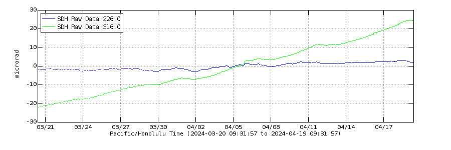 ?fileTS=1716006676
http://www.mounts-project.com/static/data_mounts/kilauea10/2024/kilauea10_20240503T161643_20240515T161643_VV_ifg.png
Most recent INSAR from May 3 to 16, showing major uplift. The ERZ connector is not evident, it being seismically active appears to only be a reaction to pressure but the uplift at local stations on the Chain of Craters seems to be response to the uplift along the upper SWRZ connector. As a reminder the last INSAR at Kilauea from April 21 to May 3 saw 12 cm of uplift centered south of the caldera a bit further south than the above image, which shows an additional 9 cm. So about 20 cm in the last month at the south end of the caldera.
The area that is highly seismic right now is also where the January/February dike started from. I had made a prediction back then that the volcano would be ready to go again in May and though I didnt expect the ERZ to get involved it seems a good guess so far. The second part was a prediction for another dike in the same place again, a rifting event like in the middle ERZ in the 1960s, or indeed like Krafla or Svartsengi. The last dike didnt erupt but I dont think a repeat will be contained. This area has not been vigorously active at all in historical time only two dikes in 1974 and 1982 with the first one a brief but extremely intense eruption (>1500 m3/s), so it is uncharted territory. But if this is a rifting event especially reaching a relatively low altitude far below the floor of Halemaumau (which did happen in February) an eruption is almost a guarantee without something major changing.
Or it ruptures the caldera fault and goes off with a curtain of fire at the bottom of the south caldera wall near Keanakako’i in 6 hours… That can happen too 🙂
The SDH tilt meter is having problems with the shaking
New post is up. Nothing to see – or is there a caldera hiding in plain sight?
https://www.volcanocafe.org/ibu-an-overlooked-caldera/
This spectacular article of yours Albert deserves more time in the limelight, definitely one to dig up at a later date!
First VC article I got my wife to read, and now we have some new historic locations to visit our next Iceland trip, thank you.