Due to the ongoing Reykjanes activity, I’ve grown interested in subglacial Icelandic lava flows. When lava is erupted under an ice cap, it tends to pile up rather than flow away. It makes a conical or ridge-like mound of pillow lavas known as a tindar. When lava reaches the surface of the glacier, it starts to grow sideways, making a flat-topped mesa, known as a tuya. The height to the flat portion of the tuya is the former thickness of the ice. Sometimes lava can also flow under the glacier, making thick flows with irregular surfaces. The subglacial monogenetic shield volcanoes of Iceland are marked by mighty circular tuyas of up to 50 km3 in volume (one of Langjökull’s shields called Eriksjökull). Thorbjörn is a tiny tuya, Keillir is a tindar that did not breach the ice. Much of Fagradalsfjall is one tuya, and Herðubreið is a majestic, symmetrical tuya that emerged above more than 1 kilometer of ice. Large fissure eruptions leave behind long rows of tindars and explosion craters plus fissure-fed tuyas and fully subglacial flows with irregular branching shapes. Of the things I’ve noticed about Iceland looking at subglacial flows, the most surprising by far has been the fissure swarm of Kverkfjöll.
Kverkfjöll
Kverkfjöll is one more of several basaltic caldera systems in Iceland, together with Hofsjökull, Hamarinn, Bardabunga, Grimsvötn, Katla, Askja, and maybe others. It’s topped by twin calderas, each being an elliptical crater of about 6 km wide and 8 km long. Historically, it hasn’t shown much activity, but if we look before the current interglacial period, we find a prodigious caldera volcano that has nothing to envy from its neighbors.
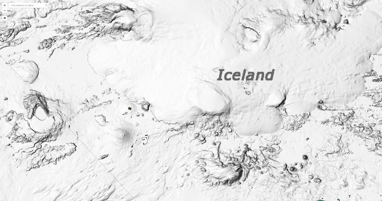
A mighty ridge of tuyas extends 200 kilometers from Kverkfjöll caldera to the northern coast of Iceland. The tuyas cover entirely an area 10-20 kilometres wide to a height of a few hundred meters above the surrounding plains, the result of numerous fissure eruptions comparable to the 1783 Skaftar Fires.

The regions of major fissure eruptions from large Icelandic calderas are circled in red. I find the fissure swarm of Kverkfjöll the most impressive. It has an enormous extent and Skaftar-sized eruptions all over.
Within 10 kilometers of Kverkfjöll caldera, a few tens of well-preserved subglacial fissures intrude from the volcano, probably erupted towards the latter part of the last Ice Age. In this same region, there are a few postglacial eruptions too. These eruptions are of great intensity, with tall lava fountains and vast floods of viscous-looking basalt, probably evolved iron-rich basalts that are typical of large basaltic calderas. One, particularly fresh-looking, eruption featured lava fountains over 500 meters tall that tinged in black pumice would have showered the surrounding landscape. About 0.1 km³ of basalt lava erupted in a very short amount of time making a 5 meter-thick flow of aa lava that was one whole moving mass of molten rock and rafted fragments of crust. This represents a typical eruption of Kverkfjöll. And probably a typical eruption of an Icelandic caldera. Such eruptions probably issue from circumferential fissures too, around the twin calderas of the volcano, but are hidden beneath the ice.
Beyond 10 kilometers, the number of young fissures rapidly drops down. Here starts a chain of glacially eroded tuyas and some very long chains of young-looking tindars that reach a distance of 200 kilometers from the volcano. These are probably all caldera collapse events. Once the volcano reaches the tipping point of a caldera collapse, all the magma in its shallow chamber can be squeezed out, making in this case extremely long dikes of about 2 km³, or maybe more. The tuyas are massive but most are relatively eroded and overlapping so it’s difficult to tell when one flow ends and the next starts.

There are four sizable outbreaks among the little eroded subglacial lavas of Kverkfjöll, which I think may belong to the same event since they all line up. The largest of the four outbreaks is located by the sea. It forms a vast tuya with perfectly visible edges. This tuya erupted though 100-150 meters thick ice and has a large volume of 20 cubic kilometers. The three other outbreaks comprise a chain of tindars, one 150 meter thick tuya with a deep explosion crater in the middle, and a 500 meter tall tindar that is the closest to Vatnajökull. These have volumes of 2.5, 2.5 and 1.5 km³ respectively. Since all four subglacial lavas line up, it’s possible they were formed in the same eruption.

The location where the 20 km3 tuya of Kverkfjöll flows onto the northern coast of Iceland.
This old erution of Kverkfjöll could be comparable to the 26 km³ Tjorsa lava of Bardarbunga/Hamarinn, which is the largest caldera-forming lava flow in Iceland during the Holocene. Could Kverkfjöll really have been responsible for such a large volume? If both the calderas collapsed to a depth of 400 meters, then yes. However, this is unclear. Grimsvötn’s recent caldera reaches 200 meters at its deepest and is mostly shallower than this, so 400 meters is not too easy. A possibility is that Kverkfjöll is a satellite feature of another system. If this was the case, then the best option would be Bardarbunga, which is slightly taller than Kverkfjoll and has a caldera larger than both of Kverkfjöll’s combined. A joint effort of the shallow magma chambers of both volcanoes would only require an average 200 meters subsidence, which, given Bardarbunga’s caldera is particularly deep among Icelandic volcanoes (up to 700 meters deep), it would not be too difficult and also explain why a relatively unimportant volcano has the biggest dike swarm in Iceland.

Edge of the large 20 km³ tuya from Kverkfjöll, near the northern coast of Iceland. From Google Street View.
Other little eroded eruptions along the swarm are mostly low chains of pillow lavas that extend discontinuously for long distances, making black mounds on top of the older eroded tuyas and flows. These represent events that are perhaps akin to the 1875 caldera of Askja, where the caldera collapses in a mostly intrusive manner and to a smaller volume. Among the older tuyas there are, however, many gigantic flow structures, more than anywhere else in Iceland for this kind of caldera-forming event.
Other large fissure-fed flows
The area known in VolcanoCafe as the Dead Zone is unsurprisingly host to many large subglacial fissures. Most of them seem mixed effusive-explosive eruptions formed by tindars with large explosion craters. The majority, if not all, of the little-eroded fissures likely come from Bardarbunga and Hamarinn (Hamarinn being a satellitic feature of Bardarbunga?). I measured one 30 km long fissure and its lavas, which shows a volume of 5 km³. There are 2-3 other similarly young, similarly voluminous fissures, which cut the area between the edge of Vatnajökull and Torfajökull. Southwest of Hamarinn, there are some large lava flows with a distinct broad branching shape and relatively low thickness for subglacial flows. These seemingly flowed beneath the ice, or maybe the water of a lake. I measured three of these lava flows and they have volumes of around 2-4 cubic kilometers.

Sizable subglacial fissures are also very prominent between Torfajökull and Tindfjallajökull, comprising more than 20 well-preserved tindar ridges up to 10 km long. I measured one at around 0.4 km³.
But the most striking subglacial lava flow in the Dead Zone is located northeast of Katla, its upper part cut by the Eldjá fissure. This lava flow forms a mighty tongue of lava 30 kilometres long, 5 kilometres wide, and up to 250 meters thick, it has a volume of 22 cubic kilometers. It formed a tuya only around the vent and the rest of the flow was built below the ice. Given its location, Katla may be the most likely source, although it could also be from Bardardunga-Hamarinn.
One last major fissure-fed flow is found elsewhere, northwest of Askja. This lava lines up perfectly with the large 2 km³ Frambuni eruption of Bardarbunga from around 1200 AD, so must have been a caldera-forming event of Bardarbunga. The subglacial flow comprises 12 km³ above the present-day plain, although originally it may have been a bit more since it’s surrounded by postglacial lavas.

Late glacial lava flow of Bardarbunga forms a kipuka within postglacial lavas, located west of Askja. It has a lava volume of over 12 cubic kilometers.
Best digital elevation map of Iceland:
https://livingatlas2.arcgis.com/arcticdemexplorer/


Back to present times, the second vent might have stopped.
4.7 quake in New York
My home is about 25 miles due east, as the crow flies, of the epicenter. Here there was a loud low-pitched rumble and the house shook. Three of us were home at the time. Definitely a “What was THAT?” moment. Fun!
There’s a commuter train line within eyesight of my house, so my first thought was that there could have been a derailment or a collision between trains.
At one time I lived in San Francisco and experienced a M 4.3. It happened when I was at the office, on the 11th floor of an old building. Though the magnitude was less, that one actually caused cracks in masonry of the building across the street. As far as I’m aware, today’s quake did almost nothing. San Francisco’s city center is largely built on landfill while this part of New Jersey is underlain by basalt left over from when New Jersey kissed Morocco goodbye when the Atlantic opened up. Big difference.
Exciting, but no damage.
Geologyhub just did a video on it. Apparently related to the Ramapo fault line/lines which are an aftermath of geological perturbances 500mya.
This was my first unambiguous quake that I felt, and I was in NW Connecticut at the time. No damage, just an interesting experience.
It reminds to the risk for major eastern Northamerican earthquakes like the 1929 one near Newfoundland: https://en.wikipedia.org/wiki/1929_Grand_Banks_earthquake
While most earthquakes happen along the Northamerican part of the Ring Fire, some exeptional earthquakes occur in the east.
The cone has ceased to be open on one side and now has a wall all around it with an opening at the base where the lava channel exits. It formed a sort of “bridge” over the channel, which then expanded to become a continuation of the wall. This happened at Litli Hrutur and with some of the earlier Fagradalsfjall cones as well. What causes this?
Further, there is a line down the middle of the “bridge” section of the cone wall, above the exit for the lava, somewhat irregular, that emits a lot of vog. That, too, happened with the Litli Hrutur cone and I think some other recent ones as well. What causes that?
B. Bound:
My own personal comment here. The spatter from the center of the fissure vent splashes onto the side walls, and the lava freezes into a permanent structure. This you see, as the wall of the cone is built up. If you took time lapse videos, you could see the spatter building all parts of the cone edifice.
The “line down the middle” actually shows us the power of very hot gases to actually permeate and intrude into supposedly solid sections of lava. This vapor is so hot that no solid lava material can withstand it, and so it intrudes. I saw this at La Palma, in the Canary Islands, and I saw this several times in Iceland. Once, in the La Palma incident, I saw a burst of very hot gas actually completely penetrate the cone and be exuded. Very hot gases are far more powerful than we realize.
This happens a lot above lava tubes in general, its as Randall says where the gas still present in the lava seeps through the roof although it is most likely using cracks rather than truely seeping through the solid structure, spatter cones arent very solid still just more so than tephra cones that are basically piles of sand at the angle of repose.
There is also some element to being on sloped terrain that causes visible degassing of tubes too. At Kilauea during the many times lava tubes developed from Pu’u O’o the tubes that flowed south were often clearly defined all the way to the coastal plain at times as far as 8 km from the source vent depending on flow direction. But the tubes on the coastal plain were badjcally invisible immediately even if they became defined and mature all the way to the ocean like in 2017. Similarly the lava flows in 2007 and from 2013 to 2016 that flowed to the northeast of Pu’u O’o over the much flatter terrain north of the rift would also only show visible degassing from the tube on the actual flank of Pu’u O’o within 1.5 km of the source vents where it was a lot steeper, even through identical composition lava in 2013 and 2016-17 flowed south and the tubes were obvious as far as 7 km away…
If I had to guess, tubes on flat ground are probably completely full to the rim and move slowly, and degassing basically is never focused anywhere enough to make visible plumes. On steeper terrain the tube is probably not full to the roof when mature and likely also erodes the base in addition. So there is air in the tube too. There also seems to be a correlation between long lived skylights and lavafalls with plunge pools in the tube, which would cause turbulent flow. Apparently temperatures of over 1250 C have been measured at skylights on Kilauea so air getting into the tube is far from inert and is probably causing all sorts of oxidation reactions. But in the end you hace basically a lot of hot air that will be blowing out of the skylights, its probably all the water vapor co densing immediately in the open air that makes the plumes. I do recall at ocean entries on Kilauea sometimes degassing would resume just inland of the sea cliff, where presumably the tube can cut down and allow air to enter like it did on the slopes inland. On top of this at the eruption in Iceland now it is really cold too, -3 C in Grindavik, so that water vapor is going to condense to ice which is very visible even more than water vapor, which is probably why high altitude or high latitude basaltic eruptions look so smoky compared to lava at Kilauea for example.
So basically long story short the plume on the front of the cone is a lava tube with air inside it and it is really cold so the air escaping gets immediately quenched and condensed to ice in the open air.
Is the lava hotter or have the webcam settings been altered? There is more white hot stuff on the webcams
Source: https://www.livefromiceland.is/webcams/fagradalsfjall
The vent made for interesting watching between 5pm and 5.30pm. At first the lava was very high in the vent, at times overlapping the edge and flowing out and making some big bubbles. Then the hole at the bottom of the vent started to flow differently. I think it got bigger because a lot more lava began to flow out and the level of the lava inside the lake clearly dropped. Then the lava had some big over spills. Then finally the hole in the lava started to get covered over, until now it looks like it’s almost drowned. I think from watching that the flow out of the vent has pooled a lot more lava in the high perched bit ans that is why there looks like more.
Tomorrows timelapse from the Live in Iceland cameras will be interesting.
The leakage to the north cannot be ignored either. There is significant outgassing occurring, and this definitely shows that lave underneath the ground is still moving around. During an Isak Finnbogason drone flight, he accidently stumbled on the dull red ground while scanning over a crack. Lava is still moving around and the surface gas emissions reveal this.
Looks now a bit like Masayas now gone lava lake inside the cone.
Is there any circulation going on? Looking at Isak Finbogasons drone flight the activity in the cone looks much more violent then the outgoing flow of lava.
I remember finding that long mesa near Myrdalsjokull a while back and wondering if it might have been a lava flow, maybe a huge evolved flow coming from Torfajokull or being a part of one of the central volcanoes during their embryonic stage when eruptions were more randomly distributed.
I figured it was probably just coincidence and the result of erosion on an old structure but if lava can actually flow under a glacier away from the vents like that then it brings up a lot of interesting possibilities. I had always assumed Laki sized eruptions in the glacial periods were explosive and the ash was carried out to sea on the icesheet to remove most of the evidence, but even a lot of historical eruptions in that setting are only very minimally explosive. And the larger VEI 4 eruptions in many cases erupt fast enough that the eruption likely would have been quite explosive anyway if maybe not quite as much or as big in volume.
Maybe this is from my own assumption that all of the Icelandic large central volcanoes are basically Kilauea but less active and with different amounts of alkali metals in the magma. In reality the only Icelandic caldera that can probably fit that description is Bardarbunga with its high MgO and very hot plume basalt. All of the others are rather more evolved and in many ways behave more like very flat stratovolcanoes, which is likely what they would be without a caldera.
Its somewhat basic in geochemistry but making a map of the active Icelandic volcanoes showing the MgO content of the lava, and maybe a similar one for (Na,K)2O, would be a good way to look at their relationships to each other. Otherwise it is just ‘plume basalt and MOR basalt’ which is very ambiguous and kind of implies we dont know the real answer when we are just looking the wrong direction…
These subglacial lava flows and fissures are easiest to see in topography, although I show them in Google Earth I first detected them in Arctic DEM. Looking at Google Earth alone, I may have never noticed these features.
“I had always assumed Laki sized eruptions in the glacial periods were explosive”
All of them seem to have an important effusive component, but many also have explosive craters, so may have also generated plumes of tephra.
“It’s somewhat basic in geochemistry but making a map of the active Icelandic volcanoes showing the MgO content of the lava.”
I could try to work something out. But if I publish it here, it would have to be a reduced selection of the existing data, or otherwise the reference list could end up being far longer than the article itself. Personally, I picture Icelandic volcanoes like rift Sierra Negra volcanoes. Chemically, Icelandic calderas are closer to Galapagos in chemistry because they evolve the basalt in their large upper magma chambers by fractionating plagioclase and pyroxene to Mg-poor, Al-poor, and Fe-rich basaltic composition. The resulting basalt is viscous, maybe gas-rich? and more explosive. Sierra Negra doesn’t have the silvery sheet pahoehoe of Kilauea and Mauna Loa cones, and in its south flank has cones with lava fountains over 800 meters tall, something you never see in Hawaii fissures, but happened during the Skaftar Fires in Iceland. Most Icelandic calderas are also bigger than Sierra Negra, so can feed more intense eruptions.
In Hawaii, the equivalent to most Icelandic calderas or Sierra Negra would be the evolved basalt that came out early in the 2018 eruption, or the most evolved basalts from the 1955 eruption, but coming from small sills rather than the large central chambers of Galapagos and Iceland. Iceland does have shield volcanoes with very primitive lava, though, and probably not all calderas are the same.
“Chemically, Icelandic calderas are closer to Galapagos in chemistry because they evolve the basalt in their large upper magma chambers by fractionating plagioclase and pyroxene to Mg-poor, Al-poor, and Fe-rich basaltic composition. The resulting basalt is viscous, maybe gas-rich? and more explosive”
Indeed explains why many Iceland basalts from central volcanoes and mature fissure systems never forms the silvery sheen yes, those superfluid lavas only emerge during eruptions without large shallow stoorage. 2021 was the first time in my entire lifetime that Iceland had very very fluid smooth lavaslike you see in Hawaii, 2014, 2011, 2010, 2004, 2000, 1998, 1996 where magmas from crustal stoorage so alot more evolved viscous compared to the mafic olivine picrite of summer 2021 that was basicaly a dygnja”sheild” magma. Many ingainary icefree eruptions in vatnajökull woud remseble Etna or Fimmvordhals in apparence I guess and specialy so for Grimsvötn that erupts cool midly evolved basalt
There are videos of the lava at Sierra Negra in 2005 and some in 2018, it is very fluid, not particularly like the early 2018 lava in Leilani Estates. Same at Fernandina which does have a lot of shiny pahoehoe. The lava of Holuhraun also does have a lot more pahoehoe than I thought, it isnt as shiny as the Kilauea stuff but then the 2021 lava doesnt look shiny on google earth either so it may just be that the high latitude doesnt illuminate the surface the same way as it does in Hawaii.
Galapagos is low latitude and Sierra Negra, which has the most tendency to erupt evolved basalt among the Galapagos, has practically no silver-colored lava. Unlike Mauna Loa where within 1 km of the vent the ground is a field of silver-colored pahoehoe.
Fernandina does erupt more primitive lava than Sierra Negra, although still more evolved than Hawaii from what I’ve seen in the past in GEOROC data. A way to compare could be looking at Landsat images and use a band combination to highlight shiny pahoehoe.
I see a small young shield volcano NE of Askja that has bright colored-pahoehoe, dulled somewhat by tephra cover but clearly different from Askja pahoehoe, which in turn is rubbly, dark and very minor.
Fagradalshraun in summer 2021 had lots of fluid shiney pahoehoe, some where superfluid there are lots of photos in daylight showing it to be extremely shiney and metal looking, sunlight is less common in Iceland as its cloudier than Hawaii… more stratus clouds so you does not always gets an intense sunbeam on a fluid lava flow, but those photos exist. I guess very akin to the fast supply magmas at Kilauea…. and looks the same too. This superfluid sheild magma have not been seen since, but coud arrive at anyday in the ongoing eruption that dredges up deeper materials, the mgo content is an important value if basaltic magma is very primtive
https://www.youtube.com/watch?v=idCV34yFwOQ
Nice video showing how fluid the 2021 s stuff became towards the summer months, its a real flood and very similar to halemaumau and nyiragongo lavas in behaviour I guess very fluid, crystal poor and glasss like was hot crystal poor materials dredged up after months of eruption flushing out the more crystal rich stuff, its perhaps not a direct astenosphere eruption but it was very deep, the current eruptions is from same source but dredges up older materials with it, the current lava is not as fluid as 2021 but have gotten alot more fluid since the start a few weeks ago. The magma source is still inflating under the current eruption and its an open canal now so I see good possibility of this lasting months, even many years, grindaviks future of existence is far from certain if the current show becomes a years long event, which maybe true even if its watch and see situation. Its now roughly at pahoehoe eruption rates, perhaps shomewhat more and a perched lava pond is feeding an inflating Aa field that now haves spiney paheohoe breakouts like holuhraun
https://www.windy.com/sv/-Temperatur-temp?temp,65.520,-18.523,7
And current Iceland weather, poor Icelanders having horse turd weather even in April, and its suprisngly cold for souch an oceanic locale I guess the polar vortex is weak again this winter and allows freezing air to spill out in all directions,l as was the case in the crazy cold 2022 Iceland winter as well
Didn’t la palma also have extremely fluid lava? That stuff was gorgeous.
Yes that was the low sillica basanite towards the end of the eruption after the tephrite been flushed out from the system, but the viscosity was not less than fagradalshraun 2021 near vent and halemaumau
I went back to a video that showed the first day as a timelapse, the lava back then was just as fluid as later stuff where it flowed in channels, but that is the key part as early on there were lots of vents and lots of tall fountains, so few channels. The viscous looking lava in every case I could find was all rootless spatter flows where the sides of the cone failed and slid downslope, not flowing directly from a vent. That happened a lot at Pu’u O’o too with similar results, and on Etna in 2021, where the lava often slides down the flank and turns into a glowing avalanche.
The only real difference between tephrite and basantite that I can find is the olivine content that is usually found in the latter. The main thing really is that these lavas have more volatiles than tholeiitic basalt so the fountains are huge and a lot more ashy than what you would expect of such a fluid lava. The tallest fountains in Hawaii are around 600 meters but I think there was a point in the Tajogaite eruption (not sure if that ever caught on) that the fountains got over 1 km. Fountains that big are seen at volcanoes with more viscous or crystal rich basalt, or with extra water after subduction, but neither was the case in this situation. Even if that 1 km number is overestimated I know someone on here at the time uploaded a picture of a 700 meter fountain 🙂
Its very interesting how active Kverkfjoll was in the last glacial compared to now, and that it had such a long fissure swarm system. None of the currently active volcanoes seem to consistently intrude so far like that, Askja did one into the same northern peninsula as the big Kverkfjoll tuya but that was probably part of the rebound melting after deglaciation than a typical behavior of Askja. It is even more a mystery that Kverkfjoll doesnt really indicate it had a greater magma storage capacity than its neighbors today, even less in a few cases, yet it was doing massive eruptions half way across the island and regularly enough to make a whole mountain range.
I wonder if maybe if the ice cap is part of it. The ice would have been over 1 km thick at Kverkfjoll in the last glacial maybe even more, where now it is hardly there. Holuhraun erupted only in significant volume beyond the icesheet, even though the ice craters in the glacier suggest the dike erupted much closer to Bardarbunga where the bedrock is at a lower elevation too. I do wonder what Holuhraun would have looked like if the ice wasnt there, if the main vent would really be so far from Bardarbunga or if there would even be a centralized vent at all rather than a longer fissure with many smaller lava fields i stead.
I guess another related reason for Kverkfjoll being so quiet in the Holocene compared to what it could do before is that if its rift zone is so elevated due to the subglacial activity the central volcano might not be tall enough to erupt there anymore, only close to the caldera. If the icecap was basically adding an extra 1+ km of elevation then that could have caused a preferrence to erupt on the rift.
Its interesting to wonder about how this might affect Bardarbunga in the future. Vatnajokull by some estimates might be mostly melted by the end of the century, and even conservatively will be mostly gone in 200 years. The big lava floods of historical time in the dead zone have all basically happened just beyond the ice. The next rifting cycle at Veidivotn is probably going to happen at some point in the 21st century or first half of the 22nd, but if ut does that with much less or no ice the result might not be a long fissure in the dead zone but instead a fissure much closer to the caldera, and possibly a very voluminous flow if the intrusion can just go mostly up instead of sideways. It may also be from Hamarinn, which seems more primed for a big eruption.
That’s a cool idea. I think when specifically relating to why Kverkfjöll (*just realized I’ve been missing a k out of the name this whole time) the long swarm of Kverkfjöll is the easiest way for Vatnatjökull to intrude a long distance into the MAR.
Not sure how to explain it clearly, although I think you will get this comparison. It’s a bit like how can Halema’uma’u make the longest dikes? Keaiwa or 1868 and such intrusions, they follow the SWRZ but offset from the main rift following it outside on a non-detached path from the source evading the swarms of Puu Koae and Kamakaia (say Askja and Krafla), which control the central section of the rift. The ERZ instead is too far away, so dikes end up short like Kilauea Iki (the Dead Zone).
The ice could have had an effect on the magma paths. 1 km of ice is equivalent to 300 meters of rock. If the ice cap is thicker over the volcanic plateau, then the magma could have been pressured into a long path towards an exit. The main issue can be that the magma has to stay liquid while traveling that distance. That requires a wide dike/rift, and that too can come from extra pressure on the magma chamber. It might also mean a fairly rapid, high flow rate eruption which would end quite suddenly when the pressure drops below the minimum required for that path length. In the case of Laki, the dike reformed during the eruption sequence, so that the eruption could resume. Thinking about it, not dissimilar to the Grindavik series, just with massively more volume
Yes, but the cooling potential of the ice is also a lot greater than 1 km of rock too. And in either case there is still 1 km of solid material between the bedrock where the eruption is and the atmosphere. Which is very probably why it looks like Vatnajokull and Katla only do big eruptions, the small ones dont melt through.
I guess it is just hard to really test this. Antarctica has some volcanoes in similarly glaciated condition, but dont look to be rift volcanoes. And we dont really have high detail views of the bedrock there anyway. And Iceland has probably erupted between 500 and 1000 km3 of lava since the last glacial ended and the volcanoes most responsible must have changed greatly in that time too. Bardarbunga might have been a massive tuya or shield that has since collapsed probably dozens of times. And Grimsvotn did whatever the Saksunarvatn tephra was made by, which it has possibly still not really recovered from.
Is it possible Grimsvotn and Kverkfjoll interact? Grimsvotns fissure extends a bit north into the glacier with Gjap and Greip. At least it looks that way with the map in this article. https://www.volcanocafe.org/the-woolly-mammoth-sized-eruption-poll-one-year-on/
If the magma is a similar composition then that is a possibility. But I had for a while considered that to be the case for Grimsvotn and Bardarbunga but the MgO content is very different between those two (4-5% vs 7-9%) and that is for two volcanoes that do actually have an observed interaction…
I havent looked at this too much yet and Hector will probably beat me to making a map but my general observation is that Bardarbunga is highly mafic and is the dominant plume volcano, erupting tholeiitic basalt with a MgO content of about 6-8% that is very similar to Kilauea and Mauna Loa, and the magma storage is very hot probably over 1200 C similar to the Hawaiian volcanoes. But the others are actually not pure plume basalt at all, Grimsvotn and Askja both have lavas with about 4-5% MgOand that includes the Laki lava, which is about the same as the evolved basalt erupted at the start of some of Kilaueas rift eruptions, magma that had sat there for decades. Katla has a similar magma, and MgO content. I have not checked Hekla, Torfajokull or Krafla, which are also intraplate central volcanoes like Bardarbunga, but Reykjanes seems to also have high MgO, 6% for the intense eruptions of Svartsengi and nearly 10% for the 2021 lava, and maybe also the lava now too.
If you look at whats under the ice. There is a ridge that connects Grimsvotn and Kverkfjoll. On each side there is a valley. Besides where gjap connects Grimsvotn and Bardarbunga
Wow the Gjalp hydroclastic pillow lava ridge is even visible in that topographic map, 700 million cubic meters of lava, it maybe almost a small embyonic satelite volcano by its own as the same ridge have erupted many times, but its more or less a pimple of the giants that are Grimsvötn and Bardarbunga… woud be fun with a glacial surtsey tuya that goes effusive, but eruptions here rarely last long enough and are not very big in volume the summit glacier, still grimsvötn 2004 managed to make a little island in the meltwater lake… but died before it vent effusive
Great map jbean. Greip isn’t very visible (if it is a proto-volcano).
It’s very unsure what many of the structures outside of the main volcanoes are, Hamarinn, Thordarhyrna etc. Is Esjufjoll it’s own edifice? Hard to tell, I tend to think of them more like a Mauna Ulu or a Pu’u Ōʻō in the line of each of the ‘proper’ volcano rift zones.
They are a bit like the Pluto of volcanoes.
Thought Hamarinn was a caldera, but looking at that map, it doesn’t seem so. The big three are Grimsvötn, Bardarbunga, and Kverkfjöll.
There isnt really anything at all above Greip, only a graben that is where Holuhraun erupted from and which seems to be long lived just unrecognised as part of Bardarbunga before. Greip is probably a part of Bardarbungas magma plumbing, which might also give credibility to it being connected to Kverkfjoll as was speculated in the article though doesnt prove it either.
It also seems like Greip is pretty quiet. It is probably something like the Pahala quakes, which are very probably related to magma rushing into Kilauea to refill it after 2018. Greip was the same after Holubraun, caused by massive supply to refill the magma chamber. Just that Bardarbunga either filled up again really fast or Greip ran out of spare magma. Kilauea by comparison is still going full force, and may do so for decades longer.
Neither look like proto volcanoes to me at least.
If you look at a digital elevation model it seems the ridge at Hamarinn is a caldera rim. https://livingatlas2.arcgis.com/arcticdemexplorer/
https://www.youtube.com/watch?v=FZmN2daZW9g
https://www.youtube.com/watch?v=I5JBPyrjmaE
Eruption webcam
Thank-you for the view on the (hi)story of this Vatnajökull volcano, Hector!
The length of the main volcanic systems with their lava flows is very impressive! 200km from the volcano to the northern coast of Iceland is a unbelievable long distance! Bardarbunga did lavas until the South Coast and close to the North Coast of Iceland. The core volcanic systems of Iceland nearly crosses the whole island as the small systems do on the Reykjanes Peninsula. Also Krafla and Askja have very long systems and historical lava flows.
Thanks!
I was impressed by the length too, as well as the amount of large lava flows that erupted during the Last Glacial Maximum. As well as the last 26 km3 flow that is so well preserved and erupted through such thin ice that I wonder if it’s Younger Dryas in age.
The length of the fissure systems and lava flows remind to Mauna Loa. Are there any other comparable long volcanic systems on earth like on Iceland?
Some East Pacific Rise volcanoes might be similar or even longer. And of course, some large igneous provinces produced dikes up to 3000 kilometers in length, radiating from layered intrusions. Like the CAMP, its central magma chamber ended up in Freetown (Sierra Leone), while the dikes reach as far north as the Iberian Peninsula.
Map of the MgO content of the Icelandic volcanoes, it is incomplete and basic, and not all of the volcanoes are included due to lack of obvious information. But it does give a pretty good look at it all. I also put in the rough location of the primary plate boundary in white.
https://i.imgur.com/W1qT79P.jpeg
The colours are based on a gradient of 20 hex codes between #0288d1 (blue) and #d90000 (red) on this generator
https://colordesigner.io/gradient-generator
Basically the more red the higher the MgO.
https://imgur.com/W1qT79P
If someone could make the image displsy 🙂 usually works but not this time for some reason
Do we notice MgO by white colors on the lava field or is the white color caused by sulfur?
Thank-you Chad for the map and description! It shows well the volcanoes with immediate link to mantle magma (high MgO) and the volcanoes with intermediating magma storages. Is Hekla the red or blue point noth from Myrdalsjökull?
I will probably update this map in time to include more of the volcanoes, the dots are basically just locations that just gave a simple percentage and I took the average or the most common number if a volcano had variation. And then it still had to be rounded to 0.5 out of 10 to plot on the colour gradient too.
Hekla itself is the blueish spot. It is the only non-basaltic sample on the map too as I realised afterwards that evolved magmas will always have low MgO if derived from fractional crystalization of basalt, so Torfajokull and Oraefajokull which are mostly rhyolite would be basically 0% MgO. The red dot next to Hekla is one of the 1913 fissures, because those probably represent the parent magma for Hekla and are highly magnesian, nearly as much as for Reykjanes and Bardarbunga, between 7.5% and 8% MgO. Fimvorduhals is also there too and is similarly magnesian, so a similar magma likely feeds all of the volcanoes in the general area although it isnt homogenous.
I think this map and the data for it does basically prove the huge fissure eruptions do originate from crustal storage under a central volcano and not direct mantle decompression too, Eldgja was not highly magnesian like the Hekla fissure swarm or Fimvorduhals eruptions. Basically Eldgja was a bigger Holuhraun, not a bigger Fagradalsfjall. It is though notable that both Laki and Eldgja are slightly more magnesian than the caldera eruptions of their parent so it isnt just as simple as the magma chamber leaking into a crack and does involve lower levels of storage, just like Holuhraun.
https://www.wionews.com/science/gigantic-ocean-found-700km-below-earths-surface-706834/amp
Looks like there is lots lots lots of water locked up in Earths mantle in minerals bounds..
Jesper:
There is an unexplored topic of carbon sequestering in the magmatic material, apparently at high temperatures and pressures, the carbon molecule has a larger role to play than most people realize. I was talking with a federal research scientist a couple of years ago, and apparently carbon plays a larger role in volcanics than recognized.
See https://www.ncbi.nlm.nih.gov/pmc/articles/PMC5856773/ as an example. There is much carbon sequestering going on in the Western USA.
Randall
Can we determine which tuyas … are remnants of explosive and which are remnants of effusive eruptions subglacial eruptions? An explosive phretomagmatic Surtseyan (glacial or marine) eruption begins as an effusive eruption until it reaches to the importan point of low water pressure that allows the switch to explosive activity. Is this point of change visible?
I kinda assume that if they have craters, activity was explosive (plume above the ice?), which is very obvious for many Dead Zone fissures. But I’m not sure which is the best way to tell.
If Hector is right about Kverkfjoll, that means Bardarbunga has a total eruptive rift length of about ***300*** kilometers. Even the Hawaiian volcanoes peak in ballpark of 200km of rift length, although they of course have a *much* thicker pile. But Bardarbunga is an absolute monster. This site likes to talk about Grimsvotn, but even if this isn’t the case, Bardarbunga is by far the most consistent Laki-type erupter in Iceland.
Which is another thing to think about in terms of predicting the next Laki. Grimsvotn system is about 250 years removed from its last great eruption. Bardarbunga 550 years from Veiðivötn. In the grand scheme of things Holuhraun isn’t *that* big especially since the caldera collapse in large part made up for the withdraw and we are entering another cycle of increased supply.
Yes Bardarbunga is simply a way bigger volcano. Grimsvotn in a typical year isnt really that impressive, im honestly not really sure where some of the old claims on here originated, I was there lurking at the time and have wondered about it and researched it ever since but ut just… doesnt really make sense…
Veidivotn is probably due to rift at some point in the next century. Bardarbunga itself might be out if action for the rest of this century, but Hamarinn is probably primed to go if such a rift initiates. Torfajokull also has shown inflation too, its not very active but certainly not dead. I doubt we will see another eruption as big as Laki next time, the Veidivotn eruptions after Thjorsahraun are all pretty big but Laki was still more than twice as big again, having it and Eldgja within the same millennium really is kind of a massive black swan.
My thoughts are what is going to happen if Vatnajokull melts before the next event, will the eruption occur close to the central volcano instead and just flood the area with lava instead of making a long fissure?
Grimsvötn fooled us a bit by the period 1996-2011. Historically there were many local Vatnajökull eruptions which weren’t linked to a certain volcano. Grimsvötn has low times and high times. It can still do only a subglacial eruption with a jökulhlaup.
Last 30 years Iceland often surprised us. 1996 Gjalp. 2000 Hekla, 2010 Eyjafjallajökull, 2011 huge Grimsvötn, 2014 Holohraun. The only certain thing on Iceland is the surprise eruption …
Next time it will surprise us by doing just what we expected
Bardarbunga does the big eruptions more regularly (every 500 years?), while Grimsvötn does the ordinary eruptions more regularly.
Greip/Pahala a deep feeder then Chad?
There is an interesting topography south of Kverkfjoll.
Also looks like there is some sort of (old looking) edifice eastward of Esjufjoll, which may line up with Snaefell and must be the most eastward extent of the East Rift Zone.
Ah darn it this was supposed to be in reply to your above comment regarding Greip. Sorry!
Yes in both cases, Pahala swarm is much larger though and deeper, but Hawaii is built on old and cold oceanic crust which can flex and quake deep down, Iceland is where the crust is created so is necessarily going to be more ductile anyway, Greip might just be about where it becomes more solid and brittle, and it is about the same depth that this happens at Reykjanes too.
We can speculate only in the case of Greip, we don’t know what is happening down there at all.
Fact is that the intrusion prior to the 2014 eruption started with earthquake activity under Bardarbunga. Remarkable is the deep activity under Kistufell a bit north of Bardarbunga, going back to 2005 and stopped after the eruption totally. I would expect (and read about) a relation between those two instead of Greip and B.
Youtube video showing that spot.
https://m.youtube.com/watch?v=iWZtMYPTmdk
Kilauea also has a deep feed directly below it, the Pahala area isnt its only source either, the Holuhraun magma being derived from magma rising under the north rift of Bardarbunga doesnt mean Greip cant also be a part of the system. The dike that fed Holuhraun went through a graben that also seems to be partly above Greip, and might also be where Gjalp happened if it goes that far south. The graben is either filled by ice or sediment so doesnt show much but it is there, maybe it is structurally an extension of the Askja fissure swarm but is dominated by the Vatnajokull volcanoes.
Could. Yes. That is something else than Greip is the deep feeder.
There is a graben (icefree terrain next to the jökull) above the Holuhraun dike, but formed during the dike extending. There must be multiple grabens hidden, its cracks if deep enough, may be a path for a dike surfacing, agreed.
Bardarbungas radial fissures do, partly, penetrate the fissure system that is originating (mainly!) from Askja. Holuhraun has showed that the fissure systems cannot be assigned to one central volcano strictly. The dike just followed a route with the least resistance, apparently that route was in the Askja fissuresystem at that moment.
Steam means water. So perhaps the steam just shows where ground water has collected
Somewhere on the east side of Kverkfjöll must be the transition from EVZ to ÖVB (Esjufjöll).
We don’t actually know too much yet, on how nature works. Please see https://pubs.usgs.gov/fs/2007/3045/ in regard to boiling water at Hot Creek. I personally corresponded with a USGS scientist in regard to sudden heating at the creek, but this person had been taught to think that only deep thermal heat from below could cause heating. I tried to explain that sideways traveling energy could actually cause the sudden heating, but my suggestion was met with bafflement. If we are going to make progress on understanding nature, we need to think outside the box.
Randall
P.S.The recent degassing of the current fissure eruption shows us that there is much we don’t understand yet. No one, and again I repeat no one has explained why we see a persistent steam cloud day after day, near the center of the fissure lineament.
Ok, let’s make a hypothesis,
It is a huge dyke and at some places the dyke might just be a couple of meters (say 10 or 30 meters) below the surface. Gases (including supercritical water) might be able to escape through the bedrock and form a steam cloud at some places along the lineament of the dyke.
Another possibility would be that the current dyke works like a giant radiator and is heating the adjacent dyke from the previous eruption causing volatiles to escape.
I did actually say something about this the other day, that back when Pu’u O’o was active a part of the original 1983 fissure was always steaming well into the 2010s. It never erupted again though, the two fissures in the same area in 1997 and 2011 were new dikes that intruded outside of the feeder to Pu’u O’o.
This is not to say it is impossible for the fissure at Svartsengi to erupt somewhere else again in the current situation but it would be atypical. Most likely such an eruption would be from a close parallel fissure still even if it happens while the current cone is still active.
The more primitive the magma becomes, the more gas it contains and releases during the eruption. Water gas is part of the volcanic gasses and often does white steam plumes.
What we need (and still lack as of Monday April 8th, 2024) is the detailed chemical analysis of the recent lava emissions from the cone complex.
You can spot nice aurora on the Langihryggur cam:
https://livefromiceland.is/webcams/langihryggur2
April is the month in which we after the last major intrusion January/February 2024 should again take a look at Kilauea:
Yellow quakes (5-10km deep) have accumulated below the summit caldera. It looks as if the next intrusion is going to happen probably in the summit area.
The yellow quakes are magma moving into the summit chamber but that happens pretty unrelated to the location of eruptions. The shallower quakes are much more indicative, its not foolproof but generally the location of the quakes shows where the probable location of an eruption will be.
2020 eruption was preceded by strong quakes along the ERZ connector and under Halemaumau, where the eruption happened. 2021 eruption started with the same, ERZ quakes and also quakes at Kaoiki pali, but then the SWRZ connector lit up in August and the ERZ went silent, and then lava erupted in Halemaumau. The first 2023 eruption saw strong summit activity only and erupted there, as did the second although the SWRZ staryed acting up too. The September eruption was mostly seismic at the SWRZ connector but erupted at the summit still. But only weeks later the SWRZ started going again and has basically been the only part of Kilaueas magma system to show shallow seismicity ever since.
There is also the situation that the last eruption was theoretically perfectly located to last a long time, it was in the center of the caldera, not under the dense lava lake, and started at a very high intensity that was probably even higher than the Svartsengi eruptions. But it only lasted 5 days and didnt resume even when summit i flation did immediately. The same is true in June too, with a vent above the lake that lasted a lot longer than the intense part of the eruption and even got stronger as it lasted and then just stopped..
The fact the next event was a SWRZ intrusion probably means the summit is too elevated now and it takes less pressure to go into the rift. The last intrusion failed to erupt but the way things are going now that event will be recovered in a few weeks, it will be interesting if it breaks in the same place, it might erupt this time if that is the case.
It’s likely still to early to see significant volcanic activity in/on Kilauea. But I have the feeling that we should already should be cautious about any development there.
The intrusion of January/February had a very much higher rate than the eruption of September 2024. If Kilauea continues this trend, there may happen more short, but spectacular eruptions. The SWRZ still looks too weak for an eruption like around 1820, but the summit is always a good and easy bet for the next eruption on Kilauea.
In my view Halema’uma’u disappeared 2018 … and still has to be reborn. The lava lake and lava field that grew 2020 to 2023 don’t remind to the shape of the original Halema’uma’u. They were just summit eruptions. Future will show whether Kilauea decides to create a small caldera like Halema’uma’u inside the large Kilauea caldera again.
HVO and the Hawaiians in general still call the 2018 caldera Halemaumau. That name basically means ‘house of Pele’ as Hawaiian is not always exactly literal in translation. So basically it will always be called Halemaumau unless it is considered appropriate to change it culturally which isnt really our say in the matter, its a nice name anyway 🙂
1823 eruption was from the same crack as Mauna Iki, which is on the SWRZ but isnt fed magma from the SWRZ connector it is fed by lava lakes in the caldera. In 1919 the lava lake was relatively small so could only go so far and erupt slowly, a century earlier the lake was like the one today but as wide as the whole caldera to the cliff below Volcano House, much more lava, so when it drained it went much lower and gravity did the rest. Very similar to Nyiragongo.
If there is an eruption on the SWRZ soon it will be on the connector or a rift that crosses it, the summit still isnt full enough to drain out yet I think. But connector eruptions are also highly intense as in 1974, they arent voluminous but then that might also be because 1974 was isolated and the current setup is likely to be dufferent. I see it being much the same as the ERZ in 1961, where the whole middle section if the rift ended up being covered within a decade even though there had been basically no eruptions there for about 200 years at that point. The SWRZ surface is only 700 years old in most places, not really old enough to say we know what it will do with confidence, a 600 year outlook would have failed to predict the 20th century activity too.
Seems like the sill complex under Svartsengi is inflating again, even with the eruption ongoing. Ot will be interesting to see if it can refill all the way to reopen a new long fissure or if the open vent will relieve pressure earlier, or just have a massive paroxysm.
I see no problem of this eruption lasting years, even decades its an open conduit and magma is always flowing in and eruption is even less than the supply rates, it may keep going as long as magma is flowing in under svartsengi, if we gets high fountains then we gets another fagradals cone…or something even bigger
Yes, the supply would be high enough to sustain a shield eruption. So as long as this increased supply lasts and assuming the rift has been filled already (there have been six dike intrusions which is not as much as Krafla or Manda Hararo, but this dike swarm is also much shorter and with some of the extension already released by Fagradalsfjall) then we have a second shield eruption, maybe a longer one this time.
I tend to agree with you Jesper, but how far will this lava flow? I don’t believe it will reach the sea. I think what we are looking at is the beginning of a shield volcano.
The current relative low-level eruption can be the base for future episodic events. We are now in a similar situation like during the dormant times since December, but the conduit is open towards the surface, so that low-level activity can continue. The system can probably react very quickly without any warning if a new wave of magma enters the shallow system and makes a sudden volcanic spring tide.
On Fernandina, the lava flow is very close to the sea in the most recent image: (Sentinel 2, Copernicus, “False Color Urban” to highlight the active flow)
Very interesting it looks like a tube has formed and is feeding a slow pahoehoe flow downslope. Might be the first time this has happened at Fernandina since its caldera collapsed in 1968 too, so might be a sign of being recovered from that now.
Ocean entry is accomplished: https://www.volcanodiscovery.com/fernandina/news/238602/Fernandina-volcano-Galapagos-Islands-lava-flow-entered-Pacific-Ocean.html
Nice Whirlpool lava lake in the cone now with overflow of lava: https://www.youtube.com/watch?v=FZmN2daZW9g
Can lava erosion by the overflow erode the rim of the cone? In this case a lava flash flood would be possible with the risk of quick coverage of new territory that until now was spared from lava.
Crater overflowing now.
WOW
Mac
Started around 15:20
Mac
Is it an optical illusion by the backwater effect of the rising rim or is there more lava coming up in the cone?
Maybe the tube outlet at the bottom got clogged up and now the lava level rose up to the lip of the cone.
It will be interesting to see how long the cone will stay intact with that much flow going over the lip…
It simply boiled over
https://ibb.co/GRqHY7w
https://livefromiceland.is/webcams/fagradalsfjall
It does lava waves over the rim every 2-3 seconds. Likely depending on pulsing lava/magma support. Is this a sign of weakening, increasing or constant strength of the eruption?
I think it cleared a blockage and increased supply. If it is short or long term, that is beyond my skill set. The lava was flowing out the drain in the front when this started, and there was only 1 quake on the met page in the general area?
Mac
I was wondering if it could be a small episode, Mauna Ulu-Pu’u’o’o style. The sill has been inflating. With this, it may deflate while erupting at higher rates for a time. It could be the start of an episodic phase of eruption.
just wondering how long the walls of the vent will stay intact with all that lava sloshing around in there?
Mac
It began with soda, it burst into a flamethrower, and now we have a soup bowl. Iceland is fascinating. 🙂
I wonder if the sill under Svarstengi is starting to drain rapidly in the open conduit to the eruption site? Check GPS tomorrow , I guess …
How long is the crater wall going to last? The lava is cutting a fairly deep channel into it now.
It becomes narrower.
https://www.youtube.com/watch?v=QmsInGsDHZg Isak is flying wuth his drone
Hope he is a safe distance away on higher ground just in case the cone gives way …
He is in safe position, but today canceled because of wind.
I know it’s posted previously. Right now, with twilight, it’s mesmerising!
Where’s the lava going?
break out on the back? Sandholl camera
Looks like the whole back might go MBL multiview camera
Yup, looks like the back part split apart. Probably too much pressure from the high lava level.
Sandhóll Close up cam shows it best:
Going back in the Sandhóll video, it started at 21:30 with a series of small collapses of the rim. Then at 21:37, an entire section of the north wall was lifted up and pushed outwards, releasing two gushing flows, one on each side of the shifted block. The movement is slow, but if you increase the speed of the video it’s very obvious.
Exactly the same thing happened at Litli-Hrútur, leaving two lava streams around the shifted block. Those outlets were rebuilt in just one or two days, so the cone refilled with lava until the next collapse. I think we can expect something similar to happen here. Cone rebuilds, fills with lava, new collapse, rinse and repeat.
Looks like the back leak which some thought insignificant yesterday from drone flights overviewing the cone and surround area, has shown the weak spot in the cone structure. From what I can tell from the very jiggly Langihryggur Camera is that this started close to 21:30 pm local iceland time. I guess when we examine a live cone, everything needs to be carefully noted.
RUV has published the video with the onset of the different activity around 15:20 Icelandic time: https://www.ruv.is/frettir/innlent/2024-04-07-myndarleg-hrauna-rennur-ur-sidasta-gignum-409549
MBL camera Sandholl
I could watch that all night.
Definitely beats anything a regular TV channel could offer… (but then we’re volcanophiles).
Volcano soap?
A less complimentary term comes to mind: volcano porn…
The lava is flowing north now, but it’s hard to tell how far it’s gotten. If it goes far enough, it could turn west toward the Blue Lagoon.
I think we are watching preliminary stages of a shield cone developing.
Probably not yet, if lava flows northwards from the cone as ut is now it will be directed towards Fagradalsfjall. But if it becomes a shield like in 2021 with tens if not over 100 meters of elevation then it could end up flowing that way. Although I expect Grindavik will be in big trouble well before that happens in that scenario.
How far does Kverkfjöll’s system currently reach to the north? Your maps show that prehistorical eruptions/fissures happened on the northern coast of Iceland. The Catalogue Map only shows a regional size until the latitude of Myvatn.
Contrary to this Askja’s fissure system indeed reaches until the ocean, if the Catalogue of Icelandic Volcanoes is correct in this matter. But lava flows only get until the wetlands of Skinnastadir. There is a big river delta, where occasionally also lava flows find their end some miles before the coast.
Spurting lava eclipsing the moon eclipsing the sun from Isak Finnbogason in Iceland
It is pretty cool!
Isak is now sticking fly-paper on his drone to collect air samples. The University put him up to it.
21:26:30 a fox?
For All: I am the one that came up with the “Dead Zone” term. It’s just the region between Katla and Grimsvotn that SEEMS to be aseismic.
And yes, the movie title inspired the term. The other dragons were amused and it kind of stuck in our conversation.
Using “Heat3D”, a Java based program the USGS had up somewhere… i ran a series of dike emplacements over time to see what the residual heat might be there.
The crust is still warm enough to be ductile.
https://www.volcanocafe.org/the-dead-zone/
It is a good description. And it does a good job in explaining the lack of earthquakes without requiring lack of activity. A region that has seen Laki and Eldgja, plus ‘smaller’ eruptions, over the past 1100 years is clearly not ‘dead’. Just pretending.
Just saw the total eclipse in Dallas today… AWESOME
Etna’s rings: https://www.youtube.com/watch?v=ckFdAVFgIR8
Another substantial quake at Hofsjökull today. Anything interesting going on there? It always seems so sleepy but perhaps looks are deceiving. A bit lame not to have any seismometer or GPS meter there (or GPS at Snæfellsjökull come to think of it).
Holocene activity of Hofsjøkull: “The known Holocene volcanic activity includes 6-7 effusive basaltic eruptions, while no tephra layers have been traced to it.”
It prefers to do minor basaltic eruptions. More potential for explosive activity has in geological timescales Kerlingarfjöll which is a Rhyolite subsystem.
Today there is vital earthquake activity from Grindavik to Bláfjallaskáli (Brennisteinsfjöll). Does the activity of the sill cause some of these earthquakes? Or are they linked to the general awakening of the whole RVZ?
Not sure I would call all of the eruptions minor, one of them made a lava flow that reached over 20 km from the vents on pretty flat ground which would indicate a high intensity of eruption probably not unlike the start of the recent fissures but longer lasting.
Just watched this presentation by Val Troll, apparently Fagradalsfjall erupted about 3200 years ago (graph 3 mins in)
Fernandina’s lava flow did indeed reach the ocean.
IMO published a new lava thickness map with data from April 8th (yesterday):
I had been waiting for this! It helps to put the webcam images into perspective, i.e. the accumulation of lava all around the active cone…
Lava territory has remained at 6,14 km². It hasn’t expanded recently, but became thicker. The decreasing strength leads to local accumulation of lava.
Inflation increased last week, while the intensity of the eruption decreased. Does the sill get more magma than the eruption erupts now?
https://www.vedur.is/um-vi/frettir/jardhraeringar-grindavik
It would seem so uf this is to be believed
The inflation is slower than before, so evidently only part of the magma is causing the inflation. It also logically leads to the conclusion that at some point the eruption will intensify again. Still wondering if it will be by opening the fissure again or by the cone going into a paroxysm. The latter situation could probably occur before the deflation is recovered fully too, there is an open vent after all,
It looks as if the eruption has remained in a continuous state. At the same time Askja keeps on skyrocketing:
I think Askja will still be a while, it only started inflating a few years back and was subsiding since the Krafla fires up to that point I think. Not sure if that was coincidental or part of larger scale tectonic movement, maybe that extension is ultimately why Holuhraun was where Bardarbu ga erupted in 2014 too, a rift primed to start rifting.
Magma supply would have to be extremely high to cause an eruption there before 2030 I expect, and probably a harmless but very intense eruption from a fissure somewhere in or near the caldera. That being said if the quakes near Herdubreid are caused by inflation at Askja then things might be moving along quite fast.
A quick check with the NASA Firms (Lance) satellite shows Tofua Volcano (lava pond) still active, (Tonga Arc) and the Tinakula Volcano, Solomons Island also active.
Hello everybody:
I think this is new. Apparently Santiago Island, in the Galapagoes is showing new volcanic activity (April 9th, 2024) Please see and
and  . The NASA Firms satellite data shows today’s activity on Santiago Island.
Can someone please verify that this is new volcanic activity?
Thanks!
– Randall
That flow is from the 1709 eruption from what i’ve been able to find. Retracing google earth images shows the flow isn’t fresh. However the heat signatures are interesting as this could indicate some new activity.
Is it vaping or smoking? Anyway: I don’t think that these allegedly loveable volcanos are a good model for our youth.
Apropos, why was Fagrafall temporarily the worlds most crowded place while this event, much easier to access, has almost no spectators? Is the degasing so different? Or was it just another media hype with Fagra?
Its not actually that easy to access, there arent any roads that go near it.
I think also that a lot of the people in 2021 drove over and would have either stopped in Grindavik or stayed there after, which isnt an option now. If I had to put any reason on the lack of tourism it is because of what has happened in Grindavik in the past 6 months.
I think that’s only part of it. Add to the already mentioned reasons:
– The presence of deep, uncharted cracks in the ground (remember the worker that sadly disappeared into one)
– The fact that the sill is still inflating, which might open new, powerful curtains of fire, or possibly suddenly put the existing crater into overdrive.
– High concentrations of poisonous gasses.
– The authorities have closed the area and most people respect this.
For good reasons it’s not allowed for anyone to go there, except scientists, rescue workers and some journalists. Unfortunately, there are tour companies offering guided tours, even though it’s not allowed. The paying customers are turned away when the authorities discover them, but a few still slip through. If you see someone selling tours to the volcano, it doesn’t mean that authorities have opened the area, or that the tour operators have special permission to bring people there. They just do it anyway.
So the high concentration of poisonous gases wasn’t a thing with Fagradalsfjall?
There were warnings at times, but also the different terrain probably has an impact on accumulations.
Richard, you are saying that laying in a ditch, Fagra was LESS dangerous than the current eruption? With thousands of people sitting in a kind of stadium on the flanks of the surrounding hills?
(Also: There were new fissures opening around the later main cone, so the current eruption looks harmless compared to Fagra. No Sir, there must be something very different in the chemical cocktail that is exhaled by the two eruptions.)
If the whole current eruption was as weak as it is now, the risk of sulfur gas pollution wasn’t much higher than Fagrabunga. But the strong first days of the eruption in March left a big lava field with a lot of gas emissions behind.
Fagradalsfjall was situated in kind of a volcanic amphitheater with the surrounding “Viddar” (skandinavian expression for Highlands). On the ranks of this amphitheater the visitors were relative save against heavy gasses. The landscape of Sundhnukur is flat compared to this. It doesn’t protect against the flow of heavy gasses. The low altitude also allows fewer wind force to brush out the gasses.
It is probably a combination of flat ground, gas exposure, not walking on the new lava.
But probably 99% of the reason is to stop people trying to drive into Grindavik or over the gravel road crossing the new lava near Svartsengi. Even residents of Grindavik are now only allowed to live there at their own risk and only in the half that was outside of the November graben.
As already mentioned, the crowds were largely on the top of hills. There were times that one or more of the paths were closed because the gases could sit in the lower places and not be dispersed. It would also depend on the gases and whether they were heavier than air. While the gas spectrum is likely similar, there may have been periods where one gas may have been dominant and times where a different one was dominant. The indications from IMO are that gas levels are higher and that could be due the the reasons above, with the greater amount of lava from the earlier eruptions and the number or eruptions in a short period.
Realistically though, the greatest impediment is access, due to road closures, even though at face value, it would expected to be more accessible than Fagradalsfjall. Other hazards are probably a greater risk.
Fargradalsfjall was a friendly eruption, not threatening anyone. This is different: this is a destructive eruption with Grindavik is still in the line of fire. It is not a tourist eruption anymore.
So I’ve read 152 reasons why Fragradalsfjall (the sweet little scalawag) is o.k., the current one (the evil and mean one) isn’t. No one agrees that a crazy social media hype is a factor.
Here is explanation 153: It is what it is.
The most severe risk of the eruption is the gas pollution, although volcanic gasses usually are more friendly than coal fire gasses (f.e. Carbon monoxide). You can smell and feel them before you get danger to life. Carbon monoxide would kill before you notice … fortunately it’s not a volcanic gas.
Gas pollution of Sundhnukur volcano is apparently more dangerous and unpreditable than Fagradalsfjall. Fagradalsfjall was higher above the sea level with more wind speed that could better carry away the gasses.
CO2 is not that friendly; it lurks in hollows to catch the unwary.
Many people don’t realise how toxic CO2 is, including those in medical professions. I had a number of “discussions” over CO2 toxicity during COVID. There’s a very good reason why we have monitors in the lab.
Actually, CO2 is not that toxic and it does have an essential function in the body / blood as a buffer. Without CO2 / carbonate our blood would get too acidic, which is a dangerous condition (check metabolic acidosis).
If I could remove all CO2 from your body with a snap of my fingers, you’d be dead shortly thereafter due to the disregulated pH in your blood and cells.
It’s a question of concentration and clearly, too much CO2 kills you as efficiently as no CO2.
CO2 is not a toxic gas. The problem is that it has a higher density than the other gases in the atmosphere (nitrogen So it has the nasty habit to sink to the ground at higher concentrations and forms an invisible layer.
Carbon monoxide is toxic because it binds to hemoglobin and other iron-containing porphyrines and inhibits the binding of oxygen, rendering the hemoglobin useless.
Sulphur dioxide is quite aggressive, when it comes in contact with water (e.g. eyes, mucous membranes in nose, throat and lungs) it is dissolved as sulphurous acid (H2SO3 – don’t mix that up with sulfuric acid, H2SO4) which causes an acute irritation and inflammation of the lungs.
Hydrogen sulfide (H2S) is very poisonous. Most people can smell it, but not all. That makes it a very dangerous gas. It also blocks oxygen transport.
As a medicinal chemist I could write much more about these gase and the hazards of fluorine it’s actually a very interesting topic. Maybe I’ll write an article about it when I have more time.
As one of the few people who have taken a lungful of CO2 I can tell you how it feels. Basically I put my head into a fermenting vat (to get a better view) and of course it was full of CO2. There was an immediate and violent reflex actin that catapulted me backwards onto the catwalk. CO2 has two effects, firstly its acidic producing carbonic acid in the lungs. A weak acid but bad for blood pH levels despite buffering. Secondly, it triggers the breathing reflex so you gasp as if you are seriously out of breath. If inside a high CO2 environment, the two effects together are rapidly fatal. I cannot say if I went briefly unconscious but it felt like it, and that was just one (probably partial) lungful.
I’m not sure why using pure, CO2 free Nitrogen gas (ie no recirculation) wouldn’t asphyxiate someone without them even noticing.
CO2 from anaerobic digesters producing methane for the grid have to be very careful they discharge is well mixed before reaching wildlife or you can end up with flocks of dead birds in hollows if it accumulates (not apochryphal).
Toxicity is relative and even gases not usually described as toxic can be toxic when levels increase. CO2 is toxic in high enough levels and in certain conditions CO2 toxicity is more likely than CO toxicity. It is also heavier than air, so accumulates in hollows. There is an assumption among many that CO2 is safe and that is incorrect. Relatively low levels have an effect on consciousness, it just isn’t as toxic as SO2 or H2S and is less noticeable than many of the truly toxic gases.
I think most people confuse a gas that is an asphyxiant with a gas not being toxic. Literally every gas that isnt O2 is an asphyxiant, but not all asphyxiants are chemically reactive or poisonous. Argon is an asphyxiant but you cant make that form a chemical bond if you tried. And O2 is far from non toxic, it is just as damaging as chlorine, probably even more so because of how much it wants to bond to carbon, but its reactions are slower so breathing it isnt going to result in a high chance of instant death… In air these reactions are so slow you can easily outheal the damage but it is what causes aging.
Also kind of unrelated but, in pure oxygen every part of you except your bones and teeth are highly flammable, as in you are literally fuel. And if you froze your hand in LOX abd punched something your hand would detonate like it was made of 4kg of TNT. To be honest that elevates it way higher in the scary chemicals tier list than I think people would expect. The only things more scary are probably ozone and fluorine. Or oxygen difluorine… 🙂
Dirk, CO2 is toxic to humans. High levels will kill you regardless of oxygen levels and high levels means 7% or so concentration will kill you in minutes and decidedly lower concentrations with time.
@Chad: Chlorine trifluoride is reportedly extremely fun stuff. 🙂
ClF3 has built itself a reputation but why stop at 3 when you can do 5 fluorines because ClF5 is a thing too, and IF7 is also a thing 🙂
Or you can stick fluorine atoms onto noble gasses and oxygen. KrF2 exists and at room temperature it will slowly decompose exothermically to liberate fluorine radicals. It is basically F2 but in solid form at ambient conditions, so no annoying cryogenic temperatures to suck energy from the reactions 🙂
N3F ‘fluorine azide’ is also a thing and will also decompose to make F2 exothermically.
OF2 is a thing, so is FO2F, both of which will oxidise ClF3 and apparently very violently. OF2 might be the strongest possible oxidant although I dont know if a standard electrode potential for it has been measured before.
I think that there are more people dieing by wrong use of charcoal barbecue than by volcanic gasses. If charcoal burns too cold, it releases Carbon Monoxide (CO) that kills as a toxic gas. Also in-house furnaces have in many cases led to the release of deadly CO.
That’s different to threat by suffocation if Carbon Dioxide (CO2) substitutes Oxygen in local depressions. You need much more CO2 content than CO content to die hard.
That is why you should be careful about pumping it underground.
Mac
I like the white cliffs of Dover though
I don’t know offhand the background levels of CO (other than being low), but the safe exposure limit is something like 18 parts per million. Current outdoor background levels of CO2 are around 400 ppm. In well ventilated buildings it is 400-1000 ppm. 1000-2000 ppm can cause headaches and drowsiness. 2000 ppm is the 8 hour SEL and short exposure to 4000 ppm is considered unsafe with multiple morbidities and possible death. I’m not 100% sure on the 10 minute SEL, but I think it is 3000 ppm. CO2 also depletes oxygen, particularly low to the ground.
@Reykvolk
Don’t get me wrong, I never said that CO2 is harmless, it can be dangerous in higher concentrations, especially if you accidentally enter a zone in which it has been accumulated. It is a vicious gas because you can’t smell it.
But it is not toxic, just deadly. That might be a little bit picky, but as a pharmacologist I have a different definition of toxicity. CO2 has no dangerous effect on the human body itself, but it can change the environment in a hostile and deadly environment. Result is the same, but it is not really harmful in the body itself, except some changes to the pH value and that stuff.
A paper on the CO2 levels in submarines. It does mention that the sailors have regular checkups.
https://pubmed.ncbi.nlm.nih.gov/29789085/
Abstract
Background: Submarines routinely operate with higher levels of ambient carbon dioxide (CO2) (i.e., 2000 – 5000 ppm) than what is typically considered normal (i.e., 400 – 600 ppm). Although significant cognitive impairments are rarely reported at these elevated CO2 levels, recent studies using the Strategic Management Simulation (SMS) test have found impairments in decision-making performance during acute CO2 exposure at levels as low as 1000 ppm. This is a potential concern for submarine operations, as personnel regularly make mission-critical decisions that affect the safety and efficiency of the vessel and its crew while exposed to similar levels of CO2. The objective of this study was to determine if submariner decision-making performance is impacted by acute exposure to levels of CO2 routinely present in the submarine atmosphere during sea patrols.
“Impairments in decision-making performance” in those guys who can turn two little keys to launch World War III. Yippee.
And what, pray tell, are typical CO2 levels in underground facilities like, say, missile siloes?
CO is usually released if carbon material is burned incompletely. That’s f.e. due to wrong use of furnaces. Also older cars released CO content which was used for suicids.
As far as I know CO is not a volcanic gas. It can only originate by moss/bush fires that are caused of lava moves into vegetation.
The last sentence has wrong grammar 😉 better this way: “It can only originate by moss/bush fires that are caused by lava that moves into vegetation.
Pretty obvious what is happening today (past 24 hours) April 10th. – Fernandina Volcano, Galapagos Islands.
Yes, Fernandina has been erupting since March and it’s still ongoing. The heat signature from Santiago Island from yesterday seems to have gone away though.
Thanks, nice to know the eruption is still going. I seem to remember the last Galapagos eruption (Wolf) was also long-lived.
04:38 some kind of massive crust overturning just south of the cone.
A similar event at 01:13 today that prompted a large, long-lived side branch flow.
And another at 08:48 today. This one lasted about five full minutes dominoing around the place.
The lava fountain looks more tired today, but the cone releases heavy fumaroles: https://www.youtube.com/watch?v=Bqudj0x0POA
Kilauea having a swarm now, the first time since its last intrusion that the daily quakes exceeded 100.
I’ve noticed the same today. The earthquakes accumulate between the rift zones below southern part of Kilauea. Is Koae fault zone involved?
Probably yes but the Koae faults and the rift zones are basically the same structure just that the Koae is slightly higher in elevation so eruptions are very rare there, and probably always small. There is some spatter discovered at a crack somewhere in the Koae system that dates from the earlier part of the 19th century, probably an unobserved part of themassive rifting in 1840 but it could have been in 1823 or 1832 too, or part of another intrusion that is not as obvious in the records. It is after 1790 is all that is certain. There were also a few vents in 1973 that erupted west of the ERZ connector so could be considered as Koae vents as HVO does. 1974 SWRZ eruption also followed fissures that align to the Koae faults although generally trend with the SWRZ on a larger scale.
Really the Koae faults are just a byproduct of both of Kilaueas main rift zone axis being offset from the central magma chamber and caldera. I am not aware of any of the older volcanoes having anything similar either so it might even just be a result of Kilaueas slow growth until recently. As it gets older Mauna Loa will no longer be able to push it and the rifts will probably completely link back with the caldera again as they do at Mauna Loa today.
Koae Zone has many active faults and cracks, it looks like a very dynamic tectonic area. Even if eruptions are rare in this area, there is a risk for displacements. Do intrusions for the summit cross through the deeper Koae Zone structure?
The Koae faults are basically just the bit between the rift zone connectors. Dikes can intrude into the faults the same as they do into the rift zones but are unlikely to erupt because the Koae is higher elevation than the rift connectors and basically the same elevation as the caldera activity (900-1000 meters) so there isnt really any hydraulic head to lift magma that high. I suppose a very gas rich magma probably could but I dont know why such a magma wouldnt erupt right out of the summit directly before that.
I am unsure of the exact location but the 19th century spatter is at about 970 meters elevation if it is at the spot I put on my map on google earth. Even ignoring that basically all of the Koae is over 900 meters elevation. The lowest part is in the southwest, but for a SWRZ intrusion to go that way it would basically have to intrude backwards uphill. Historical dikes into the Koae in 1965 and 1973 started in the Mauna Ulu area where the terrain slopes down towards the faults but at only a very shallow angle. The ERZ from Mauna Ulu to Kapoho is about 3 degrees gradient and the SWRZ from Halemaumau to the ocean is about 4 degrees, so actually steeper. But Mauna Ulu to the Kamakaia Hills, crossing the Koae fault zone, is only 2 degrees total and the gradient is actually basically 0 flat until you go about 10 km into the zone where the slope of the SWRZ shows up. So for the same magma pressure to intrude 10 km into the Koae and have a significant eruption there or further southwest, the magma could instead intrude about 30 km in the other direction which puts you way down at about the same elevation as the 2018 eruption, with likely the same results.
Which is the very interesting bit actually. Those spatter vents are about 8 km west of Mauna Ulu, and the major 1840 fissure on the north side of Leilani Estates is about 32 km downslope of Mauna Ulu… So basically there probably was actually an eruption that did go both ways and the winner is pretty obvious.
The fact any lava was able to erupt out of those tiny Koae vents at all though would also imply at that point the elevation of the caldera floor whether solid or a lake crust, was probably very high elevation of probably over 1 km, maybe even higher than the floor of Halemaumau in 2018 which was at 1050 meters. So the caldera was not just filling slowly from the early 1800s to 1924 it was far more dynamic and active.
We are basically right at the start of the same sort of thing now, only the deep pit is a lot smaller so the pit filled back to high elevation in a few years instead of the likely decades it took after 1790. So basically less time filling and more time to use the surge of magma the caldera collapse generates to give us some crazy volcanism 🙂
One threat – if intrusions pass along Koae fault into Kilauea caldera – is the risk for major ruptures and earthquakes. There can be a lot of movements. Many cracks and faults in Koae fault zone show that there is high dynamics and instable structure.
Koae fault zone looks for me like a possible southern wing of the Kilauea caldera. The position of the caldera on the SE slopes of Big Island (Mauna Loa) looks to me as if the caldera is sliding slowly towards the south (Koae Fault Zone) and creates this fragmented and mobile area. The future peak of Kilauea, when it’s as high as Mauna Loa, will maybe be towards the SE of the current Caldera. The longterm move of the caldera towards the future position can cause tectonical stress on the Koae Fault area.
I have the feeling that we were to fast to bet on SWRZ as next eruption spot. The summit is still the “boss” where most eruptions happen, and ERZ is very much shut down now. The ongoing inflow of magma in Kilauea must go somewhere …
Ill try and make a map but the Koae fault intrusions start at the connectors at least historically. So are flank eruptions not summit eruptions.
But I agree a bit with the idea the faults could be in part related to an old caldera, after all Kilaueas caldera is presently relatively small compared to a lot of the Icelandic or Galapagos volcanoes despite having a significantly higher magma input. And the deeper intrusion complex (deep rift) does seem to go down to Kulalaokuaiki pali and under the Koae faults. The magma chamber basically rests on top of the deep intrusion complex so if that ever expanded laterally you end up with a huge chamber.
Maybe this did happen in the time the Observatory and Aila’au shields were active and there was no deep caldera, at that time the rifts were inactive and all the activity was centered at the summit for extended periods of maybe as long as a few centuries. And during that time possibly several tens of km3 of lava, as much as the biggest Icelandic shields, was erupted in maybe dozens of overlaping shield eruptions of which Observatory and Aila’au were the last two. With no rifting and at times very high magma supply to reach the oean on both sides of the volcano, it is likely the magma system was more centralized than the rift dominated layout it has at present.
Hector probably has a much better idea of what things were like at this time though and can probably also give you a better description of how the Koae works too 🙂
Now a deep origin swarm of yellow quakes that start as deep as 10 km and are continuous to the upper magma system. This us ongoing at the time of comment. I cant recall seeing anything quite like this before any of the recent activity either, its like there was a deep origin dike along the eastern side of the caldera and going towards the start of the SWRZ connector.
There isnt any sudden inflation spike on the tiltmeter but this does look like there was a big surge of magma. Some of the quakes are showing on the live map on the website home so are verified, it seems this swarm is real.
If we get primitive magma erupting then the eruption could ve a lot more powerful than we have seen for a long time, maybe even comparable to 1959, rather than the sub-100m fountains typical.
This is not something unusual, just another long-period earthquake cluster under the summit. They originate from two areas, the shallow 2 km deep Halema’uma’u source, and the 10 km deep source under the center of the caldera. During the LP crises, both sources can become active. Around 18-19 UTC there was a strong but short pulse of rhythmic long-period earthquakes can be seen in many summit stations, and more faintly in Mauna Loa stations. Now there might be a little tremor, not sure if related to the LPs or not.
Interesting I have seen you comment on them before but I cant recall the LP quakes ever showing up clearly like this on the actual HVO maps. I also cant recall the yellow depth caldera quakes forming a dense cluster, usually they are over rhe whole caldera but this one appears entirely under the east side between Halemaumau and Kilauea Iki and outside of Halemaumau entirely.
I would expect the SWRZ connector to start swarming in the coming days or weeks.
The events were more intense this time, so maybe they were better located.
Not something I expected but the quakes at 10 km have restarted after a short gap and have grown in frequency to a rate comparable to the shallow quakes at present.
The shallow quakes are pretty constant but not at a rate that suggests anything imminent, but I havent seen the deeper layer so distinct.
It’s relatively intense in that the LPs merge, making continuous shaking above the background level, but it’s very brief. I remember some Kilauea crises that produced continuous LP earthquakes for much longer. I have some captures of a June 2020 event that lasted for about three days, in the OBL seismometer making LP earthquakes one to three times per minute.
A capture of the mid-June 2020 LP swarm. It lasted at least 3 days, although this seismogram was during one of three intense pulses within the swarm, it was quieter in between the pulses:
Latest bulletin from the IMO on the active cone, hopefully translated into English https://www-vedur-is.translate.goog/um-vi/frettir/jardhraeringar-grindavik?_x_tr_sl=auto&_x_tr_tl=is&_x_tr_hl=en&_x_tr_pto=wapp
It’s interesting to see that as the eruption flow reduces, the inflation at Svartsengi increases again. I wonder how the mechanism behind this works.
You would expect an eruption to keep going until it runs out of pressure. In the previous eruptions, the driving pressure has obviously come from the inflated sill at Svartsengi and once that pressure has been reduced the eruptions have stopped.
This time around it didn’t do that. Instead it just kept going, obviously getting the supply directly from the deep reservoir. In this situation you might expect it to keep going until the deep supply runs out, but no. It’s slowly shutting down, but the deep supply obviously remains the same. Reducing the eruption flow just increases the Svartsengi inflation.
Any theories as to why it behaves like this?
Could it be that the slowly increasing pressure at Svartsengi squeezes on the direct path from the deep reservoir to the eruption site and acts a bit like a pilot-to-close check valve? Since that’s a positive feedback loop, it could slam the conduit shut quite rapidly once it reaches a certain point. Then the eruption would stop for a few days or weeks until the pressure once again reaches a breaking point and we get a new eruption.
No matter what happens next, I bet it will be interesting.
On Facebook members of HI published a drawing that shows the magmatic channels and storages below Svartsengi and Fagradalsfjall. Below Fagradalsfjall is a 8-12km deep storage that feeds both Fagradalsfjall’s eruptions and the 4-5km deep storage of Svartsengi. They assume that the magma currently comes directly from Fagradalsfjall’s deep magma storage (relatively primitive magma), but that during the first spectacular days of the current eruption the magma came from Svartsengi’s evolved ordinary Basalt magma chamber. The continuing low-level eruption is fed by Fagradalsfjall’s magma chamber, while the climax around March 16th was fed by the Svartsengi magma.
https://www.facebook.com/Natturuva
I think it’s possible that previous eruption of Svartsengi (f.e. 2000 years ago) had a similar structure with intrusions at Fagradalsfjall, but without eruptions there. Fagradalsfjall looks like a heart of the neighbouring volcanoes.
Tomas:
My thoughts mirror yours. We can see that the cone is deifnitely losing pressure, due to decreasing gas emissions. Will this allow the tension in the crust to slam shut the conduit? I agree with you that this is most likely.
In the Geldingadalir eruption we saw cone #4 switch to a geyser mode for awhile. Can we expect this cone to exhibit the same behavior?
All of us are stuck in the role of observor, not prognosticator.
Randall
Some while ago Albert did a piece on rock flowrates from glass to water. Liquids are mostly not like water and even quite modest viscosity can result in a rather low flowrate even though pressure differences are very large. Its probably why different volcanoes fed from the same deep source can appear to act independently, and why local storage is so important. Given that dikes and sills are typically rather narrow (probably <1m) a system can easily continue pressurisation whilst simultaneously feeding a (hydraulically) distant eruption.
12km deep swarm quakes in the border triangle of Saxony, Czech Republic and Bavaria: https://antares.thueringen.de/cadenza/pages/map/default/index.xhtml;jsessionid=73EB350F52032971050057DA458AD154?mapId=7e31e0fb-8b30-4344-a1d6-b451e47f8f9a&mapSrs=EPSG%3A31468&mapExtent=4258101.917391304%2C5490663.862608695%2C4696149.082608696%2C5716742.137391305
It began on March 18th. They noticed hundreds of quakes. https://www.medienservice.sachsen.de/medien/news/1074494
Seems to be related to CO2, wonder what’s going on there
It’s a weak potential volcanic area. We don’t know if and when again. But the Eger Rift did Pleistocene volcanism. https://volcano.si.edu/volcano.cfm?vn=210811
https://www.sciencedirect.com/science/article/abs/pii/S0024493710003518
Eger, Cheb in Czech, and its mofettes is the closest volcanic active area to where I live, so I did a day trip by train there some years ago.
Called Soos which just means bog, it’s very beautful in an understated way, a peat bog with some old and long overgrown peat mining, some pristine bog and then the sudden transition to areas with almost no vegetation and some unique plants, the bubbles, various mineral sources.
Looks nice!
https://m.youtube.com/watch?v=9TgfHYBe99E
CO2 is common in the European volcanic fields, which are all extremely alkaline and have very CO2-rich magmas. In the Iberian peninsula, the Calatrava volcanic field is known for having many carbonated water springs with bubbling waters, and there have also been a few short-lived CO2 geysers, like “Chorro de Granatula”, when loaded aquifers are accidentally bored.
The Catalan Volcanic Province in the northeast of the peninsula has many carbonated water springs of magmatic origin. Vichy Catalan comes from one of them. The Olot volcanic field within this province has produced at least one major historical seismic swarm, where numerous large-magnitude shallow earthquakes resulted in the devastation of various towns and some fatalities.
I seem to remember, that the Eifel volcanic fields in Germany have one or more CO2 geysers and problems with CO2 intoxication.
I believe this is linked to orogenic collision (in this case the alpine orogeny/european cenozoic volcanic province) – something to do with decarbonation of sediments – carbon re-precipitation essentially. The deep CO2 migrates upwards.
Is there a new swarm at Kleifarvtn? Any thoughts anyone?
Indeed a swarm at Kleifarvotn. Slightly more shallow as time pass.
A while back I had hypothesized all the areas that would have tectonic swarms in response to the rifting at Fagradalsfjall are probably areas where future eruptions will happen sooner. Most notably back in 2022 the day before that years eruption there was a shallow earthquake at Sundhnjukur that cracked the surface and was basically exactly where the rifting now happens, even though there was no magma involved back then.
Other areas that may well follow include out on the Reykjanes ridge, at Eldey and Stampar, next yo Hellishieldi, at Blafjoll, both sides of Trolladyngja, and most of all at Kleifarvatn. To be fair most of these swarms are also right along the actual plate boundary but the rifting also starts there so one day one of these swarms will start that just really takes off, just like it did in November at Sundhnjukagigar.
Kleifarvatn is not a great place to get an eruption. If a fissure opens under the lake there could ve as much as a VEI 4 and so close to Reykjavik. Being confined in a valley like that too the lava will nearly certainly reach the ocean too, and if an eruption happens at the other end of the swarm there could ve similar damage from rifting as seen in Grindavik while lava could go into the outskirts of parts of Reykjavik in extremes. Krysuvik has the same intense fissure eruptions we are now so familiar with but it does them bigger and more voluminous, and maybe more importantly it looks like the eruptions dont die back to ‘tourist eruptions’ as soon asthe curtain of fire stage ends, they turn into tall fountains with lava rivers that flow as far as Hafnarfjordur and the north coast.
Looks like a typical mainshock-aftershock sequence. Largest quake first, followed by a large number of much smaller quakes. Largest aftershock is one magnitude smaller than the mainshock and the number of quakes decreases with time.
Taal is erupting again.
Truly astonishing the amount of SO2 this volcanic emits.
Phreatic explosions
Bit of magma involved judging by the plumes. Both steam and ash.