
We as humans are pretty egocentric creatures, believing the universe revolves around us, thinking we are God’s or some other higher power’s greatest creation, and clinging to inaccurate ideas and beliefs in order to maintain pride. Fortunately, reality always crushes our delusion and reminds us of our insignificant role in this universe. Men of science are not invulnerable to pride and the delusions that come with it. This has led to some catastrophic events that could’ve been avoided if governments and/or communities of scientists put aside their presupposed notions to face the reality of what was coming.
There is no disaster that is as poorly understood and disrespected as a volcanic eruption. The biggest volcanic eruptions in the past 100 years were big by our standards but are puny compared to what the Earth has done over the last 100,000 years. Ask the laymen what a big eruption looks like and they’d bring up Tonga, St.Helens, and Pinatubo but these eruptions are unnoteworthy on the geological scale. Big Volcanic eruptions can be just as bad as asteroids and are significantly more likely to impact modern civilization while being harder to monitor. Little by little, the more we study volcanoes and their eruptions, the more we realize just how much we don’t know. Several popular notions have been crushed by further study and current events. It was once thought that extratropical eruptions were less effective at global cooling than their tropical counterparts. Recent studies disproved this belief. It was thought that volcanic tsunamis couldn’t travel long distances. Tonga disproved this. One notion that is still popular is that any large VEI 6+ eruption would produce an abundance of warning through seismic swarms and uplift. This idea is starting to be met with some skepticism and I am of the opinion that a large eruption can happen without an abundance of warning. The misanthrope that I am, I believe humanity has completely overestimated its capabilities to predict and react to these eruptions.
In my previous piece, we covered my top 3 volcanoes capable of producing future large eruptions. Ioto (King), Chiles-Cerro Negro (Queen), and Grimsvotn (Jack). The oddities at these volcanoes are pretty obvious, King is the fastest inflating volcano on the planet, Queen is among the most seismically active volcanoes on the planet, and Jack has one of highest supply rates at around 0.05 km3 magma enteriing it yearly for at least 20 years. However, I didn’t delve into my choices for Joker and Ace. The role of Joker would have to go to a volcano that doesn’t present any scary appearance but has the potential to produce a large eruption nonetheless. This isn’t a simple thing to explain and in order to understand how we could miss the signs of caldera-forming eruptions, we have to understand what causes big eruptions and why we usually see strong swarms and uplift preceding them.
The irreplaceable driver for large eruptions is pressure generated by magma buoyancy, not pressure generated by magmatic intrusion. In most cases, magma is slow to move without something to give it a boost. Intrusion is an effective way of getting magma to move as the heat and gas rejuvenate dormant magma. However, in bigger systems, large bodies of melt can move without aid from a magma intrusion. A relatively small portion of magma (1 km3) can weigh up to 2.5 billion tons and can exert significant force on the crust that covers the surface of the magma chamber. The pressure from a massive intrusion (0.1 km3) can’t compare to the pressure generated by 1 km3 of buoyant magma within a short term. One might think that the accumulation of buoyant magma and the pressure would cause a persistent strong seismic swarm but that is not the case. Intense volcanogenic seismic swarms are the result of sudden changes that bring significant increases in stress to one of the volcano’s systems. Hydrothermal, shallow reservoir, or deep reservoir, the principle applies. Like people, volcanoes adapt to stress: an intrusion brings significant stress for a little while but given enough time, the volcano will adapt and seismic activity will die down as the intrusion continues. Chiles-Cerro Negro has had much bigger swarms than Ioto despite being under a much smaller intrusion. This is because of the constant developments at the volcano that have maintained stress. Slow intrusion and slow magma accumulation is not going to produce large swarm or fast inflation but persistence is what matters. Slow and steady is better than fast and lazy. As long as a significant volume of magma is moving and active, the slow and steady approach is a viable eruption progenitor.
Bolshaya Udina
Located in the hyperactive Kamchatka region, Udina is a volcanic massif consisting of the stratocones of Malaya Udina and Bolshaya Udina. This structure is composed of basalt, andesite, and dacite. Standing 2.9 km high and 12 km wide, the volcano looks unimpressive compared to it’s bigger and more active neighbors which include the massive Tolbachik, Klyuchevskoy, Bezymianny, and several others. These volcanoes make up a volcanic group similar to the Cerro Bravo-Cerro Machin complex. Udina and Tolbachik definitely share a deep magma source. Udina is far older and less active than its family, this works in favor for it’s explosive potential. It has been postulated that all of the volcanoes within this group share a common deep source and analysis of the erupted produce gives credence to this hypothesis. This has some incredible implications. Klyuchevskoy is only 7,000 years old, and Bezymianny is only 11,000 years old. The source would have constructed two large and active stratovolcanoes while supplying another hyperactive voluminous volcano in Tolbachik. Whatever is lying deep below Udina has caused over 218 separate volcanic eruptions in the Holocene! It also seems that the volcanic groups is going through an active phase that is seldom replicated. Only Iceland and Hawaii rival and surpass this region. Even then Tolbachik produced the largest surface effusive eruption since Laki in 1975 with volumes surpassing 2 km3 which beats the best Hawaii and Iceland eruptions of the last 2 centuries!

The larger neighbour of Udina, Tolbachik, erupting in 1975.Photo by Yuri Doubik, 1975 (Institute of Volcanology, Petropavlovsk). Source GVP-02423
Udina seems to be the odd one out, it was considered extinct up until 2017 when a seismic swarm took place. The seismic swarm wasn’t very impressive, only producing 2500 <M1 earthquakes in 17 months. It is what caused the swarm that is interesting. A thorough analysis of the seismic data shows the transfer of magma from the deep mantle reservoir into the intermediate crustal reservoir and finally into the shallow magma reservoir. The swarm lasted until 2019 and I am currently unaware if the magma is still flowing through these chambers. Another important fact was that the magma that was going from the intermediate chamber to the shallow chamber wasn’t the usual basalt but was predominantly felsic. The hot mafic magma has likely melted some of the crust at Udina giving way to dacite which has accumulated into a shallow chamber. Further study has shown that Udina has repose periods that can last thousands of years between it’s eruptions.
This volcano had developed a 3-level transfer of magma between 2 chambers which resulted in the movement of felsic magma into a shallow chamber. Only weak deformation and a moderate seismic swarm accompanied this activity, if it wasn’t for an already dense monitoring network for the surrounding volcanoes it is possible that this activity could’ve been completely missed. Since the swarm that accompanied the transfer was moderate in scale, I believe that this isn’t the first time something like this has recently happened at this volcano. Processes like these could continue on/off for centuries or maybe even millennia. Udina is doing a nice slow charge before its future eruption. Only time will tell when it’s finished and how big it will be.
Laacher See
In the west of Germany near the border with France, lies a beautiful lake. It is a popular attraction for the locals and some tourists. But there is more than meets the eye with this lake. It is so saturated with volcanic gas that officials discourage visitors from swimming in it. Sudden high emissions have killed people before. In the 19th century, a Jesuit order purchased land on the eastern shore of the lake and built a villa. Shortly afterward, a fumarole opened nearby and killed 17 of the occupants in their sleep. The victims didn’t know it but the lake was not just eye candy, it had been the result of a VEI 6 eruption and an important part of a volcanic system. The cause for the high gas emissions was thought to have been a degassing extinct volcano. Dangerous for humans but good for plants, the CO2 emissions have had interesting impacts on the vegetation, with certain plants surrounding the fumaroles including marsh sedge but others such as Fig Buttercup and Grove Windflower avoiding the CO2.

poppy field on lake volcano Laacher See in Eifel (Germany). View over the lake with its caldera of old volcano.
The catastrophic eruption has been an important tool for scientists as ash from the eruption spread into Sweden and Poland. The ash is a useful asset for dating for archeologists and Paleoenvironmental studies. The eruption was a highly explosive phonilitic(a mafic magma) Ultra-Plinian eruption with a sulfur budget of 100-160 megatons despite just releasing 6.7 km3 of magma DRE. It left behind a 2 km wide maar. Despite being just a little bigger than Pinatubo, the eruption had a sulfur load rivaling that of the Samalas eruption which is indicative of some high-quality magma. Some have hypothesized that this eruption played a major role in Younger Dryas and while some evidence has been put forth in support, nothing has been confirmed.
The Laacher See crater is just one feature in a large volcanic system that consists of 370 lava domes, maars, and lava flows known as the East Eifel Volcanic field. Volcanism in this region began around 700,000 years ago thanks to the collision between Africa and Europe and a potentially growing hotspot. Magma supply doesn’t seem to be very large as there is no large stratovolcano or caldera and eruptions seem relatively infrequent.
In my opinion, it is baffling how one could assume that the volcano is extinct. Volcanoes regularly go thousands of years without erupting so a long dormancy is not a good argument. The previous eruption wasn’t even that long ago and strong gas emissions have been known at the volcano for decades. However, since 2012, persistent deep low-frequency seismic activity has been recorded at the volcano at depths ranging from 10-40 km caused by slow magma ascent and recharge. Studies seem to point to the gas emissions being caused by magma ascent within a deep reservoir which is fueled by a hotspot The new data caused a media frenzy, and tabloid articles spread unscientific articles with crazy statements bringing up fears of an imminent “supereruption” . Unfortunately for the clickbait, there is no evidence of a large eruption coming in the near future. Laacher See is gathering magma at slow speeds and not enough shallow magma has accumulated to fuel a repeat of its previous eruption. A fascinating volcano but can it fill the role of Joker?
Joker
Unfortunately, neither Udina nor Laacher See is good enough for the role of Joker in my opinion. There are so many unknowns and what-ifs concerning these 2 and their future but there is another volcano that checks all the boxes and is just 1 or 2 steps away from erupting. In my opinion, it is the most underrated, overlooked, and understudied volcano of all time, the role of Joker goes to the Tatun Volcanic Group..
I have already written an article about this incredible volcano if you want a more detailed description of this volcano I suggest reading it. Located in the unacknowledged country of Taiwan, this volcano is one of the most mysterious and dangerous volcanoes on the Planet The volcano and the unrest don’t seem impressive at a glance. inflation at the volcano is only 1-2cm/year max with weak but persistent seismic activity and there isn’t a caldera or stratovolcano on the surface. Studies have shown that this volcano is more than what meets the eye. No one knows exactly what feeds the volcano and no one knows just how big the volcano is. Volume estimates for the chamber range from 1,200 km3 to 5,500 km3 with melt percentages of 14-25%. No one knows the exact processes that drive this volcano. The magma has the signature of a rift volcano despite being in a subduction zone. It is very far inland along the subduction zone, so far that researchers are not convinced that typical volcanic processes gave birth to this beast.
This volcano is bigger than Campi Flegrei, the Long Valley caldera, and a host of other feared volcanoes on the planet, and yet after over a decade of study, too many consider this volcano extinct! This volcano has erupted in the Holocene, fuels a strong hydrothermal system, has a large chamber with a high melt percentage and volcanic vent, but still! Some have deluded themselves into believing that this is a dead volcano! 5 million people live within 5 km of the volcano and a poorly-placed large unpredictable phreatic eruption akin to the 2021 eruption of Pinatubo could kill dozens or more. Forget magma, this volcano could kill hundreds with steam. People don’t understand how big a hydrothermal explosion can be. The Great Mary Bay explosion at Yellowstone produced a crater 2.5 km wide which is bigger than the maar produced by the VEI 6 Laacher See eruption! It’s extremely unlikely that Yellowstone is the only volcano capable of this. The large Hydrothermal chamber is so pressurized that it’s starting to form a volcanic vent which is right on a popular tourist and local attraction. This might not even be the only danger as hydrothermal chambers and groundwells exist throughout the entire complex and are all fed by the same chamber. So many people live near the volcano that a phreatic eruption and hydrothermal chamber could kill dozens easily. Rest assured, it gets worse.

The December 2021 explosion at Pinatubo. Source: https://volcano.si.edu/showreport.cfm?doi=10.5479/si.GVP.BGVN202112-273083
There is this preconceived notion that a magma intrusion or movement would give ample warning but this is actually unlikely at this volcano. As I have said, pre-existing conduits are prevalent at this volcano carrying gas and other volcanic products from the magma reservoir to the hydro-thermal system If magma starts moving for whatever reason, it might not make any new conduits and just flow through the ones already established. The magma would then react with the Hydrothermal system and likely produce an explosive eruption. This process would be quieter and give less time to prepare for a region with no experience with dealing with volcanoes. There are 2 nuclear power plants near the volcano that would need to shut down in case of eruption. I couldn’t imagine the damage 2 volcanic Fukushimas or Chernobyls would do to the environment and country.
This is ignoring that this volcano seems to be in its pre-caldera stage, its recent eruptions have been trending from effusive to explosive, and its magma is evolving. A caldera-forming would destroy the country either figuratively or literally. A low-end VEI 7 could kill half of the country’s population and destroy 75% of it’s infrastructure without preparation. Even with evacuation, the infrastructure will still be destroyed, unemployment will skyrocket and the economy will be crushed. Thankfully, the volcano doesn’t seem to be interested in making a caldera just yet. Despite not being under intrusion and no large-scale magma movement taking place, this volcano is still dangerous. Any movement or intrusion of magma could bring a quick and possibly silent eruption. The process could begin at any moment and despite how dangerous this volcano is, some think it’s lifeless. Man comes to understand reality through either study or experience and we can only hope that study will provide us with the understanding.
Ace
Although some eruptions surprise, others don’t. It is possible that humanity could perfectly predict the next large eruption. Some volcanoes are famous and extremely well-respected by both scientists and the public.We know that the current conditions at these volcanoes give no evidence of an impending VEI 6+ eruption but what if that changed? What would we do? How would the locals, the surrounding communities and countries, or the World react? What would be the correct course of action and response? The reality is that we have no precedence for such an event and don’t know how to handle such an event. This is Ace, a famous well-monitored volcano that has the potential to produce a catastrophic eruption.
There are multiple Aces on the planet but I will only talk about 2. I’d say that the most well-known Ace is Campi Flegrei. A system that needs no introduction, this volcano has been in the news for decades and is widely respected. With 3 million living within 30 km of the volcano, this partially submerged caldera on the bay of Naples is arguably the most well-monitored and studied volcano on the planet. For the past 74 years, Campi Flegrei has been undergoing on/off swarms with inflation and deflation. This has brought fears of an eruption. Most scientists and volcano enthusiasts, myself included, agree that a large caldera-forming eruption is not very likely. In my opinion, I don’t believe that the volcano has built up enough pressure for such an eruption. The volcano was pretty active during the Holocene which signals that the volcano is consistently able to relieve strain without a huge eruption. A small sill of 0.03-0.04 km3 exists beneath the volcano which also doesn’t give me confidence for a large eruption. Long unrest periods are normal in the system and don’t signal anything scary. If current trends at the volcano continue, a crustal rupture could take place which could give way to an eruption but there is little magma in its shallow system so a VEI 3 or 4 is the most likely scenario.

The plumbing at Campi Flegrei.
Source: Moretti et al (2020) https://www.sciencedirect.com/science/article/abs/pii/B9780128164549000146 (paywalled)
Most of the focus has been given to the shallow system and the deeper magma chamber has been somewhat neglected. Campi Flegrei has risen 60 m during the last 5,000 years and is in a new eruptive cycle The strong subsidence events at this volcano were always from the shallow system and not from the deeper chamber which receives a relatively high rate of magma even after the unrest periods end. Large caldera-forming eruptions are not sourced from the shallow system but from the deeper reservoir. The mechanics of such eruptions are not well-constrained but it is a possibility that large shallow((6km depth>) magma chambers may not be a necessity for caldera-forming eruptions. All that is required for a large eruption is a large pressurized molten magma chamber with an efficient conduit. A large accumulation of shallow magma is likely an indicator that a strong surface conduit is developing. Large chambers are capable of producing large dikes that can reach volumes exceeding 0.4 km3 which if they were to reach the surface could generate a large eruption. Strong persistent dikes, I believe could precede caldera-forming eruptions, and the problem is that these events are extremely unpredictable and dramatic. Large eruptions are not properly understood, and I believe that it could be hasty to consider large shallow chambers as an absolute requirement.
Another volcano fits the role of Ace, it is not nearly as well-known or researched as Campi Flegrei but it is respected and acknowledged as one of the most dangerous volcanoes on the planet by anyone who knows of it. Corbetti Caldera is my second choice for Ace and for good reason. As some of you know, Africa is splitting up along the Middle Ethiopian rift. This rift is home to a plethora of volcanoes which some of the highest quality mafic magma in the world. This magma is so hot that melts the continental crust which give rise to felsic products as well.
Located along MER, this volcano is one of the few systems that have produced large explosive eruptions in Africa. This volcano has over 2 million people living within 5 km and 10 million within 100 km of the volcano. Corbetti has been producing on/off seismic swarms and very persistent inflation of around 4-7 cm/yr all this is the result of respectable mafic intrusion of magma into its deeper reservoir of around 0.03-0.035 km3 a year. Once again the volcano seems to be doing the typical harmless caldera resurgence but the volcano has some of extremely impressive features that are seldom replicated at other systems.The magma that is flowing into this system is so hot that it limits seismic activity.This volcano has a deeper mafic chamber with a volume of 785 km3 and a dominantly water-rich rhyolitic shallow chamber. The mafic chamber is 6-16% molten which is likely a lower-bound estimate and the felsic chamber is 20-35% molten under relatively high pressure. What separates Corbetti from other sillic systems such as Laguna del Maule is the high ratio of melt within both systems and as long as the intrusion continues, melt is only going to grow. I don’t believe in the 40% melt rule but out of all the volcanoes in the world, this volcano is among the closest to reaching that threshold. This volcano is not to be trifled with.
Conclusion
- King(Iwo-jima)
- Queen(Chiles-Cerro Negro)
- Jack(Grimsvotn)
- Joker(Tatun and Udina)
- Ace(Campi Flegrei and Corbetti)

I’ve only given pretty simple descriptions of very complicated volcanoes and each one of these beasts deserves articles all to themselves. Several important factors that separate KQJ from Joker and Ace. For one, large eruptions for Joker and Ace are firmly hypothetical scenarios that currently have no recognized evidence of an imminent large eruption. I’ve only talked about 5 volcanoes for the roles of Joker and Ace but the reality is that there are plenty more candidates. Aira Caldera, Weishan, Paektu, Long Valley, Terceira, Yasur, Edgecumbe, and many more could take the role of either Joker or Ace. For Joker, there could be some volcanoes that are not even recognized as volcanoes that fit the role. It’s a different story for King, Queen, and Jack. Future eruptions at Iwo-jima and Grimsvotn are not hypothetical events, they are a guaranteed future. Activity at Chiles-Cerro Negro has a very clear but unexplained uptick trend over the last 9 years in which magma is shallowing. These 3 volcanoes are producing the most impressive activity on the planet right now. No volcano comes even close to King’s Uplift, No volcano has produced as many quakes as Queen in the last 10 years, and Jack’s yearly supply is seldom replicated on the planet. These volcanoes have reached a point where they’re having noteworthy phenomena every year from seismic swarms, Jokuhalaups, and eruptions. This contrasts with the relatively static conditions observed at Joker and Ace. I probably will to have to write an update on these 3 by summer. In any case, I’ve put my bets down and only time will tell how much, if anything, I will cash in the future
Sources
https://www.terradaily.com/reports/In_the_poisonous_breath_of_sleeping_volcanos_999.html
https://academic.oup.com/gji/article/216/3/2025/5257845?login=false
Click to access 862049006d390b517c69f1e0adbaad8f.pdf
https://academic.oup.com/gji/article/236/3/1764/7503374


About Campi Flegrei, It might be further along then once thought. A study on it below.
https://www.sciencedirect.com/science/article/pii/S0012825221001859
That’s actually very interesting…unfortunately petrological analysis is not in my area of expertise so I know I don’t a 100% understanding of the study.The fermentation phase could last centuries depending on how fast the volatiles are being exsolved and there is still the issue of pressure build-up.
I found another study to back it up. If you look at the magma composition before each caldera forming eruption it seems we are pretty close. Having so few eruption since the third epoch also lines up with the model. I don’t think it will go soon. Its just the volcano is in an interesting state right now.
https://www.science.org/doi/10.1126/sciadv.aat9401
Then this study has some more interesting info for you to work with.
https://agupubs.onlinelibrary.wiley.com/doi/10.1029/2021JB023773
It has quite a bit of melt too.
https://agupubs.onlinelibrary.wiley.com/doi/10.1029/2021JB023773
As always, excellent, and scarily thought-provoking.
Yes, IwoJima is so going to blow, but in its own good time. Fortunately, it is reasonably clear of too much else…
I thought you might award the Joker to Naples’ Ischia.
Volcanic plug, steadily resurging, prone to flank collapses and minor flank eruptions…
Recently ‘Mostly Harmless’, at least on a geological time-scale…
But a school report might warn, “Can Do Better”.
Should a ring-fault develop, not only are Ischia residents and tourists ‘mostly doomed’, but debris will land upon Naples from direction *other* than Vesuvius…
And if the sea gets in ??
Is Ischia’s plumbing connected to Campi Flegrei ? Having that area deflate *rapidly* would match a significant earthquake’s liquefaction for its effects on infra-structure, add insult to Naples’ injury..
Hopefully, such rapid deflation would not spawn a ring-fault for the Bay of Naples to surge within…
For either lurking monster, ‘Be NOT There’…
Ischia is a strong volcano but it isn’t under any unrest at the current moment so I didn’t include it. I doubt Ischia has anything more than a weak connection to Campi Flegrei
Albert, since there are many more submarine volcanoes than land volcanoes, I am going to suggest that the real joker in the deck is the eruption of a submarine volcano that no one has counted upon. When Hunga Tonga Hai’pai erupted, nearly everyone was caught by surprise. I knew that this was an incredible explosion, but there are more submarine volcanoes primed to erupt.
Tallis, not Albert …
I think we learned a lot from Hunga Tonga. This kind of eruption has been overlooked and we need to know how frequent they are. The second thing to be concerned about is volcano-tsunamis, as pointed out. They can come not just from an eruption but also from straight flank failure. Any volcano near the sea (or lake) is a danger. See for instance the NDVP list: both our number 1 and 2 are tsunami risks! And it doesn’t even require an eruption. The Krakatau disaster in 2018 is commonly stated to be an eruption, but Anak Krakatau was not actually erupting when it slid into the sea. The biggest risk is from a volcano on a bay, with a city on the opposite shore. There are too many examples of those!
Anak Krakatau was actively erupting when it collapsed in 2018 and pretty vigorously, but it was already doing so for weeks prior and there wasnt anything about its behavior that obviously warned of imminent failure of such scale.
The eruption probably did get stronger right after the collapse though, even accounting for the vent being submarine now, there was a massive ashy thunderstorm created above the island.
There were eruptions in the weeks before, but nothing was reported at the time of the collapse. There had been an earthquake but nothing more. And yes, if you remove a volcano, the conduit below will respond to that. But i think the claim that the collapse was triggered by an on-going eruption lacks evidence. At least that was my conclusion at the time – my memory is not perfect regarding the details!
The collapse wasnt caused by an eruption but it was erupting at the time of the collapse, is more what I mean.
I cant find it right now but I remember seeing a picture blog of the event basically within the couple of hours of the collapse and there was strombolian activity, as well as maybe a flank vent near sea level but that might be remembering incorrectly.
I think this is what you are looking for https://www.oysteinlundandersen.com/krakatau-volcano-witnessing-the-eruption-tsunami-22december2018/
Yes thats it, I couldnt remember how to spell his na.e to search for it 🙂
I am note sure I ever read this. Thanks. Note that the noises of the eruption ceased about an hour before the collapse.
Looks like paroxysmal activity, lava fountains and flows. Probably added a bit of weight to the cone. Maybe it was that.
The cone has definitely become unstable. It had grown on the steep slope of the Krakatoa caldera, not a good place to be. The growth of the previous decade had exceeded the stability limit. It had in fact started to slide already a year before the eventual collapse, as shown by insar data. The vigorous eruptions of mid-2018 had added weight to the already unstable cone. The eruption peaked in September and waned after that. It had largely ended in December but there was a new outburst on Dec 18. The volume of that though was minor compared to what was erupted in September/October. I think the final collapse was already inevitable
Speaking of eruptions with little warning, it’s a good job Ruang gave enough warning, if had gone for the main event instantly like Calbuco did in 2015, we could’ve seen one of the worst volcanic disasters since Armero.
I feel as if Indonesia’s competency at handling eruptions is underrated considering just how many volcanoes they have to deal with and how many people are threatened. One good thing is that most active volcanoes in the area mainly produce intermediate magma which don’t usually produce fast eruptions like felsic systems.
Taupo is another Ace, I think. As you say, there are many.
Good writeup on the Kamchatka complex!
Thanks!
Thanks Tallis for a very interesting article! I liked the mention of Long Valley since it reminded me of Long Island, with a 10 x 12.5 km sized caldera. The PNG volcanoes are probably in the deck of cards somewhere fairly high up. Rabaul as well. The main reason I bring them up is they represent an interaction between magma and water, like Krakatau and Hunga Tonga. Fire and water and you can get quite a decent Earth shattering kaboom.
One of the interesting things about Hunga Tonga is that by vaporizing 150 million tonnes of seawater it also blasted an extra 300,000 tonnes of SO2 high into the atmosphere in addition to the volcanic sulfur, since seawater itself contains a fair bit of sulfate. This is why I agree with Campi Flegrei – that lady also is on the level, sea level that is. So if she goes ultraplinian, and the Bay of Naples floods into the erupting crater, the bang could be quite large.
I haven’t done a lot of research on PNG volcanoes but it is interesting region producing 3 mid-end VEI 6 in the last 1500 years. Pretty impressive. A Krakatoan VEI 5-6 at Campi Flegrei would be akin to dropping a nuke right into the city. Tonga produced 3 separated explosions worth over 1 megatons of TNT and rest assured that Krakatoa was even more impressive.
Not 3 but 4 VEI 6 in the last 1500 years: Dakataua in 653, Rabaul in 683, Billy Mitchell in 1580 and Long Island in 1660. There are 6 large, young calderas in PNG (Long Island, Dakataua, Witori, Hargy, Rabaul and Tavui). Each of them is larger than the caldera of Tambora. However, there are no Holocene VEI 7 eruptions in PNG. Most of these calderas were not formed in a single eruption, but for me volumes of the caldera-forming eruptions in PNG are underestimated. Perhaps the heavy rainfall eroded most of the products of these eruptions.
There’s some interesting science data on Karkar and Long Island in this report:
Ten Thousand Years of Cultivation at Kuk Swamp in the Highlands of Papua New Guinea (2017)
It’s a report on the archaeology investigations at Kuk Swamp, which is a UNESCO classified site as a result. The whole report is fascinating, but I’ve linked directly to Ch 7, which investigates the sources of tephra layers. These were highly important to agriculture due to the fertilization effect of the ash, especially potassium. After some detective work they fingered the above mentioned volcanoes.
I’ll see if a figure from that chapter will insert. Ch 8 also addresses volcanic tephra falls.
Tallis, USA’s NASA estimated 10 megatons – see https://www.npr.org/2022/01/18/1073800454/nasa-scientists-estimate-tonga-blast-at-10-megatons
I dont think the temperature of an eruption cloud is enough to decompose sulfate. Thermally decomposing SO3 to SO2 might happen in contact with the lava but not in the eruption cloud, and that is assuming H2SO4, seawater SO4 2- would probably be MgSO4 or Na2SO4 which are thermally stable as anhydrous sulfates at 1000 C, needing much higher to decompose quickly.
To be honest I think the role of H2O in climate change caused by volcanism has been vastly underappreciated, probably because until 2022 it had been well over a century since an eruption voluminous enough to affect the climate actually took place in shallow water. And H2O is one of the strongest greenhouse gasses there is, and putting it in the stratosphere prevents the normal water cycle from controlling it, along with the far sub-freezing temperatures it might as well be considered as a mineral too.
There is also the role of chloride to consider too, ozone is a very powerful oxidant, as expected for a compound that has a positively charged oxygen atom… and basically anything with an electron to spare is good enough. Chloride is usually inert but it will lose its electron to form a chlorine radical or even an oxide, which all destroy an ozone molecule. I dont think HTHH did anything to the ozone layer but an eruption at a shallow water caldera closer to the poles could do some big damage.
The Aleutian islands might be able to do this, although at the same time all the calderas there only appear on larger islands and well above the sea level. But Deception islands, that one is a real monster, a borderline VEI 7 at sea level and within the polar vortex…
If there is a reducing agent available the decomposition temperature can be as low as 400 C. In magma SO2 is in roughly equal equilibrium with H2S, but once erupted the reduction in temperature destabilizes the equilibrium. Other reductants like methane and hydrogen can do the same.
On the other hand the cloud-seeding effect is apparently due to sulfate not SO2 itself, the SO2 having oxidised to H2SO4 in contact with atmospheric oxygen and water vapour. Species such as HF and HCl in the plume would exchange with MgSO4 etc to form H2SO4.
There’s a fair bit of complicated thermodynamics in all this chemistry, you would probably need a package like HSC 10 from Metso Outotec in Finland. (I’ve only used HSC 5 but the thermodynamic data is not going to’ve changed that much, since it’s based on the Criss and Cobble dataset and suchlike.)
Hunga Tonga does seem to’ve affected the Antarctic ozone layer, and yes I suspect the chloride, since a complex interaction between ozone and chlorine atoms from HFCs was found to be the cause of the original decline. Normally chloride from seawater wouldn’t get that high, but propelled by an eruption it seems to’ve done so in this case.
The ozone hole above Antarctica opened early this year. Huge Tonga undersea volcano eruption may be to blame (Space dot com, 5 Sep)
There is still a possibility that stratospheric water vapour from Hunga Tonga contributed to the exceptional heat of the past 12 months. If so, we will need to ban this type of eruption in the future. We have already caused far too much global heating ourselves!
The eruption cloud of HTHH was probably under 400 C though, being quenched by the ocean. Im also not sure what a reducing agent would be in that environment, unless the magma itself is.
Not saying it is impossible but making SO2 out of oceanic sulfate seems less likely than the same sulfate just being physically dried out and thrown up. And both much less important than the amount of water thrown into the upper atmosphere.
Are you sure? The plume rises from the heat buoyancy, so there must be a relation between temperature and column height, also depending on size of the eruption. It is not clear that a cool plume would rise to a height of 30km+
I dont know the temperature im just saying that I doubt sulfate dissolved in the ocean is a significant contributor to SO2 in shallow submarine eruptions.
I remember reading something about the top of the HTHH plume being -80 C at the top because if expansion. Its either -80 or -180, probably the former though. It was just in a generic article somewhere though.
It was certainly not -180C.. but -80C is plausible. As the plume rises, it expands and this lowers the temperature. The surrounding air also expands and gets colder. Typically, the rising plume cools faster and at some height, the temperature (or rather the pressure) equalizes and the plume has reached its highest point. So the temperature at the top tells you how far the plume rose. -80C is quite cold..
A shallow 5.3
Sunday
21.04.2024 06:37:18 64.650 -17.367 0.7 km 5.3 99.0 7.7 km E of Bárðarbunga
Source: https://en.vedur.is/earthquakes-and-volcanism/earthquakes#view=table
As I said in the comments to the previous article, this was not unexpected. There has been a clear uptick in micro quakes leading up to this one. We might see a couple of aftershocks, but I expect the activity of smaller quakes to go down now for the next couple of months.
Good prediction!
Thanks Tallis! I really enjoyed your article.
The last super eruptions (VEI8) were New Zealand’s Taupo 26.500 years ago and Indonesia’s Tob eruption 70.000 years ago. Both super eruptions happened at volcanic systems that are peaceful for a very long time. They are outside the realm of frequently and moderately active basaltic to andesitic volcanoes of their volcanic region.
In Italy the Roman Magmatic Province (Vulsini, Sabatini, Alban Hills) are likely most dangerous, more than Vesuvius, Campi Flegrei or Etna.
“CA (Colli Albani) produced seven sustained caldera forming eruptions (Volcanic explosivity index – VEI 6-7) during its eruptive history, which started 600 ka ”
https://link.springer.com/article/10.1007/s00410-023-02091-z
While this volcanic system may be relative small compared to Toba and Taupo, it shows where we have to look for in the world. The big eruptions happened outside the predominantly active volcanoes. They happen in the “forgotten” locations. Tambora is an example as the most recent VEI7 eruption. It doesn’t erupt as frequently as Krakatau or Merapi, but did the larger eruption without phreatomagmatic aid by seawater.
Its worth mentioning too that Colli Albani, Vesuvius and Tambora are also not viscous silicic calderas, and would actually fail most of the arbitrary basic criteria that we look for in a potential dangerous volcano. Tambora is mostly mafic to intermediate, there is some trachyte in 1815 but it is mostly cyystal poor trachyandesite which is a fluid magma. Vesuvius is literally where plinian eruptions and pyroclastic flows were first described, the quintessential explosive volcano, and yet there is video footage of it with an overflowing lava lake in the early 40s, and its lavas historically are very fluid and fast moving.
And then there is Colli Albani, its typical eruptions would have been (or still are?) scenic fire fountains and fast flowing lava rivers, like we saw on La Palma. It probably had at times persistent lava lakes and strombolian activity, peaceful eruptions that would draw millions to watch today. But when it was ready to go caldera it blew up in absolute totality, it would have left a 100 km wide area looking like it was in a hurricane of molten glass. The Pozzolane Rosse ignimbrite was probably a VEI 7, 70 km3 DRE, with lava that is nearly as ultrabasic and ultrafluid as the lava of Nyiragongo. Its literally the least felsic and most fluid magma that can exist…
VEI 8 calderas do seem to be only silicic when they go big, but even VEI 7s seem to be completely possible from mafic systems. And as calderas tend to have crystal poor magma in a bizarre viscous magma at a basaltic or andesitic caldera is probably indicative of a rebuilding system while fluid stuff means its primed for destruction…
What causes the main difference between major explosive mafic to intermediate caldera volcanoes and the many Strombolian to Vulcanian mafic-intermediate conic volcanoes?
Vesuvius is during its active centuries a very frequently active volcano. Often the onset of a series is Plinian, but afterwards a long time small to moderate eruptions. In the longrun it’s too often active to produce a >VEI6 eruption.
The Roman volcanoes are much more rarely active than Vesuvius. They breed their next eruption over long time, many millenia. This is difficult to catch for humans, because our lifespan doesn’t match well with geological timescales. Also the backyard to the frequently active US volcanoes has some locations for huge rare eruptions like Yellowstone, Long Valley Caldera, Clear Lake Volcanoe and some unknown sites.
I expect caldera-forming ignimbrite eruptions like Hunga Tonga, Krakatau, or Tambora (basaltic-andesite, dacite, and trachyandesite respectively) are more of a geometric thing of the magma plumbing rather than composition or previous dormancy. The following image probably illustrates the plumbing of such eruptions:
https://www.semanticscholar.org/paper/Collapse-driven-large-eruptions-Gudmundsson/55e545951fb38d840ca6ace32ae954378ac4c94e/figure/4
The Roman volcanoes are pretty weird in some ways, like how despite all looking pretty similar their compositions are very variable. Colli Albani is mafic but some of the other ones are actually silicic though, but I think they are all at least bimodal. Hector made a whole article on this though so read that 🙂 im probably just remembering stuff from that.
As far as I know only Colli Albani has shown indication it is actually still presently active, the others are all in deep sleep, and the calderas are probably extinct. But the actual source of magma isnt dead though, and future large scale volcanism is likely but it might need to go through the whole caldera creation process again from scratch.
Really after looking at it more large mafic calderas seem to be almost cometely the opposite of what a silicic caldera is like. Most of the big mafic calderas are basically erupting continuously, and many have long histories of lava lake activity. They can inflate while erupting because the magma is dense and degassed, and the caldera only has an ignimbrite eruption if the ring fault just fails completely otherwise the volcano appears unnervingly harmless… Yasur, Ambrym, Taal, Masaya, Kilauea, they are all very active, even to be considered hyperactive at times, and all of them except Taal have had permanent convecting lava lakes within the last decade. And yet all of them have had eruptions that sent pyroclastic flows 20+ km away, at times far more. Can probably add Tofua to that list now too, and maybe also Ambae after 2017.
So basically, silicic caldera needs a lot of preparation, can be enormous, but are rare. Mafic calderas basically are exactly the opposite, the inevitable result of a massive magma supply to the same place for a long time. Usually erupting very often but that also often doesnt have any affect on stopping a big eruption, if anything historically the opposite is more true.
I’m going from memory here. The “death” of the Roman Province seems more or less associated to the “birth” of the Campanian Province. Both are extremely alkaline, the most alkaline volcanic arc of the world, but the Roman province is more potassic. If alkaline magmas are the weird magmas, the potassic magmas are the weird alkaline magmas. The stuff of the Italian volcanoes is pretty much unique in the world. I remember plotting sodium vs potassium for samples with 0-0.5 MgO, so the most evolved magmas. The graph seemed to show, at least the way I interpreted it, that most mainland Italy volcanoes are about as alkaline as the Canary Islands, but always more potassic (more K2O and less N2O for a given MgO, among other things). Ischia is the least potassic, Campi Flegrei is intermediate, the Roman volcanoes of Sabatini, Vico, and Vulsini are the most potassic. Vesuvius and Colli Albani are even more alkaline than the other Italian volcanoes, about as much as the southern Cape Verde volcanoes (Fogo, Brava, and Cadamosto) which are sodic. Vesuvius is as potassic as Ischia and Campi Flegrei, with a wide range, while Colli Albani is as potassic as the other Roman calderas. So Colli Albani is the epitome of weirdness when it comes to magmas. Why? I think I understand alkaline magmas, sort of, one day I will talk about it. But I’m still wondering about ultrapotassic magmas.
Again, my own suspicion is that there are three major ways to get a caldera.
Gentlest: Holuhraun and similar events. A distant flank vent erupts, and the summit is undermined. A cylindrical or somewhat inward-dipping ring fault develops and a plug goes down, reluctantly. (During Holuhraun the subsiding plug generated frequent M5 quakes. So, very reluctantly, at least in that particular case.)
Intermediate: Something leads the magma chamber roof to develop an outward-dipping ring fault. It’s likely a distant flank vent again. But the geometry of the fault, as in Hector’s link just above, means that the collapse is a runaway process. The lid simply falls in and displaces its own volume in magma, which foams up and expands like a shaken soda can that’s been opened. There may be a plinian throat-clearing phase but the main event is strictly peleean: the open wound froths like a titan’s stovepot boiling over, and ignimbrites flow over the entire surrounding landscape, devastating everything in its path. Yet there may not be much or any actual explosion in the event. There is an ignimbrite not because kaboom but because sheer flow rate: in this case it is to a’a as a’a is to pahoehoe, essentially. It’s so fast magma is still gassy quite far from the vent and fragmenting and breaking up as that gas expands and escapes. Think Etnean paroxysmal lava fountain coming out horizontally rather than vertically, or something like that. The early stage might even feature both.
Both of these scenarios favor mafic compositions, because low viscosity makes the sort of distal flank eruption that undermines the chamber lid rather than shoving it up in a summit eruption far easier to achieve. The gassier the magma the worse things are, other things (especially plug shape) being equal.
Violent: those silicic calderas. These blow through the roof, explode and shatter it, and are powered by massive expansion of exsolving gas. Viscosity helps trap gas for longer, so a larger proportion of the magma’s original gas load is released in, say, the top kilometer or something than with a mafic magma that can start losing significant gas while still much shallower. The more gas, and the more explosive (water vapor is by far the best), the bigger the bang, other things like total erupted volume staying equal.
Also violent: the Krakataus and HTHHs of the world. These can be mafic and fluid, because they are powered by an external source of volatiles, the shallow water at the eruption site. So again you get a gassy eruption and again the vast majority of the gas is released near the surface. And since it’s the most potent gas for this — water vapor — you’re more or less guaranteed an extremely sharp, high-yield bang, up to a Tsar Bomba or so. For these, in fact, like the less-violent two options, mafic is actually better, because mafic lava is way hotter than felsic lava at the vent, and so there’s a much higher rate of heat transfer to water, and a much higher rate of steam production, etc.
So, every “violence level” of caldera collapse can come from mafic systems, from effusive lava to “effusive ignimbrite” to plinian bang to “somebody set up us the nuke”; felsic calderas mostly only do plinian bang, their own viscosity precluding the nuclear option (no possibility of exponential runaway gas production, only linear) and their gassiness precluding the gentler two options. The felsic plinian bang may be followed by a peleean phase and then dome building as increasingly degassed lava is all that remains, culminating eventually in nearly gas-free lava extruding like toothpaste from a tube being stepped on by Surtr, driven more by buoyancy than any remaining gas pressure, until the weight of the extruded “toothpaste” equilibrates with the buoyancy of what remains below.
Should be: “Viscosity helps trap gas for longer, so a larger proportion of the magma’s original gas load is released in, say, the top kilometer or something than with a mafic magma that can start losing significant gas while still much deeper.”
Oh, and as for the ring fault geometry? Likely decided by the planes of weakness in the summit.
At Barðarbunga, with an existing summit caldera, summit eruptions produced plugs and cones (and tuyas, being into ice rather than air). Layering these over time led to roughly vertical surfaces of weakness (or zigzagging, averaging to vertical, where cones overlapped older cones and were overlapped by newer cones that were non-concentric). So the ring fault was basically vertical (and rough, due to the zigzags). Result: effusive lava flow that would have been a VEI5 had it been explosive instead. Big but gentle.
At Kīlauea pre-1790, summit overflows had erased prior calderas and built a shield of lava flows around the vent complex. The typical stratigraphy under the summit was thus conical sheets … outward dipping. Lava flows. A stratovolcano would do similarly, but steeper dipping. The planes of weakness
dip outward from the center and vent complex. An effusive eruption spawns two long dikes down the ERZ in 1790, with curtains of fire and drains a couple cubic km, a double Leilani, undermining the summit. A ring fault forms outward-dipping, and the plug simply drops straight down immediately. The pot boileth over and the peleean Footprints Ash covers the upper portion of the volcano and kills some people.
Kīlauea 2018 is not the same. A large complex of overlapping calderas and the nested Halema’uma’u caldera exists there, and subsequent summit eruptions have made assorted cones and conduit-plugs in this landscape. The predominant direction of weakness is, more or less, straight down. There’s a distal flank eruption down the ERZ again, and it undermines the summit, but this time the plug is cylindrical and grinds its way down noisily like Holuhraun’s. There is no peleean summit eruption, just a “dry” collapse caldera and a few dust plumes from rockfalls and maybe small phreatic explosions when magmatic gas finds a way out, sans the rest of the magma.
If this is right, the really dangerous volcanoes for large non-silicic ignimbrites are ones that don’t have a summit caldera right now, but do have a large mafic magma chamber and the capacity for voluminous distal flank eruptions. Taal may be a poor bet, then, having a “summit” caldera, and moreover, one of such low prominence that there is little gravitational head to drive voluminous distal flank eruptions. (However it is still very dangerous because it could pull an HTHH instead, in a rather more populated area.)
The one to be very frightened of now would be Etna.
It is a pity that we do not know what Tambora looked like before the eruption. We don’t even know how high it was. It was however well known by sea farers. Somewhere in the archives may be the ultimate, unrecognized and unlabelled, drawing of the mountain. Could you all have a quick look through your attics, please?
If you point the finger at Etna, perhaps Fuji should also be mentioned. St Helens also had that shape before its eruption, although that eruption acted through a flank collapse when perhaps the summit conduit had become blocked. But I think the biggest risk lies in volcanoes that haven’t erupted for a few hundred years, providing an evolved magma and a blocked summit. Add a bit of fresh heat, and trouble is brewing. Vesuvius, a century from now?
Etna doesnt have a magma chamber shallow enough to collapse, at least not yet. It is probably safe right now, it even seems to be changing behavior from one of frequent flank eruptions for most of the 20th century to now very powerful summit eruptions. The two proper flank eruptions since 2000 were also very powerful, and behaved as extra summit vents, as opposed to the completely effusive flank vents typical before.
I think Etna has probably completely recovered from the 1669 eruption now but rather than create a large shallow chamber again and probably more of a lava lake, it has an open pipe up to the surface from the deeper storage, resulting in fountains that get borderline plinian in intensity but run out of magma fast. Its basically started a massive construction phase, the SEC complex is big enough to be a stratovolcano all on its own now and is like 80% formed only in the 21st century.
Give Etna another few centuries though and I think your point still very much stands. If the fountains stop and start turning into continuous lava lakes then that is probably a sign of big things to come… 1669 was a flank drain out, but the eruption in 122 BCE chose the more violent option…
“Gentlest: Holuhraun and similar events. A distant flank vent erupts, and the summit is undermined.”
Gentle? Really? It can be, but it absolutely doesn’t have to be! Tell that to Katmai! 🙂
To be fair for a VEI 6 Novarupta was relatively tame compared to a lot of other eruptions that voluminous. It took 3 days to erupt or something like that, if the eruption was out of Katmai itself along the caldera fault it probably would have been over in a few hours.
It does actually make you wonder why the eruption happened in the flank vent style really, instead of from Katmai summit. Maybe the magma was relatively gas poor but the collapse ran away. It might not necessarily have been predisposed to erupt the way it did until after the vent opened.
If you want to find the large eruptors (VEI-7+), just search for volcanic regions that are undergoing rifting / thinning of the crust. Without fail, almost all the regions on earth that are seeing significant extension in a volcanic arc also have clusters of large calderas or explosive eruption history.
Some examples include:
-Taupo Volcanic Zone
-Kagoshima Graben (Aira, Kikai, and others)
-The Italian caldera systems (these are cyclically driven by changes in extension, which waxes and wanes)
There are many others that are perhaps more localized, or less dependent on the rifting process, but rifting tends to be the ingredient that can supercharge a volcano. It’s not a pre-requisite for a VEI-7 per se, but it definitely seems to be a significant catalyst to produce these potential big-hitters, often from volcanoes that are not as well expected.
At about 14:40 Icelandic time, 2 people climbed up onto the lava surrounding the Icelandic crater, nearing the area where the lava has been streaming out the bottom.
seen very well on this camera https://www.youtube.com/watch?v=FZmN2daZW9g
Did they try to do Jule Verne’s Journey to the Center of the Earth?
Without the return bit, presumably
Given they tripped and fell on the sharp lava rock a few times, I don’t think they’d have made it too far!
Shawn Willsey’s take on current events today Sunday 21st April 2024 – https://www.youtube.com/watch?v=my3shcojx3U
(my personal opinion is that the current fissure zone has allowed degassing to occurring, leading to heavy magma and thus starting the accumulation again which we see on the GPS stations.)
I would love to see an analysis of the magma flow from the lower chambers say 10-15 km, up to the sill near Svartsengi, and just how magma is being transported from there to the fissure linement, then down to the active cone.
Today is a significant swarm near Reykjanesstá (“Reykjanes End”) at 5-6km depth with a 3.1 quake 4:53 Icelandic Time. 920, twenty years after Afstapahraun (Krysuvik) there was a Surtseyan eruption of Reykjanes with a tuff layer. This area can do Surtseyan eruptions without the rise of a new island. Although an eruption can be shallow enough to become explosive, it can be too weak to create an island.
BLAL station (Bláfjöll?) shows recently a convex inflation:
Tallis, I remember a couple years ago I reached out to you on the weather forum we’re both members at and urged you to keep writing articles, I’m so happy you did as I’ve really enjoyed everything you’ve written lately.
I love your focused commitment on the ‘big boom.’ Trying to suss out the next big one is such a fascinating bit of geological detective work that I always love when attention is given to it. We know it’s coming, we just don’t know where!
I’ve spent so many hours pouring over the lists and VEI ratings of eruptions the past several thousand years, and like clockwork VEI 5+ events are always there. The next 5 or 6 could plausibly happen tomorrow, recalling how the 1809 mystery eruption(s) happened only six years before Tambora. It’s all on the volcano’s time, not us saying “oh it’s too soon because this event just happened,” etc.
Great work Tallis! The next large event will happen, my only two wishes are that the safety of those nearby is maximized, and that the event is well documented (in that order).
Was looking at the bit of activity over at Bobrof in the western Aleutians. Really interesting system with that very obviously collapse scarp and supposed Holocene pyroclastic deposits. Really underscores how a wildcard eruption could happen here, Davidof, Edgecumbe, or at any number of long dormant but still ‘alive’ volcanoes in the Aleutians or elsewhere.
Of course it’s logical that the longer the dormancy of a particular system (and with greater recurrence times between events, which isn’t always known though), the less likely it is to actually wake up and erupt tomorrow, or next week, or next year. Still, thinking of all these poorly known volcanoes just sitting there, stealthily existing until it’s their time to shine and wake back up (if they even ever do, I’m sure some will and some will not).
It’s just such a fascinating thing to think about, IMO.
Thank you very much. Americanwx if I remember correctly?
I can’t help myself but to speculate on this issue. I am drawn to it like bees to honey! That’s the thing about volcanoes, there are so many of them that it is impossible to keep track of them all, Some countries just don’t have the resources while some don’t have the sense. So many options… I like the whirlpool of possibilities when it comes to volcano forecasting, Playing safe bets with Kiluaea or some other perpetually active volcano is not fun for me
Yup, that was it.
And yeah, the sheer enormity of active systems on this planet means that true wildcard eruptions are always plausible, likely even. HTHH just reminded us of this.
It’s also pretty terrifying to think about how many locations in the world are vulnerable, nearby to large and violent volcanoes… It’s a diffuse and protracted risk, but all the same it’s crazy to think about how many people live nearby to monsters. Naples can’t easily pick itself up and move, yet we know at some point in the future it’s going to suffer a major catastrophe whether by Flegrei, Vesuvius, or even Ischia.
Even the poor Grindvikingur have been reminded how precarious it is to live on the rim of a portal to hell, and I think Iceland in general has a population that is much more volcano-aware than many other places.
I just always thought it fascinating how we’re forced to co-exist with such violent natural forces, yet the passage of time tends to instill a sense of normalcy/complacency. At least volcanoes like Tallis-Cerro Negro has been flashing the warning lights blatantly enough for all nearby population centers to dial in and prepare, unfortunately that won’t be true everywhere.
I don’t people will ever dial in and prepare for such events. Despite being completely caught off guard by COVID-19, I see no meaningful plans or preparations being made for the next global pandemic. If MERS or god-forbid H5N1 decides they want their turn in the ring. There would be a disappointingly similar or even worse reaction.
Hi Folks, Good morning.
I’m fascinated by the plumbing system beneath the broader Naples areas. My limited understanding is that
Vesuvius may be a tectonic slab window volcano
Campi Flegrei is a very large caldera with separate plumbing
And as referenced above by Tallis, Ischia might but might not be separate again.
All of this happening in a roughly 46km line (Vesuvius to Ischia). Would anyone hazzard a plumbing map of the area or an explanation for the diversity?
Thanks
Richie
There are so many studies concerning this region that I’ve lost track of a lot of them but I do remember this one. Don’t know if it has what you’re looking for.
https://www.mdpi.com/2076-3263/9/5/222
Thank you. This report falsifies my surmise that ‘Fields’ and Ischia have linked magmatic plumbing. Nothing like the connections under Hawaii’s lava lake…
With regard to ‘nearby’ potentially Plinian perps empowered by ‘slab breaks’ or ‘slab windows’, are there any other contenders ??
Am I the only person who thinks that assignment of a VEI for some eruptions in Global Volcanism Program isn’t correct? Almost entirely effusive eruption of Wolf in 2015 has a VEI 4. Eruptions of Sangeang Api in 2014 and Rabaul in 2014 both have recently been raised to VEI 4. Ongoing eruption of Semeru has VEI 4, its paroxysms in 2021 and 2022 were devastating but on satellite images, eruption cloud was much smaller than in the case of other VEI 4 eruptions. These paroxysms looked similar to Fuego’s 2018 eruption (VEI 3). However, sometimes assigned VEI seems to be underestimated. Powerful 2019 eruption of Raikoke emitted 1.5 Tg of SO2 but according to GVP that was only a VEI 3 eruption. What do you think?
I would not rely on GVP assignments. It is not easy to measure VEI’s anyway and there is a lot of room for different opinions. Note that even Hunga Tonga has been classified as VEI-5 or -6 at different times, depending how it is measured.
Yes, I agree, GVP estimates are probably not accurate. In fact, there are probably many eruptions where the VEI (in terms of volume) is not really known exactly because the tephra deposits have not been studied in detail. Plume height depends on tropopause height and volume/time, sulphur dioxide depends on magma composition, and other destructive effects might be related to the type of eruption, topography, human exposure. Wolf is definitely not a VEI 4.
Anther controversial example is 2012 Havre Seamount eruption. The eruption is rated as VEI 1 by the GVP despite the volume of the pumice was probably over 1 cubic kilometer. On top of that, similar 1924 eruption of submarine volcano NNE of Iromotejima, which also erupted completely underwater and produced large pumice raft is rated as VEI 5!
GVP applies the VEI on very different timescales. If we look f.e. on the most recent VEI3 classifications of Etna, there are the following timetables:
– 1994-2001
– 12/2001-11/2003
– 8/2010-4/2013
– 9/2013-6/2022
They put together a lot of Strombolian eruptions and several Paroxysms of Etna in one long period and label it as “VEI3”. Shouldn’t each Paroxysm get its own VEI? The VEI scale allows to measure even a single Strombolian puff starting with VEI0.
An eruption is considered over after 90 days of no activity, then it is retroactively said to be over when the last lava flowed out if there isnt a resumption. Technically Svartsengi has only had one eruption that started in December.
The only exception I have found to this that has actually been acknowledged is Mauna Ulu which stopped for 112 days between its two halves, yet is still considered one eruption. It should be two really but I guess there are reasons.
I think also that if a volcano is already erupting but a separate dike from its source erupts too then that is a second eruption. But I have also only seen that applied at Kilauea and I think at Etna but otherwise its a bit arbitrary. It might depend on magma composition more than anything else.
Although the 90 days rule is usually applied, it can be interesting to look for the volume (and VEI) of a single explosive boom. Effusive eruptions like Svartsengi, Mauna Ulu and Puu Oo often have minor explosive events of different types. I think that it’s not appropriate to apply a VEI to the whole 35 years sequence of Puu Oo’s eruption, because there were many different and seperated time points with explosions. For lava eruptions an alternative Volcanic Effusive Index is better, to sum up the whole lava which extruded during the whole eruption.
The Laacher Crater Lake eruption ~12,000 years ago likely was in size comparable to Pinatubo 1991 and Askja 1875-1876 with VEI6. The shape with a caldera, which both contains dry land and a lake, remind a bit to Askja. But it’s unknown if the eruption acted like a caldera eruption and if the area in future can again become an active caldera.
VC did some articles about the Eifel, f.e. this one: https://www.volcanocafe.org/sleeping-in-our-back-garden-the-past-present-and-future-of-the-eifel-volcanism-part-i/
The recurrence time for large eruptions like this are above the 100,000s years. So the Laacher eruption still is very young on geological timescale, we can exclude Plinian eruptions there for long time.
More likely are VEI3 maar eruptions in the West Eifel, spectacular, but no global apocalypse.
Askja 1875 was only a VEI 4. Oskjuvatn caldera was formed from subsidence slowly for years afterwards. The tephra volume is 0.3 km3.
Laacher See was probably quite a lot bigger than Pinatubo too, its an explosion crater compared to a caldera. Theres also a plausible connection between Laacher See and the Younger Dryas too.
Askja 1875 erupted 1.8 km3 tephra, which places it in VEI5-land.
0.3 km3 DRE, getting 1.8 km3 of tephra from that seems very optimistic… its still probably a low 5 anyway then, but I wonder if the 1.8 km3 figure could sample isopatch data that has been reworked and thicker.
0.3 km3 was a lava flow on the northern part of the system, you’re not confusing the numbers?
I get the data from icelandicvolcanos.is
Previous articles here at VC also have it as a VEI5.
I found it, hidden further down in another section:
“The erupted volume 1875 CE reached 1.8 km3 as freshly fallen tephra (0.3 km3 DRE). “
DRE is dense rock equivalent, its the amount of magma erupted, as tephra is usually very vesicular. For lava flows the number is usually pretty similar but tephra eruptions have much bigger bulk volumes, apparently even more than I was aware of before too. The total volume of magma erupted in 1875 was probably about 1 km3 but most of that was basalt from the rift further north, and probably the ring fault before the rhyolite stage. Although the size of Oskjuvatn would mean a lot of magma intruded, probably the biggest eruption at Askja in millennia.
Same thing is the case for Grimsvotn 2011 too, 0.7-0.8 km3 of tephra but less than 0.3 km3 of magma was erupted. And Veidivotn 1477 too, which was probably 2-3 km3 of magma erupted. The biggest VEI Icelandic eruptions that were probably explosive all on their own might be the early Hekla eruptions, one of which I think is a VEI 6. Although, the source of those massive lava flows to its southwest are buried, and dating is pretty useless on them with existing margin of error, so the eary rhyolitic Hekla eruptions could have been bimodal.
I assume it is because most Icelandic explosive eruptions involve water interaction, maybe that is more powerful and pulverizes the rock better than magmatic degassing does.
Does the volume include both Askja’s explosive caldera eruption and the Viti maar eruption?
Viti was probably volumetrically insignificant on its own. From the descriptions made before Oskjuvatn was formed the 1875 vents formed along several fissures and my guess is Viti is just one of those craters that was outside the collapse. The caldera formed after the rhyolite eruption, by slowly subsiding for years afterwards. It must have been a very large rifting episode, possibly a lot larger than just the surface expression of the dike and vents at Sveingja.
It seems too that rifting events in the northern volcanic zone are about every 100 – 150 years or so, at least in the past few centuries. Krafla rifted in 1724 and erupted many times later that decade. Then Askja rifted in 1875, and Krafla again in 1975. So by that logic we are still probably at least 50 years away from a rifting event and probably such an event will not occur in the 21st century. But eruptions at Askja itself are very likely before 2040, probably being intense but not explosive fissure eruptions. All of the lava in the Askja caldera and a lot of the lava on the immediate flanks is younger than 1000 AD but the eruptions werent seen up close, only glow or smoke seen from far away and with no certainty of the exact source.
Askja also deflated during the Krafla fires and up to a few years ago so there does seem to be a trend of the whole northern rift being somewhat connected as one unit during big events, which is a bit different to the dead zone rift.
Indeed, the eruption 1875 had a big effusive (lava) content. It was a complex eruption, both exciting and thrilling. Was the Plinian eruption close to the biggest possible explosive eruption of Askja? The Laacher See Plinian eruption was likely the biggest possible scenario for the region. Most eruptions there were much smaller with cinder cones and maars.
Were the Askja Fires of the 1920s part of a rifting period or rather part of hotspot volcanism? How often do rifting events happen on the main volcanic systems?
I think we put the direct connection between the Laacher See and the Younger Dryas to rest: see https://www.volcanocafe.org/sleeping-in-our-back-garden-part-ii-the-laacher-see-and-the-secrets-of-dating/. There is a 100 year difference in the timings. (But it is hard to stop a nice story! It keeps coming back from the death.) But there were a set of large eruptions in the 50 years before the Younger Dryas: it is conceivable that these contributed to setting the conditions for the Younger Dryas to start, although by far the most likely immediate cause is the ice dam collapse. Catastrophies rarely have just a single cause: often two or more events come together. If you wish, you can give the Laacher See a minor contribution to the spate of large volcanoes (two Tambora-sized within decades of each other). Of course, there were three Dryas events: the oldest, the older and the younger dryas. The older dryas was 200 years before the onset of the younger dryas: it indicates there was an instability in the climate. But there is no indication in the Greenland ice cores for a climate event related to the Laacher See. Neither would we expect one: the eruption wasn’t large enough for that, in terms of sulphate and tephra.
As we saw with Tambora, a climatic effect of big Plinians is usually a short-term event. After Tambora 1815 the following year was a “year without summer”. If one or two years after a big Plinian eruption are cold with snow in the summer like 1816, it wouldn’t cause an “Ice Age” or significant progression of glaciers, because the climate cooling effect would end to quickly.
The Laacher See eruption maybe caused one or two “volcanic winters”, but not more. A nuclear winter would as well likely not last much longer.
I only added it because it seems like the consensus is not absolutely resolved and there are still arguments about it.
It seems more probable that something like the Younger Dryas would be caused by changes in global circulation not volcanism alone. Melting icesheets and massive meltwater lakes draining into the ocean and disrupting surface currents.
Any thoughts about Changbai/Baekdu? A VEI7 not so long ago but fairly quiet and with some nice plumbing
This might be another joker in the deck, the Bogoslof Volcano in the Alaska Aleutians. https://browser.dataspace.copernicus.eu/?zoom=14&lat=53.93446&lng=-168.0346&themeId=DEFAULT-THEME&visualizationUrl=https%3A%2F%2Fsh.dataspace.copernicus.eu%2Fogc%2Fwms%2F274a990e-7090-4676-8f7d-f1867e8474a7&datasetId=S2_L1C_CDAS&fromTime=2024-04-01T00%3A00%3A00.000Z&toTime=2024-04-01T23%3A59%3A59.999Z&layerId=1_TRUE_COLOR&demSource3D=%22MAPZEN%22&cloudCoverage=10&dateMode=SINGLE
Bogoslof Volcano possesses characteristics similar to Hunga Tonga Hunga Hai’pai and it is close to the optimal depth for producing a maximal explosion.
All
I thought someone else had mentioned this before. I just saw two people on the edge of the perched lava pond in the foreground of the eruptive vent on Iceland. They can be seen backlighted with the hot gas from the new lava headed into the pond.
This is the mbl.is camera, Hagafell – Close up. 04/23 00:43:07. You can seen them earlier and a bit later. At this time stamp you can see they have a flash light.
I hope they are professionals
Mac
I doubt that professionals would go out lava dipping at night. This looks more like run-of-the-mill stupidity. With the renewed inflation, there is a significant possibility of a new outbreak which could be in the current crater or a surprise location elsewhere – a good time to have a close look in the dark, without help, walking on an only partly solidified surface, standing on an only loosely packed edge overlooking running lava and breathing in some good sulphuric vape. Are they sure the life insurance policy covers this?
Since it is unimaginable that people actually enter the lava field one could argue that they might have visited a place between Hagafjell (where the cam is located) and the vent, still on ‘safe’ ground. There have been video shots from the drone guy with instagraminons standing there.
?
I hope you are right! In which case I should reconsider my comment
Isak Finnbogason recorded two (them?) on his drone flight, day seems to match your observation.
Here’s the link, should start directly at 2:12:40 – give Isak a few seconds to zoom in on them because …. the first thing you see is one of the two breaking through the surface into a cavity, catching the fall with bare hands. Then that same person steps up really close to the lava river.
https://www.youtube.com/live/gWM_4V_r_S4?feature=shared&t=7961
https://www.derstandard.de/story/3000000216904/islands-vulkane-verursachten-im-fruehmittelalter-eisberge-am-bosporus?fbclid=IwZXh0bgNhZW0CMTEAAR067-pBgxSqtCUbdep3XO8iI8Gu8_sYObbtX6qKY7O2SSglsmqMfNqCokI_aem_AfUTa4FVHqS_eo9iq_oVt8rVmzT-bwDF6Qjh6b5RSCxCyRmz6lsjjB5HipHk7wnIfr9H5yoKsgstxjNFKUWgTIvX
World regions with many volcanoes are likely also prone for ultra plinian to super eruptions. You mention Udina in Kamtchatka. We need a continental volcanic arc, which can host in the backyard a “surprise spot” for super eruptions. The Pacific Ring of Fire has some regions for this:
– Indonesia
– Japan
– Alaska
– Canada
– USA
– Mexico / Central America
– Chile
The Mediteranean Sea hosts Europe’s Krakatau that also did major eruptions repeatedly: Santorin! It is likely that Santorin will do it again in future. Bigger than Krakatau. The Minoan eruption should be considered its own eruption type. It was an explosive eruption that led to the collapse of the caldera, the entering of sea water in the magmatic system and a catastrophic loud phreato-Plinian eruption. It likely was the source for the Atlantis story and disrupted ancient cultures of the Middle East, maybe even led to the slow decline of Egypt.
After Alaska’s Novarupta 1912, no eruption of this size has happened. Is the area of Novarupta/Katmai/Trident still able to do huge eruptions like this again? This location looks like the point, where the oceanic volcanic arc becomes a continental volcanic arc.
112 years isnt very long for an eruption that big. If Kilauea was an explosive volcano of similar capability it could do a Novarupta about once a century, maybe 70-80 years apart or so. I doubt anywhere else on earth could manage it without centuries of interval really unless a huge volume of magma existed already and full recharge wasnt required.
Katmai area is probably more productive than the average similar sized area in the Aleutians, it might well be on the path to becoming one of the big calderas that many of the islands possess, but maybe not in the near future of the next couple centuries though. Trident is in the middle of the complex and still a pretty normal andesite arc volcano that is young and probably going to erupt soon, so there doesnt seem to be a single magma chamber of homogeneous composition shallow enough to collapse.
“Is the area of Novarupta/Katmai/Trident still able to do huge eruptions like this again?”
Unlikely, Novarupta destroyed the only shallow rhyolite magma body in the complex. The other volcanoes are regular andesitic-low silica dacitic volcanoes, probably fed from deeper down.
I think there are numerous primed volcanoes around the world. You just need a trigger to set them off. Hunga Tonga, which had a large shallow basaltic-andesite chamber, was probably brought down by the development of a wide magmatic pipe during the 2014 and 2022 activity, which eventually produced a subplinian eruption and a plinian eruption that acted as immediate trigger to the full-blown collapse and ignimbrite eruption of Hunga.
It’s hard to keep track of all of them. For example, in Italy both Pantelleria and Ischia are probably primed for a VEI-6, just look at the size and height of their resurgent domes, but they are deep asleep so there’s no immediate risk. Not sure if Campi Flegrei has already built back a meaningful magma chamber, but if it has, then it’s a candidate.
Yasur is also ready. Yes, Yasur! Yasur has at least produced two large basaltic ignimbrites about the size of Hunga Tonga in the past and has a resurgent dome with enough volume to do another one anytime it wants. But it’s a steady-state, strombolian volcano, with constant degassing, and no paroxysmal activity, so the situation is probably stable and will be for centuries. Same may be said for Tofua, or Gaua, and many others.
Ioto, I think, is the most obvious candidate for an ignimbrite caldera-forming eruption in the world during our lifetimes, with a large shallow magma chamber of evolved trachyte magma, the same type of magma as Campi Flegrei. It just needs a trigger to develop a ring dike. The trigger can be a subplinian or plinian eruption, at least that’s what triggered Krakatau and Hunga Tonga, the most recent caldera-forming ignimbrite eruptions. At present, activity seems to be slowly gaining strength. If this keeps going, then at some point might evolve into something that can collapse the system. There might be other similar candidates lurking in the shadows, little-known volcanoes like Hunga Tonga. For one, Fukutoku-Oka-Noba could be another system close to collapsing, wouldn’t be the first time two nearby systems collapse at around the same time. It’s also a trachytic volcano, and the bathymetry shows what’s probably a gigantic resurgent dome. Not too far from there is Kikai, a rhyolitic caldera with has already done a full or almost full recovery in terms of inflation. It’s also doing some attempts to produce activity from that ominous-looking cone in Satsuma-Iojima.
Campi Flegrei does have a mature magma system. Read the last comment I posted. I linked some studies and it might be geologically close.
That’s an interesting article. It’s clearly evolved enough, that said I’m not sure that means anything about the amount of magma intruded. But yes, I guess the volcano must also be inflated enough to supply a VEI 6-7. The caldera after the last caldera-forming event must have been at least 400 meters deep, if not more, whilst nowadays there’s only a rim on the east side. So I’m guessing the floor has been uplifted by as much as it fell last time. So I agree, Campi Flegrei is another ticking bomb in Italy, together with Ischia and Pantelleria, and a more active one at that.
They describe a 30km^3 melt layer at the top of the chamber in this study. https://agupubs.onlinelibrary.wiley.com/doi/10.1029/2021JB023773
This study below shows that the chamber at campi flegrei is very molten.
https://agupubs.onlinelibrary.wiley.com/doi/full/10.1029/2008GL034242
The Unkinrek Maars 1977 happened only 100km away from Novarupta. What do they show about potential volcanism in this region?
That it’s fairly vigorous?
Does it show that the geological situation of the region bears more surprises for the future? It looks like a transitional area between the oceanic Aleutian arc and the continental Alaskan volcanic arc (f.e. Redoubt)
Some candidates for less-expected, but very possible volcanoes I have on my short-list (off the top of my head)
– Ata caldera / Kaimon-Dake. Aira (Sakura-Jima) and Kikai get more of the attention, but Ata is a caldera system in the same region (between the two) that is just as large. It has produced numerous very large phreatomagmatic maar-based eruptions over the last 10k years (such as lake Ikeda), and also produced the very perfect volcanic cone of Kaimondake (https://en.wikipedia.org/wiki/Mount_Kaimon) . That being said, eruptions have somewhat suddenly stopped or slowed down in recent time – Kaimondake had erupted extremely regularly until about 800 bc, and since then all activity in the region has essentially stopped. That could simply be that input has died down, but it could also entail vent blockages or pressure being built. All said, this region despite having similar potential to the very large caldera systems around it, is far less studied since it is not as frequently active as Kikai, Aso, Aira, or even the Kirishima Volcanic Complex.
– Mt. Edgecumbe. Some may remember this system getting some attention back in 2022 as there was a significant surge of uplift occurring here. This brought the peculiar system to many’s attention. It’s not a volcano that sits on an active subduction zone or any large notable rift system, yet it’s quite large, and the eruptions although somewhat infrequent, have been getting larger and more explosive. That’s an obvious pattern for potency and potential leading towards a caldera eruption. The magma system is quite large here I believe, and the remote, but decently sized city of Sitka sits right across the bay.
– The Region of Serdan Oriental. Hector wrote about this a while back (https://www.volcanocafe.org/ten-volcanoes-with-super-eruption-potential-part-iii/ ), and i definitely think it should be high on the list, and potentially a candidate that has potential for very large rhyolitic eruptions (vei-7+). This region has all the obvious ingredients of a developing caldera-producing region similar to Taupo (albeit, far younger and less developed), and already has some large calderas in the area (such as Humeros just to the north of Serdan Oriental. And to my amateur eye, there are numerous areas in the region that almost look like there are developing ring-faults for what would be large caldera systems. See the image below, which isn’t the only ring-fault looking type structure in the region.
– Almolonga in Guatemala. This volcano is adjacent to Santa Maria (which did a big collapse eruption in the early 1900’s) in the way that the Amatitlan caldera is the adjacent feeder system to Pacaya and Agua. It’s also in the same volcanic line that produced the caldera systems of Atitlan, Llopango, and others. That being said, the caldera system here is even less known, but there is in fact a large caldera here. Almolonga is the current resurgent dome which has had activity in the last 1200 years. The caldera is surrounded by a ring-dike configuration of dacitic and rhyolitic lava domes. While I don’t know if I would say the system is primed, I would imagine it’s far more capable than most would know since most people don’t even know this is a whopping huge caldera in a region of huge calderas that are far better known. A good article overviewing the region can be found here: https://volcanohotspot.wordpress.com/2020/07/16/volcan-almolonga-and-cerro-quemado-guatemala/
I can probably add and share some more later on when I have more time.
I can see this grow into a nice post ?
The IMO office shows recent microquakes around the Sundhnukar area today, and to me it seems that the activity at the active cone has picked up a slight bit, a recent lava pond breakout is still obvious in the 8:15 pm Iceland time camera which seems to encompass most of the pond. See https://livefromiceland.is/webcams/thorbjorn2. I have noticed that the spattering is still active (reaching heights above the cone rim)
I was about to post the same. I had a look this morning and the activity was very subdued, it has definitely increased.
There is also an update from IMO (Icelandic): https://www.vedur.is/um-vi/frettir/jardhraeringar-grindavik
Has some animated pictures showing the rise of the lava field.
https://www.youtube.com/watch?v=jadfvll-cSs Drone overflight of the current eruption
It looks pretty quiet to me, same as it has for a while, just glowing bright in the dark. I think we are going to get option one of the outcome of inflation, that the whole rift will open up again. But with there still being some sort of path to the open vent, the fissure might be shorter or be much more biased south, probably reactivating the area of the cone and going further, while possibly not erupting at all in the area that fed lava that flowed over the Blue Lagoon road.
Probably can happen really any day now, likely before May.
Chad:
At 6 am Iceland time today for about 30 mins and at 10 am too, I watched the active cone, it definitely has settled down into sluggishness again and seems to be barely active.
Some volcanoes do initially summit eruptions before the magma moves into the fissure systems. F.e. Mauna Loa usually, also Kilauea sometimes. Would we see something like this at the present active cone? This would mean that increased activity here precedes activity along the fissure swarm.
The recent quakes of Askja look much like ring fault quakes:
OLAC station goes nearly vertical since April:
http://brunnur.vedur.is/gps/askja.html
Since Mid-March it had uplift of 15cm
Hawaii: UWEV GPS station has inflated back to the level of January:
The recent eruption was in September 2023, seven months ago. The recent intrusion was in January/February, so around 90 days = 3 months ago. Shall we expect something new for May? HVO recently wrote:
“Friday night’s earthquake swarm had a strong low frequency component indicating movement of magma within the summit system. This activity appears to have been deeper than normal activity that has preceded recent summit eruptions and HVO will continue to monitor the summit region closely.”
https://www.usgs.gov/volcanoes/kilauea/volcano-updates
Deeper than normal earthquake activity indicates that magma is likely still relatively deep. There is still a way to go before any shallow intrusion or eruption. But it looks clearly that the magma is building up to something.
The deep seismicity is quite intense and has lasted for a long time, well over a week. The tiltmeters arent showing anything suddenly changing but it seems like there is a strong surge of magma into the major magma chamber, which is also pushing into the SWRZ. If it pressurizes suddenly then I think an eruption in Halemaumay could result with very little warning, but if the SWRZ connector lights up along the whole length then a similar intrusion to the one in February will probably result and a good chance of an eruption too.
It also still blows me away how fast the post-2018 uplift really is, in just a year UWEV has been uplifted by 0.2 meters and it isnt even really above the magma system. CRIM has uplifted a total of 0.4 meters in the past year, but also uplifted a total of 0.5 meters in the year before the last intrusion and has already uplifted more than half way back to that high point.
In the past year the caldera has expanded by 0.6 meters between UWEV and CRIM, twice as far as it did in at least the 5 years before 2018… I remember saying way back before eruptions resumed in 2020 that Kilaueas summit would probably become the most dynamic bit of geology on the planet for the 2020s. I think Hunga Tonga probably deserves that title but my point still holds. I also didnt think it would actually erupt so much so fast, I think over 0.2 km3 of lava in less than 4 years without an open vent at that and now a rift to play with too.
Another swarm has started at CCN…strong fluid motion earthquakes. Another seismic core has developed to the north of the Chiles cone. This core is extremely shallow with 700-2700 m above sea level. Potrerillos seem to be seeing quakes. Curious to see how this goes
So the swarm is up to 2 km below the summits of the volcanoes, but what is their elevation above their base? It sounds like the swarm is not directly at one of the existing cones, which probably makes sense given there are already multiple volcanoes at the surface in the complex.
Probably before an eruption there will be conspicuous uplift above the forming intrusion, but that might only be in the final 1 km or less. Its slow going but the volcano does seem determined to erupt now.
I will have to wait till either a monthly or special report for the seismic maps. There are 3 seismic cores, the new one based within the summit, another is located 4km to the south, and the final one at Potrerillos. It’s definitely getting closer and I think another seismic crisis will bring an eruption
Three seismic cores? Three intrusions? Perhaps an incoming eruption, although I would like to see a map of this because this is just becoming more interesting but concerning.
Not 3 intrusions just one first relevant seismic map has been released and all 3 seismic cores are along a SE-NW line along our “Dyke”. I don’t know what’s going on but now it is impossible for me to get any good idea from now on.
The IGEPN is no longer doing regular reports on the volcano even during swarms now and they’re no longer sharing most of their GPS data and none of their seismic data. The SGC hasn’t released any inclinometer or GNSS data since December.
Very disappointing
I don’t know the elevation but I do know that the quakes are within the caldera. This speaks to how little information is being shared because there is no data on how deep that caldera is. Make that of what you will
Has anyone asked if the Iceland authorities are going to raise the berms protecting Grindavik? If another wave of lava comes down the channel, I believe the chances of it jumping the protective berms is fairly good. I know that there is uncertainty now, but the chances seem good of another fissure flood happening the same area.
They have raised the berms where they intersect (and partially overspilled in January) from 4 meters to 9 meters. I think Shawn Willsey mentioned that a few weeks ago.
I didn’t know that the region where Finland is now has been so volcanically active, and that one can find even basalt and other volcanic rocks in a few places:
https://yle-fi.translate.goog/a/74-20083782?_x_tr_sl=fi&_x_tr_tl=en&_x_tr_hl=fi&_x_tr_pto=wapp
At the end, the interviewed geologists say that a new subduction zone will start off the coast of Norway in a few tens of million years. Is this a common view?
It is sometimes argued based on the depth of the ocean there, especially near central Norway. It is not impossible. However, there are other places where subduction may be more likely to initiate, near Spain (where the old Tethys was) and the opposite side of the Atlantic, or southern Africa / southern South America where the ocean is oldest.
There are also significant questions as to how subduction actually initiates?
There hasn’t been a clearly documented case of subduction simply initiating spontaneously due to the sheer age of the oceanic crust. On the other hand there have been cases of things like subduction jumping further outboard due to an accreting oceanic plateau such as Siletzia 50 Ma or as seems likely to happen with Ontong Java today and Yakutat today in the future.There have also been cases of subduction activating along transform plate boundaries when something else causes a change of direction of the plate.
What seems key is that there needs to be some kind of existing weak point in the crust already for subduction to start. It has to be of reasonable length as well. A 2 km long fault won’t cut the mustard! Hence long transform boundaries being possibilities.
That is not how it works. Subduction happens when the ocean crust becomes heavier than the mantle below (more dense, to be correct). Ocean crust forms from warm material rising up at mid-oceanic ridges. Once it is on the surface it begins to cool, becomes denser and sinks a bit. Now the ocean reaches its typical depth of 6 km. After about 200 million years the ocean crust is denser than the mantle and now the ocean crust sinks into the mantle. When it happens does depend on what the mantle below is like: subduction starts earlier when the mantle is warmer. But it is inevitable. Subduction does not jump but it can roll backward. The Atlantic ocean is stil quite young, especially in the north.
I posted this further up but I think it stands by itself … two people “walking” (more like tripping) over the new lava field near Hagafell.
Isak Finnbogason caught them on drone camera. Starts at 2:12:40 and first thing we see of the two is one of them breaking through the ground into a cavity, catching the fall with bare hands. Didn’t seem as hurtful as Isak said but still, that was lucky.
It prooves instructive: even a slow-moving lava river outbreak could endanger anyone nearby simply because you only have two choices: walk slowly but safely but possibly slower than the lava, or walk faster and trip and injure yourself, possibly to the point where you can’t walk faster than the lava anymore.
https://www.youtube.com/live/gWM_4V_r_S4?feature=shared&t=7961
Does anyone know what the white mineral volatile that has been deposited all around the active cone and on the cone itself? Sulfur is yellow in color and you can patches of it in the flow field, but this morning the white mineral is clearly visible at the top of the cone itself https://livefromiceland.is/webcams/fagradalsfjall. I am curious as to the mineral’s composition(s).
Fagradalsfjall 2021 did similar deposits. I’m not sure, but I think it happened around the same time as the composition changed to the deeper sourced material. I don’t know if we ever found out what the mineral was.
https://www.youtube.com/watch?v=iQkKRoVGlME
2:38
So most likely ammonium chloride, NH4Cl ? Definitely NOT something you’d want to fool around with. Gypsum is fine, we use it in sheet rock.
NH4Cl isnt really toxic, im interested in what is actually creating ammonia in a volcano though, maybe the Haber process occurs naturally in the shallow part of an intrusion if there is some groundwater and air diffusion. Hydrogen is formed by tholeiitic basalt interacting with water because of the Fe2+, at least it is at magmatic temperature.
Maybe NH3 is actually a native volcanic gas though too and I wasnt aware, it is abundant in nature just not in the presence if oxygen long term. I guess if some volcanoes apparently contain elemental chlorine as a trace element the chemistry must be pretty wildly variable down there.
In the nordic countries we have a habit of putting a lot of NH4Cl in our candies to make salty liqourice. We absolutely love that stuff.
Yes I have bought some before, it tastes basically exactly like the ocean, its the same flavor as NaCl but the intensity of flavor is much higher…
🙂
I’m, not usually keen on salt liquorice, but it becomes essential for Aurora hunting, along with schokoladebolle.
There are alot of white salts deposited around the rocks of both the Blue Lagoon and Secret Lagoon, as well as Geysir. I don’t know which salts, but possibly a mixture
In high school, I fooled around with pure ammonia and hydrochloric acid in chem class. A huge white cloud of ammonian chloride occurred and landed on all the windows coating them with a white frost. It was very hard to clean up and the chem teacher restricted us for the rest of the year. So definitely do NOT fool around with generating clouds of NH4Cl.
Could it just be salt? There is plenty of water below Reykjanes, sourced from the sea. Note that the white deposits previously only appeared when the plume was relatively cool.
Is the groundwater still salty that far inland though? It might be filtered out by that point.
If it comes from more than a kilometer deep, then the water predates the land.. I believe that the water in blue lagoon contains salt, though probably less than pure sea water.
Is Reykjanes mostly made of plutonic crust or is it like Hawaii being mostly lava flows? I know Iceland as a whole is the latter but Reykjanes is unusually productive within a small area, so might be an exception.
I imagine that the majority of the fume is just condensing steam and not a particulate. The most likely thing might just be elemental sulfur if there is a reducing agent.
It is a lava pile of some 7 km thick. Below that is the ocean crust. There are a lot of intrusion in the lava pile, dikes and sills
Ocean water began seeping into the ground on the Rejkanes Peninsula about 14,500 years ago after glaciers retreated from the coast. Ocean water mixes with groundwater as far inland as 20 miles. It pushes out freshwater that enters the ground from rain, snow, and ice. At Svartsengi, the groundwater is two-thirds the salinity of seawater.
Thanks!
Its the thinner crust in Iceland so should be most like a normal oceanic crust at least for an Icelandic location ( reykjanes is still very thickened by extra lava production ) compared to further south in atlantic. The deepest layer under reykjanes is the partial melting layer hot semi molten mush with magma melt pockets, above that is magmatic lenses that sits under the deepest part of the crust, above that is hot plutonics gabbro, then its a dyke and sill layer that forms a majority of oceanic crust when magma gets intruded and cools from the rifts this lava may also have isolated magma chambers, above that is a caparace of lava flows from surface extrusion. I remeber reading that the lava flow layers in reykjanes is a few kilometers deep.. getting 6 kilometers to 8 IF I can remeber correctly. The whole penninsulas construction probaly began with submarine lava flows and rosed above the sealevel, its not a pure spreading ridge lots of transform stuff as is common in slow spreading ridges, reykjanes ridge to soutn maybe slow spreading but it kinds of looks like a EPR fast ridge.. swollen and souch… likey is all the extra magma production from the plume: this morphology extends 1000 kilometers south of Iceland so Icelandic infuense is huge. I remember IMO discussions of all of reykjanes penninsula above land is feed by one single huge resovair, making it perhaps like one single single spreading segement volcano despite the faults, so probaly is not analougus to any normal seafloor spreading as none of Iceland really is
The oceanic crust in Vatnajökull is 50 kilometers thick in some areas! thats as thick as the ancient crust that I lives on, its just that I haves a 300 kilometers thick stubborn dead boring craton below my granite crust.. no other place is as geologicaly boring as my home, I guess only west europe ansd west russia is worse thats only flat sediment mudplains .. with little geology visible, I at least have had glacial eroison that removed alot of soil and exposing the rocks. But yes my home is still dead boring and the nature is polluted
Iceland is more fun
A lot of hot air.
The crater kind of resembles an extremely moldy orange citrus now, black and white and a bit yellow in areasif you stood closeup
Sulfur or magnesium?
Probably some fumarolic mixture, including sulphur, sulphates, halides. Apparently, there are some 300 minerals that can be found in volcanic fumaroles, often in a complex mixture:
https://www.intechopen.com/chapters/51948
Sulfur can range from white to black, depending on how finely divided and what level of polymerization. If you grind ordinary lemon yellow solid sulfur into a powder it looks white.
Been playing with the stuff for quite a while, it’s a byproduct of several process I’ve worked on, plus a key input for sulfuric acid plants.
The other white compound that it might be is sodium carbonate. Ol Doinyo Lengai is famous for it, the solidified lava is white, since it’s mainly soda ash. It’s fairly volatile with a low melting point. I don’t know how alkaline the lava is in this eruption, but it wouldn’t take much sodium or potassium to allow a frosting of carbonate to form.
Ol Doinyo Lengai is highly alkalic. Sundhnúksgígaröð erupts MORB, aka boring ordinary tholeiitic basalt. It’s unlikely to be sodium carbonate.
White on Io is mostly frozen SO2, but obviously temperatures on Earth are too high for that.
It’s probably a sulfate or some non-S8 allotrope of pure sulfur. The distinctive yellow of S8 is visible behind the cone on a ridge in the lava field to its east, from fumaroles degassing the cooling lava there, along with more white.
The eruption continues meanwhile to pulsate with noticeable peaks and troughs of activity. It could be on its last legs; it reminds of Litli Hrútur in its final week or so.
Pretty ground breaking study on how the Hunga Tong eruption happened. It may not have gone caldera.
https://www.sciencedirect.com/science/article/pii/S0377027324000696
This study actually has answered some of the questions I have had as to how all that energy could be released. Thanks for posting it.
OK. My eyesight makes it hard to speedread read in full but it seems very clear to me that they suggest the explosion was NOT due to seawater interacting with newly exposed lava but due to a ~1% supercritical water content in the ascending plume.
In essence megatons of supercritical water in the rock became depressurised and generated a huge volume of depressurising supercritical water and then steam powering the explosion.
That is its not a surface effect of seawater hitting magma (hard to get this to mix in bulk) but a huge volume of wet magma depressurising violently as soon as it got the chance.
Wasn’t this Albert/Carl’s explanation early on? I feel like their original article series on the eruption titled in the direction of supercritical water being the cause.
Does this make Hunga Tonga a polygenetic maar-diatreme volcano?
Its an deep sea undersea stratovolcano with a shallow sea topped caldera, the intra caldera eruptions itself can form maars and tuff cones and cones, but its not true maar-diatreme thats mostly reserved for pure monogenetic volcanoes that forms souch structure once, its a straovolcano with a caldera thats in a wet enviroment. Hunga Tonga is simply too large for being a polygenetic maar diatreme, infact Im not soure if true polygenetic maar-diatreme volcanoes exist as large long lived systems produce various of products and constructs, but there are many polygenetic volcanoes that are built up from one eruption style too yes
The article specifically says that the data does not support caldera collapse as a mechanism for the HTHH eruption. Instead they describe the typical process of a diatreme excavating explosive eruption. They don’t use the term diatreme, nor the term maar for the remaining crater, but the process they describe is, as far as I can tell, that of a diatreme eruption.
If you believe their interpretation, then yes. I personally do not think it is. The caldera covers about the same area as the previous one (1000 years old) does. And it more or less covers the circular area between the circumferential fissure eruptions (like 2009) that are visible in bathymetry data which were fed by cone sheet intrusions radiating from the sides of its magma body. So the caldera seems structurally controlled, probably piston subsidence of the chamber roof and not a blast which would probably not respect such structures.
Also, maars and diatremes are generally shallow craters, not as deep as collapse calderas. See Waw an Namous:
https://twitter.com/ASanalla/status/586293885665673216
They do account for the idea of it being a caldera. This model could apply to a few volcanos and actually explains a bit of campi flegreis eruption history. I posted below the eruption history of Campi Flegrei. It has a multiple low end vei 6 with no caldera.
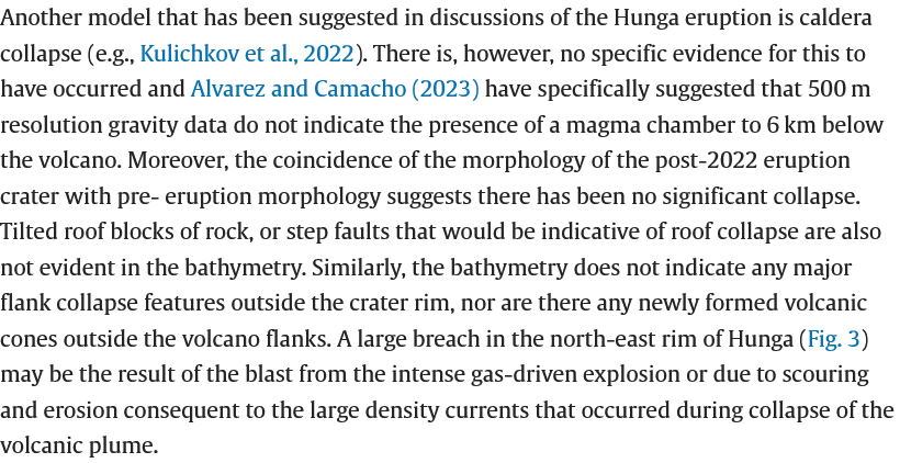
https://www2.bgs.ac.uk/vogripa/searchVOGRIPA.cfc?method=detail&id=174
I would say that the reason why there seems to be no evidence of a magma is because it was destroyed in the eruption, nearly emptied out.
I also heard mentions that the main event (2022) is a basaltic-andesite in composition. I found a paper of which states that previous eruptions are andesitic in composition.
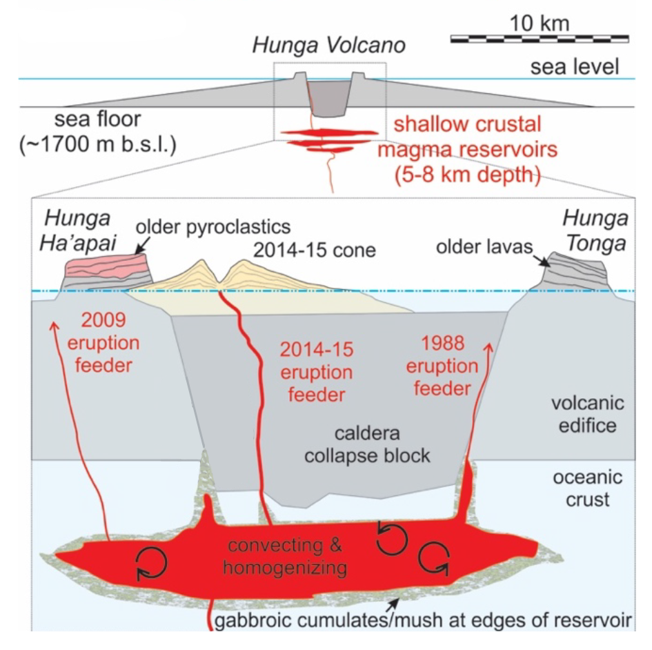
https://eartharxiv.org/repository/view/3020/
That would suggest a new influx of magma forced out the older andesite before mixing with it, probably suggesting that it had a magma chamber before.
As for the lack of terraces, they might’ve been destroyed by the explosions. Taking a look at Pinatubo, it also had no terraces after its 1991 eruption:
I might think the only time this occurs is either when it is a collapse due to lateral drainage (2018 Kīlauea) or if the caldera is very big (74,000 YO Toba), but not in small calderas.
But, dare I suggest that it could be some kind of caldera-maar hybrid (like Laacher See), where it blows up like a maar but collapses like a caldera.
Plus Hunga Tonga did throw 10 CLVD earthquakes following the eruption, these are well known to be associated to ring faults, like Kilauea, Bardarbunga, or Sierra Negra. Here are the focal mechanisms of 9 of those 10 CLVD events that emanated from Hunga Tonga:
https://www.globalcmt.org/cgi-bin/globalcmt-cgi-bin/CMT5/form?itype=ymd&yr=1976&mo=1&day=1&otype=ymd&oyr=2024&omo=4&oday=25&jyr=1976&jday=1&ojyr=1976&ojday=1&nday=1&lmw=0&umw=10&lms=0&ums=10&lmb=0&umb=10&llat=-21&ulat=-20&llon=-176&ulon=-175&lhd=0&uhd=20<s=-9999&uts=9999&lpe1=0&upe1=90&lpe2=0&upe2=90&list=0&start=59814
The collapse itself may have been frictionless due to ring dike intrusion, but over the following two months, continuing collapse seemingly employed a ring fault structure,
Yeah, then we have this one that coincides with the start of the final eruption. Notably it’s also a vertical CLVD, but with the polarity reversed compared with the ones in the following days.
https://seismicportal.eu/eventdetails.html?unid=20220115_0000243
Not sure what to make of their claims.
They present a valid model. Whether it is correct needs to be tested with data, not opinions. What predictions does this model make, and can they be confirmed? I have felt that the idea that sea water entered the magma chamber was attractive but did not explain why the explosion was so large. To add more smoke, both Krakatoa and Hunga Tonga had been erupting for a while and in both case, the climactic eruption came after one or more other large explosions (VEI 4-5 but not as large as the main event), in the case of Krakatoa in the hours leading up to the final bang, in the case of Hunga Tonga in the previous day. (By the way, calling it HHHT ignores the fact that the two islands had come together years before, and so the place should revert to its previous name of just Hunga Tonga. In my opinion.) If there was a blocked conduit, should that not have cleared in the previous explosions? I still think a flank collapse of the erupting cone played a role in the process.
Regarding the name, it could be noted that it has been split in two again, even if only a small fragment of the Ha’apai part remains. What do the locals call it?
I hope there aren’t any!
I was under the impression that the magma chamber was shallow and probably within the volcano maybe even above the surrounding seafloor. It also destroyed itself in the process so the whole volcano is basically back to square 1. HTHH seems like a young volcano as evidenced by its more mafic composition among what are more typically dacitic calderas, or volcanoes, like nearby and axtive Metis Shoal and Home Reef. It is probably very similar to Tofua and both are likely only a few tens of millennia old.
Also speaking of Tofua it seems to be more actively erupting right now, not overflowing or fountaining but there is probably an obvious visible lava lake there now if anyone went to see it.
Actually, there is quite a crazy number of massive basaltic calderas that are active right now. Ambrym erupted this week and might still be doing so. Tofua is acting up, Yasur is being normal whjch us another way of saying very active… And Ambae is apparently actually continuously active now too, there was a video I saw that didnt show lava but an intense glow over the summit cutting through the fog, it likely has a lava lake too.
So there is Ambrym, Yasur, Tofua, Ambae, Taal, and perhaps very soon to add to the list are Kilauea and Masaya. All of these except Kilauea are probably capable of a full vertical ignimbrite caldera eruption even though most eruptions are fluid lava eruptions (except Taal, which might be a bit more viscous). And Kilauea still has the ignimbrite style on occasion, it just doesnt evacuate the magma chamber that way, Pele is a lot more sneaky I guess…
To be honest I see it being way more likely that the next volcanic disaster comes from a highly active basaltic volcano that deviates from expectation, than a silicic mega complex. Imagine Kilauea has another collapse in a few years to finish the job and instead of what it did in 2018 the whole ring fault immediately falls out and the top caves in, burying the summit in surge deposits. Some of these have gone hundreds of meters up the side of Mauna Loa in the past and as far as the Pu’u O’o area. I have been at Keanakako’i and even at late hours outside park time there are thousands of people… Its not a global disaster but it would be enormous for volcanology with far reaching implications for our understanding. And that is to say nothing of the far less hypothetical danger Taal could be in the same timeframe,
Tatun makes me question how well studied the other volcanic systems of the Northern Taiwan volcanic province are given that they are more or less located in between Tatun and the historically active Guishan island.
Since Tatun itself is so often dismissed could the others also be a sleeping danger?
It appears to me that the key is a lot of wet magma (~1% H2O?). I think we would have to assume that all subducting old oceanic plates are wet, sort of by definition. Presumably the water can be lost piecemeal over long periods of time, perhaps if the slab descends slowly and so volatiles can leave for the surface slowly over a wide area. Conversely, if it descends rapidly and/or nearer vertically then H2O may well be unable to escape other than in big gobs.
I haven’t checked but I think its been said that the Tonga area is fast and near vertical.
The other place volatiles could accumulate would be if they cannot reach the surface due to overlying cratons. Then the either have to blast through or go past the edge of the craton.
Kueishantao is the one to be watched although it isn’t considered extinct. It isn’t very well studied but there is decent chance for landslide-tsunami for this volcano
Guishan island is another name for Kueishantao.
I was thinking about the Chilung group for example, similar age and setting to Tatun but information seems quite sparse other than presumed pleistocene age, which Tatun also was thought to be before young eruptions were dated.
Side tangent, Tallis, near the end of this article you mentioned a volcano csndidate called Weishan, where is that or what system does it belong to (other than presumably China or Taiwan)?
Can’t seem to find any matches when I search for that name.
Somewhat embarrassing not recognizing the alt-name for the volcano
https://pubs.geoscienceworld.org/gsa/geology/article-abstract/48/9/913/586796/Magma-recharging-beneath-the-Weishan-volcano-of?redirectedFrom=fulltext
This is Weishan or more accurately the Wudalianchi Volcanic Field.
It’s just one of those alternate ways of spelling Chinese using the Latin alphabet. Similar to how Beijing used to be spelled Peking using the older Wade-Giles method, Kueishantao is spelled Guishandao using the Pinyin method.
Wudalianchi, I see, it was the one I was wondering if it could be, but being mostly mafic cinder cones I wasn’t sure it was dangerous enough but I suppose with a city apparently built on top of it could be devastating.
https://www.popsci.com/science/laval-lake-io-moon-jupiter/
 ?auto=webp&optimize=high&width=1200
If Jesper is interested, a very smooth lava lake at Loki Patera at Io.
https://ca.news.yahoo.com/juno-reveals-smooth-glass-lava-150511065.html
And another one. This photo tells how smooth such a lava surface is:
https://s.yimg.com/ny/api/res/1.2/HxVY5EVQpWqWKUpF3DjsPA–/YXBwaWQ9aGlnaGxhbmRlcjt3PTY0MDtoPTM2MDtjZj13ZWJw/https://media.zenfs.com/en/the_weather_network_616/904ce37f3dc5ea845376270ebf08de88
Wow the lower link looks exactly like the freshly overturned lava lake surfaces at halemaumau, completely shiney in sunlight. There is lots of heat there to keep that surface free from sulfur frost and able to overturn, at 230 kilometers wide there is nothing else like Loki patera in the solar system in terms of current erupting volcanoes, making it the most thermaly powerful volcano on avarge in this entire solar system!
https://twitter.com/PCharon2000/status/1741400757767754017/photo/1 fun changes near Loki Patera! It looks like another hidden lava lake overturned between galileo and Juno visits revealing a new dark round spot, the lava lake was always there but had a colder stagnant crust at Galileo visit ( left of Loki patera ) as well a new pit crater to the north of it. The dark 2000 s basalt paheohoe lava flows near north of Loki Patera expanded before Junos visit, but now they are inactive and orange with sulfur snow. Amaterasu Patera lava lake have some new pahoehoe close to it
Well the lava lake stuff left of Loki overturned recently when voyager photographed, but now in 2023 Juno it have gotten a stagnant sulfur snowed basalt crust. Loki is always dark so its crust is likley hotter and thinner than its crust and other lava lakes like tupans
I only like mega volcanoes… so Io is the perfect place for me althrough kind of stinks its so far away but I place my eggs in basket of technology so maybe I can see more of Io later if more spaceprobes are built, sadely Io volcano eplorer, the proposed probe is not going foreward much
The most monsterious currently erupting volcanoes in the solar system! there is nothing else like this on Earth and it may never have been souch large open vents since earliest archean on earth, it makes current Sundhnúksgígaröð eruption in Iceland look like an absolute aftertought! I wants more probes to Io hopes Nasa gets intrested one day..
artist impression, me thinks?
It is indeed, based on the Nasa images in the comment below.
However, this undermines the potential wonder it has. A freezing, nearly airless climate, sulfur covers the ground where more ancient flows once lay. Then, in the distance, you could see a large expanse of smooth crust, with large hornitoes emerging from the shore, pouring lava into the lake (similar to the ice-canoes at lake Erie). I could let the rest of ya’ll paint a better picture.
Loki patera is really an insane volcano that can swallow the entire vatnajökull area in its lava lake pit, the pit walls are 2 kilometers high or more making it oversized to any volcanic features compared to earth, Io s low gravity and strong tidal heating is perfect combination to create MONSTER volcanoes with magma chambers and caldera features in oversized scale. As Albert says we are lucky that Earths avarge volcanoes are not Ionian in scale. Loki Patera is always dark unlike some other lava lake crusts on Io that develops thicker frost covered crusts and overturn less frequently, since its always dark and overturns frequently, I guess Loki Haves a very high heat input with Amaterasu and Dazhbog lava lakes being similar. the crust is likley very thin on Loki much less than a meter I guess its so smooth, perhaps as thin as the overturning crusts in the halemaumau 2020 lake. Its entirely possible that Lokis crust is very thin and is circulating and just not overturning meaning having crustal plates and glowing seams that moves around ( the spaceprobe imagerys thermal resolution is too low to read or see that for now ) but since Loki haves a relativly low thermal output per square meter.. its not a very active lava lake surface compared to Pele Patera. One can imagine small lava fountains spattering along the edges of the pit walls
Overturns of Loki takes months months to travel across that lava lake thats how huge it is
https://www.volcanocafe.org/a-quick-tour-of-volcanism-on-io/
You can read my tour on Io here: truley a world of fire and ice.. the image is a cgi rendering but other links have real photos.
https://www.volcanocafe.org/ios-pillan-patera-eruption-in-1997-the-largest-lava-falls-ever-seen/ And the 1997 eruptions lava falls on Io that woud have been a insane sight
https://twitter.com/volcanopele/status/1754298373338018014/photo/1
click on photo to enlarge
Another recent good shot of Io from Juno. Showing numerous large shield volcanoes with calderas, many of these have not been active for a few decades, their basalt flows covered in sulfur snow. A few of these shield volcanoes have dark active lava lakes at their summit calderas. Fjorgynn Fluctus have had many fissure lava eruptions since Galileo left ( the dark new basalt lava flows ) each of these ( channel feed aa ) flows are over 100 kilometers long
Some deep Pahala tremor in the ocean Southeast of Naalehu.
2024-04-26 09:25:55
Earthquake
Magnitude:2.1M
Depth:26.9mi
First the MITD plot,

Then the TRAD Plot,
Nice! I wouldn’t mind more of this. Elsewhere, the Chain of Craters has become seismically active, some interesting fracturing earthquake sequences are showing in the seismograms, and AHUP is almost as inflated as before the deflation of the February dike intrusion. Still probably more than a month away from Kilauea doing its next event, but signs of instability are starting to show up.
I have been watching ESC Tilt also up around 5 microradians in the last month. I thought I had some other deep tremor lately, but most were not as clear as this one.
Seems like the deep quakes we have been seeing could be starting to show their effects higher up. I dont think the tiltmeters are sensitive to stuff happening in the deeper major chamber the same way Mauna Loa rarely shows tilt signals. So possibly there is now magma flowing directly into the Halemaumau chamber, which can probably do an eruption much more immediately although probably brief and similar to those in 2023, basically not relieving pressure.
I had back in February or March made a prediction for another SWRZ intrusion in May, with probably a higher chance to erupt than the last one although far from certain. 1974-5 and 1982 were isolated, in both cases being taken over by flow to the east shortly after. That isnt happening now so the rifting I think will continue properly abd keep repeatedly intruding the same area as happened along the ERZ in the 60s, which ultimately created a more permanant vent. There is no Mauna Ulu or Pu’u O’o on the SWRZ but then there was also just one comparable eruption on the ERZ too within several millennia up to 1969. Maybe expecting the next persistent vent/shield to be on the SWRZ connector isnt so foolish, Kilauea has clearly changed somewhat in the past century in terms of behavior that is clear, Pele has probably got some surprises 🙂
It us also somewhat evident in the cross caldera GPS that magma is moving to the southwest too or at least up to the last data point. Strong upward trend that then levelled off at the end the same as after September when all this started.
Added to this the intruded magma in SWRZ is still there. If a relative small amount of magma enters this stored magma, it can have a big effect. There may be f.e. a situation with first a summit eruption and then a small intrusion in SWRZ with the onset of an eruption there.
How active was the summit around 1823, when SWRZ had the big show?
Well William Ellis and his party didnt see Kilauea before the Keaiwa flow, and the 1794 Vancouver expedition saw Kilauea with a deep empty caldera from Mauna Loa. I presume it would have looked like the current lake/floor and that is also what it looked like at other observations post-1823 but the amount of tephra younger than the 1790 deposits do make me wonder if the filling before 1823 was more like at Kilauea Iki in 1959 but bigger, with intense eruptions of large volume and short duration. There are the two reticulite fallout deposits that were formed this time and were made by estimated 500-1000 meter fountains in the south caldera area, where Halemaumau would eventually focus. 1959 erupted 2 million m3 of reticulite and cumulatively about 60 million m3 kf lava which only part didnt drain. Both the Golden and Eastern pumice are 10 million m3 each, so theoretically each was probably associated with singular eruptions of 0.3-0.4 km3 of lava, which if erupted today would by themselves fill the 2018 caldera…
I imagine such eruptions only happened because the deep pit was enormous and erupting into it to fill it was easier, same as why in 2020 that eruption filled up 150 meters in a few days then nearly died immediately after it buried the vent. Imagine that but with a 1 km tall megafountain and the entire caldera to below Volcano House being a glowing lake, and that it did this at least twice too. If the shallow chamber was completely destroyed in 1790 then gas rich magma from the deeper parts of the plumbing would erupt directly, explaining the extreme fountaining atypical in Hawaii, such an eruption probably cant happen at the summit today now it has a massive homogeneous and relatively degassed magma chamber.
One other thing about 1823 is that the volume of the current lake probably isnt large enough to break open a dike low enough to reach the Great Crack or similar. It probably is low enough that a rootless dike from the lava lake could still erupt out in the SWRZ but ut would be a small lavashield like Mauna Iki not a lava flood. Much more grand things may be in store for the SWRZ proper, erupting out of the connector.
The “frozen” lava lake is still a passive one. A dynamic open lava lake with connection to the magma chamber would be more able to push into SWRZ like 1919-1920.
The lava lake doesnt need to be active just deep enough to have the pressure to force itself into the cracks in the wall. The lava in Alae crater in 1969 did drain out exactly this way without a vent in the crater at that time. The lava lake in the 1820s would have been mostly rootless too, it can still have an active vent in it, just like the current one did in 2022, and still be rootless. It just means the lake doesnt completely sit inside the vent conduit like the one in 2018 did.
HVO also finally made this public, the data for the KOSM GPS, on the SWRZ.
Basically I think it is now pretty obviously confirmed that magma flow into the SWRZ is very significant and also resumed immediately after the intrusion and at high intensity. The station has been pushed west by 10 cm and up nearly 15 cm in only 2 months.
Thank-you for the graph and interpretation! This looks as if the SWRZ has an independent inflow of magma. But I believe that we have to wait some time. Summit eruptions are easier now.
The map with quakes shows that middle deep earthquakes happened below Kilauea Caldera and the Highway, but that the shallow earthquakes occured to the south of Kilauea Caldera:
The three eruptions 2023 and the intrusion January/February 2024 had an increasing tendency of the intrusion/eruption rate. The eruptions 2023 had nearly the same volume (0.016-0.019 km³), but a rapidly decreasing duration:
1. 61 days, 2. 12 days, 3. 6 days
We’ll have to find out whether Kilauea continues this tendency towards short, but energetic eruptions.
September eruption was really quite extraordinary. Its pretty easy to miss that it was nearly as intense as the fissures at Svartsengi and only looked small by being trapped within the caldera. The caldera is also way bigger in person than it looks in pictures.
I would imagine if the next event is another SWRZ intrusion that successfully erupts, the eruption would be very like the Svartsengi fissures. The lava will probably also flow very fast and a long way even if the eruption is brief. Definitely dont want to be downslope…
One of your aces just stirred. 3.9 at Campi Flegrei?
Yes. See or listen at:
https://www.napolitoday.it/cronaca/scosse-terremoto-napoli-campi-flegrei-27-aprile.html
https://www.napolitoday.it/cronaca/campi-flegrei-servizio-radio-francese-france-inter.html
(good for practicing one’s Italian…)
E anche il Vesuvio:
https://www.napolitoday.it/cronaca/terremoto-vesuvio-oggi-28-aprile-2024.html
Alert level raised to yellow at Puyehue-Cordón Caulle volcano.
https://www.elmostrador.cl/noticias/pais/2024/04/26/decretan-alerta-amarilla-en-complejo-volcanico-puyehue-cordon-caulle-por-actividad-anomala/
https://rnvv.sernageomin.cl/complejo-volcanico-puyehue-cordon-caulle/
I wonder if Puyehue Cordon Caulle is a potential mahor caldera in the making. Its bimodal mostly rhyolitic, and it erupts what might be the least viscous rhyolite of any volcano, it looks almost like thick basalt in the 1960 flows. 2011 was stickier but still quite mobile. Presumably the lava is very hot for its composition, probably 900 C or more, and likely almost completely obsidian being so dark coloured.
The eruptions are fissures but there is an old large caldera in the complex, and hot crystal poor evolved magma is a megacaldera characteristic. So are large eruptions without collapse, 2011 was over 1 km3 of magma although the tephra volume probably was not quite a VEI 5 as often claimed. I
ts nearly as much as Holuhraun and Kilauea which both initiated collapses at magma chambers of tens of km3 volumes after only a few % drainage yet nothing of such occurred at PCC… I mean, it is worth investigating at least, there might be a couple hundred km3 of hot rhyolite down there ready for the right trigger.
Lava has breached Grindavik berm
The Icelandic authorities seem to be quite relaxed about it:
„Þetta er lítið hraun sem er bara að rúlla yfir garðinn, kalt hraun þannig lagað sem er að ýtast yfir. Þannig að þetta er algjörlega minni háttar og við höfum ekki áhyggjur af þessu núna.“
This is a little lava that’s rolling over the protective wall, cold lava that’s spilling over. Since it’s absolutely minor, we’re not worried about it right now.
Not major as of yet
But one or two glowing bits of lava in it.
What’s between it and the ocean?
Grindavík…
Thought most of Grindavík was to the west of that point?
And the police is there to make sure it does not cross the road. That worked well in Fagra I: lava never crossed the yellow tape.
As for the berm: overtopping lava will make it even higher.
https://www.youtube.com/watch?v=wiRdr5LzbwY is another good example of lava toeing the line.
Now that the inflation at Svartsengi seems to be back at almost full speed, quake activity has also returned to the Sundhnúkar dyke. Not only that, but if you go to skjalftalisa.vedur.is, it is possible to outline an area of interest (veljið svæði á korti). If you select a narrow area containing only the active part of the Sundhnúkar dyke, get all quakes since December, then navigate to the plot page, an interesting pattern appears. Before each eruption, and the March dyke intrusion that didn’t erupt, there has been a clear gradual uptick in the quake activity – something that is also seen right now. Comparing the current activity with the activities that lead up to the February eruption and the March intrusion, it seems like it might only be something like 7-10 days before something new will happen. Exactly what that will be remains to be seen. I’m personally betting on new fissures and new curtains of fire.
I’m a little afraid that any Darwin award candidates in the area when that happens might just turn into “winners”. For that reason, I hope I’m wrong.
Up until now, the seismic activity has dropped after the initial uptick …. then there is a swarm very shortly before an eruption starts.
The authorities are advising that no-one visits the area on foot.
If you do like I said and then look at the cumulative seismic moment curve, day by day, it’s almost completely convex between events. It starts slow, then increases at an increasing rate over the last 10 something days before the next event. There’s no doubt that it has started picking up again. Unless something changes, something is bound to happen very soon.
Last night there were 3 people (with headlamps) wandering around the field, one very close to the cone. A bit later the Coast Guard helicopter came over, probably on a report. This was around the 10 pm to 11 pm hour.
The latest looks fairly gradual.
Also note that the graph shown here is the total number of quakes. A tiny M0.5 will count the same as an M3. The third graph on that page, not shown in your screenshot, is the seismic moment, which is more representative of the actual tension in the area, but which can also be thrown off the scale if a really large quake happens.
Thank you Tomas, for mentioning the missing 3rd graph. I did some displays with some different settings, but the March 4 – April 27 2024 setting shows best what you are pointing out on the convex rise. 195 quakes are captured in this period.
Do the quakes indicate that the intrusion is moving NE from the present eruption location?
The current vent is at the southern end of the fissure that opened in March. The recent quake activity is under what was the central part of that fissure. This is a likely place to rupture again if we do get a new curtain of fire. The current vent may or may not take part in any such new activity. I’m not sure if that would qualify as moving NE.
This would likely be a harmless location for an eruption to avoid harm for Grindavik. The old lava field “Dalahraun” shows that there was a center of activity before.
Earthquakes since 16th March 2024 to date with a max depth of 3km.
The earthquakes to the NW of Grindavīk are interesting. They are very shallow but spread out a bit.
Other graphs for completeness for the same criteria (quakes since 16th March 2024 and max depth 3km)
It will be interesting to watch the behaviour of the currently erupting cone. The last videos (here one of “Just Icelandic”) show that there is a small lava lake in the crater of the cone. It may react to changing magmatic pressure in the deeper system:
https://www.youtube.com/watch?v=iIUabC9G_0s
Do you expect this eruption to continue in the case that a new vent opens?
Don’t know what it will do 😀
Guess it depends on where and by what route it is getting its magma from.
I didn’t include that little cluster, since it’s not part of the dyke. The N-S orientation hints that it could be movement along one of the tectonic faults that shifted right before the start of the November dyke.
It’s difficult to know from the map above. The quakes at the SE tip of the cluster may be related to the dyke / graben as they are on the same line. But that could be coincidence.
It’s now ~40 days since the beginning of the eruption of 16-18th March. Nearly double timespan compared to the 20 days of dormant phases between the first episodes. It looks as if the ongoing small rate eruption reduces the reloading of the magmatic system with roughly 50%.
https://www.windy.com/sv/-Meny/menu?tcso2,2024042700,11.329,41.572,5
Lots of sulfur in Africa now.. maybe Virunga have a vigorous eruption, open vent in Nyiragongo / Nyiramuragira that are both very gas rich high potassic volcanoes. Its war in the region so not heard alot from the news
Thanks for showing us this Jesper, really interesting use of the website.
Many of the red areas coincide with volcanic areas, but the huge spotch of red in the indian ocean and Somalia is puzzling to me..
I took a look at my diary today, and saw that I had written in, “Grindavik Erupts!”
That was from our speculations a few months ago. Any guesses for a new forthcoming date?
During the night we can watch the “firestorm” inside the crater with disturbance of the Fumaroles by the lava heat: https://www.youtube.com/watch?v=FZmN2daZW9g
I think Kilauea might have just had an inyrusion, nearly 400 quakes in a few hours. Its not like the one 2 months ago but way higher than the standard quakes even when the rift connectors are pressurized. It seems like it could have been under Pauahi and Hi’iaka craters too which I never expected.
How deep is the source for the magma? Should we expect normal magma or higher “primitive” Magnesium conent?
Well, I would have thought a highly magnesian magma up until recently, but not now. The lava erupted in September last year was basically identical to the Pu’u O’o lava after 2011 which has been homogeneous at about 6.5% MgO or something like that. Kilauea since 2011 I think has basically created a large volume single magma chamber that partly drained in 2018 but is still mostly intact, fissure 8 was not low enough to fully collapse it.
So probably the lava will be similar to this regardless of where it erupts, although the intensity and duration could be variable. The upper ERZ connector swarm is in an area that hasnt erupted in centuries so if it does break that trend now it probably wont be anything impressive apart from visually, maybe like those in 1968 or 1979. A SWRZ eruption now could be at a low elevation at 700 meters so could be significant.
Sometimes Kilauea does magma intrusions, that are independent from the main Halema’uma’u magma system. F.e. Kilauea Iki 1959 (Summit eruption), Mauna Ulu and Pu’u O’o. Most summit eruptions are driven by the main system that also can influence rift zone eruptions, f.e. the Leilani Estates eruption 2018.
So I was thinking whether the current inflow happens in the Halema’uma’u magmatic system or in an independent system.
Halemaumau only feeds eruptions in the caldera or along the western side of the SWRZ (on maps as ‘volcanic SWRZ). Kilauea Iki really just seems like it is sitting alone, its a satellite volcano in some ways although also definitely connected to the caldera. The ERZ is entirely fed by the ERZ connector and maybe a small amount from deep intrusions, and is completely separate at a shallow level to Halemaumau. The same for the SWRZ, the connector is on maps as ‘seismic SWRZ’, and as we saw in February it has intrusions that dont start in the caldera too.
The permanent magma system that most eruptions happen from is the summit caldera complex and the two rift connectors. The summit complex seems to be a massive chamber that is about the same dimensions as the caldera but maybe offset from it. Above that is Halemaumau, and to be honest the boundary usnt clear but it does exist. Kilauea Iki is maybe an offshoot of the deeper chamber, it doesnt look like it has an actual chamber but it is polygenetic. The rift connectors are permanent to the point where they bend, and how far they go past that seems to be based on a combination of pressure at the summit and south flank extension. To be honest if the ongoing activity means the ERZ is now getting ready then it could get pretty dangerous, the south flank has been moving ever since 2018 and no magma has flowed in now for several years so there is ample room to let magma immediately flow very far along.
1974 was a year when during the last days of Mauna Ulu the activity began to shift from ERZ towards SWRZ, maybe a development which is possible again. 1974 they observed:
” the magma storage areas migrated westward beneath the summit region in 1974: from the upper ERZ, to the area between the uppermost east rift zone and Halemaumau (July), to Halema’uma’u and the west (September), then into an area between the western KFS and the upper SWRZ (December), with subsequent intrusion into an area south and southeast of the SWRZ (early January).”
https://pubs.usgs.gov/pp/1613/report.pdf
They discussed that a SWRZ eruption 1974 was prohibited by Mauna Loa’s expansion. 1974 the three eruptions migrated from east to west. July eastern summit, September western summit, December between SWRZ and Koa’e Fault. 2024 Mauna Loa is sleeping. So it’s possible that if the pattern of 1971 and 1974 is repeated, the SWRZ should be open for eruptions.
The SWRZ did erupt in 1974… The affect from Mauna Loa was referring to the part that erupted in 1971 extending from Halemaumau, which is not connected to the SWRZ connector. This part is literally a crack in the side of the caldera, the eruptions from it (1919, 1823 etc) are usually lava from within the visible lava lakes in Halemaumau that pushes into the cracks and flow down, really not all that different to when the lava in 2014 flowed into an ERZ crack and then flowed out of it again several km further down and far beyond the surface flow front. its also what happened at Pu’u O’o in 1986 and 2007 when flank vents opened a few km to its east. In 1971 there was a fissure eruption in Halemaumau that took advantage of the same crack, although because the magma was not from a lake this time the eruption had fountains instead of just leaking out of the ground.
Its not impossible for this to happen now but its not really obvious what actually makes it happen, the most likely case is pressure at the lake bottom. Which is largely unrelated to magma movement in the connectors or magma chambers, just on how much magma is in the caldera, which obviously requires a summit eruption. It could be a secondary affect of an intrusion elsewhere though which would make it related to other activity.
I dont think the 20th century activity is a good model, because the caldera now is deeper. Eruptions were so common in the Chain of Craters area in the 60s-70s because both the floor of Halemaumau and then the open vent of Mauna Ulu were over 1000 meters elevation. When the 1975 quake happened it opened up the ERZ much lower, so magma subsided and flowed down it and all of this activity ended. There were some small eruptions up high in the early 80s but as soon as the rift refilled it created Pu’u O’o which was much further east and lower. It wasnt until the 2010s that magma pressure was able to erupt above 1000 meters elevation again when the lava lake overflowed in 2015 and 2018, and then it all drained out again after a few years of course. Pu’u O’o basically dominated the ERZ for its active years, there were very few intrusions that didnt involve it directly between 1983 and 2018.
Todays situation really is a bit unlike anything obviously in the historical record though. The ERZ dominated activity of 1954-2018 was alongside a nearly full caldera. But the century before 1955 also saw a mostly full caldera but few flank eruptions of any sort, yet one massive one far down offshore. And the first half of the 19th century had a mostly deep caldera that filled and drained with lava lakes several times, with both rifts active and both rifts doing a huge lava flood… Today is really kind of like all of these, a deep caldera that has filled very fast, but without the volume needed to spontaneously drain. At the same time the rifts are both active, but only one of them is actually getting fed magma. And the caldera floor at this exact moment is right in the gray zone of elevation where it is probably equally possible to get a summit eruption or a rift intrusion with the same pressure. The fact the whole south flank and Koae is highly mobile right now only complicates things even more…
It’s true, Kilauea changes its face and behaviour a lot from time to time. The centuries before 1800 had a broad variety of eruption types from Plinians to enduring shield eruptions and everything in between. There was a “chapter” from 1790 to 2018 which had its known historical timetable, but we don’t know how the new chapter, that began 2018 will continue.
Even the 2008-2018 lava lake was different to the 19th century lava lakes with their big surface.
The eruptions 1971 and 1974 looked like a pattern of a behaviour, that would be nice as a model, but as you described, there were unique circumstances.
Intrusion under Kokoolau crater seems likely. Its not a long dike, but also doesnt seem to be over, and this crater is a spatter cone and not a collapse pit crater like the others.
This area is about 200 meters higher up than the floor of Halemaumau so an eruption here would probably be pretty short but if the magma is gas rich it might do it. The lava in September though did look extremely frothy, the magma chamber might be homogeneous but it seems like the degassing from the overlook lake was all drained in 2018, maybe my assumption we cant get high fountaining right now is very incorrect…
Yesterday, I wondered if an intrusion could be going on, but I didn’t see anything too obvious. At best, there are some micro-intrusions in the Kokoolau area embedded within a major recharge episode. An intrusion would produce a very localized flurry of earthquakes of a up to a few per minute. Looks more like a supply surge that is affecting both the upper rift zones with perhaps some related micro-intrusions, particularly yesterday. The SWRZ tilt is shooting up faster than before, at this rate it might not be long before something breaks. That said, right now, an eruption is probably only possible inside the deep caldera or from very low elevations in the rift zones. Kilauea is no more inflated than when it did the non-eruptive dike of February.
Also interesting is that only the uppermost SWRZ is showing activity. Another very interesting detail is that the ERZ is only seismically active over a short section. The Keanakakoi-Puhimau bit is completely silent. There must be a good reason for that. It has been like this for over a year.
I did wonder at first if this patch was a response to the SWRZ moving, both connectors border the Koae faults and the whole area is very mobile. That might still be the case anyway but the activity now is clearly also local in origin too, although none of the stations nearby show any particular deviation that would be expected if a dike was about to run. It might be worth noting that if the Pu’u Koae rift area is continued through the Koae fault zone it does end up basically at Kokoolau crater and where the quakes are concentrated.
The complete lack of response from the UWEV tiltmeter is also very interesting, it is just coming out of a DI event but no sudden spike in inflation. To me that probably says at this point forcing magma into Halemaumau is harder than going into the rift connectors. I wouldnt bet on a caldera eruption, the next event will probably be an intrusion again. I think if it happens in the same place as last time though an eruption is much more likely, given the last dike was close enough to cause surface cracking there probably isnt much space left to keep it all underground.
Only wildcard though is that if Halemaumau does get involved things move extremely fast, if the pressure connects to its magma chamber then a dike and eruption will probably form within a few hours and with no obvious indicator before that happens.
Theres a lot of movement at this sensor.
 ?fileTS=1714384785
That might be a quake signal, too early to tell yet though. There was a particularly lively set of quakes just recently.
If the pattern of 1971 and 1974 is going to repeated, we will get:
1. An eruption close to the Chain of Craters Road
2. An eruption on the West Rim of the Caldera
3. A purely SWRZ eruption, which 1974 was prohibited by Mauna Loa’s interruption.
If we look at the September 2023 eruption and the January/February SWRZ intrusion, we see a similar trend from East to West around the summit in some cases. The 9/2023 eruption happened in the eastern part of the caldera, it was not very far away from the Keneakoki Crater:
https://www.usgs.gov/maps/september-14-2023-kilauea-summit-eruption-reference-map
Maybe a possible explanation why the new swarm has appeared so suddenly while at Keanakako’i it is still quiet is because Keanakako’i is now sitting above the magma chamber itself, as in the south caldera reservoir/major chamber has expanded outwards to the southernmost caldera fault. So basically now the ERZ connector starts at about where the new swarm is and Keanakako’i/Puhimau is firmly within the summit realm now as opposed to being an overlap zone.
Keanakako’i and Puhimau have always reacted to summit inflation in recent years in a nearly identical way to the more obvious south caldera and SWRZ stations, even while DEVL only a few km away shows only weak reaction. The same is true at Kilauea Iki too which is the northern end of this exterior caldera fault block. If this is true then a major caldera collapse could well be in the near future, 2018 was Halemaumau collapsing but the deeper chamber was not damaged nor were the rift connectors. It also probably means the sort of frequent small intense summit eruptions of tge 20th century might not occur further, future caldera eruptions will be under pressure and probably large and voluminous, though likely still short. A bit like those of Mauna Koa in some ways but ring fault focused.
At this rate, I’m guessing that when it breaks, it could be a non-eruptive Kokoolau dike, a non-eruptive or eruptive dike in the south caldera rim area, or an eruptive dike within Halema’uma’u.
Today many Magnitude 2 quakes accumulate around the PUHR GPS station somewhere between Keanakako’i and Hi’aka crater. It looks as if we should expect either an eruption like 7/1971 (both inside Kilauea Caldera and the area of Keanakako’i Crater and Chain of Craters Road) or 8/1968 and 5/1973 (in or close to Hi’aka crater)
Earthquakes number of Kilauea already exceeds 400 today:
Here the National Park shows one of the craters along the Chain of Craters Road: Pauhahi Crater, where eruptions occured May 1973, November 1973, and November 1979.
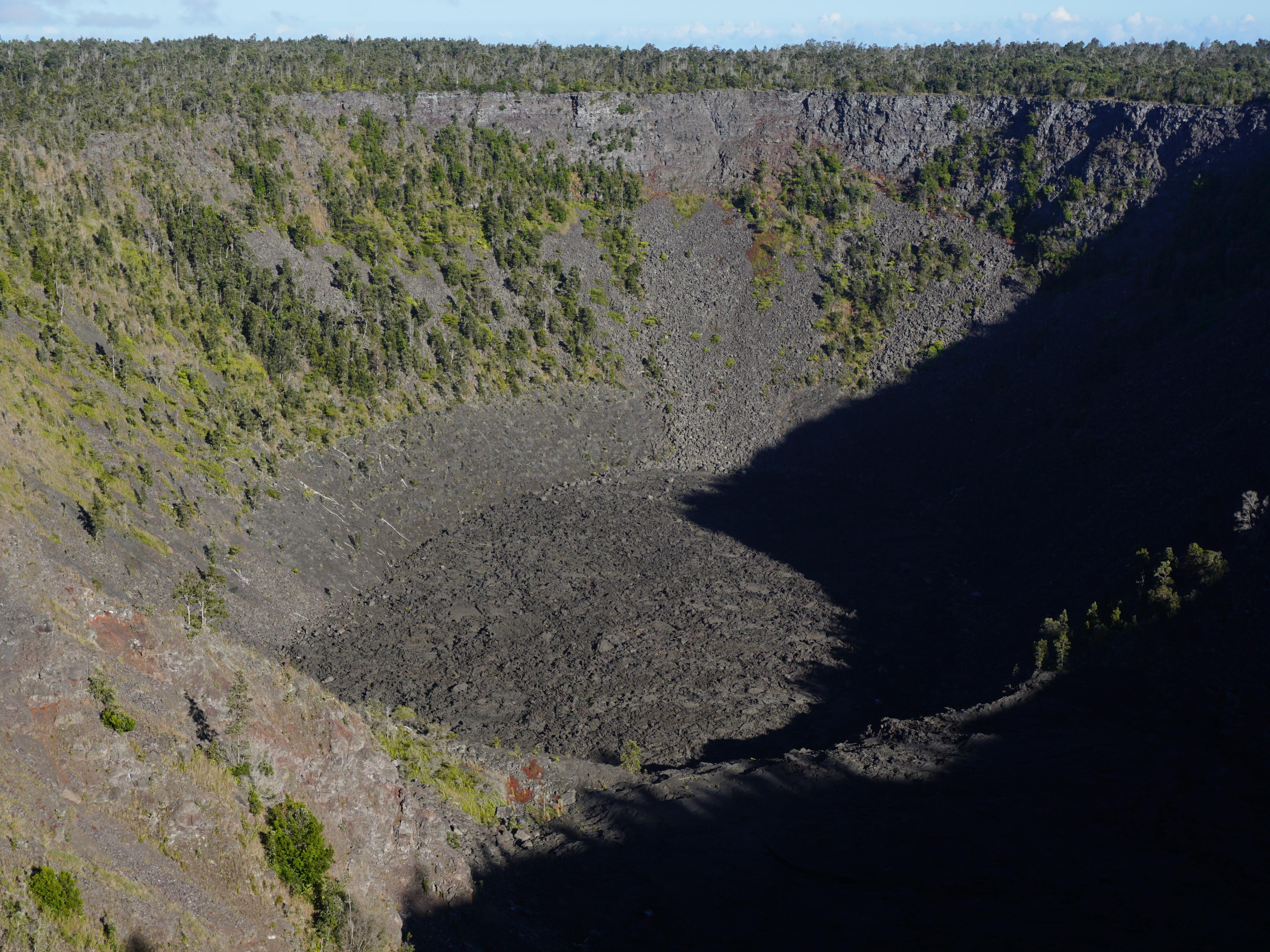 ?maxwidth=200&quality=90
https://www.nps.gov/places/pauahi-crater.htm
Small photo:
Quick question just to be sure if I am not mistaken. Can’t background subsidence weaken or negate uplift? For instance, if magma is leaving a large chamber, producing 3 cm/year of deflation and the magma flows into a smaller chamber within the same area producing 6 cm of inflation. Wouldn’t the “true uplift” be 9 cm since the uplift has to counter the 3 cm of deflation in the background?
And yes, this question relates to Chiles-Cerro Negro.
Only if the area magma is moving into is also subsiding.
If magma movement alone is causing the deflation round about, there might not be any deflation, or as much, in the area that magma is into – most likely, it’ll just inflate.
I looked at some updated Insar data for CCN from the COMET database and I am confused. For almost the entirety of the last 10 years, Chiles-Cerro Negro and Potrerillos have been surrounded by a ring of subsidence with peak speeds of around 4 cm/year. I didn’t think too much of it but now it looks like the trend has somehow reversed itself in some areas since mid-2023 and areas east of the volcano are starting to see uplift.
In conjunction with this, the rate of uplift has doubled in Potrerillos while it weakened at the Chiles cone. How could this happen? is the coherence too bad for an accurate reading?
https://comet.nerc.ac.uk/comet-volcano-portal/volcano-index/South%20America/Colombia-Ecuador/Chiles-Cerro%20Negro/S1_analysis
I knew that the alert was raised at Puyehue-Cordon Caulle but I didn’t know the activity was so impressive. One of magma chambers is inflating rapidly with a peak speed reaching 2.4 cm/month and cumulative uplift has reached 42 cm, 3 km away from the most intense area. I don’t know if this is from a shallow chamber or it’s much deeper and larger chamber. I just want to say that the eruption in 2011 was preceded by 30 cm of uplift…
Its a very interesting volcano. Its a rifting rhyolite volcano with two calderas. It is a large system. But due to its structure a large earthquake can weaken the faults above the volcano and trigger an eruption like in 1960.
https://www.researchgate.net/publication/249527452_Eruptive_history_geochronology_and_magmatic_evolution_of_the_Puyehue-Cordon_Caulle_volcanic_complex_Chile
https://se.copernicus.org/articles/14/69/2023/
https://agupubs.onlinelibrary.wiley.com/doi/10.1002/2016GL070066
The volcano has risen over 1.3 m in the last 13 years, It might overcome the 1.5+ m co-eruptive subsidence in next 5 years or so. Looks like it could be a fun volcano to track.
We have second paroxysm at Ruang!
https://zoom.earth/maps/satellite/#view=2.246128,125.1947,9z
I was kinda skeptical at first (I.e. a growing isolated storm of some sort), but after tracking the overshoot area over an hour (which is in the same spot every time), it seems a new powerful paroxysm has begun.
Looks eruption cloud is expanding at about 50km per hour, and winds are pushing everything west at about half that rate. Its growing a bit faster, but not enormously so, than the eruption cloud two weeks ago did.
That being said, this eruption is definitely bigger than that one at least in terms of the eruption cloud. The one on the 17th reached about 130km in diameter. This is closer to 190km. Though interestingly the cloud tops are a tad warmer this time, peak values -93 instead of -96.
Another VEI 4 in its own right, combined with the last one it might push the entire eruption over the VEI 5 boundary and maybe over 1 Tg of SO2
Impressive. I guess this shows you can not lower your guard with a volcano.
It seems to start around 18:50 UTC. It will soon make 3 hours of eruption which is longer than the previous one (2 hours), maybe that’s why the cloud is larger.
AIRES
@airesEO
#Ruang Some (prelim.) analyses. Q~4-5×10^9 m^3/s (2x larger than 17.04.24 eruption). 4<VEI<5. Red: 200 K contour; White dot: min Temp., Black dot: center of enclosing circle corresponding to red contour. Himawari-9 data courtesy JMA/JAXA. @simoncarn
@ThomasJAubry
@JAXA_en
https://twitter.com/airesEO/status/1785106680956731638
New post is up! The 70-year itch of Anak Krakatau
https://www.volcanocafe.org/the-collapse-of-anak-krakatau/