Volcanic tremor pulse started near Keilir at 14.20 local time. Eruption not confirmed yet. Scientific flight underway.

Keilir, this is the area that has possibly erupted. Do note that the mountain is not a central volcano, this is a fissure volcano and the entire area is the volcano. Image from Wikimedia Commons.
The quote is the official Stonetablet by IMO, translation to English by the author.
The colour code has been upgraded to Orange, please be advised. The area near Keilir is being evacuated due to the volcanic tremor pulse.

The tremor pulse is clearly visible here, and on all other station in Iceland. Image by the Icelandic Met Office.
It still remains to be seen if the eruption i prognosticated a few days ago has started, or if it is still in the making. The article will be updated as more information is coming.
If the eruption occurs at the most likely spot it will be known as either Þráinsskjaldarhraun or Þráins Fires (depending upon if there will be one or several eruptions.
We will shortly start to add links to webcams and other sources.
CARL REHNBERG
Update: Almannavarnadeild ríkislögreglustjóra is reporting that they have not seen any eruption during the eruption, but that they are expecting the eruption to start within hours to days. Visiting the area is not advised due to bad weather.
Bonus fact Update: 7 years ago I kissed a vent at Litli Trutur (the spot of the possible eruption) from the inside. I guess I should not have done that. All photographs by Nick Small.

Road of The Volcano Kisser.

Walk of The Volcano Kisser.

The Volcano Kisser in action.

The Volcano Kisser delivers a hot and steamy volcanic schnogg.


http://www.ct.ingv.it/index.php/monitoraggio-e-sorveglianza/segnali-in-tempo-reale/video-sorveglianza-vulcanica-etna
Etna is erupting again
Etna erupting again webcams here: http://www.ct.ingv.it/index.php/monitoraggio-e-sorveglianza/segnali-in-tempo-reale/video-sorveglianza-vulcanica-etna
content://com.android.chrome.FileProvider/images/screenshot/16148466211092107754707.jpg
I hope this isnt an updating image…
We are now witnessing a world record fountain, 2 km tall and counting… 🙂
Really the only reason this isnt a full blown plinian eruption is because there is a lava flow. Really blurring the line between hawaiian and plinian eruptions here.
Maybe we are looking at the wrong volcano
I think that the two things differentiating these Etna fire fountains and classic plinian events are eruption rate and grain size. If I had to guess, the mass flux rate of the fire fountains at Etna are probably of the order of 1,000 tons per second or 10^6 kg/s. Plinian events are usually 10-100 times (rarely 1000) times more intense. The grain size is another possible factor. I suspect the the spatter or “spray” in the fire fountain is mostly larger than 1 mm with much of it centimeter size or larger. By contrast, many classic silicic plinian eruptions have 80% or more by weight grains finer than 1 mm, with as much as 50% as fine as 63 microns. Still, it may be possible for fire fountains to cross over into plinian territory. I have read about deposits of basaltic scoria fall with plinian like dispersal, and densely welded or even reomorphic lava-like scoriaceous basaltic ignimbrites, and these seem to me good candidates for the types of deposit that might result from extremely high flux basaltic fire-fountains.
Etna is pumping it out currently,,, https://www.facebook.com/localteamtv/videos/424525015278172
There were a number of comments in the waiting room this morning. If you felt rejected, here is our blurb, as an explanation
As a general reminder, if you submit a comment and it does not seem to appear, the most likely cause is that our resident demon has put it in the waiting room, also know as the ‘dungeon’ by those who know. Please have patience and a cookie. One of the admins will occasionally look in the dungeon and release the occupants.
This most often happens to first-time commenters (and regretfully some caution is needed or you would be swamped with commercials in comment-clothing). It may also happen if you include links to sites which our demon views as suspicious (the demon holds a narrow view on what counts as non-suspicious), if you send in too many comments in a short period, or if the demon just feels like it. Quite a volcanic temperament, our demon.
If you are worried about being in our user database, our policy how we use your data can be found in https://www.volcanocafe.org/volcanocafe-and-the-gdpr/
Thanks for all the hard work behind the scenes, Albert. Must be busy at times like this. Andrew
And not forgetting all the other dragons, too. (Don’t want any fiery breath on me, lest I find myself consigned to the dungeon!)
We do have an oublier for serious cases..
Wow! Didn’t know about that, though now you mention it, I can think of one or two erstwhile frequenters of the Cafe who we haven’t heard from for a while…
https://m.youtube.com/watch?v=5YgYdv8ZkHQ
Super HD live from Etnas eruption
Quite a swarm in Hawai’i, both Pahala and Mauna Loa.
Sometimes I imagines the fissure intrusion to cut right through Keilir jets of lava fountains blasts through the hill
If Reykjanes erupts.. How fluid will the magma be? Will it be like Krafla? or even Kilaueas ERZ? Reykjanes comes directly from mantle decompression.. so perhaps quite hot?
But Iceland plume is not in this arera
So perhaps not as hot as Hawaii and Holuhraun can be
Will be probably very similar to Krafla so yes pahoehoe lava channels and hot lava. The mantle isnt as hot here as it is under Hawaii or Vatnajokull but this magma will have gone from the mantle to the surface in a week, so that probably wont matter. I guess there is still the case this doesnt erupt, but that is looking unlikely now.
All of this stuff happening in the one single month of this last 6 years that I dont have access to a desktop computer 🙁
Another M4+ near Keilir just now. That makes 3 since midnight
When will the dyke breach the surface ?
@Vedurstofan
A magnitude 4.5 earthquake was measured at 08:54 at Fagradalsfjall. The quake was felt in the southwest corner of the country. Unrest has not resumed in conjunction with the quake.
This is the largest earthquake since March 2 at 03:05 which was 4.6 in size.
well that was a lovely show on Etna….. forgot about the 3 feet of snow in my yard…. With so much volcano stuff going on i feel embarassed not to have Redoubt acting up… but it is soooo messy when it goes i should be very happy to have it quiet. Thanks for being such a lovely group. Best!motsfo
Impressive wasn’t it. I love Etna. Very overseeable eruptions. 😄
Just sitting and leaning back to enjoy the show. Knowing you can do some shopping and walk the dog in the afternoon, without that annoying feeling you miss important action, lol!
And it even changes showtime a bit, so every continent is able to watch at ‘normal’ hours.
The ideal volcano!
It is indeed ‘The Greatest Show on Earth” as Boris would say.
It was gorgeous, the power of creation. Just amazing.
I hates this loong wait for an eruption….at the penninsula..
Where is the eruption? wheeere isss it? its ouurs it isss …and wee waaants itt!!!!!!!
Another livestream
With all these cameras, I think the eruption is getting shy now and won’t come out while we’re all looking.
Is that just wind noise? it sounds deeper and boomier….
It’s the eruption – just behind the camera! 🙂
Only kidding.
There’s a reason the are no trees in Iceland. Actually, I think this is a calm day by local standards, only blowing 12kt at the airport.
https://tgftp.nws.noaa.gov/weather/current/BIKF.html
The lack of trees in the view makes it look calmer, nothing waving about except the grass.
There were many trees on Iceland before the humans arrived and cut all down…
Thanks for this one! I must now refrain from sitting here watching a foggy Icelandic hill all day. 🙂
I would say fog is the word of the day…the one cloud, the lowest is sitting since hours on the same place…
Is the magma drying his way up at this place? A lot of water, a lot of heat which has to move from magma to the water and slows down the “show”…
Wasn’t there a village or was it a harbour wich was saved with water from the lave?!?
https://www.ruv.is/frett/2021/03/03/beint-vefstreymi-af-skjalftasvaedinu-vogastapi
https://www.volcanocafe.org/the-heimaey-story/
It happens…. 🙂
I guess down there is only groundwater or do you have permafrost below the surface so much south in Iceland?
The guys wondering around there ought to be wearing high viz clothing, just in case …
Can seismic activity in one location trigger activity in another nearby by. For instance, can an eruption at Fagradalsfjall trigger Grimsvoten?
Grímsvötn is not nearby, so it won’t be affected (although it is primed for eruption, so it could go off, but that would be unrelated to what’s happening at Reykjanes). The entire Reykjanes area will be affected by the current rifting and there is a real possibility that we might get a long lasting sequence of short lived eruptions from all volcanic centers in the area.
Dan Manns on Twitter: “News from #Reykjanes. Tremor still ongoing, some larger earthquakes overnight, largest mag 4.5 at 08:54 this morning. Epicentres moving slightly to the SW, closer to Fagradalsfjall. I would speculate that we may see a new lava flow inundation model as a result of this.” / Twitter
I don’t think its gonna happen
@ 11.56 Just saw a car drive past the camera on Andrew’s Vimeo link ….
(follower since before VC was started in 2010, but never post as I am not volcano knowledgeable enough to contribute!)
A shame the swarm is too far away from Hengill. That would trigger me big time… 🙂
If past behaviour is a guide, than the re-activation of the peninsula will very quickly move east, towards Hengil, and later on expand westward. ‘Very quickly’ means in the next century or so.. Stay tuned.
I hope to still have a few years to watch that unfold. Although “next century” might be a bit long for us…
Thanks for all the work and keeping us updated.
Welcome back GeoLoco!
Hope that all is well in your chocolate-cheese-watch part of the world. 🙂
Hengill is on a different tectonic cycle than Reykjanes, it is on the Hengill – Langjökull Rift and has a 2000ish year cycle instead of the 1000ish year cycle of Reykjanes. So, some time next century would be when that cycle starts.
Thanks. All fine. Still no active volcanoes in “my mountains”, but I start accepting that this isn’t going to change anytime soon…
Yeah just isn’t a show that we will watch, is it…
We take what we get. And right now it’s pure and simple fun as nobody will get hurt by an eruption that would take place following all this activity.
I was in your neck of the woulds a while ago, but I did not have an extra day to come chasing you for a beer. 🙂
And yes, this is a perfectly located eruption for public safety.
We should meet when we’ll be allowed to shake hands again… 🙂
Looks like we haves something like Krafla Fires or kamoamoa fissure eruptions comming up at Reykjanes
I expect perhaps up to 0,1 km3 for the first eruptions of this episode if it happens
Carl do you think its going to erupt? or is this intrusion going to be stuck underground?
IMO says that its around 4 kilometers down now into the earth, soon we may have pheratomagamtism in the local Keillir arera as magma flash groundwater into steam.
Pheratomagmatic fissures may open at any time now!
Sometimes I imagines the fissure intrusion to cut right through Keilir jets of lava fountains blasts through the sides of the hill…
This is not updating…
I got access denied this morning, now I can’t click on that specific station. I assume vedur is getting a lot of requests and don’t have the data hosted somewhere that can cope.
Same happened to me at work, then I got home and everything was fine.
Hello Carl and all,
I haven’t commented on this blog in just about a decade but the recent Iceland activity has drawn me back. I used to lurk around these parts when I was a 12 year old boy and fascinated with the daily Katla and Hekla watch you lot had going on. Currently I’m 22 and studying an undergraduate in Earth Science, and I’d put a lot of that decision down to how captivated I was the writings of this blog, all of it’s contributors and the community that was fostered here. I sure do miss the days of weekly name-that-lava quizzes and sheepy daleks!
Can’t wait to see what kind of a show the Reykjanes decides to put on for us. 🙂
Thank you for the comment, it put a smile on my face knowing that someone got inspired into studying earth sciences from our musings.
That’s brilliant Sam, I hope you get to visited Iceland or some other volcanic countries, get inspired, and and collaborate in some research field with scientists in those countries! There is a lot to be researched.
M 7.3 – OFF E. COAST OF N. ISLAND, N.Z. – 2021-03-04 13:27:35 UTC
A lot of the stronger activity today seems to be taking place at depths of 5 km or more. Might this indicate that those rocks are being fractured by a magma intrusion that is much broader and more wedge-shaped at its base?
No time to research, but has anyone a usable clue on how deep the “phreatic system” in that area “reaches down”?
Start of an interaction with water? Would possibly be a reason for some change in the way it rumbles…
Tremor signal yesterday seems to coincide with the reversal of the shift of earthquakes from NE direction to SW. Interesting. https://twitter.com/seismo_steve/status/1367405297581649921
Any musings on the cause of such a reversal ?
Maybe the pathway for the dyke propagation was blocked in the north-easterly direction (Keilir)? Just guessing since I’m certainly not an expert.
Some of the later eq´s of today showing a strong LF signal:
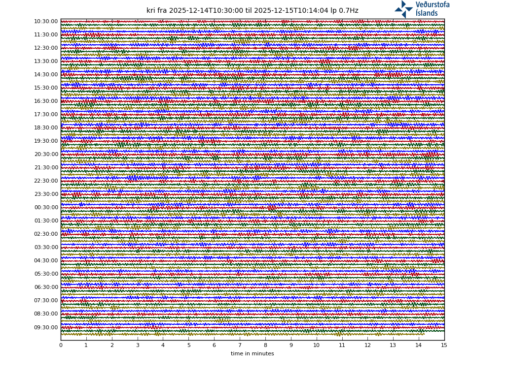
Compared to highpass:
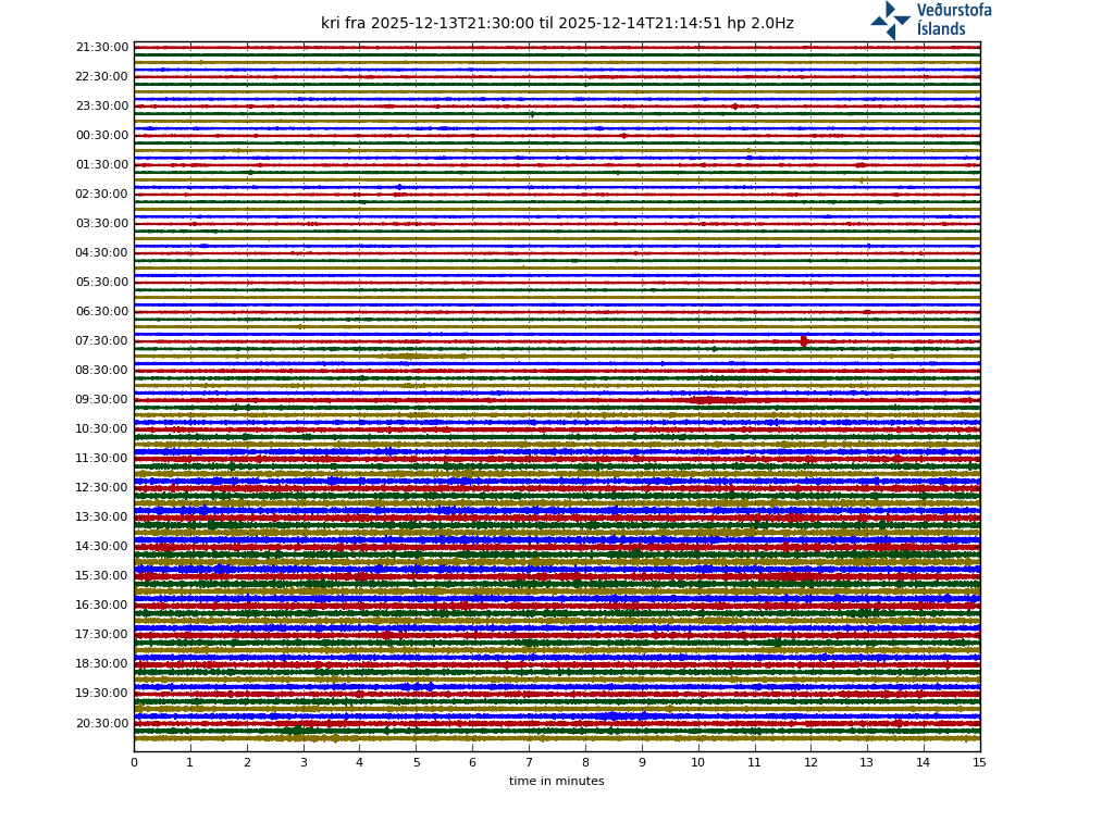
I don’t see any pictures in your comment, but there is a teleseism from the large NZ earthquake that’s visible in the lowpass plot but not in the highpass one.
TSUNAMI WARNING: The first waves may have reached NZ in the areas around East Cape at approximately 3:34am. Tsunami activity will continue for several hours and the threat must be regarded as real until this warning is cancelled. More info at
https://www.civildefence.govt.nz
Very interesting article
https://www.mbl.is/frettir/innlent/2021/03/04/liklega_byrjun_a_gosskeidi_fari_ad_gjosa/
Probably the beginning of a eruption begins to erupt
Yes! Thanks for linking the article. Worth to challenge Google translation, my opinion.
From mbl.is, interview with Magnús Á. Sigurgeirsson, geologist at ÍSOR.
=======
“If it starts to erupt, it would probably be the beginning of a period like this, for a few centuries I would think. It has at least been like this for the last three times, and further back in fact, but there is not as accurate data on it, “says Magnús Á. Sigurgeirsson, geologist at ÍSOR, in a conversation with mbl.is today. He gathered information about the last eruption period on the Reykjanes peninsula and the lava flows that flowed each time. The main points of the summary can be read here:
There is good knowledge about the last three eruptions on the Reykjanes peninsula, which lasted 3,000-3,500 years, 1,900-2,400 years and then 800-1240 AD. is stated in the summary. Magnús bases it on geological maps of the Reykjanes peninsula and the book Náttúruvá á Íslandi, volcanic eruptions and earthquakes.
Research has shown that in the second half of the Holocene ([modern geological context] covering the last 11,700 years) eruptions have occurred in the systems every 900-1,100 years. The first part of Hólósen is more uncertain due to fewer and more inaccurate age analyzes.
Each eruption seems to last for about 500 years, during which time most volcanic systems become active, but usually not at the same time. The volcanic activity is characterized by fires that last for several decades each. The lava flows from fissure fissures that can be up to 12 kilometers long.
On the Reykjanes peninsula, there are six volcanic systems that line up diagonally according to it in the NA-SW direction. To the west is the Reykjanes system and to the east are systems named after Svartsengi, Fagradalsfjall, Krýsuvík, Brennisteinsfjöll and finally Hengil.
The last volcanic eruption lasted for about 450 years.
During the last eruption, the eruption activity began around 800 AD. in Brennisteinsfjöll and in the Krýsuvík system. In Brennisteinsfjöll Hvammahraun flowed and in Móhálsadalur Hrútafellshraun flowed.
In the 10th century, the Brennisteinsfjalla system erupted again and e.g. Svínahraun lava field (Kristnitaka lava field) in Þrengslar, Húsafellsbrunur in Heiðmörk, Breiðdalshraun, Selvogshraun and Tvíbollahraun / Hellnahraun.
About half a century after these fires ended, eruptions began in the Krýsuvík system in the middle of the 12th century, probably in 1151. These fires are called Krýsuvík fires. Written sources indicate that they ended in 1188. Lava flows in the Krýsuvík fires are Ögmundarhraun, which is to their south, Mávahlíðahraun and Kapelluhraun. Ögmundarhraun destroyed a.m.k. one farm that can be seen signs of in incinerators.
After a break of about 20 years, the Reykjanes fires that lasted during the period 1210-1240 begin and mark the end of a 450-year-long volcanic eruption. There is very good knowledge about the progress of Reykjaneseldi 1210-1240. The fires started with an eruption in the sea at Kerlingarbás in Reykjanes (a short distance north of Valahnúkur). After this, the volcanic activity moved ashore and Yngra-Stampahraun flowed from a 4-kilometer-long series of craters, probably in 1211. According to written sources, it erupted at least six times in the Reykjanes fires. Volcanic eruptions can be traced from the Reykjanes eruptions in Þingvallasveit and Borgarfjörður from around 1226 and in Álftanes from around 1231. About twenty years after the Yngra-Stampagos eruption, a fissure eruption began in the Svartsengi system and in the period 1230-1240 Eldvarpahraun, Illahraun and Arnarseturshraun flowed. After that, the fires end and there has been no lava eruption on the Reykjanes peninsula since.
========
The article shows a nice map with lavafields from the last active episode 800 – 1240. Please follow the link above.
Reminds me a lot of Alberts article about the RP from 2/2020. 🙂
Agreed about Albert, and Irpsit, too.
Swarm continues with little change… is there any estimates of the volume of the magma thats on the move?
10% of a swam intrusion is what usualy erupts…
Afternoon all,
I have had a couple of user reports of various login issues (unable to login, frequent login required, getting kicked out etc)
Has anyone else experienced this?
I have to log in (“fill in your details….”) at every single comment, even when I tick the box “save name,…” etc.
This have been so since I can remember. So, many years.
English-language interview with Icelandic geologist Helga Kristín Torfadóttir on the activity to date and prospects for an eruption:
https://www.ruv.is/frett/2021/03/04/volcano-update-expert-interview-in-english
A lot more 1 Km ish deep earthquakes; is this 0.0 km deep the one that broke the crusts back?
Thursday
04.03.2021 16:45:01 63.911 -22.248 0.0 km 0.6 90.01 1.6 km NE of Fagradalsfjall
Testily testing the testosaurus,
Don’t let the testosaurus bite your testies. Or is that the testiesaurus? Ballodon ferox. Sackosaurus rex.
Always had and still have (but very long time silent) to “fill in my details below”. We geologists don’t talk about our below details publicly that much. Only to enter volcanocafé and talk lava. And magma. And stuff.
Testy Mctestface!
testing hell!
Test of the d’Uberville.
(that’s cheap and bad, but whatever…)
Are you going for a holiday in Thestaloniki this year?
“Yesterday’s events are over,” said Elizabeth Pálmadóttir, a natural resources expert at the National Weather Service. She attended a meeting of the Scientific Advisory Council this afternoon, which included a review of a satellite image taken yesterday.
Elizabeth says the photo, taken after the unrest pulse at Bowling in the middle of the day yesterday, does not show much change from the last photo taken on the first day of the month.
“The pictures still suggest that there is echoing with a northeast/southwest strategy and possibly that at yesterday’s event there was not a lot of dynamic on the pit of the journey,” says Elizabeth.
She points out that traces of yesterday’s unrest were not highly visible in the new satellite images. Therefore, there can’t have been a lot of dynamic near the earth’s surface.
Elizabeth points out that yesterday’s unrest is no longer visible, but we are still standing in a vigorous earthquake.
The quake appears to be moving southwest, towards Mount Fagradals. Elizabeth doesn’t say it has to mean anything special other than a tense change.
https://www.mbl.is/frettir/innlent/2021/03/04/ummerki_um_oroapulsinn_litt_sjaanleg/
Not much magma involved in the dyke, my interpretation.
A nice 360° panorama of the area is here: https://www.iceland360vr.com/panorama/fagradalsfjall/?src=hp
Looks like its acually is going to erupt… magmatic tremor is hammering constantly
Two more life cameras, one is thermal. https://www.livefromiceland.is/
A thermal camera is a great idea, especially in a place with a lot of bad weather!
Thank you! Just a few minutes ago I thought: “A thermal cam at Mt. Keilir would be nice to have.” 🙂
THX for sharing!
Curios for the first IR by night view!
The VIS-cam has even a windshield wiper! It’s like dreaming from a better world…
As we wait and wait and wait…
Is there a small chance to see an animal in the IR-cam? Not a huge wild-life on Iceland island…
What’s about an Arctic fox? Last seen in Reykjanes peninsula .. century?
corrected as requested – admin
comment deleted on request by commenter – admin
Take a look at this webcam. I think there is outgassing in front of the cone – lower left quadrant; unless its dust getting kicked up, but looks like its outgassing to me.
https://www.mbl.is/frettir/innlent/2021/03/04/keilir_i_beinni/
It can’t be dust because the ground is wet.
ignore me, it was just image stabilization. Delete.
Thermals are clear, I think its most probably just low cloud and wishful thinking at the moment
It is safe to say that something will soon happen, Jesse Pinkman and Walter White
are getting the hell out of there…
https://ibb.co/6NZ1ZKg
https://www.mbl.is/frettir/innlent/2021/03/04/ummerki_um_oroapulsinn_litt_sjaanleg/ is activity beginning to increase here?
USGS VNS Unsubscribe
AVO/USGS Volcanic Activity Notice
Volcano: Veniaminof (VNUM #312070)
Current Volcano Alert Level: WATCH
Previous Volcano Alert Level: UNASSIGNED
Current Aviation Color Code: ORANGE
Previous Aviation Color Code: UNASSIGNED
Issued: Thursday, March 4, 2021, 9:04 AM AKST
Source:
Alaska Volcano Observatory
Notice Number: 2021/A39
Location: N 56 deg 11 min W 159 deg 23 min
Elevation: 8225 ft (2507 m)
Area:
Alaska Peninsula
Volcanic Activity Summary: Regional
infrasound sensors detected a small explosion from Veniaminof volcano
this morning at 14:13 UTC (05:13 local time). Satellite and webcam views
indicate low-elevation (< 10,000 ft asl) ash emissions heading in
the SSE direction, and minor ash deposits are visible at the volcano. As
a result, AVO is raising the Aviation Color Code to ORANGE and the
Volcano Alert Level to WATCH at Veniaminof volcano. The local seismic
data remains offline due to an outage of a satellite link at Port
Heiden. However, the Alaska Volcano Observatory continues to monitor
Veniaminof with satellite and webcam data and remote infrasound, seismic
and lightning networks.
Eruptive activity usually consists of minor ash emissions, lava
fountaining and lava flows from the small cone in the summit caldera.
Ash emissions are typically confined to the summit crater, but larger
events can result in ash fall in nearby communities and drifting
airborne ash.
Recent Observations:
[Volcanic cloud height] 10000 feet asl
[Other volcanic cloud information] SSE direction
Does anyone have any comment? It looks like activity has picked up on this station https://www.mbl.is/frettir/innlent/2021/03/04/ummerki_um_oroapulsinn_litt_sjaanleg/
There is more activity now near the blue lagoon.
Thanks Albert Do you have a link to what you are seeing?
Try https://en.vedur.is/earthquakes-and-volcanism/earthquakes/reykjanespeninsula/#view=table
M7.8 reported between New Zealand and Tonga. Strong enough that USGS detected it as two quakes .
Arrival of p-waves caused a false detection of an M4.8 near Katla.
Magma is now 4 to 6 kilometers underground… just below where gases starts to bubble out…
When nucleation starts.. the tremor will really pick up speed…
Is this going to erupt?
Not sure. I’m leaning on no at the moment
IMO geologists are quite leaning on that it will erupt… since the tremor never stops
It will probaly be a small fissure eruption perhaps 60 million cubic meters and a short lived ocean entry thats coast 7 kilometers from Keillir. The road to reykjavik coud be blocked by Aa lava
https://en.vedur.is/earthquakes-and-volcanism/earthquakes/reykjanespeninsula/
The swarm is picking up speed… soon hawaiian style fire fissures will open and pour out sheets of fluid basaltic lava
More than likely i suppose since the activity has been ongoing non-stop for such a long time. However, with the magma still in the 6-4km depth its hard to say exactly where the lava does breach the surface, so i would be a bit worried if i was living in Grindavik or nearby (Blue Lagoon) even though the center of the earthquake activity the past week has been closer to Keilir.
How far did the magma from Bardarbunga travel from the depth of 5km back in 2014? How different/similar is the geology, topography of the rifting and hardness of the ground rocks around Bardarbunga/Holuhraun compared to Reykjanes?
What’s this at skogar? Is the Cork of the bottle, and everything is getting unstable
Its just Katla that makes sure we do not remember her!
forget* (not remember)
Probably the 8.1 at the Kermadecs?
https://earthquake.usgs.gov/earthquakes/eventpage/at00qpgm3n/executive
Yes, the p-waves are visible on the lowpass drumplots. S-waves will soon show up as a very low frequency signal.
Friend in NZ just messaged me this
‘Wow – and my mother just texted me to say a decent sized river near where she lives just got sucked out to sea!”
@Sjonni_KAUST
The surface deformation southwest of Reykjavík as seen by Sentinel-1, indicating continued opening along a NE line. Tremor yesterday, but no eruption, yet. The ascending-orbit interferogram spans 25 Feb – 3 Mar, by Adriano Nobile @KAUST_PSE @ESA_EO
https://twitter.com/Sjonni_KAUST/status/1367568116302151683
https://twitter.com/Vedurstofan/status/1367569547734179845
Tremor pulse detected 14:20 yesterday, lasted a few hours, detected by most seismic stations in Iceland. Located S of Keilir. Earlier today there have been two quakes larger than M4, up to 30 M3 or over. From midnight just over 2200 quakes measured in the area, no signs of tremor
well i guess i’ll take all this popcorn and watch the tsunami roll into South America/New Zealand and Australia then… See Ya Later….
The eruption… Wheehere is itt? wheeerreee isss it? its ouuurs it isss… and WEEE WANTS ITT!!
Myself waiting for the eruption : )
This link shows the offset of the GPS stations in the area. https://notendur.hi.is/~hgeirs/iceland_gps/rnes/rnes_100p.html
The tremor is going so constantly. Swarm continues with little change…
is there any estimates of the volume of the magma thats on the move?
10% of a swarm intrusion is what usualy erupts…is there any estimates how much thats on the move below Keilir? Leilani swarm began with 300 million cubic meters on the move cuttting its way though ERZ. If this stuff erupts perhaps… it will be like Krafla fires.
What is happening now in Iceland intrigues me. Now activity is shifting westwards to the blue lagoon again. It literally inverted it’s direction and crossed 3 volcanic systems.
If this is solely caused by rifting, then the question is what is driving the process. If its tectonics, then rifting across a wider area lowers changes of an eruption, as magma just fills the gap and loses pressure. If its driven by magma then an eruption would be granted because this means there is an wider area that magma is stirring up. I lean more for first option.
If this process is fundamentally driven by tectonics, then We still might be months or years from an eruption.
But I believe that a new cycle in Reykjanes has just began. It will erupt a few times this century.
What also intrigues me is that, this time activity is about to start near Reykjanes and Krisuvik. Last few cycles it started always east near Brennisteinfjoll.
The previous swarms in the sequence from December 2019 have moved westwards. My guess is that this is driven by tectonics or even the crust accommodating the deformation to the east at Vatnajökull from the mantle plume. But, volcanologists would be using more than seismic and deformation data, they use infrasound and gas measurements too to work out where the magma is etc..
Gps krisuvik and vogsosar on the eurasian plate were moving south east past week. Vogs is southeast of the brennisteinfjöll system, so a larger area. The north american gps are moving northwest to northeast mainly. Because the movement affects such a large area, several volcanic systems, tectonics play the leading role I think. It could explain the shifting of eq’s between the systems and along the faults.
Far as I can find data on older cycles only includes 3 other examples before its too obscure to tell. 3 isnt really a big sample size, so this cycle starting in the middle of the system instead of the east end might not be that weird. Also the possibility that this actually did happen in the middle ages, all of the fault line was simultaneously active but with progressive eruptions going westward.
There hasnt been an eruption yet, and there isnt a guarantee of one still happening with this swarm, who knows how many of these happened in the last episode which didnt have eruptions and would have largely been unnoticed or confused with tectonic quakes that happen there anyway. Maybe even it is just a pure coincidence the activity started in Brennisteinfjoll the last times, it does look like in the last few millennia Krysuvik has been more productive based on the area covered by its lava maybe it isnt surprising this started there.
Chad, as we know from Hawaii, the hot plume or the crust or both are on the move. Would you confirm that is the same for Iceland and his hot plume? Is growing Iceland the new Greenland? Isotope rate from Iceland to Greenland are…
The Reykjanes webcam is up. Anyone know what direction it is pointing in? ie. is it looking at moon-rise or something more interesting?
https://www.livefromiceland.is/webcams/reykjanes/
Nothing on the other cams … so must be moon-related.
Or a nearby town …
Saw some fireballs on RUV webcam
Put some pics on my twitter feed (handle is the same as my user name here). I don’t seem to be able to post them here
Aircraft, we are after all rather close to the airport
Which way is the camera pointing? Are they planes?
Is this the link for the camera?. https://www.ruv.is/frett/2021/03/03/beint-vefstreymi-af-skjalftasvaedinu-vogastapi
this camera https://www.ruv.is/frett/2021/03/03/beint-vefstreymi-af-skjalftasvaedinu
pics here https://twitter.com/LorcanRK/status/1367593124210479104 and here https://twitter.com/LorcanRK/status/1367596969854705664
They might be reflections of lights from cars on the road…
I’m sure a regular will have answered this before I escape the dungeon, but those mystery lights are just lens artifacts caused by car headlights. Watch an approaching vehicle and all is revealed.