The largest eruption of the 21st century happened at sea. And it wasn’t Hunga Tonga.

Mayotte
The Comoro islands form a forgotten archipelago, somewhere between Africa and Madagascar with about 200 kilometer of open ocean on either side. On the African side the nearest land is the northern end of Mozambique, close to the border with Tanzania. On the other side it is the northern tip of Madagascar. The closest I have been myself is on the border of Malawi and Mozambique. The scars of the civil war were clearly visible on the Mozambique side, with houses pockmarked with bullet holes, whilst Malawi was in the midst of the AIDS epidemic with fresh graves an all too common sight. Sometimes this brightest and most beautiful of continents seemed a dark place. Madagascar is a different world from Africa, settled from the far side of the Indian ocean, but it too is among the poorest countries in the world. The Comoro Islands are in between, neither Africa nor Madagascar. They were settled by a diverse mixture of people from Southeast Asia (like Madagascar), Africa (perhaps with a slavery heritage) and Arabia. The islands are now densely populated but there are few resources and poverty is widespread. It is a struggle to grow enough food for everyone. Life can be hard even in beautiful places.
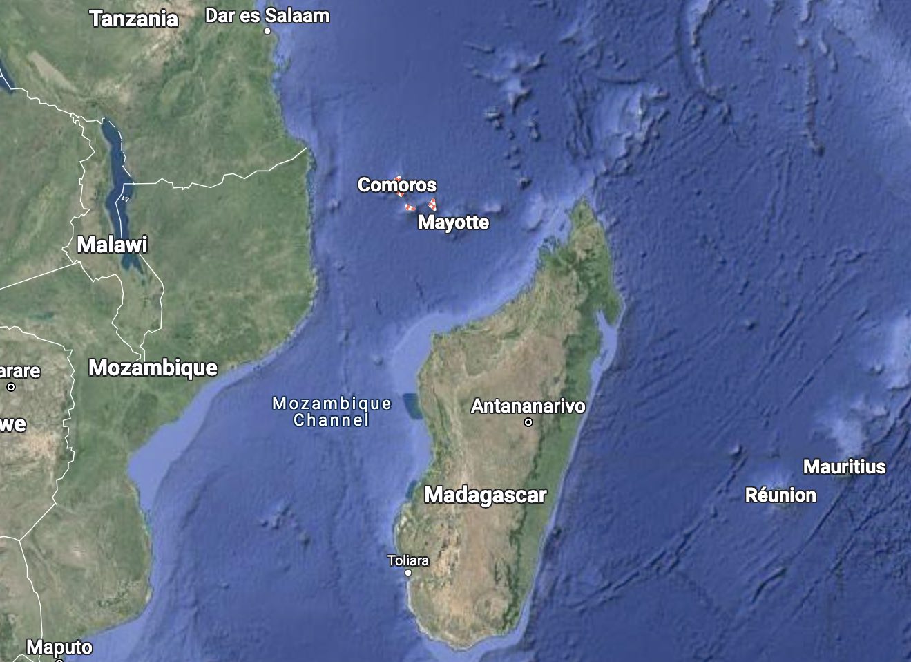
There are four main islands. Three are part of the Union of the Comoros, an independent nation consisting of Grande Comore, Mohéli and Anjouan. Together they form one of the smallest countries on Earth. There are local names for the islands: Grande Comore is called Ngazidja, Mohéli is Mwali and Anjouan is Ndzwani. The fourth island is politically separated: Mayotte voted against independence and remains administered by France. Perhaps wisely so: the Comoros are known for the large number of coups (two of which were in the first 6 months of its independence) and for political instability. At one point two of the islands tried to rejoin France but this was refused by France. Since 2010 the political situation has become more stable. The name ‘Comoros’ is sometimes used for the four islands together, and sometimes for the Union of the Comoros.
The islands are volcanic in nature. We will come back to this after the evolutionary interlude.
Evolutionary interlude
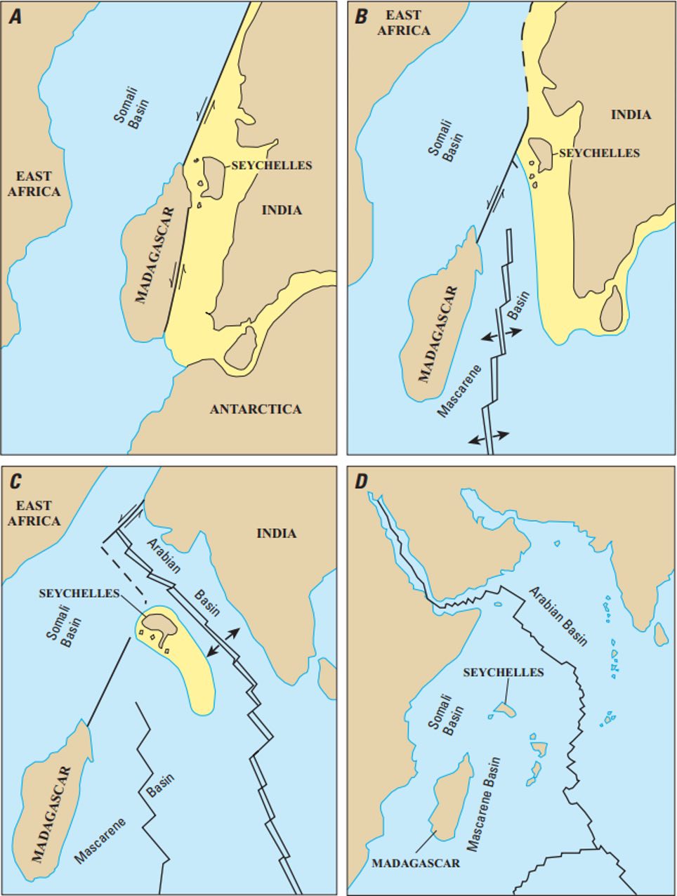
The region has suffered its share of geological upheaval. Madagascar originally came from Africa. (It actually had a separate existence in an earlier life – we may come back to that.) It split off from Africa during the break-up of Gondwana. The split-off was far larger than Madagascar is now: the entirety of India was attached to the west side – and India itself was larger than it is now. The rift developed along what is now the coast of Tanzania. Other rifts were active elsewhere. Gondwana was breaking up, but the break was not a clean one. Subduction zones around the edges of Gondwana were pulling the supercontinent apart, looking for weaknesses. Many rifts tried to form, some successfully, some quickly superseded by others. Some regions drifted off only to be stopped in their tracks as the rift behind them failed. Others kept moving: Antarctica severed its connection to India at this time.

Source: Wikipedia. Jurassic break-up of Gondwana
After the rifting, the Madagascar-India fragment (pretty much a continent in its own right) drifted southward and away from Africa. But the rifting failed to progress and Madagascar was left stranded. A new rift developed on the east side which split off India from Madagascar. The process was very similar to the opening of the North Atlantic, much later, where at first Greenland split from Canada but was left behind when a new rift opened on the other side. The tip of Greenland and the tip of India still show the same angled shape, a meeting point of rifts. Madagascar was left with a straight edge on the eastern side, formed by this new rift.
India now went its own way; the learner-driver would soon smash into Asia. Madagascar was left behind, powerless but safe. India in fact suffered another accident as well. It hit a hot spot which carved a straight line along the western side, removing a bit of the continent. The cut-off moved away to become the Seychelles, a microcontinent stranded in the middle of the Indian ocean. The Seychelles have grown since: it joined forced with the trail of volcanic islands left by the hot spot, stretching as far as Reunion. It is now known as the Mascarene plateau, the second largest oceanic plateau in the Indian ocean after Kerguelen. But only the northern part of this is continental crust. The rest is oceanic.
Source: Wikipedia
While the Deccan hot spot carved its line into the Indian ocean, the spreading rift jumped east again.
The African plate immediately reclaimed ownership of the western side of the new rift. Madagascar had already rejoined the African plate – now the Seychelles did too. The African plate became the proud owner of the oceanic crust of the western Indian Ocean, and of the two continental fragments of Gondwana it contains.
India, Madagascar and Mozambique have an ancient continental crust. All of these continents and microcontinents are remnants of Gondwana. Of course they are more than that: they existed before Gondwana and they will still exists when the Indian ocean is long gone. Continental crust outlasts the continents they were part of.
Geology wasn’t finished yet with Africa. 30 million years ago, the Afar hot spot separated Arabia from Africa. Since that time, some of the rifts left by the Gondwana fragmentation have re-activated. This has formed the East Africa Rift, which is in fact a combination of different rift fragments. One branch has extended off shore where it formed the Kerimbas graben. Further south lies the Davies Ridge, a remnant of the transform fault along which Madagascar and India moved south. In the future the newly activated Kerimbas graben may link up with this system. There are sea mounts here: the appropriately named St Lazarus, as well Paisly and the Sakalaves. The off-shore rift is becoming volcanic.

Source: Courgeon et al. 2018, Terra Nova https://doi.org/10.1111/ter.12353
Comoros volcanism
Unlike the trio of Madagascar, the Seychelles and Eastern Africa, the Comoros are not related to Gondwana. They are solidly part of the oceanic kingdom. The islands are sitting in a 3-km deep ocean, and in common with all deep-sea islands, are volcanic in nature. If you imagine the sea away, what is left are four steep, tall, isolated mountains sitting on a deep plain. There could be no doubt that these are volcanoes. There is no continental crust here: the Comoros archipelago is a true outlier in a sea of continents.
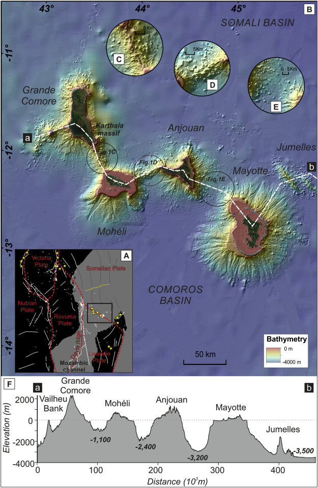
Comoros
The Comoro Islands form a rough east-west line. This direction already shows it is not related to the off-shore section of the African rift which is nearby but runs north-south. The figure shows a cross section (rather bend) which crosses the main islands. It shows two additional peaks, Vailheu Bank just below sea level and Jumelles at a larger depth. Vailheu Bank is a well-known diving location, good for hammerhead sharks. The deep ocean here is known as one of the few locations where coelacanths still exists, albeit far too deep for divers!
The age of the Comoro Islands is not too well known. Volcanism probably dates back to 15-20 million years ago at Mayotte, and perhaps 10 million years for the other islands. The activity has continued until close to the present day, at all islands. Clearly, this is not a Hawai’i-type hot spot trail.
The islands were build up by the usual processes for volcanic islands. These are four-fold.
- Inflation. The ocean crust begins to rise because the heat and melt reduces the density. A bulge forms
- Eruption. Lava erupts and builds up new surface layers. This combines with the continuing inflation to build up the cone, which now breaks the surface.
- Land slides. The steep cone suffers frequent collapses which spread out debris over the slopes and surrounding area.
- Wave erosion. This creates a plateau, some 10 to 50 meter below sea level. The plateau can be at different depths (or heights) if the sea level has changed over time.
The third one is often overlooked, but may be responsible for the majority of the volcanic islands. We have seen examples in recent years, for instance with the complete sudden collapse of Anak Krakatau. Hunga Tonga’s ejecta also seem to have ended up as submarine flows: the volume of those may even include material that came from outward collapse of the caldera, and was not part of the original explosion. Seamounts are built out of debris.
The plateau phase is clearly visible for Mayotte.
Grande Comore

Grande Comore
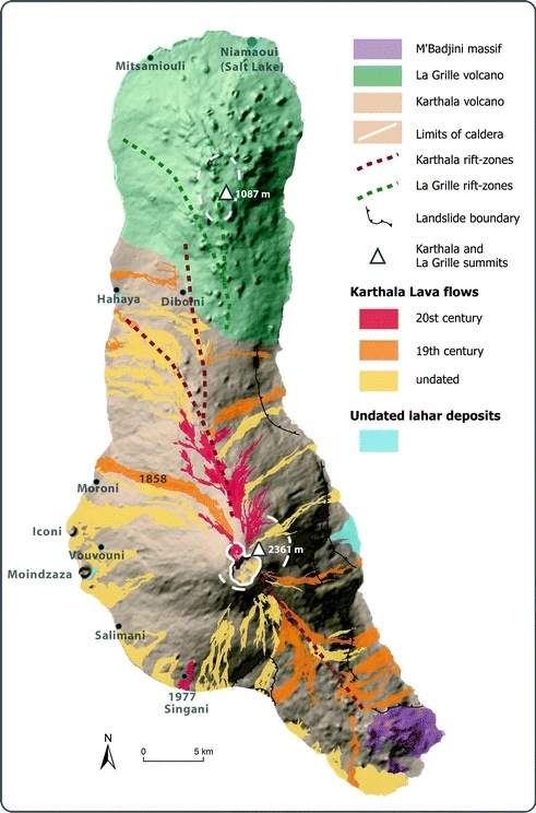
The island of Grande Comore is 65 km long and 20 km wide. It is built around three volcanos. In the north is a dormant volcano, La Grille which reaches just over 1 km. It has had numerous fissure eruptions, each of which build a separate scoria cone, not unlike La Palma’s eruptions. The most recent eruption may have been within the past few hundred years. One eruption is dated to 700-1000 years ago. Pottery found in the fall-out shows that this was after people had first arrived here, which also places it within the past 1000 years. However, there is not a single historical report of an eruption from La Grille.
The southeastern tip of the island contains the M’Badjini volcano, 740 meters tall and extinct. One of its lava flows has been dated to 130,000 years ago. There is also a submarine volcanic ridge to the southeast of Grande Comore but very little is known about it.
Lava flows from Karthala. Images from Patrick Bachèlery, Structure and Eruptive History of Karthala Volcano, 2015, in Active Volcanoes of the Southwest Indian Ocean)
The island is dominated by a central, highly active volcano, Karthala. Karthala is over 2km high and regularly erupts – most recently in 2005-2007. The volcano has a shape somewhat reminiscent of Mauna Loa: a long mountain with two rift zones. Eruptions tend to be effusive and can take place in the caldera, along the rift, or sometimes from locations low on the flanks. Phreatomagmatic explosions are also relatively common. The caldera is about 3 km across, and consists of several separate collapse features which surround a central main crater. Each collapse forms a crater which is typically 1-1.5 km diameter. The central caldera often changes in appearance. Whenever it is more than 300 meters deep, a green crater lake forms. This was present briefly in the 1940’s and 1950’s and longer lasting in the period 1991-2005.

The caldera of Karthala with the lava-filled pit crater
In 1918, an explosion formed a pit crater in the northern part of the caldera. Over the years the depth decreased, and in 2007 lava erupted and filled in the crater perfectly, as shown in this picture.
Karthala is one of the two most active volcanoes of the southwest Indian Ocean. The other one is far famous: Piton La Fournaise. Karthala, in contrast, may be the most overlooked volcano on Earth. Inaccessibility is part of this: there are no roads up the mountain, and the slopes are covered in dense rain forest. The upper range is barren, due to the frequent eruptions. These eruptions take place in a 45-km long and 8-km wide zone along the ridge of the island. Currently, most activity is in the northern rift but over longer times both the northern and southern rifts are approximately equal.
The magma production rate is estimated at 10-3 km3/yr which makes it a moderately active system. But it is not harmless. Much of the island is in reach of its lava flows, and these have in the past reached the coast. Eruptions in the 19th century often involved the rift zones, including five eruptions in the period 1857-1862. After 1903, eruptions mostly remained within the caldera with as exception only the 1977 eruption. The eastern side of the island is covered in lava flows of a variety of ages, some fresh looking and others old grey. The western side shows much less evidence but this is because of the climate. The eastern side is much drier while the western side gets the rain and is densely vegetated.
In 1859, a caldera eruption produced a lava flow which traveled 13 kilometers down the northwest slopes. It reached the coast just north of the capital, Moroni. In 2003, gas emission from the southwest rift zone killed 13 people. The 1977 eruption started on April 5, low on the western flank, just north of a village. A new scoria cone grew and a’a lava travelled through two villages before reaching the coast. Almost 300 houses were destroyed. In 2005, explosions covered the island in ash and pumice, causing lahars especially on the west side of the island. Karthala is a hazardous volcano! And with close to half a million people living on Grande Comore, there are a lot of people at potential risk.
There is another hazard. The east side of Karthala is unusually steep. This seems to be the scar of a large landslide. This happened a long time ago and the slope has been stable since. But there is evidence of other collapses: the submarine slopes to the southwest of Karthala are covered in debris flows. Flank collapses are very infrequent, but they can be devastating when they happen. And unlike eruptions, flank collapses may not give much warning. This volcano is not to be trusted.
Mohéli
This is the smallest of the Comoros islands covering no more than 300 km2. The island is longer than it is wide. There is a central ridge some 800 meters high which is the remnant of the original large shield volcano, now deeply eroded. The western side is rugged, while the eastern tip of the islands is lower lying. Dating of the flows has indicated that there were two volcanoes, a younger western one and an older eastern one. The volcanoes grew between 5 and 2 million years ago. Little is left of the eastern volcano. The western one had a flank collapse on the eastern side, perhaps 2 million years ago.
Mohéli is sitting on a plateau, which (as discussed above) shows its age. On the southern side there are a number of small islands which form ridges pointing at Moheli itself. Interesting, these originally were eroded valleys on the flank of the volcano. Later lava flows filled in the valleys, and now erosion attacked the region around it but left the harder lava in place. The outcome was a series of radiating lava ridges. As the island sank back, the ridges became islets. These lava flows are among the last eruptions here. They are dated to between half a million and one million years ago. This also formed some strombolian cones and maars.
Everything points at Mohéli having a deep volcanic history, but it lacks a volcanic present. Its volcanoes have been extinct for half a million years.

Mohéli
Anjouan
The island of Anjouan has a different shape but a similar history. It is a triangular volcano which like Mohéli started out with one volcano, after which a rift volcano (Hawai’i like) developed. The central volcano (or its remnant) is called N’Tingui. It is up to 4 million years old although the basement is likely much older. The rifts are dated to around 1.5 million years ago. After that, a series of pyroclastic cones and maars formed, some of which are clearly visible in the map. The youngest volcanism date is 370 thousand years ago.

Anjouan
Anjouan contains a geological mystery. There is an outcrop of white quartzite on the island which is completely out of place on a basaltic volcanic island. The ocean floor here is 150 million years old. The quartzite must be much older.
Quartzite is compressed sandstone, from a sandy sediment that formed in a river valley. The compression requires high temperature and pressure, and normally happens as part of mountain building. It did not form in the rifting of Africa. If mountain building was required, then this compression happened during the continental collision that created Gondwana. The sand itself must have come from even older mountains.
When and where could this have happened? Supercontinents tend to break up along the approximate original sutures. That is true for the Atlantic ocean: it separated Europe from America along the approximate line where the two had first come together, now traced by the mountains chain running from Norway via Scotland to the Appalachians. So it was in Gondwana. One part of Gondwana had formed when India and Madagascar collided with the old cratons of Arabia and Africa (mainly the Congo). This was the East African Orogeny, and happened over a period of time around 600 to 550 million years ago. It build a north-south mountain chain covering part of Africa and Madagascar.
Shortly after (520 million years ago) the combination collided with East Antarctica and the Kalahari craton in the so-called Malagasy orogony, which affected Madagascar and southern India. It build an east-west mountain chain from Malawi across my war-like border with Mozambique into what is now Sri Lanka. The exact order in which the fragments came together is disputed, but the effect was two mountain chains in a ‘T’ shape, with the join near Madagascar. These mountains could have been the source of the quartzite. Erosion from the older mountains could have provided the sand, collecting in river deltas, and the second collision could have compressed it into mountains. Much later, India and Madagascar broke off, as described above, near the same suture. And somehow a layer of the compressed quartzite ended up underneath what is now Anjouan.

Source: wikpedia
The details of this scenario of the origin of the quartzite are speculative! And the ‘somehow’ in the previous sentence leaves a lot unexplained. It is clear, however, that the quartzite must come from a continental remnant and is not related to the eruptions that build the island. It is a memory from Gondwana, a lost fragment which ended up mid-ocean.
The sandstone lay buried below the ocean floor. When the Comoros inflation which build the island began, it ended up above sea level. The quartzite shows indications that it interact with magma, suggesting the magma had gone through the quartzite layer. But in that case, how did it end up on top of the island?
We can try to fill in the mysterious ‘somehow’ using a bit of physics. To end up on top of a growing mountain, you need vertical motion. Quartzite is a silicate, and therefore relatively low density: 2615 kg/m3, while solid basalt is typically 2950 kg/m3. Liquid basalt (also known as magma) is a bit less dense, but at typically 2700 kg/m3 still a bit more than the quartzite. So if there is a magma chamber directly above the quartzite, the quartzite has buoyancy and will attempt to float. For this to happen, the magma chamber should obviously be larger than the block of quartzite – it has to fit in the magma bath in order to float.
The Comoros magma came from 50 km deep, from the mantle. As it moved up, a magma chamber formed perhaps 15 km deep – right where the quartzite layer had ended up. A quartzite block dislodged, and began to float up in the magma. As the magma chamber moved up, the quartzite came bobbing with. The float ended a few kilometers below the surface from where the magma began to rise in narrow conduits. Now two things happened. The top of the mountain suffered erosion and collapses. While this happened, the mountain lost a bit of weight, and hydrostatic pressure from below pushed the mountain a bit back up – just like an iceberg with the top removed. So the quartzite block ended up higher, with less mountain above it, and came up a bit higher. Now that Anjouan has been extinct for a while, the quartzite has ended up on the surface, halfway up the remaining peak.
This block has an interesting story to tell, which I hope I got right. The indications for interaction with magma wasn’t because magma rose through it -instead it rose through the magma. It is a bit of Gondwana in a location where it should not be. This outcrop on Anjouan is a third fragment of Gondwana in the Indian ocean.
Mayotte

Mayotte, as seen by Sentinel
Mayotte is famous for its nature. If you like wild orchids, Mayotte is not a bad place to explore. (You will need to decide whether to go for the rainy season though.) The densely populated island is surrounded by a wide coral reef forming a double barrier reef. The reef surrounds one of the largest lagoons in the world, compared to a natural aquarium with reef fish, turtles and dolphins. It is up to 100 meters deep, covers an area (not including the island) of more than 1000 km2 and contains a hundred places where the coral has formed small islands (at least at low tide). The lagoon is in fact a large submarine plateau. It is not always submerged: at places there are gaps in the barrier reef which were formed by rivers at a time when sea levels were lower. The plateau already indicates that this island is older than the others.
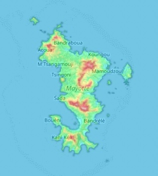
Topography of Mayotte
The island itself is not high (just over 600 meter) but hilly in places. A topographical map shows four or five separate volcanic remnants, which together make up to complicated outline of the island. Mount Choungi in the south is a good example: a steep cone, just under 600 meter high, with a reasonable track (dry season only, and some scrambling required) and great views. There are other remnants: Dziani Dzaha is a crater lake on the Petite Terre island where the airport is. The ferry to this island only takes about 30 minutes, making it a worthwhile diversion during a visit. There are three or four other apparent craters and calderas along the east side of Petite Terre, all of which are missing their eastern half in a possible flank collapse.

The craters of Petite Terre
The shield volcano that made up the island is 10-15 million years old. The oldest lava found on the island is 8 million years. The lava flows continued until 1.5 million years ago. Like the other islands, there were multiple volcanoes, each active at a different time. The older volcanics formed the southern side of the island and the younger activity was in the north. The eruptions largely ceased a million years ago. There have been a few minor eruptions since. An ash layer found in the coral has been dated to 7000 years ago. It is not clear where this ash is from, but it may be the formation of Dziana Dhana. (Alternatively, the prevailing winds mean that Grande Comore is a possible origin; this is also the only island anywhere near with active volcanoes.) GVP lists two more recent pumice layers. Gas emissions have been registered on Petite Terre. It seems plausible that there is some volcanic activity on the eastern side of Mayotte, causing rare phreatic explosions but not producing any magma, and not clearly related to the older volcanoes here. Perhaps this was not the best place to build the airport.
The normal future here would be that Mayotte would begin to sink, while at the same time the coral barrier reef grows. Eventually, an atoll forms; It would be much like Mayotte is now but without the island and with a slightly higher reef. But the longevity of all the Comoros islands shows that volcanism here has a tendency to return. Mayotte may not be finished yet. Perhaps a new volcano will eventually grow up and rejuvenate the island. It is worth keeping an eye on the stirrings at Petite Terre.
Origins
![]()
By why are the Comoros here? There is no obvious cause for this volcanism in the Mozambique channel. It is well away from the sea mounts closer to Africa. A mantle plume has been proposed, of course, but it lacks any evidence. A hotspot trail has been suggested to lead from the Seychelles to the Comoros, but this does not agree with the direction of plate motion, and the Seychelles are already linked to Reunion. There is also little evidence for a tectonic fault system underlying the Comoros.
However, this last point is not as clear as the case against a hot spot. There may indeed well be a fault system here. The east-west alignment of the Comoros links the tip of Madagascar to the Davies Ridge, the remnant of the old transform fault along the coast of Africa. The Davies Ridge is an old fault, but further north it is being reactivated by the East African rift as it is extending off-shore. Obviously the time scales are extraordinary slow – tens of millions of years. Africa is never in a hurry. The net effect of the re-activation seems to be that Somalia is beginning to separate and drift off into the Indian Ocean.
For that to happen, the would-be Somalia plate also needs to cut loose in the south. The suggestion has been made that this loosening is the cause of the Comoros. A transform fault is forming which will complete the separation of the Somali plate. There isn’t a clearly developed fault yet (as shown by the lack of seismicity) but it there is now a diffuse region of weakness. 50 kilometers below, a partly molten mantle was waiting, and as the weakness developed 10 to 20 million years ago, magma started to trickle upward. Call it trickle-up magmanomics, if you wish. This model of early initiation of a new transform fault explains the location and extend of the Comoros, the fact that the islands do not line up well, and the fact that volcanism here seems to be intermittent and is moving randomly between the islands.
Fani Maoré
And then everything changed. On 10 May 2018, people on Mayotte experienced a M5.9 earthquake. This was unheard of: the Comoros are (or were) seismically quiet. What followed was an eruption 6 times larger than the Leilani eruption of Kilauea that had started a week before. But that is for another post.
Albert, June 2023


About time! I am quite a bit worried that it may not have been written on, luckily it is. It is a good read, but there are some other papers also trying to explain their formation:
https://www.researchgate.net/publication/44160032_The_Process_of_Plume-Lithosphere_Interactions_in_the_Ocean_Basins–the_Case_of_Grande_Comore – Hotspot hypo.
https://www.google.com/url?sa=t&source=web&rct=j&url=https://hal.univ-reunion.fr/hal-02974675/document&ved=2ahUKEwjG_dvjx8r_AhXIlmoFHfUMBLkQFnoECA4QAQ&usg=AOvVaw1F-rIg3iHUJNH1AAMPyqov – Fault Hypo.
https://www.google.com/search?q=grande+Comore%3A+the+karthala%2C+an+unknown+volcano&oq=grande+Comore%3A+the+karthala%2C+an+unknown+volcano&aqs=chrome..69i57.23383j0j7&client=ms-android-samsung-ss&sourceid=chrome-mobile&ie=UTF-8# – a video on the expedition to the Karthala summit after the recent eruption.
https://www.google.com/search?q=eruption+du+volcan+karthala+en+septembre&client=ms-android-samsung-ss&sxsrf=APwXEdfvRlOS5j_HNc9xBjw5LnbZGpGHRw%3A1687014466953&ei=QsyNZIXUOcmrptQP5ZSZgAY&oq=eruption+du+volcan+karthala+en+Septembe&gs_lcp=ChNtb2JpbGUtZ3dzLXdpei1zZXJwEAEYADIHCCEQoAEQCjIHCCEQoAEQCjIECCEQFToKCAAQRxDWBBCwAzoFCCEQoAE6CAghEBYQHhAdOgUIABCiBEoECEEYAFDhBlivKGDVNGgCcAF4AIAB9QGIAYAPkgEFMC43LjOYAQCgAQHAAQHIAQg&sclient=mobile-gws-wiz-serp – another video thus time of the 1972 eruption of Karthala.
“Fani Maoré
And then everything changed. On 10 May 2018, people on Mayotte experienced a M5.9 earthquake.”
I know what Albert has seen as I also saw that. I won’t set a link to it as Albert is indicating that a part 2 might follow. The paper up there – Zach – is too old. The history of tectonics in the area will be rewritten. 🙂
Great article.
“Land slides. The steep cone suffers frequent collapses which spread out debris over the slopes and surrounding area.”
That’s quite common. I’ve come to think as some oceanic shield volcanoes as landslide-shields, which undergo repeated giant landslides removing the summit area of the volcano. The best example is Reunion. Both shields of Reunion have their submarine flanks made up almost entirely of landslides. Fogo, Sao Antao, and Tenerife, are the other active examples. From the looks of bathymetry, Mayotte was a landslide shield in its day. Karthala is a bit of a rift-shield instead, like Hawaii’s volcanoes, although weaker.
Not far south from there is the Agulhas slide too, which is possibly the largest in the last 10my
Kilauea news. A turn towards much faster deflation has just happened, and the eruption seems to be intensifying. Fountains are sending pieces of spatter from the wall cone to the very edge of the lava lake. The eruption/magma ascent dynamics seem a bit different this time, maybe because of the bigger intrusion/wider conduit.
1959 version 2.0 🙂
But really, if this is evolving on the path to becoming a real conduit vent then a phase like that of Kilauea Iki is likely, potentially followed by one of much more powerful eruptions with longer intervals, like Pu’u O’o. I guess eventually it will become a shield with no significant fountains, but that is far enough out that rift activity is a consideration. but based on prior eruptions high fountaining might well begin at this vent very soon if it keeps up.
1959 probably would have become a shield, but the ERZ took away the magma and the rest is history, the shields formed on the ERZ. But now the ERZ is silent, inactive, and the SWRZ is active but too high in elevation, so the summit is left to do its thing unopposed… This could get very interesting, its like Fagradalsfjall in 2021 but the magma supply is basically unlimited 🙂
Just looked at the B1 cam and in the early morning coolness there seems to be steam rising from the whole of the ring fault, along way from the lava. Significant?
https://www.usgs.gov/media/webcams/b1cam-halemaumau-and-lava-lake-down-dropped-block
Not really it has done that pretty much since it was created in 2018, steam there is more of a weather thing than a volcano thing. Same thing causes the steaming bluffs up on the north caldera rim.
Thanks. First time I saw it. I guess if there was still steam visible in the heat of day it might be a bit more significant….
I have found from my observation that plumes from the vents or flows are pretty much unrelated to the lava, they are literally the same as normal clouds and are weather related, which is why they look white. Volcanic gas plumes are blueish, I guess maybe from SO2 in the steam, or maybe sulfate nanoparticles being more likely, and then ash will tend to be pretty obvious but it looks like dust. I dont know what Pele’s hair looks like or if you can see it at all but I imagine a lot of it is being made at the vent now.
Fumaroles also tend to have sulfur aroudn them if they connect to magma, but I dont knwo if that is a reliable rule. At Kilauea there isnt a lot of alteration so in most places magma has to be within 1 km of the surface to degas SO2. The 2018 caldera before it filled with lava was an exception though and the steep walls were basically painted yellow with sulfur and sulfate minerals that were degassing out, even though magma was deeper than 1 km (well, presumably, that was never confirmed). All of that is deeply buried now though.
Most volcanoes are much better at degassing without erupting though, Kilauea is actually pretty weird, maybe because its hydrothermal system is deep and almost never exposed. Maybe had the caldera not filled in so fast after 2018 that water lake would have turned into a lake of sulfuric acid like at Kawah Ijen, and much more substantial alteration could begin, but Pele had other plans it seems, she wanted a lake but not one of water… 🙂
Will last until the caldera dam gets too heavy and drain itself into the rift
Kilauea is the closest we can get to volcanoes on Io that constantly non stop effusive lava. This is basicaly a prometheous vent stuck inside a caldera 🙂
I’d estimate that the cone is 60m above the lava lake now, aprox. 1/3 of the whole caldera wall (around 170m). But the slope has to become broader/flater to get more stable.
Apparently the fountain is 10 meters high but it isnt jetting up so doesnt give a very accurate fall reading. But you are right it does look aabout 1/3 of the wall height now, maybe slightly less but close enough. It is growing up very fast, I dont think the lake is going to flood this vent any time soon, it has to rise tens of meters and over a shallow block that will over double its surface area. It will be interesting to see if the flow fro mthe vent si even enough to raise the lake over that block or if it will fill in with overflows that solidify first, I dont know if the main lake is actually rising at all as opposed to lava flows burying the surface separately.
A rootless flank breakout isnt out of the questions still in the above case though, if the lake gets buried enough it migth even increase the pressure. This happened at Fagradalsfjall in 2021, where all of the lava that had accumulated in Geldingadalir was buried, and when some sort of intrusion from the main vent broke into that stored lava is made it erupt and ultimately flood out near the end of the eruption. Kilauea is like that but about 10x bigger… It isnt a matter of if but when, hopefully it goes southwest so damage is minimal, but with such intense flows it can be hard to predict where it will go, or if it will actually even listen to the expected paths after such a major change as in 2018… The ERZ seems safe though aat least for the forseeable future next couple years.
Seems the foreseeable future ain’t what it once was …
Map of flows from Karthala, seems it goes through the same sorts of ups and downs of the the Hawaiian volcanoes but it is only actualy capable of erupting really in the highs, pretty much all of the lava flows are from the 19th century. Particularly the case that in 1857 there was a big eruption on the southeast rift going basically all the way to the ocean, then a large summit eruption the next year that also sent a flow to the ocean almost through the capital before erupting on the northern rift zone and reaching the ocean on the opposite coast. Then in 1859 was another northern rift that opened further all the way to over 24 km away from the summit. Basically the entire volcano in only 3 years. The deep summit crater was created in 1918, it seems before that was a vent of some sort because lava flows radiate fro mthat area. I guess there must have been a large eruption that year out in the ocean near the island as there isnt much else said about activity that year certainly nothing on land big enough to explain a crater like that.
There was still a lake in the summit crater until 2005 so perhaps no eruptions even happened in it from 1918 to 2005, preferring to erupt elsewhere instead for some reason.
There have been eruptions in the 20th and 21st centuries of course but nothing that was so active as above, seems it is at least as active as Reunion just not so frequently active. There hasnt been anything since 2007 either, which is quite long for a highly active volcano like this, so the next eruption might be on the stronger side.
There was an episode of unrest last year, might still be ongoing. Uplift focused under the west flank. Interesting that most of that flank doesn’t have recent vents
What’s the latest on the Mayon volcano on the Philippines?
Continuing as before. It remains at level 3 with slow lava flows extending 1-2 km and a lot of uncertainty whether it will peter out or do a proper explosion. 20,000 evacuees.
A nice lection on volcanism, geology … and geography of Comoros! It’s not easy to apply the names of those island arcs to the right direction looking from Madagascar. Some are in the east, some to the northwest, Seychelles to the north.
Looking from India to southwest, Madagascar once was where the Maledives are now.
It looks like the lost rift that once split Madagascar from Africa, has decided to rift again on some spots. It would be like the Permian Oslo rift would rift again. The southern parts of the old Mjøsa-Basel rift system indeed became activated around Miocene era.
Massive landslides are a big threat on volcanic islands. Volcanoes are relatively unstable structures (compared f.e. with islands like Corsica which have crystalline rock). Volcanic islands are small, there was no architect/engeneer to build the island, but accidential nature. Landslides are an important factor for Hawaiian islands how they become small after extinction of their volcanoes. Here is an example: https://en.wikipedia.org/wiki/Nu%CA%BBuanu_Slide
It looks like the side of the cone is being eroded by the lava flowing through it. It wasnt obvious before but there is actually a second vent active at the top of the open area, would explain why it never closed up I guess. That vent might be the source of the dome fountain below although that might also be a 3rd vent that was visible on day 1 but buried quickly. Whatever the case the front of he cone is crumbling, it wouldnt surprise me if eventually the wall below the fountain falls and all of the vents merge, which might start up with more pulsed stronger fountaining like happened when the RagNar vents merged at Fagradalsfjall in 2021.
Seems that the dense lava lake was what was keeping the deflation from going down on the GPS, the vents coudl only overcome the draining during the high effusion stage and so the typical slow activity afterwards that would relieve pressure never happened, the eruption in January barely did anything and back in 2022 the inflation began strongly around the same time the active vent was obviously buried by the lake. This vent is way above the lake and will be months or years before it ever gets close if that even happens at all, it is basically like of the vent opened on the outer flanks.
Open conduit is likely, and with it a strong fountaining stage, then a shield. A shield is also likely to be able to get a lot taller withotu a drainout risk, so the west vent ultimately coudl actually overflow although still not for years at least. That is also assuming it doesnt somehow connect to the lake and bring that with it. But the fountaining we have seen I think is only the beginning 🙂
“Big Island News Video” does good coverage of recent happenings: https://www.youtube.com/watch?v=LQSH6cIMpjE
Compared with Fagradalsfjall this cone is much more constant. The Fagradalsfjall eruption had problems with gravity and made repeated breaks when gas pressure decreased. Kilauea has a strong and constant inflow of magma towards the present vents, mainly the cone on the wall. It also releases magma from the foot of the cone. Now lava makes cascades from the higher southwestern lava lake into lower, more distant parts of the lava lake.
Excellent article and one that is activating my travel bug.
I want to go to Svalbard, Greenland, Singapore and Chile, now I want to go to the Comoros.
Excellent report on the geological curiosities of Comoros and kin…
The East African Rift(s) are playing a very long game.
Perhaps a future report could look again at the West African equivalent ??
An Atlantic origin aulacogen ? Squeezed by spreading Atlantic at West ? Wrung by collision(s) and subduction to the North ? Torqued by the East African Rift(s) ? Slab weakness and coastal volcanism on the aulacogen ? Intra-plate activity via the Tibesti Massif ?? FWIW, seems easier to study volcanoes on Mars than that Massif…
And, to add a little spice, there’s the twitchy Canary volcanoes plus what may be an incipient subduction zone around Gibraltar…
Could the line of the Comoros volcanos be extended, after a little gap, into the northern Madagascar volcanoes? Those also don’t seem to have a good explanation.
Yes, a relation has been suggested. Madagascar is complicated though.
Thank you.
Love this kind of articles. got me to google rifting history of Gondwana only to find our old friends from Bouvet and Tristan playing major roles.
https://www.reeves.nl/Gondwana
Albert, for a star to go supernova does it have to be 8+ solar masses at the time of death or will an 8 sun main sequence star also do it. Powerful stars of B and O type lose a lot of mass from their birth. Even the sun is supposed to lose as much as 1/3 of its mass in the stages before it forms its planetary nebula, I remember reading once.
If the star has to have 8 solar masses at the point of iron fusion to go supernova then that means actually a lot of quite bright and hot stars will still have a lifecycle more like the sun and not go supernova.
Im sure you have seen the new study about Betelgeuse being in the end of its carbon fusion stage, and likely under a century away from the final show 🙂
This is the progenitor mass. At the time of the supernova, the star will not be as heavy. Main sequence stars still have their original mass but they lose a lot in subsequent evolution. The Sun will lose around 45% of its mass. The magic number is 1.4 solar masses. When the core grows above this limit, it collapses and goes supernova. Chandrasekhar calculated this limit. (Met him once. Very nice guy.) In practice, this happens for stars of 8 solar masses originally. Lower mass stars grow smaller cores.
For Betelgeuse, I can recommend https://theconversation.com/betelgeuse-star-is-continuing-to-behave-mysteriously-heres-what-would-happen-if-it-exploded-207432 . Of course.
So it is main sequence stars with 8+ solar mass, not stars on the verge of instability in the late giant stage. Interesting…
What about wolf rayet stars, which are gigantic but die more like the sun byt way bigger, making a huge nebula but not always going supernova. Presumably the core collapsing into a black hole, so no solid surface to rebound off of like there is on a neutron star. But really big stars would probably survive the collapse of the core briefly and basically force feed the black hole and make something like a tiny quasar inside the star, maybe a mechanism for gamma ray bursts? The nebula around the star would also get irradiated intensely in a WR star that does go supernova, and all of the radioactive isotopes the star makes suddenly decay when unconfined… Seems like maybe figuring out the mechanism for supernovae is very much nore variable and complicated than just a boundary at 8 solar masses or binary white dwarfs in close orbits.
Stars go supernova in the final phases of their evolution, so not on the main sequence but in the post main sequence evolution. All massive Wolf-Rayet stars go supernova. And black hole collapse also leads to a supernova.
But is a black hole supernova caused by the gravity of the star force feeding the black hole and starting a microquasar inside it? Or some other mechanism.
The supernova is triggered by the collapse of the core. If you can remember vacuum tubes: if one of those would break, the implosion would cause an explosion. Stars are like that. The collapse causes an explosion
A black hole of a handful of solar masses is only about the size of an asteroid. Trying to pour all of the star’s remaining mass into that tiny surface area would be like trying to feed every car on all of America’s freeways simultaneously into the mouth of the Lincoln Tunnel. There will be a colossal traffic jam, which means a lot of material will heat up and rebound. There’s also angular momentum to consider. A lot of material will have to shed most of its orbital angular momentum to fall in, and that can only happen by transferring it to other material, which will be ejected with force. In the end, you’ll get a big bang, and left over will be a small black hole with an accretion disk wrapped around its waist (what’s left of the traffic jam after the kablooey).
Magnetohydrodynamic forces may generate two jets of material squeezed outward along the poles, which will have to punch their way out of the high latitude parts of the collapsing star early on. That could cause gamma ray bursts from each pole, directed mainly poleward. The biggest danger of those to Earth will come from evolved stars that have a pole pointed right at us.
Gamma Pegasi has that orientation, but is not massive enough to explode. It’s a blue B-class star just leaving the main sequence. WR104 is a bit more worrisome, also with a pole pointed right at us and at 10+ solar masses easily big enough for a supernova. Astronomers are widely of the opinion that WR104 is a ticking bomb.
Albert will definitely correct me but consider this massive collapsing star. It very hot but under extreme gravitational pressure throughout its volume. Its held up by the thermal pressure in the volume, but particularly the core. Core collapses to a BH and now the rest of the star is unsupported and falls inwards. BUT there is a vast gravitational potential so the rest of the star heats as it falls (its being compressed, remember). Then now its hot enough to resist the gravitational pull. But above it it googletons of fast moving star heading inwards causing more heating and more pressure. Eventually the heat pressure causes it all (mostly) to change direction and a vast amount of energy is dispersed into the universe. Rather abruptly….
B. Bound what you describe is exactly what I was proposing. Microquasar is just a name for an extremely active stellar black hole, it is a quasar in every way but size. If one was to form inside a collapsing star then it would be in a very dense environment and consume a lot of matter, which would release an enormous amount of energy. If this happens fast enough it theoretically should destroy the star.
Black hole stars or quasi-stars that are stable are also a theoretical thing where a star has a core that is a black hole feeding and which prevents its own collapse by radiation pressure from the accretion disk. Theoretically they were thousands to millions of solar masses and are one theory of supermassive black hole formation, perhaps the most likely one that doesnt just have SMBHs be primordial.
Actually falling into a black hole releases little energy: you take the energy with you when going through the event horizon. Microquasars generate energy in the accretion disk but that is a different phase where the black hole accretes matter at a comparatively low rate from a companion star. In supernovae, it is the collapse itself that generates the energy. Whether it forms a neutron star or a black hole is less relevant. The collapse generates extreme heat, this generates neutrino radiation and this neutrino radiation pushes out the outer layers and forms the supernova. There are different types of supernovae and the details differ, but the role of a forming black hole is very limited.
It’s also a little more complicated as for what exactly goes BANG with a supernova.
What Albert’s talking about is generally referred to as a type 2 supernova. Massive star reaches limit of fusion (lead), outward pressure from fusion in core stops, star collapses inward: KABOOM!
Another well-known type of supernova is a type 1a. That’s where our friend Chandrsekahar really comes in. See these are exploding white dwarf stars. Main sequence star in a binary forms a white dwarf at the end of its life. Companion star is still main sequence. White dwarf pulls matter off companion star and increases in mass. Mass reaches Chandrasekahar limit and supernova occurs.
Since this always happens at the Chandrasekahar limit these supernovae release a known amount of energy and are a known absolute magnitude. Take that known absolute magnitude, compare it to measured relative magnitude and out pops distance. Hence their use as a so-called “standard candle” for measuring very long distances.
There was just an earthquake on the SWRZ connector, isolated right now but very curious being so soon after the eruption began and is still in a vigorous stage. Perhaps things are starting to get to breaking point sooner than expected and summit eruptions arent sufficient relief anymore…
The lava lake level has increased more steeper the last two days:
https://www.usgs.gov/media/images/graph-showing-depth-halema-uma-u-lava-lake-k-lauea-volcano-week
During the same time deflation has been observed on the summit: https://www.usgs.gov/media/images/electronic-tilt-k-lauea-summit-past-2-days
Does this show that the eruption is going to end if the deflation continues this way?
It might stabilize eventually, when pressure runs low, or it could become episodic. What I find interesting is that the eruption seemed down for several days, but then the wall cone turned into a lavafall-fountain, eruption rates greatly increased and pressure started going down, and is still doing so.
Keep an eye on the extend of the lava flows (very well visible at night, for instance below). Once the eruption rate decreases, the lava flows won’t get as far.
Effusion rates should be correlated with the SO2 somewhat, which was at a little over 6000 tons/day a couple days ago, presumably similar now. Pu’u O’o apparentl yaveraged 2000 tons/day before 2008 when the Overlook vent opened and it jumped to levels similar to seen now. So the effusion rate now is probably at least double that of Pu’u O’o or more, between 6 and 12 m3/s. This is very similar to the effusion rate of Fagradalsfjall actually, so assuming it can last for a while without slowign down the progression of this eruption could be very similar.
I guess the wild card is if the high effusion will end when the tilt falls to the level before the eruption, or if it needs to fall to the level that it was at before the recent strong inflation over the summit started, somewhere back in February, or even way back further. If it is the latter then we might have many more weeks in this yet 🙂
Is there a certain quantity like Mauna Loa’s eruption 2022 that can be put out or can the eruption become an enduring longterm eruption?
I have the impression that we already see a shield volcano slowly growing. The “shield” is not the steep cone, but the flat lava field from the foot of the cone towards a central line crossing the whole 2020-2023 lava lake. The slope of the shield volcano is very even like Mauna Loa’s slope. It is a challenge for the human eye to notice such a flat slope. The hotter and more liquid the lava, the more even is the shield.
Finally we also have got some beautiful lava cascades, where the expanding “mouth” of the shield lava gets into the older (2020-202) deep parts inside the great lava lake structure. Mainly the central lava pool which was important 2021-2022 takes the new lav in cascades.
Well it can keep going basically forever at a lower rate than it is now, like Pu’u O’o did. Halemaumau in a lot of the late 19th to early 20th century was a lava shield and forming at only half the rate of Pu’u O’o, even less at times.
The effusion rate now is quite similar to some of the recent eruptions on Reunion, like the 2015 Kala Pele eruption, which made a small lava shield and quite large cone. If this keeps going long enough to enclose the vebts or they all merge, then that is one possibility. The other is that it becomes a lava geyser, and how long that lasts is basically only limited by magma draining from the summit or from deep supply rate, neither of which seem likely to change any time soon in the next few years.
Really the only reason the vent probably hasnt already become one of the above things is because the top vent isnt being drowned in abything, it hasnt formed a lava pond over itself which js what turned Fagradalsfjall and Kilauea Iki episodic, and it also has too high an effusion rate to just stop and rebuild pressure like happened at Pu’u O’o or Mauna Ulu. But when the excess pressure runs out one or both of these might happen.
Kilauea has already answered and has paused. Either a blockage or a decreased in magma pressure.
Yes so I think the vent is going to go into lava geyser mode, it evidently doesnt want to just flow slowly at base rate at least not yet. So now it is a waiting game to see how long it takes to erupt again, or if it is even going to resume at this location
Does Mid Oceanic rifting sometimes be accompanied by “swarm rifts”? The Jurassic map shows how on both sides of Madagascar the rifts plopped up sooner or later. India had the same geological development with the divorce from Antarctica/Australie in the east and Africa/Madagascar/Seychelles to the west. There were many rifts, some succeeded, others failed.
If we look at the MAR, we likewise find more rifts in the neighbourhood. On the west side there is f.e. the Newark Basin in New Jersey and New York which is a failed rift. On the east side rifting created the North Atlantic Igneous Province, the North Sea and the Oslo-Rhine rift system.
Hadn’t heard of Narmada-Son, looks like an Aulacogen. How much of a role did it play in the Deccan traps I wonder? Seems like it could have allowed for greater magma ascent, Iceland-esque.
Did a bit of research into this, gravity modelling shows Deccan had numerous shallow magma reservoirs rather than one deep seated one. It also had some radial dikes but these all followed parallel to the rift systems already in place, which reactivated about the same time as continental breakup/Deccan volcanism.
Both plutonic and magmatic volcanism had already been occurring for millions of years prior in the same spot, indeed felsic volcanism was prevalent after the breakup with Madagascar and later mafic volcanism after the breakup with Seychelles and the speedy ride northwards into Asia.
This implies that the temperature rose, either India encountered a buoyant piece of hot mantle which sent Deccan into overdrive, coupled possibly with antipodal focus from Chicxulub, or in my personal opinion, Deccan started as a top-down lithospheric driven plume.
Some evidence supporting this would be the fact that widespread doming did not occur prior to Deccan volcanism and actually some doming occurred afterward.
In March and April of this year I was lucky enough to sail from Dubai to Cape Town – stopping in the Seychelles,
Madagascar and the Comores. Mayotte is absolutely stunning but also a devastating place to visit. Refugees from the independent islands are pouring in and live in absolute squalor. The French Government was about to send in troops to return the refugees to their islands which are poverty stricken (good luck on that one).
While waiting for the ferry to take me to Petite Terre I had a drink at the bar – two French Geologists were also waiting and we got chatting. They are so excited to be ‘witnessing’ (albeit still under the sea) a new island being built by the volcano at an incredible rate, 70 km away to the east. The joy of the natural beauty of Madagascar,
Mayotte and Mozambique was dampened by the poverty and desperate attempt to survive by their inhabitants.
Air Austral enables easy connections between Mayotte, Madagascar and Reunion. Several flights a day and daily flights to Paris.
Thank you Albert – I loved your article.
Thank you for your personal impressions! It really adds to the picture. There are many reasons for the poverty in much of Africa – colonialism, tribal governments, lack of river transport – and really only one way out: education. Especially female education is important.
Looks like the SW wall cone in Halemaumau is now nearly inactive…
The wall vent just quit.
There seems to be a fair bit of spattering in the lava lake area at the moment, more than I would expect from degassing or crustal foundering. Activity may have shifted back there.
Well the eruption has gone into episodic behavior 🙂
The tiltmeter has started going up, i guess the limit to erupt at that rate wasnt set too high. Assuming supply is the same then it might take a few days to erupt again. But if it resumes at or near the cone then you can expect this to be in for the long haul, that is how Kilaues does open conduits.
Also the chat on the USGS livestream has called the wall cone Dave 🙂
And now a shallow 2.5 directly on the north ring fault below Volcano House… I think perhaps the summit and the caldera are becoming active in a way it never was in the last 200 years, this isnt a repeat of the early 1800s but a look at what a Hawaiian volcano does in the runup to a real caldera formation. That is probably still decades out but the affect it has on volcanism could be very soon and change things quite a lot. I would expect the unexpected…
I thought so too. The very sudden intensification, and even more sudden stop, of this eruption phase of the wall cone resembles individual episodes of intermittent fountaining eruptions (like Kilauea Iki, Mauna Ulu, or Pu’u’o’o). I don’t know if it will resume or not, but it shows the conduit dynamics have been very different this time compared to the earlier three Halema’uma’u effusions.
There are many factors though, how will the DI events interact with an episodic eruption? and what will happen with the increasing collapse of the northern caldera floor during the last two eruptive intrusions? By now, I think this is a box of surprises.
The eruption shuts off in about 30 minutes, which is very fast.
We got there just in time to see the last sputters of lava from the cone. Was stunned given how vigorous it was on the live stream mere minutes prior to our arrival. 10 minutes later and we would have missed the active lava entirely…
That’s unfortunate, that you only got to see the last dying gasps.
Yeah, technically our timing *could* have been worse, but only just barely…
Happy we got to see what we did, considering the alternative. Also, we got some good views and photos the night before of the Southern Cross, the Milky Way, and Kilauea’s glow/gas plume from the Mauna Kea visitor center the night before!
The cone shut off at the same time (around 4pm) when the tilt changed from deflation to inflation. I haven’t checked but am wondering whether it became more intense at the start of the deflation, three days ago. It looks very much like a DI event where the cone is the valve for the ‘D’ part of the curve. I imagine it as two communicating vessels where one vessel is underneath the centre of the eruption. When it blocks, the level in the other vessel increases. The second vessel feeds the cone.
Do note that the tilt is still 10-15 microrads higher than before the eruption. Something has changed
Its probably a different mechanism to the DI events that happen normally though, those have a sort of U shape to them, and dont reverse immediately. This looks like it was some sort of blockage in the vent with pressure immediately rising in the magma chamber as a result. That blockage could be a physical blockage or it could just be that eventually the effusion rate slowed just enough that the gas pressure was not enough to keep the fountain going, and the vent drowned. If it is the latter though then the vent is still there just not with enough pressure to erupt just yet, and it really is a lava geyser.
One important difference between this and Fagradalsfjall though is that Kilauea is a caldera volcano and has a massive magma chamber, which is possibly only 2 km deep below the crater floor now. Fagradalsfjall didnt have any magma chamber to begin with, and the one it eventually made was only quite small and probably a couple hundred meters below the vent at most, maybe resembling the drained one that is at Thrinukargigar, although it didnt drain out in the same way.
So if Kilauea does go into geyser mode, it might be days between events, maybe even weeks, but eruptions will be much larger volumetrically. This might take the form of a days or weeks long continuous effusion or it might be a very powerful high intensity tall fountain, Pu’u O’o and Mauna Ulu did both at various times, so did Kilauea Iki, while Halemaumau eruptions that become episodic have usually been the former type but that was under quite different circumstances than we have right now.
Pu’u O’o episodes were always well separated, typically weeks but there was a gap of 41 days between episodes 25 and 26, 51 days between episodes 32 and 33, and 65 days between episodes 3 and 4. Only the last of thsoe resulted in significant changes, episode 4 was when Pu’u O’o first became the dominant vent although it began erupting in episode 3, so it did survive the 65 days. And Mauna Ulu had a gap of 112 days, with two eruptions elsewhere on the volcano in the mean time, before resuming activity basically like nothing changed. So conduits on Kilauea can be very hard to kill, it seems like the only thing that can do it is to remove the magma entirely, which is what happened in 2018…
If the tilt keeps going up linearly as it is now then we can expect resumption of activity n a week, or less if the volcano is open. If that doesnt happen then things can get interesting, because the wall vent dying out so fast cant be excused as the vent being drowned in degassed lake lava like the others…
The lava lake continues to grow, it’s close to 400m above the deepest collapse point 2018/19:
https://www.usgs.gov/media/images/graph-showing-depth-halema-uma-u-lava-lake-k-lauea-volcano-week
That means that the eruption continues silent below the lava lake somehow.
The tremor has stopped, so magma isnt flowing. So the continued rise of the lake is from lava settling where the laser points at or possibly just because the plot hasnt updated just yet.
So the graph misled me a bit … but what I notice: The Earthquake number has increased totday. It indicates that the break makes Kilauea somewhat unpatient.
The present break may mean that the next episode will be more spectacular either with great lava fountains or other unpredictable developments (explosions, cracks, fissures).
If it fails to resume at the current vent that is a possibility…
The 4 most recent shallow earthquakes happened more to the east. It looks like something is going on below the whole large summit area.
Would be nice to see what the cross caldera GPS shows, seems like it hasnt updated for a while. But it has gone up over 30 cm since the end of the eruption in February, 10cm a month. I remember in 2018 thinking 30 cm in 3 years was a lot, Kilauea was already erupting at the time to be fair, but still, that is about an order of magnitude difference.
Also that just the uplift in that time is as fast as the uplift on Ioto, ~10 cm in 3 months at both CRIM and UWEV. Ioto is experiencing uplift of 25 cm a year average, which is about 8 cm a month. So Kilauea has it beat already and that is not including the above mentioned lateral movement. I am not aware of anywhere else on the planet with such high levels of ground deformation that is still considered within ‘normal’ values.
Sadness
While Halema’uma’u lava is extremely fluid watch 11:02 – 11:10 https://m.youtube.com/watch?v=gNoJv5Vkumk&pp=ygUaTGF2YSByZXR1cm5zIHRvIGhhbGVtYXVtYXU%3D it does seems that lava fountains thats are not dense a few 10 s of meters high is enough to form scoria like materials as this cone dont look very spatter lake around its cone
But I do think that the overlook lava was Maybe even more fluid than the lava we had the recent days maybe?
Still I been in Kilauea many times and seen lava as fluid enough to drain as centimeter thick sheets into ground fissures and the overlook walls themselves had milimeters thick splash sheets on it, fagradalshraun was similar up at the vent during its ”silver smooth phase”
The superfluid lava surfaces can be seen at Mauna Ulu and in 1974 flows as well as the overlook lake Photos
The Puu Oo flows that I saw was very fluid too, but nothing compares up at Halema’uma’u I guess in low viscosity among Hawaiian lavas
https://m.youtube.com/watch?v=gNoJv5Vkumk&pp=ygUaTGF2YSByZXR1cm5zIHRvIGhhbGVtYXVtYXU%3D
Another fun video showing how fluid it is
https://m.youtube.com/watch?v=HnRjfaiGzcs
I meant this one nice lava wave
Then Strombli is an option for online volcano sightseeing: https://www.youtube.com/watch?v=Xxd7cooniQY
At first look this does not appear to be live feed. Must one first subscribe to the channel in order for the feed to become active, current, and on-going?
I’m not quite sure whether it’s live or recorded. There is another live webcam on skyline website, but from a more distant perspective: https://www.skylinewebcams.com/de/webcam/italia/sicilia/messina/stromboli.html
My question was motivated by the fact that when one draws the cursor across the bottom of the video the same image appears at the end. That led me to believe that there was no new video material being recorded. Thank you for the new link.
I notice that the Kilauea livestream has been updated to switch between a zoomed-out view of the SW vent and one of the down-dropped block at quite short intervals, so HVO seem to be set up to catch a breakout in a different location if it happens, at least!
It looks to me like yesterday’s fresh lava flows in the SW corner have sunk and left a bathtub ring, too? Or is that just an optical illusion?
It was a perched lava pond that sunk into the lake below creating a bathtub ring. It really shows how very very fluid this lava is! The cone itself is draped by thin lava sheets where the lava comes out
The inflation rate of Kilauea is 50 microradians per month, it’s extreme, the highest I’ve seen yet (excluding intrusions and DI event). It seems some very rapid recharge it’s happening, not sure if it’s enhanced supply or it’s draining some other reservoir. At this rate, it will erupt past tomorrow (23).
Yes quite insane .. I guess the conditions are well set up for a long lived rift eruption Once the summit drains, perhaps we are in a super high supply episode like the late 2000 s even more so
The Hell Machine has been turned on 🙂
The overhwelming majority of earthquakes happens at >18-20 (30-35km) miles deep level. They are distributed over an area between Pahala, SWRZ and the 784m deep seamount. I have the impression that the deep earthquakes are slowly moving over SWRZ towards the summit. Maybe they indicate the creation of new magma chambers that change the pattern of summit eruptions.
https://www.windy.com/sv/-Visa-l%C3%A4gg-till-lager/overlays?tcso2,0.505,29.059,7
Very impressive sulfur gas from Nyiramuragira, shows how very gas rich ultra alkaline magmas are compared to normal basalts
Another Albert classic, these are the types of articles that enamored me with the site. Just absolutely fascinating dives into the past, connected then to the present. I hit ‘subscribe’ on this type of content a couple years ago and haven’t looked back since, can’t wait for part two! Thank you Albert.
Regarding Mayon; this article is a good reminder that the sum total of human harm from volcanoes extends beyond the obvious.
https://watchers.news/2023/06/21/disease-breakout-among-displaced-residents-following-mayon-volcano-eruption-philippines/
There are continuous earthquakes between Fagradalsfjall and Keilir now over the past week, nothing swarming but it resembles the immediate runup before the last intrusions, within about 2 months.
Its not over yet… 🙂
Wasn’t Eldey popping off a little bit too, I recall seeing? Probably nothing noteworthy right?
No that area between Eldey and Reykjanes has got quakes too, so does Krysuvik. Some of it is probably secondary affects from inflation of Fagradalsfjall but the stuff in the ocean is clearpy its own thing. All of the Reykjanes volcanoes from Krysuvik southwards are going to wake up before 2100 though is my guess.
Brennisteinsfjoll and Hengill have much larger eruptions around 10x bigger than the 2021 eruption but are currently silent. But Brennisteinsfjoll could erupt for years abd flow into Reykjavik. While Hengill could destroy Hellishieldi, and its eruptions seem to be extremely intense, so probably cover large areas very fast. And the risk of a mag 7+ quake in these volcanoes exists too…
Thanks for the info.
What causes this cyclical broad “activate for a hundred years then deactivate for 800” style of volcanism? Is it just sort of a broad area of upward migration of melt that then over the course of a century or so propagates to the nearby systems and then erupts according to their various plumbing idiosyncrasies?
And overall that 800 year period (just as an example) is the ‘recharge time’ before the next large melt accumulations moves into a state that could lead to another series of eruptions across the peninsula?
https://www.volcanocafe.org/a-reykjanes-story/
Ryan, still a good read! 🐑 😉
Eldey was active in 19th and early 20th century. It is – as far as I know correctly – a different system, probably more often active than the Reykjanes peninsula. There the crust is supposedly thinner. Most eruptions are presumably Pillow Lava eruptions that no one notices (and historically not noticed). Some eruptions are Surtseyan, but smaller than Surtsey. That’s why most Surtseyan islands of Eldey system are fast washed away by Atlantic ocean and only a few Bird Rocks remain.
Eldey is a bit different yes, but the swarms happening now between it and the mainland are not on the Eldey fissure swarm but rather in line with the fissures that are part of the Reykjanes system, creating the compound lava field of Stampahraun. That lava was mostly erupted in the 1210-1240 time period, same time as Eldey formed. Some is from the previous cycle though. This area is almost certain to erupt again.
Eldey is more frequently active but if I was to guess it is probably more active during the cycle than not, being more likely to form islands and such
Eldey supposedly had many undiscovered submarine eruptions. F.e. 1989-1990 there was a volcanic swarm+tremor, and later they discovered some submarine lavas. Only modern high-tech monitoring allowed to notice this event. Earlier in the past such eruptions would have happened unnoticed.
It’s an exciting question, where and how the Reykjanes peninsula will reactivate again. We lack real scientific experience. The historical narratives of the Middle Age period may be incomplete. It’s also possible that each eruption cycle on the Reykjanes peninsula has a unique pattern of what comes first and where comes next.
The Medieval records seem to be very incomplete, there is some good data for some eruptions but then there are also apparently a lot of eruptions that are not even recorded at all as late as the 14th century, which seems very surprising but then there was probably more important things going on like the Black Death…
But I think at least from my mapping and the data from GVP Smithsonian, as well as the fact that this cycle has literally already broken it right away, the idea that the eruptions begin in the eastern systems (Brennisteinsfjoll) and the volcanoes activate progressively to the west to end at Reykjanes and Eldey is nto very accurate. it might have been a very rough trend in the last cycle but doesnt seem any more than accidental really.
At least in my research, the first eruption in the last cycle happened in Brennisteinsfjoll at Tvibollar in 870, the next eruption was at Krysuvik within in 900, and then a several years long eruptive event from Brennisteinsfjoll starting in about 950, probably behaving similar to the 2021 eruption but was much larger. But the last eruption on land on all of the Reykjanes before 2021 was also from Brennisteinsfjoll, in 1341. The progression really is pretty random.
And even if all of that analysis is flawed it doesnt matter now anyway, because this cycle has gone and started from a volcano that was dead before and is right in the middle of the peninsula, I think absolutely all bets are off regarding which volcanoes are going to join in next 🙂
Three years ago Albert made this article on Reykjanes peninsula: https://www.volcanocafe.org/a-reykjanes-story/
It has a graph that shows the timeline of eruptions between 4000 years ago and now distributed over the five main systems. There were three eruption cycles. The first and third are more similar, while the second is a bit different. But they had in common that they began at Brennisteinsfjöll. Until now nothing happens there…
For me it’s uncertain whether Fagradalsfjall belongs to the real cycle or is something extraordinary. If it’s out of cycle, the real cycle may still have to come for many decades or a century until we’re gone.
A tiny argument that Fagradalsfjall belongs to the real eruption cycle is that it follows after a great Bardarbunga eruption. Last time when Krysuvik woke up, it happened some years after Vatnaöldur. There might be a far distant relation that we can’t explain, but can be a statistical correlation.
Fagradalsfjall isnt the only active volcano on the peninsula right now though, it is the only one that has actually erupted but Svartsengi and Reykjanes have both had multiple intrusions that have resulted in ground deformation and possibly increase in geothermal heat. Activity has also happened at Eldey possibly and also Geirfuglasker which is an island out on the Reykjanes Ridge, that is where the last of the Great Auks lived. Krysuvik is also seismically active and has constant deep intrusive activity but I dont think it has done anything at a shallow level just yet.
Problem with the historical data is that even though people (and Reykjavik itself) were there in the 900s when a lot of eruptions happened the records are basically nonexistant, and very interpretive with little detail on the actual locations. The eruptions of Krysuvik in the 1150s was better observed, and the many eruptions in 1200-1240 were also well documented although locations are not really other than being in the end of the peninsula. But tephrochronology suggests that this series was not the last eruption on land and that some eruptiosn happened even over a century after.
Generally speaking unless a really in depth and hard study of all of the surface lava flows is done and finds that they do get younger going west, I am skeptical that the volcanoes really activated in such a neat progression. Given they differences in style of activity alone this would be difficult, Brennisteinsfjoll and now Fagradalsfjall are both relatively slow but build large vent structures and can form shields, rifting is a thing but slow and probably pretty localised, while Krysuvik is a rifting fissure volcano that erupts with great intensity and floods a huge area very fast, a lot like Mauna Loa. Svartsengi and Reykjanes seem to be similar to Krysuvik although the rift valley is not so strongly developed, perhaps they are younger or have only relatively recently adopted this style over shield building.
Then there is Hengill which only joins in every other cycle and not really even on its own cycle, and takes the Krysuvik style but erupts 5-10x as much lava per sitting 🙂
Indeed, I forgot the intrusion of Svartengi. Personally I have the feeling that Fagradalsfjall is over for now, and that the next system is going to be activated somehow soon. At the same time I’d like to look at Katla. Myrdalsjökull is a bit closer to Reykjanes peninsula, therefore they could have some positive correlation. The number of swarm quakes has increased recently. Katla had its last eruption 1918 and should after this long time be in bad mood to do something dangerous. If rifting at Reykjanes peninsula increases, Katla may get a push.
Concerning Eldey it’s true that some of the eruptions which happen there, are rather linked to Reykjans system. Reykjanes system is close to the “Dead End” (“Odde” in north Germanic languages) of the peninsula. The onshore part is very small, so that a large part of eruptions happen offshore. There was a main Tephra source during the Middle Age eruption cycle, when Surtseyan or Phreatomagmatic eruptions caused local Ash plumes.
I dont think Katla will react much to the Reykjanes activity, it isnt a rifting volcano but an intraplate volcano kind of like Snaefellsjokull or Oraefajokull but much more active. Eldgja is the only time it has connected to a rift in many millennia probably since well back in the last glacial or more, and was also its biggest eruption in at least as long too. Most of Katlas eruptions are VEI 3-4, the VEI 5s are 3-4s that last for months. If there was no ice the eruptions would look and behave in a very similar way to the eruption on La Palma two years ago. Eldgja was almost certainly the formation of its current caldera.
The actual boundary goes through Hekla, which is very loosely located at the point where the rift from Bardarbunga connects with the South Iceland seismic zone, the western end of which is the Reykjanes fault. Hekla up to 1104 only erupted very infrequently, and so could have loose relationship to the Reykjanes activity. 1104 was of course right in the middle of the last cycle.
There is also Vatnafjoll, which is part of the same rift as Hekla but erupts magma that is more like Katla magma, it has very poor dating but the eruptions are a similar style of eruption to Krysuvik but often larger, it is not impossible a lot of those were related to wider plate movement. Eruptions at Vatnafjoll have been huge, Carl once said most of the Laki sized eruptions in Iceland happened there. I dont know about that, there isnt anything that big obvious in the landscape, but there are some huge a’a sheet flows to the southwest of Hekla that are easily twice the size of Holuhraun. Vatnafjoll hasnt had a big eruption since before settlement but there was an eruption reported near Hekla in 1440 that probably came from it, making a large cone on a hill east of Hekla.
Just saying, but this doesnt look like much of a pressure release…
Although at the same time, it is almost 10 cm of deflation from the peak before the eruption. I guess it really puts into perspective how rapid the deformation is in the past few months if 10 cm looks minor…
The monthly graph of deformation shows that deflation during the eruption did not reach the low level before the eruption.
This could mean that a lot of magma has intruded somewhere and is still there and waits for next push.
Eruptions since 2020:
1. 12/2020 to 5/2021 (6 months)
2. 9/2021 to 12/2022 (25 months)
3. 1/2023 to 3/2023 (2 months)
4. June 7th to June 19th 2023 (12 days)
no. 2 should be 15 months?
13 actually 🙂
Yes, I did a miscalculation 😉
But it still shows that the second was the longest eruption and that the duration decreased strongly afterwards.
Hector
https://www.usgs.gov/observatories/hvo/news/volcano-watch-what-highest-elevation-reached-halemaumau-lava
A bit of info on how high the lava lake in Halemaumau has been in the recent past.
Also says the curent crater floor is at 920 meters elevation, so the laser depth finder is probably pointing into the western lake pit to show the value it does currently.
I didn’t know that the maximum high stand of Halema’uma’u was in 1894. I would have guessed it to be in 1919 or 1921. It’s interesting to be sure.
That high stand was reached during a time of low supply, low rift activity, and Mauna Loa dominance. As soon as supply increased in the 1920s, the rift invigorated, and Halema’uma’u collapsed repeatedly, deeper and deeper. With how high the supply is, and how intense East Rift Zone activity has been up until very recently (2020), I doubt the crater floor will rise above 950 meters before the rift activates.
About the present situation, it seems that inflation is decreasing exponentially. We may have had a brief but intense surge in supply due to the eruption depressurization, but it has slowed down. Right now, the pressure is almost as high as when the strong wall fountain started, so it could reactivate any time now, or within the next few days, otherwise the eruption might be really over.
I guess it is something to consider that the extensive summit overflow periods of Kilauea and Mauna Loa could be when they are less active, and just sit there in a stable state leaking lava for decades or longer, until the supply increases and the rifts activate, followed by it all draining out. At least this seems likely at Kilauea, Mauna Loa maybe not so much, it has been pretty quiet the last 70 years… But that might also be down to it having a magma chamber now, if the whole chamber was destroyed then it might well just leak slowly. Maybe Kilauea didnt have much of a chamber for a lot of the 19th century so was extra leaky, but by the 1920s it had build enough buffer that it couldbt leak anymore so when it drained out the lake didnt recover.
The 2014-2015 eruption of Bardarbunga was exceptional for the volcano. More frequent are explosive Tephra eruptions like Grimsvötn usually does. Does Bardarbunga still need time to recover from Holohraun or can it erupt soon again?
Mayon’s lave dome is growing more and more unstable and the effusive eruption hasn’t waned yet. Hopefully things don’t get any worse for this volcano
Trident’s swarm has remained persistent for 8 months now, I am especially interested in the presence of extremely deep LP and VLF earthquakes(40km+). The deep katmai chamber is likely under intrusion and is fueling the swarm at the Katmai volcanoes, interested in seeing where this goes.
Katmai volcanoes are the most prominent volcanes that do aeolian “lahars”. Although Novarupta happened 111 years ago, there is still a lot of loose ash that can be transported by air. Usually volcanoes have nothing to do with the geological phenomen of aeolian transport. Novarupta does, and there may have been more examples historically that haven’t got reported.
what depth is the subducting slab underneath Katmai?
There was an interesting burst of activity at Katla this morning, including a couple of 3+ quakes; but it seems to be tapering off quickly.
Two swarms today. It could be a sign that Katla slowly increases its activity. https://en.vedur.is/earthquakes-and-volcanism/earthquakes/myrdalsjokull/
How is deformation developing around Myrdalsjökull?
Deformation is stable and while I am noticing some deeper quakes, most of these quakes seem to be glacial in origin. What is odd is that it looks like inflation at Katla and Grimsvotn stopped around the same time last year. Coincidence?
The Icelandic glaciers are melting and there’s a strong isostatic rebound component the deformation data. In the winter, some of the glacier’s mass is restored, so there’s seasonal variation in the deformation, but the general trend is up.
To see this effect clearly, look at the long term plots:
Notice that for Grímsvötn, if you remove the trend and the seasonal variation, it bends away a bit in the end. That’s the real volcanic deformation and a clear sign that it’s getting closer to an eruption.
Austmannsbunga shows a clear increasing trend .. since Eyyjafjallajökull’s eruption 2010. Katla only did a small subglacial eruption after Eyyjafjallajökull. It appears to be slowly inflating, but not as fast as Grimsvötn.
The last historical eruption 1918 of Katla was before instrumental monitoring began, but humans noticed felt earthquakes (at least magnitude 3.0) 2-10 hours before the eruption started.
Grimsvötns shallow chamber supply is not super huge, I guess around 3 million cubic meters a year coud be an avarge with up to 10 during eras of high supply rates, but its defentivly more constant than the other Icelandic volcanoes, and the conduits are open at depth.
Before 2000 s Grimsvötn probaly had very little or No supply influx at all. Its been way over – estimated by Carl. But from 2017 – 2021 seems to have been a major supply increase, but now after 2022 Grimsvötn is cooling down again and the geothermal flux been less I think and the caldera glaciers have grown over previous geothermal areas.
The deep supply is probaly much larger
I think we are a bit mislead by the period from 1996 to 2011 when Grimsvötn was very active with big eruptions. During the decades before 1996 (Gjalp) many eruptions were small with only local ash fall on Vatnajökull. This behaviour may return now again.
The deep supply of all of the volcanoes sitting on the main rift is very high, but very little of that magma probably ever goes near the surface, it is plutonic. Perhaps on rare occasions like during Laki that deep magma makes a break for the surface but generally it is non eruptive. Even major rifts like Veidivotn or Vatnaoldur are probably mostly lateral eruptions from Bardarbunga and Torfajokull.
Grimsvotn is not the most active volcano in Iceland, it has the most numbered eruptions but its erupted volume is far exceeded by Hekla and Bardarbunga. That does change if Laki is counted as being an eruption of Grimsvotn but I dont think it does or should be, not in its entirety. But 90% of all the magma erupted by Grimsvotn in the past millennium was during Laki regardless, 2011 was a very big eruption about 10x as big as a typical caldera eruption, and 1996 was also a very big eruption though a flank eruption. So expecting another similar eruption is unrealistic in my opinion. Bardarbunga is also unlikely to do anything impressive either, it does big eruptions with decades of separation and Holuhraun was not even 10 years ago.
So for the next big eruption in Iceland I would pick Katla, for a VEI 4 maybe 5 if it lasts long enough. But for an eruption that is as big as Holuhraun the only volcano that can do that now potentially is Hekla, and maybe Askja if it keeps up.
But I think before we see any of these erupt we will see several more eruptions on Reykjanes. In fact I would put the majority of eruptions happening in Iceland this century being on Reykjanes, we have had 2 in less than 3 years already…
My next VC article comming up tomorrow I think
That’s great news, I’m looking forward to reading it.
For those of you who haven’t already seen Jesper’s photos on Facebook – you don’t want to miss this one! Jesper gets up close and personal with the alien landscape of one of our most active volcanoes.
you have a great facebook page with photos?
Will put them in this article thats comming soon
Looks like Kilauea isnt going to resume easily 🙁 the tilt has recovered from the fall it took when the wall vent got really active, and now is levelling off but no sign of new activity.
Question now is what happens next, because unless it resumes very soon it shows the weight of the lake is enough pressure that dikes in the summit can only erupt at high pressure and get shut off immediately. So the eruptions might be fast and short lived, and pressure might also set off an intrusion beyond the caldera quite soon.
The magma supply is huge so the magma will always find a way .. : )
I can only imagine how much the rootless lava lake weights now after being filled since 2020. Its quite obivious that the 2018 conduit shaft is destroyed, in 2019 I tought it woud return like Nyiragongo with a violent open pipe lava lake filling the crater rather quickly at Halema’uma’u
The rootless lake is about 180 million m3, which assuming a weight of about 3000 kg/m3 that dense basalt has would weigh 60 million tons… 🙂
The lake is also a little over 400 meters deep now…
At this point now I think it might well be almost impossible to create an open conduit into the lake, the lava is too dense and will drown any vent that opens under it, it isnt that the lava is cooled down a lot but it is so dense that it just stops the eruption, and because it prevents pressure build up the dense lava can itself not actually go back into the chamber, so it just sits there and the weight closes the dike. Early on the lake was too small to do this but ever since about October 2022 it has failed, eruption of lava stopped in that month just didnt stop foundering for a while, but the two eruptions this year have failed to really get started after the first breakout.
Problem is, summit eruptions will erupt at the lowest spot, which is still the lake or what is under it. This time was different, with a vent opening outside the lake, and it still stopped. The way the tilt has immediately recovered from the strong activity of the wall vent just as fast as it happened shows the supply is very high but still cant reopen the vent. And to erupt on the caldera rim would require even more pressure. So this only leaves one option, that a dike will go down one of the rift zones…
Dense lava is heavier than light gassy one, so perhaps not Impossible for this to drain itself into the summit chamber or in the rifts perhaps
What collapsed in 2018 was only a shallow chamber subfeature ”pesudochamber” with its magma pipe, the main Halema’uma’u magma chamber was pretty much unharmed. Or it may just drain itself into SWRZ
The trend since 2021 was that eruptions became shorter and began more spectacular. So the next eruption will be one way more spectacular. Either with fountains or with explosions. Hector mentioned sometimes the possibility for explosive eruptions on the ring fault. One threat I’m thinking about are “bomb eruptions” if gasrich magma throws big blocks/bombs around through the air. That may happen before lava gets out effusively.
New post is up! Jesper at the Gate of Hell – and back
https://www.volcanocafe.org/summiting-etna-the-gate-of-hell/
I guess you already know, but just in case: the journal Comptes-rendus Geosciences has a whole issue dedicated to “The Mayotte seismo-volcanic crisis of 2018-2021 in the Comoros archipelago (Mozambique channel)”: https://comptes-rendus.academie-sciences.fr/geoscience/item/CRGEOS_2022__354_S2/ (and open access, yeah!).