
It is not the most obvious association, between a nightingale and a volcano. The nightingale is a small unobtrusive bird with the reputation of the most beautiful song of any bird. It helps that it sings at night (hence the name) when there is less competition, but the clear voice owns the shadows. When seen, it is somewhat of a disappointment. It is small, brown, and nondescript – a bit like a European robin without the red breast. Americans should forget about their robin (a very different, larger and more brash bird than the European robin) and instead think a colourless bluebird. The popular world war II song ‘There will be bluebirds over the white cliffs of Dover’ got some details slightly wrong, as the nearest bluebird to the British coast is on the other side of the Atlantic. Mind you, nightingales in the UK are becoming almost as rare as those Dover bluebirds. Their preferred habitat is scrubland where it can skulk at leisure, and not much of that is left in the manicured landscapes of southern Britain. The best way to hear a nightingale in the UK is on youtube.

So why is Nightingale Volcano named after this bird? You’d rather associate a volcano with the American robin! It looks and behaves far more volcanic and has a lava-coloured breast to go with it. Actually, there is a point, because Nightingale volcano erupted unseen, without anyone noticing it. It is among the more recent eruptions of a British volcano but this was only realized when pumice began to wash up on the beach. It is a skulking volcano. (The truth is even worse, but that is for later.) But it was not named after the bird. The volcano was named after the island, and the island was named after captain Gamaliel Nightingale who explored it in 1760. He wasn’t the discoverer: that distinction (probably) goes to Tristão da Cunha, 250 year earlier. Neither was he the first explorer: both the Dutch and the French got there before him. But the island eventually became British and that included the naming rights.
The main island in the small archipelago also has the main name. In spite of being a British territory, it has a Portuguese name: Tristan da Cunha.
The archipelago

It is only a small group of islands. They are located in Southern Atlantic Ocean, on the African side of the Mid-Atlantic Ridge, about 2500 km west of South Africa. There are three main islands, which in order of size are Tristan da Cunha, Inaccessible Island (yes, that is a name) and Nightingale Island. There are also two small islands, both subsidiaries of Nightingale: Stoltenhoff Island and Middle Island (no, that is not in Middle Earth). Officially Gough Island is also part of the group but it is much further away and not directly related to the archipelago.
The islands are mountainous with steep cliffs and high peaks. There is little habitable land and therefore little habitation. There is one main town, which carries the evocative name Edinburgh of the Seven Seas. This is not named after Edinburgh, surprisingly. It got its name when Prince Alfred visited in 1867. He was one of the children of Queen Victoria and carried the title Duke of Edinburgh. The visit must have been quite an occasion for the small local population! There is no other town in the entire archipelago, and in fact Edinburgh of the Seven Seas is considered the most remote town in the world. To reach the 250 inhabitant takes several days of travel by boat – the island has no room for an airstrip. The climate is one Jesper would enjoy: it is temperate-cool, never far from 20C. Fishing is the mainstay for the local population. One of their fishing boats is called ‘Hekla’ – perhaps in memory of the events of 1961.
Tristan da Cunha is about 12 kilometers across. Inaccessible Island is around 4 km, and Nightingale Island around 2 km. The three islands are roughly 40 km apart – specks in a big sea.
Tristan da Cunha honours its Portuguese discoverer. Inaccessible Island took its name from the steep, 300 meter high cliffs that surround it which make landing near impossible. People have tried to live there at times, but it always ended in failure. There are only a few rocky beaches with little access to the rest of the island – famously, the two Stoltenhoff brothers tried for two years to make a living on Salt Beach before giving up. The island is now a nature reserve. One of its attractions is the world’s smallest flightless bird. One wonders how it got there!
Nightingale Island is a bit more accessible as its cliffs are a bit less tall but there is no place for a safe harbour. The island is among the most densely populated real estate in the world! The 4 km2 carry a population of 6 million. Hong Kong, take a bow! The 6 million are birds, almost entirely seabirds that come here for nesting. They include the Tristan Albatross, of which only a few pairs remain. The few land birds include a finch that occurs nowhere else, and a trush called a ‘starchy’. A shipwreck in 2011 spilled a large amount of oil which devastated the nesting birds. The fouled rockhopper penguins where shipped to Tristan da Cunha for cleaning. It was a warning sign that no place on earth is safe against environmental accidents. Most shipping is now banned around the island. Another environmental accident was an unusual south-Atlantic tropical storm around 20 years ago.
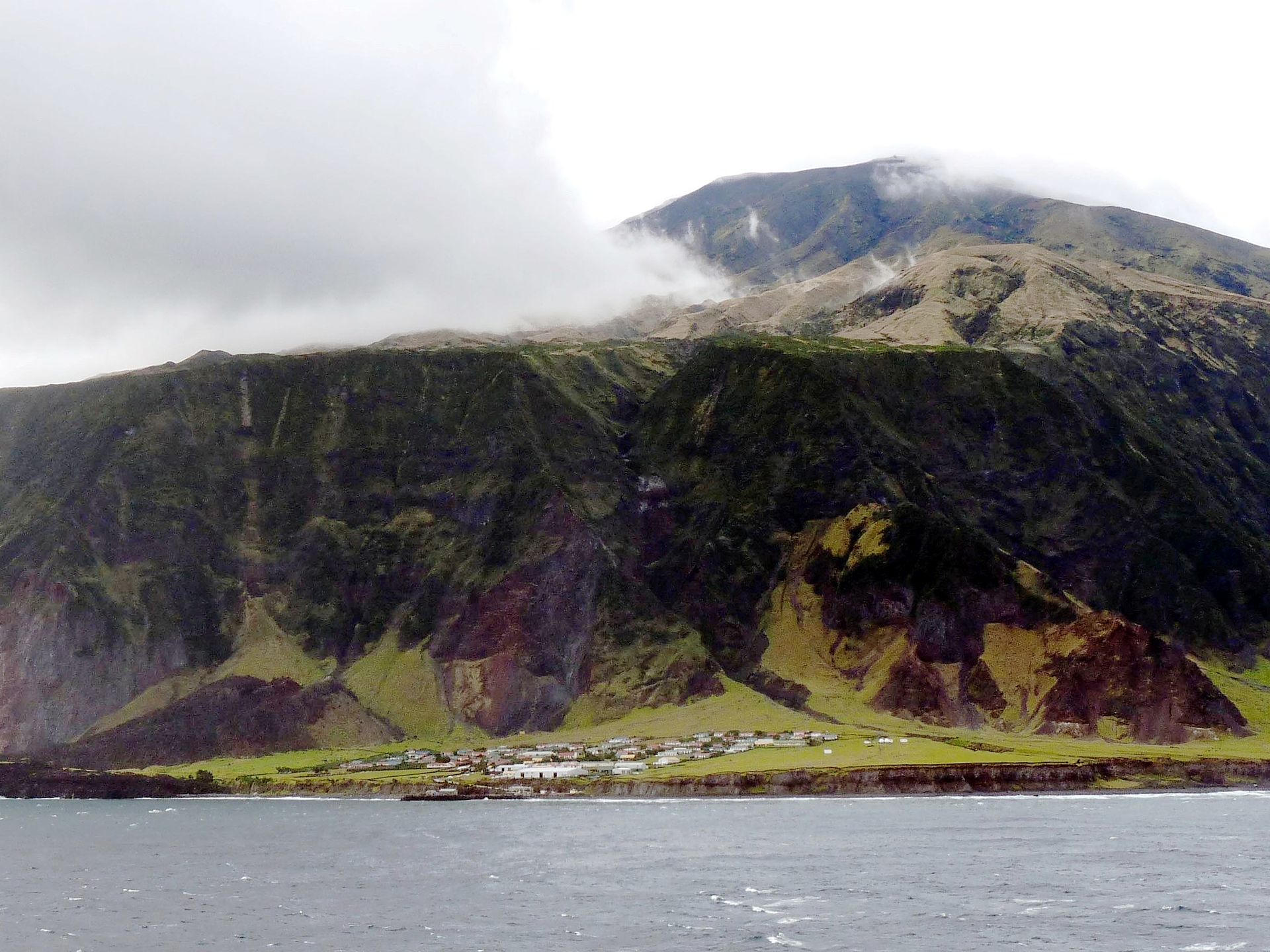
Edinburgh of the Seven Seas, Tristan da Cunha. Source: Wikipedia (Photo by Michael Clarke)
Mountains
It is all about mountains. The central peak at Tristan da Cunha is just over 2 kilometer high – and it is only 5 km from the coast to the peak! The peak is called Queen Mary’s Peak – there is a definite royalistic flavour to the local culture. Is that perhaps because of that visit by Prince Alfred? Inaccessible Island is a flat-topped mountain, about 450 meters high. The flat top is in part a peat bog. Nightingale Island, in spite of its small size, has two peaks. The highest peak is 370 meter tall, and the other peak is like a smaller version of Inaccessible Island.
The archipelago is sitting on an ocean floor that is relatively young and ‘only’ 3.7 kilometers deep. The young age is because it is only 400 kilometer to Mid Atlantic Ridge where the floor was laid. At a spreading rate of 1.1 cm/year, the ocean here is only 40 million years old. It hasn’t fully cooled yet and the lower density of warmer oceanic crust means it sis higher than the standard depth of old oceanic crust which is about 6 km. Still, this makes the three peaks between 4 and 5.5 km tall: these are substantial mountains! Below the sea, Tristan da Cunha and Inaccessible Island are the most extended mountains. Nightingale Island is smaller. There is a fourth would-be island to the southwest, a seamount that didn’t quite make the surface. It is called Rockhopper Seamount.
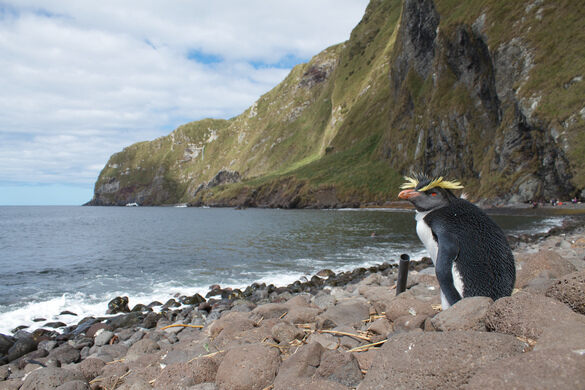
Inaccessible Island and a flightless inhabitant
They are active volcanoes. That is of course not a surprise: all deep-oceanic islands are volcanic. They are not highly active: don’t expect an Icelandic eruption rate; we are not talking Mauna Loa here. But they do erupt. Tristan da Cunha is a single volcano: a circular island with the peak at the centre. It looks young. The other two are far more eroded and look old and worn-down. Nightingale Island in particular is only a small remnant of its past.
Dating of rocks on Tristan da Cunha has confirmed the young age of this island. The shield-building era appears to have been around 100,000 to 200,000 years ago. There has been activity since: the summit area has shown some ages of only 20,000 years. This is assumed to be the most recent eruption of the peak. Other samples were even younger: the low bench on which Edinburgh of the Seven Seas is situated contained lava erupted only 10,000 years ago. It appears to have come not from the summit but from a parasitic vent on the side of the mountain. Older lava around the town has the same age as the summit eruption.
The bench (or the settlement plain) sits around 10-15 meters above sea level. The steep cliffs behind it are likely cause by erosion, probably during the interglacial 100,000 years ago when sea level was at times a little higher than today. The bench itself may have formed from later eruptions at sea level as the volcano transitioned from central eruptions to flank eruptions.
Tristan da Cunha shows many tephra layers among wet-land sediments. This has been interpreted as a series of ash-rich eruptions during the holocene, continuing to the present day.
Nightingale Island has been dated to 18 million years ago, an age half that of the ocean floor it sits on. It formed closer to the spreading centre itself, before being carried away by the ocean floor, but the island was never on the spreading centre. The extensive erosion shows that it has long been volcanically quiet. However, it is not extinct. There are younger deposits as well. Some lava have reportedly been dated to 100,000 to 400,000 years ago but these data are not published and need confirmation. One layer of ash was dated to 370,000 years ago. The youngest deposits (as far as known) are on a raised beach on the south coast. It is a complex deposit, with a layer of tuff at the bottom, a lava flow above this, and a topping of bedded ash. It is interpreted as an explosive eruption followed by a lava flow, a quiet era wit some erosion, followed by a repeat. It may have come from a cone 400 meters distant. Plant material in the tuff was dated to 39,000 years ago. A series of four ponds on the island may be craters: they have been dated to 20,000 to 40,000 years ago. It appears that the island has continued to erupt – but not very frequently!
Historical eruptions
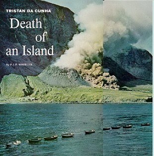 1961 was the year that Tristan da Cunha came back to life. Earth tremors began to be felt in August and continued daily for two months. The locals were concerned but did not expect that an eruption was brewing, for lack of any historical eruption. On October 8, a 200-meter long rift appeared in the ground, near the town. This was worrying.
During the night of October 9/10 1961, a lava dome began to grow. This was only 300 meters from Edinburgh of the Seven Seas! The done grew 100 meters tall, until after a few days the sea-facing side began to slowly collapse. Lava began to flow from the collapsed side, along the edge of the settlement; where it entered the sea, the flow front widened to about 1 kilometer cutting off Edinburgh of the Seven Seas from those seven seas. The flow temporarily ended in January 1962, but now a new lava dome grew within the flow field. It reached about 30 meters high. In March 1962 all activity ceased.
An eruption almost inside a town is a major event and this one even happened in UK territory. The UK government swung into action. Luckily the local people did not wait for that. They decided to take to their boats and evacuate to the only place they could reach: Nightingale Island where they spend a difficult night. A Dutch ship that happened to be passing came to the rescue: the following day it took everyone on board, to Cape Town. On October 12 the Royal Navy arrived to find an erupting volcano, and everyone gone. They collected the people’s belongings instead. From Cape Town the people were taken to England. Two years later they decided to return to their own Edinburgh. The town had survived and although a local factory was destroyed, the people (including four new additions by marriage) managed to restart their lives under the shadow of their own, living volcano.

The landing party from the frigate HMS LEOPARD (in the background) arriving on Tristan Da Cunha: © IWM. Original Source: http://www.iwm.org.uk/collections/item/object/205164546
This was probably quite a typical eruption for Tristan da Cunha. There are more than 30 similar small cones on the island and they may have formed in such eruptions.
The composition of the lavas indicate that the main magma storage is at the Moho, the transition between the oceanic crust and the mantle which underneath these islands lies at a depth of around 19 km. The crust underneath the islands is thicker than that of the surrounding ocean. The temperature of the magma chamber is around 1250 C. The melting happened much deeper: around 60 km which is the top of the lithosphere. This melt percolates up through the upper mantle and collects at the Moho. From here it again moves up: the magma evolves in the lower crust, between 10 km and 6 km of depth, where there is another, smaller magma storage facility. The eruption was fed from this depth. La Palma and Reykjanes operate very similar to this, although their magma is much more fluid than that of Tristan da Cunha. Their larger supply means magma spends less time cooling with much faster transport from lithospheric depth to the surface. Tristan da Cunha is a considerably less energetic volcano.
Nightingale Island played the role of an uncomfortable but safe haven for the 1961 eruption. But history repeated itself and this time it took a more prominent role. On the night of July 29/30 2004, an earthquake swarm was registered in the archipelago. The largest events were four earthquakes of M4.8. The swarm was felt by many people on Tristan da Cunha who were concerned that ‘their’ volcano (the new cone) was restarting. The swarm was detected by the Commission for the Comprehensive Nuclear Test-Ban Treaty Organization, who were of course monitoring for eruptions of another kind. The commission had installed two hydro-acoustic stations on Tristan da Cunha, which included seismographs. The seismographs showed that the swarm was located not under the settlement but some 30 km south or southeast. That placed it in the vicinity of Nightingale Island.
The swarm lasted 8 hours and occurred at a depth of 30 km. The depth already indicated this was not a tectonic swarm but volcanic in origin. This depth is in the upper mantle which is too ductile for rock-breaking. The swarm ended but the earthquakes continued. They declined until August 3, but some activity continued until December.
The hydro-acoustic stations also operated an actual hydro-acoustic receiver (or hydrophone array), moored on the bottom. This placed the activity to the east of Nightingale Island. Over the next days pumice began to wash up on the east shore of Tristan da Cunha. Later fishermen reported pumice all around the island with blocks as heavy as 10 kg. This lasted into August, and indicated a submarine eruption had happened.
The location remained unknown until bathymetric mapping was done by Geissler, published 2 years ago. They found that there was a previously unknown seamount, due south of Tristan da Cunha and due east of Nightingale Island. The mount reaches to within 300 meters of the surface and has the appearance of a young stratocone. This is assumed to be the source of the eruption, being at the right location from the earthquakes and the right depth for the pumice. The new cone is called Isolde, celebrating the medieval story of the love between a Cornish knight (Tristan) and an Irish princess Isolde.

The fact that it took 15 years to uncover the real culprit shows how little we know about oceanic islands. We only see what is above the surface, not what lurks below. The 2004 eruption wasn’t from Nightingale Island at all, neither on-shore nor its submarine flanks. Instead it came from a nearby, unknown submarine volcano. While Nightingale Island was in the open, the true volcanic singer, the real Nightingale, was skulking under water, by matter of speaking hiding in a marine scrubland.
Walvis Ridge
The archipelago lies near (or just beyond) a undersea ridge which extends from here to near the coast of Africa. It is called the Walvis Ridge and has the appearance of a hot spot track, but without the series of volcanic islands one might expect.
The ridge first formed on the Mid Atlantic Ridge (MAR for short), the spreading centre of the Atlantic ocean. The Walvis Ridge also has about the same age as the ocean, 135 million years, as can be seen from the fact that it extends to Africa. There is another track on the American side of the ocean, called the Rio Grande Rise, with a chain of seamounts extending towards Rio de Janeiro. Connect the two lines, and they meet at the MAR. They are clear two sides of the same coin. There is history here.
The traditional explanation is that a hot spot created seamounts and lava plateaus, and that the plates carried them away. The spot was active during the early Southern Atlantic Ocean and was located on or near the MAR. But this did not last: neither track runs all the way to the MAR. The hot spot disconnected from the MAR about 80 million years ago. The Rio Grande Rise is inactive: it lost the hot spot. The hot spot moved to the African side. It is now located at the western end of the Walvis Ridge: the Tristan da Cunha archipelago.

The hot spot is not what it used to be. That is already clear from looking at the Walvis Ridge. It is much more pronounced close to the African coast. There is a north-south jump in the ridge with the biggest bump at the location of the jump. After that, the chain get less pronounced and almost peters out before it reaches the Tristan da Cunha region. The hot spot was far more active 100 million years ago than it is now. It is dying.
But in its young days, it was something. This was the hot spot that formed a flood basalt still visible both in Brazil and in Namibia. It is called the Paraná-Etendeka traps, where the first name covers Brazil and the second part Namibia. (The Etendeka traps extend into Angola as well). When it first formed, there was no Atlantic Ocean. The traps initiated the spreading of an ocean, splitting a continent. There was no single event that formed the Atlantic ocean: it formed in stages, south to north, over almost 100 million years. But an important part of the process started here. The hot spot arrived, broke through the thick crust and formed a rift.
The Tristan da Cunha archipelago the last phase of this process. The hot spot is dying. But what a history. The song of Nightingale Island still thrills.
Albert December 2022
This post is based in part on Geissler, W.H., Wintersteller, P., Maia, M. et al. Seafloor evidence for pre-shield volcanism above the Tristan da Cunha mantle plume. Nat Commun 11, 4543 (2020). https://doi.org/10.1038/s41467-020-18361-4


Thanks Albert!, and No Island trail because that hotspot is so weak, and the seafloor is moving too slow for that there. Only very strong hotspots on a fast moving seafloor, like Hawaii will produce a island trail above sealevel after the erupting island. Tristan Da Chuna is a weak magma source, and whats the temperature of the astenopshere there? Normal Astenosphere is at 1280 C and is somewhat warmer at the ridges.
The emperor looking trail behind it, suggest faster moving seafloor at younger atlantic times and perhaps a more vigorous mantle source
The lava indicates a temperature of 1250C at the bottom of the crust, as mentioned in the post. Note that magma is a little cooler than the surrounding mantle because of the energy needed to melt the rock. Move along the Walvis Ridge and you find indications for higher temperature. At the time of the flood basalt, it was around 1400C. The hot spot has been steadily cooling and is now almost (entirely?) non-existent. The map does not conclusively prove that the islands are part of the hot spot trail. They are a bit behind and offset. The lava though has similar composition. But the islands are also along the line where the MAR would have been had it not jumped west: you can see it lines up with the MAR further north. I was wondering (but did not write) about a possible weakness in the oceanic crust at this location.
Thats right Tristan Da Chuna is a dying Hotspot .. Thats also why its magmas are so very alkaline. The 2004 magma was a Phonolite Thats a evolved basanite:
And Hawaiian plume Maybe 1650 to perhaps 1720 C is possible again now with a sourge in supply after Oahu formed. Puahonu formed by 1720 C ! But that plume is a monster compared to Tristan.
Many Plumes are core boundary in mantle tomography, but the depth seems not co – operate with a plumes strenght. Canaries are core boundary yet a very weak plume, while Hawaii is core boundary and insidiously strong and powerful.
I think its the speed of the mantle rock moving upwards and later melting that dictate how powerful a deep mantle plume is, for Hawaii and Iceland that is very fast how fast materials are rising in the plume channel, and you gets alot of materials that decompress melt, a fast plume channel flow dont cool much either, that explains why Hawaii is super hot.
A slower plume flow in the mantle yeilds less intense and deeper decompression melting and you gets the sluggish activity in Canaries and Cape Verde that are deep plumes too in tomography of them.
But tomography does not resolve the plume channel only the hot areas around acossiated with the mantle plume.
Well not all plumes are core boundary, but those that are all varies enormosly in strenght, so haves to do with the speed materials are rising upwards in the plume channel
Still at 1250 C the deep magma in Tristan will be a highly fluid melt, in TAS drill core diagrams its a Basanite as base magma. The 1961 eruption was a trachyandesite and 2004 was Phonolites indicating diffrent formation depth of magmas or enrichment in potassic elements prior to eruptions. The historical eruptions have all been stoored evolved stuff
All freshly melted magma should be fluid. The viscosity increases afterwards as the magma cools and evolves, and partly crystalizes. It is possible to have a low temperature melt which is fluid, if it was melted at that temperature.
Some interesting quakes at Mýrdalsjökull! While I am not too fond of the recurring hysteria around the ice quakes each autumn, these are actually deep intrusion-ish quakes, nice to see & one to keep an eye on in the next weeks / months.
Now on to the new article, thank you Albert for the nice Sunday-evening read!
Fascinating ! Thank you !!
FWIW, there’s a nice article about current unrest at Alaska’s Pavlov volcano ‘group’, including remarkable aerial footage of a 2007 lahar. ‘Gotcha’ is that, despite being really, really remote, Pavlov & Co routinely erupt ash across the air traffic ‘Great Circle’ fly-way, requiring wary diversions…
https://geology.com/volcanoes/pavlof/
Beautiful and interesting post! I allways get an urge to travel and see the places you describe. Thanks Albert!!
And on Iceland. First a swarm northeast out in the sea. Never seen that before during my 15 years observing. What could be the cause?? Far away from the spreading lines and hot spot center. Then the swarm under Myrdalsjökul with some deep quakes…. Hawaii, Chile…. So much to keep an eye on. Let us hope we do not get any big ones. We do not need any cooling eruption this year!
Yes, those deep quakes under Mýrdalsjökull makes it a bit more interesting. A lot of people seem exited about the many shallow quakes this year, but, as we have learned, those are probably due to the warm autumn and more glacial melt than usual. The deeper ones however are more likely to be related to magmatic processes, so well worth keeping an eye on.
The swarm to the northwest is considered to be intra plate quakes, not related to any known faults or volcanism. Páll Einarsson gave a possible explanation in an interview with mbl.is: They could be caused by a strain differential due to the different cooling rates between the thicker Icelandic crust and the normal oceanic crust outside the continental shelf.
Katla have not erupted for a long time now and been little or No inflation over these decades. I think that the volcano may not be receiving much magma at all these days. Katla is a powerful and very capable volcano, similar to large rift calderas in Africa or even some subduction caldera volcanoes like Okmok.
But for moment there seems To be No magma supply to its shallow system
https://www.researchgate.net/profile/Lisa-Rose-Jepson-2/publication/335404576/figure/fig7/AS:796241751470094@1566850235972/TAS-plot-for-Tristan-and-Inaccessible-Island-magmas-data-compiled-and-plotted-from-Baker.ppm
TAS for Tristan so its quite alkaline, the base parent magma seems to be alkali basalt or basanite, but thats right generaly very much more alkaline than say Hawaiis main magmas
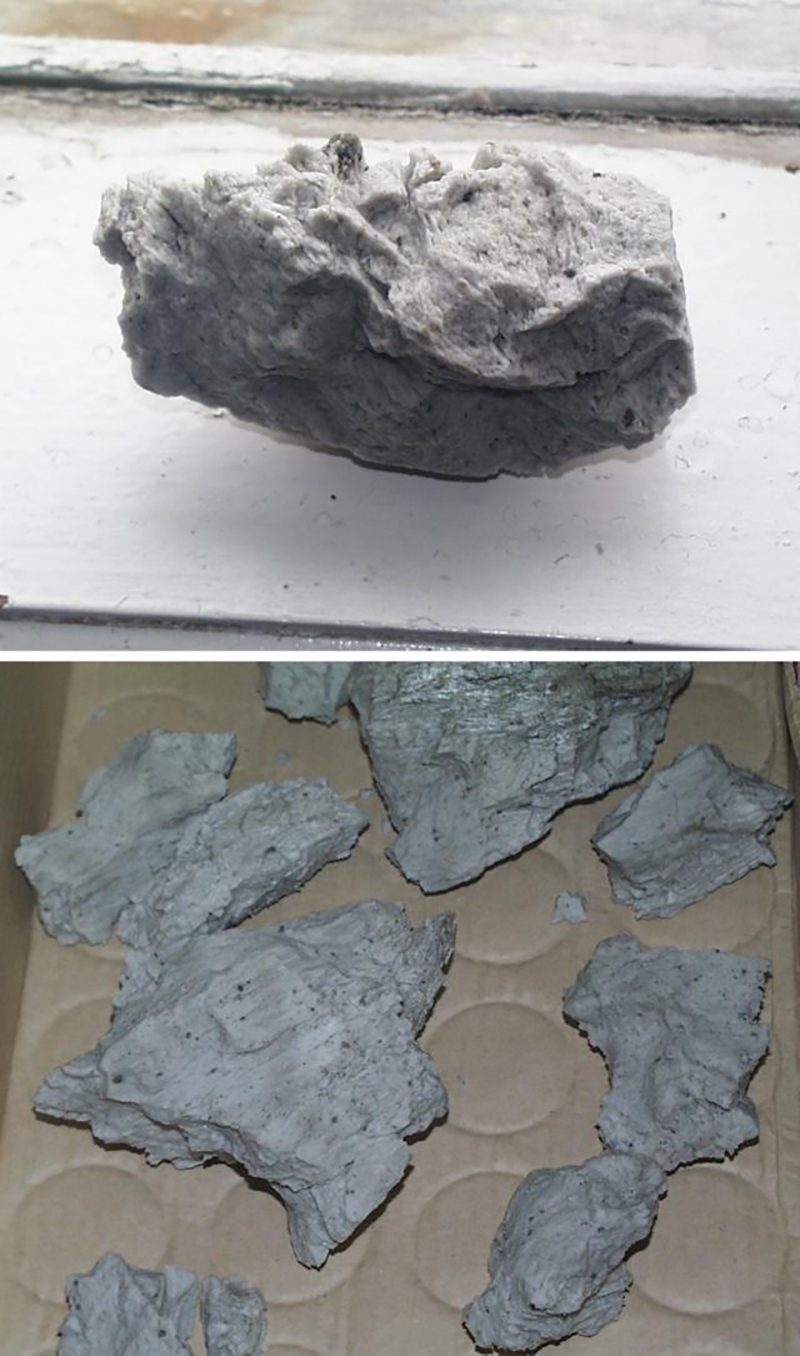
The 2004 eruption produced phonelite
Yes thats the evolved offspring of a Basanite, Phonolites are grey green or blue green .. strange rocks. Its the same type magma that Erebus have as well. 2004 Phonolite was white greyish and looked like laundry chemicals
2004 Phonolitic Pumice
Pumice blocks woud make great furnace insulation
Spectacular rapid Mauna Loa inflation during the first ~8 days after the eruption ended as seen in cross-caldera extension. Both the tilt and the caldera extension point to a rate of inflation about 7.5 times the typical inflation rate of Kilauea in between eruptions. A supply rate of possibly around 30 m3/s into the shallow magma chamber of Mauna Loa. This surge has decayed substantially. Right now inflation is “only” twice as much as Kilauea, and maybe even less in the past day, judging from tilt. This surge has resulted in the very rapid recovery of 1/5th of the volume that drained into the eruption and dike intrusion.
Seems like a very exceptional inflation. The cross caldera extension suggests an even bigger fraction than 1/5th of the total deflation may have been recovered, and considering the eruption is most likely about 90 million cubic meters, and that the dike can be very conservatively estimated in around 12 million cubic meters, then it is a very substantial volume that has been recovered in a matter of days after the eruption. 30 m3/s might even fall short. And the rate decayed exponentially, being much faster in the first 3 days after the eruption than in the following days. A deep reservoir rapidly resupplying a shallow reservoir seems like the most likely explanation to me.
Are you sure it is re-inflation? The GPS only show deflation by about 30 cm followed by stability. There is no recovery. The plot actually shows the length across the crater. This was declining and now is increasing again, but without any upward motion. From the MLSP GPS it looks to me like the south flank of the summit may be moving a bit south (or the north flank a bit north). Why is not clear – but there is no indication of any inflation. We would need an insar measurement to see what is going on.
I hadn’t seen MLSP, you’ve got a point. MLSP does not show inflation. Although the MOK tiltmeter does show tilting of the ground away from the summit, so there it does look like an inflating signal. And when a caldera extends so rapidly there must be some magma doing it. But maybe the signal is more complex, deflation in part of Mauna Loa inflation in the other, maybe combined with slip? InSAR would help yes.
The amount of deflation indicates that some 0.01-0.05 km3 of magma has been erupted. It is pretty hard to estimate from only two(!) measurements but this is what I get.
HVO have got 230 million m3, 0.23 km3 of lava erupted, which is more than 1984. I cant see how though, the flow field is smaller than 1984 and also took longer to flow its maximum distance and on a steeper slope, hinting at a lower effusion rate. Maybe they are using bulk, and the magma was particularly frothy on eruption (high SO2 may support this).
The amount obtained from the deflation may not include the lava erupted within the summit crater! That could explain the difference
https://m.youtube.com/watch?v=JrBgXA8tjGY
Video from the ongoing Etna eruption
And Live over the current Etna eruption making a tube system enjoy https://m.youtube.com/watch?v=ucUmOZo5srI
For Jesper, the Pu’u O Keokeo lava shield. The lava field is 300 km2 in area, so even at the conservative 1 meter thickness it is 3 km3. In reality the flows are way thicker, the main Keokeo flow with the massive tubes is up to 30 meters thick, perhaps 20 on average, which is a value that is similar to the flows on Pu’u O’o in places except this is over a much larger area, this flow on its own covers 60 km2 so contains at least 1.2 km3 of lava by itself. Other flows from the earlier stages of the eruption seem to be a little thinner but still 10 meters thick, an additional 2.4 km3. The volume of lava that entered the ocean is unknown, but given how robust the tube system seems to have been the volume may well be a considerable amount of the total, a lot more than the percent for Pu’u O’o. At 30% an additional 1 km3 is added for example. A total volume of 4 km3 seems at least very plausible. If the volume offshore turns out to be more like that of a fast eruption than a slow pahoehoe eruption though, where more lava is offshore than on land, then the volume could be double this figure.
The Ohohia flows are likely between 2 and 4 km3 on their own, given the characteristic ridged a’a surface that only really forms on a’a flows that inflate to tens of meters thick, like in 2018, and the massive lava delta that is visible beyond. I am not going to try and estimate the lava delta but it is probably alf of the whole flow by analogy to 2018.
The volume all up is probably between 8 and 13 km4, 11 km3 perhaps is an average. The tubes are as much as 18×11 meters wide, enormous, a 10×10 tube can carry 100 m3/s effusion rate at a flow rate of 1 m/s. Tubes are usually only 1/3-1/4 full or so, but also flow a lot faster too. At 100 m3/s this eruption would have lasted for about 2 years. The last flow was probably erupted at at least 1000 m3/s and in a few months. The vent itself was probably a massive violently bubbling lava lake, and at first was probably a powerful lava fountain, only that the eruption lasted long enough that the outflow channels roofed over while the fountain was ongoing.
🙂
So not quite a Laki, but very close.
Show me the location of the Ohohia flows … wants to inspect them in Google Earth
Green outlines are younger flows that cover it. So shape is a little bit speculative but should work.
https://www.usgs.gov/media/images/mauna-loa-1975-eruption
Nearly 50 years apart, but in the same place. 🙂
https://www.volcanocafe.org/wp-content/uploads/2022/12/vhp_img4265.jpeg
image removed and replaced with one with a slightly more acceptable size. Please don’t put 10Mb-size pictures here. There is no reason to do so. – admin
Which begs the question–will 2022 be considered a summit eruption, the same as 1975?
No fissures 3 and 4 were further east, in the same area as the 1899 and 1881 eruptions. What is in that photo is fissure 2. I guess fissure 1 is the massive curtain of fire that opened across the whole summit at the beginning.
Looks like this morning’s M6.4 epicenter was strike slip about 5 miles offshore on the Ross Fault Zone NE of the Mendocino Triple Junction and SE of the southern tip of the Cascadia Megathrust Zone, but curiously the aftershocks are tracking mostly to the NE tangential to the strike of the offshore Ross fault…so it’s possible that other splay faults may have been activated by the main shock as well? Also, within the last hour, a M4.2 aftershock just occurred on the Pacific side of the main CSZ. Let’s just hope that the southern segment of Cascadia isn’t getting any ideas about making a move (which would be vary, vary bad)…but so far, all the activity is apparently strike slip (and somewhat deeper than usual at around 16-18km). It worth noting that this southern segment of the CSZ has the highest probability of letting loose in the nearterm, so any quakes of this size and vicinity are always cause for some concern.
Local news is showing extensive damage to the coastal areas mostly in Humboldt county, with power outages now totalling in the many tens of thousands, with over 70,000 now without power in Humboldt County alone. No word on injuries just yet.
Shake Alert woke me up at my place about 120mi from the epicenter, then minor shaking started about 15 sec. later which lasted for about 5 sec in duration.
Fun thought. Lassen Peak, which Albert talked about a couple weeks ago is ” rel=”nofollow ugc”>directly east along the line of the Mendocino Fracture Zone from the location of that earthquake. Interesting if the earthquake added a bit of pressure to the Lassen magma reservoir.
(Re Albert’s article, which is fascinating, I should add that my icon is of a pied butcherbird, a species known here as a “magic flute”. I’ve never heard a nightingale but the pied butcherbirds in my area sing like angels. Newcastle fortunately isn’t at all volcanic although we had a moderate intraplate earthquake in 1989.)
Oops, the Mendocino Fracture Zone graphic didn’t work. But you’ll see what I mean if you search for the wiki.
https://www.youtube.com/watch?v=JrBgXA8tjGY
Etnas current eruption
And a webcam of it https://www.youtube.com/watch?v=ucUmOZo5srI
opps reposted
Current aftershock activity shows two new minor shocks very near the CSZ on the E (North American Plate) side. While in itself the shocks are puny, it does suggest that some stress any have been transferred westward from this morning’s main shock to near the southern segment of the CSZ?
https://earthquake.usgs.gov/earthquakes/map/?currentFeatureId=nc73821646&extent=39.17266,-127.80945&extent=42.13082,-122.88757&magnitude=all&listOnlyShown=true&showUSFaults=true&baseLayer=street&timeZone=utc&settings=true
Fagradals had a little cough just now. 3 reasonable dry cracks at around 4km down, one at 3.1.
No sign of anything moving up, But I wonder if we may start seeing more rock cracking before long? A spring eruption?
There have been intrusions about every 3 months on Reykjanes for a while now, except for during the time of the eruption last year.
March 2021 (eruption)
December 2021- January 2022
March 2022
May 2022
August 2022 (eruption)
Also a number of intrusions a bit less regular in the couple years before 2021, beginning really in January 2020 under Thorbjorn. I dont know how many exactly, but since 2020 there have been distinct intrusions under Krysuvik, Fagradalsfjall, Svartsengi and Reykjanes volcanoes, with two eruptions from Fagradalsfjall. So magma supply to the area is very high at the moment probably more than anywhere else in Iceland right now. All of the above volcanoes are probably going to erupt in the next few years to decades, Fagradlasfjall has an active rift so is the most likely option while inflation still happens in the area, but there was also a lot of surface cracking near Grindavik in August so the next intrusion there might get interesting…
The most recent 3+ quake though, is actually from Krysuvik, right south of Kleifarvatn. So really, all of them are going together, it could be a bit of a wild card which one actually erupts next. But considering there were two eruptions and at least 5 intrusions in 2 years if there is not an eruption in 2023 I will be a bit surprised 🙂
That’s over at Krýsuvík, the next system. There was a triggered M5 quake along the same fault line in august, during the runup to the latest eruption. This could be an aftershock. No activity at Fagradalsfjall at the moment.
Is there something going on beneath Italy at the moment? I am not talking about the usual suspects.
Over the past two weeks there seems to be a cluster of quakes in the Adriatic near San Marino.
And a line of quakes running down the mountain range, through central Italy.
https://www.volcanoesandearthquakes.com/map/Italy
https://www.emsc-csem.org/Earthquake/Map/zoom.php?key=1&typ=world#5
Thanks to your reference to San Marino, a place I’d heard of but wouldn’t be able to point to on a map, its location is now loosely sketched onto my mind’s image of the world. VolcanoCafe is always great for that.
thank you for yet again amazing article.
I can’t stop myself thinking about Azores a bit higher on MAR.
Tristan’ hot spot produced prodigious amounts and took 100M years to start dying. Azores uplift is 36M years old, area is above sea level only 8M years and the place is so complicated nobody can even agree what is going on.
Not every plume meets a triple junction.
And not every hot spot is the same. A ‘hot spot’ just is a warmer region. It does not say where the heat comes from. A flood basalt needs more heat than an oceanic island and likely needs a different source of the heat. Composition of the mantle and crust is important: some ricks melt more easily than others. As for life times, 100 million years seems reasonable. A deep plume would take 10-20 million years to reach the surface and presumably a similar amount of time to die down again. If heat can be removed from the top, mainly by moving plates, the plume could be stable for a longer time. If not, the top heat will eventually stop the plume from rising. The Azores are in a region where the plate movement with respect to the mantle is quite slow.
For a shallow plume, conditions are probably quite different.
There was a mag 3-4 quake 10 km deep under the SWRZ of Kilauea in the past day. Not iften that anything occurs in this area, its a silent zone between Kilaueas summit and the Pahala swarm. It is possible this is something to do with Mauna Loa as the depth is where both volcanoes can play a part, it might be a decollement fault quake. But thise are usually on the south flank of Kilauea, not inland, and the decollement quakes triggered by Mauna Loa are usually under its own flank not this far east under Kilauea.
Maybe it is related to magma movement within the crust, below the decollement fault. Its position between Kilauea and the Pahala swarm then could prove very interesting…
And now there are swarms if quakes happening to the immediate south of Kleifarvatn, where there was the bigger quake recently. Just aftershocks but we all know how that can change in this area…
Never been able to get data on what exactly causes these quakes. Early on it was proposed these sre stress quakes highlighting magma at Fagradalsfjall but the same was said of the quakes at Grindavik which are now known to be an intrusion of their own.
Not long now 🙂
Holy cow, look at the deformation on ML’s upper NERZ!
https://www.usgs.gov/media/webcams/m8cam-mauna-loa-northeast-rift-zone-fissure-3-live-view
Slightly off topic, but evidence indicating potential for a large Martian mantle plume: https://www.sciencedaily.com/releases/2022/12/221205121545.htm
https://www.washingtonpost.com/science/2022/12/22/hawaii-volcanoes-magma-chambers/
https://twitter.com/SquigglyVolcano/status/1606002980477579266
Dr Robin George Andrews 🌋
@SquigglyVolcano
NEW: By feeding 192,000 quakes to machine learning programs, scientists from @CaltechSeismo
have made a stunning discovery: there is a colossal magmatic heart hiding beneath Hawaii, one that beats as its chambers fill with magma!
https://www.science.org/doi/10.1126/science.adf2993
https://www.science.org/doi/10.1126/science.ade5755
Paper
https://twitter.com/SquigglyVolcano/status/1606003031002193921
Oh good someone already linked this 🙂
It is like Pahala is a massive magma reservoir and Mauna Loa and Kilauea are two satellites
A series of HUGE stacked sills, does it contain many 100 s Maybe 1000 s of km3 of magmatic melt.?
Very interesting article. It is mostly great. Although I do have some problems with their purported Pahala-Mauna Loa connection. They make no mention of the LP earthquakes that take place 45 km deep directly under the summit of Mauna Loa. There was a massive swarm of such deep LP earthquakes in 2004-2005. In the USGS catalogue these are located deeper that Pahala seismicity.
So the most reasonable pathway feeding Mauna Loa is vertical to a depth of 45 km, below Pahala. Instead, their Pahala connection leads straight into the decollement of Mauna Loa above the Pahala Swarm, in the general focal area of the 1868 earthquake. This location is extremely faulted but has not shown seismicity linked to pressurization of Mauna Loa’s shallow storage in recent decades, so it seems unlikely a conduit could go across that area and into the summit of Mauna Loa. This in turn casts some doubt in the ability of their deep learning algorithm to place correctly LP earthquakes.
Héctor, do you think the connection between the two volcanos that you spoke of here https://www.volcanocafe.org/kilauea-i-magma-waves-from-the-phantom-rift/ is below 45 km?
In this other article I gave a more recent view in what I think about the plumbing under the volcanoes:
https://www.volcanocafe.org/kilauea-iii-rifts-under-hawaii/
I do think there is a connection between Kilauea and Mauna Loa, but probably at ~45 km or deeper.
I personally don’t think that Pahala is a magma conduit in itself, most likely a system of faults reacting to nearby intrusion complexes. The following map shows earthquakes 42-35 km deep under Hawaii:
I interpret these earthquake zones as decollement faults, similar to the main decollements at ~10-7 km depth. These deep decollements seem linked to the volcanic structures, they encircle Hualalai and Mauna Kea for example. The main band of earthquakes under the south coast of the island, including the Pahala Swarm, seems to be the deeper equivalent of the ~10-7 km deep decollement under the south flanks of Kilauea and Mauna Loa that ruptured in 1868. So Pahala is likely, in my opinion, a fault complex that is somehow linked to deep rifting, down to 50 km depth, under Kilauea and Mauna Loa. The deep LP earthquakes under Mauna Loa extend also to 50 km depth and are probably important too:
Now since you said that, there might be a chance that the fault lines are acting like pipelines or taps, with some shutting off or another opens. Kīlauea, before the 2018 eruption, had some sort of supply source (I.e. dikes and sill compexes) that went on for so long that there are nearly no earthquakes in the area. After 2018, however, the faults lines light up, struggling to see which fault will be the dominant source, grinding, shutting and closing. It seems to have gotten a little quieter, and seems as if only a few “supply lines” remain until one dominates all. This is simply hypothetical, but this is what I have interpret it as.
It can be both of these things. There are obviously faults under Pahala to get these quakes in the first place but at this depth there will also be a lot of magma around. It is surprising that the mantle isnt plastic at these depths, but maybe the weight of the island squeezes the melt out into pockets and leaves more solid mantle, sort of like it is wet sand that gets compressed. Your hypothesis on the mechanism for the 1868 quake has made me think a lot about the interaction of magma with fault lines, the swarm under Pahala could be a similar affect but backwards, from a deep source rising into an existing but mostly dormant fault. It will probably not end until the pressure is released, which is to say the magma can escape into Kilauea, which might be a while or a long term process.
As for depths of the LP quakes under the two Maunas, both of them are really tall, their bases will be deeper down, the ice berg effect, 45 km is just below the base of the lithosphere under Mauna Loa. Kilauea is not tall at all, it pushes down much less, so the base of the lithosphere is shallower. The base of the lithosphere also will mirror the island topography very roughly, which is also what the swarm does, it is inward dipping towards the island.
In this location (Pahala), the magma could go directly up to form a new volcano. The reason that hasn’t happened is probably the steep slope of Mauna Loa. The gradient causes the line of least resistance to slope upward, parallel to the surface. But the decollement is depressed underneath Mauna Loa, so that goes the other way. It would make magma migration from that location quite difficult. So instead it expands in the most horizontal direction, which is roughly east to northeast. It seems to me that this location cannot easily feed either of the two volcanoes. It has difficulty, and therefore the decollement can collect magma until the pressure pushes the deeper magma in another direction. The earthquakes shows that it is currently not a stable magma flow
The pahala quakes also show that the enviroment there is supprisingly brittle, unexpected because Hawaii is a tremedously hot and productive source. Perhaps the high pressures at 45 km depth raises the melting point of the sourrounding litosphere and allows the formation of quakes there. The main heat source is a further 50 km down, below pahala
That could be why the eruptions today are not near those reported 1500+ C temperatures that exist in some old samples. Perhaps that is because the Pahala swarm is part of the long term transition of the plume to feeding Kilauea in preference to Mauna Loa. This is incomplete, as Mauna Loa still erupts often and is sometimes the more active of the two, but it is clearly past its peak. Kilauea is still yet to reach the stage at which Mauna Loa was in to grow to its present size and great altitude, it is a teenager where Mauna Loa is late middle aged.
One day the Pahala pathway will open suficiently that the hot stuff will erupt again. Given that the area is a sill complex this may be relatively close, or can happen intermitently at any time. The flare up is probably a reaction to 2018 but that doesnt mean the show is over, the volume of magma down there is far beyond anything lost in 2018.
Does the Pahala sill complex contain many 1000 s of km3 of stored magma ?
It probably has to, the area that quakes happen in at that depth is some 200 km2, and the total depth of the whole thing is at least 15 km and that isnt counting magma that is flowing towards Kilauea, where the path seems to be more open. 200×15 is 3000 km3.
I imagine that sills at this depth are probably not crystal free melt as they are at shallow depth, but given the considerable volume of magma that hawaii generates every year the melt fraction is probably very high, even at this depth it is probably over 30% and at shallow depths it is higher. So there is 1500 km3 of magma on the move per the above calculation. In reality there is probably way more, because Pahala is not the only source magma to the volcanoes. Kilauea on its own probably contains over 1000 km3 of magma ranging from the crystal free melt in the shallow magma chambers to olivine cumulate in the deep rift, and everywhere inbetween. Mauna Loas deep rift should be more voluminous, given it goes down nearly 20 km, although it has less shallow magma. Some other big plume volcanoes, like Yellowstone, and probably some parts of Iceland, have got plutonic mafic systems that are on the order of 10,000 km3 or more, so this is not exactly a novel idea although most volcanoes dont have anything even remotely comparable. In Hawaii it is a bit different as the deep rifts are still within the island, not in the pre-existing crust as they are in Iceland, so are maybe not correctly called plutonic, but it is otherwise the same thing basically.
Still though, given that the Pahala swarm represents a large accumulation of magma and this has got some actual degree of confirmation now not only just my wild theory 🙂
having this much magma around could mean activity picking up a lot at one of the volcanoes in the future. The swarm has expanded, which would imply that new sills have formed not just existign ones moving. And most of the expansion has been towards the northeast, skirting the deep base of the island and going towards Kilauea, and a lesser amount towards Kama’ehuakanaloa. They also shwo the connection to Mauna Loa but that connection not actually reaching the summit, so not sure of any real affect there.
🎄pop!
The christmas cano have awoken
Back in Iceland, the SAM tremor graph shows a weird signature around the time of small earthquake swarms on Dec 21 and 22. Does anyone have any idea of what this represents? The KRI graph doesn’t show anything special, even though its location seems to be closer to the earthquake locations.
Do you mean SAN? That station is Sandskeið, located by a small airfield right next to the main road. That station shows a lot of human activity, except earlier this week when a blizzard in practice had Iceland closed down.
Yes, it’s SAN. It looks like a test signal that repeats at midnight every day for 3 days so far.
Svarm on Kilauea
Today the Friedenslicht (light of peace) was brought to my house. It will light up my frontdoorstep during christmas.
I am wishing for a peaceful christmas to all of you! Merry Christmas!
friends from NZ prepared article about Taupo
https://www.geonet.org.nz/news/57MTzCQKttKtwXxAroUDbM
New post us up! Mary Poppins upside down
https://www.volcanocafe.org/the-green-green-lands-of-australia/
Thank you, Albert!
Tristan da Cunha has for many years now been one of the most fascinating places on earth to me, even before I got into volcanoes, and this article just makes it, apart from so much more exciting, also so much more volcanologic and scientific as well!
Love it, and hope to visit one day (if I’ll ever get the budget)!
Thank you for the nice message. I hope you will have the chance to have your trip of a life time one day! Your message was help back for approval by our spam demon, something that happens to all first comments. It is sadly necessary. Any future comments should appear instantly.