Each volcano is an expression of a magma architectural construction, a great sculpture of chambers, pipes and sills, as intricate as an ant colony, or rather like the roots of a plant. This is all hidden away from our view, under kilometres or tens of kilometres of rock that makes it impossible for us to know what lies down there, or perhaps not? To me a volcano is a puzzle of many aspects, geochemistry, earthquakes, structure and eruption behaviour, among others. A puzzle can only be completed by taking all the pieces and putting them together. Not an easy task. I will attempt to assemble the puzzle, or at least part of it, of my favourite volcano. Kilauea. And it all starts with a caldera collapse in 2018.
As I write this, three years ago the summit of Kilauea volcano in Hawaii was collapsing into a caldera. Its shallow magma chamber emptied laterally through fissures in its rift. It might seem like this was a while ago and is now over, but is it? The collapse set off a series of cascading consequences that are still rippling through the molten structures of Hawaii Island. The deflations of Mauna Loa, a swarm of tremor and earthquakes under the town of Pahala, the recent eruption of Kilauea, all might be connected and it has just barely started, I will argue how this all happened and how all the events would be related.
We should first know a little about the connections of Kilauea with Mauna Loa and Pahala.
Kilauea and Mauna Loa
These two volcanoes have quite an interesting relationship. When one volcano is more active the other is less so. In particular each takes over for a period of 100-250 years, during which it gets most of the magma supply in Hawaii, then this activity goes to the other. They share the same magma supply. A far as I know this has been going non-stop for at least 2000 years. On a future article I will talk more about this aspect.

Volcanoes of Hawaii Island. From USGS.
Kilauea was dominant throughout the 18th century and until 1840. 1840-50 was a transition decade. Mauna Loa was dominant from 1850 to 1950. And Kilauea from 1960 to present. We are currently in an era of Kilauea and there is still more than forty years to go.
This relationship is best seen in the supply and the chemistry of the magmas. While Mauna Loa was dominant it erupted every ~3-4 years at an average rate of 1.2 m3/second. The total supply would also include dyke intrusions and slow spreading which could increase the total number by a factor of two or so. After the 1950 eruption its eruption frequency plummeted spectacularly. Dormancy periods have been 25, 9 and 37+ years. The output was reduced to 0.11 m3/second, a difference of a whole order of magnitude!
Kilauea mirrors Mauna Loa but in the inverse way. When Kilauea erupted continuously in the 1840-1920 period it did so at a rate of 1 m3/second and there were practically no large dyke intrusions. In contrast when Kilauea erupted continuously after 1960, during the Mauna Ulu and Pu’u’o’o eruptions, it did so at a rate of 4.1 m3/second, four times greater than in the subdued state. Ever since 1960 Kilauea has been rapidly inflating, spreading, and erupting. It has produced over 6 km3 in this time. The most productive volcano in the world. Overall Kilauea seems to erupt more, but it is clearly impacted negatively when Mauna Loa is more active.

From USGS.
Both volcanoes must feed from the same magma reservoir at depth, and through some mechanism the supply to this reservoir goes to either one or the other. But where? And how? All will be answered, but will have to wait for future articles, lets first take a look at the Pahala Swarm.
Kilauea and Pahala
A swarm of earthquakes has been raging under the town of Pahala since 2019. Actually the swarm has always been there, but its earthquake rates have skyrocketed starting in January 2019 and rising to unprecedented levels. The earthquakes are 30-40 km deep. And there is the tremor. The area just offshore Pahala is an extraordinary source of volcanic tremors. Almost all deep tremors of Hawaii originate from this location and are thought to be caused by magma rising up from the depths. Pahala would be a magma conduit then. The swarm has two parts the southern, deep, offshore swarm of of tremors, and the northern, shallower swarm of fracturing earthquakes. These two distinct parts are important when looking at the post-2018 series of events.

Deep earthquakes August-October 2019, when the Pahala Swarm was starting to ramp up. From USGS.
The Pahala Swarm is thought to be the magma feeder to Kilauea. How could we know this? When looking at a map the connection shows up quite clear, the Southwest Rift of Kilauea, which runs straight from its summit to the swarm, providing a useful connection. However the Pahala earthquakes are very deep, 30 km, does the rift really extend down to here?
Hawaii has a peculiar tectonic system powered by the magma supply. The rifts and the decollement faults. A rift is like a fracture system that is opening up and filling with magma, when simplifying things down a lot. The rift pushes away the flank of the volcano to open up space for the magma. The flank creeps on top of a nearly horizontal fault that is slightly upslope, a reverse fault, this fault is know as the basal fault, the basal detachment, or basal decollement. Why basal? Because it runs through the base of the giant lava pile that is Hawaii. Here the volcano rests on top of the depressed ocean floor 8-10 km below sea level.

The flanks of Hawaii Island are moving like a series of blocks away from certain rift zones. Crustal decollement refers to the basal fault. Created in Google Earth.
Because Kilauea is the volcano getting most of the magma now, then it is in front of Kilauea’s main rift, the East Rift, where we see these processes in action. The East Rift is continuously spreading very slowly, pushing against the south flank which swells upward and contracts, being squeezed by the lateral pressure. This can be seen in action if one visits the data of the GPS stations that the Hawaiian Volcano Observatory is monitoring on the south flank. When the basal fault can hold no more it breaks. The fault can rupture in earthquakes reaching M 7.9, some of the most powerful volcano-tectonic earthquakes in the Planet.
With all the mightiness of the basal fault a second, more modest system is often forgotten. Which is this unfortunate fault? The Mantle Fault Zone. It is called this way because it runs at a depth of 30 kilometres, in the lithospheric mantle. It happens to be a nearly horizontal fault similar in many ways to its shallower, larger relative, it can produce earthquakes reaching up to M 5.2, but most importantly has a very particular slip direction, 137º clockwise from the north, exactly perpendicular to Kilauea’s southwest rift, and positioned is such a way that it would open up the line from Pahala to Kilauea’s summit, and at the perfect depth. To put it simple, the southwest rift extends down to the Pahala Swarm and could provide an effective pathway towards Kilauea. More evidence for a Pahala-Kilauea connection is seen in the events following 2018.

I should also say that the magma chambers of Kilauea are most of them aligned with the southwest rift. This shows when there are deep sources or deflation or inflation, one of the most common sources of deformation that shows up is an egg-shaped pattern that is centred just southwest of Kilauea’s summit, is aligned with the southwest rift, and has the long end pointing towards Pahala. The main caldera of Kilauea formed in 1500-1790, has its outer scarps rectangle shaped with its long sides running parallel to the strike of the southwest rift. Currently the main axis of the Southwest Rift runs more or less coincident with the southeast margin of Kilauea Caldera, making a nearly perfect N 47º E direction line, that is perpendicular to the Mantle Fault Zone slip, and connects the most primitive magma eruptions of Kilauea, at Kilauea Iki, and Keanakako’i Craters, and the December 1974 dyke which marks the main rifting axis of the rift zone. This is seemingly a little detached from what must have been its original position.

The “egg pattern”. From USGS.
There is yet another structure that links Pahala to the summit of Kilauea. The Kaoiki Pali. I think this pali, which means cliff, is none other than the rim of an large ancient caldera of Kilauea. Why? you may think. Because it hasn’t ruptured in over 9000 years. Fault-related scarps like those linked to the slumping or to the rifts rupture frequently over and over. Kaoiki Pali also wraps around the summit of Kilauea like other caldera faults do.
The formation of this structure happened at a very particular time. Kaoiki breaks the Pahala Ash layers that formed until 11,000 years ago, but is covered by 9000 years old flows of Mauna Loa. It formed at 11,000-9000 years. This marks the most important transition in the recent volcanism at Hawaii, where Kilauea ended a lengthy period of powerful explosive eruptions known as the Pahala Ash, and resumed summit overflowing. Mauna Loa went from a period of low activity to a period of very high activity, maybe even almost uninterrupted dominance lasting a few thousands of years. It was a big change. Kaoiki Pali could have formed if the whole complex of magma chambers and sills placed along the Southwest Rift of Kilauea collapsed. Which I think is the best, although perhaps not only, explanation.
After the 2018 eruption
Back to the big eruption. In 2018 Kilauea erupted 1.2 km3 of lava and its summit caldera underwent a nested collapse. An event on this scale had not shaken the island since at least the 1868 eruption of Mauna Loa, if not since 1790. If there was any eruption that could disturb the hellish furnaces deep under the mountains of Hawaii it would be now. What do I mean by this?
An eruption drops the pressure of a magma chamber by extracting magma from it, which may increase the resupply from the magma source to restore the pressure. It just happens that 5 months after the 2018 eruption ended the seismicity of the Pahala Swarm started ramping up towards record levels. The seismicity of the previously suspected feeder to Kilauea Volcano. So presumably it did react to Kilauea’s pressure drop.
First came the tremors. As I’ve said the Pahala Swarm has two parts, the tremor swarm at ~40 kilometres deep, and the fracturing swarm at ~35-30 km. The Pahala tremors tend to always start with a sudden jolt and then a series of later spikes, these can be located much more easily, like they were earthquakes, than other types of tremor.

The tremor came much stronger than usual in 2019. There were 4 pulses. The first pulse had its main phase in January 11-January 23. The second pulse peaked March 14-April 2. The third May 12-June 3. The last pulse came more dispersed in a series of peaks and could be considered more like a bunch of small pulses lasting from June 26 to July 27.
After the 4 big pulses the tremor activity dropped to the typical low levels until mid-2020 or so when a second series of strong tremor pulses started. I will focus only on the first series though. I do know however that there was at least one pulse in the second series, in January 2021, that does rival the 4 big pulses of 2019.

Characteristic Pahala tremor episode.
The fracturing swarm exploded into existence in August 2019. I remember being really impressed by this strong activity and yet this was nothing compared to what was to come. The rock fracturing of this type is thought to be volcano-tectonic, caused by an increase in magma pressure which shatters the rock around the magma. The Pahala Swarm started almost above the location of tremors. If the tremors were related to magma flow, then the fracturing may have been due to this same magma pulse pushing against the rocks on its way up.
The swarming initially exploded near Palima Point, and then propagated 10 km northeast, towards Kilauea, until it reached the opposite end of the Pahala Swarm, where I suppose the magma must have dived into the southwest rift of Kilauea. This happened around the time of peak earthquake activity on February 2020, when HVO was locating 80 earthquakes per day here. Unprecedented for Pahala. The levels then gradually dropped through the remainder of 2020. In 2021 earthquakes rates have started rising again and have nearly reached the levels of February 2020. The first rise August 2019-February 2020 seems to correlate with the first series of strong tremors, the second rise in 2021 seems to correlate with the second series of tremors.
Magma waves?
I was eagerly waiting the magma pulse to hit Kilauea. Perhaps a bit too impatient. It took more than a year for the pulse to move just 10 km up and 10 km sideways from the tremor area to the closest end of the swarm to Kilauea, it was obviously going to be a long wait! But finally something happened, not in the way or the place I would have expected however.
Mauna Loa got weird. Weird means that the volcano started deflating quite markedly with no apparent reason to do so. This was around October 20, 2020. Hawaiian volcanoes, and volcanoes in general, deflate when magma is removed from their magma chambers to feed intrusions or eruptions. There was certainly no eruption. I didn’t notice any intrusion either, and I think I would have noticed, or at least HVO would have. If magma wasn’t removed by the conventional ways, where did it go?

Mauna Loa deflates twice. Modified from USGS.

2nd deflation event. From USGS.
The next thing did happen where I was expecting the way I was expecting. On the morning of December 2 a sudden surge of magma hit the summit of Kilauea. It was quite dramatic. I had been following Kilauea since the 2018 eruption and not much had happened. But all of a sudden there was the fastest inflation I had seen, within a matter of hours the summit “broke”, a dike rose towards the surface but failed to erupt. Kilauea kept inflating, on December 20 it snapped again this time the dike intersected the crater of Halema’uma’u and started an eruption.
History then repeated again, Mauna Loa started deflating abruptly on March 23, 2021. Then on June 1 Kilauea set off in another episode of rapid inflation. It was time to write down the hypothesis.

Kilauea getting two magma surges. The first was responsible for the December 2020 eruption. The pause in supply that ended the eruption could be correlative with the pause in tremor activity seen in Pahala before the 2nd tremor pulse started. Modified from USGS.
Timing of events
What do we know? First, Mauna Loa and Kilauea share the same supply and must be connected at some depth somewhere. Second, a large amount of magma rose through the Pahala Swarm in a series of 4 pulses in 2019. Third, Mauna Loa and Kilauea each have been hit by two rare magma waves, producing inverse effects on them.
Here is what I think. There was a magma chamber which reacted to the 2018 eruption, this chamber is where Mauna Loa and Kilauea are connected. A series of magma pulses rose, each pulse sent two waves, a positive wave towards Pahala and then Kilauea, and a negative wave towards Mauna Loa. Why negative? With each pulse the magma chamber pressure would have dropped pressure, remember that pressure drops when it feeds an eruption or an intrusion. This is an intrusion. The pressure drops would have manifested eventually at the summit of Mauna Loa, which is apparently closer to the source because it was hit by the changes earlier. Basically it would have lost magma due to the 2018 draining of Kilauea needing urgent resupply.
Presumably each volcano has been hit by the first and second pulses of tremor that took place in 2019. There is one problem though, the distance between them seems to have changed. The first and the second came 62 days apart in the tremor region, 154 days apart as they hit Mauna Loa, and at 181 days as they hit Kilauea. This would suggest the second pulse is travelling slower than the first. It is possible that the speed at which the waves move could be slowing down. The depressurization wave created by Kilauea was the fastest to reach Pahala in 8 months, the first pulse took 23 months to travel the same route up, the second 25 months.
This makes predicting the arrival of the third pulse complicated. Assuming that the interval between the second and the third changes by the same factor as the first interval, the arrival of the wave can be estimated, though how accurate it may it be remains to be seen. It may arrive at Mauna Loa on August 17, and at Kilauea on November 20. The third could be the strongest if the number of tremors are a good indicator.
Conclusion
The 2018 eruption of Kilauea keeps giving new surprises 3 years later. It seems that it set off a series of waves that are rippling right now through the magma system under Hawaii, and might continue to do so for years to come. There could be a lot to learn from this. The third pulse could provide the final confirmation that Kilauea and Mauna Loa are connected through a magma chamber that feeds into Pahala, and it may also provide data regarding the properties of this connection.
Kilauea is likely to keep erupting from Halema’uma’u Crater episodically and fill up the caldera or part of it. Seeing how the pulses interact with the filling of the caldera will be most interesting.
I plan to continue this article with some others about Kilauea too. See you in the next one!.


Proposal to tunnel the road under the lava!
https://www.mbl.is/frettir/innlent/2021/06/27/vill_hraunbru_yfir_sudurstrandarveg/
It is all good until the lava flows down into the tunnel while people are in it… digging the tunnel will cost way more than just rebuilding the road every time it is buried. At least right now the flow into natthagi is not sustained, so a road crossing is not likely to be long lived, would be safe to build over it in a week. Flow from Meradalir will likely take some weeks if not months after spilling out of the valley to reach the road, if it behaves like similar flows in Hawaii did on flat ground.
Indeed. Struck me as possibly not the best thought out proposal.
Would you drive through it? 😉
I doubt anyone will build a road over ten meters thick lava after a week, Even a year may be problematic with the core liquid or semi-liquid.
I think the idea is to build the tunnel now as a reinforced concrete enclosure probably covered by spoil and let the lava flow over it when it arrives. Building on the lava flow may require a significant wait of some years for it to cool adequately and even so the eruption may go on for an extended period cutting the road for a long time.
Would be quite a tourist attraction at the very least, years after the eruption has finished.
It has been done, in Hawaii in 2019, over the flow from Ahu’aila’au. There were surface cracks in the road cut that were hot enough to ignite paper and discolour the digging equipment (~500 C) but the road was open for use immediately anyway. That flow is much bigger than anything we will see at Fagradalshraun unless something really gives way down in the mantle.
There was also a road graded over the 2007 flows in Reunion, similar to Hawaii being of a large magnitude eruption with thick lava field, and it was built over 2 weeks later. There is actually a video I found of someone looking into a lava tube next to the road that was still dimly incandescent… As long as the base is solid and under 60 C it is gradable.
Interestingly they are not talking about tunneling under the lava but to build a “lava bridge” over the current road by burying it
Not sure how effective that would be since they’d need to encourage the lava to go uphill a bit. Might be tricky to prevent the lava to just go around and find another spot to cross. Guess that will depends on where they decide to bury the road
I would definitely not want the lava above me in elevation. Rather the reverse.
How about this: find a spot where there’s a moderate slope down toward the coast near the existing road. Place a length of meter-plus-diameter sewer pipe on this slope, oriented up and downslope, and bury its middle in dirt. Level and grade the top and build a road diversion that goes over it. Upslope build earthwork berms to either side of the upper end of the pipe to funnel lava that way. When lava reaches it, the pipe acts as a lava tube, insulating it and speeding it on its way to the coast, under the road. Little heat rises up to mess with the road, and the slope makes it unlikely the lava will stagnate in the tube while the eruption is still ongoing. (If it does, it may solidify and block the tube, then build up in the funnel upslope and eventually rise to cross the road, and we’re back to square one. Lava overtopping the road will also result if the tube diameter is insufficient, but mass produced concrete sewer pipe exists that is similar to typical lava tube dimensions and ought to do.)
Lava doesnt occupy tubes that already exist very well though, theres been lots of cases of lava in Hawaii flowing into old tubes and it doesnt get far. Really nothing that can be done here its silly to try and build around the volcano.
Are you saying that even throwing virgins into the crater wouldn’t stop it? That’s crazy talk.
We could throw in extreme politicians, if it doesn’t stop the eruption, at least their bad influence on the society has been solved.
Another great video from midnight last night
https://youtu.be/sSkqgNhfYPM
Big overflow event on the Visir webcam that I linked for Albert above. Most of the distant channel in view has overtopped.
It is impressive and very close to the camera.
What happens when the ponds around the cone rise up to the level of the vent, the cone will break down, the nwe get a major change of flow direction. Depending on which bit breaks it could completely kill the flow to natthagi, or it could direct most of the flow there…
Its really crazy how big this thing is now. I think the biggest stage is still to come though, its going to be like Nishinoshima, the final month will be paroxysmal… 🙂
It seems at this moment to be still building up the shield, slow surface lava rivers all over the place in front of Theatre Hill (visir cam). Wonderful how it changes from day to day
It looks as if outflows are so great that the existing westward channel is overtopping.
As Starts Die noted three comments back!
Going back and forth 2 hours on the Natthagi cam, while checking the surroundings on minute changes in camera-position, I can pretty confidently say this.
Natthagi is filling up again.
I thought the edges of the flow looked a bit steep, like the middle had risen up and inflated. The smoke on the sides too. Probably it will begin to break out in the coming day.
Look at the level at the Natthagi exit cam (Cam 10 on the overview stream), it is obvious that it has elevated a bit.
Ooops, they seem to have built a new wall…
Yes, they did. It is hiding all the action.
Theres some weird signals at Kilauea, the cross caldera GPS has stopped moving apart at all, but is showing DI events very strongly, and at least CRIM station seems to be rising at an accelerating rate. Its like the inflation has gone from being very shallow to being deep and over a much larger area. There is also a pronounced westward movement of the whole caldera, as though there is inflation in the upper ERZ, but that area doesnt actually show the signal… Maybe magma withdrew a bit but that wouldnt explain the prominent DI events superimposed, which are caused by that exact movement of magma.
Does though look very similar to the signals seen before the last eruption, before the first intrusion and seismic crisis.
Actually, I was incorrect, PUHI station in the UERZ shows a very strong upward inflation, as does AHUP just south of the rift, and possibly DEVL, a bit further east. Looks like there is strong inflation of the magma chamber under Keanakako’i, and the magma conduit to at least Hi’iaka crater.
The pattern of movement suggests that inflation is now centred somewhere a little south of the caldera, perhaps on the rim fault. The oval shows the centre of movement. The numbers show the inflation over the past week or so, in cm. Inflation is over a wider area (but not large). Horizontal movement shows the centre better. (The arrow on MANE should be pointing south, not southwest (sorry).) Stations further north and east are largely stationary. MKAI’s movement is very small and could even be rain-induced. AHUP is a bit of an outlier, moving up a bit more than expected. It is too early to focus on that: there may a local reason for it and the excess movement is only 1 cm or so. Wait and see.
My interpretation: the pressure increase at Kilauea has caused a bit of movement on the faults to the south and created some space for the magma but the rift has not (or not yet) opened. The quake-free zone southeast of the caldera may be the current focal point for the magma. The activity is not deep, I would guess 2-3 km based on the area of inflation. This does not limit where any eruption might occur: if one happens it will be where there is a line of least resistance, perhaps kilometers away from the centre of inflation.
Would seem most likely the south caldera magma body is being filled, which did happen late last year up to November. I would assume the sudden intrusion at the beginning of December and then eruption a few weeks later are the point the connection to the Halemaumau reservoir was restored. But it would seem from the position to me that this south caldera source can just as easily connect to the ring fault, or to Keanakako’i, without doing anything at Halemaumau at all. There was a deep hole at Halemaumau before, but it has filled in vertically a significant extent with the last eruption, so now it might not necessarily draw on the magma as much, eruptions could happen further abroad.
True. Lots of options and so far no indication which will give. Earthquakes under the caldera are shallower than those elsewhere. That is the only pointer we have!
I still think it will be an eruption in the caldera, the lava lake is set at about 750 meters elevation more or less, and none of the active stretch of the rift conduit is that low. Once the floor is 850-900 meters elevation though (might only take one more eruption) it is getting close enough that all the rift chambers in the UERZ are much more viable. Also the threat of a nyiragongan eruption down on the southwest rift, having so much liquid lava in one place.
Might also be inflation at Makaopuhi or Napau, MKAI station is rising and MALU station is moving strongly west. Pu’u O’o doesnt show any signal though, so it is not that far east.
Perhaps, the caldera contraction is because the rift conduit has opened up, and magma is draining down into it faster than the supply. It was able to handle flow rates of hundreds of m3/s in 2018 so it must be pretty wide, with maybe slow flow speed.
Interesting swarm of rock cracking west of Lambafjell. The flat valley there appears to have had outpourings in the past. Might this be a future rift opening some time? (i.e. years to come)
And as I said earlier – Krysuvik bothers me. Watch Krysuvik!
Where is this station? There are lots of mountains in Iceland called lambafell as it turns out. I presume it is the shield that is to the south of Langjokull and close to Geysir though.
Depending on the source the current eruption is a part of Krysuvik already, it seems at least to be related. It isnt much of a rift though, there will be a much bigger event in the future, probably something comparable to the Krafla fires.
I work the swarm out to be around here:
The station is a little to the north west towards Reykjavik. The valley has old vents and lava flood not dissimilar to the current situation.
That could be an interesting area for an eruption. Lots of roads – improved and otherwise – for access, and even closer to Reykjavík than the current activity.
Depending on the exact scenario, though, you could have disruption to traffic (Route 1, the ring road around the perimeter of Iceland, is nearby); power infrastructure (Hellisheiði, the largest geothermal plant in Iceland, is also nearby); and recreation and tourist venues (there’s a ski resort just west of Lambafell, for example). There are even some populated areas (like Þorlákshöfn and Hveragerði) reasonably close by.
Yes, quite a swarm, and it’s on the edge of the Brennisteinsfjöll system according to https://icelandicvolcanoes.is/#. I seem to remember people talking about this being one to keep an eye on as things develop at Fagradaslfjall. Anything on the GPSs? (Haven’t got time to check.)
I can’t say if there are hidden lava tubes, but most of the output seems to be heading for Natthagi. As I’ve said before, why not ask the USAF to put a bunker-buster into the east side of the crater, to divert more to Meradalir? Plenty more room, always possible to berm/dam the southern exits, let lava flow north and/or north-east.
USAF lent the pumps that saved the Westmann Islands harbour IIRC – why not a more spectacular form of assistance?
Oh, for heaven’s sake!
They really should put the webcams up on tall poles!
😂
And the current rude fool in front of the RUV camera is blocking the large flow from the vent (@1421).
I’m thinking of nasty things to do with these types.
It would certainly serve to post a sign at the camera site reading something along the lines of:
ATTENTION: “This camera monitors eruption activity for a volcano observatory. Kindly stand to the side of the border markers.” “Thank you”. Place a yellow/black striped stake on either side of the peripheral vision of the lens and have done with it. Now there might be some Heisenberg uncertainty regarding the outcome, but its worth the shot.
I think that the bump in the circle is the Visir camera
And the cone is fountaining again above the rim. It coincides with a weak pulse on the seismo plot.
That’s theatre Hill, I think it’s on the western Geldingadalir valley side, just north of the area that overflowed to Natthagi.
Although the fan map is showing two cameras on Theatre Hill…
The camera angles looking into the cone mouth just seems too different to be located on the hill.
They are not on the same hill. The RUV camera is on the top of the big hill. High enough to spend an inconsiderable amount of time in the fog.
The sloshing of the lava like a bath tub is causing the large pulses on the seismograms. And now there was a very big gush at 14:05 pm and then part of the wall caved in at 14:06 pm
Again…
Wow!
At 14:20 pm the really big gush I was expecting occurred because part of the cone wave had caved in earlier but then a 30 year old male wearing a red cap stuck his head in the view of the camera partially blocking the lava gush for the whole duration. So I and 542 others got to watch an inconsiderate person block our view. I wish there was some way to contact these people!
At 14:42 there is an almighty overspill with no ignoramus(es) blocking the view on the RUV cam.
Looking forward to the next one…
And again at 14:58 or so. Quite spectacular.
Thanks for the catch…. i was missing my lava charge. We are like junkies… well, i’m quite hooked on this eruption. With all the sadness that humans inflict on each other in the world today, it’s just comforting to watch a (mostly harmless) eruption.
Very. There was a lava tsunami at one point. And then it stopped. The seismograph was flat as a pancake for almost an hour, and it was 2 hours before there was any lava visible again.
All spectacular?
aaargh!
Interview with the rescued tourist’s wife. Apparently he was in a pretty bad shape when they found him. Obviously, lava and gasses are dangerous, but this is the most likely way to get you killed when watching volcanoes in Iceland.
https://m.youtube.com/watch?v=2n_cMBjQvJ8
Even not visiting volcanos. I was told of a Japanese tourist who died of exposure in a blizzard about 200m from a hut on the Landmannlaugar trail – in August!
Yup. I lived in Iceland between 2010-2015 and did quite a lot of hiking there, including winter. I will spare you how many mishaps I have experienced. At least once, in winter in 2014, in very steep icy slopes I nearly died (as I was with a professional hiking group) – we crossed a very dangerous hard ice slope and a mis-step would have costed our lives – it was misreading of the slope from our guide – my crampons barely worked in that slope! Thankfully those 15min passed and the slope was left behind and we acknowledged our error.
But later, in another part of the mountain (gosh, what a crazy mountain it was), one of us in the group fell down the snowy slope (they were steep but not as much as the previous one), and she tumbled like a doll down the snowy slope for a good 1 minute, bouncing above the big stones down the slope, and ended up seriously bleeding from the head and without consciousness for a wee while – thankfully it was just a “minor” injury).
Also, to corroborate your story, Hugh, in the summer 2010, when I first did my Laugavegur trail, I experienced some very bad stormy weather there. One couple disappeared that day (presumably died) as bodies were never found. They were hiking in jeans with a chilly stormy 4C rainy afternoon. I really struggled that afternoon, and if I knew that today, I wouldn’t have hiked that afternoon (weather forecast was clear for a deep low crossing the south of Iceland).
In 2012 I did the trail in late August and got snow every day of the 4 days of the trail.
In a couple of occasions I experienced earthquakes while hiking near Katla.
And I always, always prepared very well for the hikes in Iceland. But surprises always happen.
Waterproofs, water, and good navigation skills and equipment are a must. Winter hiking far more serious. And in Iceland, one need to be mindful of the volcanic nature of the landscape and its risks. Checking weather forecast is also a must, and choose safely. Things can always become much more challenging than you expect. And in Iceland, this is more the rule than the exception.
One other story: Hiking in July 2013, from 100m to 750m near Reykjavik (actually it was Hengill). Had to abort the hike (and ended up never attempting ascending Hengill again). What happened? It started snowing and heavily, with wind (despite a forecast for just “cloudy” and highs of 7C). I descended (it would have been foolish not to do so), so I descended to 100m and then sea level, and the blizzard never stopped. That afternoon the snow storm went all the way down to sea level. Because I descended in “emergency” mode I had to cross a tricky lava field, I could have fallen and got into serious trouble. See what I mean? Even the forecast tricked me.
You know Iceland better than me, but I’ve been there many times and walked hundreds of miles, well off the beaten track, and can absolutely endorse what you say.
I think those who visit from the UK (and probably elsewhere in Northern Europe) have a better idea of what the weather can be like becuase our own weather, even in summer, can be pretty foul – if not as foul as Iceland’s. Though having said that, lots of Brits underestimate our own mountains.
It’s those who come from Southern Europe and elsewhere who seem to me least well eqiupped for wind, torrential rain (including the possibility of snow in summer), and zero visibility. Rain capes, fabric boots, and flimsy tents are a recipe for suffering. Go knowing how to navigate from map and compass (and how to use a GPS), and expecting cold, grey, bleak, wet, windy and very hostile and you should be fine.
Yes, I read a tale of an Israeli guy (2008?) who arrived at Laugavegur and went off in bad weather with poor gear (cotton, light shoes) against the advice of the hut warden – when you’re young and/or have no experience of northern weather you can bite off too much. At least those who’ve experienced thick cloud in Snowdonia or blizzards in Glencoe (visibility perfect to zero in two minutes, and the wind!) have an idea of what can happen.
Back in the late 1960s protective walking gear – the early nylon/PU cagoules – came in bright emergency orange or yellow – then over the years there came a sense that blending into the landscape was better, and everything went blue or dark. Maybe so in crowded Britain, but in hindsight a slate grey rain jacket and black winter trousers wasn’t the most sensible gear for walking off track in Icelandic lava if something went wrong. Next visit I’ll chuck in a couple of yellow hi-vis tops.
@Obstinate Cymric
People watching at Landmannalaugar can be an interesting occupation, so I can quite believe the story you relate! I’ve witnessed such warnings being issued myself. What often takes people by surprise the most in Iceland, and can ruin holidays when tents get destroyed, is the wind.
And people’s capacity to get lost and disorientated, even on a well-marked path like the Laugarvegur – in good conditions, too – is quite something.
It’ll be interesting to see what happens if, as is being discussed, use of the path becomes regulated.
I used to hike a lot on Dartmoor in my teens. Back then, the weather tended to be colder than it is now, It was rare to get good weather and we tried three times to climb High Willhays (the highest point in Southern England, but had to turn back, due to thick mist from the low cloud cover and rain. We had lost our bearings in the mist and it would have been dangerous to carry on with the attempt, so we came back downhill to the river, so that we could find our way back to the car. I was always taught never to go on the moors without a map and compass, but I wonder how many people these days know how to read a map. We eventually managed to get to High Willhays on the fourth attempt, but going in the opposite direction, starting along the river and taking the steeper, but shorter climb, plus the weather was half decent (just clouds, light mist and occasional rain :P).
Like TkmkSnd and others commnted above, it seems like Natthagi is rising again (and there is no obvious activity in Meradalir any more). Up to now not much has happened other than compensating for the cooldown-related sinking of the surface though.
But I am very surprised that there is no obvious surface flow, and that the tubes still seem to work after more than a week of cooling down and contracting. I would have guessed the connections down the slopes would not survive emptying and re-filling with such a long gap in between.
No one is going to thank me for my comments, because I don’t think anything of any consequence has gone into Natthagi since the early hours of the morning of 20th June when a large flow came over the west dam from S Meradalir and terminated itself very quickly at the North end of the valley.
That flow cooled on the surface as soon as it hit the crust at the bottom. Had it sunk into the lava pond beneath then a lot more smoke would have been seen on all the edges as the lava lake filled especially at the South end, but it just hasn’t happened in the 8 days since.
The dam that has been since been built at the spill point to the South, but if you look at the RUV cam the lava still hasn’t reached the base of it yet.
As for lava tubes, the exit from S Gelingadalir is so shallow any flow gets forced to the surface. The same can be said for flows from S Meradalir over the west and east dams.
The lava in South Natthagi has now had around 10 days to harden and form a crust. Anything flowing in from the North (and I know there is a massive pond forming in Geldingadalir) will flow on the surface spread out and probably solidify before it reaches the dam.
Conclusion, don’t expect any excitement from the Litlihals – Natthagi camera in the short term.
I am indeed not expecting anything from Litlihals other than some tourist antics. But the lava level in Natthagi has crept up over the past hours. The rise is very slow, and very small, and it involves inflation from below. It is most obvious on the left side as seen from the mbl Natthagi camera. The rise is enough that tourists walking along the edge there are now half hidden by the lava. The edges will have solidified but the interior has not. I am not sure where the lava is entering the valley, though. It may even be redistribution inside Natthagi. As for the future, if the eruption continues it will finds its way here again. But we can’t be sure that it does – it seemed to be petering on the edge of shut-down this afternoon.
I’m inclined to think like you it’s a redistribution, making it appear to be filling. Probably the effect of what little lava sank into the lava lake below when the flow finished into the North on the 20th?
There is a small chance (slight, even) that there may be *some* lava presenting itself to Natthagi, but considering the scale of such a tube, one couldn’t expect much – and true, whatever lava that does come from south Geldingadlir would be surface flow for the majority. When the recent west dam flow came down, that could well be liquid/semi-liquid well underneath, meeting up with whatever was left over from the last south Geldingadlir flows. Don’t really know without equipment and knowledge to interpret the findings.
It’s hard to tell just how much is really in that ex-valley – RUV moving that camera was a strategic mistake….it would have been better served staying up top to monitor the goings on in Geldingadlir. Moving it down and making sure the lower location was indeed a good selection was wise, sure. But the action is nowhere near there yet. As pointed out by yourself and Albert, that action (as far as the camera goes, anyway) may well be in the future – week(s) or distant, so to speak….at least not in the immediate time-frame, anyway.
But volcanoes do what they do….I personally can’t rule anything out, especially since I speak with no knowledge in this field.
What I do find rather odd, and it’s been pointed out at least a few times (if not more), that they built the holding dam at the throat of south Natthagi on the top of the rise, rather than lower due to the high risk of later failure of the dam. Has me scratching my head for sure. But the same could be said for the diversion dam up top….that’ll be a forever risk too.
I agree with you especially about the Gelingadalir camera. There must have been over 2mm3 of lava gone in there in the last week with no sign of any of it spilling into Natthagi yet. Given that the original estimated volume of the valley was 6.8mm3 it is a struggle to understand why such a relatively large lava outflow is still stuck at the North end of the valley as thermal images seem to show.
Perhaps GutnTog can help out?
Yes, that is what I meant a couple of days ago; I suspect there is some pathway underground for lava to seep out of Geldingadalir into the Meradalir direction, allowing for the two to equilibrate.
However, at that point Natthagi was completely static, and there was clear activity in lower Meradalir. Now Meradalir seems quite static, but it does seem to rise in the south of Natthagi, and it would be odd to suddenly have internal redistribution after several days of no motion.
Conclusion: One of the inlets down the slope has some underground flow (surprisingly!). Like you do, I would estimate the south ones are too shallow and would only ssupport surface flow; but the dam overflows might not be. They had a lot of layers over time. Maybe they were not actually inactive while the flow was coming in from the south Meradalir, but they did contribute (and hence stayed open and hot); we just didn’t see the glow?
https://www.youtube.com/watch?v=3ulIAigp1dQ
GutnTog to the rescue. A video recently uploaded showing the lava lake in Geldingadalir
Each time there’s a major switch in direction, the area left alone has time for lava to degas, cool and solidify. The lava shrinks, and cracks and chasms appear. As happened earlier in the eruption, lava returning to the now solidified area has to fill up all the voids formed before it can progress.
Is Pahala a proto-volcano? It seems odd that the hotspot is centred there and feeds uphill, with little inflation around Pahala itself.
It could. At this point not much is known about Pahala, I’m trying to change that, so it could be anything.
Personally I do not think it is the hotspot centre, I would put the hotspot under Loihi instead.
Pahala seems like a mature magma pathway that could have been established long, long ago. Right now magma does flow uphill but it may not have been that way when the paths were established. Magma could still be using the conduits created then, and the topography has changed as a result of the conduit’s position under Kilauea, while the pathway remains being used unchanged.
Since the 14:58 pm pulse and overflow, it seems like the lava has gone to simmer mode. Is a captive lava lake possible? It’s now 17:16 pm, no overflow, but lots of simmering and smoke.
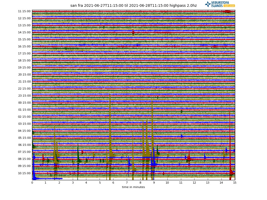
Here is one of the neighbouring stations tremor graph.
The pulsing is on and off. It seems there is a tiny gap after the last pulse period. As if there is a pause.
Lets see how it recovers.
http://hraun.vedur.is/ja/oroi/iss
Credits graph IMO
The new volume estimates have come in. Flow is up to 13m^3/s. With the deflation Carl talked about, this cannot keep up in the long-term. Don’t necessarily believe the eruption will end. However, the rates would drop to the 5-10 m^3/s from the depths. That would make the eruption much less interesting to watch, especially since the lava is getting dispersed over a larger area over time. The rate would be right for a proper shield volcano, however!
Geochemistry figures have been added for since early May. When the flow nearly doubled, the chemistry got somewhat more primitive and similar to the eruption beginning.
What deflation is Carl talking about? Looking at http://brunnur.vedur.is/gps/reykjanes.html I see next to no vertical movement at almost all of the stations.
I believe if you look at the HORIZONTAL displacement of stations in that area , it is possible to see that the eruption site is deflating ( i think there is a plot earlier in this thread)
See here:
https://twitter.com/GeirssonHalldor/status/1408423530493059074
Kudos to Car for noticing this last week !!
I meant Carl …
The lava flood at 15:00 today is worth watching again. either here, or scroll back at the RUV cam for higher resolution. Interesting, no one blocked the view during the main event! I guess everyone was too enthralled by the spectacle to think about bumming the camera
Those standing waves are magnificent.
Thank you. There is some pretty impressive lava fountaining as well.
Starting again…
Facebook groups are reporting the eruption may have stalled around 1700ish.
It stopped after the big burp, around 15:30 local time. That is also why I recorded that video: on the chance it might be the swan song. There was a slight recovery an hour later but over the past hour the seismograph has gone silent again. The visir camera show no activity at the moment. This could be a change in eruption, or it could be the end…
And now there is thick fog.
I don’t suppose we’ll know until the weather clears. However, the tremor chart for Grindavik has dropped to near normal levels, and the drumplot chart has gone quiet. So, at a guess there is a hiatus if not a full stop. But if this eruption was stopping, why would it produce such prodigious quantities of very liquid lava in short bursts?
As we know from the changing chemistry over the last weeks, the magma appears to come from more than one source. I’m going out on a limb and suggest that the current source has finally completed degassing, and nothing will erupt form the vent until a change of magma reaches the ‘u-bend’. That could be a matter of hours, days, or even never.
Meanwhile, will no-one rid me of this turbulent fog?
Check out the MBL Natthagi camera….much reddish glow hiding in the fog!?!? (~2346)
As requested, knights sent to ‘see to’ high priest of IMO ..
Defenitely a pause. Might be the end of the eruption as we saw it till now.
What’s next…, exciting!
Credits IMO.
http://hraun.vedur.is/ja/oroi/iss
do you have a link to a map of all the tremor stations, and a URL link? Thanks …
Gutntog showing a big lava lake reversing, close to the exit of the crater:
WoW
Check out the MBL Natthagi camera….much reddish glow hiding in the fog!?!? (~2346)
At about 0006 on the same camera, I can see a hint of red at the top of the downhill slope. (from south Geldingadir).
(and it disappears, so it’s not lint on my screen 🙂 )
Yes, should be new lava arriving. Horrible visibility
I see those red dots through the fog!
Could that mean that the eruption hasn’t stopped? Or just the lava lake at the top emptying out?
I did the “end of pen pointing directly on the screen” ploy, and opened two tabs. One was set for ~1919, the other for a recent good ‘red blob’ sighting.
The flow is pretty close, it appears. Almost even with the closest smoke to camera, on the left side of the ‘dried’ lava.
Curse You, Thick Fog!
The FAF higpass seismo trace suggests two episodes of gushing for the cone at 18:50 pm and 19:01 pm, but the fog seems to have shut all the cameras down. After that, things are strangely quiet. (other than 3 tiny blips)
Its dead Jim.
When the fog clears, I bet we see a dormant volcano cone, with faint tendrils of smoke wafting up. The FAF highpass seismic trace is significantly clean now. No gas pulses or fluid sloshing at all. ]
]
[
On to the next mantle eruption…
p.s. I could be wrong on the cone shutting down.
The cone is not shutting down, the seismic trace is slowly increasing in amplitude width so something is going to happen eruption wise but at a slower pace than we are used to.
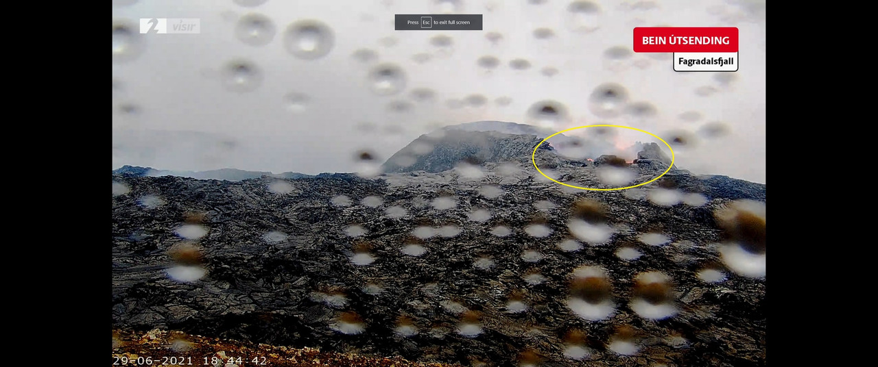
Through intermittent fog, Visir’s close-up cam is definitely showing a strong red glow from the cauldron. Sometimes it’s quite bright.
Ten minutes ago it was showing the red lava tentacles reaching out all around the base. Not rivers but showing the channels of red hot lava beneath the broken black cooled skim on top.
https://www.livefromiceland.is/webcams/keilir-thermal/
The thermal cam is active-perhaps that’s not fog but vog?
On 28/06/2021, from sometime before 17:30 until 19:45, when the fog blanked it out, the RUV Langihryggur camera showed a return to the constant, medium level of activity that was present before the recent overflow episodes. I expect that to be the case when visibility returns.
Some hot lava made it into Nátthagi late last night:
Source for image: https://www.youtube.com/watch?v=XwN-u4Ccygs
Good spot.
Gradually rising tremor again on FAF highpass.
It’s just a lull, and it seems that lull is ending.
Constant tremor is back ..
The eruption is not going to stop
What is this ascii string? it seems incomplete .. An url?
Wish we could see what is going on at the vent. But the Langihryggur camera has been defunct for days now … starting to wonder if it’s ever coming back.
The Langihryggur camera is working fine; it is just obscured by low cloud so far today. The vent was visible for quite a few hours yesterday.
It is fog, the camera is fine, all of the livestreams show working cameras.
I cant speak for mbl or ruv but I would expect them to shut the stream immediately if the cameras broke, not keep it up with a dead screen, it probably costs them a lot to keep it running especially the one that is only helicopter access so it is in their interest to have a working stream 🙂
Visir kept a dead cam up for a couple of weeks! You could still click to pause or play, totally black screen.
RUV camera (Langihryggur) is asking for a PIN to connect!
What on earth is happening?
This one
https://www.ruv.is/sjonvarp/beint/ruv2
Seems to be asking me to confirm my age, then asking for a PIN. Has “Bums of Iceland” gone hardcore?
“BARNALÆSING”
“Efni með 16 ára aldurstakmark og hærra þarf PIN-kóða.”
Hætta við
This channel doesn’t just broadcast the webcam, it also broadcasts other programmes, variety, sports and maybe some less visible stuff for young retinas?
Since I wanted to register, without success, never received the email, all my comments go into moderation.
You are registered. Are you logged in?
I never received the confirmation email or entered a password.
This morning, after reading the messages I tried the “lost password” procedure, same result no email.
That suggests either the email is intercepted before reaching your inbox, or the email address associated with the registration has a typo
Yes, I’ve seen the other programmes, but they were all accessible. Surely they wouldn’t broadcast over-age content at 8 am Iceland time?
I wonder if access is now restricted to Icelandic IP addresses?
For everyone having trouble to access the webcams, I recommend going to the main page of ruv, mbl, or visir. There, find the link that says “Eldgosið í beinni” or “Beint frá eldgosinu”. If you want to open it in youtube, you can right click a stream and select “Copy video URL” (doesn’t work for vísir).
This is the foggy one. I now expect a slow lifting, in a volcanic RUV rendering of the dance of the seven veils
Drone flight over the vent yesterday evening 20.25pm. No real disturbance of the surface is evident.
https://youtu.be/drHx8Ls44Uk
It isnt dead, if it was then the lava lake would have withdrawn into the vent, it is still there and slowly circulating in the video. it is though evident at that time there was not a lot of lava erupting, maybe it was all flowing into a tube deep inside the cone somewhere, maybe into geldingadalir.
In Natthagi, on the right hand side (east) the lava has moved forward by 1-2 meters overnight.
In the Litlihals camera, there is now a car parked on top of the wall. If they make the wall a big wider, it could be a drive-through viewing area. Or a good site for the restaurant at the end of the world?
Three cars now .. and a van is parked halfway up the wall and apparently didn’t make it – perhaps it is serving coffee to any volcanic wanderers.
There’s a digger working (just visible). So perhaps it’s the tea shack, hot dog stand, rest rooms and management centre for the two guys doing the digging.
By ‘management centre’ I of course mean the place housing the HR Department, Health & Safety Supervisor plus H&S Forms Administrator, Lava Manager, Digging Operations Supervisor, Centre CEO plus admin support, IT Webcam Team (currently asleep, off-duty), Marketing and Communications teams, Crowd Control Officer, Fog Manager, Catering Manager and Strong Tea Distribution unit, and finally the Training Department.
Not forgetting the experts: part-time Geologist and Volcanologist interns from the local college (unpaid of course).
This is all economically not well developed (from an entrepreneur’s point of view). Why is bum-showing still free of charge?
That was – of course – a reply to Albert.
For the same reason why we consider the backside views of the cone an also-ran. We want full frontal volcanics
I honestly believe a lot of the visitors just don’t notice the camera. They’re focused on the view, even as the camera is focused on them.
If they can’t notice the camera and associated gear, they shouldn’t be out hiking – they’d be tripping over all kinds of rocks and such…..maybe even twist their ankles on some moss, or centuries-old sheep dung.
Nawwww – they know the camera is there.
Love it- family taking happy snaps in front of cam.Seems to be alot of people about now! Weather reports must be good!
It sounds like giant mosquitos flying around :P.
Is that another camera rig to the left of the undertaking at the Natthagi? (as sometimes seen on the RUV camera?)
Or maybe it’s a sign? “Attention Lava – you *must* be over this height to pass this sign.” Cheaper than building berms and such….
🙂
Nah, I doubt the lava would pay any more attention to such signs than the bum-crowd.
The thing on the left could be a comms repeater station.
Good idea on the repeater station – much needed with all the work being done around there!
‘Bums, bums, everywhere a bum
Blockin’ out the scenery, breakin’ my mind
Do this, don’t do that, can’t you see the bums?’
(with apologies to Five Man Electrical Band)
https://www.youtube.com/watch?v=7-RhgB1INII
They have swapped the tracked excavator for a wheeled one, it can run from lava faster if need be LOL’s
Iceland timestamp 11:55
Me thinks it’s a fork attachment for moving concrete blocks?
There’s a vehicle parked by the right side of the track, it drives off after the digger approached it. Then that blasted fog is back…
Let’s try this one again, for I have no memory of ever posting it before. At each location, stake a marker at the limits of the visual field of the camera lens on either side. Sign the camera: ATTENTION: “This camera feeds to geologist’s station monitoring the volcano. Kindly stand to the side of the boundary markers.” “Thank you”. Hopefully ‘the buns’ will disappear from view.
Scientific monitoring stations, whether they are cameras or meteorological instruments, cannot be tampered with or obstructed.
We all know that people will traverse in front of cameras, especially if the units are in a ‘precarious’ position – the problem is parking oneself in front, or jumping up and down, in front of the unit(s). And it is nice to see a family off to the side enjoying the proceedings, or munching on a picnic basket’s contents.
Besides, imagine if a lost hiker had happened to pass a camera, but the view was obstructed?
OTH they are quite handy to estimate how far below the camera the lava is. I’d guess between 1 to 2 metres, depending on how cautious the visitors are who walk down to it.
Lots of information about current and future planned Mars missions at the recent MEPAG (Mars Exploration Program Analysis Group) meeting – PDFs and video available at https://mepag.jpl.nasa.gov/meetings.cfm?expand=vm11
Perseverance/Ingenuity starts at about 2 hrs 55 mins in. Future Ingenuity flights are planned with flight times of up to 3 minutes and total distance covered per flight to 1km. That’s some upgrade.
Perseverance Project Scientist Ken Farley and Theodore Tzanetos (Lead Ingenuity Operations) also spoke about future plans for Perseverance and Ingenuity.
https://ondigitalshop.com/nasas-mars-helicopter-ingenuity-could-keep-flying-the-martian-skies-for-months/
This is the original source for the linked article but didn’t work for me earlier but does now
https://www.space.com/mars-helicopter-ingenuity-keep-flying-months
Just ran across this drone video of an overflow yesterday, looks pretty cool, and is also 4K. https://youtube.com/watch?v=fTqueFTrYIY
Is my computer low on resources or is there something in the water at Visir or at Fadagralsfjall?
Heavy, man … the walls are moving…
https://imgur.com/a/3lbU9S9
Beat me to it! Proggy webcam man… Go home Visir, you’re drunk…
Oh, same here. Weird.
Is posible sand + water?
jokulsarlon webcam is also sand dirty. I watch daily and is not often.
Water in the electronics, I expect
We’re back in business!
https://imgur.com/a/CMcJmuc
I see the Grindavik drum plot chart is perking up a bit. Perhaps a return to ‘glooping’ and overflowing for the vent soon?
In fact, a glimpse through the rain on the Visir cam shows magma is once again flowing. Not in giant gloops, but I could see it flowing from time to time. The rain makes it difficult to see, however.
Picture:
Yes, back in business
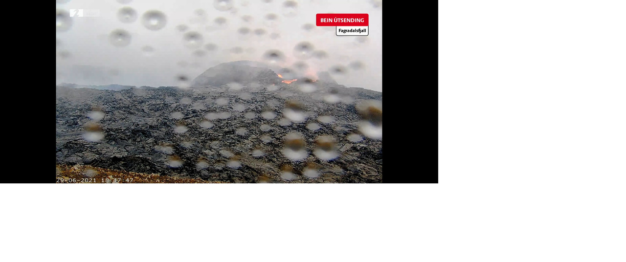
Tremor charts are rising too again Clive, and quite some lava flowing into Meradalir right now.
Still cam 29 06 18.30 😊
Can you post the link for that camera please
It’s visible on this link, if you scroll down.
https://maps.acme.to/gos/
Thank you for the link(s)
That’s ok Doug. I keep losing the direct links, so it’s easier to just keep that one.
I pin my feeds to my browser so I don’t get them lost, I also bookmark them.
Latest batch of whole-rock chemical data from #Fagradalsfjall is now updated in the monitoring plots at http://jardvis.hi.is/eldgos_i_fagradalsfjalli. The initial change toward higher K2O/TiO2 and MgO seems to have peaked in early May. #monitoringcontinues #geldingadalsgos
https://twitter.com/rockhardIES/status/1409832145087041540
wow, looks like someone broke the volcano right now (19:13).
Yes it has some catching-up to do