Six months of episodic earthquakes and ground swelling along the Southwest Rift Zone of Kilauea have finally culminated in a major event. As I write, the volcano rifts. We have a dike. A blade of magma cuts its way across the rift zone generating earthquakes outside of the SWRZ connector, the usual area of seismic activity. The NW rim of Kilauea caldera deflates at dazzling speed. The UWE tiltmeter that most faithfully records the state of Kilauea’s summit magma chamber has plummeted by 35 microradians and is still falling, which is as much as it dropped during the past year’s September eruption. This means a comparable amount of magma has intruded the Southwest Rift Zone in about a day, as was erupted in about five days during the September summit eruption, making it a major event already, regardless of whether it erupts or not.
How we got here
We’ve been following the SWRZ situation in the comment section for months. I also published two articles about it, which are the following:
I will review the situation. On August 14, 2023, following a surge in Kilauea summit inflation and two small summit intrusions, the uppermost SWRZ (Southwest Rift Zone) experienced a substantial episode of seismic activity that gradually propagated downrift and was followed by inflation. This unrest was continuous until the September eruption of Kilauea. After this eruption, the summit entered a recovery period in which the SWRZ was not active. The SWRZ resumed activity with a sudden seismic crisis on October 5. There was spectacular inflation of an enormous area to the southwest of the summit, reaching 1 cm of uplift per day at its center. Activity decayed somewhat after some days, but intermittent episodes of activity lasted until December 15. On December 30 another episode of earthquakes and inflation along the SWRZ took place that lasted just a few days, and from there it was calm until January 27, when a new episode started which has evolved into the current dike intrusion. All of these events generated earthquakes along the same area, which is known as the SWRZ connector, a line of seismic activity that extends downrift from the south rim of the summit caldera. The connector is usually regarded as some sort of horizontal magma conduit that makes up the core of the rift zone. I think it’s more than that though, I believe it represents the upper edge of a complex of deep dike intrusions under the rift zones of Kilauea. This would be the structure referred to in many articles as the deep rift, usually regarded as a vertical dunitic mush body that drives seaward spreading of Kilauea, but its behavior I think is showing to be more fitting of a series of “perpetual” dikes. As these deep dikes expand, what I suspect happens is that the flank gets pushed southward and also the ground above is torn apart making earthquakes along the connector. Rising pressure in the deep rift pushes magma upwards into horizontal sills, producing elliptical areas of ground inflation. That is what I believe the unrest episodes over the past 6 months were.

Map showing SWRZ earthquake activity between August 13 and November 26, 2023. The earthquake locations are from the openly available USGS catalog and highlight the branch of seismic activity known as the SWRZ connector.
The dike
We were having another connector seismic crisis. This one was intense in terms of seismic activity and inflation rates. Things changed yesterday. Towards 4 HST (Hawaiian Standard Time), there was a dramatic increase in seismicity, there were so many earthquakes per minute that they merged into each other. The ground was non-stop shaking in the seismograms of HVO. It appears around this time some magma-filled cracks may have started propagating into the surrounding rock, generating a very intense seismicity. We were following the situation in the comment section yesterday as it escalated. Around 5:30 HST the earthquakes started to hit outside the connector, to the west, and about the same time, the UWE tiltmeter started dropping, revealing that magma was exiting the summit reservoir and Halema’uma’u subsiding as branches of magma spread beyond the SWRZ connector to the southwest. Around 6 HST a cluster of large-amplitude earthquakes occurred in the SWRZ for several minutes coincident with a very fast drop of 1 microradian in the UWE station, at that time it was when I noticed that a dike was forming. IKI and UWE were showing rapid deflation of Halema’uma’u and SDH had also gone crazy with its components showing extremely fast tilting that was probably coming from rapid inflation in the South Caldera area. I went to sleep after another cluster of earthquakes had shown up spreading beyond the connector to the NE, towards Keanakakoi Crater. The intrusion seemed paused, and I thought might be over, but it was not and kept throwing more growth spurts. Now the UWE tiltmeter is down by more than 35 microradians and earthquakes cluster into a nice line, some 6 km long, the trace of a dike intrusion. The distribution of earthquakes is the following:

The orange circles are earthquakes located by HVO today. Blue areas are those active during episodes of connector seismicity. Red lines are possible dike segments that have been intruded.
The map above shows that earthquakes (orange circles) are happening outside the connector (light blue areas) in multiple places. Where they overlap the connector just south of the caldera I think is the starting location of the dike intrusion, given that earthquakes were initially clustered there before exiting to the SW and NE. The distribution may require two separate parallel dikes. It’s not uncommon for this to happen, and the Upper East Rift Zone of Kilauea is known for double dike intrusions where magma makes two parallel but separate dikes, the last time was the 2007 Father’s Day intrusion. The reason could be that these intrusions involve a mix of sill and dike intrusions, horizontal sills turn into vertical dikes so that the whole thing is one intrusion but with multiple interconnected sheets of magma, both vertical and horizontal. In the following map, I compare this event to earlier dike intrusions of the SWRZ, the 1963 dike trajectory is not well recorded so it’s not in it:

Map of the three major, well-recorded, dike intrusions that have taken place since 1970. The seismicity of the SWRZ connector is also shown as blue areas, and the volcanic cones of the Kamakaia Hills as green triangles.
The larger segment would be following a trajectory similar to the 1974 and 1981 dike intrusions. It roughly follows the middle strand of the SWRZ. The smaller segment may be following the southern strand of the SWRZ that last was active around 1800-1810 with an eruption of the Kamakaia Hills.
Will it erupt?
It’s always hard to know the answer to this. The middle strand segment could perhaps erupt in the area of the Puu Koae and Cone Crater cones, but this location is higher than the summit caldera floor right now, so I’m not sure pressure will suffice. The southern strand segment is right now in a non-eruptive area that is too elevated where dikes always fail to erupt, but should it grow downrift it could reach the Kamakaia Hills and erupt there. There is a factor to consider, and it’s the amount of evolved magma that may exist in the area. many eruptions here seem to produce slightly evolved lavas. For example, the last Kamakaia eruption, Kamakaia Waena around 1800-1810, started with basaltic andesite lavas and ended with evolved basalts. This eruption was long-lasting, possibly weeks or months, and emitted some 0.1 km3 of lava. Other earlier Kamakaia Hills eruptions are similar. Prehistoric eruptions of the middle strand, like Puu Koae or Cone Crater have also erupted sluggish lavas and made cones of a strombolianish appearance so while I’m not aware of the composition I suspect they might be slightly evolved basalts. How much evolved magma exists in the area could be a key factor. It’s also important to consider that the major dike intrusions in 1963 and 1981 that rifted the middle strand of the SWRZ did not erupt, and right now Kilauea is in a lower pressure state than it was then. I think that the best chance for an eruption is for the intrusion to follow the southern strand of the SWRZ down to the Kamakaia Hills which are well below the summit caldera floor in elevation and may contain large amounts of evolved magma formed in the past 200 years of dormancy of the volcanic cluster. So as it always happens with volcanoes, they are full of surprises and it’s hard to know what they will do next. It’s also important to note that the area is completely uninhabited, so there’s practically no risk of damage taking place.
Tiltmeters update.
I’m adding a bit about tiltmeters to the article after publishing, to explain a few things. Recently the subject of tiltmeters has shown up during discussions in the comment section. Tiltmeters are instruments used to measure deformation at the Kilauea volcano. You don’t see many explanations of how these instruments work or how their data can be interpreted, so I will explain a few things and show the current event as an example.
Tiltmeters measure changes in the slope of the ground. The unit given is in microradians which is one millionth of a radian, the standard unit for measuring angles. As Albert noted in the comment section of the previous article, a microradian is the equivalent of a change in altitude of 1 mm over 1 km of distance. They are highly dependent on direction, for example, the ground might rise exactly to the north, and this will change the tilt in a N-S direction, but not in an E-W direction which remains unaffected. That’s why HVO reports the tilt as two directions perpendicular to each other, to give a full sense of how the ground is deforming. The direction is given as a number in the top left corner of the graph, and it is an angle in degrees from the north and in a clockwise direction. For example, 90 would be tilt in an east direction. The tilt value itself refers to the angle from the vertical, if the tilt is going up it means the ground is sinking relative to the station in that direction. HVO uses radial tilt. For example, UWE in the NW caldera rim is given in a 327 direction, which is roughly NNW direction, and this direction is radial to Halema’uma’u, it points away from Halema’uma’u, the central magma chamber of Kilauea. When the tilt goes up it means the angle from the vertical in the radial direction of Halema’uma’u is increasing, this happens when the station is rising relative to the ground to the NNW of it because Halema’uma’u is inflating. Up means inflation and down deflation when the tilt is radial to (points away from) the deformation source, here being Halema’uma’u:

UWE data which is tilt radial to Halema’uma’u
Let’s look now at what the other stations are doing. At IKI the blue component is going down and the green not doing much. That means the greatest tilting is happening in that direction. The blue component is 62.5 degrees from the north, about ENE. This seems radial to Halema’uma’u. So down means Halema’uma’u is deflating, the same as UWE.

Then we have SDH, fundamental in monitoring situations just south of the caldera. It gives two components that are going down at similar rates. These components are almost exactly NW, and SW. The maximum tilting must be in between them, or about W. It’s going down. Is W radial to any source? It is roughly radial to the south caldera area, which comprises two nearby deformation centers roughly located near the OUTL GPS and KKO seismometer both to the east of the SDH tiltmeter. This means the south caldera area is deflating because its radial tilt is decreasing; the angle from the vertical decreasing. I should note that originally the blue tilt seems meant as a component radial to Halema’uma’u, and the green component radial to one of the South Caldera sources, the one near OUTL which is related to the SWRZ connector. But because here the deformation is wide and probably spans all summit sources the deformation is coming from the south caldera area that might be a bit central to all.

Lastly, there’s ESC. There are two components. A 0 component (north), is rising. A 90 component (east) is decreasing. At relatively similar but opposite rates. What does this mean? In between them, NE-SW, there must not be any change. The maximum tilting is in the NW-SE direction. It happens that ESC is to the SE of the South Caldera source, so that SE would be the radial tilt to it. This is not given in the graph but, from the two components given, it can known that SE would be down like in the E component but more, being the direction of maximum tilting. ESC like SDH reflects deflation of the south caldera region.

The south caldera area comprises sills that are related to the SWRZ connector and the UERZ (Upper East Rift Zone) connector, twin nearby sources at the start of both rift zones which together are very important areas of magma storage. Very primitive magmas that evolve under the SWRZ and the UERZ (Upper East Rift Zone), probably end up as basalt in the sills of the South Caldera area. This deflation is to supply the dike that right now advances down the SWRZ.
HVO Kilauea page:


Has anyone good current information on the restoration of the hot water piping? Curious as to how this is going? If they are placing pipe over the current lava flow, how are they dealing with the heat?
“Pipeline completed at 1am
Hot water flowing through it from 3am
Storage tanks that supply municipalities filling with water”
Source:
https://twitter.com/shaksper/status/1756963465330069793
Thanks Alberto. Amazing how some news sources said this will take a week, but incredible determination got it done in a day. My hat’s off to the Icelanders.
I’ve recently noticed some earthquakes on Mauna Kea at 5-10 Miles depth, that are close to the linear line from Kilauea to Mauna Kea. Is there still some relation between the volcanoes, that we haven’t noticed scientifically until now? The jump of volcanic activity from Mauna Kea to Kilauea is not accomplished. Is there below Mauna Loa’s NERZ some connection?
Volcanophil:
The “experts” claim that the two volcanoes feed from 2 different sources in the mantle. (most likely based upon chemistry isotope analysis) The best that I can say is that seems to be some support for 2 hot spots leaving a linear trail in the spawned islands. See fig 3 in this webpage: https://steemit.com/geology/@sooflauschig/hawaiian-volcanism-part-2-the-hawaiian-hotspot. So the important question to be answered is this: what exactly is the connection of the hotspot to these 2 lines of volcanoes, as evident from the physical evidence? Sorry, this is not answered your question, which is a good one, but this sheds a little bit more light on the question.
How does the activity jump from the older to the new volcano? Kilauea is around 300,000 years old. It was already active during Mauna Kea’s more active postshield stages. It’s possible, that the shift happened gradually and that there remains some tectonical relation.
Mauna Kea entered postshield stage 250,000-200,000 years ago. Kilauea even already existed during the final shield stage of Mauna Kea. But it’s difficult to imagine how Big Island and the two volcanoes looked like 300,000-200,000 years ago …
It already existed but was less active than today, quite a lot of Kilaueas volume is really only from the late Pleistocene and Holocene, under 50,000 years. Although because it has such a long rift zone the lava pile thickness is not so thick, most of Kilaueas voluminous intrusive complex is within older parts of the island originally erupted by Mauna Loa, and likely so is a sizable percentage of the volume of its south flank too. Kilauea is still coming into its adulthood while Mauna Loa is middle aged and Mauna Kea and Hualalai are elderly.
Some articles do suggest most of Kilauea was already there by 200,000 years ago.
https://par.nsf.gov/servlets/purl/10024818
I personally think Kilauea had strong activity some 300,000-200,000 years ago, then activity returned to Mauna Loa where it resulted in the vigorous activity of the Ninole Hills phase 200,000-100,000 years ago. And since then there has been some emergence of Kilauea activity probably mostly in the past 50,000 years or so.
https://www.higp.hawaii.edu/hggrc/projects/scientific-observation-hole/soh-project-info/
The paper mentions SOH-1, which is a borehole in the lower East Rift zone.
With that said, that would suggest that the East Rift zone was already there during inception.
How was Kilauea’s activity during Mauna Kea’s shield stage? I’d suppose that during that time Mauna Kea did eruptions like we have currently and historically on Kilauea. At the same time the first eruptions of Kilauea began with preshield stage. Isn’t the preshield magma usually rather alkali and explosive than the main shield stage on Hawaii?
How did the line of Mauna Kea cross over Mauna Loa’s NERZ to Kilauea? Are there magmatic roots of Mauna Kea or Kilauea that intersect Mauna Loa’s NERZ?
https://www.volcanocafe.org/kilauea-ii-roots-of-the-hawaiian-islands/
The article written by Hector may answer those questions. It basically explains how the volcanoes are somewhat connected via deep rifts.
The rifts form very early, maybe reaching the maximum length within the first 10% of the volcanos age. The Kea chain of volcanoes also typically have very long rift zones, over 100 km long end to end, and with the eastern one being much longer. The Loa volcanoes are usually not as long, ironically, and taller. Mauna Loa and Mauna Kea reversed that trend, Mauna Kea has no rift zones at all really while Mauna Loa is literally the Long zmountain. But Mauna Kea is very close to its Kea neighbor Kohala which might be the longest rifts of all the Hawaiian volcanoes. And Kilauea once again has very long rifts, while Kama’ehuakanaloa doesnt. The latyer may not even be able to grow into a significant island unless Kilauea grows southwards a lot more and fills in the gap too. Although perhaps a lack of long rifts there might make it vehave differently than Mauna Loa and Kilauea when it gets time to shine.
Basically the rifts form early and they do have consistencies of location. Kilauea also has one of the longest rifts of any Hawaiian volcano even going way back, so could become truely enormous, but we wont get to see Pele at her most powerful 🙁
Yeah, I tried to look for geological interpretations for the future of Hawaii, but all I saw is this –
This is on this site:
https://www.govisithawaii.com/2009/03/17/the-future-bigger-island-of-hawaii/amp/
Okay, image link did not work…
On the topic of rift zones, I found this one paper that suggests that rift zones could grow over time:
https://www.researchgate.net/publication/223092400_Internal_structure_of_Puna_Ridge_Evolution_of_the_submarine_East_Rift_Zone_of_Kilauea_Volcano_Hawai'i
There might be a chance Kilauea could have a longer rift zone in the long term.
Yes a lot of the maps of Hawaii in the future showing Kama’ehuakanaloa as a subaerial volcano seem to assume Kilauea doesnt grow fpr some reason, or that Kohala, Mauna Kea and probably Hualalai are all going to be eroded significantly in the time it will take for Kama’ehuakanaloa to become mature. Mauna Loa is probably getting on over half a million years old if not more and is still in its shield stage, Kilauea is still early in its shield stage and 300,000 years old. Kama’ehuakanaloa is probably comparable to Kilauea in age too, so likely it wont even surface for another 100 millennia unless it gets a major growth spurt.
During shield stage also Mauna Kea likely had its well established rift zones. But postshield activity often hides the former rift zone structure. It forms cinder cones along the former rift zones and around the summit (former caldera ring faults?) like we see on Hualalai’s and Mauna Kea’s summit. The whole prehistorical shield of Mauna Kea is buried below masses of postshield lavas. Therefore it’s difficult to understand the shape of the former shield structure of Mauna Kea.
I’d imagine that during the late shield stage of Mauna Kea, there was relative strong negative correlation of activity to Kilauea. This was likely bigger than the current negative correlation between Mauna Loa and Kilauea, because Kilauea is more close related to Mauna Kea.
I might say, in terms of its future, Kīlauea might be more comparable to Haleakala, as they both have really long rift zones. Hypothetically, Kanaloa (because it would be easier to type than Kama’ehuakanaloa) would eventually buttress Kīlauea and stop its southward growth. Before that, though, Kīlauea might have a massive caldera, perhaps bigger than even the Powers Caldera, that’ll seat its summit as a symptom of its longer rift zone, barely reaching 2 kilometers above sea level due to its spreading southward.
The Hilo ridge is a part of Kohala volcano, while Mauna Loa sat to the south, and Hualalai (at that time probably similar in size to Mauna Loa, maybe not as tall) sat to the west. Mauna Kea probably never had the long rifts that are typical. The post-shield eruptions still follow the structural weakness of the volcano and concentrate on the rift zones, which is the case at Hualalai and at Haleakala, so the fact Mauna Kea is radially symmetrical likely means it always was. When it was in shield stage it might have been more of a Galapagos style shield with a wide caldera, maybe a lot like Sierra Negra, which has shallow slopes compared to the other Galapagos volcanoes. Kohala in its shield stage had a summit under present day Waimea so was close enough too that possibly the wider magmatic structures at the center of the two could interact, and maybe Mauna Kea did occasionally intrude the Hilo ridge, but that is only speculation.
I doubt there was a lot of interaction between those two and Kilauea though. The Loa-Kea trends are geochemical trends but dont necessarily mean much regarding magma pathways. And from what Hector has posted before the simple model doesnt really give the whole picture or give any data about shorter term interactions. Mauna Loa and Kilauea are on different trends but appear to interact significantly, but Kama’ehuakanaloa appears not to interact with either of them much or at all, and it is a Loa volcano but both it and Kilauea are much closer in age than either is to Mauna Loa. And Hualalai is older than Mauna Kea but much more active while similar age Kohala is extinct…
Magnitude 4+ quake south of the ERZ of Kilauea, near where the 2018 quake epicenter was. Its not on the seismometers yet so might not be real but if it is then that could be significant. The SWRZ just did a lot of rearanging so makes sens if other places start moving around a bit in response.
Im sure this has been linked by now before but this is the speed of the lava as it flowed over flat ground near Svartsengi.
https://www.facebook.com/share/p/dYeUiWJjX4nPCyq2/?mibextid=I6gGtw
Its one thing that a number of us have been saying eruptions at this location would be highly intense and fast, but still actually seeing in real life on video still doesnt feel real. The last eruption had a peak output of 600m3/s, which is as high as the start of Holuhraun. If future eruptions shrink to shorter fissures with higher rate then Grindavik might be saved from direct destruction yet but we get unpredictable long and very fast lava flows going all over the place
The output rate is 50 times higher than Fagradal’s 12 m³/s in many cases. The high speed of the voluminous lava flows make the path of future lava flows unpredictable. They remind to Mauna Loa’s 1950 speed with quick ocean entry. It’s possible that Grindavik gets such a quick ocean entry. The whole town sits on old lava layers, and the port can easily be buried with lava.
The short liftetime of the episodes help to localize the risk of each and exclude many areas. But the location is difficult to predict. On the longterm view, it’s more likely that lava flows will cover a big area from the sea to Fagradalsfjall’s shield.
1950 ML flowed down a hellacious slope that exacerbated things. Grindavik is practically flat by comparison.
(I’ve driven HI-11, it’s a jaw-dropper. You can’t even see the rift zone from the highway, which is unnerving in some respects if you own property in South Kona and the rift unzips again.)
It is an exaggerated comparison. I was amazed by the speed of the recent Svartsengi lava flow that nearly caught some bulldozers by surprise. Added to this the warning time for any eruption has decreased since December. An eruption starts suddenly and may choose randomly either a lucky or bad direction for highs speed lava flows.
Sooner or later we should expect an ocean entry scenario. That would also be a nightmare for Grindavik. It can happen very quickly.
If this last eruption opened just above or next to Hagafell it would have flowed into the ocean then, same place is where the ocean entry last time flowed down from.
Whilst it may not go much faster than you could run on that terrain, its of the same order and doesn’t get tired. Next time we approach an eruption a significant area would need to be evacuated well before the event happens. This may be politically tricky. If its a key area like the power plant or airport its even more problematic. Personally I suspect the power plant has extracted enough heat at enough depth that it sits on a solid raft that is not easily fractured.
I think after December the decision was already made that these eruptions were dangerous and not approachable like the 2021 eruption was. Even in July at Litli Hrutur the eruption was faster than in 2021 and had some moments where the authorities intervened.
I guess the main risk is for an eruption to flow near or into Grindavik as fast as this one did. The town is not occupied but still there are people physically there. Its likely the damage caused by the cracks in November and the loss of one of the workers filling them in has significantly reduced the risk of an eruption taking any lives though. Its more of an economical problem at this point not a Goma #2, which is what I had long thought this area to be. Still if Grindavik is there in 2030 it is a coin toss at this point.
A difficulty is the decreasing warning time. I’ve read (correct or not?) that the 12/2023 eruption had a warning time of 90 minutes, while 2/2024 had only 30 minutes. That’s less than Hekla’s typical warning time. So hikers and any other kind of people should avoid the whole area.
Its not quite so bad. There was in fact a lot of evidence that an eruption was likely in coming days/weeks due to gps and satellite showing the locality was rising. What is now unreliable is any short prediction (hours, a day). So whilst inflation is modest its probably pretty safe, if there is significant inflation then the hazard level is significant.
Thanks for that link, Chad. It was fascinating reading how the snow and lava interacted. Watching the webcams, it had puzzled me why the snow seemed so pristine and untouched as it was engulfed by the lava. Now I’ve learned why!
Had some thoughts about the emerging GPS data from around Svartsengi. Again I’m just speculating, but …
1. The uplift epicentre does seem to be very close to SENG station. It’s not just that this station captures some of the most dramatic uplift, it also never seems to go down much after the eruptions, even though we know that the magma is being transferred from this area across. Therefore…
2. Is the almost uninterrupted uplift without much post-eruptive event subsidence a sign that there is a larger magma storage area being created, or that some crystallised magma is occupying space after each ’emptying of the tank’, or both? (maybe there are other theories that could also explain this)
Sometimes I wish I was a geophysicist, to have an idea of the elasticity of the underlying rocks would be a dream come true. Since the November dyke was created, we’ve seen a total of nearly 600mm of uplift, and stripping out that huge uplift + subsidence created by the dyke creation, we’re now at 250mm above the pre-November baseline. There must be an explanation 🤨
“Is the almost uninterrupted uplift without much post-eruptive event subsidence”.
I think it’s mostly from dikes. Dikes do uplift the area around them, it’s only a small area immediately above that subsides. SENG is probably within the area uplifted by the dike intrusions that are concurrent with eruptions. Growth of the deeper parts of the dikes, or of a dike that was already there under Sundhnukur before the current cvcle, during intereruptive periods probably uplifts SENG too, adding to the signal from the Svartsengi sill.
Yes that’s a good point. I think Professor Þórðarson also mentioned before that the SENG GPS metre could be on the wall of a dyke, so that could be the most plausible theory. The idea that it’s above the feeder is also interesting, I wonder whether we’ll find out more about this as the events continue.
I think the centre of the sill is a bit south of Svartsengi. However, I think Svartsengi is close to the feeder to the dyke, which could explain why it didn’t subside in January. It did subside in November and during the last eruption.
The first eruption in December occurred in the Svartsengi area; the second eruption instead occurred south of the fault line near Grindavik; the third eruption instead returned to the Svartsengi area.
I believe the fourth eruption will probably occur in the Grindavik area.
It seems to me that the position of these eruptions follows a pattern of balancing and counterbalancing, first on one side and then on the other.
I might be wrong.
However, I notice an interesting seismic swarm slightly east of the fault line. New dam in formation?
Equally interesting are the earthquakes between Fagradallsjall and Lake Kleifarvatn.
If you mean a swarm today, just to the east is Fagradalsfjall.
The new hazard map has the worst “red” risk between the place ot the recent eruption and Grindavik. An eruption there can possibly send lava downhill to Grindavik:
https://myndir.ruv.is/eyJidWNrZXQiOiAicnV2LXByb2QtcnV2aXMtcHVibGljIiwgImtleSI6ICJtZWRpYS9wdWJsaWMvb3JpZ2luYWxfaW1hZ2VzL0hhZXR0dW1hdHNrb3J0X3FvTFZwWmkucG5nIiwgImVkaXRzIjogeyJyZXNpemUiOiB7IndpZHRoIjogIjEyMDAiLCAiZml0IjogImluc2lkZSIsICJoZWlnaHQiOiAiOTAwIn19fQ==
I think it’s far more likely to be essentially random. “NSN” and “SNS” together comprise a full quarter of all the possibilities given coin-toss odds of it going north or south each time. It’s therefore not especially unlikely that the first three might have alternated like this. We simply don’t have enough evidence yet to reject the null hypothesis of “no pattern”.
Now, if it keeps alternating through three more eruptions, then it would be time to sit up and take notice as the p < 0.05 threshold would have been crossed.
I have followed the GPS data for uplift and tectonic spread esp. close since the eruption ended @ https://strokkur.raunvis.hi.is/gps/8h and I *think* we are seeing a faster rate of ground uplift than before around Svartsengi (4h data since eruption ended). If this turns out to be the case it is worrying.
I see no other explaination than to see what happens in Reykjanes as a historical rifting episode with continuously infill of magma due to the land rifting/spreading. The mannor has been fairly controlled thus far, but if the speed of rifting increases it can affect both the longivety of eruptions and the speed and volume of eruptions. The rifting clearly goes deep, and therefore clearly can implicate this or that other areas in the close proximity also can “give” from this. Iceland is speading, and we are in a period where the main “concrete floor” above the magma highway is cracking.
I think it is important to note that during the last episode of activity along the Sundhnúkur dike some 2.360 years ago it is found that the lava formed the natural port of Grindavik. Now IMO states that “the ground has been bulged by 0.5-1 cm per day over the past several days, and essentially following the same pattern of previous eruptions on Reykjanes Peninsula.” That (on avg) means only 16 days from the end of last eruption untill uplift is apx where it stood before this last eruption. We also know that in the last historical active period from apx. 1210-1240 the lava flows from Svartsengi alone covered 50 km2.
When in the past there have been prolonged fissure eruptions I think this must have been the mechanism behind it; a prolonged period of fairly fast tectonic rifting that enabled magma to reach the surface continuously for a prolonged period of time. Giving no or little time to “heel” or solidify. As there is no known large central chamber this would probably not make sense and at least not produce large eruptions. But large for Reykjanes, and that is what worries me. *If” a reactivation now only takes 15-20 days and output is fast flowing lava representing10 mill m3 every time, that would be a very bad scenario if that is the case. I hope I am wrong and that trend of uplift around Svarsengi since the eruption is just too early to establish correctly. Could the speed and timeline for the tectonic rifting be the key to understanding this?
Since we do not know if the tectonic rifting will increase, decrease, move or extend in area over time, this seems a very difficult scenario to foresee the development of.
We all hope for the best outcome, but should prepare for the uncertainties that history gives clues to.
ADAV, trying to fit the big picture of the tectonic rifting needs to also be factored in. The Eldey quake swarms are no accident, they are connected (imho). As I glance at the quake map today, it seems like the whole west Reykjanes peninsula is shifting around in response to these small fissure eruptions.
It’s possible that during the last 2,360 years also tectonical movements changed the cost and landscape there. This may also be a reason for Fagradalsfjall’s fragmented landscape. I’d assume that the Middle Age Fires also caused a lot of tectonical movement along the whole Peninsula that might be lost in historical records.
I think it was Albert, who wrote an article, with images showing how Fagradalsfjall and the rest of the peninsula has shifted. He lined up features to demonstrate.
Copying my question from the bottom of the previous page.
Looking the Langihryggrur webcam on live from Iceland it looks like there are a couple of spots where the lava edge is still glowing. They are still glimmering a bit red this evening. I guess this would be from the crust at the edges breaking and revealing the glow of the still hot lava.
But to so this wouldn’t it need to have fresh magma pushing out the cold crust? Therefore question for everyone.
Is it possible that a small amount of lava is still erupting slowly and is flowing in hidden lava tubes which are then extruding slowly at the edge of the flow? What’s the likelihood of this? If lava is still erupting under the crust of the existing lava flow, does that have any meaning?
I saw that last night two. Wish someone with a night drone and an IR camera could take it up over these 2 spots and find out what is going on. I know that the IMO does have IR drones now.
That would be fab. But I guess access in the dark with the road cut off and not a lot of other options close by is a bit of a blocker
This is a question to the administrators of Volcano Cafe. Do you have any plans in the works to create a webpage for mobile telephones? My Apple Iphone 14 does NOT display the posts correctly, and things run off on the right hand side, after a certain numbers of replies occur for a post at the root level. I cannot even read the information posted.
It would be very nice, if a mobile version of Volcano Cafe could be created.
It helps if you can read the posts with the phone sideways. I have a similar problem on my Android phone.
Have you tried turning your phone sideways?
ah.. great tip! this seems to work.
The current advice is as given by CN and YBNormal: it is not a fix but it works. We are hoping to have something better but VC runs entirely on volunteer activity so there is limited (wo)manpower and things take time!
Thanks Albert – I can verify the sideways hack works but usually end up waiting until I’m at the desktop again.
Thanks again for all you and the team do to keep us educated and informed.
I just set the tab to desktop
As is the recommendation since the problems started.
https://www.volcanocafe.org/the-look-and-feel-of-vc/
I remember this happened at least once before, when the wordpress theme was updated. That time it was fixed by someone. Maybe it was Henrik?
Anyway, the desktop workaround does the trick. If the text then becomes too small, turning the phone sideways makes it better.
Basically a pseudo-version of Reddit but volcanoes?
But, yeah, I turned my phone around to read the full details.
If on your phone internet you click read in desktop mode on the settings it makes it better.
A new volcano to learn: Gareloi. One of many unkown volcanoes for me. Now upgraded to yellow.
Gareloi is an Aleutian volcanoes. It sits nearly in the middle between Kamtchatka and Shishaldin, close to Tanaga island.
Alaska Volcano Observatory observed increased seismicity, “observations suggest the presence of shallow magma and potential interaction with a hydrothermal system. The current increase in seismicity likely reflects a change to the magmatic-hydrothermal system, but it is not clear that the likelihood of a volcanic eruption has increased.”
The last significant eruption happened 1929. There was a 4km long fissure with predominantly explosive activity and minor blocky lava flows. Likely some kind of strombolian fissure eruption. Partially phreatic and partially explosive by Andesitic magma composition.
The last (minor) eruption was 2018 with a 5km long ash deposit.
2008 USGS published this Preliminary Volcano-Hazard Assessment: https://pubs.usgs.gov/sir/2008/5159/
16 eruptions happened historically until 2008. 11 produced significant amounts of ash. The highest ash clouds were 12km high. On the base of past eruptions they assume that Gareloi has an episode of volcanism every 20–50 years. Tsunami risk is low, because eruptions usually are relatively small.
Hey, may I ask, are you GeologyHub?
No, but interested in all kind of volcanoes and looking for some which are active when Iceland and Hawaii do pauses.
My apologies, it is just that, about five hours after your comment, Geologyhub released a video on the same volcano:
https://youtu.be/h8iJXmDycfs?si=Tbx4QhLwMJoJiY0G
Geohub has more knowledge/information than me and different voice 😉
During “boring times” yellow advisories open an opportunity to get to know new volcanoes, even if they in many cases in the end do nothing.
https://icelandmonitor.mbl.is/news/news/2024/02/13/had_an_idea_of_a_suspended_pipeline_over_tha_lava_f/
They were thinking about building a free-hanging pipeline (I think) to avoid getting the pipeline from getting buried by lava.
Yeah but whatever is suspending it will have to also be lava (and quake) proof. No good if it’s held up by some girders and chains and they melt.
I thought “what about balloons? The pipe itself is a source of heat that could be used to keep them lighter than air”, but the kind of weather and winds they get there would play merry hob with balloons …
Unfortunately there probably isn’t a good solution. Route around — it’s a plate boundary, the plant is on one plate and (some of) its customers are on another. Plus length = expense. Bury deep enough not to be affected by lava over top … and it’s more susceptible to breakage from earthquakes, in one of the most quake-prone regions in the world. In the end, I suppose a titanium pipe with titanium supports spiked down into bedrock and some expansion joints would work, and being hit by lava would then just add more valuable energy to the pipe’s contents, but titanium is expensive and I’m not sure you can make expansion joints without involving less heat-tolerant materials.
Titanium is very reactive at the temperature of lava, it would probably react with the lava itself and make some sort of weird mixed oxide stuff and if the heat got through to the water it would go up like a bonfire. Its unreactivity at ambient conditions is really the unreactivity of TiO2 that forms a thin layer on the surface,
Titanium doesn’t react with oxygen or jet fuel in jet engines, which reach comparable temperatures. It’s different if there’s water in contact with it?
There is a heat camera (stills) on Husafell, with a normal view side by side.
https://brunnur.vedur.is/myndir/webcam/2024/02/13/webcam_husafell.html
You can also access it from here – https://brunnur.vedur.is/myndir/listi/
Just scroll down, and it is not hard to find.
I fear that the whole valley from Husafell in SE to Thorbjörn in NW is going to become the Highway for lava.
The recent eruption was an excemption that lava was able to run west through Sylingarfell’s passage. But the general direction is likely going to be from Hagafell/Sundhnukur towards Grindavik port (road “Bakkalág” marks possible ocean entry area)
It would be very difficult to contain a lava flow originating close to Grindavik. But one further up the valley may be easier. The area is quite flat, so lava does not flow as far and perhaps can be steered. The fact that we can talk about eruption containment shows how far Iceland has come! Grindavik is badly damaged in places but I don’t think the locals are ready to give up on it. The worst thing is the uncertainty, but these eruptions will not last forever.
Iceland is very professional in dealing with this nature disaster, it has sufficient economical ressources to invest in “volcano policy” and also has wisely decided to spend money for this. So they are well equipped for the next lava challenge.
If we look on the lava layers of the last Svartsengi eruptions, I’d assume that it’s easier to predict the lava coverage of the whole Fires Series than to predict the single episode. But it needs some courage to predict the evil outcome that no one wants.
https://thearmchairvolcanologist.com/2023/11/10/intense-earthquake-swarm-near-grindavik-aviation-code-for-the-reykjanes-svartsengi-volcanic-system-orange/
Found this on the Armchair Volcanologist website, the data a little outdated as it was written at the same time as the November 2023 dike, but the information is quite interesting. Check the geodensity of the earthquakes:
Two things: check the thermal map from the satellite which shows some thermal anomalies, matching the image posted, but also showing a warm spot to the west of Grindavik. Secondly the new paper out on the dike formation in Nov has an interesting picture in Fig 1 of the previous Eldvorp lava flows which hints that we’re due for a long period of fissure eruptions in the Svartsengi area. https://en.vedur.is/about-imo/news/new-understanding-of-ultra-rapid-formation-of-magma-filled-cracks-in-the-earth
https://www.sciencealert.com/insane-nasa-satellite-image-reveals-heat-leaking-from-icelands-new-fissures
Insar of Kilauea from February 9th, showing the deformation from the 28/01/2024 to 9/02/2024, encompassing the recent intrusion. We have to wait another 10 days to get one completely after the intrusion but it is clear what happened anyway, the summut drained but so did all of the upper SWRZ connector, it is clear as day the curve of the rift.
http://www.mounts-project.com/static/data_mounts/kilauea10/2024/kilauea10_20240128T161642_20240209T161642_VV_ifg.png
The tilt is also dead flat since the end of deflation at both summit tiltmeters, when after all the recent summit eruptions it began rapid inflation immediately. To me this looks like magma is now flowing into the SWRZ at the same rate as the supply, which is what happened with Pu’u O’o… To be sure it is a long term thing we will need a few more weeks but if this is indeed the case then an eruption is likely to occur this year and the summit might not necessarily appear to be ready. The Kamakaia eruptions look to have erupted a bit differently than most familiar Kilauea eruptions so a typical series of precursors may be an optimistic expectation.
Kilauea has a lot of subsurface space to fill with intrusions. It isn’t as quickly forced to erupt as Svartsengi. It has rather something in common with Krafla, that 1975-1983 did many intrusions that didn’t erupt, because the volcano allowed space for subterranean intrusions.
Its probably somewhere inbetween, Kilauea has a large volume storage but it also has a high ratio of eruption, at least half the lava that goes through the Hawaiian volcanoes erupts, although that is long term and short term is highly variable. Krafla was probably only 1/3-1/4 of the magma erupting, maybe less even, but the last few eruptions were likely much more eruptive relatively.
For Svartsengi I think that number remains to be seen yet, the November intrusion didnt erupt at all, which will offset things, but it seems both the December and February eruptions were mostly erupted with very little lateral magma flow.
Been looking back at the earthquakes that have happened during the recent set of intrusions from 2021 onwards. It is pretty clear that the so called triger quakes are not entirely tectonic. During the 2021 eruption all of the Reykjanes fault from Kleifarvatn to just east of Svartsengi moven, and it does look like a linear group of quakes in that swarm followed the same trace under Sundhnjukurgigar as the active rift now. The intrusion under Fagradalsfjall at the end of 2021 also fired up the area and so did the intrusion and second eruption in August 2022. The intrusion and eruption in July 2023 didnt though, which is interesting.
The quakes that would happen under Kleifarvatn are interesting, as are those east of Trolladyngja in the 2023 eruption. Those are both part of Krysuvik but are not on the same fissure swarm, so it may be a bit of a coin toss between the two. East Trolladyngja eruptions are massive, similar style to the one last week but much more area covered and longer fissures, and in the last cycle there (which was also the last one Sundhnjukurgigar erupted in…) did end up reaching the ocean on both sides of Reykjanes. An effusive eruption at Kleifarvatn would not really flow over anything, but an effusive eryption under that lake seems unlikely, which would be a real danger being so close to Reykjavik.
The other line of quakes that has been showing up under Fagradalsfjall but not on the trend of the 2021-23 eruptions is also very interesting. The eruptions happening so far on that system have all originated from dikes that started north of fagradalsfjall, so might not necessarily be related to this other trend. There are some Holocene vents that line up with this new quake trend too.
White lines are the vents that have opened from Sundhnjukagigar so far, to compare their location to quakes that occurred during the Fagradalsfjall intrusions. Lava flows of each eruption are also shown.
Fagradalsfjall eruption 2021
https://i.imgur.com/axrdCkp.jpeg
Fagradalsfjall intrusion Dec 2021-Jan 2022
https://i.imgur.com/POkh1Uo.jpeg
Fagradalsfjall eruption 2022
https://i.imgur.com/m7du7wQ.jpeg
Fagradlasfjall eruption 2023
https://i.imgur.com/1Y9j1GN.jpeg
Basically all of these intrusions except in 2023 saw significant activity in the area that would later rift open and erupt.
Correct quake map for the 2023 eruption:
https://i.imgur.com/Udj5YIJ.jpeg
🙂
Fagradalsfjall has until now shown a northward trend of eruptions. The first was in Geldingadalir, the next on the north side of Meradalir, the third jumped over mountain towards the north. The fourth could happen around Keilir, if this trend continues. Then lava flows would run north towards the northern coast road.
Is the Fagradalsfjall the “Vatnajökull” of the Reykjanes Peninsula? We don’t know about the seismic and magmatic activity there during the Middle Age or the Ancient cycle. It’s possible that it is the heart of the volcanoes there and distributes magma to Krysuvik and Reykjanes, even in cases that Fagradalsfjall doesn’t erupt.
I think each ‘segment’ of the fissure swarm has the ability to build up stress, have a quake swarm, and then begin to form a temporary magma chamber which in general appears to reside in the American plate and dike eastward when primed for eruption. I don’t think there’s any source or mini-hotspot, or that it all comes from near Fagra, I think each segment generates it’s own magma storage when the right conditions are met.
The magma is fairly similarly generated, but not necessarily erupted the same way, so any differences between lavas erupted would be engineered by storage time in the crust as well as the layers of crust it has to erupt through.
The eruptions have trended north but that could be in part because the fissures are short, so at this point each dike is opening a new bit of the rift. At Svartsengi where the fissures are much longer there is no such preference in either direction.
I guess it would be useful to look at the volume of the last eruptions at Krysuvik and Svartsengi, on either side of Fagradalsfjall. In both cases that seems to be getting on 0.5 km3, maybe less but still. The 2021 eruption therefor only erupted a bit more than a quarter and still most likely less than half of what a typical fires series here would. Its also unclear how much magma stays underground in the dikes, I thought it might be 90% but that seems far too much, but the number is likely more than half. However the slow dikes might struggle to go a long way outside the eventual eruption zone so have much more erupted. If the total magma available is in the range of 1-2 km3 and 40% of that erupts at Fagradalsfjall then we are only about 1/6 the way there yet. So either we get another decade of small eruptions once or twice a year or another long abd voluminous eruption again. And that is just the recent eruptions which start south of Keilir, the new quake trend under Fagradalsfjall itself and parallel to the Svartsengi rift would be its own thing entirely and maybe give a round 2.
We have not seen anything yet.
Yeah Svartsengi is a bit different to Fagra, that one seemed like a gradual creep northward as the dike expanded out, rather than making and filling the dike first and relying on overpressure to erupt.
I don’t think there’s all that much room to store the magma in the crust as the crust is quite thin, the MOHO at around 8-10km. So it is likely to mostly be pushed out or solidify within the peninsula fairly quick. This is where Hengill and Krafla will be different again as they can probably store it for longer.
I was just looking at the Halema uma u crater webcam (USGS). There is a glowing spot of lava. I assume this is normal to see in the crater?
Oh.
I switch back 1 minute later and its gone. Scrolling back there appears to be a reflection on the lens which slowly moves across the crater with the sun, and it really convincingly looks like a small lava lake. Damn you, sun! 🙂
More little clusters of quakes around Eldey in the past 24 hours, so I finally made the effort to read about it. Seems it’s unlikely to add any drama, that’s just it’s normal behaviour.
But I didn’t know about the fate of the Great Auk on Eldey. Miserable. Utterly depressing. I’m not throwing shade on Iceland, we’re all the same. If the Vogon Constructor Fleet ever did arrive, we’d be hypocrites to complain.
The Great Auk was the Penguin of the Arctics, the first bird species to ever be labeled “Penguin”. Can biologists breed a new one from Auks as they did with the Aurochs?
Volcanophil, re. the auks, yes, even if the “resurrected” critter is not genetically identical. If it could perform the same functions in that niche environment, it might be good in a “rewilding” scheme. (Rats are a terrible problem with ground-nesters.) I think the “neo-aurochs” live in an European protected forest, to conserve that distinct eco-environment.
Iceland might see this as competition for its fishing industry!
Well basically all of that rifting and intrusion Kilauea just did, that just set things back to about the same place it was at just before the September eruption. So give it a few months or so and round 2 should be on the way. It also likely means the September eruption was about at the limit of elevation the magma can reach before a flank eruption is preferable, which makes sense with how active the upper SWRZ connector was just before and how quickly that rift started quaking again just after.
MANE and HLNA stations show, where the intrusion went to:
In the HVERI video they said that the intrusion was more voluminous than the last eruption (9/2023).
It makes sense that it was, given the summit contracted by about twice as much and there was also magma drained from the upper SWRZ. 1 microradian on the UWEV tiltmeter seems to correlate with about 1 million m3 of magma being moved, either added or drained out. So by that logic about 65 million m3 of magma left the summit, which is about a rate of about 750 m3/s for the about a day the intrusion lasted. So like at Svartsengi the intrusions are very fast, if it did erupt on day 1 it would have been a very intense eruption like 1974.
Looking at the GPS maybe I was wrong in thinking magma is still draining into the SWRZ, it looks like the caldera is extending again as expected. But it is still doing so very fast even more so than after the last eruption. Maybe there is some south flank movement pulling CRIM south but I dont know if the caldera area itself is affected by that. If that isnt the case then that is some extreme inflation, CRIM and UWEV have moved apart by nearly 10 cm since the end of the intrusion.
Here is the HVERI video: https://www.youtube.com/watch?v=Cljje_AeaOM
At 1:11-1:12 they show a column chart that reveals both volume and eruption/intrusion rate for the six events since 2020.
The biggest eruption (volume) was 2021 with more than 0.1 cubic kilometers, but with the smallest rate of 2.9m³/s
The three eruptions 2023 had a nearly constant volume of around 20 million cubic meters, but they had an increasing trend of eruption rate:
1/5/2023 had 3.1m³/s
6/7/2023 had 15.34m³/s
9/10/2023 had 35.88m³/s
Each eruption had a larger rate than the previous one. This trend continues with the recent SWRZ intrusion with a rate of 115.74m³/s and a volume of more than 25 million m³.
The eruption in June 2023 had five times the rate of the previous one. The third in September doubled the rate. The intrusion increased to three times of the previous event (eruption).
My previous posting was wrong in mentioning volume. The rapidly increasing rate was the main important trend. If this trend of strong rates continues, the next intrusion/eruption will develop very fast and with a sudden outcome. The volume doesn’t need to be very huge, but the rate matters.
It went down to the same length it had when the September eruption ended. As far as Kilauea is concerned, this was an eruption in the sense that a lot of magma was pushed out. The only difference is that it was pushed out horizontally rather than out. It ended at the same point where the pressure in the magma chamber was no longer sufficient to keep the outflow open.
Well, no, it isnt an eruption as no magma ended up at the surface. It was an intrusion.
But based on how relatively little this actually relieved pressure, and that the SWRZ connector is still quaking quite a lot, it seems the event is just postponed not cancelled. In fact based on the rate of extension of the caldera now, which does appear to be inflation not southward slipping of CRIM, it might be a lot less than 5 months before next go. It took that long to break the connector but just like we see at Svartsengi o ce a break exists it takes a lot less pressure to reuse it. At this rate Kilauea might do another intrusion in a month or two. It might not erupt that time too but if what happened in the 1960s is any comparison then the Kau desert might look very different in 2035.
Sure, it did not erupt. But from the point of view of the Kilauea magma reservoir, it is irrelevant whether the magma ends up on the surface or in a dike. It has gotten rid of it and now it is someone else’s problem. The SWRZ has managed to contain it – this time.
More that I mean an eruption has a definition that this event didnt fit, so it isnt correct. That it did drain magma away from the central magma chamber is true. There is an important difference though, in that an intrusion takes up space so increases the chance of an eruption the next time. An eruption will spread out and needs to build a large structure to affect magma pathways to the same degree.
The way I see it is the only way we dont get a SWRZ eruption this year is if the ERZ becomes available. The next eruption could still be a summit eruption abd it is likely the summit will still erupt frequently in the near future too but eruptions there will not relieve pressure now the crater floor is high enough.
The volume of the intrusion wasn’t very much, but the force and rate was impressive compared to the 2020-2023 summit eruptions. This looks as if a possible SWRZ eruption will begin violently with a high rate of lava output, but because of relatively small volume it will decrease quickly.
1919-1920 the eruption lasted for 238 days and had a volume of 0.04 km³. This would be an average rate of 2m³/s
1974 eruption was like this. Mauna Iki was just lava from Halemaumau flowing down a crack, same as Pu’u O’o rupturing in 1986, 1992 and 2007 to make lava shields east of the cone but directly fed by it (as opposed to 2018 which was much larger and deeper)
Most eruptions at Kilauea begin at high intensity, just like at Mauna Loa, just that unlike Mauna Loa which has all of its storage in one large summit chamber Kilauea is distributed over many smaller areas, and it is also much flatter so gravity cant act as much. But many historical eruptiobs have been extremely intense, the 1952, 1967 and the 1970s summit eruptions probably opened with eruption rates of over 1000 m3/s. Same with the 1974 SWRZ eruption. Most of the ERZ eruptions also started off very fast. 1960 began at a similar size to the last eruption at Svartsengi but it never let up and was doing 500 meter fountains within days. The Mauna Ulu and other middle ERZ fissure eruptions and fountain phases at one point sent lava flowing 13 km into the ocean in a few hours. Part of the fissure that eventually formed Pu’u O’o erupted a lava flow that advanced 5 km through the jungle in an hour.
Basically, if we get an eruption like that we are potentially even looking at an ocean entry. If the dikes erupt in that stage things are going to be fast.
I’m confused. The Blue Lagoon has re-opened, and is claiming on this evacuation map that road 43 is open … right through where the lava flowed less than a week ago. Is that right? Have they already built it over the lava somehow? Isn’t it still hot?
https://assets.ctfassets.net/w65k7w0nsb8q/2G9i8C8ZTtqYb3Eg6ksIrp/1ba01822d90fbb88fe116fa0eca90e1b/Evacuation_Map_140224.pdf
Also … the advertised route into and out of the Blue Lagoon is now via Grindavik. Are they really happy sending inexperienced tourists driving unfamiliar vehicles (many without even 4×4) directly through an area where they might be cut off by lava without notice? It’s entirely possible surely that a fissure could open in Grindavik and close that route off, leaving no escape except across the land to the west of the Blue Lagoon.
What am I missing?
Apparently a road actually was made over the new lava already, not through it though.
Impressive!
The new route to the Blue Lagoon is via Grindavik from the south, the fact that a gravel road over the lava flow on the Grindavik Road north of the Blue Lagoon is irrelevant as using that road is not the approved path for entry into the resort.
Not irrelevant in the case of an evacuation – that’s what I was talking about in my first para. I thought that direction was completely blocked off and hence the only evacuation route would be south via Grindavik – decidedly dicey depending on where the next eruption comes up. Turns out they have built a road over the lava to the north which means they do have two different directions in which to evacuate … but I doubt that will fill tourists with very much confidence. Going there right now is a significant risk, that’s for sure.
The Blue Lagoon Road to the north is totally blocked so you cannot flee north.
If there is a way though the power plant as an escape route on to the Grindavik Road, then I haven’t seen it advertised.
It is shown as a route on the Blue Lagoon’s own evacuation map:
https://assets.ctfassets.net/w65k7w0nsb8q/2G9i8C8ZTtqYb3Eg6ksIrp/1ba01822d90fbb88fe116fa0eca90e1b/Evacuation_Map_140224.pdf
In my experience and from reading through several iceland travel groups, a large portion of tourists isn’t at all perturbed by the thought of swimming right next to a very active volcano with potenially no evacuation route left. Most are under the impression, that it’s perfectly safe or the authorities wouldn’t reopen the Lagoon.
I’m not sure how to feel about that. Darwinism?
I get the impression that a lot of tpurists would actually like to see it erupt up close, seeing now how the lava flows fast but not so fast it would flood the place in minutes. I think by this point most people going there are aware of the volcano not being the same as in 2021, the ones that dont are the ones that cancel their trips 🙂
I dont think that the civilians, tourists or not, get to decide any of this though.
Maybe they should rename it to Escape Lagoon, then it matches better to the situation. Some people like Escape Rooms, maybe like to have this kind of adventure in Blue Lagoon.
I have the feeling that they also underestimate the threat for explosive events. A more phreatomagmatic eruption would easily bury the Blue Lagoon with ash.
Sakurajima video yesterday with lava fountain and ash plume: https://twitter.com/volcaholic1/status/1757743000258584758?ref_src=twsrc%5Etfw%7Ctwcamp%5Etweetembed%7Ctwterm%5E1757743000258584758%7Ctwgr%5E4caba9ebb3b0c0a881f6e5bea1289aa558c07416%7Ctwcon%5Es1_&ref_url=https%3A%2F%2Fwww.volcanodiscovery.com%2Fsakurajima%2Fnews%2F234166%2FSakurajima-volcano-Kyushu-Japan-vigorous-explosion-created-glowing-lava-bombs-and-lightning.html

Photo
Scary volcano. Kagoshima is a place to visit, but not to live, IMO.
Eldey/Reykjanestá swarm, most quakes between 10 and 8 km depth (Moho quakes?):
Difficult to tell whether it’s just a tectonic swarm brought on by the outwardly bulging dike and chamber to the east, or whether it’s got it’s own volcano-tectonic thing going on. Would probably go for the latter.
For some reason Eldey has been quite continuously eruptive rather than following the general trend of volcanic reactivation the peninsula follows.
Eruptions in 1926, possibly 1884, 1879, 1422, 1340 & 1211.
It is a bit difficult to distinguish between earthquakes that belong to Eldey and those which belong to Reykjanes’ systems. During the Middle Age the area around Reykjanesté was frequently and heavy active. Eldey did eruptions during the same time, but continued to erupt occasionally after the Reykjanes Fires were over.
The Eldey seismometer shows quite a bit of tremor. Wouldn’t that indicate that the swarm is volcanic?
The link was dropped: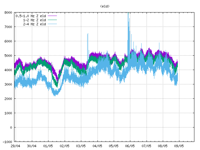 .
.
Why is this site dropping this link: “http://hraun.vedur.is/ja/oroi/eld.xxx”? Is it because it’s not https or because the xxx is gif?
It’s because it is trying to embed an http non-secure image in a secure https page and that is not allowed. If you force your browser to http://www.volcanocafe.org/the-kilauea-dike-of-2024/ instead of https then you do see the image embedded. Here’s a copy of the latest chart you posted.
The birds on Eldey don’t seem to mind:
http://www.gannetlive.com/
BillG — thanks for the link!
22:11:37 2024-02-16 MAGNITUDE 3.23 mlw DEPTH 5.325km
AREA: Reykjaneshryggur – Eldey
NEAREST VOLC.SYSTEM:: 0.1 km. W from Eldey
Kilaueas summit GPS stations have moved apart by 10 cm since the intrusions stopped. UWEV has moved south by 5 cm during the intrusions and 1-2 cm north since then. CRIM has moved north during the intrusions by 10 cm and since moved south by 5 again, as well as 10 cm west which has been neutral since. But in both cases the movement during the intrusions has been recovered by half since then. If my number of 65 million m3 for the intrusion is used then that would be about 30 million m3 in about 2 weeks, or about 1 million m3/day. But it is probably too uncertain to be more than a guess on that.
The level of extension is also up to about the same level that the SWRZ started to get really active following the September eruption. So we might start seeing swarms of quakes there again this week, and strong tilting at SDH. How long it takes to intrude again will be interesting now the first break has happened.
Looking at the Eldvorp ELDC GPS station elevation trace, I’d estimate we are still a couple weeks out from the next fissure eruption.
If the trend continues, there will be a month with two eruption. Maybe April?
The IMO just released an update and they said end of Feb or (first week of) March if inflation rates stay the same. https://en.vedur.is/about-imo/news/a-seismic-swarm-started-north-of-grindavik-last-night
I have heard 08/02 to 18/03 as a total range, but modtly 08/03-18/03 from the trend so far.
Chad:
Please explain? 08/02 ???
Was supposed to be 08/03, 8th March, but misclicked. I type basically everything I ever write on here with my phone.
Also in Australia the day is written before the month too. So Christmas is 25/12/2024 etc.
The recent eruption endet on Februar 9th. If we add 25 days, we get to 6th March. +25 days lead to 1st April and 27th of April.
I assume that the duration of the eruptions is going to decrease to a single day. The trend has gone towards more short eruptions, but in the beginning with increasing output rate. They are becoming “Blitz Lava Flash Floods” that can be dangerous with their high speed and unprecitable direction.
The current activity/uplift we’re seeing north of Grandavik doesn’t, per IMO, seem to be occurring in the Fagra system (no uplift/inflation there). Also per IMO lava analysis (if I remember right), the two systems share a deep source.
Does this, perhaps, mean that Fagra’s supply is currently restricted, and thus we’re unlikely to see a Fagra eruption while the current area is active?
Unless, of course, the Icelandic Tourist Office intervenes and redirects the magma deep source back to the Fagra system? I suspect they’ll have to do so soon, because tourist season is coming in a couple of months 🙂
No idea what Fagradalsfjall will do. There is a small amount of inflation (& deflation, depending on which station you look at).
I interpreted the similar composition as that just being a common element of the deeper source region. Why it is apparently so different to the stuff that has erupted there the past few millennia I dont know, or even if that is actually true (or at least as big as it seems to be implied).
Fagradalsfjall also has at least so far had about a year between eruptions a bit less closer to 11 months. The first magma intrusions in the modern episodes were under Svartsengi in 2020 and then started at Fagradalsfjall, with the long eruption in 2021 and another small intrusion over the new year, followed by inflation at Svartsengi and then nothing until the eruption of August 2022. Fagradalsfjall itself seems to have first woken up in 2017, and I remember reading about there being inflation (maybe sill emplacement) at Svartsengi and Krysuvik earlier in the 21st century.
If Fagradalsfjall is similarly cyclical in a broad way as Svartsengi is, then an eruption there might not be expected until around June. If an eruption doesnt happen in June or July then maybe it is fair to say it has been overtaken, but not yet I think.
But I think Fagradalsfjall has got much more to go before it can stop, all of the rifts in the last cycle erupted around 3-10x as much lava as the 2010 eruption, so either we are going to get a few decades of small eruptions building a long ridge of spatter cones or we get another eruption like 2021.
Same at Svartsengi, the Eldvorp eruptions in probably 1226 or after covered over 20 km2 with lava and erupted a significant volume offshore from a long fissure very like the one now, and likely also produced one of the large tephra eruptions in the VEI 3-4 range. On top of that was the eruptions of Illahraun and Arnarseturshraun which were probably some years later in 1240, and which erupted around 0.2 km3 of lava on their own. The Stampahraun eruptions right at the tip of the peninsula also had several powerful VEI 3-4 eruptions and fissure eruptions on land adjacent. It wouldnt surprise me of the total magma erupted from just the Reykjanes/Svartsengi(+Eldey?) system in the last cycle was approaching 1 km3. Krysuvik did something similar, two huge eruptions close together over 20 km of the fissure swarm from the south coast to just south of Reykjavik. And Brennisteinsfjoll likely erupted some 2 km3, though more slowly and continuously. So far this cycle we have two systems combined erupting less than 0.2 km3, both are just getting started and the others havent even joined the race yet…
Should be 2021 not 2010
Thanks Chad!
I too am puzzled by the chemistry difference between the middle ages “fires” and today’s “fires”. However, I’m clueless when it comes to interpreting meaning from the differing chemistry, other than to note that a common source should at least be similar.
I do recall, though, that the chemistry of Fagra’s eruptions changed significantly over time (and that was just during the 1st eruption) so I wonder just how different its last eruption was from middle ages lava. (I know Fagra itself didn’t erupt in the middle ages)
If there’s one deep (Moho-level) source, both for the current eruptions and the middle ages ones, could that explain why the middle ages “fires” seem (to my reading, anyhow) not to have been simultaneous at any two locations?
I think you’re right – we’ll know if Fagra does not erupt as expected.
I’d expect that Fagradalsfjall continues to erupt for decades. It’s possible that there also were intrusions during previous Fires periods. After 8,000 years the system has to erupt again. The eruption in 2022 and 2023 was very similar to Piton’s eruptions. They rather reminded to Hot Spot volcanism than to rift volcanism.
Without the glacier, Grimsvötn’s eruptions likely would also remind much to Piton’s eruptions. They would do a short fissure eruption that then concentrates on a main vent. The recurrence time of Grimsvötn reminds to Mauna Loa’s average timescales, but the behaviour and quantity is a bit different.
https://link.springer.com/article/10.1007/s00445-023-01641-4
Water content of the 2021 lava was higher than expected for a MORB total composition, so hints at significant plume interaction. Might also explain the lava fountains being so tall too.
2021 lava, and presumably all the lava since, had an Mg content of 9-10% whole rock, and on the lower end of that for the melt. So it is very hot and primitive. But lava of similar MgO content erupted at times in the last cycle, the bit that makes the new stuff weird is the high TiO2 and K2O for being a tholeiite basalt.
From how fast it flowed last eruption I expect the same shiny fluid lava that erupted in 2021 is the stuff accumulating under Svartsengi, although a bit evolved after a few years in the crust. The close up views of the a’a lava near the road really looks like wet sand, crystals in a very low viscosity liquid.
Really, the way the lava at Reykjanes is so hot and fluid compared even to a lot of the larger central volcanoes makes me wonder if it is at fast spreading ridges where modern komatiites could occasionally erupt. Holuhraun was around 1190 C despite crustal storage, and Kilaueas lava lakes are over 1200 C, so plumes are extremely hot, but also tend to make thick crust.
Maybe the spreading ridge north of the Galapagos could be a place to look for some ultramafic lava. Which might also mean it is extremely rare to get actual komatiite erupting above sea level. The stuff in Hawaii at similar temperatures was still basalt just very hot basalt.
It’s possible that the Moho magmatic roots for Svartsengi and Krysuvik lie below Fagradalsfjall and that under certain (unkown) circumstances Fagradalsfjall can participate in the Fires as we’ve experienced. I also wouldn’t exclude that Fagradalsfjall did intrusions during the Middle Age or Roman Age Fires.
The high Magnesium content reminds to similar eruptions on Kilauea, f.e. the early Pu’u O’o stage. It may indicate a breakthrough eruption of fast rising magma from very deep sources, that later is followed by magma accumulation in magma chambers/pockets that feed more classical Tholeitic magma.
How long does magma need to evolve from Fagra’s primitive magma to Svartsengi’s magma?
You needs very high mantle temperatures to form real komatite melts, starts to melt at 1800 c and I think 1900 c is the requirement for real hadean like komatites at the greenstone belts, very high in olivine that makes up a majorty of the minerals in that lava, and woud be a complete primodial melt. Still Hawaii is on the lower edge of Komatite mantle melting certainly is very hot there, at 1800 c you starts getting into that mantle territory. The real hot stuff under Hawaii is ”superheated mantle basalt” rather than a true komatite melt, still Pūhāhonu woud be looking like Liquid Iron when it erupted same with the deep stuff under Big Island if it erupted, but its thick stuff over it so erupts cooler. Hawaii is ultra hot.. but not quite yet komatitic in depth, but I imagine Pele having magmas deep down being like hot hadean moon magmas lunar stuff that flowed white hot and like water almost, Pele is very warm for soure at depth, the main magma conduit is under Mauna Loa and should take a few years for magma to rise up from the hot astenosphere up to the surface
Had Hawaii been on thinner litosphere things coud get rather intresting as its not 100 kilometers to go upwards, but the litosphere is more or less burned away at Big Island replaced with superhot ductile stuff. But it woud build enormous volcanoes and crustal accumulating zones for magma thickeing the area even in a thinner litosphere so magmas woud still cool on the way up. Placing Pele at a MAR ridge woud just result the hot stuff being trapped in the deep rifts and you gets an Iceland
CJ:
Now go easy on them, as actually they did a really good job when the November dike event occurred and many people were afraid and they had to calm everyone down. A sudden 8 meter dike emplacment and > 7000 m^3 / sec magma flow is no small potoatoes. 🙂
Randal, I wasn’t implying anyuthing untoward about IMO, or the great work done by other authorities who diverted lava via the berms. I think they did great overall.
I was speculating about volcanic management by a different agency, ITB (Icelandic Tourist Board), and not lava diversion, but deep magma diversion (many miles down). Fagradalsfjall is, after all, a tourist volcano, and thus part of their domain. I figured they’d want it erupting in tourist season, and would divert (probably via moving the deep end of the conduit at about 20kn depth) the magma source away from Svartsengi and to Fagradalsfjall if it’s a shared source, to ensure that the latter, not the former, is the one erupting in tourist season. 🙂
A bit gassy this am?
Source: https://www.livefromiceland.is/webcams/fagradalsfjall
How strong has an eruption to be to cause a volcanic night? Major plinian eruptions can darken the sky so much that at noon it’s black like at night. The expansion of the black ash cloud can look a like moon’s shadow during a solar ecplipse or the invasion by one of Roland Emmerich’s giant spacecrafts (Independence Day). 1991 Pinatubo caused a volcanic night for 36 hours. How dark was it below the ash plumes of Eyyjafjallajökull and Grimsvötn?
I’ve seen videos of “life” in the eruption cloud of Grimsvötn 2011. It was pitch black.
Grimsvötn 2011 https://youtu.be/F224w2qVL0U?t=31
Not sure how to post a link here, so forgive me if that doesn’t come out right :-O
Thank-you Bjarki and Velvakandi! The videos give a good impression about the darkness during Grimsvötn’s VEI4 eruption. They show that a VEI4 is strong enough for this. Maybe in some short intense cases even a VEI3 with high eruption rate can do a short volcanic night. But a VEI4 is more sustainable for more hours.
Have you ever personally experienced the shadow of an ash cloud?
I’ve been going back and forth between Iceland and Germany very regularly for almost 25 years (family ties and a growing amount of friends in Iceland keep drawing me back, the astoundingly beautiful landscape is just the icing on the cake) and have so far always missed the eruptions, sometimes only by a few days *lol* The only one I have ever “been to” was Hóluhraun, but it specifically flew to Iceland to see it, because I’d won a sightseeing flight over the eruption with Mýflug on Facebook 😉 That was actually very cool, probably one of the most amazing things I’ve ever seen. But not an ashy eruption, that one. So, I guess that’s a no to experiencing volcanic night from my side.
But I do remember all the dashcam videos from Grimsvötn in 2011. It was scary, not something you’d want to experience.
Most Icelandic eruptions are short, they are easily to miss for tourists and part-time Icelanders. Holohraun and Eyyjafjallajökull were relativ long lasting eruptions.
I have the memory that I saw TV clips during Icelandic eruptions with ash fall and darkness, but it’s likely too long ago to find records again. Grimsvötn 2011 was sufficient for a volcanic night. Next Hekla and Katla eruptions likely are going to do big ash plumes as well. 2000 Hekla’s explosive phase was short, because the break since 1990 was short. But the longer Hekla waits, the bigger likely becomes the explosive phase.
I expect that the next Grimsvötn eruption remains a local tephra event. The eruption 2011 was extraordinary. The next significant ash eruption is likely going happen as a Surtseyan eruption of Eldey or Reykjanes, maybe VEI2-3, but too weak for a volcanic night.
Hekla seems to do a short explosive stage on all of its eruptions, the large 1947 eruption was only 1 hour of plinian activity that was then followed by violent fountaining as the fissure opened more. Long lived eruptions at Hekla are effusive, the explosive part seems always short, only the volume is larger for eruptions after long intervals or with large total volume.
Katla seems to top out at a mid sized VEI 4, the eruptions it has done that are larger than this historically have been long lived, so basically a larger version of what Eyjafjallajokull did in 2010, rather than a real plinian eruption. The major exception to this is Eldgja of course but that is a bit different and not likely to repeat soon. But a particularly intense VEI 4 might still block out the sun locally, as it did in 2011. I have more expectation of Katla doing something like that than I do for Grimsvotn doing it in its next eruption.
Yes, the explosive image of Hekla is a bit confusing, because the eruptions typically are mostly effusive. The beginning of Hekla’s eruptions is explosive and dangerous, but afterwards it quickly changes to fissure eruptions (hawaiian-strombolian character). Only rare silicic eruptions of Hekla can be mainly explosive, but they are an excemption during Holocene.
Grimsvötn is a bit exhausted by both 2011 and Bardarbunga’s 2014 eruptions. It likely has to do some small eruptions like 1983 before it in more distant future does moderate or large eruptions again. There exists also the possibility for purely subglacial eruptions with jökulhlaup that would be a bit boring for us, but Reykjanes Fires would compensate. Historically there were several of such “uncertain events” when there was some unrest and a jökulhlaup, but no tephra eruption.
Hekla is also weird because it was originally just explosive, while large volume effusive eruptions happened on the fissure swarm. But more recently and especially after 1158 Hekla itself has beem much more effusive despite still beginning with explosive eruptions. The fissure swarm is what Carl has said is a separate volcano called Vatnafjoll, which is the name of a subglacial ridge within the swarm. But after doing research and mapping the flows of both volcanoes where possible it just doesnt seem possible for the two to be completely separate, it appears to just be a fissure swarm that has recently evolved a central volcano. Dikes do form outside of Hekla on the fissure swarm though, and I have wondered if that is related to the activity at Reykjanes, being at the other end of the transform fault. Obviously not exclusively but with the recent intense activity at Reykjanes now one has to wonder
The last eruption I remember causing a dark sky effect was the La Soufriere St. Vincent eruption in 2021. Was honestly both mesmerising and frightening for the islanders. Had volcanic lightning too.
This was one of the last major dry (non-phreatomagmatic) global plinian eruptions. This eruption was surprising for me, because for long time it was an effusive dome eruption that grew slowly without any visible significant threat. Was it a typical eruption for the Caribbean Volcanic Arc? It was different to the classical Pelean eruption, but also different to many Plinian eruptions of the “Ring of Pacific Fires”.
Seems it is at least common, the eruptions on both Martinique and St Vincent in 1902 were domes that exploded. I think that is actually what a Peleean eruption is supposed to be, an exploding lava dome but now the term basically refers to any eruption making a dome that collapses at any scale to make pyroclastic flows, or lava accumulated on steep slopes (which dont require viscous lava either, many basaltic stratovolcanoes do this too).
The last big exploding dome eruption was at Shevluch last year, also a VEI 4. Before St Vincent in 2021 was probably Kelud in 2014, which was nearly a VEI 5. And before that maybe Merapi in 2010 although I am not sure of that. They are not rare but also not yearly events typically, so when they do occur they are likely to be the largest eruption of the year. Most VEI 4s are more like extreme lava fountains and occur at volcanoes with mafic magma, even very fluid lava in some cases. That is the case of the recent VEI 4s at Ulawun, Manam and Raikoke, all basaltic stratovolcanoes, and also Grimsvotn, Taal, Nabro and Fukutoku Oka Noba, which are all mafic or intermediate calderas at present. It is also the case for Hunga Tonga Hunga Ha’apai, which was basaltic andesite.
Basalt has the opportunity that it doesn’t need to evolve over long time to do an eruption (unlike f.e. Dacite). Is this a reason why Basalt often does explosive volcanoes? I see three reasons for explosive Basaltic eruptions.
1. Fast rising gasrich magma (like some maar explosions)
2. Cold basaltic magma that becomes viscous
3. Phreatomagmatic eruptions or water loaded Basalt
On my first visit to Iceland, back in August 2014, I visited an exhibition of photos during one of the Eyjafjallajokull eruptions. The ash made it very dark, to the point of the photos being very grainy and slightly blurred. At first glance, the technical quality was low, but they showed the atmosphere and conditions perfectly, much mire so than if they were perfect quality. I actually don’t know how many people would cope.
The Eyyjafjallajökull explosive eruption lasted for long time from 14th April to 9th July 2010. 2011 Grimsvötn was only seven days. Eyyjafjallajökull had a long time to make a continuing Plinian eruption with changing weather situations. It gave many opportunities for photos. Here is a photo from European Environment Agency gives a good impression of Eyyja’s ash plume, we can imagine how dark it was below the plume.
https://www.eea.europa.eu/de/about-us/what/public-events/wettbewerbe/imaginair-fotostory-wettbewerb/eyjafjallajokull-vulkan-island/image
SWRZ quakes are starting to happen at Kilauea again. Just low rate in the upper SWRZ connector for now but that will likely change
BillG (16/02/2024 at 19:03):
> The birds on Eldey don’t seem to mind:
> http://www.gannetlive.com/
I don’t know why (a link to) a webcam showing birds on essentially hopping on dirty ground on a far-flung island fills my heart with a bit of happiness on an otherwise bleak day. It must be the magic of Volcanocafe!
Actually, here, I can not not mention the brilliant seabird book by Adam Nicolson on “The Lives and Loves of Puffins, Gannets and Other Ocean Voyagers”. Not too much volcano content in it, but I still know many or most VC enthusiasts would love it anyway.
Road repairs in Iceland – these people do not procrastinate!
https://www-vf-is.translate.goog/frettir/vinna-ad-gerd-nys-vegar-innan-varnargarda-vid-svartsengi?_x_tr_sl=auto&_x_tr_tl=en&_x_tr_hl=en-US&_x_tr_pto=wapp
Exerpt: “A temperature sensor was placed by the road yesterday to monitor the temperature there, which is between 50-80°C. However, the temperature is lower on the surface of the road.”
Tempting fate?
Grindavíkings can now stay in Grindavík 24/7 at their own risk, although overnight stays are not recommended.
Source: https://www.ruv.is/frettir/innlent/2024-02-19-heimilt-ad-dvelja-og-starfa-i-grindavik-allan-solarhringinn-405328
It is not expected that many would take up the offer. But there were c.900 in the town (from memory) when the volcano erupted recently. While they got out safely then, the volcano is likely to give much less warning next time.
Correction: c,200 people in the town on 14th January 2024.
It would be helpfull if they wear like Maurice and Katia Krafft 1973 on Eldfell: https://www.youtube.com/watch?v=8SIUeLphLyI
Video https://twitter.com/hermesisos/status/1759235362323304539 “18 February 2024 Krasnodar Russia
Mud volcanoes have erupted in the Sea of Azov, located between Russia and Ukraine. Boilings and volcanic eruptions occur in the region.”
Toss in a match and watch the fireworks….
Talking about ash clouds making things dark, certain areas of WA state got dark after Mt St Helen’s blew up. See
Thank-you for the photo, Randall! St. Helens is a good example for a major Plinian eruption. The ash clouds in the photo look like thunderstorm clouds that are able to do Tornados.
This photo was likely shot during the famous eruption on May 18th 1980. The same year another five plinian eruptions happened on St. Helens that likely did volcanic nights around St. Helens. GVP lists them as VEI3 eruptions, so the VEI5 classification is only related to May 18th?
Updated hazard map from IMO: west of Þorbjörn and Grindavík, yellow, but the zone has been extended southwestwards; and east of Þorbjörn, including Grindavík, orange.
Another eruption is expected late February / early March.
New post is up! Where M stands for Magma
https://www.volcanocafe.org/m-stands-for-magma-the-socorro-cover-up/