2023 has been a lively year for Kilauea volcano. While the arguably most active volcano in the world is always doing something, this year has been particularly dynamic. So far it has produced 3 brief but spectacular eruptions at the summit crater: the January 5, June 7, and September 11 outbreaks. Apart from the eruptions, this year has also featured a few small non-eruptive intrusions, the ubiquitous deflation-inflation events, and episodes of rapid uplift and earthquakes shifting between the summit crater of Halema’uma’u and the upper Southwest Rift Zone (SWRZ). It is this rift zone that since August has dominated Kilauea discussion in the chat. This is an article where I talked about the August-September SWRZ activity that has continued afterwards:
With Halema’uma’u not far from returning to the inflation level it had before its last eruption and the very intense ongoing unrest along the SWRZ, I can’t help but wonder if 2023 will have a final event at Kilauea. It is about time, and it feels like things are reaching their breaking point. It might be Halema’uma’u or it might be the SWRZ, it might be tomorrow or in a few months, but I doubt Kilauea will stay put for much longer. It has been a little over 40 years since the Southwest Rift Zone of Kilauea last produced a dike intrusion and about 50 years since its last eruption. So I think it is a good time to explain the SWRZ, and why there are actually 3 of them.
The earthquakes
The plumbing of a volcano runs below the surface where we cannot see what’s happening. So how do we know what’s there? Seismology can give us a hand here, earthquakes happen along faults, which are often related to magma structures within a volcano. Kilauea is a great example of this. And in particular, the SWRZ is very seismically active. Kilauea can undergo periods of a few months where unrest happens along this rift zone, usually consisting of a combination of inflation and earthquakes. The ongoing unrest is an example of this. The USGS earthquake catalog includes 1300 SWRZ earthquakes since August of this year, which have been concurrent with up to 25 cm of ground uplift southwest of the caldera, and affecting an area several kilometers across. Another important episode of unrest, that shares similarities to the present one, preceded and followed the last dike intrusion (rifting event) of the SWRZ, which happened in 1981. Below I show the located earthquakes this year since August 13, and also the earthquakes from the beginning of 1981 until just before the SWRZ dike intrusion of August 10 that year.

Earthquake data comes from the USGS catalog.

Earthquake data comes from the USGS catalog.

Schematic map of the earthquake clusters that are regularly active, and some of the important volcanic vents in the area.
Most of the earthquakes in the SWRZ occur in clusters 2-3 km deep below the surface. This is more or less the limit between the deep, permanently molten plumbing system of Kilauea, and the solid rock cap above this plumbing that is often intruded by dikes. I believe many of the clusters might be earthquake swarms within the rock cap just above quasi-perpetual dike-like magma bodies that form the internal magmatic architecture of the Kilauea volcano. The reason that the three different parallel rifting sections exist in the SWRZ would be due to this complicated architecture.
The northern strand, the Volcanic SWRZ, or the Halema’umau’u dike swarm
The first subsection of the SWRZ is usually known as the Volcanic SWRZ. I think this name can be a little misleading though, since it is not any more volcanic than the others. Robin T. Holcomb described in his article, Eruptive history and long-term behavior of Kilauea Volcano, the three “strands” of the SWRZ, the same ones I’m writing about here. In this article, he refers to it as the northern strand since it is the most northerly one.
I like to think of it as the Halema’uma’u dike swarm. Given that it is a group of dikes fed from Halema’uma’u, the central vent of Kilauea, that often forms a crater or lava lake at the summit. There have been four eruptions in this swarm historically, in 1823, 1868, 1919-1920, and 1971. The 1919-1920 eruption formed the satellite shield volcano of Mauna Iki, some 10 km downrift of Halema’uma’u. The 1971 eruption rifted right across Mauna Iki, and produced a near-continuous 8-km long eruptive fissure, but only lasted 5 days in total. The 1868 eruption erupted downrift of Mauna Iki along roughly the same line and was triggered by a M 7.9 earthquake under the south flank of Hawaii, it caused much of the summit caldera to sag in dramatically. The 1919-1920 Mauna Iki eruption is a good example of how this swarm functions and was well observed.

The events of 1919-1920 occurred with a long-lived lava lake at Halema’uma’u. Before rifting, the lava lake was perched 2 meters above the surrounding ground, contained by levees, short overflows spilled over the levees and slowly built a shield around the lake. Events took a turn on November 28, 1919. It was around 2 AM in the morning when the lake started to quickly drain away, 70 earthquakes were felt in a 2-hour time span as the lake quickly receded to a depth of 180 meters, leaving a cylindric crater up to 370 meters wide. Two cracks in the lower 100 meters of the SW and NE pit walls appeared. In light of later events, the conduit walls had ruptured and magma had drained into the rift.
Halema’uma’u lava lake in Kilauea Caldera in 1894. It would have looked similar in 1919. 1894, Howard Hitchcock.
For the next 17 days, the lava lake surface rose again in the pit. By the morning of December 15, the lava lake had refilled almost entirely and was 11 meters below the rim. At 11.25 AM that day, lava erupted from fractures near the SW caldera rim that had opened on November 18. These fractures were 15 meters below the elevation of the Halema’uma’u pit rim and the lava could be seen flowing through fractures from the lava lake towards the SW caldera rim. The eruption ended but the lava lake continued to drop, about 45 meters down in a day. The lava lake started to refill again, while at the same time, cracks started to propagate down the Southwest Rift Zone for several days. Some of the cracks emitted steam and others had visible lava flowing through them. On December 19, the Halema’uma’u lava lake had risen to the elevation of the SW caldera vents and they started erupting again.
On December 24, lava broke out from the area that was to become the Mauna Iki shield volcano, 10 km downrift from the lava lake. Mauna Iki erupted until August 1920. It developed a summit lava pond, overflows constructed a shield around the this, and lava tubes channeled lava over long distances from the shield into expanding fields of tube-fed pahoehoe. The Halema’uma’u lava lake remained high throughout the Mauna Iki eruption. Because the lava was previously degassed by the summit lava lake, Mauna Iki did not produce lava fountains nor build a cone.
Eruptions from the northern strand of the SWRZ are fed from Halema’uma’u. Some eruptions happen at times when there is no summit lava lake and feature lava fountains with the construction of spatter ramparts or low pyroclastic mounds, like in 1971, or the prehistoric eruption of Cone Peak which is aligned with the 1971 fissures. Mauna Iki instead erupted degassed lava from the summit lake. There is another very similar-looking shield 6 km downrift of Mauna Iki, that is thought to be several centuries old and must have formed in a similar eruption.
In 1822-1823 a complex episode of dike intrusions and at least two eruptive outbreaks took place, which formed a system of cracks over 30 km long down to the sea, in places a collapsed chasm 20 meters across known as the Great Crack. In 1823 lava broke out from the lowest part of this crack, draining out a massive caldera-wide lava lake that existed at the summit. It was a massive flood-like eruption that ran into the sea over a 6 km long strip of coast making submarine lava deltas offshore. The lava was completely degassed, with no trace of sulfur or pyroclastic material in the vents. It was a large event, although I don’t know exactly how much, but probably more important than any other historical SWRZ eruption. This is a story to be told in more detail some other time, along with explosive eruptions, colossal lava lakes, and rift drainouts that plagued the 1790-1840 years of Kilauea.
The middle strand, the Seismic SWRZ, or the Puu Koae dike swarm
To the south of the Halema’uma’u swarm runs another line of fissures which has only erupted once historically, in December 1974. The middle strand of Holcomb has been intruded by dikes 3 times in the past several decades, in 1963, 1974, and 1981. It is also characterized by frequent seismic swarms, hence it is often called the Seismic SWRZ. I think of it as the Puu Koae dike swarm, because the most prominent cone here is known as Puu Koae.
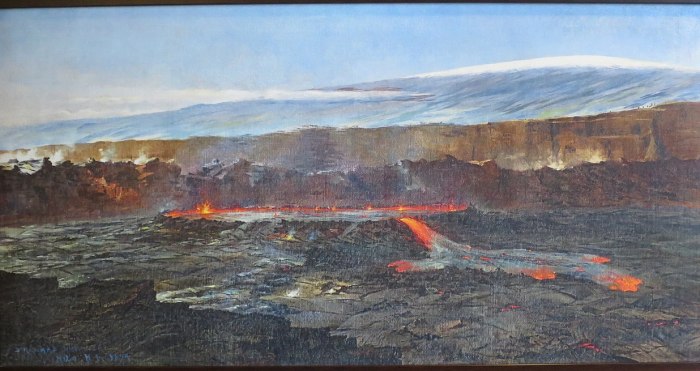
The December 1974 eruption was preceded by 3 months of rapid inflation. During this time earthquakes were also recurrent along the SWRZ. In the Upper SWRZ, SE of the future 1974 fissures, and in the Kulanaokuaiki area. These earthquakes were probably triggered by magma seeping below the surface into satellite magma bodies of Kilauea. On the evening of December 30, microearthquakes were occurring every minute in the SWRZ. Just after midnight, the summit tiltmeter began to show a precipitous deflation, something had broken, and magma was draining from the summit storage into the rift. Earthquakes sharply increased in the Upper SWRZ, 2-3 km south of Halema’uma’u, at this time. Just before 3 AM lava fountains were first sighted. Fractures opened ahead of the fountains along with sharp cracking sounds, they started to steam and within minutes lava fountains bursted out of these cracks. A fire curtain was developing, and by 5 AM a 3-4 km long section of the rift had unzipped and was spouting lava to heights of up to 100 meters, with many parallel en-chelon erupting fissures. Fast-flowing pahoehoe lava was spreading out over the landscape, eddies played in the currents, and crustal places were constantly forming and breaking up over the thin glassy skin. Fountains started to decline, by 8:50 AM the eruption was over. The eruption formed a 13 km-long braided channel system, with fluid lava mostly less than 1 meter thick consisting of sheet pahoehoe as far as 9 km from the vents, and thin aa lava with glassy crustal plates near the flow tip and along the main lava channel.
The flow bears a flood-like appearance due to the fast emplacement and high fluidity of the lava. December 1974 lavas contain about 13 wt% magnesium oxide, which is much higher than normal basalt and one of the most primitive lavas to have erupted from Kilauea, which may explain their fluid appearance. The dike may have drawn magma from deep sills that run from the summit to the SW and which often experience inflation, for example, the 25 cm inflation since August of this year is focused near the 1974 fissures, these sills contained more primitive magma that the shallower sills under the caldera that fed other less primitive eruptions that year. The magnesium oxide had also been rising for years beforehand and had been very high during a 1968 upper ERZ eruption, and the Mauna Ulu eruption of 1969-1974. This increase in the primitiveness of Kilauea’s magmas perhaps climaxed in 1974.

The 31 December 1974 eruption. Photo by Robin Holcomb, USGS.
The dike continued to grow after the December 31 eruption and at 4 PM earthquake activity had reached 15 km downrift from the starting location of the swarm, achieving its full length. For more than 10 days the summit continued deflating and earthquake activity happened mostly along the distal parts of the dike intrusion, also triggering faults down to the coast of the island along the western boundary of Kilauea’s mobile flank, as the rock adapted to the newly arrived material. From its size, I expect the volume of the 1974 dike greatly surpasses that of the “small” 6 million cubic meter lava outbreak, so that it was a dominantly intrusive, endogenous event.
On August 10, 1981, another dike intrusion started from the same area as that of the 1974 event, followed a very similar path, and reached the same 15-km length. This was another important rifting event that drained a substantial amount of magma from the summit of Kilauea but did not erupt onto the surface. Another dike intrusion occurred here in May 1963 and cracked the ground for a distance of 5 km. It was associated with a smaller deflation of Kilauea’s summit and poorly located seismic activity. The 3 events affected the same middle strand of the rift and probably originated from magma storage in the Upper SWRZ. The map below shows earthquakes, ground cracks, and fissures associated with the three intrusion. The fissures of 1974 are offset from the earthquakes to the northwest. This often happens with Kilauea eruptions because the dikes can be inclined, they dip southwards, but the earthquakes happen along the base, so what you get is the deep earthquake expression of the dike happening along the base to the south and the surface eruptive fissure expression of the dike showing up to the north.

Green squares are earthquakes of the 1974 dike intrusion, the star shows the location of the initial swarming and lines the eruptive fissures. Pink squares are August 1981 dike earthquakes and the first events location. Light blue lines represent surface cracks of the May 1963 intrusion from HVO reports.
There are at least 4 prehistoric eruptions that have affected this same area between about 1500 and 1790 AD: two unnamed spatter ramparts, and the eruptions of Cone Crater, and Puu Koae. Puu Koae is the largest eruption here, it was a slightly long-lived eruption that formed a pyroclastic cone and several sluggish flows of aa lava. From its appearance, I get the impression that its basalt might be a little evolved compared to other Kilauea lavas.
The southern strand or the Kamakaia dike swarm
Three earthquake clusters, the ones I dubbed in the map at the beginning of the article as Kulanaokuaiki, Kamakaia, and Puu Kou clusters, are aligned with the direction of SWRZ dikes and they also match with a series of surface fractures and eruptive fissures that have not been active historically.
The Kulanaokuaiki cluster is located just SE of a large north-facing scarp, probably formed from inclined dike intrusions that lifted a block to their south and did not reach the surface. Some similar scarps further east have been historically ruptured by dikes from the East Rift Zone. Collectively these scarps form the so-called Koae Fault System. It is a vast area of failed dike intrusions that are seemingly doomed to never see the light of day. Summit overflows regularly add elevation to this region, so it is a bit higher than it would be if it was just a rift zone, dikes that form here from the rifts are apparently not pressurized enough to reach the surface. I believe the Kulanaokuaiki earthquakes cluster may have fed dikes in the past, akin to those of 1963 or 1981, which do not erupt.
The Kamakaia earthquake cluster is located right below the Kamakaia Hills, a curious group of 9 cones that is relatively isolated. The timing of the last Kamakaia eruption is known from stratigraphy: the Kamakaia Waena eruption overlies ash from 1790 but must predate the arrival of westerners in 1823, so it was erupted at some point between the two years. Kamakaia Waena was a sizable eruption that produced 0.1 km3 of lava, it lasted somewhere between a few months and a year, and eruption rates were low, making fields of tube-fed pahoehoe, and more rare aa and toothpaste lavas. But the rarity of this eruption is that lavas have a basaltic-andesite composition, with 4 wt% magnesium oxide, some of the most evolved lavas known to have erupted from Kilauea. The Kamakaia Hills are 14 km away from Halema’uma’u, and it is possible that the earthquake cluster under the cones shows the magma body that supplies the vents. The distal location of the magma body might allow the melt to evolve, similar to eruptions from the Lower ERZ and Puna Ridge which produce evolved basalts, but more extreme due to the lower activity of the SWRZ.
The youngest Kamakaia eruption has a few cones, one of which is a beautiful 40-meter-tall symmetrical cone formed in strombolian activity due to the sluggish lava, Kamakaia Waena. The Waena feeder dike rented a graben across an older cone Kamakaia Uka which has a remarkably identical appearance to Kamakaia Waena and was formed in an earlier long lived eruption. Kamaia Uka lavas overlie a cone formed during high lava fountains, perhaps 200 meters high or more, which is probably associated with a long fissure that runs downslope and features three other cones sticking out of younger lavas one of which also featured powerful lava fountain. A flood-like flow of aa lava with braided lava channels mostly buried under Kamakaia Waena lava shows up downslope, it is the result of what must have been a powerful fissure eruption which I suspect is the same eruption that formed the high fountain lava cones. In turn, the braided lava channels overlie summit overflows from the 15th century.

The blue squares represent earthquakes from the USGS catalog for the current unrest and that which preceded the 1981 dike. Lines show the various fissures and fractures associated with the southern strand of the SWRZ.
While the Kamakaia Hills have not experienced any historical (post-1823) eruptions, there was an unusual unrest episode in 1981, six months before the SWRZ dike intrusion. In February 1981, for a period of about 10 days, the summit of Kilauea started to gradually deflate, and at the same time, many earthquakes flared up the seismic clusters under the Kamakaia Hills and Puu Kou, while the rest of the volcano was quiet. Most likely magma accumulated beneath these areas. The Puu Kou cluster however included unusually deep events, with earthquakes up to 7 km below the surface, down to the base of of the volcanic pile and decollement fault, unlike the other much shallower swarming areas, This later area is also at the western limit of the mobile flank of Kilauea. The seismic area beneath Puu Kou I think is a triple junction between the vertical magmatic plumbing of the SWRZ, an area of faulting along the west end of the mobile flank of Kilauea, and the horizontal plane of the base of the volcanic pile on top of which the flank slides. It might also serve as an area that originates dike intrusions which might feed some low-elevation fissure vents dowrift of Puu Kou that belong to the southern strand of the SWRZ, like the Black Cone eruption, a small viscous-looking eruption that might have formed around the same time as Kamakaia Waena and is aligned with it but is 8 km further downrift. The Black Cone lava is a little more evolved than typical Kilauea lava, with a bit below 6 wt% magnesium oxide, if it drew magma from the same storage area as Kamakaia Waena it must have happened afterward so that the more evolved stuff had erupted out.

Map of Kilauea’s triple SWRZ
The next SWRZ eruption
The Southwest Rift Zone of Kilauea has been producing numerous small earthquakes for over 3 months now. Earthquakes have gradually extended downrift, first near the caldera rim, then lightning up the middle strand, the 1974 fissures area, and in recent weeks, the seismic clusters located beneath the southern strand of the SWRZ have become increasingly active. Halema’uma’u on the other hand is not having earthquake activity and the state of inflation is not yet that before the last eruption. So I think it’s possible that we will see an eruption or dike intrusion in the middle or southern strands of the SWRZ sometime soon. The area of Puu Koae and the 1974 fissures is higher in elevation than the caldera of Kilauea, so I don’t think a dike there will have enough pressure to erupt, and if that area snaps then we will have a non-eruptive dike like those of 1963 or 1981. The Kamakaia and Puu Kou clusters are however lower in elevation than the caldera floor, and an eruption there would be possible. In fact, it was a Kamakaia eruption the first flank eruption to occur on Kilauea after the large 1790 caldera collapse. If history repeats itself then the 2018 collapse could end up having a Kamakaia Hills eruption follow-up too. If this comes true then we would probably see an eruption that lasts months and produces lava that is more viscous than usual, with probably some Fissure 17-like strombolian activity. That said, if the SWRZ takes too long then Halema’uma’u will be the next place to erupt and the SWRZ activity will be delayed for another few months at least. Halema’uma’u will probably erupt in somewhere between a few weeks or a few months if the SWRZ does nothing.
References
Holcomb RT (1987). Eruptive history and long-term behavior of Kilauea Volcano. U.S. Geol. Surv. Prof. Pap. 1350
Hazlett, R. W., Orr, T. R., & Lundblad, S. (2019). Undocumented late 18th- to early 19th-century volcanic eruptions in the Southwest Rift Zone of Kīlauea Volcano, Hawai‘i. Scientific Investigations Report. https://doi.org/10.3133/sir20195010
Lockwood, J. P., Tilling, R. I., Holcomb, R. T., Klein, F. W., Okamura, A. T., & Peterson, D. W. (1999). Magma migration and resupply during the 1974 summit eruptions of Kilauea Volcano, Hawaii. U.S. Geological Survey Professional Paper. https://doi.org/10.3133/pp1613
Rowland, S. K., & Munro, D. C. (1993). The 1919?1920 eruption of Mauna Iki, Kilauea: chronology, geologic mapping, and magma transport mechanisms. Bulletin of Volcanology, 55(3), 190–203. https://doi.org/10.1007/bf00301516
*** Important – Dragon Breath Incoming ***
Dear all,
As we’re all aware, the IMO stopped providing the beach ball data to the https://vafri.is/quake site. There has been speculation as to the reasons for this, with one VC regular contacting the VC mailbox regarding this. While some of us found this data useful, I’m assuming the majority of visitors would not assign as much weight to this, if at all, with regard to satisfying their reasons for visiting the blog. We have had complaints from other VC regulars, about the ongoing speculation and displeasure at the IMO in the comments, from other commenters. Those who disagreed with the IMO, and their retraction of public data, have had their say, and no amount of grumbling on the blog is going to change that, I’m afraid.
The VC dragons have had a chat and we think this subject has reached its limit now – could we all refrain from any more discussion on it, please?
More details on this will be added to the next post.


SENG has made it back to zero (ar as near as)
Thanks for posting that Merlot. I had been wondering when it would get back pre-unrest statur=s. Apparently the inflow is still continuing but a slower rate and also some of the magma is making it into the previous channel that caused the Graben. Even the scientists don’t know what is like to happen from hereon in.
status = zero
Many flashing lighted vehicles blocking roads on the North and Northwest sides of Grindavik. Must have had some more real estate falling off into cracks and/or holes. Hope that’s limited.
New post is up! When small moons do big things
https://www.volcanocafe.org/a-quick-tour-of-volcanism-on-io/