In my previous article, here, I discussed how Kilauea and Mauna Loa volcanoes are connected to each other through the Pahala Swarm. Now I have to deal with a confrontation of theories that is inevitable. There is a classical model of how Hawaii works. It is all about the mantle plume. The classical view establishes that the different volcanoes have various magma chemistries which come from different parts of the plume, a mantle upwelling under Hawaii, and they follow vertical paths towards the individual volcanoes. Where is the problem? Mauna Loa and Kilauea have different chemistries. If they share the same magma source, which I’m quite convinced they do, then the classical model is wrong.
Nowadays no one dares go against the traditional view of how Hawaii works. But I will. I will explore the amazing possibilities that could come from a whole different way of thinking about Hawaiian volcanism. When all the magma comes from one.
The many paths of magma differentiation
As I pointed out in the preceding part of the this series, Kilauea has a highly variable magma supply. From 1840 to 1960 the supply was low. During this time certain elements, known as incompatible elements, increased their abundance in the magma. At the same time the Sr87/Sr86 isotopic ratio decreased, while the 206Pb/204Pb ratio increased. In other words the chemistry of the magma was shifting. During this time Mauna Loa was more active.
Something interesting happened in 1960. A large eruption took place in the East Rift Zone of Kilauea which used up so much magma that the summit nearly caldera-collapsed. This event produced an enormous amount of deflation. The next year a surge of magma came in which produced the highest levels of inflation ever recorded at Kilauea. The seismic pathways deep under the summit also reorganized. More east rift eruptions and intrusions followed in the next years. Ever since then, when not erupting, Kilauea inflates rapidly with magma. More so than in 1840-1950.

The summit of Kilauea starting to collapse in 1960. The not yet solid lava lake of 1952 is leaking into the collapsing crater. From USGS.
This seems to be a top-down process triggered by the 1960 eruption. What is interesting is that it affected the geochemistry enormously. All the trends drastically reversed. Since 1960 the incompatible element abundance of Kilauea has been decreasing while the Sr87/Sr86 ratio grows and the 206Pb/204Pb ratio falls. Or in other words, the volcanic processes affect the magma chemistry. Different chemistry thus doesn’t necessarily mean a different source but can also mean that the processes acting over the magma are not the same.
The incompatible elements are those that are left out from the crystallization process. Barium, Niobium or Lanthanum, for example, are some of the most incompatible. A magma that has undergone more crystallization is expected to be more enriched in them. They become concentrated in the remaining liquid. Here mushes might be important. Magma sponge? The rift zones are thought to be filled with these mushes. Because the rifts are continuously spreading enormous amounts of material go into them that never reach the surface. Excess incompatible elements might be expelled into the conduits or magma chambers during these processes. If magma has to reach Kilauea from Pahala through the southwest rift, then what happens to this magma as it moves underground through the rift zone? This is poorly understood. If anything is clear though it is that the faster the magma moves towards the surface the less enriched it would be. Slower would be more enriched in incompatible elements. What happened 1960 was a change in how fast magma rose into Kilauea, a transition from low to high supply, so that was possibly the reason for all the chemical changes it triggered.
Instead I don’t know much about the properties of the Sr87/Sr86 and 206Pb/204Pb ratios. How or why, or when they would change, I don’t know. I will have to explore this issue in the future. The events of 1960 do suggest however that they can also be altered by volcanic processes. Each Hawaiian volcano usually has particular isotopic ratios that distinguish them from each other. Mauna Loa and Kilauea have their own distinct ratios. This is usually assumed to mean that the magma source is different. I however would consider that like in 1960 there must be volcanic phenomena that alter these characteristics, and that it would rather be a difference in the way magma is transported towards the surface.
The one magma
Another type of geochemical variability that exists in Hawaii is the alkalinity. This refers to the amount of NaO2+K2O in the magma. Volcanic rocks are classified into different types depending on the alkalinity. The kinds of rock that Hawaiian central volcanoes commonly erupt are, in increasing order of alkalinity, increasing order of NaO2+K2O: tholeiite basalts, transitional basalts, alkali basalts and basanites.

Types of volcanic rocks depending on silica and alkali content. From Wikimedia by Woudloper.
As usual this is explained by these types originating from different parts of the mantle plume, with the central part generating the tholeiites, and the edges making the more alkaline types. Problem is that Mauna Loa and Kilauea have slightly different levels of alkalinity. And also I will be soon saying that Hualalai is connected to them, and Hualalai erupts transitional basalt. So I prefer alternate models.
All the types of magma erupted in the Hawaii Island could be obtained from an homogeneous melt similar to Mid-Ocean Ridge Basalts. It just depends on the minerals.
Hawaiian magma first crystallizes the mineral chromite, but it does so in insignificant amounts, second comes olivine, which is more important, then clinopyroxene, and then plagioclase, also important. The order has to do with the temperature. Olivine has about 40% silica, while clinopyroxene and plagioclase have around 52-53%. The parental magma is somewhere in between, around 47 % silica. This is a crossroad. If the magma crystallizes mostly olivine then it will increase in silica rapidly. If it crystallizes mostly clinopyroxene or plagioclase it will actually decrease in silica and move towards more alkaline compositions. Temperature could have a lot to do in shifting the process to one side or the other. Higher temperature would favour olivine. Depending on the amount of minerals of one type or the other that it forms, then it would result in a very wide range of alkalinity.
From this point of view the tholeiitic lavas erupted by Kilauea and Mauna Loa are tholeiite basalts that are almost unchanged from the original melt and have underwent only small amounts of olivine crystallization. The alkaline lavas of the older volcanoes would be more evolved and generated through a more clinopyroxene and plagioclase dominated fractionation. This also seems to be supported by how the amount of incompatible elements seems to be directly proportional to the level of alkalinity. The most ultramafic and alkaline magmas always are the most enriched. Presumably meaning they have underwent more crystallization.
The high concentration of incompatible elements in the basanites that Haleakala currently erupts suggest that about 75 % of the original magma could have crystallized, 25 % reaches the surface. The even higher enrichment of ultramafic nephelinites from the volcanic fields of Oahu would suggest that barely 3-7 % of the original magma has survived the journey there. Alkaline magmas also tend to concentrate water. I don’t if this is true for CO2 too.

Volcanic field eruptions of Oahu. Ultramafic nephelinite is frequent here. From Wikimedia by Mbz1.
To me it makes a lot of sense that some hawaiian volcanoes would carry melt more efficiently than other. For example Mauna Loa and Kilauea have mature plumbings, with central conduits, and magma chambers, and will carry the melt much more efficiently towards the surface than the mushy volcanic fields of Oahu. This should be reflected somehow in the chemistry. I think that alkalinity is the way this is reflected. In this theory not the source but rather the volcanic structures and processes would produce the different chemistries.
Both Kilauea and Mauna Loa are also known to have produced rare eruptions of alkali basalts from their flanks. This could happen when the magma bypasses the summit plumbing and instead rises through the rifts, which Loihi seems to demonstrate quite well, by erupting tholeiitic basalts from the summit, and both tholeiitic and alkali from the flanks. This I think argues against the classic mantle plume model for the magma generation. Instead it is more consistent with the different pathways taken.
Magma rhizomes
If Kilauea volcano feeds laterally from Pahala, 40 kilometres away, then it is also likely that other older Hawaiian volcanoes did the same. I have investigated this question and reached some interesting theories. The theory I’m going to show here might seem unnecessarily complicated, but it is the best way I know of explaining the different types of volcanoes in Hawaii, their timing, the relationship to each other and how the Mauna Loa-Pahala-Kilauea connection works. It explains A LOT.
A lot of insight came from comparing Kilauea to Piton de la Fournaise, a volcano near Madagascar. These two volcanoes are often considered as analogues to each other. There is one structure that I find particularly interesting. The northeast rift zone. This NE rift connects the two volcanoes of the island, the older Piton des Neiges to the northwest, and the younger Piton de la Fournaise to the southeast. The rift erupts lavas more alkaline than those of Piton de la Fournaise, meaning that it could be a deep structure that bypasses the summit. Earthquakes under the rift run at a depth of 20 kilometres, and marks a path leading to below the flank of Piton des Neiges edifice, here it descends to a depth of 30 kilometres, and when also considering that a lot of CO2 has been observed to be emitted by this rift, it does seem likely it represents the feeder path of Piton de la Fournaise. Does the younger volcano feed from the older one?

The two volcanoes of Reunion are connected by the NE rift of Piton de la Fournaise, Deep earthquake activity and gas emissions show that the NE rift is a magma pathway probably carrying malt towards Piton de La Fournaise. Created in Google Earth.
I imagine the rift zones as being similar to the rhizomes of plants, and the volcanoes being stems, a volcano can grow a rift laterally and then a second volcano might sprout from this rift system. So then what if some volcanoes can act as feeders to other volcanoes? What if this happens in Hawaii? It turns out this could provide the answer to many questions about Hawaiian volcanism that I had.
Volcanic Complexes
The construction of Hawaiian volcanoes doesn’t follow a perfect progression. One would expect that as the Pacific Plate moves over the Hawaii Hotspot it would make one volcano, then another, and another, and so on. But no. Actually it is more sequential, with one group of volcanoes growing during a certain period and then activity moving to the next group. I will call these volcanic complexes. I will call each complex after the volcano that I think was the first in each of them.
This is the timing of the main tholeiitic stage of each Hawaiian volcano of the past ~6 million years:
Loihi: Entering tholeiitic stage. New complex?
Hualalai Complex:
- Kilauea: 0.1 Ma-present.
- Mauna Loa: 0.47 Ma-present
- Hualalai: ?-0.1 Ma.
Mahukona Complex:
- Mauna Kea: ~0.7-0.4 Ma
- Kohala: 1.1-~0.5 Ma.
- Mahukona: ?-0.6 Ma
Lanai Complex:
- Haleakala: 1.9-1.25 Ma
- West Maui: 1.8-1.4 Ma
- Kahoolawe ?-~1.15 Ma
- Lanai: ?-1.3 Ma
Koolau Complex:
- East Molokai: Somewhere before 1.75 Ma
- West Molokai: ?-1.9 Ma
- Koolau: 3.2-1.8 Ma
Kaena Complex
- Waianae: 3.9-3.3 Ma
- W and E Kaena: ?-3.6 Ma
Lihue Complex:
- Kauai: 5.4-3.9 Ma
- Niihau: 5.5-4.7 Ma
- Kaula: ?
There are other reasons to think each of these groups are separate structures. The Lihue Complex forms a topographic seamount that is separated from the other volcanoes of Hawaii. There was a large shield volcano located in what is now the western side of Kauai Island, this was the Waimea shield. It is thought to have had a giant caldera 20 km across. The island of Niihau are the remnants of the Waimea’s rift zone. The rift runs in an east-west direction connecting the three volcanoes of the complex, with Waimea in the centre, linking to the Lihue shield volcano on the eastern side of Kauai, and to the Kaula volcano in the west. All part of one large structure.

Lihue volcano complex. Niihau is the rift zone of Waimea Shield Volcano, partly destroyed by landslides. From USGS.
Complexes usually share the same shoreline break, except the Mahukona Complex. What is a shoreline break? The enormous weight of Hawaiian volcanoes pushes them down into the Earth. As they are active they grow and make an island that keeps getting bigger, but afterwards they start waning and the island sinks into the ocean. The shoreline break is the ancient submerged coastline that marks where the edge of the island once stood. Each group seems to have roughly the same shoreline break which basically means that they rose and fell together.

The main shoreline breaks are shown in colours, they mark the size of the islands at their greatest extension. Each shoreline break seems linked to a particular complex. The volcanoes are represented as circles.
This is particularly impressive for the Lanai Complex. These four volcanoes grew to form the largest Hawaiian Island, of all times? It is called Maui Nui, meaning Great Maui. They were also joined to the emerged remnants of the Molokai volcanoes. At the time it was even bigger than the island that Pūhāhonu, the so called “Earth’s Biggest and Hottest Shield Volcano” created when it was erupting 13 million years ago. After Maui Nui became inactive it sank 2 kilometres into the crust, so that the saddles between the mountains were inundated, and the ancient landmass “broke” into the four islands of Molokai, Lanai, Kahoolawe and Maui.
Multiple volcanoes of each group often share landslide fans. For example the eastern side of the three Koolau Complex volcanoes collapsed in the Nuuanu-Wailau landslide complex, that with a volume of ~7000 km3 is among the largest on Earth. This makes sense, if the volcanoes grow together they should also reach gravitational instability together.

Nuuanu-Wailau landslide complex. From USGS.
So why the complexes? I speculate that each of these could be sharing the same magma feeder. Each group of 3-4 volcanoes would feed from one specific spot that was originally melted by the hotspot. Magma would travel sideways using the rifts. I have confirmed that the rift orientations of the volcanoes in each complex could potentially intersect with each other providing a network of magma passages between the various volcanoes of the complex. I will look more into this aspect in the next post where I will explain how the ancient rift of Mauna Loa, the Ninole Hills Rift connects with Pahala, which in turn connects to Kilauea through the Southwest Rift. Pahala being a junction in the rift network.

Each complex of volcanoes and its rift zones. Created in Google Earth.
I should also mention that there is a large active volcanic area that covers the northern islands, and an additional extension of the abyssal plains to the north. The North Hawaiian Arch Volcanic Field, it is among the few largest volcanic fields of the world. Some of its submarine eruptions are estimated at 40-70 km3. It generally erupts basanites or nephelinites. I don’t think it was created by the hotspot, while its exact age is not known it was already active when the Koolau volcano complex grew, because the debris of the landslides covers some of the lava flows. It still remains active, so it is fixed to the plate and not the mantle, and much of it is significantly off-track from the hotspot too.
One theory is that it is produced by flexure of the lithosphere around the load of the islands, so that it is pushed up and and undergoes decompression melting. I find the decompression effect very small though, about 1 km of uplift which is not much. In comparison lithospheric extension can cause the mantle to rise in the order of tens of kilometres. The eruptions also sometimes happen within areas that have actually subsided, like Kauai or Oahu.
So I find it most likely to be a tectonic feature. Volcanism strengthened enormously from Lihue to Lanai volcanoes, as the hotspot and the volcanic field met. So there may have been some tectonic-hotspot interaction in the recent pulse of volcanic activity of Hawaii.
Cyclic volcanoes
The idea that multiple volcanoes feed from the same magma feeder also provides an explanation to the different types of volcanoes that exist in Hawaii. Central volcanoes come in 2 types.
Most are covered entirely in tholeiitic basalts, or tholeiitic plus transitional, with only sometimes minuscule amounts of alkaline lavas, and they have low slopes.
Some have instead erupted large volumes of viscous alkalic lavas sometimes completely mantling the tholeiite lavas in all subaerial exposures, this gives them a more stratovolcano-like shape. It turns out that there is one stratovolcanish system in each the Mahukona, Lanai, Koolau and Kaena complexes. These are Mauna Kea, Haleakala, East Molokai and Waianae volcanoes. These four have erupted the vast majority of the alkaline lavas among the central volcanoes of Hawaii. They are the highest and steepest and must have at some point towered proudly above all others, majestically like Mauna Kea, the white mountain, does today:

Topographic shape of each complex. They are not to scale respect to each other but rather are intended to show the similarities in slope steepness patterns and relative heights of the volcanoes within each complex compared to the others.
The Lihue complex also has its own alkalic volcano, Kaula, which erupted phonolites, some of the most alkaline and silicic lavas of Hawaii. Kaula is very small though compared to its younger counterparts. Still, each complex has one.
In the Hualalai complex there are also some differences in the alkalinity. The most surprising is that while Kilauea is the more active, more powerful volcano, its lavas are actually slightly more alkaline than those of Mauna Loa. Alkalinity is related to the waning of the volcanic system and also as I’ve argued probably to lower temperatures and clinopyroxene/plagioclase crystallization. Why does the more active volcano erupt more alkaline lavas? There is also a difference in the amount of incompatible elements, which are higher in Kilauea. If the magma moves laterally, like from Pahala, and beyond, it might lose some of its heat, or crystallize more, interact with the rift, and make the magmas more incompatible element enriched, and more alkaline.
These gradients are roughly seen in all the complexes. In the Lanai complex, one end erupted the strongest tholeiitic lavas of Hawaii, the basalts of Lanai. The opposite end is truly the inverse with the most alkaline lavas of all Hawaiian central volcanoes, the basanites of Haleakala. Even in its peak tholeiitic stage Haleakala had twice as much incompatible element contents of Barium and Niobium compared to Lanai. As I will show these gradients also show in the isotope ratios erupted by each volcano.

Mauna Kea. A final volcano type. From Wikimedia by Nula666.
My theory is the following. The hotspot melts an initial volcano, like Lanai. The initial volcano develops a rift system which branches and propagates, the volcanic activity migrates with the propagating rift so that new volcanoes are created. Haleakala is an example of a final volcano, the one which is situated in the propagating end of the rift. When the next complex arises, the previous complex wanes. The waning complex will become increasingly alkalic due to the death and freezing of the plumbing system. These alkalic magmas will be provided mostly to the volcano at the propagating side of the rift system, the final volcano, like Haleakala, will erupt most alkaline lavas. If this is true then the volcano progression would be something like this:
Lihue>Waimea>Kaula
W Kaena>E Kaena>Waianae
Koolau>W Molokai>E Molokai
Lanai>Kahoolawe>W Maui>Haleakala
Mahukona>Kohala>Mauna Kea
Hualalai>Mauna Loa>Kilauea
Magma would be transported from the initial volcano to the final creating a gradient in the chemical composition.

The complexes compared to the inferred rift propagation and hotspot track. Created in Google Earth.
This could explain some interesting landforms of Hawaii. Particularly the Hawaiian Moat. The moat or through is a depressed area of the ocean floor that is located on the eastern side of Hawaii. But why the eastern? This is might seem like a silly detail, however this detail had me quite intrigued for some time. The last 5 complexes have all grown eastward/southeastward, perhaps because they influence each other to follow similar directions. If the edifices of each complex build on top of each other then a lot more piled-up weight will end up on the eastern side, thus depressing mostly that part.

From USGS.
There are 4 prominent rift zones that emerge eastwards from the moat side of the islands. The Pauwela Ridge, the Hana Ridge, the Hilo Ridge and the Puna Ridge. Each emerges from one of the last 4 complexes. I think that these rifts are the propagating tips of the branching rift systems of each complexes, they are seen best where they erupt underwater and make steep ridges.
The isotopic ratios
Lastly there is one other geochemical characteristic of the magmas that could be related to the complexes. Hawaiian volcanoes show different isotopic ratios. When the volcanoes are plotted one complex after another and in the order in which the complex seems to have grown, in which the rift has propagated, there are some interesting gradients that show up. It seems to me that as magma is transported laterally it might be affecting the isotopic ratios too and causing their variation among Hawaiian volcanoes. I don’t know however which mechanisms could be affecting them.

Ranges of 87Sr/86Sr isotope ratios in the volcanoes of Hawaii.

206Pb/204Pb isotopic ratio ranges in the volcanoes of Hawaii.
In the next part I will be looking at how rift zones work and how Kilauea was born.


.jpg#/media/File:Mauna_Kea_from_Mauna_Loa_Observatory,_Hawaii_-_20100913.jpg)
Wow! Thank you for this article. The chart of lava types alone is worth the read. You have put a lot of good stuff into this article! Great job, Héctor
Héctor great job…. really enjoyed this. i think You made very reasonable arguments and supported all Your ideas well. (and again, like Albert) i could ‘see’ what was happening from Your discriptions. Thanks!
Thank you, Héctor! Your article is one of those types that, as I read it, I think: “wow – this makes absolute sense.”
The way you put it, it all fits neatly and puts a lot of pieces in the Hawaiian puzzle in place.
It would also be interesting also to think about how sea level changes in glaciations and warm periods may have added to the older island erosion processes. But let’s leave that for another time!
Brilliant work, Héctor. Thank you!
Spectacular arguments! Have you put this in the peer reviewed lit? I’d love to read it in the more technical flavor favored by those journals as well as this superbly conversational tone.
Watching the volcano grow in Iceland really makes me think of all the plumbing in more mature systems as they grow. Even now many tubes and transport cracks leading from the main source are invisible to us under a layer of crust. It seems to be a scaled down version (with many fewer mechanisms at play) of larger volcanic systems. Fascinating to watch it grow and evolve with time.
Thanks Jazz_chi.
No, I haven’t submitted it to any peer-reviewed journal. But that would be an interesting possibility for the future.
Absolutely fantastic and facinating article, thank you!
This is really ground-breaking work Hector, a totally new way of thinking about the mystery that is the Hawaii hotspot. I just re-read the article Bagana: Child Volcano and there is again a similar process at work, shared magma pathways following a rift, perhaps even the new volcano stealing from the old (Bagana and Billy Mitchell, Kilauea and Mauna Loa). Perhaps magma complexes are more common than we thought and only the uppermost chambers are independent to the individual volcano(es).
Extremely thought-provoking! 🙂
Wednesday
30.06.2021 20:35:57 64.670 -17.440 3.4 km 3.2 99.0 5.3 km NE of Bárðarbunga
I guess this means Kilauea is probably going to turn into a real colossus, towering over the ocean, glaciated even in the tropics.
Visir cam showing continuous outflow when visibility permits, some minor fountaining. Looks to be less volume but it may be we’re just seeing the top of the exit channel.
Here, Dragons – get your teeth into this
“A revolutionary new geological theory has proposed that Iceland is just the tip of a vast, sunken continent — a fragment of the former supercontinent of ‘Pangaea’.
Experts led from Durham University believe that the hidden continent of ‘Icelandia’ could cover some 231,000 square miles from Greenland all the way to Europe.
When adjoining areas west of Britain are including in a ‘Greater Icelandia’, however, this area could expand to some 386,000 square miles in total.
The Icelandia theory challenges long-held ideas both about the make-up of the crust underlying the North Atlantic, as well as how volcanic islands like Iceland formed.
According to the team, such a previously unknown slab of continental crust could also contain untapped mineral and hydrocarbon resources for exploitation.
‘Until now Iceland has puzzled geologists as existing theories that it is built of — and surrounded by — oceanic crust are not supported by multiple geological data,’ explained study leader and geophysicist Gillian Foulger of Durham University.
‘For example, the crust under Iceland is over 40 kilometres [25 miles] thick — seven times thicker than normal oceanic crust. This simply could not be explained.
‘However, when we considered the possibility that this thick crust is continental, our data suddenly all made sense.'”
https://www.dailymail.co.uk/sciencetech/article-9736939/Geology-Sunken-continent-Icelandia-stretch-231-000-square-miles-Greenland-Europe.html
This is fascinating, but continental crust is less dense and swims, so where is the explanation for the depth of the ocean around Iceland?
I’ve always wondered why Iceland, why just there, why only one on the whole Mid Atlantic Ridge? I’ll have to find another article, I won’t read the Daily Heil.
https://www.durham.ac.uk/news-events/latest-news/icelandia/ If you follow the link for the authors, there’s some intriguing publications.
Good job I’m there to read it for you and draw such things to your attention 😉
Alas the fog is thicker than ever – let’s hope Astrograph gets a decent look in his four days.
Good chap – really cracks me up the snobbishness some folks have about a perfectly good (if provocative) newspaper 🙂
Super article on the lava.
I prefer to keep politics and geology separated by a vast distance. Let’s focus on what unites rather than what divides.
Does geology affect politics? Do people who live on cratons lean conservative, people on floodplains go green and are people living near volcanoes more volatile?
There are cases of geology affecting politics, most famously in the US https://www.deepseanews.com/2012/06/how-presidential-elections-are-impacted-by-a-100-million-year-old-coastline/
I have read somthing similar about the UK at some point.
Geology affects politics in the wider sense in that physical divisions will usually create distinct peoples/political entities, and ‘facts on the ground’ will create others – farming is an option on black earth Ukrainian soils, not so much in Greenland where hunting/fishing was the only option. Writers as diverse as Paul Kennedy (The Rise And Fall Of The Great Powers) and Jared Diamond (Guns Germs And Steel) have written on this topic.
Where is the line drawn between Kilauea and Mauna Loa being separate in this case though, is it because they are separate into the mantle to some extent or is it because they are not hydraulically connected? Or can a case be made that they are actually not separate, a full circle to the old belief, but where Kilauea is the one in control.
Also a question about the 1959 magma, it was not from Pahala, and at least once the temperature was close to 1300 C and had a composition of picrite basalt but where the olivine was not crystalised yet, nearly komatiite in composition rather than basalt. Unless you have other data 🙂
I guess the difference between Kilauea and Mauna Loa would be that they have separate central conduits and magma chambers, but otherwise they might simply be satellites of Hualalai.
Are you sure about the 1300ºC and the olivine not crystallizing? I don’t remember well but I think that eruption had olivine like any other, they performed thermobarometry with the melt inclusions in the crystals, so there must have been crystals. At 1300ºC may be too early for any mineral to form.
I cant find the source, but episode 3 or 4 of the Iki eruption didnt have high fountains until its very end, erupted from a slightly higher vent than the original, and was measured at over 1200 C with an optical pyrometer which are typically underestimating the temperature by as much as 100 C.
I dont remember if any sample of the lava of that episode was ever taken though, but at such a high temperature it would probably be a near total liquid and bright yellow in temperature, and that is what it looked like in the picture, even as to overexpose the photo slightly I recall. 2018 saw olivine crystals erupted that began to form in a magma that was over 1300 C so it shows these sorts of temperatures do exist within the upper levels of Kilauea.
This is very thorough work and wonderful graphs. I will study it again more profoundly. Thank you. Quite interesting. The comparison with Réunion though seems daring to me as the area is more complicated.
There is Réunion with the Piton, around 3 mya, then on the other side of Madagascar, Mayotte and Nosy-Be, possibly older than Réunion, and then east of Mayotte, a new submarine structure of 800. So, there is no east-west-drift there.
One could get tempted to think there might be a large submarine caldera as this hotspot is also supposed to be the origin of the enormous Deccan Traps.
The idea though that two volcanoes are connected by rifts and therefore sort of one volcanano seems logical to me.
Maybe one day you might be interested in taking a look at Marsili as a centre and Vesuvius, Campi Flegrei, Epomeo, Stromboli and Etna as spectators in a similar arena of grandeur.
Thank you for the interesting piece.
Reunion and Comoros are separate plumes, Mayotte is an old Comoros plume volcano, of which the active volcano is Kartharla. Before Reunion was Mauritius.
Makes sense. To which of the two plumes does Madagascar itsself belong?
The French btw took a while before they found the new submarine volcano east of Mayotte. I would therefore suggest that research in the area is not as developped as in Hawaii or Iceland, slower at least.
Btw, I am thoroughly frustrated by the media darling expression CC. A peak of 116F on the North American west-coast needs a more detailed explanation about currents and winds. I do not know of any recent cyclones in the Pacific South-West, but I might have missed them. A subject for you, Albert?
I don’t know what ‘cc’ stands for. But this is the usual pressure system of the US southwest, somehow shifted far north and strongly amplified by a waving polar jet stream.
There is another high pressure system sitting east of Iceland on the Atlantic, perhaps kept there by the same broken up polar jet. It is causing southerly winds over the Reykjanes peninsula, and I think is responsible for the hill fogs that are hiding the lava
It’s due to rain for the next 6/7 days here in the north of the UK so this is probably what’s coming over.
Thank you for the explanation, Albert, sorry for answering so late. C-limate C-hange. The media have a mountain called CC. When s.th. happens they take a shovel and put the problem on top of that hill, usually without further explanation. As they are fearmongerers they predicted the 102+ heat for a week. Yesterday I checked the temperature. You would have needed a sweater.
https://earth.nullschool.net/#current/wind/surface/level/overlay=temp/orthographic=-109.09,34.20,673
strangely does not show it, but does show sahara and india as being warmish.
Just letting everyone know the AGU webinar on Fagradalsfjall has just been released on YouTube and is very much worth watching: https://www.youtube.com/watch?v=u3QW22b9_Jg
Thanks, Mike, an interesting watch. Now I know why Iceland is there at all: the mantle plume coinciding with the spreading ridge.
What’s under Iceland?

Elephants? No!
Turtles? No, no them either.
Iceland sits on a cat.
Awesome Pterry reference!
My son says it’s Felix magmatus.
“If I fits, I sits.” There must be a box somewhere below…
Hi Volcano Cafe,
There was a short lived phreatomagmatic eruption at 0715 GMT (0315 PH Time) at Taal Volcano this afternoon with a 1km column from the Main Crater. PHIVOLCS has raised Alert Level 3.
Over the last five days, SO2 emissions are much higher (13287 t/d Today, 6685 t/d Jun 30, 8982 t/d Jun 29, 14326 t/d Jun 28) after a month of average 2k-4k tons per day. A ongoing background tremor started April 8.
Should we expect escalation?
High risk, yes. The vog over Manilla was a clear sign of something brewing. Stay off the island..
Another explosion at 1030 GMT (0630 PM Manila).
Wow! 14,000-13,000 tonnes/day is spectacularly high. I don’t think there is any volcano producing so much SO2 right now, not even those that are erupting.
The gas alone might be dangerous if it keeps going up, and something bigger might be brewing.
Back in Iceland, last night’s outflow seems to have stopped, no red glow, though its always possible something’s getting out that’s hidden by the huge lava wall in front of the crater. Still pretty foggy but visir (just) visible.
The visir camera could do with moving 10 metres or so uphill, but no helicopters will be visiting in this fog, which has just closed back in.
I had a look in on the Visir camera just now. I could see brief glimpses of lava sloshing about , so the vent is active. I’m wondering if it might be draining out to the right, where the old vent wall collapsed?
Tremor is falling rapidly again. Are we in for another lull? If so, will it be followed by another episode in complete overdrive? Let’s hope the fog has cleared until then if that is indeed the case.
Hi Tomas, where do you find the tremor plots? I can only find long-timescale plots for Grindavik and Krysuvik here.
http://hraun.vedur.is/ja/englishweb/tremor.html
It also has Isolfskali:
That is the closest I think (but also the long term plot only). Looks like the overall band levels are still quite high.
I also only have the long term plots, but there are a few more that are not included in the map. If you change the filename in the url to faf.gif you get Fagradalsfjall. mer.gif gives Meradalir (not updating at the moment).
When I posted the comment, faf.gif was in the process of taking a steep dive, but then it leveled out at about the same time as I commented. At the moment it is at a slightly lower constant tremor, which indicates low level continuous activity in the crater.
Thank you Tomas.
On the earlier discussion about whether the lava tubes from the steep Geldingadalir-Natthagi connection can possibly stay open even without major continuous flow, this quite spectacular video is giving some insight (pun fully intended!):
https://www.youtube.com/watch?v=p5f4mdS7Wh4
Although unfortunately no date/time of recording is given, so it could of course have been taken shortly after a known major influx event.
Groundhog, thank you for sharing that.
Judging from that whitish rock, and seeing the same in other areas that hasn’t seen “recent” lava, I’d go with the idea that the lava underneath is in a tube that was made some time ago, and the lava itself is just what is being presented at the top, fed from far away.
There’s no real scale to the flow….it could be rather small, no? What might be the “minimum” flow diameter that can support live lava?
(I don’t know if I’ll ever like the parts of flying when you slowly enter (ascending and descending) the clouds again lolololol. Really detesting ultra-low altitude clouds now, more than before the volcano)
🙂
Good post. It does explain the constant smoking at the west side of Natthagi, where the underground flow comes down from Geldingadalir.
looks to be 2-3 meters under the surface of the lava flow. No telling how wide, but flowing fast. Well insulated so can deliver down stream decent amounts quickly it would seem.
Just being doing some research over current volcanoes and it seems as if there are one or two biggies waking up.
Grimsvotn obviously.
I saw something about activity around Hekla.
Seismic swarm (unreported in the fake news) at Clear Lake.
Taal has just sent a jet of steam 1km in the air.
Looking interesting, or am I just being naive in that seismic activity is normal around big volcanoes?
IP cameras at Taal shown at 1:37 into this video are really interesting, especially the one by the crater:
– https://www.youtube.com/watch?v=fKMRZB4sdOA
That has got to be one of the shortest eruptions ever…
There have been three other reported eruptions over the past 5 hours.
Sadly that video has gone. 🙁
Works for me still.
The 1hr 17min Zoom meeting on “Phivolcs gives updates on Taal Volcano situation”?
There’s a brief camera view at @2:08. Is that the one? Sorry to have misunderstood – I thought it was an actual webcam stream!
Video of several of the more recent large lava flows
https://www.youtube.com/watch?v=8f39lj7TyY4
https://youtu.be/8f39lj7TyY4
From IMO, via google translate
“This afternoon, the unrest at Fagradalsfjall has decreased considerably. Around the same time, eruptions erupted and webcams showed little or no activity in the crater. It is too early to say whether this is the end of the eruption, a few days ago there was a 24-hour break in the activity before it resumed. We will therefore assess the situation again tomorrow.

Photo shows a disturbance at Fagradalsfjall.”
It might pick up again:
Source: http://hraun.vedur.is/ja/englishweb/tremor.html
Appears to be doing so at this writing…4:27 p.m.EDT. Some visible sloshing at this camera view.
I don’t think the lava ever went away. Instead the level of the lava lake dropped. It has been rising again int he last couple of hours. No visible change in Natthagi itself. On the Meradalir camera, you can see two smoke stacks rising from the cone. I do wonder whether a second opening has formed. There is also smoke from near the Natthagikriki wall – some lava may have arrived there.
Top view of the crater from a overflight recording that was posted a few days ago:
The double smoke stack of today:
Hi Albert!
Is there data available such that the flow rates and volume from Fagradalsfjall and from Puna 2018 in the same time period [i.e to date] might be compared?
There is, I think Chad may have the data. The flow rate of the current eruption is of course very well reported, between 5 initially and 13 m3/s from early May. Puna erupted roughly 1km3 in 3 months, which is an average eruption rate of around 120 m3/s.
Many thanks!
The Visir camera seems to support your twin vent hypothesis. It shows two distinct areas glowing orange.
This eruption already has a history of twinning, too.
It is not even comparable. Flow rates at Ahu’aila’au were at least an order of magnitude higher and possibly even more than that. There has been some uncertainty up to now but recent bathymetric data gives a volume of over 1 km3 DRE for that eruption, which would make it as big as Holuhraun and erupted in under half the time.
Another way to look at it, the effusion rate of Ahu’aila’au was sustained for 2 months at the same rate as those massive overflows at Fagradalshraun the other day. 2 months non stop of that… 🙂
Got it!! Thanks!
Merlot,
Rats, that link never works for me. Other folks have posted it, but it’s always “404 Not Found”
Is there a secret handshake?
maybe clear Your browser?
https://www.visir.is/sjonvarp/beint
Never mind geology and politics. How about geology vs. self-interest and self-satisfaction? I’m amazed at the number of individuals who would have this eruption event continue until they were able to find their way to Iceland to see it first hand. Nothing but a vast constellation of rationales and justifications for their points of view.
You might find that there are also a ot of people in Akureyri who hope it lasts until Icelandic culture day in August so they can visit having not had the opportunity so far.
As for the homefolk, its their volcano to deal with it as they see fit, not the outlanders.
And the purpose of this armchair psychoanalysis is…? You’re amazed that people have self-interest in…stuff they’re interested in?
Yah! I’m amazed that the good and welfare of Iceland doesn’t take precedent to their need to witness an erupting volcano up close and personal to the extent that they’re hoping it continues full tilt boogie until they get there. Fault this point of view if you will but that’s my take.
Edited – admin
Guilty as charged. I would love to be able to see it. (However I doubt that the eruption will outlast covid.) So far this eruption has had little negative impact on Iceland, and from that perspective your point seems unfair. I am sure we would feel very differently about a destructive eruption. And many locals are using the opportunity to visit.
I’ve said elsewhere that this is the local’s volcano hence they are fit to do what they please with it and about it. Having followed this from the get-go, I’ve seen and listened to concerns well enough about the direction of the flows, their impact on infrastructure and private property in the immediate and going forward. The barrier building continues. The event does not appear to being viewed as benignly as you might suggest.
No volcano is benign. But it is a natural phenomenon, which people are not to blame for. Iceland is used to damage to its infrastructure, from floods, storms, snow, and sometimes a volcano. They are very good at keeping people out of harm’s way although Heimaey was a lucky escape. VC is a volcano blog and people here love to watch and learn. This is not a disaster-viewing site and we do not delight in destruction (I expect I speak for the vast majority here – can’t guarantee it is everyone though). I was watching the walls with great interest. Building walls involves making choices though. One wall deliberately send the flow to Natthagi – some property is deemed more valuable than other, and by making the choice you also take the responsibility. The land covered so far had little value -so little that even the ownership is uncertain. Does volcano tourism bring in more money than the volcano costs? Perhaps. As to comparison to Puna 2018, that was much more destructive. It was 10-15 times larger (so far), destroyed hundreds of houses and one town, but by some luck did not cost lives. (One person may have gone missing.) We were very upset by White Island. That could have happened to anyone, and certainly any of us for we are the kind of people who would go to see a volcano. But we are still fascinated by the power of the earth.
Wow. so you’re the self-appointed arbiter of all that’s good for the welfare of Iceland and you compare people videoing something that they’re interested in and that they’ve never seen before with the careless and psychopathic videoing of a fellow human being being assaulted. Just wow…
I agree with Albert, though his response is a little more nuanced and tactful… 🙂
I’m not self-appointed. You imply that I am. You were not privileged to the contents of the many opinions expressing the wish that this event continue unabated. In my view, I married that lack of concern with an analogy which reflects a disconnect or disinterest that is unfortunately abroad in this so-called civilized society and numbers in what appears to be unfortunate thousands based upon what is posted on social media. As to volcanology. T.A.Jaggar’s book ‘Volcanoes Declare War’ has been sitting on my book shelf since three years after it was published along with a variety other works. I have the original work by Sigurdsson on Vesuvius, given to me by him, and signed. When I look at what is happening in Iceland, I do not do so from a position of the unenlightened. I’ve been ‘watching’ for 70 years. I hold a M.S.Ed as a Science Specialist among other degrees. I’ve been to St. Helens four times, on Kilauea for three days, Haleakala, West Maui, Waimea Canyon, Santorini, Pele in Martinique. In my humble opinion, what I see built here, in a few short months, rivals or betters in aggressiveness, the SE rift zone of Hawaii in 2018. If the threat were to more than a farm house, a highway, or some underground cable there’d be a different song sung. Moreover, where volcanoes are concerned, we never know. As someone who had NZ’s ‘White Island’ on his bucket list to visit, you can appreciated my point of view. It might have been any one of us, or them that can’t wait to get there.
edited – admin
Volcanoes are dangerous indeed. Particularly those that produce pyroclastic flows, steam explosions, lateral blasts and all that, like White Island. Those are death-bringing.
The eruption on Iceland is not as bad, if people follow some precautions it should be a safe eruption. Of course if someone decides to walk on a lava lake or climb to the cone at the one wrong moment, then the outcome might be different, but those have thrown away any precautions.
Lava flows will still destroy anything in their path, the roads, or farms. That would be bad. although as far as I know there hasn’t been much impact so far in this way, but locals will be the ones to decide that, of course.
I just wanted to say that I am the one who stuck with Taal when it was quiet, I was the one cheering it on when it seemed weak because I knew it had still had some strength left! It should be noted that a large part of the volcano is still inflated, so every reasonable precaution should be made.
To be fair basically every volcano since March has gone unnoticed because of this eruption in Iceland. I have been ocvasionally updating on Kilauea but with little response, and this article is even about Kilauea yet I am the only one who has asked questions relevant. Not that it is a bad thing to discuss about Fagradalshraun but it is a bit much sometimes.
I find Albert’s expositions highly well thought out, and second the motion that he expand and submit it to a peer reviewed journal. What he tells us about the natural forces that built the Hawaiian chain, places with the realm of possibilities that the real estate now being violated in Iceland might someday find itself fully enveloped within the confines of a shield edifice fully visible from town on the other side of the ridge, and a new shoreline extended seaward who know how far.
Hector, not Albert .. – admin
Hector’s dropped a couple bombs on the common perceptions of Kilauea and Mauna Loa that I’m still deciding if I can wrap my head around them. Any hypothesis that states that an ML eruption is less likely makes me sad…
I think that the “Castration Valley” eruption, if it continues will only get interesting if the lava flow reaches the littoral, or if another rift opens.
In the back of my mind is if all this melting in the PNW might cause lahars on Rainier?
In short, keep posting, Kyle 🙂
Yes, you have and of course you are right.
The reason is, of course, the rather good video feed that iceland provides of this event.
I think icelanders are quite proud of their vulcanology, have a rather down to earth view of it, and why not?
Generally volcanoes have short sudden events dispersed by decades or centuries of not-very-much and human apes have short attention spans.
RUV’s Langihryggur webcam reveals an occasional splash of lava within the cauldron.
I’ll never visit Iceland, but this is still fascinating.
Not sure how OT this is, but the ongoing human and environmental catastrophe in the US Pacific Northwest and British Columbia is absolutely mindboggling. All-time record temperatures baked the entire NW with temps to 121.5F (49.6C) recorded at Lytton in BC NE of Vancouver, with humidities that approached 80F at times. Portland reached 119F, and Seattle 114F….which is the same temperature I recorded at my place, 900 miles to the south in the normally hot Sacramento Valley. The 121.5F reading is notable in many ways: It is the hottest temp ever recorded anywhere in Canada.,,.breaking the old record by nearly 3 degrees. It is also the hottest temperature ever recorded north of -50N latitude anywhere on the planet.
In the extreme heat, which came along with strong winds, several large fires have broken out in California (near my place), with several major fires up north setting off severe thunderstorms in BC that have stayed intact despite moving away from the fire. As a result, many 100’s of lightning strikes have been detected in the last 48hrs over hundreds of square miles, with many strokes setting off new fires. The area is rather remote, and news is sparse at the moment, but it’s feared perhaps many millions of acres will eventually get torched until steady rains return.
On the human side, the people are not prepared at all for this type of prolonged and intense heat+humidity, with maybe only 40% having any form of air conditioning. As a result, many small counties are reporting huge increases in deaths, and some news reports are saying many hundreds of people may have died in the US and Canada.
As for Lytton, as of this morning it’s being reported that one of the fires overan the town last night and has now been reduced to rubble. People were seen running in every direction trying to get out of town…and it won’t be known for days/weeks before any final tallies will be made. Truly apocalyptic.
As for the met-freaks out there, the pattern was an extraordinary example of an anticylconic wave break that occurred over the Pac NW, with low pressure on the SW flank forming a Rex Block. This in turn produced a subsiding windflow that adiabatically warmed the air by as much as 20F over ambient. And coupled with 500mb heights a touch over 600dam, the stage was set for this never-before seen heat event.
As for my place, we have three major fires that I can see from my back deck. One, the Lava Fire just north of Redding, sent up a free-convection pyro-cumulus last evening that topped out over 45,000′ directly over Mt. Shasta that I swear made it look like it was erupting. The atmosphere at this same time was quite unstable, so once the fire got the storm brewing, the storm was able to sustain itself feeding off the ambient conditions. As the storm matured, the in-flow began surrounding the fire and gusting to near 30mph around the fire’s core. The inflow, coming from all directions, then caused the entire cell to visibly start to rotate as seen from GOES-17 satellite!…very much akin to what you’d typically see in tornadic storms. From timelapse movies made from Cal-Fire’s suite of fire-cams spread all over the State, the PyroCb at one time was growing at an astounding 500’+/minute!
And lastly, to add a bit of volcanic related interest, up in British Columbia officials are reporting major glacial melts going on in the higher mountains/volcanoes, with rivers like the Fraser (near Lyttle) flowing at never-before seen flow rates. The river is chock-full of mud and debris..and one pic I saw made it look like a lahar. The area is quite active volcanically, and one must wonder if the sudden and significant melt-off of permanent ice cover may generate an elastic rebound effect?
https://www.cbc.ca/news/canada/british-columbia/bc-wildfires-june-30-2021-1.6085919
good grief, that is absolutely horrendous. Thank you for letting us know what is going on – we all need to know and share as much as possible.
I wonder how much of this – because even as a probably global warming symptom, it’s a leap of extremes – how much is connected with Amazon deforestation leaping forward in the last three or four years.
The conditions leading up to this event definitely have roots in AGW, but not so sudden as to trace it back to recent deforestation.
Here along the west coast, we’re now in the midst of the worst multi-year drought on record…which many are blaming on an exceptional atmospheric response to a La Nina. Rainfall at my place for the second year in a row was only 30-35% of normal (we average ~30″), and in the mountains there is zero snowpack left. Many rivers are nearly dry, and needless to say, trees and other flora/fauna are suffering badly. Many of our major reservoirs are now nearing or below 33% capacity, and water deliveries to farmers have been cut to nil in some cases. Given that California is the world’s breadbasket (and our biggest source of income), this drought will cost billions of dollars in lost revenue to farmers and ranchers….many of which are selling off their herds due to water wells and water tables drying up.
Then there a metric called “Vapor Pressure Deficit”, which looks at how much net water vapor is present vs. what the airmass could hold over the course of a day. If the nighttime humidity raises high enough, then that water can be adsorbed… then during the day when humidities drop, the water is outgassed. If the outgassing exceeds the adsorption, then there is a higher VPD and everything continues to dry out without respite. So, what we have is a giant dryer on steroids at work….and it’s no surprise that more fires and misery are coming this Summer as we enter the heart of our “dry” season.
That’s crazy, the same pattern responsible for that is driving pretty cool temperatures here in Houston.
No foolin. Two days ago it was 71F.
In El Paso!
Their typical high is around 95-102F this time of year with major humidity.
And, lest we forget the equally incredible cold snap last Valentine’s Day/week.
Below zero temps right on the Gulf Coast….and dozens dead from hypothermia.
At one point, all of Texas was under a Winter Weather Warning…the first time the whole state was effected at the same time.
The really frightening thing is, there was a common theme to both the Feb 2021 cold snap and the cool temps in El Paso two days ago…in as much as blocking over the PacNW pulled down cold air directly out of the Arctic that made it all the way to the gulf.
Sure hope we start to get back to somewhat “normal”, but I fear the days of old are a thing of the past. In today’s new world climate, the best you can do is prepare as best you can then hunker down.
I am actually pretty excited about the changing weather! I am hoping a volcano will make things even more interesting.
BE careful what you wish for.
THe latest model runs, including the European and American models are showing temps to climb again in mid-July…this time with California in the bullseye.
The GFS in particular is showing a horrifying 123F for my place near Redding, with 100F-110F+ covering almost all of California.
BTW, the weather models did a good job of predicting this current PacNW heat wave with location and heat intensity….which gives me even more concern about what may happen in a little over a week from now.
Yes Craig,
Things are happening and this year rather faster than expected, but that is to be expected since the climate has significant inherent variability. Next year will be normal, but the problem will not have hone away.
However anyone would be prudent to take measures that they can. In rural areas its important to assess natural hazards (fire, flood etc) AND REDUCE THE RISK. Fire harden your home and remove trees and inflammable material from the danger area. How secure is your water supply and electricity? Here in rural UK I have a small borehole (mostly to water the garden) and I have two generators and enough petrol for several days.
Despite neighbours getting stroppy when I have electricity and they don’t, they cannot be bothered to buy even a small cheap $60 generator for the next time. I do not have aircon but I do have cieling fans in all bedrooms and the effect of using these in the UK climate is great sleep vs none, yet nobody can be bothered to get one.
People inherently assume, after a disaster/problem that it won’t happen again. Chances are it will, plan for it, NOW.
It does seem to be the case that extreme weather in place A means opposite extreme weather in place B. I remember in 2010 severe drought in Russia and simultaneously huge rainfall in Pakistan/Kashmir.
I see IMO were advertising for a landslide geologist a month or two ago – they had a big landslip at Seydisfjordur not that long ago.
I live on the central Oregon coast and moved here from the SF Bay Area, California about a year ago. It was absolutely nuts here over the weekend with people escaping the heat from the Willamette Valley. Lytton, BC set the all-time high Canadian record temps for 3 days running..Sunday, Monday, and Tues June 27-29. The last night on June 30th, the fire comes racing down the canyon. This is eerily reminiscent of the Paradise, CA fire with the fast movement and people escaping town on foot.
The Lava Fire rotating pyro-cu is quite reminiscent of the Carr Fire from right near Redding in 2019. I haven’t yet seen those images from the Cal-Fire cams, but intend to find them tonight once I’m off work. A very good friend’s husband is Chico, CA FD and is currently part of a strike team on the Lava Fire.
I had hoped it wouldn’t be like this….
It’s pretty awful.
I can see the tops of the pyro-driven cells from my back deck…as I live about 15 miles south of Redding (and about 30 miles NW of Chico).
Here’s a good link with all the fire-cams. Pretty self-intuitive.
http://www.alertwildfire.org/shastamodoc/index.html?camera=Axis-RattlesnakePeak
I’m so sorry to see and hear what’s going on. We spent time in Moraine Lake for Dear Husband’s 60th birthday, and took the Rocky Mountaineer to Vancouver. We passed through the Fraser River valley and Lytton; I don’t specifically remember that township, but I do remember Hope, further south. Horrendous seeing that it’s been burned to the ground.
Being a fly fisherman, I have fished the Kamloops area several times…spending considerable time just camping and hiking. Hope is indeed one of the gems of a town I’ve ever visited. Like many small towns like Lytton, it’s nestled within canyons and deep valleys that were carved out by the Thompson and Fraser rivers.
THe good news is Hope is still there…. last I heard. There was a fire nearby earlier this week, but the brave firefighters were able to check it in time.
The volcano is back, obviously. Also extensive resurfacing happening in Meradalir.
Yes, lava is visible in Meradalir.
Big overflow on the visir camera
With fountaining from the new location
Wow
With 2 vents going and all that lava, it won’t take long for it to flood Natthagi Valley and run to the sea.
Big overflow-it’s showing off, now that the fog is lifting. It’s not sleeping beauty,far from it!
Helicopter on former Theatre Hill has a good view, must be warm there with the outflows.
How long has the current overflow been going on?
I think about 45 minutes.
I do hope Astrograph is there, what a sight.
about 45 min or slightly less but constant
I have a “start time” at about 2134 – so better than an hour now.
wow simply wow!
It’s nothing. Ragnar is just singing another “swan song”…or more likely, simmering up some VOG roasted crow stew to serve the Contrarian Dragons!
flow rates have had to go parabolic relative to recent flow rates
I go away for the cricket and the Tour de France 🇫🇷 (31 stage wins for Mark Cavendish, the Manx Missile! Woohoo!), expecting more fog, and I come back to a torrent of lava, what looks like the secondary vent come back to life, and a mini lavanado centre right of the flow! Way to go!
Timestamp 23.23pm on the close up camera and Langihryggur camera.
ZZDoc, you win a prize for this gem, made me lol:
https://imgur.com/a/Inm5BtT
Nonstop now.

What’s with all the gases just to the right at the base of the cone? Is there something else happening there?
2nd vent? acts like it.
When you think how much must be presumably disappearing into lava tunnels (a lot we can’t see is going west of Theatre Hill), the outflow must be very large as it heads over the surface. Surprised it’s not turning up in Natthagi yet.
In fact on the Natthagi cam there’s a lot of smoke coming from the direction of the Route A barrier.
DId we get a new vent to the right of the original? It is acting like a new vent. See https://www.youtube.com/watch?app=desktop&v=YsyNR0jFTU8
I also noticed that hraun.vedur.is/ja/drumplot/drumplot/faf_highpass_2.0.png is showing activity now (23:23 pm)
The vent is chucking lava out right now. And, looking at the Natthagi Valley webcam I notice a suspicious inflow of smoke from the are where the Civil Defence have built the retaining wall to stop the Geldingaladur lava flow from dropping over the edge of the hill.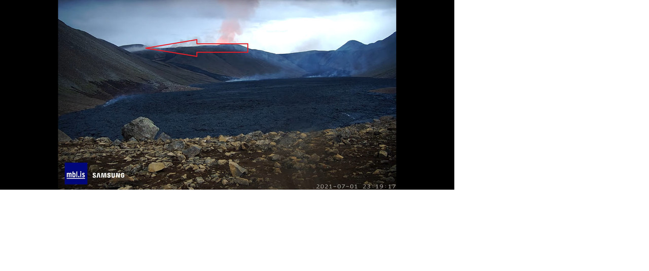
Has the wall been overcome?
It is almost scary seeing that white-yellow hot lava output from the elongated lava lake and possibly 2 vents geysering away. The lava is really flooding now and nothing is going to stop it from hitting the sea
If I recall correctly, the dams did smoke a lot – with ‘little’ to no damage. Can’t remember what East dam looked like at the breach time.
But good catch for the location of nearby lava heating things up! Might be a race to see which flow starts first.
Any idea about flow from over the saddle?
It may well be water steaming off the newer material. The lava may be flowing along that side of the gully.
Possibly. There’s a lot of steam / smoke coming from behind the hill.
Source: https://www.youtube.com/watch?v=XwN-u4Ccygs
OTH that smoke has gone for now.
NO expert, but am starting to think there is a new vent as Randall point out and others questioned.
Has the look of a fissure, doesn’t it.
Yes, indeed, at 11:56 pm, you can see lava bubbles pushed up simultaneously along a fissure. I wonder if the whole fissure just unzipped now?
Uh’Oh-‘Pu’u! Very Hawaiian looking. Jaggar’s got a picture in his book of Mokuaweoweo at Mauna Loa’s summit that looks just like that. Pu’u’O’o’ grew out of a vent like that as well.
Spot on ! Does look more like a fissure activity! Fog gone -show on!
It almost acts like the fissure conduit has unzipped into a rather long linear fissure and eruptive gases are pushing up from any location along this seam. It reminds me a bit of the original vents when they first started.
Seems like the splattering is getting more intense.
I wonder what the true rate of lava flow is now? I am going to guess about 30-40 m^3/sec now, much more than the usual quoted 13 m^3/sec. Maybe it is as high as 50m^3/sec ??
Seems a lot of flowing now!
https://www.youtube.com/watch?v=BA-9QzIcr3c shows people waiting for the torrent to flow down the valley.. huge amount of yellow hot lave running now, like a torrent
Too bad, it seems the RUV camera crew took a break….must be close to West Dam now.
🙁
Langihryggur webcam showing the lava is approaching the drop into Nátthagi over the western wall site.
And now they’ve gone and put it back on auto…..so there won’t be any record of what’s happening.
I had thought they were a news outfit?
Getting really close now.
The vent is really chucking lava out now. Low whistle and ‘wow’!
I get the impression the conduit is wide open, and goes into a long lull until pressure rebuild deep down.
Will the fissure unzipping be limited by the vent cone walls?
The morphology and topography of that entire vent area is likely to change rapidly.
Ok, can’t wait!Thanks!
And a flood of lava is about to go over the edge into Natthagi
Starting visible from natthagi Cam.
You can see the lava on the Natthagi cam now.
Lava going over the western wall:
Source: https://www.youtube.com/watch?v=BA-9QzIcr3c