In my previous article, here, I discussed how Kilauea and Mauna Loa volcanoes are connected to each other through the Pahala Swarm. Now I have to deal with a confrontation of theories that is inevitable. There is a classical model of how Hawaii works. It is all about the mantle plume. The classical view establishes that the different volcanoes have various magma chemistries which come from different parts of the plume, a mantle upwelling under Hawaii, and they follow vertical paths towards the individual volcanoes. Where is the problem? Mauna Loa and Kilauea have different chemistries. If they share the same magma source, which I’m quite convinced they do, then the classical model is wrong.
Nowadays no one dares go against the traditional view of how Hawaii works. But I will. I will explore the amazing possibilities that could come from a whole different way of thinking about Hawaiian volcanism. When all the magma comes from one.
The many paths of magma differentiation
As I pointed out in the preceding part of the this series, Kilauea has a highly variable magma supply. From 1840 to 1960 the supply was low. During this time certain elements, known as incompatible elements, increased their abundance in the magma. At the same time the Sr87/Sr86 isotopic ratio decreased, while the 206Pb/204Pb ratio increased. In other words the chemistry of the magma was shifting. During this time Mauna Loa was more active.
Something interesting happened in 1960. A large eruption took place in the East Rift Zone of Kilauea which used up so much magma that the summit nearly caldera-collapsed. This event produced an enormous amount of deflation. The next year a surge of magma came in which produced the highest levels of inflation ever recorded at Kilauea. The seismic pathways deep under the summit also reorganized. More east rift eruptions and intrusions followed in the next years. Ever since then, when not erupting, Kilauea inflates rapidly with magma. More so than in 1840-1950.

The summit of Kilauea starting to collapse in 1960. The not yet solid lava lake of 1952 is leaking into the collapsing crater. From USGS.
This seems to be a top-down process triggered by the 1960 eruption. What is interesting is that it affected the geochemistry enormously. All the trends drastically reversed. Since 1960 the incompatible element abundance of Kilauea has been decreasing while the Sr87/Sr86 ratio grows and the 206Pb/204Pb ratio falls. Or in other words, the volcanic processes affect the magma chemistry. Different chemistry thus doesn’t necessarily mean a different source but can also mean that the processes acting over the magma are not the same.
The incompatible elements are those that are left out from the crystallization process. Barium, Niobium or Lanthanum, for example, are some of the most incompatible. A magma that has undergone more crystallization is expected to be more enriched in them. They become concentrated in the remaining liquid. Here mushes might be important. Magma sponge? The rift zones are thought to be filled with these mushes. Because the rifts are continuously spreading enormous amounts of material go into them that never reach the surface. Excess incompatible elements might be expelled into the conduits or magma chambers during these processes. If magma has to reach Kilauea from Pahala through the southwest rift, then what happens to this magma as it moves underground through the rift zone? This is poorly understood. If anything is clear though it is that the faster the magma moves towards the surface the less enriched it would be. Slower would be more enriched in incompatible elements. What happened 1960 was a change in how fast magma rose into Kilauea, a transition from low to high supply, so that was possibly the reason for all the chemical changes it triggered.
Instead I don’t know much about the properties of the Sr87/Sr86 and 206Pb/204Pb ratios. How or why, or when they would change, I don’t know. I will have to explore this issue in the future. The events of 1960 do suggest however that they can also be altered by volcanic processes. Each Hawaiian volcano usually has particular isotopic ratios that distinguish them from each other. Mauna Loa and Kilauea have their own distinct ratios. This is usually assumed to mean that the magma source is different. I however would consider that like in 1960 there must be volcanic phenomena that alter these characteristics, and that it would rather be a difference in the way magma is transported towards the surface.
The one magma
Another type of geochemical variability that exists in Hawaii is the alkalinity. This refers to the amount of NaO2+K2O in the magma. Volcanic rocks are classified into different types depending on the alkalinity. The kinds of rock that Hawaiian central volcanoes commonly erupt are, in increasing order of alkalinity, increasing order of NaO2+K2O: tholeiite basalts, transitional basalts, alkali basalts and basanites.

Types of volcanic rocks depending on silica and alkali content. From Wikimedia by Woudloper.
As usual this is explained by these types originating from different parts of the mantle plume, with the central part generating the tholeiites, and the edges making the more alkaline types. Problem is that Mauna Loa and Kilauea have slightly different levels of alkalinity. And also I will be soon saying that Hualalai is connected to them, and Hualalai erupts transitional basalt. So I prefer alternate models.
All the types of magma erupted in the Hawaii Island could be obtained from an homogeneous melt similar to Mid-Ocean Ridge Basalts. It just depends on the minerals.
Hawaiian magma first crystallizes the mineral chromite, but it does so in insignificant amounts, second comes olivine, which is more important, then clinopyroxene, and then plagioclase, also important. The order has to do with the temperature. Olivine has about 40% silica, while clinopyroxene and plagioclase have around 52-53%. The parental magma is somewhere in between, around 47 % silica. This is a crossroad. If the magma crystallizes mostly olivine then it will increase in silica rapidly. If it crystallizes mostly clinopyroxene or plagioclase it will actually decrease in silica and move towards more alkaline compositions. Temperature could have a lot to do in shifting the process to one side or the other. Higher temperature would favour olivine. Depending on the amount of minerals of one type or the other that it forms, then it would result in a very wide range of alkalinity.
From this point of view the tholeiitic lavas erupted by Kilauea and Mauna Loa are tholeiite basalts that are almost unchanged from the original melt and have underwent only small amounts of olivine crystallization. The alkaline lavas of the older volcanoes would be more evolved and generated through a more clinopyroxene and plagioclase dominated fractionation. This also seems to be supported by how the amount of incompatible elements seems to be directly proportional to the level of alkalinity. The most ultramafic and alkaline magmas always are the most enriched. Presumably meaning they have underwent more crystallization.
The high concentration of incompatible elements in the basanites that Haleakala currently erupts suggest that about 75 % of the original magma could have crystallized, 25 % reaches the surface. The even higher enrichment of ultramafic nephelinites from the volcanic fields of Oahu would suggest that barely 3-7 % of the original magma has survived the journey there. Alkaline magmas also tend to concentrate water. I don’t if this is true for CO2 too.

Volcanic field eruptions of Oahu. Ultramafic nephelinite is frequent here. From Wikimedia by Mbz1.
To me it makes a lot of sense that some hawaiian volcanoes would carry melt more efficiently than other. For example Mauna Loa and Kilauea have mature plumbings, with central conduits, and magma chambers, and will carry the melt much more efficiently towards the surface than the mushy volcanic fields of Oahu. This should be reflected somehow in the chemistry. I think that alkalinity is the way this is reflected. In this theory not the source but rather the volcanic structures and processes would produce the different chemistries.
Both Kilauea and Mauna Loa are also known to have produced rare eruptions of alkali basalts from their flanks. This could happen when the magma bypasses the summit plumbing and instead rises through the rifts, which Loihi seems to demonstrate quite well, by erupting tholeiitic basalts from the summit, and both tholeiitic and alkali from the flanks. This I think argues against the classic mantle plume model for the magma generation. Instead it is more consistent with the different pathways taken.
Magma rhizomes
If Kilauea volcano feeds laterally from Pahala, 40 kilometres away, then it is also likely that other older Hawaiian volcanoes did the same. I have investigated this question and reached some interesting theories. The theory I’m going to show here might seem unnecessarily complicated, but it is the best way I know of explaining the different types of volcanoes in Hawaii, their timing, the relationship to each other and how the Mauna Loa-Pahala-Kilauea connection works. It explains A LOT.
A lot of insight came from comparing Kilauea to Piton de la Fournaise, a volcano near Madagascar. These two volcanoes are often considered as analogues to each other. There is one structure that I find particularly interesting. The northeast rift zone. This NE rift connects the two volcanoes of the island, the older Piton des Neiges to the northwest, and the younger Piton de la Fournaise to the southeast. The rift erupts lavas more alkaline than those of Piton de la Fournaise, meaning that it could be a deep structure that bypasses the summit. Earthquakes under the rift run at a depth of 20 kilometres, and marks a path leading to below the flank of Piton des Neiges edifice, here it descends to a depth of 30 kilometres, and when also considering that a lot of CO2 has been observed to be emitted by this rift, it does seem likely it represents the feeder path of Piton de la Fournaise. Does the younger volcano feed from the older one?

The two volcanoes of Reunion are connected by the NE rift of Piton de la Fournaise, Deep earthquake activity and gas emissions show that the NE rift is a magma pathway probably carrying malt towards Piton de La Fournaise. Created in Google Earth.
I imagine the rift zones as being similar to the rhizomes of plants, and the volcanoes being stems, a volcano can grow a rift laterally and then a second volcano might sprout from this rift system. So then what if some volcanoes can act as feeders to other volcanoes? What if this happens in Hawaii? It turns out this could provide the answer to many questions about Hawaiian volcanism that I had.
Volcanic Complexes
The construction of Hawaiian volcanoes doesn’t follow a perfect progression. One would expect that as the Pacific Plate moves over the Hawaii Hotspot it would make one volcano, then another, and another, and so on. But no. Actually it is more sequential, with one group of volcanoes growing during a certain period and then activity moving to the next group. I will call these volcanic complexes. I will call each complex after the volcano that I think was the first in each of them.
This is the timing of the main tholeiitic stage of each Hawaiian volcano of the past ~6 million years:
Loihi: Entering tholeiitic stage. New complex?
Hualalai Complex:
- Kilauea: 0.1 Ma-present.
- Mauna Loa: 0.47 Ma-present
- Hualalai: ?-0.1 Ma.
Mahukona Complex:
- Mauna Kea: ~0.7-0.4 Ma
- Kohala: 1.1-~0.5 Ma.
- Mahukona: ?-0.6 Ma
Lanai Complex:
- Haleakala: 1.9-1.25 Ma
- West Maui: 1.8-1.4 Ma
- Kahoolawe ?-~1.15 Ma
- Lanai: ?-1.3 Ma
Koolau Complex:
- East Molokai: Somewhere before 1.75 Ma
- West Molokai: ?-1.9 Ma
- Koolau: 3.2-1.8 Ma
Kaena Complex
- Waianae: 3.9-3.3 Ma
- W and E Kaena: ?-3.6 Ma
Lihue Complex:
- Kauai: 5.4-3.9 Ma
- Niihau: 5.5-4.7 Ma
- Kaula: ?
There are other reasons to think each of these groups are separate structures. The Lihue Complex forms a topographic seamount that is separated from the other volcanoes of Hawaii. There was a large shield volcano located in what is now the western side of Kauai Island, this was the Waimea shield. It is thought to have had a giant caldera 20 km across. The island of Niihau are the remnants of the Waimea’s rift zone. The rift runs in an east-west direction connecting the three volcanoes of the complex, with Waimea in the centre, linking to the Lihue shield volcano on the eastern side of Kauai, and to the Kaula volcano in the west. All part of one large structure.

Lihue volcano complex. Niihau is the rift zone of Waimea Shield Volcano, partly destroyed by landslides. From USGS.
Complexes usually share the same shoreline break, except the Mahukona Complex. What is a shoreline break? The enormous weight of Hawaiian volcanoes pushes them down into the Earth. As they are active they grow and make an island that keeps getting bigger, but afterwards they start waning and the island sinks into the ocean. The shoreline break is the ancient submerged coastline that marks where the edge of the island once stood. Each group seems to have roughly the same shoreline break which basically means that they rose and fell together.

The main shoreline breaks are shown in colours, they mark the size of the islands at their greatest extension. Each shoreline break seems linked to a particular complex. The volcanoes are represented as circles.
This is particularly impressive for the Lanai Complex. These four volcanoes grew to form the largest Hawaiian Island, of all times? It is called Maui Nui, meaning Great Maui. They were also joined to the emerged remnants of the Molokai volcanoes. At the time it was even bigger than the island that Pūhāhonu, the so called “Earth’s Biggest and Hottest Shield Volcano” created when it was erupting 13 million years ago. After Maui Nui became inactive it sank 2 kilometres into the crust, so that the saddles between the mountains were inundated, and the ancient landmass “broke” into the four islands of Molokai, Lanai, Kahoolawe and Maui.
Multiple volcanoes of each group often share landslide fans. For example the eastern side of the three Koolau Complex volcanoes collapsed in the Nuuanu-Wailau landslide complex, that with a volume of ~7000 km3 is among the largest on Earth. This makes sense, if the volcanoes grow together they should also reach gravitational instability together.

Nuuanu-Wailau landslide complex. From USGS.
So why the complexes? I speculate that each of these could be sharing the same magma feeder. Each group of 3-4 volcanoes would feed from one specific spot that was originally melted by the hotspot. Magma would travel sideways using the rifts. I have confirmed that the rift orientations of the volcanoes in each complex could potentially intersect with each other providing a network of magma passages between the various volcanoes of the complex. I will look more into this aspect in the next post where I will explain how the ancient rift of Mauna Loa, the Ninole Hills Rift connects with Pahala, which in turn connects to Kilauea through the Southwest Rift. Pahala being a junction in the rift network.

Each complex of volcanoes and its rift zones. Created in Google Earth.
I should also mention that there is a large active volcanic area that covers the northern islands, and an additional extension of the abyssal plains to the north. The North Hawaiian Arch Volcanic Field, it is among the few largest volcanic fields of the world. Some of its submarine eruptions are estimated at 40-70 km3. It generally erupts basanites or nephelinites. I don’t think it was created by the hotspot, while its exact age is not known it was already active when the Koolau volcano complex grew, because the debris of the landslides covers some of the lava flows. It still remains active, so it is fixed to the plate and not the mantle, and much of it is significantly off-track from the hotspot too.
One theory is that it is produced by flexure of the lithosphere around the load of the islands, so that it is pushed up and and undergoes decompression melting. I find the decompression effect very small though, about 1 km of uplift which is not much. In comparison lithospheric extension can cause the mantle to rise in the order of tens of kilometres. The eruptions also sometimes happen within areas that have actually subsided, like Kauai or Oahu.
So I find it most likely to be a tectonic feature. Volcanism strengthened enormously from Lihue to Lanai volcanoes, as the hotspot and the volcanic field met. So there may have been some tectonic-hotspot interaction in the recent pulse of volcanic activity of Hawaii.
Cyclic volcanoes
The idea that multiple volcanoes feed from the same magma feeder also provides an explanation to the different types of volcanoes that exist in Hawaii. Central volcanoes come in 2 types.
Most are covered entirely in tholeiitic basalts, or tholeiitic plus transitional, with only sometimes minuscule amounts of alkaline lavas, and they have low slopes.
Some have instead erupted large volumes of viscous alkalic lavas sometimes completely mantling the tholeiite lavas in all subaerial exposures, this gives them a more stratovolcano-like shape. It turns out that there is one stratovolcanish system in each the Mahukona, Lanai, Koolau and Kaena complexes. These are Mauna Kea, Haleakala, East Molokai and Waianae volcanoes. These four have erupted the vast majority of the alkaline lavas among the central volcanoes of Hawaii. They are the highest and steepest and must have at some point towered proudly above all others, majestically like Mauna Kea, the white mountain, does today:

Topographic shape of each complex. They are not to scale respect to each other but rather are intended to show the similarities in slope steepness patterns and relative heights of the volcanoes within each complex compared to the others.
The Lihue complex also has its own alkalic volcano, Kaula, which erupted phonolites, some of the most alkaline and silicic lavas of Hawaii. Kaula is very small though compared to its younger counterparts. Still, each complex has one.
In the Hualalai complex there are also some differences in the alkalinity. The most surprising is that while Kilauea is the more active, more powerful volcano, its lavas are actually slightly more alkaline than those of Mauna Loa. Alkalinity is related to the waning of the volcanic system and also as I’ve argued probably to lower temperatures and clinopyroxene/plagioclase crystallization. Why does the more active volcano erupt more alkaline lavas? There is also a difference in the amount of incompatible elements, which are higher in Kilauea. If the magma moves laterally, like from Pahala, and beyond, it might lose some of its heat, or crystallize more, interact with the rift, and make the magmas more incompatible element enriched, and more alkaline.
These gradients are roughly seen in all the complexes. In the Lanai complex, one end erupted the strongest tholeiitic lavas of Hawaii, the basalts of Lanai. The opposite end is truly the inverse with the most alkaline lavas of all Hawaiian central volcanoes, the basanites of Haleakala. Even in its peak tholeiitic stage Haleakala had twice as much incompatible element contents of Barium and Niobium compared to Lanai. As I will show these gradients also show in the isotope ratios erupted by each volcano.

Mauna Kea. A final volcano type. From Wikimedia by Nula666.
My theory is the following. The hotspot melts an initial volcano, like Lanai. The initial volcano develops a rift system which branches and propagates, the volcanic activity migrates with the propagating rift so that new volcanoes are created. Haleakala is an example of a final volcano, the one which is situated in the propagating end of the rift. When the next complex arises, the previous complex wanes. The waning complex will become increasingly alkalic due to the death and freezing of the plumbing system. These alkalic magmas will be provided mostly to the volcano at the propagating side of the rift system, the final volcano, like Haleakala, will erupt most alkaline lavas. If this is true then the volcano progression would be something like this:
Lihue>Waimea>Kaula
W Kaena>E Kaena>Waianae
Koolau>W Molokai>E Molokai
Lanai>Kahoolawe>W Maui>Haleakala
Mahukona>Kohala>Mauna Kea
Hualalai>Mauna Loa>Kilauea
Magma would be transported from the initial volcano to the final creating a gradient in the chemical composition.

The complexes compared to the inferred rift propagation and hotspot track. Created in Google Earth.
This could explain some interesting landforms of Hawaii. Particularly the Hawaiian Moat. The moat or through is a depressed area of the ocean floor that is located on the eastern side of Hawaii. But why the eastern? This is might seem like a silly detail, however this detail had me quite intrigued for some time. The last 5 complexes have all grown eastward/southeastward, perhaps because they influence each other to follow similar directions. If the edifices of each complex build on top of each other then a lot more piled-up weight will end up on the eastern side, thus depressing mostly that part.

From USGS.
There are 4 prominent rift zones that emerge eastwards from the moat side of the islands. The Pauwela Ridge, the Hana Ridge, the Hilo Ridge and the Puna Ridge. Each emerges from one of the last 4 complexes. I think that these rifts are the propagating tips of the branching rift systems of each complexes, they are seen best where they erupt underwater and make steep ridges.
The isotopic ratios
Lastly there is one other geochemical characteristic of the magmas that could be related to the complexes. Hawaiian volcanoes show different isotopic ratios. When the volcanoes are plotted one complex after another and in the order in which the complex seems to have grown, in which the rift has propagated, there are some interesting gradients that show up. It seems to me that as magma is transported laterally it might be affecting the isotopic ratios too and causing their variation among Hawaiian volcanoes. I don’t know however which mechanisms could be affecting them.

Ranges of 87Sr/86Sr isotope ratios in the volcanoes of Hawaii.

206Pb/204Pb isotopic ratio ranges in the volcanoes of Hawaii.
In the next part I will be looking at how rift zones work and how Kilauea was born.


.jpg#/media/File:Mauna_Kea_from_Mauna_Loa_Observatory,_Hawaii_-_20100913.jpg)
3 hours 19. Not bad…it ended up with a big gushing, so we’ll see how long to “recharge”.
All that lava in Geldingadlir….hope that dam holds well!
That break didn’t last.

3 pulses till now, very different each other. That was heavy.
I saw on the news that the volcano might be taking a break and took a few hours off myself.
But as soon as I checked back in it was apparent that it had gone into 5th gear with the addition of the new vent and as per usual my VC friends had spotted it first.
(And a great new post from Hèctor)
I stopped trying to get ahead of these guys. Not gonna happen.
Now we’re back to pulsing again at 1:16 am in the morning. The FAF highpass seismic trace is interesting to look at and to try to correlate what is happening with the cone.
I love the colors right as a surge hits its peak. The electric pink!
I see what you mean, it’s awesome the colours! Under lockdown-so I appreciate the light and lava show!
The latest “lava flood” is finally ebbing after at least an hour of intense flowrates. May be the most total flow in a single eruption I’ve seen so far.
Given the length of time the near constant uber-flow rates lasted, and that the flows were likely higher than the dyke can efficiently transport at any given moment, I’m starting to thing there must be a shallow magma chamber evolving below. It would make sense, since the eruptive cycle is currently one of prolonged periods (relatively speaking) of quiescence followed by a prolonged purge of lava…kinda like a balloon filling up then popping a hole. So, somewhere there must be a “balloon”.
That cat under Iceland. Andrew Roberts was right. It sleeps all day then gets the Zoomies at night.
I see what you mean, it’s awesome the colours! Under lockdown-so I appreciate the light and lava show!
I double up oops!
I have been watching the FAF highpass for a few days now, and there seems to be a somewhat predictable pattern. When the linear trace line becomes wide enough due to gas activity, then the trace switches over to pulsing. After a series of pulses, then the trace quiets down.. as we have seen yesterday. And then slowly the line begins to broaden, then finally a new series of pulsations hit.
In some of these pulses tonight, a huge amount of lava was gushed suddenly over the cone walls.
The 02:10 gush is pretty spectacular.
That’s the sort that build the elevation of the cone and its surrounding 300 meters or so. It overflows over a wide area so more of the lava solidifies, as opposed to being carried away by a stream. After the surge the whole cone is glowing static. Or I should say it would build elevation if it keeps doing that. This volcano keeps doing something different every few hours. Wouldn’t shock me if it started belching out wildflowers for a bit.
This blog in a nutshell
It’s such a show off though. Knows how to keep us interested.
Which volcano is that? Mt Rainier in WA ? (smile). The huge amount of SO2 wafted from Taal is a signal that something major is about to happen. We get it.
Is there any live video of this danger? maybe 5 hd cams?
Eruption has stopped once again. No more lava activity in over an hour and tremor dropped significantly.
If you check back the past 3 weeks on this plot (http://) hraun.vedur.is/ja/drumplot/drumplot/faf_highpass_2.0.png it seems to have a reoccurring pattern. The activity slowly builds up, then switches to pulsing mode, then runs out of steam. I think we’re looking at a large geyser structure except the magma is having to accumulate a head of gas pressure to exit.
Something’s got in its throat. It vented a cloud of dark particulate matter. Now quiet. Small amount of white outgassing.
Saw that. First time I’ve seen it rolling coal like that. Really dark clouds.
At 3:42am, the cone belched a very, very dark cloud that appears to be ash?
It lasted for 4-5 minutes.
At 4:15 a.m. heavy dark particulate cloud. Suspect that a wall may be collapsing into the vent and being ejected as particulate..
from 4:04am to 4:16am bits and pieces of the cone seem to be falling in, with a big chunk causing another dark cloud right at 4:15am.
Looks like the eruption is changing again. Instead of geysering it seems to be doing discrete episodes. This is a lot like Pu’u O’o, which did eruptions like this only once a month, erupting about 10-20 million m3 of lava per sitting towards then end. Volumetrically small but extremely intense, if this is what is going to happen here now, where it has a few days of rest before erupting, that is the sort of thing that will reach the ocean.
I do wonder though, the last episode seems to have seen the lava actually withdraw from the crater, with the vent being plugged by rubble which is why there was some ash. If/when the lava returns it could rupture the rift and open up a curtain of fire along the fissure line, or even extend it further. That did also happen at Pu’u O’o a few times in the 1980s, including its final failure in 1986. Etna also has done this many times with similar results.
Good call, makes sense – esp with puffs of smoke at times arise.
Early morning here sleepy. I am in to your thinking chad. Did not see you write more or less what i was thinking 🙂 . see now if the pressure go up. And if the rift crack or if it push up at vent again
If I remember right, the high fountain episodes of Pu’u’o’o and Mauna Ulu usually ended with black clouds of smoke coming out of the vent as the magma column dropped. So we are probably seeing a similar thing going on.
The big difference between the two situations is that Pu’u’o’o had a large magma chamber, the magma chamber of Kilauea feeding it, so that it built up pressure and then released it with each high fountain event, which is why the episodes were so big. Fagradalsfjall doesn’t have a large magma chamber so it will probably play out differently, even if there are some resemblances too.
Yes, but if this lasts a long time it could start to create a shallow magma chamber, not multiple km3 but something big enough to moderate fountaining episodes days or even weeks apart.
As I say this there is another long a’a flow that is already in natthagi, it looks like the episodes are getting bigger overall as the flows never used to go so far early on even with high effusion. I do wonder whether there is some amount of magma accumulation at the deep source, because as Carl has pointed out the eruption rate is too high for decompression melt alone, right now anyway.
After the great over flow event earlier on, now it’s goon weird-the silence/pause is a new behaviour one needs to adapt to.I presume the volcano entered a new phased. Perhaps curtins of fire and ash or long silent pauses I enjoyed today’s show!
‘gone weird ‘
Little strange behavior. Look at close up camera time for the smokie part. And dont look like a massive wall fall.. wonder if the lava pond drained out fast. Just thinking out loud 🙂
Hector, how does the refilling rate after 2018 compare to after 1960?
I watched the by now famous timelapse of the caldera collapse in 2018, it occurred to me that the outer downdropped block, and fully half of the total collapse volume if not more, only started to fall in July. On the GPS you can actually see where the collapse seems to have briefly slowed or stopped before it falls again. The GPS data on the main page of course records the cross caldera distance not vertical, so piston caldera collapse will not show up at all. Thing is while it looks like the recovery up to present is small it is actually recovered past this bump which would imply in only 3 years more than half the volume lost from the summit in 2018 has been recovered, and this would possibly not include anything going into the rifts, which seem already to have recovered years ago.
I am probably missing some information, but it seems to me that there is currently a great surge of decompression melting, on the order of 0.3 km3 a year or more.
Recently too there has been a lot of south flank quakes showing spreading, even down as far as Leilani, and at the same time the summit inflation has ceased. It looks like rifting is still ongoing just invisible to the eye, your theory on further significant ERZ activity looks quite likely.
I have been wondering about that question too. The resupply after 1960 arrived quickly and was very intense, when the magma surge arrived, about 10 months after the eruption start, the inflation of the summit was multiple times faster than we have seen after the 2018 eruption so far, and it kept at higher levels than has been seen ever since, until the East Rift eruption of the following year.
Up until 1960 the magma pathways that were being used were different. The tremor and deep earthquakes happened right under Kilauea and to the north of it. The resupply to the 1960 eruption must have come from somewhere much closer, under Kilauea itself probably. This area may have been exhausted perhaps, so Kilauea had to look somewhere farther away in 2018.
I recall that in 1924 the deflation was detected in Keeau, that is a long way from the summit. I wonder if the resupply in 1961 was the final surge of that source, as you say that could have been depleted by now.
I guess that does mean the volcanoes dont entirely feed on each other though, there is local magma feed, but if Mauna Loa and Kilauea are satellites of Hualalai that is pretty profound. Hualalai is very big, just subsided, and Kilauea is probably going to be the biggest of the bunch, so combining them to one is going to give a volcano for the record books, getting on 150,000 km3, same as Puhahonu. Might not get as big as Maui Nui but close. Loihi will very probably join to Kilauea if it grows to a large size, so a future ‘Hawaii Nui’ is on the cards 🙂
Today is my second full day ain Grindavik, on the first evening it was all rain and fog, yesterday during the day. I went to Storihrutur, and while it is not too much of a hike, it took me 12hrs, as I spent a lot of time talking to stranger, barbecuing Marshmallows and Sausages, photographing flowers, flying drones, staring at the volcano.
From Storihrutur gushing Lava could be seen from time to time. With the Drone the Lava pond and a Lava fall into a tube? was spectacular to see. I will not go around Meradalir, as it looks boring, and there is so much more to see. Today I will go up Path B. Can anyone give me the GPS coordinates of the original Webcam looking into Geldingadalir? Maybe I walk there, or maybe I just fly the Drone there. I will upload a few unedited low res images later.
When I saw the ash on the tent and car this morning, as I haven’t heard about ash from this eruption, but now I know it to be correct.
My email is philiplsalzgeber.at
Phil
Quick eyeballing of the location of the webcam, so not super precise, but the camera should be possible to locate when on location.
I’ve just seen similar on the closeup webcam, look at 3.42. It looks like ash to me.
Here is the link to the album:
https://1drv.ms/a/s!AjfGuqxEeYDx9GFupI9p7dLwzyTz
One more coffee an topping of the batteries.
My attempt to make my e-mail address bot safe garbled it, here I try again:
philipp*you-know-whAT-goes-here*Salzgeber.at
cheers,
phil
On the contrary, give us a little warning, stand in front of the camera and wave at us. 😀
Enjoy! I’m envious.
Remember not to stand right in front of the camera with your posterior close to the lens!! 😀
Very grateful for the link to the album. Fantastic photos! Thanks!
Thank you!
First episode of some sort of collapse is at 02.22am. Initiates at right, and seems to propagate towards the centre. My impression is that it’s the front internal wall/overhang; possibly due to lava withdrawal after that last huge belch?
More at 2.34, 3.14, 3.18, grumbling it’s way along to 3.27, 3.36, winding up to the biggie at 3.42.
Can a dragon take a look at the 3.42 event? Lots of black, not brown stuff belching out in a huge column. It looks more than just a wall collapse.
More ash(?) at 3.45, then a proper back-wall collapse at 3.49.
3.53, oh and it carries on every few minutes up to the biggie at 4.15.
This is more than just updraughting dust, surely?
There were three ash producing episodes: 3:42, 3:49 and 4:15. This was after the main eruption had ended. The seismographs had changed from active to pulsing to quiet. Around this time there were a few more weak pulses. The 3:42 event is notable on the seismographs with a drawn-out signal typical of a collapse. I think a fairly significant part of the cone went down. It closed off the lid but the fresh lava still had some gas left. So it triggered an explosion. The gas build up below the blockage twice more before the gas had all been expelled. The most likely cause of the collapse is the fresh veneer put on the surface of the cone by the spattering.
It seems to be that the visir camera shows a wall in front of the cone which I don’t remember from before.
The wall’s been building for a week (I mentioned visir camera needed moving up the hill), I think these last huge outflows just got it up to top of cone level or very near.
So your verdict on the smoke/ash is collapsing inner walls (and presumably a lower lava lake) rather than a change in the general character of the eruption?
Yep
The seismograph showed another collapse feature at 10:53 this morning. The camera showed that it happened at the back of the cone. It was mostly hidden behind the dust but you can see the wall opening up
I commented earlier that volcanic edifices are nothing but piles of junk just waiting to be collapsed by forces in excess of their resistance. This young lava is no better and the phenomenon is likely quite common in the building process. The difference here is that the whole world is watching every move. What miffs me is the disappointment expressed by many that their clean and neat celebratory holiday ‘fireworks’ display has resolved into the dirty business which volcanism is famous for. When the silica begins to infiltrate their persons and their property, these ‘volcano tourists’ may ultimately decide that the juice was just not worth the squeeze.
An aerial view of that vent would be informative. Right now, the way the condensate is rising, it appears that there’s a block of debris sitting on its edge in the throat of the cone, an the gases are rising off that and cooling.
Anyone know how high the eruption column actually got? Can’t find a VAA for it.
It wasn’t VAA height.. it went to a few hundred meters. These were not major ash clouds. It is however possible that the next eruption phase will have to break through a bigger layer of tuff and could start with a bigger explosion. Guessing, but when seismic activity increases again it might be an idea not to be on theatre hill.
Not an official position of VolcanoCafe… but it could be bad.
Opinion only.
(Not Icelandic)
A more evolved magma getting in on the act?
And Gutn Tog was there filming during the night:
https://youtu.be/aBzTUcuvYL8
A comment on the post: The idea of rift propagation is a powerful one. The change in isotopic ratios is perhaps most easily explained through melting of oceanic crust into the magma. Within each complex, the volcanoes are a fixed distance from each other. The depth of the magma that feeds them should be comparable to this distance, or 20-40 km which is a bit deep for oceanic crust. So within the oceanic crust the different volcanoes have different interactions with the crust, along the lines that you say.
The different complexes are much further apart, and that suggest they branch at a much greater depth. So you get a model where the plume stalls at a depth of 100-200 km which is also where the melt begins. The melt rises through a weakness and develops into magma reserves at ~ 30 km which form each volcano in turn. I can buy the importance of the rifts in this, forming longer-distance pathways to shallower reservoirs and connecting the volcanoes at depth. Over time the complex grows and grows and depresses the crust below. This stops the melt and cuts off its supply. A new deep melt reservoir will now form further on where the crust and mantle remain uncompressed.
For some reason the western volcanoes form earlier than the eastern volcanoes. This also causes the rifts to primarily develop towards the east: the rifts form on the slopes of the main volcanoes (along lines of constant height) and when the western volcano develops (e.g. Mauna Loa), that slope is governed by the biggest volcano behind it which is the previous eastern one (c.f. Mauna Kea). The next eastern volcano (Kilauea) grows on this rift. A possible cause of this asymmetry could be a slight incline of the plume.
Pahala? I don’t think it is the plume conduit. I think it is magma rising to Mauna Loa, of which a fraction is deflected south by the pressure of its weight. Pahala is exactly where you would expect a new volcano to develop (it is a gap in the regular distances between peak) but that does not seem to be happening. Instead it is feeding into the rift on which Kilauea is located, although it is I think not the only magma source for Kilauea.
Great post
And if the lack of lava causes withdrawal symptoms, I can recommend this for visual stimulus
https://www.bbc.co.uk/news/in-pictures-57653901
How much of the valley is now filled in with lava? Is it a proper shield yet?
https://www.facebook.com/282188751812730/posts/4443888005642763/?sfnsn=scwshmo
Posted over an hour ago.
Are we about to play a new round of ‘cherchez le lave’?
I wonder if that was taken from the helicopter I saw a couple of hours ago?
Certainly looks totally empty, which didn’t seem to be the case in its previous quiet spells. Tremor is low too. But this volcano has surprised me before, Vulcan may be taking the weekend off to watch Wimbledon and Italy in the Euro quarter finals.
Interior is very red-coloured – how much iron is in that lava?
Would be very iron rich I think, beingMORB basalt with some plume signature. I dont think it will stay an empty crater for long though, not unless the deep source has died off.
By iron rich – what percentage are we talking – worth using as ore?
“Holy ‘so let it be written so let it be done’, Batman!” It will be interesting to see the events which will ensue when that throat is cleared.
My thoughts exactly (minus the Batman part). It will be interesting to see what happens if (and that’s a big if) it gets going again without a lot of lava muffling the action. High fountains maybe?
Etna mode, or Mauna Loa mode, one of those two… 🙂
“They think it is all over. Well, it is now.” To quote the 1966 World Cup for England.
Is the party over? It is beginning to look like it. That crater looks finished.
A timelapse from last night from the RUV langihryggur camera, I had to cut out a lot though unfortunately. (people)
https://youtu.be/H5C_ozkdLj8
Interesting now see what going to be of this.. A bigger poff to clear the pipe or if this redraw of lava also make conduit to collaps. Have this change anything on seismographs for other arias ? If there is any power left it should be seen soon.. When waiting maybe i look after my vegs in the garden and miss everything probleby.. 🙂 Have a nice weekend out there.
I’m guessing it’ll clear its throat on the 7th to 9th of July. That’s from looking at the tremor plots, which might just as well indicate it’s down for good.
Nope. No more predictions for this cowboy. This volcano makes fools of people infinitely better informed than I am. It’s like it’s laughing at us.
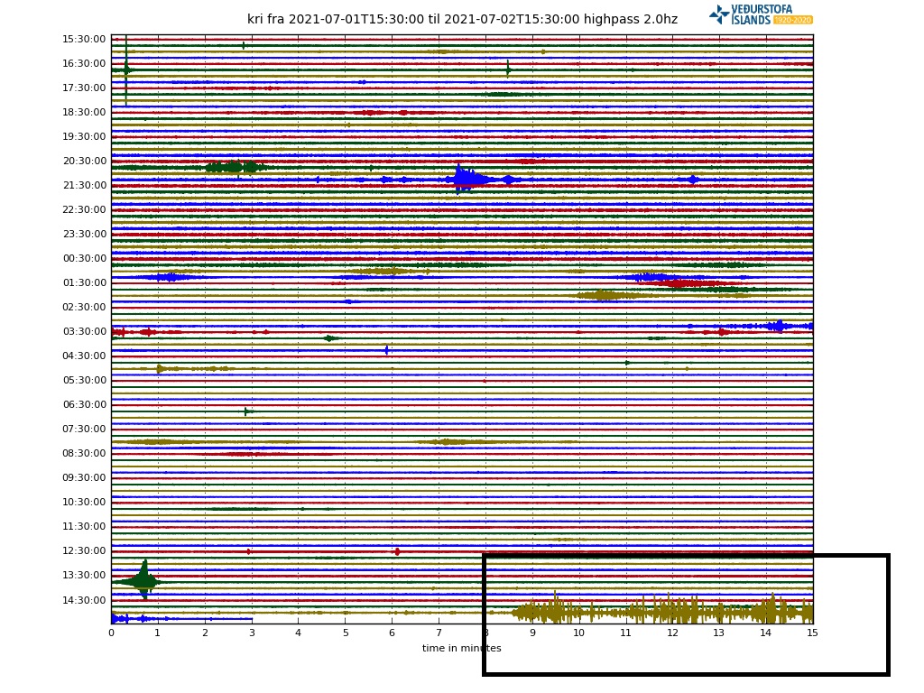
The Krisuvik drumplot is doing that weird thing again. It looks like a period of crackling rock as if it is being pulled apart.
Here’s the picture:
The low pass looks a bit funky too with 2 minute interval bounce.
Man made?
More pictures showing the ‘empty’ crater.
https://www.mbl.is/frettir/innlent/2021/07/02/ekkert_raudgloandi_hraun_gosid_mogulega_buid/
…and it’s back: https://www.mbl.is/frettir/innlent/2021/07/02/hraun_rennur_a_ny_i_geldingadolum/
I see gradually increasing tremor on faf, with occasional small quakes and other disturbances. As before, this is a temporary lull and will soon end.
But why are these “deep lulls” occurring now, that did not occur before?
Tremor increasing on faf, smoke increasing in crater, BUT
OK, the x-axis of the tremor plots is time, and the colours represent frequency, but what’s the y-axis, which is labelled from 8000 through 0 to -1000? What are the units?
Is it amplitude? But you can’t have -ve amplitude surely?
Are the Visir and Langihryggur webcams broken? V is stuck at 16.23.33, and L is black screen.
And the mbl.is closeup camera is cycling about 14.45.38 with the circle of doom…
For the attention of Icelandic Volcano Webcam operators, future eruptions.
When establishing cameras, please observe these rules:
1. Find a location around half a kilometre from any known or likely footpath.
2. Establish base unit, and mount camera with loudspeaker on 6 meter pole. Bolt firmly.
3. Test and final positioning.
4. Unroll 8 meters of brand new razor wire (coiled) and spread around base unit.
5. Mount high-power sniper rifle 0.5 km uphill from site. Leave assassin (contract) in place. Supply with food and Portaloo.
6. Switch on camera and equipment.
7. Supply monitoring and IT staff with copious amounts of coffee.
I know this makes me look bad, but I have never wished death on so many people as I have during this eruption. I like your ideas. but I was thinking of making a game of it: leave the camera position the same, but add a viewer-controlled poison dart gun. The viewer with the most ‘kills’ wins a free trip to the volcano. You’d probably also want a poking stick to shove the bodies down the hill so they don’t pile up in front of the camera. Obviously, there are logistical issues, but I think it could work.
Lot’s of mamatic movement showing up on the FAL/FRA webicorder in the last couple of hours…which I think Twisted One is referring to. No signs of eruption at the volcano, though. Earlier I made a comment of a small magma chamber that may recharging and draining to explain the huge lava discharge during each eruptive episode…and IMHO the tremor suggests this is what may be happening….the magma chamber is recharging.
If so, then I agree that a new and voluminous eruption may be in the offing.
It’s boiling again.
Great, what would I have looked at at my second screen otherwise?
I hope it goes on for a long time so I can plan a vacation there…
Yesterday I was wondering what was doing the spattering on the right side of the volcano as seen from the close up camera.. Thankfully this video shows that one clearly (at the bottom middle in the screen-cap, 50seconds into the video), it being a vent just at the entry to a lava tube going down (probably towards meradalir) also explains the smoke seen at the bottom of that side of the crater. I do recommend watching the video too as it really makes it apparent how the lava is going down that tube..
https://imgur.com/a/yDwvGTR
https://www.youtube.com/watch?v=eBI7HhV_b_o
All credits of course goes to Ian in London on youtube
Lots of fountaining and splattering on the RUV cam.
It’s back! For a bit, anyway.
The Icelandic Tourist Board, Visit Reykjanes, Reykjavik Excursions all breathe a sigh of relief.
Can anyone answer my question about the tremor plots
OK, the x-axis of the tremor plots is time, and the colours represent different frequencies, but what’s the y-axis, which is labelled from 8000 through 0 to -1000? What are the units?
Is it amplitude? But you can’t have -ve amplitude surely?
I suppose it could be amplitude relative to a baseline level or it could just be an automatic scale, which from experience, Excel has a habit of doing just when you don’t want it to.
Quote from IMO:
“The graphs show average vertical movement per minute for each seismometer, in three frequency ranges (Hz).The vertical axis has the same scale for each station. The main purpose of these graphs is to monitor changes in intensity of seismic wave motion. The absolute value of the scale has no meaning. ”
Source”. http://hraun.vedur.is/ja/englishweb/tremor.html
I note that the activity has been most prominent in the forward part of the vent but now appears to picking up aft. [Thought to use proximal and distal but that a whole ‘nuther science altogether]. Junk in the back end might be difficult to displace.
The problem with proximal and distal, you need a term of reference with the various cameras :P.
It has been noted before that there seemed to be two sets of fountaining. Initially there were two vents that joined, so it could be that there is still an element of separation too.
Your correct. I would have referenced the rim closest to the viewer.
Same as yesterday. Lava appears before in Meradalir. There is a flow going down.
In the crater small lava exit.
New webcam for me. And good moment:
That looks to be on the upper slopes of Storu Hrutur looking west. Thanks, I hadn’t seen it before either.
Amazing with the sun behind right now. Camera appears to be in about 4:1 aspect ratio. Just how wide are screens in Iceland 🙂
19:45 pm, a lavanado is dancing around the cone exit, and occasionally small chunks of lava go spiraling through the air. https://www.youtube.com/watch?v=BA-9QzIcr3c
Does this lava appear to be ‘cooler’ in temperature? It’s color and fluidity prompt the question.
Interesting. I looked in on the cam just now and thought the lava looked more viscous.
After the lull, it will have to push out some of the stuff that cooled and degassed during the lull before fresh stuff reaches the surface again.
I’m curious as to what is going on down below the vent in Iceland. How come it varies so much from steady-state, to looking as if it is finished? Is it down to proportions of gas in the decompressing area under the dyke? Does the melt ooze past the dyke’s base and send up whatever happens to be passing at the time?
If the gas declines, does the whole slab of magma just give up and go idle for a while?
Or is it morphological changes in the various conduits leading up off the dyke? Like collapsing rift walls, u-bends forming, caved opening then collapsing?
Open to ideas!
Wonder same. Like it get a totally stop in flow to the site. Maybe magma found a cavity somewhere and lava in crater sink fast. Then walls fall in because of lava gone, gases get trapped and poff. Very simplified thinking :). What surprised me is that it come back boiling without any major efforts like it never happened.
The GPS on the Reykjanes Pen are still moving more than usual I think. The movement of the crust causing all the quakes at the start made the eruption through a crack possible. Deforming hasn’t stopped.
Maybe the crack has been closed a bit and the magma has to be sqeezed through and needs pressure building up?
Or has the crack being widened and the weight of the magma in the crack (12 km long or so) is frustrating back a constant eruptive state?
The pulsing in the past and the present resting periods made/make me think of an equilibrium has been reached. I was wrong before, the lack of a magma chamber makes this eruption harder to understand.
Hmm, as if my amateur eyes understand a normal eruption well enough 🤔🤐, VC is the place to learn.
Nice explanation! Thank you.
To me the whole behaviour is consistent with a 10-20km long tube a few meters wide, wending its way to the surface. Its moving through rocks with melting points lower than the lava and softening temperatures significantly lower than the lava. As was discussed previously the flow is highly turbulent (Reynolds numbers in the millions) which means a LOT of energy is turned into heat and irregularities in the pipework will be quickly eroded so the shaft should be both close to circular and surprisingly smooth.
The peak flow will be largely dependent on the diameter of the pipe and it behoves volcanologists to put some realistic figures to this.
If a typical two story ridged house is 10m high then the tube would be a few millimetres in diameter going through somewhat gooey and plasticated material, so the one thing we should not expect is anything like a stable long term situation.
What surprises me is the volume of the lava that is pushed out the conduit in the recent short lived flushes.
It must have been the largest outflow per second up till now?
Most I can remember.