It’s amazing the scale of what has happened at Kilauea volcano over a little more than a year and a half. Since the current eruption started in December 2024, the caldera has been filled with 0.31 km3 of new lava. A very respectable amount. In a series of 54 fountain episodes, the eruption has raised the caldera floor by about 100 m and built a tephra cone 50 m tall on top of the western caldera rim. The eruption style has been one of spectacular beauty. Roaring fire fountains have towered to heights of 540 m, showering the summit area in fist-sized clasts. Among the tephra fell spongy pieces of reticulite, glimmering gold and lighter than pumice itself. The strongest episodes fed plumes all the way into the jet stream, which led to ash falling to the east and north of Kilauea, opposite to the trade winds, as far as Hilo, Pahoa, or Kalapana. Fountains were dual during many of the episodes (from the south and north vents) and shot vertically or sideways, at times unleashing into a giant glowing V, often associated with black clouds of tephra or dancing dust devils. Episode 41 took meteorological action beyond that of common dust devils when the spinning vortex became fixated under the plume, which itself showed rotation in the radar, and became a large, black, swirling mass almost reminiscent of a mesocyclonic tornado.

Inclined fountain from the south vent during episode 38, on December 6 2025. USGS photo by M. Zoeller.
But everything has its time, and everything ends. The fountains, as has happened during other Kilauea eruptions, continue to grow in height due to the conduit widening and thermally eroding the walls, causing friction to decrease (allowing magma to rise faster). Eventually, due to the increasing conduit width, the fountain ends, and the conduit enters what seems to be a convective mode of an incipient lava lake or pond; in this state, the convection releases gas in the conduit, which blocks the ability of it to flash into bubbles, the ability to shoot into a towering jet of gas and lava. In other words, the convective mode kills the fuel needed for high fountain activity. The south vent was the first to reach this tipping point and shut its fountains with episode 43, in March this year. This vent has, however, continued to host a permanent lava pond, and has even developed some satellite vents. North was always weaker in its fountains, possibly due to being a branch of the south vent, and continued to produce fountains long after south, but eventually conduit widening may have catched up to south, and it looks like episode 54 a bit over a month ago may have been its last. Overflows, spattering, and captivating hydrogen flames have continued to happen after the fountains at both of the vents, but they seem to be struggling.
In the aftermath of the fountains, a volatile situation has emerged. Kilauea started inflating rapidly right after episode 54 as magma rose into the shallow Halema’uma’u chamber under the caldera to resupply the magma erupted in the episode. The climb was bumpy due to a series of DI events (deflation-inflation events) that triggered ups and downs in the pressure of Kilauea’s system. By about September 7-8, pressure had reached the threshold that, at other times, initiated fountain episodes. Nothing happened. The vents were not capable of flashing into fountains, and inflation largely halted. What seems to have happened is that the fountains struggled to start due to the efficient degassing that the vents were now producing, with both vents likely featuring stable convection in their conduits by now, magma rising to the surface, releasing their gas and sinking back down, creating a dense, heavy column of melt that can neither expand into a gassy foam nor even overflow steadily given the large weight the degassed magma column now exerts on the magma system. As it has now become clear, this change has redirected the magma flow in other directions, two of them actually.
Around September 10, shortly after inflation hit a plateau, earthquake swarming started in the northern corner of the caldera; it seems that as early as this day magma started to leak slowly into an intrusion along the caldera fault zone. On September 14 and 15, without any immediate precursors, a fissure opened along the base of the western wall of the 2018 caldera, signalling that the magma intrusion of a few days earlier had reached the surface. Deformation maps published by HVO show that during this time a line matching an incipient caldera fault formed towards the end of the 2018 eruption (that never fully collapsed) had been shifting slightly. After a lull, activity picked up dramatically at 2 PM on September 30, with a swarm under the active vents, showing a magma intrusion had started at the SW corner of the caldera. In a matter of hours, the tiltmeter at Uwekahuna Bluff (UWD) was up by 40 microradians. Both the earthquake locations and tilt direction changes showed that magma was propagating from southwest to northeast, likely parallel to the caldera wall and along the uncollapsed caldera fault that was developing near the end of the 2018 collapse.

Annotated image by the Hawaiian Volcano Observatory showing the vents opened during the September 14-15 fissure eruption at the summit of Kilauea.

Map published by the Hawaiian Volcano Observatory showing recent intrusive processes at the summit caldera. The colours show deformation of the ground during a period spanning the September 14-15 activity but not including the recent Sept 30-Oct 1 event, blue is away from the satellite (subsidence), red towards the satellite (uplift), we see displacement along a faultline in the northern part of the caldera, seemingly intruded by magma, by which the caldera rim is rising while the caldera floor subsides. This same area was starting to rupture towards the end of the 2018 eruption and saw the formation of surface cracks. Circles show earthquakes during the Sept 30-Oct 1 event which seems to have involved intrusion into the same area.
The caldera edge intrusion is not the only thing going on. While the UWD tiltmeter at Uwekahuna Bluff stopped rising, the cross-caldera distance instead continued rising almost as fast as before. This indicates the summit is widening horizontally but without rising much. Related to this development is likely the emergence of seismic activity in the uppermost rift zones, the so-called connectors. Earthquakes in this area indicate strain due to extension of Kilauea’s deep system, strain that can lead to dike intrusions. The caldera itself lies over this deep dike-like body (the deep rift) and is also subject to its effects, though it doesn’t show as much earthquake activity due to its aseismic nature caused by the magma chamber overlying the deep rift. The cross-caldera distance increase shows magmatic-driven spreading is currently strong at the summit, with the uppermost bits of the rift zones also feeling the effects (possibly to a lesser degree, just being more noisy). This means that a summit dike intrusion can start at any given time now, inside Halema’uma’u or in the South Caldera area.
Now, why do I think the current situation is volatile? Added to the enormous supply that Kilauea is getting lately, there are some conditions being met that carry certain parallels to two major and extraordinary eruptions of Kilauea, those of 1790 and 1823.
The first is that magma is seeping into the caldera ring fault on the northern side of the caldera. This I find worth consideration given that ring dikes are more or less what we seem to be seeing at Kilauea now. Ring dike intrusions fill a caldera fault while a caldera collapses, and they have a unique geometry that makes them quite troublesome: they are outward dipping, like a truncated cone, or truncated cone segment, with the wider base on top of the chamber. This specific geometry means the intrusion opens in width as the caldera collapses, and it also helps the caldera collapse by slicing off the support the caldera block has from surrounding rock. I have strong suspicions that I will explore below that explosive eruptions of Kilauea were related to ring dike intrusions, sometimes with water/groundwater interaction.
I still think at present an explosive outcome is VERY unlikely given that so far activity is very limited in extent to one side of the caldera. The faulting would have to extend all around the caldera block to initiate full collapse, and it’s unlikely current forces are capable of accomplishing such a feat. I do not know of any shield volcanoes outside volcanic arcs having experienced caldera collapse through summit activity alone. Caldera collapses in ocean island and ridge volcanoes seem to be due to lateral draining with voluminous dike intrusions associated with major rifting or eruptions at low elevations that reduce pressure at the summit enough for the caldera roof block to collapse and overcome the resistance from rock friction. Whether the ring dike can push itself farther around the caldera is also unclear, given the northern caldera floor is at the same elevation or slightly higher than the active vents. So it’s a very remote scenario right now, but one I can’t fully rule out. And it’s not as unlikely that a rift zone eruption at low elevations may occur in the next several years while the current caldera fault intrusion (or part of it) is still molten, so that the lateral draining by the rift eruption leads more easily into caldera collapse and ring dike widening occurs right away, triggering explosive activity in the ring fault.
The second “interesting” situation that is being met is that there’s a huge volume of liquid rock filling the 2018 caldera that is stored at high elevations above most of the rest of the volcano. The summit fissure eruption of December 2020 created a ponded lava lake inside Kilauea that later eruptions have kept pouring lava into. This ponded lava lake contained a volume of 0.19 km3 at the end of the September 2023 eruption, point up to which it had been growing endogenously. Now, the current eruption seems to have been erupting on top of this lava lake, but has it contributed volume to it? As far as I’ve been able to observe, the lava emplacement mode has been mixed, including flows that have cooled on top of the lava lake crust but also lava flowing under the crust and lifting it up from below. Up to the end of September 2025, or even in some parts up to December 2025, there were some surfaces with white sulfur spots and bands that could be seen to be pushed up from below in between episodes due to endogenous growth of the caldera lava fill. Some fumarolic features on the lake crust lasted several months without being flowed over. Most of the 0.18 km3 of lava erupted into the lake during these first several months of eruption must have been added to the molten lake. The remarkably tall fountains towards the end of 2025 and the start of 2026 created thick clastogenic flows (flows fed by falling tephra) with a deep, lightweight scoriaceous crust that flowed on top of the lava fill and seems to have stayed “floating” there, building a platform on top of which successive layers of lava have been piling up. Parts of the caldera fill do continue to be thinly crusted and seem to founder when lava comes over them. In these thinly crusted sections, some of the lava has probably continued to seep into the underlying molten lake during 2026, while the rest of the volume has been emplaced in a semisolid stack on top of the molten lake.

Ponded lava lake of Kilauea in its early days on December 26, 2020. A lavaberg swimming around. USGS thermal image by M. Patrick.
It’s evident that right now the summit caldera holds an enormous volume of liquid lava, maybe over 0.4 km3. There is a realistic risk that this lava will break out catastrophically at lower elevations along the Southwest Rift (this rift can be intruded directly from the summit with a dike, unlike the ERZ, which uses the connector to supply rift storage and, once there, create dike intrusions). Such a lake drain-out has happened before, in 1823.
Because of this developing situation, I wanted to talk about the 1790 and 1823 eruptions of Kilauea. These two events happened close in time and were of extraordinary character for Kilauea volcano. Both eruptions are unlike anything the volcano has produced since and were potentially life-threatening events. 1790 is well known; it was an explosive eruption that caused an unknown number of casualties on the order of hundreds of people. The following 1823 Keaiwa eruption was an effusive eruption with unusual characteristics, including 10-meter lava run-ups over obstacles; thankfully, it happened in an uninhabited area. A recent article (Andrea Tonato et al. 2024) looked into this eruption, and with geophysical modelling they obtained 11,200 cubic meters per second as the minimum effusion rate required to have produced the observed run-ups, potentially making this eruption the most intense historical lava flow known of any volcano, being superior to that of Nyiragongo in 1977. Unfortunately, these two events happened just before the start of regular monitoring of the volcano, and the only information is that which was provided by the native Hawaiians, and is almost entirely thanks to William Ellis questioning the Hawaiians when he visited Kilauea in 1823 shortly after the Keaiwa eruption had taken place. Had regular observation started just a few decades earlier, there would be priceless observations on the behaviour of Kilauea, and volcanoes in general.
As it happens, however this article has snowballed like some sort of humongous accretionary lapilli into a size that is far beyond my original size projections. Given that an explosive outcome is at present very remote, if possible at all, I will just focus on the Keaiwa eruption now, and deal with the 1790 eruption in a future article that is already prepared.
The 1823 Keaiwa eruption
The 2024 article by Andrea Tonato et al. lists many of the strange aspects and key characteristics that make the 1823 Keaiwa flow one of Kilauea’s most unusual and impressive eruptions. First of all, the lava had a glass composition of 6.4 wt% MgO, which is normal for Kilauea, and thus puts this eruption within the typical range of viscosity and temperature of the volcano, so that the strange aspects can’t be blamed on this. Kipukas (older stretches of land enclosed by younger lava) of the 1823 flow often show lava run-ups on the side facing upslope, showing that the lava flowed fast enough to flow upslope into obstacles it came across, and in some cases it even overcame them completely. Run-ups of the flow over obstacles range 4-10 m in height, with the most notable case being the so-called Lava Plastered Cones, which were draped in lava on the side facing upslope towards the fissure, and lava pushed 10.5 m up and even down the other side of the cones in some places. Another aspect is the small average thickness at the flow edges, only 40 cm thick. Added to this, the flow never became properly channelized, with flow levees being completely absent, which bears similarity to other Kilauea flows that erupted rapidly, within several hours, not giving time for the flow to “organize”. Keaiwa erupted from a fissure system known as the “Great Crack” that has unusual aspects to it. Most remarkably, the fissure is one single winding but continuous line running for a length of 10 km; this makes it basically unique when compared to other fissures on the planet, which are made of separate offset segments, if only slightly. I attribute this characteristic to maybe the shallow depth in which the dike was emplaced, which I think would have run close to the surface, while in a typical situation the main dike flow is at depth and the surface fissures are distinct lobes that rise from it. Another aspect of the Great Crack is the total absence of pyroclastic material, except close to the sea where it had some phreatomagmatic action. It can be discerned that the melt had been extensively degassed before being effused. The article also mentions the unusual lava balls, which are boulders from the collapsing walls of the Great Crack that were coated in lava, and some of them were ejected out along with the flow. It was confirmed that the Great Crack formed during the 1823 eruption because it cuts through the solid outer crust of the sheet pahoehoe flows, but melt from inside these flows flowed back into the fissure; in places, this coated the walls of the Great Crack in a few cms of lava.

The “Lava Plastered Cones”. In this location lava of the 1823 Keaiwa Flow jumped over a 10.5 m tall barrier of scoria. Photo by S. Rowland.
There are some additional aspects of the Great Crack that I also consider worth mentioning. One of them is that the Great Crack, rather than a typical fissure, is a massive gaping chasm, in places over 25 m wide. Uprift of the eruptive portion, the Great Crack can possibly still be followed as first a series of intermittent collapse pits connected by crack systems and then networks of large cracks up to several meters wide that zigzag all the way up to the SW end of the Kilauea caldera (though it’s not clear all of these were formed in 1823). Speleologists have also managed to descend 158 meters down into the Great Crack, finding multiple levels of intact passages that resemble tall canyons and reach over 10 meters wide with vertical walls ascending to darkness. Such widths are well beyond those of ordinary dikes and likely helped transport the magma at high speeds. I’d argue, though, that the width is ultimately a consequence of this particular style and occurs due to intense, rapid erosion that creates trench-like features that seem characteristic of lava lake drain-outs, when the very enlarged dikes flowing close to the surface have their roofs collapse into long chasms.
Regarding the flow morphology, I’d like to note that some publications misleadingly treat Keaiwa as a flow that turns to aa lava at a distance of about 1 km from the vent. This is technically correct: the flow surface beyond this distance is aa, but it only became so at the end of the effusion. When the effusion ends, the lava flow naturally becomes more sluggish and rapidly slows down; in this stage the still-flowing lava has crusted over, and this crust is torn apart. However, as far as the coast, the flow edges and the parts where lava flowed over old flow fronts and obstacles are sheet pahoehoe lava: lava with a glassy surface that did not have a solid crust when flowing. This means at the time of the eruption was at its peak the lava didn’t form a solid crust anywhere; it was a flood of silver pahoehoe lava as far as the coast, 4 km away from the fissures where it entered the ocean.
What actual historical evidence is there on the Keaiwa eruption? Information comes from British missionary and writer William Ellis, who visited the volcano on August 1, 1823, shortly after the Keaiwa eruption and questioned around. He mentioned two different dates of the eruption: one five months before his visit, told by the people of Kealakomo, and another three weeks before, from a person from Kapapala. I think the second one is more reliable given Kapapala is right next to the fissure. According to this later source, the events that led to the Keaiwa eruption may have also unfolded gradually, starting with the first cracks opening 11 months before his visit. 2 months prior, a large earthquake estimated at M 7 caused damage over the southern flank of Kilauea and collapsed the cracks near Kapapala. Then, at 3 weeks before, the outburst would have happened (or five months earlier by the alternate chronology); only some fishermen were apparently in the area who lost five canoes to the flow. According to the Hawaiians, the flow carried a large boulder nearly “30 m” across, broken off from the ground into the sea, producing a tall island at some distance from the coast. The speleologists do mention large boulders the size of houses suspended in between the walls of passages inside the Great Crack, so it’s possible one of these was dragged to the sea.

Blue is the area of the 1823 flow, and the red line the continuous portion of the Great Crack.
At the summit of Kilauea, at the time of Ellis visit, the caldera consisted of two craters nested within each other, separated by a flat ledge floored in pristine lava and running along the whole circumference of the caldera, called the Black Ledge. The inner pit was filled with tens of lava cones, many of them floating pyroclastic islands on two vast extents of lava in fluid motion at the S and N ends of the inner crater. Ellis deduced the inner pit had been filled with lava up to the ledge and then drained through underground fissures to the location of the Keaiwa eruption. This indeed seems to be what happened. In fact, the Inner Pit would fill completely drain again in a nearly identical manner in 1832 and 1840, returning the caldera to the almost exact same appearance it had in 1823. After rising to the Black Ledge and well above in elevation, pushing the formed Inner Pit area upwards like a piston from below, the caldera had another, perhaps less voluminous and less extensive, draining in 1868. Observations during this time seem to point to the entire area of the Inner Pit, 3 kilometers in length, being a vast lava lake. Mainly, the observation made in 1838, that massive portions of the Inner Pit would suddenly founder and overturn, swallowing floating cones in the process. Also, that, throughout the 1823-1868 period, the volcano had no trouble forming cones and transient lava lakes and ponds anywhere within the extent of the Inner Pit. While the vast lava lake filling the caldera was a “ponded” lake formed by passive accumulation of melt within the depression, there was also a permanent, vigorously active lava lake at Halema’uma’u, a proper convecting lava lake connected in a wide shaft to the summit chamber of Kilauea. This convecting lava lake likely provided an input of gas into the broader one from below, dynamizing activity across the whole extent of the Inner Pit.

Kilauea in 1841, which would have looked similar to 1823, with the only difference that the floor of the inner crater was much more active at the time of Ellis visit, with tens of cones, a number of them erupting, as well as large extensions of exposed lava lake surface. The convecting lava lake of Halema’uma’u can be seen near the center of the illustration. The inner pit was drained three times in a nearly identical manner, in 1823, 1832, and 1840. This shows it after the 1840 drain-out. The Black Ledge can be seen, which is the flat platform running around the caldera. This Black Ledge was reached by lava fill before the drainings of 1823, 1832, and 1840.
This major lava lake thus drained four times. The 1823 event, though in literature hasn’t been recognized as a lava lake drainout, unless Ellis’ statements are taken as such, here in Volcanocafe well known to a few of us Kilauea watchers as very clearly one such drain out. Most evidently because the perfect degassing of the Keaiwa eruption means the lava had been stored at surface level for some time beforehand before coming out of the Great Crack. But also due to several similarities to Nyiragongo eruptions in 1977 and 2002, which drained large lakes that had been filling its summit crater. One of the most interesting features are trench-like features that seem characteristic of these drain-outs. They likely form as the ground collapses into the very wide expanding dikes that run close to the surface. Both the 1977 and 2002 eruptions of Nyragongo have images of trench-like structures very reminiscent of the Great Crack. Another such feature also formed at Kilauea when Mauna Ulu lava that had ponded inside the pit crater Alae drained spectacularly on August at a flow rate of 5500 m3/s. Below are images comparing the aforementioned structures:

Trench-like collapse feature along the 2002 dike of Nyiragongo. Width is about 25 m and depth 10-15 m, and there was steaming in places. Photo by Jean-Christophe Komorowski.

Trench-like feature when a lava lake filling Alae pit crater in the East Rift Zone of Kilauea drained catastrophically on August 4, 1969 at a flow rate of 5500 m3/s. The lava lake had formed from ponded lava in Alae that had flooded the crater during fountain episodes of the nearby Mauna Ulu vent. The chasm was up to 20 m wide and 70 m deep. Photo from USGS.

View of the Great Crack of Kilauea, the fissure system that sourced the 1823 Keaiwa lava flow. In this location it’s 15 m wide and about the same depth, though in some other places it reaches over 25 m wide. USGS photo by D. Downs.
The only time something similar to Keaiwa has been at Nyiragongo was in 1977 and, to some degree, in 2002. I’m not sure if there are good observations before 1977 to establish what kind of lava lake was present, though my guess is major ponded lava lake. The one before 2002 was quite definitely a ponded lava lake formed in fissure eruptions during 1982, and 1994–1996 that had flooded the crater interior. At the time of the 2021 flank eruption, there was instead the narrow shaft of a convecting lava lake which only occupied a small part of the crater, with the rest of the floor rising through successive overflows, so that the ensuing eruption was not as intense as its predecessors.
The 1977 Nyiragongo eruption in particular had some terrifying effects. The lava lake contained within the summit crater burst through fissures on the flanks, unleashing a flood of 0.02 km3 within an hour. Its volume may not seem like much, but it was the speed that was fearsome, given the 6000 m3/s effusion rate. The lava front reached the outskirts of Goma in only 20 min, an average speed of 30 km/h, which is faster than the sprinting speed of an average adult and initially the lava is estimated to have advanced at 100 km/h. Some villages were wiped out, with somewhere between 60 and 300 direct casualties from the lava. Sudden exposure of large surfaces of crust-less lava to the air created enormous heat-driven wind currents that tore off entire banana groves. Lava left behind strange sights, like banana leaves with 1-cm thick coatings of lava, which are reminiscent of descriptions made by William Ellis regarding the 1823 flow where he mentions that he could see the grass the lava had flowed through and that there were lava stalactites hanging from tree branches (near the fissure).
The slopes of the cone and fluidity of Nyiragongo’s magma are superior to those of Kilauea, so it’s likely the flow front speeds were not as fast during the Keaiwa eruption, but still it’s likely that they were enough to have overrun people and be potentially life-threatening. The area was uninhabited back in 1823, and it still is today (as is the entire SWRZ and the areas downslope of it), which means a tragic result is unlikely to happen in the case of a repeat, but could be dangerous if people are trekking through the area.

USGS geologists standing next to the Great Crack of the Keaiwa eruption. USGS photo.
Will we see a repeat of the Keaiwa eruption, and how will we know if so?
At present, the amount of molten lava contained at the summit, and probably the elevation of the lava fill, seem similar to that of before the 1823, 1832, and 1840 drainouts. Based on the reported depths and extent of the Inner Pit (its silhouette can be seen to this day as a circular line of faint fumarolic deposits across the northern part of the caldera) the volume of each of these three drain events was somewhere around 0.3-0.5 km3. This means the 1823 eruption may have actually been gigantic and poured a large volume of lava into the sea or continued to open eruptive fissures underwater down the submarine SWRZ. I used to think a large 0.2 km3 lava delta at Kapaoo Point had been formed at the time of the eruption but upon closer inspection I’ve realized it’s actually an older delta draped in 1823 lava, possibly the delta from the original eruption of the Lava Plastered Cones. Due to this, 1823 doesn’t have any apparent delta deposits yet entered the coast along a large stretch of coastline, maybe the flow rate was so fast that it effortlessly passed beyond the water surface and flowed down the submarine slopes of the volcano.
The similar situation, or apparently similar situation now to 1823, and also that the fountain events have stopped and pressure is rising, with magma trying to find new ways out, means a similar scenario is definitely not impossible. Though it may still be an unlikely outcome. The Inner Pit lava lake of the early 19th century drained four times, but only one of them resulted in a Keaiwa-style eruption. The draining in 1832 is enigmatic and it’s not known where the magma went- whether a gigantic intrusion or a submarine eruption; at this point, I don’t think the mystery will ever be clarified. 1840 drainout went into both an exceptionally long system of en-echelon dikes and an eruption at the Lower East Rift Zone (because this eruption fed from East Rift storage, it did not directly tap into the summit lava lake and only indirectly deflated the summit chamber, which drove back the summit lava lake). The event of 1868 was mostly intrusive, caused by the large amount of spreading the M 7.9 earthquake caused, which was immediately taken up by an intrusion.
Something like 1840 can probably not happen right now however, because the current summit lava lake is truly rootless, unlike the 18th-century one, which was connected to the wide shaft of Halema’uma’u down the summit chamber. Any drainout of the current lake, as long as conditions do not change, will have to be a direct dike connecting the lake with a lower elevation area. A large enough intrusion is also unlikely to happen at present that can drain the summit ponded lava. As such, if it does drain, it will have to be in a dike-fed eruption somewhere in the SWRZ, though it could be underwater. Alternatively, it might not drain at all if activity for example, shifts into the East Rift Zone.
Currently, the strain is being built at the summit of Kilauea, so it seems a dike intrusion is eventually going to take place and erupt within Halema’uma’u. If it stays into Halema’uma’u, then it’s all fine and normal. Yet if this intrusion propagates into the SWRZ, it could result in a sudden outburst there. It could also happen that the dike stays within the caldera and start pouring lava into the lake, and the rise in lava level triggers an intrusion from the lake itself down the SWRZ. This intrusion would likely start slowly and grow in spurts, maybe over weeks and months, and eventually culminate is a climactic event like Keaiwa in 1823.
But of course there are other potential scenarios. One has magma continuing to intrude stubbornly into the caldera ring faults, as has happened these past weeks, until it somehow happens to bring the caldera block down and puts us on a completely different but equally or even more exceptional course of events. Another could have the lava lake just sitting there while activity shifts elsewhere, for example to the East Rift Zone, or maybe the active vents on the SW part of the caldera grow their own shallow dike into the SWRZ, not connected to the lake, and supply a satellite shield there. In these cases, the lava lake would take many decades to solidify, which might indeed happen eventually if no more attempts at rising the caldera fill happen.
As can be seen, the current situation at Kilauea is getting quite unpredictable, as it usually happens whenever there’s a change in the mode of activity. However, a scenario similar to the 1823 Keaiwa eruption or related is currently a very possible outcome, though perhaps still an unlikely one.
In my next article I will be looking at the 1790 eruption of Kilauea, a somehow even more crazy period of Kilauea than that of 1823-1868, which it too would be rather timely topic given Kilauea has developed a liking to intruding magma into caldera faults as of late.
Main references
Tazieff, H. (1977). An exceptional eruption: Mt. Niragongo, Jan. 10th, 1977. Bulletin of Volcanology, 40(3), 189–200. https://doi.org/10.1007/bf02596999
Tonato A*, Shea T, Downs DT, Kelfoun K (2025) Rapid emplacement of the Keaīwa Lava Flow of 1823 from the Great Crack in the Southwest Rift Zone of Kīlauea volcano. Journal of Volcanology and Geothermal Research 466:108391. https://doi.org/10.1016/j.jvolgeores.2025.108391 download pdf
Don Coons. CAVE EXPLORATION WITHIN THE GREAT CRACK OF KILAUEA VOLCANO. http://www.cavepics.com/IVS17/COONSI.pdf


“While the UWD tiltmeter at Uwekahuna Bluff stopped rising, the cross-caldera distance instead continued rising almost as fast as before. This indicates the summit is widening horizontally but without rising much.”
I’d say this is the expected behavior as a response to the intrusion. Even if the intrusion has stopped, the ground will continue to adjust to the new strain distribution. Once again I want to point out that the tilt meter does not measure UP movement. It only works as a proxy for inflation if the inflation source is indeed the deep source. Now there’s a shallow intrusion in the mix and until the effects of that intrusion have settled down, the tilt readings are to be taken with a truckload of salt.
Note that there’s another cross caldera measurement, CNPK-BYRL, that’s aligned perpendicular to UWEV-CRIM. That measurement does not show any dramatic changes from the intrusion, so the actual summit inflation remains largely unaffected. I’d say that all the dramatic changes we see in the instruments are reactions to the shallow intrusion.
The position of UWD is right on the flank of the area that has seen intrusive activity over the last month, and the direction it tilts the ground is similar to that of the caldera. Until September 30, the deformation from the intrusion would have been negligible, given up until then it had caused little to no response in UWD. That’s why I think the cross-caldera distance increase is best attributed to the vertical dike-like magma body 2-8 km deep under Kilauea, with the accumulation centered under the summit.
Very interesting comparison, thank you very much.
Thanks, Denaliwatch
Can intrusions from the summit affect all three SWRZ zones? https://www.volcanocafe.org/kilaueas-triple-swrz/
The Keaiwa eruption 1823 occured on the northern volcanic SWRZ, as well as the 1919-1920 Mauna Iki eruption. 1974 the eruption was on the middle part, while the Strombolian eruptions of early 19th century occured on the southern subsystem.
There also still remains magma of the major SWRZ intrusion in January/February 2024: https://www.usgs.gov/observatories/hvo/news/photo-and-video-chronology-unrest-kilauea
If new magma from the current summit eruption enters this 18 months old magma, it may activate this magma and cause an eruption.
Small miscalculation: 32 months, not 18 months … but I’d expect that the magma of this intrusion is still hot.
Each branch is fed from a different part of Kilauea’s plumbing. Summit dike intrusions will follow the northern zone. That said, the three main dike swarms do coalesce downstream. You can see crack systems of dikes that come from the SW end of the caldera (from Halema’uma’u) and jump south, joining the middle dike strand of the SWRZ around Puu Koaa. Dikes originating from the summit caldera follow a series of paths that fan out, but there are places where they don’t seem to reach, for example, the 1974 December fissures or the Kamakaia Hills. Those are locations that are supplied exclusively from certain parts of the SWRZ plumbing.
new biggie in bardarbunga, measured at 4.7 so far
It is a Tomas event!
Unfortunately no additional swarm today, but since this event was on the smaller side the next quake wont let us wait too long
😎
A bit on the small side, but I don’t dare making any predictions for the next M5. The pattern has changed. Up until January this year, the M5 quakes arrived on a perfect 3 month schedule. After that, the pattern has turned more random and a couple of smaller ones, like the one today, have joined the mix. The Kista station is offline since mid September, so we don’t have access to the best data, but before it went offline the GPS showed consistent inflation.
If Im not mistaken theyll take new gravity measurements in the first half of next year, I just hope we’ll see an actual in depth article about it at some point.
From June to September some stations nearby showed upheaval:
I think that’s mostly the annual pattern caused by summer glacial melt and its associated ground rebound. Have a look at the full series:
The earthquake pattern, if reliable, suggests a connection to the western skafta cauldron. I recall there was an earthquake there last week – is that correct? Might be worth keeping an eye on
I’m wondering if a similar widespread eruption over the crater floor like June 7, 2023 is in the cards? IMHO, this was the precursor event that established the current episodic pattern later on.
Depends where it is, if the existing vents split open or a fissure forms nearby the lava will flow eastwards and pond but not cover the vents. If a fissure opens where the September 2023 eruptions was, or below Keanakako’i, that would be much more lime you describe. Although such an eruption would also avoid the deepest part of the lava lake similar to the present vents (erupted on a ledge)
If it goes right up the middle though, the pressure would cause an expected eruption but then there is the 500m of mostly liquid dense lava above it, and unlike in 2023 there will already be open vents outside the lake to relieve pressure if the dense stuff starts to drain. Basically if a new vent opens below the lake it might turn into a drain soon after and the current vents may be forced to erupt. That is assuming the magma in the chamber is less dense than the lake lava, however.
Alternatively the pressure spike might just speedrun the whole rift activation process lol
It is worth noting something like this may have happened in 1959 although how important the drainback was to causing the rift eruption is unclear, the 1959 magma was extremely hot and borderline ultramafic so the supply rate in late 1959 was extremely high leading up to the eruption. The same magma even erupted at Kapoho so managed to fill the whole ERZ, whatever the plumbing loomed like back then anyway
By my estimate, there were at least a dozen vents plus fissures. Most were highly pressurized. It was if the entire crater floor got shattered. How it held together till the penultimate eruption is intriguing given how widespread the magma vents opened at virtually the same time.
Something like that will probably happen if the next fissure opens inside the caldera, it will erupt onto the ponded lava and then break the overlying crust in places, to escape.
On the longterm pespective we can draw a long line from 2008 to 2026 with increasing overall activity at the summit, only interrupted by the break 2018-2020. Already 2008 was a significant change from “no eruption” to a “zero volume eruption”, the first summit eruption after 1982.
During this whole time span from 2008 to 2026 the eruption rate increased, first slowly and 2023 quickly. Then 2024 a voluminous intrusion into SWRZ with a tiny eruption and a voluinous intrusion with moderate eruption in MERZ (Napau eruption). So we’re in a long trend, but don’t know when the peak will be reached.
There is a fascinating paper (and perspective) from a century ago, looking at the 1823 lava flow. For any who are interested: Journal of Geology May-June 1926, Harold T Stearns p336. Within are some quotes from Ellis, and mapping difficulties are discussed.
https://archive.org/details/sim_journal-of-geology_may-june-1926_34_4/page/335/mode/1up
Nice.
I wish to call all readers attention to a wonderful French website documenting world-wide volcanic activity. Here is a picture from Oct 1st, which is superior to the V1/V2/V3 cam pictures, for the Kilauea vents. See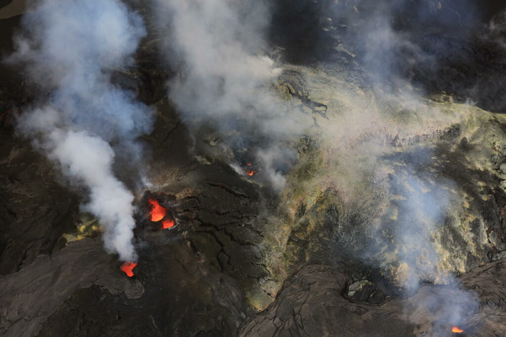 . You can use Google Translate on their website https://lechaudrondevulcain.com/
Thanks. Interesting.
From site:
“Between September 25, 2026, at 16:00 (UTC) and October 2, 2026, at 16:00 (UTC), the OVSM recorded 226 volcano-tectonic earthquakes. Ground deformation observed.” Alert state yellow. But nothing is supposed to happen right now.
There were recently some 28-35 km deep quakes (depth of the Pahala quakes) both below the SWRZ, the Koae Fault region and the wider southeastern summit region. They show that something at great depth must happen.
Today the tiltmeters go up again, f.e. SMC:
The tiltmeter shows that there were two DI events: 17th September and 30th September. Did the extrusive episodes turn into intrusive episodes for a while?
At 6am HST the south vent is looking a bit larger than I remember (v3 cam) It is the more energentic of the vents at this time. The north vent is spiting a little bit and showing flames (V1 cam). No lava flows though
A really nice overview, Hector!
The update from USGS: https://www.usgs.gov/observatories/hvo/news/photo-video-chronology-kilauea-summit-intrusion-cracks-and-ground
From the looks of it, it seems the intrusion took the same area as the September 14th-16th fissures and this even developed cracks.
In that case, if the next intrusion does take place, my bet is at this area, as the intrusion might’ve provided a new point of weakness for future intrusions, maybe even an eruption here…
It confirms Hector’s view that the intrusion went northeast, while HVO initially had it going east. Of course both may have happened in separate events. I felt that the large tilt change at UWD indicates that the dike went close to it. The latest GPS movements also indicate that the inflation is centred toward and within the north of the caldera.
Hector mentioned that the intrusion was in the caldera ring fault. Wasn’t this also the start of the current eruption in December 2024? Maybe the magma searches for new easy ways upwards.
Cracks on the northern caldera floor release of heat:
https://www.usgs.gov/observatories/hvo/news/photo-video-chronology-kilauea-summit-intrusion-cracks-and-ground
Can anyone tell if the current rate of inflation at Kilauea is comparable to the past 50+ episodes? See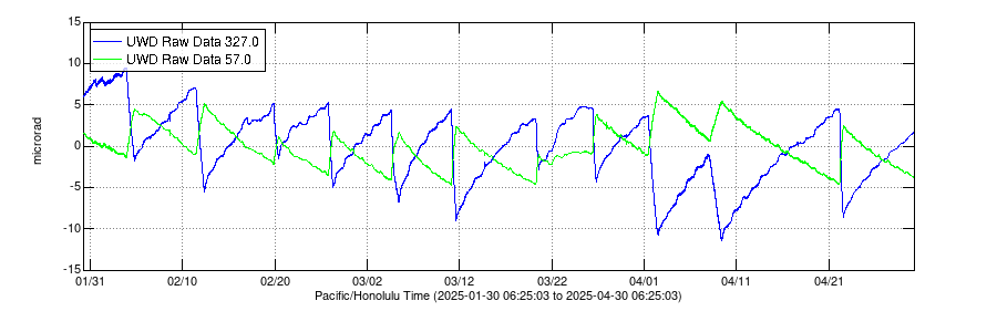 but the slope of the line as displayed graphically is really subject to the display rectangle. We need to be able to normalize this, to tell what is going on? I suspect that we are looking at the same rate of inflation, perhaps a little less, as before?
The intrusion raised the altitude of UWD station more than the overall inflation of the summit. We should rather look at the days after the intrusion. The last two days show this deformation:
If we look at the chronology since E54, we see a ~two weeks recurrence time for significant events. The “six vents” in the crater wall appeared around 15th September, and the recent intrusion on 30th September. If the temporary two week recurrence time happens again, the next something will happen around 15th October.
The inflation at the station was very limited, no more than 1-2 cm. The GPS shows this well, and the INSAR data agrees. The changes inside the caldera were much larger. There is no GPS there, but the INSAR seems to indicate 10-20cm inflation in the northern caldera.
The tilt does not measure altitude and should not be interpreted as such. The GPS is better.
What was the reason in this case that the tiltmeter jumped up by 70 microrads during the intrusion? What does it show?
It shows the difference in inflation between the two ends, which amounts to 0.07mm. The cause is the dike insertion, perhaps 500 meters away and in the caldera. A tilt meter inside the caldera and a bit closer would have measured a much larger tilt.
Here is an example. This is a Mogi model for a point source intrusion, not a dike but it shows the general behaviour. The horizontal axis is distance, the vertical is ground movement. The white dots show the upward movement, and the yellow the horizontal movement. The arrows show direction. The pink bar shows the tilt meter, which is some distance from the intrusion. At this distance, there is a small tilt which gets steeper coming closer to the intrusion but goes to zero at the centre. The UWD GPS shows a larger horizontal movement than a vertical one, consistent with this picture
Nice illustration Albert!
Just note that for a shallow dike intrusion you often get subsidence (graben formation) right above the dike, and two bulges to the sides, so it’s not a given that the tilt would be greater near the dike. It could even be negative. Often the fringes in the interferogram is dominated by the horizontal deformation. Remember that it shows motion towards and away from the satellite, which includes the horizontal component. You need to combine two interferograms taken from different orbits to truly get up/down.
I realised the possibility of deflation at the centre! That of course does not happen with a point source model. The point about the fringes is a good one. The GPS gives the correct movement at the UWD station, but we don’t have this for the caldera itself. Anyway, my point was that the tilt should not be interpreted as local inflation.
They don’t have stations in the caldera, but the hot cracks inside the northern caldera above the intrusion are a good sign. These cracks resemble the cracks above the SWRZ intrusions in 1919 and in 2024. Are these cracks caused by subsidence above the intrusion?
Consequence of it. The subsidence comes from the ground being sideways – and in different directions above the intrusion
Albert:
Thanks for correcting my thinking and providing more information which I had not considered at the time. We should not conflate tilt readings with actual volume flow.
Alcedo (Isabela Island, Galapagos) with earthquake swarm: https://www.vulkane.net/blogmobil/vulkan-alcedo-erdbebenschwarm-detektiert/
1993 was the last eruption of Alcedo, it consisted of Phreatic explosions with VEI1. It is the only volcano of the Galapagos which has some Rhyolite magma available (subordinated to its basaltic magma). https://volcano.si.edu/volcano.cfm?vn=353040
I was surprised to learn there are settlements on Isabela Island. It doesn’t look as though there any places safe from eruption.
An other-worldly look to on the V3 cam with prolific steaming coming from everywhere on the crater floor.
Yes it looks ominous…
The tiltmeter at https://www.usgs.gov/media/images/electronic-tilt-kilauea-summit-past-2-days right now ( 9 am Hawaii time on Friday Oct 9, 2026) seems to have gone in wide oscillations. What’s up?
panama eq, no?
That’s my guess.
It is the mag 7.7 Panama quake. Interesting that the tilt meter picks this up.
M7.7 under the SE part of Panama. While the epicenter was inland, thus not a tsunami producer, it also radiated more energy through the ground given it’s relative shallow depth. The immediate area has been quite aseismic in recent history, so this shock showing a slightly oblique/transform fault broke loose is somewhat of a surprise. With all the quakes around the Caribbean Plate and offshore in the last few years, it’s likely that stress has been building for quite a long time.
USGS says over 4 million people experienced strong to severe shaking…just hoping we don’t see a repeat of the recent Venezuelan catastrophe.
From the earthquake pattern, it seems to that this is an extension of the pacific fault along the coast of South America, and not related to the recent earthquakes in the Caribbean
Nice that you were not too precise with this, so I had to do a quick research.
Basically, the above of course agreed, VD gives this info for the past 24 hours:
——-
In the past 24 hours, Provincia de Los Santos has had 111 quakes of magnitudes up to 7.7:
1 quake above magnitude 7
2 quakes between magnitude 6 and 7
18 quakes between magnitude 5 and 6
82 quakes between magnitude 4 and 5
7 quakes between magnitude 3 and 4
1 quake below magnitude 2 that people normally don’t feel.
——
I think that’s a lot. La Yeguada, last eruption 1620, is about 50 km north.
The Azuero Peninsula is a piece of land of an estimated length of 100 km, ending right next to the subduction zone. Interesting setting.
El Valle which has done an Aniakchak-style eruption ~200ka is further east, Panama’s biggest strato, Baru, last eruption 1550, further west, close to the border with Costa Rica, together with Cerro Colorado (Tisingal).
There is a triple junction between Nasca, Cocos and either the Caribbean or the Panama Microplate. Lively area. I like it. Panama City at a large enough distance in the east.
The aftershocks are distributed over a line that lines up with the Pacific subduction fault along South America.
The strength of the aftershocks seems typical, with the strongest being one magnitude fainter than the main shock
They might line up with the Azuero-Soná Fault Zone (ASFZ).
https://prnt.sc/RYF-d-S5lH7P
Source for location of the ASFZ. https://www.tandfonline.com/doi/full/10.1080/00206814.2023.2191678
I think you are right. The 1904 and 1934 earthquakes further west may have occurred at the same fault, but this area must have been quiet for centuries (at least). A transform fault – I wonder what the surface looks like
If you are not comfortable following the screenshot link, you can get the same image from USGS’s latest earthquake map, selecting US quakes over past 7 days and zooming in on Panama.
https://earthquake.usgs.gov/earthquakes/map/?extent=5.50664,-83.77625&extent=10.20681,-76.78894&range=week&settings=true
Very intereresting, Merlot, Thank you. Will add on paper concerning ophiolites:
Passage from the paper you put a link to:
“Within the subduction-related, or SSZ ophiolites, Beccaluva et al. (Citation2004), recognize two main types: Tethyan and Cordilleran.”
About Tethyan ophiolites:
https://www.lyellcollection.org/doi/full/10.1144/jgs2019-129
Map from:
https://en.wikipedia.org/wiki/Panama_fracture_zone
Thank you for your answer, Albert.
It is hard for me to believe that the tiltmeters pick up signals from earthquakes 5,203 miles (8,373 kilometers) away. This is the distance between Hawai’i and Panama, straight line.
On the contrary I could vaguely imagine that there is a connection between the Venezuela and Panama quakes as the Eastern Frontal Fault System which runs from the north of Venezuela to the south of Columbia in an oblique direction borders the North Andes Microplate which borders (north to south) the Caribbean, the Panama and the Nazca Plate.
Columbia itsself seems to be consisting of terranes.
Source: https://en.wikipedia.org/wiki/North_Andes_plate
Addendum: The timing though should be accidental. Panama had more earthquakes at different dates, years apart, listing starting in early 17th century, compared to Venezuela. the gaps are shorter, the damage mostly limited. Venezuela had fewer earthquakes with gaps in between of ~50 to 90 years, all in the same area and all with higher damage and a lot of fatalities.
As usual with famous cities: Caracas (like Managua) built in the wrong place.
The title meters are sensitive to the seismic waves from earthquakes. (And they are _very_ sensitive.) Seismographs are designed to pick these up across there world, but the tilt meters can also see them. After all, that is what a wave does: it makes you tilt one way, then the other.
So a bit like a Tsunami maybe, which is also felt around the world, even in a tub. Have a nice Sunday everybody.
Btw, after reading your piece about the Venezuelan earthquakes again I checked Lake Maracaibo. Huge oil reserves and brackish water speak a very clear language. Could be another remnant of Tethys, see map. Tethys surrounded earth. We only talk about our part and the Himalayan part.
https://page-one.springer.com/pdf/preview/10.1007/978-1-4899-1558-0_1
Are there any good papers about kilauea’s post-collapse recovery/magmatic inflow?
V1 cam is looking nice at the moment
looks like we’ll be getting another cone soon haha
The firework was nicely visible around the 23:00 time on the camera. Indigestion
Found this article this morning from ARStechnica.com.
https://arstechnica.com/science/2026/10/whats-been-driving-hawaiis-lava-fountains/
“What’s driving this?
What have the eruptions told us about the mechanism that drives fountain formation?
One leading idea is that pressure within a magma reservoir keeps water mixed with other materials until it reaches a shallow enough depth to exit as steam. That fragments the magma, which allows it to ascend more rapidly, which allows more steam to escape, and so on until there’s a jet of material near the surface. The alternative posits that things are driven by the release of carbon dioxide from the magma, which forms a magma/gas “foam” at the roof of the magma chamber. Once this reaches a critical point, the gas escapes, driving magma with it until the supply in the magma chamber is exhausted.”
“While Kilauea has proven itself as a spectacular lab for studying volcanic activity, it hasn’t yet proven ready to give up all its secrets.
Science, 2026. DOI: 10.1126/science.aef2931”
The paper
https://www.sciencedirect.com/science/article/pii/S0377027326002222
I have the impression that the southern vent hosts a convecting lava lake that goes up and down depending on Inflation/Deflation. But while the old 2008-2018 lava lake usually rose effusively, the current lava lake rises with gas bubbles that do Strombolian bursts and spattering. The current magma in the summit region looks still more gasrich than 2008-2018 or 2020-2023. It’s more like Kilauea Iki’s magma 1959 (that 1960 also erupted in Kapoho), the 1969 Mauna Ulu magma or the 1983-1986 Pu’u O’o magma.
Do they still measure Magnesium content to find out, how primitive the magma is?
I got this strong impression too, several nights ago watching the north vent and the gas cloud being emitted, during a night time epsode, when suddenly “huffing and chuffing” occurred and the gas cloud both exited, then suddenly reversed direction and went backwards to the vent. This was very startling to me at the time and made me wonder if the surface of the lava below was oscillating.
I didn’t know that Hekla 2000 did a long fissure eruption: “A fissure 6-7 km long opened along the SW flank of the Hekla ridge, from which a discontinuous curtain of lava erupted starting at 1819” This effusive fissure eruption started six minutes before the more famous explosive eruption. https://volcano.si.edu/showreport.cfm?doi=10.5479/si.GVP.BGVN200002-372070
Was the source for the explosive ash eruption a point along the effusive fissure or outside of it?
Google Gemini replies:
The source for the explosive ash eruption was a point directly along the effusive fissure, rather than outside of it.
Volcanological studies of the February 26, 2000, Hekla eruption show that the 6.6 to 7 km long eruptive fissure that opened across the Hekla ridge divided into several distinct segments:
The Explosive Source: Segment 2 of the fissure (located near the summit area) was the very first part to open. This specific section acted as the vent that powered the initial explosive Subplinian phase, generating the high ash column and tephra fall.
The Effusive Source: As the eruption progressed within minutes to hours, the fissure propagated across other segments (such as segments 3, 4, and 5) along the SW and NE flanks, feeding extensive curtain-of-fire lava fountains and lava flows.
In short, the explosive activity and the effusive lava flows came from different segments of the same continuous fracture system rather than independent, separate volcanic systems.
caveat: AI can make mistakes, be aware.
Hekla is a bit like Mauna Loa: it is a rift volcano with a similar ‘whale-like’ shape
Unlike Mauna Loa it lacks any central crater or caldera. Hekla is the only major Icelandic volcano without a caldera. Is it because the magma chamber sits too deep to cause a caldera depression on the surface?
it is too young and growing too fast
Hekla 3 eruption deposit ( 7km3 of dense material ) likely erupted in just a matter of days! or likely the first hours a few 1000 years ago during the bronze age in Europe .. it was an eruption in energy and eruption intensity that makes Laki look like an complete aftertought and most of the materials maybe erupted in the first hours. The whole Iceland was under a dark mammatus ashy cloud shield with a 30 – 40 kilometer high fiery lightning filled column rising to the stratosphere alot of that column incandescent at night … ash and evolved pumice falling everywhere in south and central Iceland and incandescent pyroclastic currents
This prehistoric eruption occurred around 1000 BC (frequently dated by various models between 1159 BC and 929 BC) and operated as a massive, short-duration Plinian phase of Hekla
Its the most intense Hekla eruption ever known
But Sakursunarvatn and Vedde Ash maybe much faster still in eruption rate
Hekla is actually the “Vesuvius” of Iceland with the threat of sudden explosive eruptions as Pompeji experience 79 AD, although the big silicic explosive eruptions happened in the distant past.
Did these actual Plinian eruptions of Hekla construct craters or a caldera that was filled later? Hekla is very productive over long time, so it may be possible that it/she buried explosive craters/calderas.
Hekla explosiveness could be due to contact with water reservoirs. I remember watching a while back that some inflation at Hekla was detected by affecting the water table.
If you have darkness and clear skies it might be worth looking up about now
Space Weather Message Code: ALTK07
Serial Number: 219
Issue Time: 2026 Oct 10 1758 UTC
ALERT: Geomagnetic K-index of 7
Threshold Reached: 2026 Oct 10 1758 UTC
Synoptic Period: 1500-1800
Active Warning: YES
Noaa Scale: G3 – Strong
Comment:
NOAA Scale: G3 – Strong
Less than an hour ago, the secondary vent near the north vent at Kīlauea has begun to spatter and now is producing lava flows, abiet they are slow so far. Looking back at events before, the other vents would overflow until something happens, either fountaining or an intrusion that may or may not lead to a eruption somewhere else…
Unlike the old overflow episodes, this has developed into continuous slow lava effusion. There is a hole below the current level of the lava in the cone
It has become a new small hornito comparable to the bigger north vent hornito. The caldera hosted many hornitos, lava lakes and ponds in the 19th century. It was like an effusive complex volcano inside the caldera.
The subordinated vent to the northern vent (or the new nothern vent?) does every few minutes small but aggressive lava fountains that in small size and their horizontal direction resemble some of the giant tall lava fountains in spring that hat a horizontal direction. The magma pipe below the vent is likely not vertical but somewhat diagonal and causes a left-leaning lava fountain (from V1cam perspective).
Today the southern SDH tiltmeter inflates stronger than the other summit tiltmeters. There did also occur small quakes along the valley that leads out of Kilauea’s caldera (between AHUP and OUTL GPS stations). The most shallow quake was 390m above sea level.
Otherworldly, awesome picture
thank you albert.
One of the saddest things in the world is that Jules Verne couldn’t see pics like this one, from Hector’s piece about Aleutian Arc (reading 20.000 miles again, what a creative genius he was):
This though he might have seen and appreciated:
Pic from this fine piece:
https://www.volcanocafe.org/icelantic-growing-a-nation/
The slow flow is still continuing. The flow field is slowly growing, which you can see when comparing images from V1 camera over a few hours. (The camera is also slowly tilting down a bit..)
HVO states that this vent produces cool, degassed magma which may be part of the lid sitting above the hotter, fresh magma. It may take some time to see how things evolve
There is a small swarm at Kīlauea at the moment, I think. It is to the south of the caldera and the spattering has also stopped. Looking at each earthquake depth, they seem to be 1-2 km below sea level, likely the south chamber.
On that note, all tiltmeters seem to be pointing towards the caldera (and likely still is at the moment). Reminds me of that event somewhere last year when something similar happened. Maybe an extreme DI event is occurring at the moment…
I think that we’re in a transitional period between 1. the Fountain phase and 2. the Continuous eruption phase. Mauna Ulu needed six months for this transitional phase (January to summer 1970). The current transitional phase can be shorter than the six months of Mauna Ulu, but the behaviour may be similar.
During the first six months Mauna Ulu did only little volume output. There were some short overflow events, but they lasted one day or so. In the summit region and upper middle ERZ (Mauna Ulu) the transitional period is longer than in the lower middle ERZ (Pu’u O’o). I suppose that the shortterm lava tube eruption yesterday was an example for this and that we can expect more like this … until after several months a major effusive eruption follows.
For comparison with Mauna Ulu 1970 I’ve looked for the chronoly January to July 1970 https://volcano.si.edu/volcano.cfm?vn=332010&vtab=Eruptions
The last lava fountain was on 31st December 1969. After that Mauna Ulu was quiet for some weeks.
1970 Jan 29 to 1970 Jan 30 Lava flow At about 2100 29 January the summit recording tiltmeter showed the start of slow, steady deflation and sometime thereafter the vent between Aloi and Alae began a moderate welling of lava with very little fountaining. This mild activity continued until about 1530 to 1600 on 30 January when overflow ceased and drainback took place.
1970 Jan 30 to 1970 Jan 31 Deformation (inflation) The summit tiltmeter showed the resumption of inflation about 1530 that continued at least until 1000 31 January. The lava has risen again in the vent but is not overflowing at this time.”
1970 Apr 9 to April 10: Fissure in Aloe Crater, but also lava flow and lava lake in Mauna Ulua
Then a break without any effusion until July 6: Since then, eruptive activity from this fissure has been more or less constant
We have some more vigorous spattering at about 3:20 am HST
Odd. Seems like something is happening there and the deflation/earthquakes may have something to do with the increase in activity, more active than the day before. This looks like a extreme DI event, of which the cooler magma finally dropped and the fresher magma rushed in, causing more magma to be extracted from the lower reservoir and, as soon as the deflation turned to inflation, the vents began to be more active.
The flaming is now coming from type lower vent. So the lava level is still down. The lower vent is also doing some impressive jetting at times
There are likely also some short and small lava tubes. It is difficult to observe them, but during the night there were some lights from possible lava exits.
Milton High school.. Santa Rosa County Florida… is pretty much gone .
I am glad you are ok. The hurricane did quite some damage in the region
small fountain from north vent
started at around 11:24 from the nirth vent as a drizzle now coming out of the auxiliary north vent.
There are lava flows towards both the V1 and V3 cameras.
And now fountaining! Or at least trying
There is a new quake near OUTL
2026-10-12 21:28:42
Earthquake
Magnitude: 1.83 M
Depth: 1.31 km
11:28 am HST time
Actually two quakes 11 seconds apart.
2026-10-12 21:28:31
Earthquake
Magnitude: 1.90 M
Depth: 0.87 km
Looks like it’s getting more intense on the V1 cam.
jetting now from the top vent
And now all fountaining stopped. Well, it’s better than nothing.
and the fountain collapses. I think we are back in business – this is just like the old days in the run-up to an episode. Wait and see
Lava flow from the v1 camera side did reach the floor. Barley see it on v2.
New lava flow from the north vent starting now.
More fountaining underway now. Small lava flow over the top of the cone.
missed it, again ….
This is still the precursors, equivalent to the overflows of the past. You may still get to see one today!
If not, here is what you missed
The youtube live stream buffers 12h of video, so you can easily rewind it and have a look.
https://www.youtube.com/live/HggWKlZv9yk?is=k18whya2wO5QH0bP
SDH is at the moment more positive than other summit tiltmeters:
” The summit wide deflation that began yesterday at noon and ended at midnight was associated with a cluster of small earthquakes in the south caldera region. This pattern indicates that magmatic pressure is continuing to activate weak areas beneath the summit. It is possible that another fountaining episode from the north-south vent complex could occur; however, intrusive activity underneath Kaluapele is also possible, or magma could exploit existing weak crack systems in the summit region to erupt passively (with little or no seismicity or deformation). ”
https://www.usgs.gov/volcanoes/kilauea/volcano-updates
New article is up. US’s deadliest eruption, which was a before-and-after in the volcanic behaviour of Kilauea volcano:
https://www.volcanocafe.org/the-1790-keonehelelei-eruption-of-kilauea/