
Westfjord, where Iceland began
Growth is in. Politicians and leaders (not always the same thing) want their country to grow. Nowadays this normally means economic growth: the wish to become more wealthy. It would make those leaders more popular, and may provide them with more resources to spend on whatever leaders spend money on. In the very different world of the past, population growth was seen as a good thing. More people would make the nation more powerful and help it to win wars. The eastern Roman empire began to fade after the Justinian plague robbed it of its people and left the armies too small to secure its huge territory. Nowadays we see the fallacy in that policy, as unlimited population growth brings its own collapse, as Jared Diamond has pointed out in several case studies. Economic growth too has its issues, as it depletes our limited resources. The Club of Rome calculated already in the 1970’s that our economic growth would exceed the resource capacity of the Earth by the year 2100. Although the details of their models have changed, and modern technology making much more efficient use of those resources, the conclusion still holds. And of course, the ultimate growth is in size of the nation. For a nation to physically grow, it needs to swallow its neighbours, sometimes openly so (Russia), sometimes more circumspect (China).
All these growth areas are linked. The Babylonian empire spend enormous amounts of money it did not have on building its capital, Babylon, still remembered in our language even though nothing remain but some ruins. To finance the building of Babylon, the empire continually conquered other nations in order to take their money. This became a pyramid scheme with inevitable outcomes: their empire did not last long.
Interestingly, in democracies the tendency goes the other way. Swallowing other nations dilutes the voting power of the original population. Therefore, democracies are more likely to fragment into smaller nations than to grow into bigger ones. Germany is a rare example of a growing democracy, helped by the fact it is a federation rather than a monolithic country.
The final way to grow is by physically creating new land. This was pioneered by the Dutch, but is hampered by the fact that most people are reluctant to live below sea level. But sometimes new land comes naturally. An island may appear where none existed before. A lava flow may create new land or raise existing land. The opposite can also occur. Krakatau was lost twice within 140 years. Hunga Tonga is half the island it used to be. India is still losing a few centimeters of length every year, as it rams into Asia with the same effect as a crumple zone in a car: what India is losing in length, the Himalayas are gaining in depth. The Earth gives and the Earth takes away. It too puts limits on our growth.
Iceland may not look like a growing nation. Stuck in the middle of the North Atlantic, is has long reached its own limits to growth. The population remained constant (with ups and downs) from the end of the settlement era (think Eldgja) to the first world war, limited by severely constrained food production. Growth only resumed once improved transportation brought the rest of the world within traveling and trading distance. But Iceland is perfectly placed to gain from the Earth’s bowel movements. 30 million years ago, it did not exist. Everything you see in Iceland was created since. The oldest rocks are a little over 20 million years old. The youngest are from August.
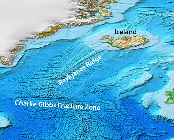
The Mid Atlantic Ridge

Bathymetric map of the Atlantic Ocean. Click on the map for higher resolution
Iceland is part of the Mid-Atlantic ridge, the spreading centre from which the ocean formed. It runs from the southern ocean (the oldest part) to the Artic ocean where it is younger than the dinosaurs. It shows the typical pattern of a 500-km wide ridge, rising 4 kilometers above the surrounding ocean, with a rift valley at the crest. There are nine islands or island groups along the Mid-Atlantic ridge, from Bouvet island at the southern end to Jan Mayen in the north (both owned by Norway). The other seven are from south to north: Gough Island, Tristan da Cunha, St Helena, Ascension Island, St Pauls’s rock, the Azores and of course the only independent nation on a mid-oceanic ridge, Iceland. The ridge gives a broken appearance: it consists of short ridges separated by small sideways jumps. The jumps have formed longer faults running perpendicular to the ridge. These stripes disappear north of Africa where the ridge borders the Eurasian plate rather than the African plate. The ridge here has a single large eastward jump, at the latitude of southern Ireland. A little further north the ridge turns towards the northeast and changes appearance. The brokenness disappears and the ridge become smooth looking. There is also no longer a central valley. Eventually the ridge reaches land at the Reykjanes peninsula. The smooth section is called the Reykjanes Ridge.
The Mid-Atlantic ridge is a pure spreading rift, with the offsets acting as transform faults. This changes as it reaches the Reykjanes peninsula: here it becomes a combination of a spreading and transform fault. It re-enters the ocean north of Iceland.
The brokenness shows that the oceanic crust around most of the Mid-Atlantic ridge is brittle and cold. The smoothness of the ridge near Iceland shows that the crust here is much more ductile and warm. It shows the effect of the Iceland hot spot. And because of the warmth, the density of the rock and mantle is a bit less, and this pushes up the ridge. The ridge becomes shallower and eventually surfaces. This is how Iceland first formed.
To understand this more easily, try to find a newspaper. (For younger readers: a newspaper used to be a paper that described what was happening in the world. Nowadays a newspaper tells you what the editor wants you to think about it.) Try to tear the newspaper by pulling both sides apart. Do this against the grain of the paper (as you may know, paper will tear easily only along one direction, the direction of its fibres. Try the other way.) You will get an irregular tear, continuously going off in unwanted directions. Now make the paper moist and try again. It now tears much more regularly.)

Magnetic anomalies on the ocean floor near Iceland. (Note: this figure is rotated such that ‘up’ is northwest. Source:
Encyclopedia of Geomagnetism and Paleomagnetism, 2007
The spreading of the ocean floor is directly visible in maps of magnetic anomalies. At irregular intervals the earth’s magnetic field reverses. The direction of the magnetic field is engrained in the ocean floor. Iron particles in the magma acts as mini compasses, and when the magma solidifies this freezes into the rock. So when the Earth field reverses with magnetic north and south changing places, now the frozen magnetic compasses point the wrong way. The iron particles causes their own magnetic field: there is now a magnetic anomaly. When mapping these anomalies, they show up as stripes parallel to the spreading axis. Each stripe is a memory of what the field was when the rocks formed. This was the conclusive evidence that the ocean floor is alive. It is born in the rift, drifts outward, and finally dies in the subduction zone. (The latter is not yet happening in the Atlantic Ocean: it is much too young to subduct.) The fact that the stripes are parallel shows that the spreading rate is approximately constant along the rift. It is around 2 cm per year, or 20 kilometers in a million years.
The migration of the Reykjanes Ridge
The spreading in the Reykjanes Ridge is not entirely symmetric. Currently, the Eurasian plate receives a little more new crust from the ridge than the American plate. Between 6 and 15 million years ago it was the other way around. Asymmetric spreading indicate that ridge is migrating, and the change 6 million years ago may indicate that the ridge jumped from one location to another, with the crust in between changing plates. As a result of the asymmetry, the shallow shelf surrounding Iceland extends 50 kilometres further on the American side of the Reykjanes Ridge than it does on the other side.

But there is something else funny going on south of Iceland. There are ridges in the ocean floor on either side of the rift, forming a ‘V’ pattern like a flock of migrating geese. The show up particularly well on gravity measurements, as shown in the figure. A variety of explanations are available: there is some dispute around their origin. One obvious explanation is that the spreading rate increases towards Iceland. But this is not the case, since the magnetic stripes remain perfectly parallel. Perhaps the Icelandic plume pulsates, an each pulse slow propagates down the ridge, formed a higher ridge in the process. But there is no other evidence for such pulsating behaviour. Others have suggested it is related to relocations of the ridge. The western edge of the band runs roughly along the main direction of the Mid-Atlantic Rift, along the rough fjord-like coast in the far northwest called Vestfirdir (Westfjords) which looks like it should be a part of Greenland. Other segments line up with the two peninsulas on the west side of Iceland, and one extends towards the south coast near Katla. The idea is that these are mini-rifts which begin to form near Iceland and propagate towards the weakest point where the Reykjanes Ridge begins. These mini-rifts compete to become the true Mid-Atlantic Ridge.
This gives a model where 15 million years ago a mini-rift began to move southwards from Iceland, in the process transferring a block of ocean crust from Europe to America. A second mini-rift developed from Iceland 10 million years ago, another followed 6 million years ago and a final one came 4 million years ago. Each rift transferred as much as 10-15 kilometers of crust to the other plate.
Paleo spreading centres

Map of Iceland created by Tom Wallace for Volcanocafe – based upon map found on https://data.geus.dk/nordiccs/geology.xhtml
Iceland is a volcanic nation. The map above, taken from the Mammoth guide and made by VC’s Tom Wallace, shows the main volcanoes. The colour of the triangle indicates how likely it is to erupt. Beware of the power of VC: this map was made in 2017, but it shows the Reykjanes Peninsula at enhanced risk – well before it unexpectedly began to shake and erupt after 800 years of solitude. I just mention it. (We also managed to postpone the Reykjanes eruption by a year, as you may recall.) The map shows that the volcanoes cluster. Not all of Iceland is equally affected.

RR, Reykjanes Ridge; RVB, Reykjanes Volcanic Belt; WVZ, West Volcanic Zone; MIB, Mid-Iceland Belt; SISZ, South Iceland Seismic Zone; EVZ, East Volcanic Zone; NVZ, North Volcanic Zone; TFZ, Tjörnes Fracture Zone; KR, Kolbeinsey Ridge; ÖVB, Öræfajökul Volcanic Belt; SVB, Snæfellsnes Volcanic Belt. Source: Wikipedia
Deleting the volcanoes shows the underlying pattern. There are several main fault lines. The Reykjanes Ridge links to the Reykjanes Volcanic Belt which continues into the West Volcanic Belt. On the other side of Iceland is the East Volcanic Belt which continues into the North Volcanic Belt and continues as the Kolbeinsey oceanic ridge towards Jan Mayen. The WVZ peters out to the north and EVZ peters out to the south. The two are connected by a transform fault, the South Iceland Seismic Belt. There is also a transform fault indicated connecting the two further north but there is not much evidence for this. The enormous Hofsjokul volcano is located on this line, but transform faults do not form volcanic centres. Other descriptions instead pose a Central Iceland Volcanic Zone (CIVZ) which links Hofsjokul and Tungnafellsjökull system. Finally, there are two less active and disconnected volcanic lines, the Öræfajökul Volcanic Belt in the far east and the Snæfellsnes Volcanic Belt in the west. Each volcanic zone consists of several parallel lines of activity, separated by 10 kilometers. Individual volcanoes tend to be some 20 kilometers apart.
Activity varies. The EVZ is the most active, and the two kilometer high bulge in the landscape suggests that this is the current location of the heat source. The NVZ and the extension of the EVZ into the ocean where it peters out (this is actually the region that was land during the ice age) has less extreme activity. The latter region is sometimes called the South Iceland Volcanic Zone (SIVZ). The WVZ is not nearly as active but can do significant eruptions – the next one will come as a surprise. The two isolated belts have very infrequent eruptions. Finally, the Westfjord area (connected to Iceland only by a narrow isthmus) has no volcanic activity but has old many basaltic lava flows. There was a rift here similar to the modern Reykjanes peninsula, between 8 and 15 million years ago but it has long since died.
Age is important. The EVZ became active only about 3 million years ago. Before that, the WVZ was the prime mover. The Hofsjokul region may have acted as an intermediary. All three remain active. The WVZ still accounts for about a third of the spreading rate in Iceland with the EVZ accounting for the remainder, while the parallel fault around Hofsjokul showed some activity during the 1996 Gjalp eruption. The Snæfellsnes Volcanic Belt is older again. It still contains volcanoes but these are more recent activity (form the last million years) sitting in a much older volcanic platform which existed from 16 million years to 6 million years ago. The region re-activated more recently, perhaps related to the ice age.
Iceland is moving. Compared to the hotspot, the area (including the spreading ridge) is moving at around 5 millimeters per year NW. This means that the hot spot appears to be moving to SE. Going back in time, we can put an approximate track across Iceland.

It is to be expected that the volcanic zones migrate with the hot spot. Five million years ago, the WVZ was well placed for the hot spot. Then it slowly moved away, and 3 million years ago it was far enough that the WVZ began to lose magma supply. This was the time the EVZ began to develop as a flank rift, and it gained in importance as the hot spot approached. But even now, the WVZ still accounts for a third of the spreading. Old rifts die very reluctantly. The OVB seems to have developed as a flank rift, situated on the edge of the hot spot bulge. Perhaps on the future it will begin from direct interaction with the hot spot but that is still 1 or 2 million years away. We need to be patient.
So 5 million years ago the paleo spreading centre was somewhere near the tip of the WVZ, and 15 million years ago it was on the Westfjord region. It was never near Snæfellsnes or Reykjanes. So why were or are these regions volcanic?
The answer seems to lie in the ridge propagation. Let’s go back in time. 25 million years seems about right. At that time Iceland was still close to Greenland. The Mid-Atlantic Ridge followed its original course, tracing where the separation had occurred. This follows the western most ridge of the ‘V’, and runs along the Westfjord coast. Of course this wasn’t yet a fjord coast: the fjord formed much later from ice age erosion.

Over time, the hot spot moved east. This made is much easier for the crust to rift in this location, made ductile by the heat. 15 million years ago, the ridge began to bend toward the new location of the hotspot. This may have initiated as a mini-rift running south from the what is now the Snaefelness peninsula. The Atlantic ridge relocated a bit eastward.

5 million years ago the hot spot arrived at what is now the WVZ. This now became Iceland’s main spreading centre. A new mini-rift began to run south from what is now the Reykjanes peninsula. The Atlantic ridge gains jumped by a few kilometers to connect to this mini-rift. The Reykjanes peninsula began to form and the Snaefelnes peninsula died a volcanic death.

5 million years ago
Nowadays, the EVZ has become more important. A new mini-rift may be developing, although if past behaviour holds it won’t be from its southern extension but further west, perhaps from the weakness that is the WVZ. In fact the Icelandic shelf already shows a small extension along this line, connecting to another part of the V’.
Growth
As the Icelandic spreading centre has moved east, it has created new land Iceland is growing both to the east and west. The spreading is symmetric and creates land in both directions equally. But the host spot is moving east and this introduces an asymmetry. Most of the created land is now on the west side of the host spot. This make the connection to the Mid Atlantic Ridge more and more difficult. It explains why the Reykjanes Ridge has been relocating, accommodating an increasing diversion. The relocations begin on Iceland itself, where new rifts develop and new volcanic centres grow. Now mini-rifts extend into the ocean. It seems this is not a regular process. The ridge 15 million years ago transferred a part of the oceanic crust from Europe to America. But subsequent jumps have been smaller. The Reykjanes Peninsula sticks out almost as far east as does the Snæfellsnes peninsula. From the details of the ridges, it appears that there have been several ridge jumps, but they have jumped in either direction, east or west. At times the ridge even ran further east than it does now. .Every time a jump happened, the spreading took the ridges apart, and as the new rift propagated south, it formed a ‘V’ sign in the ocean – and Icelandic victory, growing new land without causing political problems.
The current Reykjanes Ridge has survived for more than 5 million years. But there is trouble afoot. It is a long way form the tip of the Reykjanes peninsula to the EVZ, and this includes a long section of pure transform zone. A new mini-rift south of Reykjavik may help: it would follow a weakness that has already been created. But it is far from the spreading centre in the ocean, and that means the rocks here are not as warm as they used to be. One day it will become too difficult to break these rocks. When that happens, Iceland will leave the Mid-Atlantic Ridge behind and lead an independent existence. No longer will it straddle the boundary between Europe and America, but it will nail its flag to the European side, following the Faroer.
And when, perhaps 50 or 100 million years from now, a subduction zone forms along the continental shelf north of Scotland, Iceland will be pulled into the abyss and the time of growth is over. There will be limits to its growth.
Albert, October 2022

Icelantis


Wonderful article Albert, interesting that in around 50 to 100 million years time, Scotland will be very different place, with a subduction zone just north of its continental shelf, how big will that subduction zone be?
My timeline might be optimistic. But the Atlantic ocean will not last forever. 200 million years is about maximum: then it has cooled so much that it begins to sink into the mantle. Subduction could start on either side of the Atlantic, of course. Northwest of Ireland and Scotland lies fragmented continental shelf with breaks. In a vague suspicion, my feeling is that subduction would first start in Biscaye and along south of England and Ireland. This will pull on Europe and cause it to rotate, leaving the broken bits of shelf behind. Eventually the UK will be oriented east-west and now the subduction will extend towards Scotland. But this is just a dream. Any other suggestions? Volcanic islands do tend to find their nemesis in subduction zones, with just some remnants plastered on the coast.
Was not there an article ‘recently’ suggesting that subduction might already be starting of the coast of Portugal?
Yes, but I didn’t buy that. Lack of evidence and it seems too early. The Atlantic ocean isn’t old enough. There is a subduction-like feature in the Gulf of Mexico though.
Wait, ain’t there already one to the east of the Lesser Antilles island chain?
Yes, but that is not an Atlantic one! It is a fragment of the Pacific ocean which has broken through into the Atlantic
Funny thing, at the time this article is published a seismic swarm is starting at reykjanes ridge.
Yes, instant effect! The power of VC. Swarms here are not unusual though
Nishinoshima resumed eruption If anyone is curious
NASA’s picture of the latest eruption of Nishinoshima
Text and picture found here:
https://earthobservatory.nasa.gov/images/150489/nishinoshima-clears-its-throat
There was just a mag 3.1 quake at the summit of Mauna Loa, just southwest of Mokuaweoweo.
And at Kilauea Pu’u O’o has stopped deflating.
Possibly also some magma movement in the far ERZ, just west of highway 130, data is very fuzzy though so hard to tell on this one.
Thanks for a really fascinating article Albert! I have wondered for some time about the fan shape of the Rejkjanes ridge. An extremely plausible explanation. I wish I could be around to see the way it will all pan out in even a few thousand years. However the years are marching on and my body is now only stumbling along, so I love to have this possible glimpse into the future for Iceland. Many thanks again.
OT: New Zealand’s GNS Science (who is keeping track of Whakaari / White Island) was found not guilty for not accurately predicting the dangers of Whakaari / White Island in 2019, when the fatal eruption killed 22 people and injured 25 others. After all, they had raised the alert level shortly before the accident from 1 to 2.
https://www.nature.com/articles/d41586-022-03268-5?utm_source=Nature+Briefing&utm_campaign=dbeda7b692-briefing-dy-20221017&utm_medium=email&utm_term=0_c9dfd39373-dbeda7b692-44800453
Other agencies haven’t always fared well in the courts when people got hurt from volcanoes or earthquakes (e.g. the Italian earthquakes in L’Aquila in 2009).
Prosecution over the Italian earthquakes was nonsense. However if there was some heightened unrest with Whakaari this should have been forwarded to the tourist operators rather than a ‘ah it’ll be okay’ attitude.
Heads up to UK VC – brilliantly nerdy Volcano program on BBC 4 right now, currently talking about the rarity of rhyolitic eruptions…
https://www.dailymotion.com/video/x6x2b6b
If only we had a time machine akin to H.G. Wells’, or a TARDIS.
Alas 100 years is not enough to see the geological future come to fruition.
So we can only speculate.
Is it more likely for a subduction to zone to develop:
a) around Iberia
b) off the coast of Norway
or c) to extend from the subduction zones in the west atlantic, namely in the Carribbean and Scotia/Shetland
Some noise around Hekla. Keeping an eye on her!
Yes that might even be the swarm with the most quakes for the past 6 years, certainly at the edifice itself.
On the front of which one goes next in Iceland I am still secretly rooting for Herdubreid, there was a small swarm there too. Other ones to mention with slightly more quakes than usual in the past week are Askja, Bardy, Grimsvotn and Katla (Rejkanes, Tjörnes). It seems the popular “pillow” is pushing against Iceland from below once again, let´s see if something gives way this time! Hoping for some more events with a greater depth though..
Hekla probably doesnt do deep precursory quakes, its magma supply seems very constant at a slow rate and is created from a rift and transform fault interacting rather than high mantle temperature. Its probably pretty different to Vatnajokull (or Hawaii) where magma injection is more forceful, its more like the mantle flows in to fill the spot and melts, creating the volcano. It might also be why Hekla and Vatnafjoll can have different and unrelated magma composition while occupying the same rift.
Should say, this doesnt mean melting is at a low degree, the rate of partial melting is probably only slightly lower than that of Vatnajokull, given that Hekla is the second most productive of all the Icelandic volcanoes and probably the one with the most consistently big eruptions.
I also think the lack of quakes is actually a heavy argument against Hekla being an open system to the surface. Open conduits tent to be pretty seismic when under any amount of pressure, unless the volcano in question is truly completely open with unobstructed flow. Hekla is mostly effusive but the eruptions begin with an extreme intensity that requires a lot of pressure, open conduit volcanoes dont tend to just randomly do VEI 4s, those happen when such a conduit is first formed. The lack of warning might also be a recent phenomenon, the 1846 eruption had felt quakes a day before.
A few harmonic tremors if I am not mistaken…
Albert? Carl? Is my reading of the drum-plots correct?
I really have to move away from relying on Volcano Discovery, especially after the Öræfajökull debacle. Also their quake stats, especially for volcanic quakes, are wildly incomplete and often doesn’t seem to pick up certain activity.
While I’m going to be in Iceland (we leave Sunday!), what’s the best page for me to see quake activity for Hekla, Katla, Grimsvötn, etc?
Is there any that summarizes quakes daily or is it only sites to the tremor plots? If so, I’ll have to brush up on reading them. Appreciate any advice! Getting very excited!
And Albert, fantastic article as always! You’re really quite prolific; putting together vast, different infotainment pieces about a week apart! Impressive. Was a great primer for our trip.
https://vedur.is/skjalftar-og-eldgos/jardskjalftar/reykjanesskagi/
For the english version, see
https://en.vedur.is/earthquakes-and-volcanism/earthquakes/
Thank you both!
There is this. https://vafri.is/quake/
Unfortunately, it is written in Elvish that few can understand. However, it is very easy to navigate. As soon as you learn where each bit is, the Elvish becomes manageable – even though I still can’t understand it.
Not related to volcanoes at all, but I found this video very interesting. I was always a bit confused on how to actually generate electricity from a fusion reactor but it seems that is only a problem of the research designs not something fundamental.
https://youtu.be/4GJtGpvE1sQ
And all we need to do is enough to cover the base load, renewables and storage can cover the rest, its not like there is only allowed to be one way to generate energy like the opposition likes to claim… 🙂
Mauna Loa 10 year GPS deformation, showing the beginning of the current unrest period in 2014. Plots for MLSP, one of the two stations on opposite sides of Mokuaweoweo. The other doesnt seem to be available right now.
To date there is 35 cm of inflation, which is a lot considering the structure of the magma systemseems to indicate most of it is not under this station… It is also comparable to the amount Kilauea has inflated by since 2018, although that is not exactly equal given the inflation at Kilauea is alongside actual eruption too.
Still, the rate is approximately 1/4 the rate of what Kilauea did 2018-2020 when it was also not erupting. That may be a rough guide to how much magma Mauna Loa has actually been getting. That would give about 0.25 km3 of magma in the past 10 years, maybe 0.2 at a lower bound, added to the estimated between 0.2 and 0.4 km3 added in the 2000s deep intrusion and an unknown but not negligible amount added between 1984 and 1993. At least in terms of absolutes there is now way more magma in the volcano than what was there in 1984, although it is not all in the shallow magma chamber.
Still expecting a summit only eruption but this is going to be big. The summit of the volcano is going to light up like a portal to hell when it begins. Initial eruption rates in 1940 and 1949 are given numbers of 40 million m3/hr, or over 11,000 m3/s, basically a plinian eruption without the explosion…
Oh the plots are all one image… can someone fix it 🙂
I tend to look less at patterns and instead fall back on randomicity.
Both the volume and duration of the 1975 eruption were found wanting in comparison to 1940 and 1949. What does that mean? Can we draw inferences?
There were a number of observers that thought 1975 was going to resume eruption downrift based on earthquakes in the week after the eruption stopped. What does that mean? Can we draw inferences?
Both Moore’s Law and government largesse mean that every generation has more technology at hand than the one before. When you combine that with the fact that ML erupts…once a generation…but for now, I think that we’re in a both frustrating and glorious time where the more we know…the less we know! Maybe in 500 years, after twenty more ML eruptions, we’ll have Pele figured out!
ML historically erupts something like 5 times per “generation” (assuming 30 years for that duration). In 500 years, we could expect almost 100 eruptions, probably re-paving much of the mountain!
It does that when it is active, like it was from 1840 to 1950, but it is much less often between. It does confuse me when HVO says the current 38 year gap is ‘unprecedented’ when historical time in Hawaii begins in 1790 and the only Mauna Loa eruption reported before 1843 (53 years later) is a dubious observation in 1832, which is still over 40 years after 1790.
Same for Kilaueas ERZ, very active from 1955 to 2018, but almost quiet before then back to the early historic period. Kilauea summit seems to stay pretty consistent though.
Kilauea does actually have an average resurfacing rate not far off of that number though. Since the first human arrival about 1000 years ago Kilauea has nearly totally resurfaced. Only 0.5% of Kilaueas surface is pre-Holocene, down at Pu’Ukahone, and the top of the hill above Halape.
Mauna Loa has a similar rate of surfacing and actually has covered more area than Kilauea, but that is mostly because its eruptions are intense so lava flows a long way for a small volume, the volume in total seems to be quite a lot less than Kilauea with few cases of actual shield building at Mauna Loa in the relevant time.
Total area covered in Hawaii from all 3 active volcanoes since 1000 AD is around 3500 km2 which is more than 1/3 of the whole island. So basically if you want someone to see your house there in 1000-2000 years build it on the north side of Mauna Kea or it will probably not make it… 🙂
Every 3 to 6 years is Mauna Loa avarge since 1840
I’m being pessimistic by thinking 38+ years, it’s worked for me so far!
It was that often between 1843 and 1950, when it was very active. But it is not that active now, probably the next eruption will be followed by a long gap again.
Before 1843 was a big gap too. There are reports from Maui of an eruption in 1832 but no one on the Big Island saw it… The Manuka flow down near Ocean View has an average radiocarbon date of ~1809., so it is at least decades older than the 1843 flow, and younger than Cook’s visit. There was also a radial eruption directly north of Mokuaweoweo in the saddle area, that is given a date around 1750 but without sources. But basically before 1843 Mauna Loa had infrequent eruptions like it does now and the historic period has major observation bias.
WV from Hunga Tonga is remaining in the stratosphere and mesosphere… not unlike other volcanic effluents.
ATTM, I am keen on learning what effects a greenhouse gas layer (WV) above the tropopause can have on weather conditions in the lower troposphere. Class continues in session.
Not sure if you saw this Craig (it may have been posted / discussed here and I’m not remembering), but check this article out:
https://www.severe-weather.eu/global-weather/cold-anomaly-stratosphere-polar-vortex-volcanic-cooling-winter-influence-fa/
They’re arguing that the SH stratospheric cooling may inversely lead to stratospheric warming in the NH which invariably weakens the polar vortex, of course opening the door for intense cold shots of arctic air. It’s basically correlative evidence (IIRC haven’t read again it since it came out) that other instances of sharp SH stratospheric cooling caused the inverse in the NH, though the years referenced weren’t from volcanic forcings.
Where I live had the coolest first ten days of October in over ten years, and something like the 9th coldest start to the month all time. This was due to very strong blocking over Greenland and +PNA, but I wonder how much HTHH will ultimately influence the teleconnections this winter, or if the implied warming of water vapor as a GH gas will overpower any effect here.
It’s a fascinating one for sure.
We have unusually warm weather for mid-october. It must be from the political eruptions here
Certainly a lot of hot air being spouted in the UK
Would someone please put all of that in a plain brown bag, label it “Return to Sender”, drop it on Putin’s porch, and light it on fire?
Thank you.
We’ve been having a spell of purple sunsets again down here in Sydney, Australia, for at least the past week or so.
I had put it down to Hunga Tonga, like the purple sunsets a few months earlier this year. Based on this, it looks like that is still the cause.
Only a few cities and an island south from you Erik, I havent noticed any particularly vivid sunrises or sets though, not in recent months 🙁
Maybe what you are seeing is quite local, or restricted to that latitude.
Looks like there will be a SWRZ eruption next, no activity along the ERZ connector but the past month the SWRZ connector is starting to show pretty clearly. Interesting the amount of south flank movement all the way down to the LERZ, it might indicate the fault is free to move here which could increase the risk of a bigger quake to the west at Hilea.
https://www.usgs.gov/observatories/hvo/news/volcano-watch-year-continuous-eruption-halemaumau-close-not-quite
Volcano Watch for this week, talking about Halemaumau. The intrusion a month ago was a sill towards the west and southwest of the crater, probably into the SWRZ. They havent released the InSAR yet though as I understand it so how big of an area it covered is unknown. But a volume loss of 12 million m3 and a thickness of 0.5m would give an area of 24 km2 which is a pretty big area. I would assume a much thicker and less extensive sill as that sort of area could get it quite far down the SWRZ which I think HVO would have mentioned and taken more seriously. 3m thick would give an area of 3 km2 which is about as big as the crater, just shifted southwest. Wish they gave the depth, although it is probably pretty shallow given it has come from the conduit at most the depth of the magma chamber, likely only a couple hundred meters. A 3 meter thick new sill at that depth I think would show up pretty obviously though so maybe not, it might be a tapered shape very thick at the origin and thin near the edges.
I also noticed, in the past week there has been some more focus of the quakes towards Kilauea Iki compared to around Halemaumau. Would be interesting to get an eruption there, several eruptions in the 19th century happened there alongside similar lava lake activity to what we observe now. 1959 almost became an open lava lake and new summit vent but was killed by the flank eruption the next year.
BYRL station is also the station showing the most direct uplift trend out of all the GPS units around the caldera. It is also the one with the biggest overall scale, 6 cm of uplift since July when it started. UWEV has gone up by 4 cm, while CRIM has only gone up very slightly, about 1 cm.
I did also notice that the GPS cross caldera might be showing another flatlining, like it did before last months intrusion. Will be interesting to see if this is a pattern. If there is an eruption at either Kilauea Iki or down on the SWRZ it wont be dangerous (well unless we get another 600 meter lava geyser and strong wind blowing towards Volcano) but it will be a good test for our theories on operation of magma 🙂
Latest image of Fagradalsfjall. The old crater is still red, meaning warm. Volcanoes take a long time to loose their heat. The August eruption site is not hot anymore
Most of the August flow field is still warm though, including right around the vent. It didnt get time to form a proper single vent like the first eruption so was not exposed to as much heat.
Thats a lava filled valley so over 100 m thick. Will be molten for decades decades for more than a human lifetime. Fagradals lava pile should be used as a geothermal supply .. but that heating already Exist elsewhere so no need to tap into 2021 s eruption site
Albert I was shocked to see you type ‘ take a long time to loose their heat.’ I had always put you down as a scholar. I sincerely hope you are and that when typing ‘loose’ instead of ‘lose’ you had merely made a typo. However for the benefit of our non-English readers this should 100% read ‘lose’ and not ‘loose’! Please look up a dictionary definition to know when to use ‘lose’ and when to use ‘loose’. Sadly many young English people (and I am sure Albert is around my age and was taught the correct English use of ‘lose’ and loose’ and this was just a typo) sadly many young English people have been brought up in an educational system where correct English spelling was not thought to be a priority! I wish to reiterate that I am sure this was just a typo and Albert was as adequately taught the English language as I myself also was. Very sorry Albert to point out this typo but I do feel strongly that it is important for foreign language students to be aware of the correct use of the English language!
Good morning Alice
I must say I share your sentiments for the correct spelling and use of English in general. I occasionally wince whilst reading some of the comments and treat it as an exercise in mental restraint.
However
Many commenters do not have English as their first language and I am always grateful that they have taken the time and effort to learn English, almost always to a considerable level and certainly better than virtually all English speakers have learnt any second language.
Although Albert certainly doesn’t need any ‘defending’ it might be prudent if you looked into his prestigious background a little and you might realise he was not brought up where you seem to think.
For my part, I am constantly grateful that he takes the time and effort to write exceptional pieces, and comment on these too. The odd typo or ‘loose’ use of English is trivial, and especially for a blog such as this, pretty much irrelevant.
Please don’t think I’m picking on you, in other circumstances you are absolutely correct, I just think this isn’t the place.
I only picked up on the point because my own niece is in her 30’s and learning the English language and frequently texts me to ask the difference in some words that are frequently spelled wrong by English people in Newspapers, the tabloids being some of the worst offenders. She finds this makes things confusing for her to remember the correct usage of English words. I am aware that native English speaking users of volcano cafe are in the minority and therefore always overlook their mistakes when using the words there or their, or the even more frequent mistakes of insure or ensure. Truly the English language is a minefied for non-native English speakers and also exacerbated by US English having varying spelling. As I am aware that Albert has a very distinguished background, (one would need to have to write such excellant articles) my sole purpose in pointing out the typo in his comment was because of the risk of confusion for English language learners, such as my niece. I blame her problems on my sister not speaking English to her from birth. I am sure Albert would have realised the true reason for my pointing out the above.
It is probably not very good to take this too seriously, but in general spelling is not too serious as long as the pronunciation is correct. It can be annoying to leaners who will notice spelling more, but as long as they can read then that is more important.
Spelling is also very geographically cariable, most native English speakers are in the US by number, but most countries that it is the official language spell words using the spelling employed in the UK, which is different to the US. Lots of places are also local dialects that include a lot of extra words that would not make any sense to a native speaker of the language at another location. Australia and New Zealand are probably particularly notorious for this.
Spelling inaccuracies are expected in a blog such as this. We do not require perfect English, neither do we try too hard ourselves! If it is understood, it was good enough.
The English language is an evolving entity. Both pronunciation and spelling have changed over centuries and decades. As an example, over my visits to Australia over the years, I have seen (heard) pronunciation change considerably. The US has several versions of English, and uses a spelling derived in part from the northern parts of the UK, and in part from some peculiar choices in the old Webster dictionary. (That is how aluminium lost a syllable in America – Noah Webster left it out. Nowadays, Microsoft is well on the way to set a new standard for English spelling through the spell checker in Word.) The UK has many versions, some of which require effort to understand – Liverpool is marvellous example derived in equal parts from the local English and the immigrant Irish. Idiom is variable. In Manchester, it is common that passers-by call you ‘love’, something bordering on harassment elsewhere in the UK. South Africa has incorporated words from Afrikaans, which in itself is an evolved version of Dutch with some Malay influence. India has a precise version of English, but with its own unique idiom. I love the diversity, having learned to use English in an international environment with people from all over the globe. For a language to remain alive, it has to evolve. We would find people from 200 years ago very hard to understand, and their writing hard to read. Today’s spelling errors are tomorrow’s gold standard. Predictive-text errors will form the basis of a new version of the language. It was always thus.
See https://www.grammarly.com/blog/loose-lose/ “Loose vs. Lose—What’s the Difference?” about the difference between these two words.
This could be an important astronomy discovery. Part of the old star catalogue of Hipparchus may have been found. It is the basis for the star catalogue in the Almagest, which dominated astronomy for over a thousand years, but the original catalogue (200 years before the Almagest) was lost. Now it seems it may just have been overwritten – a common danger in the modern computerized world as well
https://journals.sagepub.com/doi/10.1177/00218286221128289
Is there a possibility that a lava lake similar to that of Kilauea will form inside the Grimsvotn volcano?
Its a trapdoor caldera with a lid similar to Galapagos volcanoes, so the answer is No … and most magma supply for Grimsvötn is lost is passive rifting.
But Grimsvötn is the only volcano in Iceland where the shallow caldera haves a relativly constant influx of magma that Maybe 5 to 8 million cubic meters a year, and the the deep supply being much larger than that
Very unlikely but perhaps not Impossible.
But it is true that magma is always flowing in under Grimsvötn as its always Inflating and lack of earthquakes means open pipes
Its just that the shallow supply is Nowherelse near Kilaūea.. Althrough the deep supply coud Probaly is similar.
But Villaricca with a smaller shallow supply than Grimsvötn have open pipes.. and lava lake vent.. But Grimsvötn is on a spreading rift as well and that coud mess things up
Kilauea is pretty much unique with its magma supply among induvidual volcanoes and its more like a shield vent trapped in a caldera ( both lake and shield vent in Halema’uma’u) now
Active calderas dont tend to form open vents that make lava lakes, and all the big basaltic volcanoes in Iceland are calderas. If Hekla starts erupting basalt it might form one but there is not really any good evidence that is happening soon.
Iceland as a whole erupts a lot of lava but it is spread between so many volcanoes that none of them individually is very productive on average. Bardarbunga is the most productive, erupting about 2 km3 of magma per century, followed by Hekla which does about 1.5 km3 per century. Grimsvotn erupts the most often but is only the 3rd on the list, the volume of all the eruptions since 1983 is about 0.5 km3. This is all in DRE, Bardarbunga and Hekla by volume are mostly effusive so the vooluems dont change too much, but Grimsvotn is all tephra, so bulk volumes go up a lot. I think Grimsovtn gets elevated a lot because Laki happened from the same system, but Grimsvltn central volcano is not nearly so big as that, Laki came from a more general deeper magma system that may not necessarily be only connected to Grimsvotn, really such a big rift might have been sourced from multiple of the Vatnajokull volcanoes, deep below their upper systems.
This is all in comparison to the Galapagos, where Sierra Negra has erupted about 1.5 km3 in just the last 50 years and Fernandina about the same, with a big eruption about 2 km3 underwater in 1968.
And of course Hawaii, where Kilauea has erupted about 6 km3 of lava since 1952, and Mauna Loa which erupted 7 km3 of lava between 1840 and 1950. Iceland is really more like a continental rift that happens to be on an island than it is like an actual volcanic island like Hawaii or Galapagos.
Grimsvötn tends to do small frequent short lived eruptions as well, I guess that 1998 is a typical avarge Grimsvötn eruption
All very interesting.
I am recently looking at the seismic activity on the Grimsvotn volcano after the flood.
It should be noted that the seismic activity is higher in this period than in a long time.
I’ve noticed Clear Lake is more active than usual this week.
Clear Lake tends to have around 20-30ish earthquakes a day due to hydrothermal reasons but in the past week there’s been a few days where it’s been going above 100 a day by the looks of it.
‘New’ post is up. In memory of Vesuvius’ major eruption, this month 1943 years ago, Lurking delves into the archives
https://www.volcanocafe.org/vesuvius-in-retrospect-2/
What is happening under Herðubreið right now?