There is one question that has been bugging me lately. Why are there two types of eruptions in the Reykjanes Peninsula? Slow and fast. I have talked about this before, in here. Basically eruptions can be classified into two broad categories depending on how fast the maximum eruption rate is, which clusters into two end-members, 10 m3/s and 1000 m3/s. A very significant difference!
The fissure swarms of Brennisteinsfjöll and Tindaskagi produce slow fissure eruptions, which I have also called “wandering eruptions”, because of how I think a certain vent was active for periods of days/months and then the eruption shifted somewhere else, in a way resembling the eruption of Surtsey. The characteristics of these eruptions indicate that the eruption rate was around the boundary of tube-fed and channel-fed eruptions, about 5-10 m3/s. The current Fagradalsfjall/Geldingadalir eruption is of this type.
Reykjanes also has shield volcanoes. Dyngja. This type of eruptions are very voluminous, lasting years, decades, and maybe even centuries. The rate is probably around 5 m3/s or less. They are related to the slow fissures, possibly being just a scaled up version of typical slow fissures or simply a second stage that some of them develop. Some of the dyngja eruptions had multiple vents that each was active for a lengthy period of time, so that they may have been fissures. For example, Hallmundarhraun, the youngest shield, had 4 long-lived vents. Dyngja eruptions also seem more abundant near Brennisteinsfjöll and Tindaskagi. But they show up everywhere too though.

Sandfellshæð, a lava shield of the Reykjanes Peninsula, formed 14,000 years ago. From Google Earth.
The other style is like a flood. A ~1000 m3/s effusion I’d say, by comparing with the similar eruptions of Krafla Volcano. Reykjanes, Krýsuvík, and Hengill fissure swarms practice this particular style. Intense but short. The area around the fissures is briefly submerged into a giant pool of silvery lava, and a long wall of fire shoots 50-200 meters into the sky. The 1000 m3/s peak doesn’t last long though, this could be over in a few hours. It slowly wanes afterwards.
The opposing end members are as different as the day and the night, as different as basalt lava flow eruptions can get. But why?
A matter of structure
I initially thought it could have to do with the primitiveness of the magma, how deep it comes from, and how pristine it is. I started checking magnesium/iron ratios. But no. There was no strong correlation between primitiveness and eruption type. It is true that primitiveness increases towards the west, towards Langjökull, but this seems to be due to the increase in crustal thickness. Eruptions in this whole area come from the MOHO, base of the crust, and the MOHO is deepest at Langjökull. This could give the wrong impression that shields are more primitive because the greatest concentration in the whole of Iceland is in Langjökull. This I saw later. Initially I checked only the area around Hengill and the different eruptions span the same range of primitiveness.
The clue was somewhere else however. It was crystals. Apparently shields may have higher crystal contents. One of them, Lambahraun, has a crystal content of 25-75%, really high. Some of the shields even erupt picrite basalts, like Vatnsheiði, a shield next to Fagradalsfjall. Pricrite is a term used for the highest olivine crystal contents. As far as I know picrite doesn’t happen in the fast fissure eruptions of Reykjanes. It turns out however that there is not too much data on crystal content so I couldn’t really find whether this correlation was really strong or not.
What could crystals mean? A mush. A mixture of molten rock and solid crystals, where the crystals form the greater percentage, is called a crystal mush. And this could explain A LOT. And when things really make sense that is good.

Wikimedia, by Julien.leuthold.
Imagine a wet sponge with water slowly dripping from it. Now imagine the sponge is a crystal mush, the water is the magma, and it is dripping upward because it is driven by buoyancy. You get an slow eruption. Normally this wouldn’t happen because the mush is trapped under the crust, but if a leak has formed, a dike, then you can drip all you haven’t done in hundreds, or thousands of years. The slow fissure eruptions and shields would be feeding from the mush. Magma would need to be slowly extracted from the pores between the crystals.
Fast fissure eruptions would follow the classical model. Magma comes from a magma chamber. This time it is more like popping a water balloon. A chamber is ready to unleash hell because its magma is all placed within the same space that can drain out rapidly when the leak happens. It doesn’t drain entirely, just until pressure drops low enough.
The geochemistry between the two types would not be too different because it is really the same magma. What changes is whether this magma is gathered in one place, or distributed over the sponge,
What are the implications of this idea? It means the magma from the Fagradallsfjall eruption is coming straight from the source. The decompression melt itself. Not stored. Melted and erupted right away. Mid-ocean ridges are underlain by areas of decompression melting. The mantle rises up to form new crust, and because the solidus point is lower at lower pressures, you will get partial melting, and therefore the mush or magma sponge.
The Mid-Ocean Ridge
Why should we favour this idea? An idea based on incomplete data due to the lack of it. First because as much as I’ve tried to look for all possible answers, you do need the magma sponge. The nature of the magma sponge could be many, it could be a mush, or perhaps it could also be a group of thin sill intrusions. But you do need something that releases the magma “drop by drop”, or otherwise you would get the lava flood.
It does match however with the distribution of dyngja eruptions in Iceland. They are found under the mature mid-ocean ridge segments, from Reykjanes to Langjökull, and from Vatnajökull to Tjörnes. They are lacking in the off-rift volcanism like the Snaefellsnes Peninsula. The Eastern Volcanic Zone also lacks them. It is a very young rift, the very powerful volcanoes Hekla, Katla, Torfajökull, Grimsvotn and Bárðarbunga are cutting through the crust like they were slicing through a cake, producing massive, fast fissure eruptions, and creating new Mid-Ocean Ridge, but which it isn’t ripe just yet.

Trölladyngja, a shield volcano formed in one huge eruption. From Wikimedia, Heidi Soosalu.
Shield eruptions are known to have peaked during deglaciation, This makes sense. The deglaciation would have augmented decompression melting in the mantle magma sponge. And who would have been affected? Feeding from the magma sponge the shields would be the first to be benefited from these changes.
The size of an eruption has a reason. For example Holuhraun was so big because the summit of Bardarbunga underwent caldera collapse. The large calderas can feed large eruptions. Fast fissure eruptions of Reykjanes could be limited by the small size of the magma pockets from which they feed and the great depths that makes it impossible for them to collapse. But the magma sponge is almost limitless, so big that each segment runs through half of Iceland and beyond, continuously producing new melt. Shield eruptions can be in fact the largest ones in Iceland, even when they do not come from caldera collapses, they reach up to 50 km3, outperforming even the giant fissure eruptions of the Dead Zone.
Future of the Fagradallsfjall eruption
I still think we are going to see new vents open, even if it takes time. But I have already said this before. So instead. What does it mean to come from a magma sponge? The sponge is big, yes. But Fagradallsfjall still can only tap a certain portion of it, and melt production isn’t as big as it was during deglaciation times. Some say we will get a shield. I’d say a 1 km3 shield would be a realistic possibility. A really big shield like 9 km3 Hallmundarhraun, 25 km3 Skjaldbreiður, or 48 km3 Eríksjokull, seems too much for Reykjanes. This is something that can still happen in Langjökull. But a large shield hasn’t erupted in Reykjanes in over 5000 years, since Brennisteinsfjöll’s Leitahraun. Deglaciation was a while ago.

Skjaldbreidur shield volcano. Wikimedia, from Ingeborg Breitfeld.
A cubic kilometre is also a common size for slow fissure eruptions, probably. The last eruptions of Brennisteinsfjöll and Tindaskagi were about this size. In that case the eruption could last a few years. Good for tourism! Bad for optical fibre cables, I guess.

A magma chamber that can be visited on Iceland, from the Brennisteinsfjöll eruptions 1000 years ago. The image looks up from inside the open volcanic conduit of Thrihnukagigur. A lift use to move people up and down the 120-meter drop is visible in the image. Wikimedia by Dave Bunnell.
We are watching the creation of new ocean crust. Something hard to find anywhere that is not submerged under a few kilometres of water!


.JPG)
A non-stop flow-perhaps that’s the biggest recent change. Looking a volume of the lava ,perhaps not so much a greater volume but a continuous flow.
When you consider how big the cone actually is now compared to a month ago it is hard to see the flow rate being unchanged, when it was continuous back at the start of may the channel was much slower, and when the fountains began the peak overflows looked about as strong as the sustained effusion now. Will have to wait and see of course but I would expect an updated and upgraded number, maybe not 30 m3/s but more than 15 m3/s. There was earlier talk that when the effusion increased last time there was tremor and quakes in the dike, which has happened again recently.
Looks like a new large flow is coming down from Geldingadalir into Natthagi again.
It doesn’t surprise me, as most of the flow when I was watching in the early hours seemed to be heading South.
There also appears to be a massive hole now to the SE of the cone that is swallowing up massive amounts of lava. God knows where that will finish up.
Considering how topsoil-starved most of Reykjanes peninsula (and a lot of iceland overall, of course) is, I am waiting for the first person to show up with a truck and an excavator to dig out and rescue the soon-to-be-destroyed green patches of nice topsoil and general sand/sediment out ot Natthagi valley, for use in their garden/field/city landscaping 🙂
The new construction areas in Grindavik could sure use a little more soil…
It’s a pity really, all that biomass being covered and burned.
I would think it should count against Iceland’s carbon budget. It is pretty effective carbon capture and storage (CCS)
I doubt that will account for much, it’s not like they have dozens of meters of peat to be buried there.
The total amount will offset about one day of typical icelandic SUVs driving around 🙂
(Fun Fact: Despite essentially carbon-free electricity and very low carbon heating in Iceland overall, the carbon footprint of icelanders is higher than that of almost all other europeans, and almost as big as that of US citicens. I am told the main reason is the (fishing) fleet though, and only partially the trucks…)
And volcanoes emit CO2 (albeit not nearly as much as we do). A lot of Iceland’s green energy is used for industry. I did not know about the fishing fleet
I’m sure I read some time ago that volcanic soil is very fertile, which is why so many people risk living so close to volcanic areas. It is noticeable how quickly nature reclaims it’s own.
I’m not sure 10m of solidified lava counts, nor for quite a while anyway.
You will note ALL of iceland is lava, and to be honest its now renowned for high fertility.
Now 20m of ash might be different, in time.
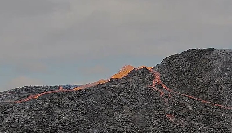
Best view from the https://www.visir.is/sjonvarp/beint camera right now. Lava flows steadily wandering around the shoulder of the cone, with some good airborne torrents.
Fantastic now and then video of the volcano at Fagradallsfjell, for those of you that haven’t seen it:
– https://youtu.be/lEV8fqkcxTA
One really sees the growth…
OH, this is wonderful…. love the music too…. and i seldom like music with my volcano viewing… 😉
Some sort of emergency vehicle took off from Natthagi, all lights flashing, ~12:25. May have picked someone up from the lava front?
Interesting. I backtracked but it didn’t look like anyone was injured. The car stopped only briefly then reversed and drove off.
Probably just police being police: cautioning the lava for proceeding in a southerly direction without an appropriate health and safety permit.
RUV Langihryggur camera https://www.youtube.com/watch?v=BA-9QzIcr3c is zoomed on the cone at 14:20 and shows continuous low-level fountaining in the lake there. It’s rather reminiscent of the fountaining in the twin cones back in March.
New update on flow rate, etc. Still about 12 m^3/s, though possible rates may have increased since Friday. Flows now cover over 3 km^2. http://jardvis.hi.is/eldgos_i_fagradalsfjalli
https://twitter.com/CharlesBalagizi/status/1404455292633600001?s=20
Correction:
The photo is from June 12
La photo est du 12 juin
#Nyiragongo crater by night on June 12, 2021. (Photo by Arsène T. SADIKI).
Cratère du #Nyiragongo vu de nuit le 12 juin, 2021. (Photo by Arsène T. SADIKI)
Its 20 years of built up heat in the crater walls, impressive!
The volcano soure is hot after having souch magma column there.
It coud also be shallow hot magma thats heating the rocks
I have just found this. The changes are spectacular. Can’t talk about how valid this is.
https://twitter.com/SherineFrance/status/1404464516692389888
Yes, that is Nyiragongo after the collapse. Big changes indeed.
Looks just like when Pu’u O’o collapsed in 2011, all the hot lava filling the crater falling down into the conduit and glowing like a colossal blast furnace, just this is way bigger. Would think the lake is pretty well gone though, after such a big intrusion, it could be a while before it returns.
Must be because the floor surrounding the lake was made of overflows, unlike at Kilauea where the conduit formed in existing rock and rarely overflowed so not as easy for heat to diffuse. Also that a lot of the overflows were in the last 2 years, and with there being at least one major vent outside the lake too.
i’ve read Sherine for years…. She’s reliable.
Should we see the current gassing in the cone as a consequence of the tubes not being filled to the top any more?? It started as the flows decreased some.
Karel’s comment got me interested on Nyiragongo. So I’ve checked the last Sentinel 2 images from June 11.
Nyamulagira, the volcano next to Nyiragongo, has drained. In particular it seems that a lava lake, a crusted stagnant lake, had filled up the collapse crater from the 2011-12 eruption and had been overflowing in the past few years. The lava lake seems to have drained at some point during the events of May but has started filling up again, immediately after it drained. In fact it was already filling up while the dike of Nyiragongo was growing under Goma. It clearly didn’t go into the rifting but rather it is more likely that Nyamulagira grew a separate shallow dike that didn’t reach the surface and the lava lake drained into this dike.
Nyiragongo has collapsed. Judging from the timing it’s likely the magma went into the deep dyke under Goma and only a very small fraction of the volume was erupted at the start of the events. The cone is covered in ash due to explosions, probably vulcanian explosions driven by the release of gas from the draining lake and the collapse of rock into it. There is some slight incandescence, but it is very dull, probably just hot rock and gas or some remnants of liquid lava from before the draining. The lava lake is no more and is probably buried under many hundreds of meters of rubble, we will see how long it takes for it to return.
Lava lake at Nyamuragira drained before Nyiragongo did anything, it happened back in early May, and the lake itself was not active since April. Probably not entirely unrelated but not really a direct cause or effect of Nyiragongo either.
Walls are being built to ensure that the lava doesn’t go into Nátthagakrika
https://www.ruv.is/frett/2021/06/14/beina-hraunrennsli-fra-natthagakrika
That’s a courageous digger driver in the picture! The machine looks like it could tumble back down the hill.
The Evolution of “Bob”
https://www.youtube.com/watch?v=EV-UXzRjGzY
A good friend died yesterday. Watching this is very cathartic. That last lingering shot though, with the hair-raising sounds increases the tension as if to say “what next?”
RIP Bob and Bev.
It’s awful losing friends. My sympathies.
I am sorry to hear this
After having circled the sun a few times, I’ve come to think that one of our greatest traits as humans is our ability to take it hard, sometimes very hard, when someone we love dies. That pain is magnificently human.
That said, it has been reported that those elephants which live in herds also exhibit grief.
I’m sorry to hear of your loss, Stars. Hugs.
I went away for a couple of hours and everything has changed again!
Mac
Brillant, thank you.
For the past two hours there’s been oodles of VOG but no visible lava on the MBL.IS close-up camera.
Wondering what the volcano has cooking.
Maybe a stupid tourist is cooking
No change in tremor. Lava is probably directly going into the tubes now.
They are going to build a new wall further south:
https://www.mbl.is/frettir/innlent/2021/06/14/reyna_ad_styra_leid_hraunflaedis/
Loving Chromes attempt to translate this (does get the gist of the article across tho):
The type of route park has been undertaken in the southern most of Geldingadalur and a hedge trimmer that reduces the likelihood of or significantly delaying lava descending into the Nite Field, reports the Public Safety Department.
A decision on the measures was made in consultation with Grindav�kb�r and operations management after lava began to flow from the southernmost part of Geldingadala, across hiking trail A and onwards down to Nighthaga yesterday. Previously, the measures are intended to protect critical infrastructure at Reykjanes and the engineering firm VERK�S will manage the construction for public protection.
“Thisprogression was foreseen than ever before expected. Subsequently, simulations of lava flow from this area were better reviewed. Further lava flows can be calculated and also down to Nigeria, which is an open area in the north, west and south,” the announcement reads.
The construction of the route park will use the same design as the construction of the hedge trimmers built above Nighthaga at the time. The aim is to have him four metres tall to begin with.
According to public defenders, emergency rugby will be started with the current lava stripe to stop further progress. As ever, existing materials will be used in the area. All executions in the field are in such a way that they can be rounded off again and moved to the previous prospect.
It is not clear how long the construction will take, but according to the civil protection information, we can expect it to be several days.
I’m proud to donate my (electric) hedge trimmer to the Icelandic Public Safety Department!
Save the Nite Field! Save Nigeria!
Good to know that rugby scrums can deflect molten lava. Them’s hard working men.
Well the greatest of all Rugby sides is from New Zealand … 😉
Was from New Zealand. 😀😀
Has anyone really been far even as decided to use even go want to do look more like?
What?
Just an update (?) from our Saturday morning trip on a gloriously sunny day, more an interested tourist perspective than a geological one.
Took Route B to the western side of Geldingadalir about 7.30, the only people on that route. All was quiet as we crossed the 427 from the car park (1000kr, pay online) to the start of the trails, where a deserted hamlet of portakabins and containers marked the temporary home of the emergency services and doubtless geologists.
From about 1km from the crater, as we crossed the plain from the car park towards the steep climb and rope, I noticed glistening objects on the ground which I took for maybe the droppings of sheep on a poor diet – they were in fact fragile glassy ejecta from the volcano – perhaps in its spectacular fountaining stage. It would have been “interesting” to be walking there when they were raining from the sky.
Up the hill, up the rope, across a lava/rubble/ejecta field, and there it was. The lava field is YUGE – I was surprised at how much of the Theatre Hill saddle was now covered.
We sat and watched both the volcano and the many helicopters which came and went, depositing the wealthy or fortunate on Theatre Hill, had brunch/coffee, took a trip down to the lava edge with a weather eye open for gas, took a few pieces of crust and admired the liquid but didn’t hang around.
Our guide (who regaled us with tales of the very early days, when there was no route and he and others first walked over very broken lava fields in gathering gloom all the way from the Grindavik (43) road) was very wary of gas, but having studied the growing number of people on Observation Hill and the plume which was rising high despite a strong northerly wind, decided it would be ok, so we traversed south round the side of Geldingadalir, past a lava ‘inlet’ (the lava flows in the channel becoming ever more visible and impressive) and round the foot of the massive lava wall, some 5-6m high, that dammed the lava lake south west of Observation Hill. By now it was 1 pm and Route A was packed with people. It was wonderful to finally see the western and eastern dams, the lava field in Natthagi, with our own eyes.
Up onto Observation Hill, and the best views yet of the eruption. The walled channel down which most lava flows from the cone is oriented SSE, so from Geldingadalir due west of the crater, you only see the top of the lava channel and any overflow or fountaining. From the hill you are looking almost straight up the channel and can see the level of the lava in the crater. Output was not continuous (that we could see), but the bursts every few minutes were very large – on several occasions we could see the lava level was right at the top of the crater, when it would overtop either side of the channel in a huge red waterfall – which seemingly disappeared into the lava field. Often these lava “waterfalls” contained enormous black rocks – presumably removed from the crater walls.
Finally time to head down Route A (hundreds still arriving), with a quick up and down to see Natthagi better, to find police and rescue services (some on quad bikes) everywhere and the deserted hamlet now alive, not with geologists but with coffee stalls and hot dog sellers. Seven hours on the hill, a great day out – and then we found that around midnight the same night, Route A and Observation Hill had been cut off by a fast flow from the lava wall we’d been so impressed by.
Looking at a webcam right now, there is a lot of yellow smoke. Is it yellow because of sulfur, or is it just the evening light? (8:40 pm there, with sunset at midnight. And sunrise at 3 am.)
Just looking, I’d say that’s the sunlight. The predominant colour of both lava field/lake and the crater cone is black, ranging between matt and metallic. The impression when “seen in the flesh” is both powerful and baleful. Any sulphur deposits would stand out a mile.
Later that same afternoon, we visited Krysuvik. There, you can see the sulphur colour from literally miles away.
https://guidetoiceland.is/connect-with-locals/regina/the-colourful-geothermal-area-at-seltun-krysuvik-on-the-reykjanes-peninsula-in-sw-iceland
https://guidetoiceland.imgix.net/383714/x/0/seltun-the-colourful-geothermal-area-at-krysuvik-on-the-reykjanesskagi-peninsula-in-sw-iceland-2
Thank you for the description. I’ve been dying to ask… how do people manage for toilets anywhere in the vicinity of the volcano especially with so many drones flying overhead? 😀 I don’t think I could hold my wee for the time it takes to get there, walk in, spend some time, walk out and then the car ride back to some place with a public loo.
Good question. Didn’t see anyone (else) weeing in the whole trip – but it’s a steep climb plus rough ground which dehydrates you, and you have to carry your own water as there’s none up there. There may have been toilets in the car park or the emergency services park, but I didn’t notice any. I think I went once on the big flattish lava/rock fields at the top of the rope but it was 8 am and Route B was totally deserted. Didn’t go again for 6 hours til we found loos at the Krysuvik (too) hot springs , some 15 miles away.
Route B was pretty empty, vast amounts of space and rocks to hide behind, Route A was like a beach in midsummer as far as crowds were concerned, no privacy there. I’d say far more helicopters than drones as well, plus half the people have long lens cameras. I can only conclude that Icelanders have strong bladders!
Some drone and ground footage, and interview about the new wall construction which is already underway. https://www.ruv.is/frett/2021/06/14/vid-viljum-hafa-stjorn-a-thessu-ef-haegt-er
Great video. Could anyone please provide a transcript or summary of the commentary for non-Icelandic speakers?
They really need to pay more attention to where the berms meet the hillsides to,prevent the lava from going around, which was what did for the experimental barrages.
The accompanying article is a transcript of the video. That’s something RÚV likes to do.
And the new berms are going to be more of a deflecting/guiding berm than a dam like the original two were. With an initial lower work zone berm to protect the workers as before
https://twitter.com/RagnarHeidar/status/1404534755815735298
Some fast moving lava in the most recent stream down to Nátthagi valley!
Meradalir is ever so slowly filling up as well https://en.vedur.is/volcanoes/fagradalsfjall-eruption/real-time-data

It looks like the crater has collapsed in on itself, which may have blocked the volcano. That would explain the lack of fountaining, given that the output is the same. It looks like a lot of degassing going on.
Time will tell what is going on, so much change since I was there last week
I couldn’t get to a timestamp that showed that collapse – won’t go back far enough – and strangely couldn’t find anything written here about it.
Glad someone else saw that!
By the way…large birds or a flock of helicopters on RUV camera @2207, flying behind the cone?
No change to the cone profile as viewed from the Fagradalsfjall RUV cam in the last 12 hours.
Seems main flow is going down the new channel to Natthagi. The channel has doubled in width in the past 9 hours and lava is expanding beyond the dried lakebed toward southern Natthagi.
Fountaining is visible from the RUV webcam “Live from the volcano in Geldingadalir, seen from Langihryggur, Iceland”
Still getting ever more quakes in the magma system at Kilauea, summit and east rift to Mauna Ulu are clearly defined, and the southwest conduit and east rift out to Pu’u O’o are starting to show now too. GPS and tilt still going to the moon.
I give it a few weeks, definitely before the 90 day pause limit anyway.
This isn’t lava there on the right hand side? Most likely just sunlight …
(This is a view from MILA’s cam at Thorbjörn towards Natthagakriki. The pointed mountain should be Stori Hrutur, so the orange spot is at the right place…hm …)
Spot does seem right. If the flow has moved into Natthagakriki, there will be confirmation soon, since it would be quite visible from and threaten to cut off Trail B.
I guess that we can see the lava stream down to Natthagi. That’s indeed possible at two places as the 3D-model shows.
Source: https://sketchfab.com/3d-models/fagradalsfjall-volcanic-eruption-11062021-00a74394dde443d49eef6fc3461f1030
Come on, that’s lava. Here is a 10-minute animation (hope it shows):
Yes, it’s lava; and you can see another spot of lava above and to the left of the one being discussed. Both of those appeared last night around midnight on the Mila timelapses. The upper one is presumably from the south end of North Meradalur.
That is indeed lava, however I don’t think it is flowing into Nathagakriki yet. The camera is ever so slightly “top down” for lack of a better term this early in the morning… So the upper level of lava is where it currently is topping over into Natthagi, and the lower spot is on the inside of the bend in the gully downhill.
They better hurry with the wall on top of the hill though.
Natthagi time lapse 06/14/2021
https://www.youtube.com/watch?v=2SWKuXAgWBA
Wow, those sudden spreads of lava really look dangerous in time-lapse with all the people swarming around. On the flat ground you could find yourself trapped in a really small area quite suddenly if you are not paying attention to what’s happening around you. Hopefully nobody gets trapped there.
Look my video below, fast and lots of it….
I can easily imagine someone taking pictures of lava, sharing them on social media and not noticing that a fast lobe just circled them from behind…
I imagine the heat coming from new directions would be quite intense – but I don’t know if that would be enough of a warning
Here is another very good video with fast advancing Lava……
That splashing is how pseudocraters form, when it happens in a place that there is solid lava of course. Imagine the sight of all those craters at Myvatn as they were forming, like this but 100x bigger.
Someone has been drawing lines in the sand. A shame they weren’t consistent distances apart.
I really enjoyed that.
The vent is happily boiling away Satan’s bath! Makes you wounder what went through ancient people’s mind when they witnessed such events. Here in Australia there has been an oral history handed down to us from volcanic eruptions of not all that long ago in geological time scale.
Yes, Kinrara volcano is only 7000 years old, part of the Undara shield. A few of the craters at Atherton are also young enough to be seen, some are Holocene even just poorly dated. Then there is of course Newer Volcanics which is well known, with probbaly several tens of vents that are young enough to have been seen with the current knowledge of the length of habitation. No doubt at all there are many more such volcanic stories.
All of them are volcanic fields characterised by either small and relatively frequent activity (Newer Volcanics and Atherton) or large scale activity with very lengthy intervals (Nulla). Undara is a shield, though it isnt a central volcano yet. It is sort of inbetween with eruptions about every 10,000 years and 5-30 km3 volume and is probably the most productive overall. That is actually not exceedingly low rate of activity around 2 km3 a millennium at least, just long enough that 200 years isnt enough to make an eruption likely.
Hey Chad thanks! There is still alot of Australians have little knowledge-in my school years nothing was mentioned! It is said after Mt Gambier eruption ended in South Australia that the local aboriginal people use to sleep on the warm earth as it took yersa for it to cool down.
Nátthagi a few moments ago:
Sources: https://www.youtube.com/watch?v=BA-9QzIcr3c. and https://www.youtube.com/watch?v=XwN-u4Ccygs
Guess the walk from the car park is now a lot shorter 🙂
Earth works are underway! Can anyone tell where and what is their plan? Thanks.
Trying to delay lava reaching Natthagakriki?
It’s to keep the lava in its current path, flowing into Nátthagi, rather than letting it spill over the flattish land at the top of the gully, and down westwards into the flat lands beyond, leading to Svartsengi, the Blue Pool and beyond to Grindavik. Much easier to control it at source, keeping it diverted away from large, flat areas of land.
Hope they’re paid well! The bulldozers seem a little optimistic.
Source: https://www.youtube.com/watch?v=BA-9QzIcr3c
Round about the cauldron go;
In the fiery lava throw.
Toad, that under cold stone
Days and nights hast thirty one
Swelter’d venom sleeping got,
Boil thou first i’ the charmed pot.
Double, double toil and trouble;
Fire burn and cauldron bubble.
Fillet of a fenny snake,
In the cauldron boil and bake;
Eye of newt, and toe of frog,
Wool of bat, and tongue of dog,
MBL camera, and blind-worm’s sting,
Lizard’s leg, and tourist skin,
For a charm of powerful trouble,
Like a hell-broth boil and bubble.
Double, double toil and trouble;
Fire burn and cauldron bubble.
Love it. 😀 😀
Aah, the Scottish play. Now, who are the three witches?
They have to be female, I’m ‘fraid (..mumbles..) it’s tradition. Any volunteers?
I’m the second of three sisters lol
Nice one, Albert.
Sorry to be pedantic but I’m not sure your recipe is possible. Are there lizards in Iceland? Never seen one, and am pretty sure there aren’t any. How about “Copper’s hat”, “Fulmar’s gob”, or “Troller’s phone”?
Scale of dragon, tooth of wolf,
Witches’ mummy, maw and gulf
Of the ravin’d salt-sea shark;
Root of hemlock digg’d i’ the dark;
Liver of the VC sheep;
Gall of goat on lava’s heap
Silver’d in the moon’s eclipse;
dutchinsense’s apocalypse;
Finger from the troller’s phone
obscuring the erupting cone
Ditch-recover’d by a drab,
Make the gruel thick and slab:
Add thereto a fox’s chaudron,
For the ingredients of our cauldron.
Double, double toil and trouble;
Fire burn and cauldron bubble.
“Cooking on gas” – as they say. Brilliant. Time to get my cauldron out of the dungeon.
Talking of dutchinonsense, has anyone seen the Hertfordshire Allotment Life’s YouTube channel recently? It bears a more than passing resemblance to our not so beloved pseudopeddler of volcano nonsense. It also appears to have commenced volcanics around the Facebook ban time.
The volume looks very large just in front of the bulldozers and down in Natthagi so maybe they have left it too late or the volume arriving will overwhelm them. Hard to see as the land drops away behind the lava in the foreground but looks to be a tight race from the camera angle.
Which is remarkable when you consider that there is f*ck all happening at the vent, for hours now. Copious outpourings of vog but no lava movement.
Where is all the Nátthagi lava coming from, then?
Its flowing in hidden lava tubes now feeding the flow fronts
I have to say I am surprised they didn’t start several days ago, after all the cost of a few 1000 euros (or whatever) a day max isn’t that much for a country.
Also I zoomed back on the lavafield/webcam page
https://www.google.com/maps/d/viewer?mid=1e4waWgJKj0cujWRkQyX838qk7t3HblU1&ll=63.882065153556454%2C-21.821423318120104&z=10&fbclid=IwAR3LOHnVEPdiUrJVZggmXMEwOIklD0H9VL_d-MMjHcLYLMZ2ZWEYF_iOngM&entry=yt
and noticed its easy to see a truly massive area of lava to the north which by its colour is all one flow.
Well, you shouldn’t compare to a country; the Icelandic population is not much greater than the city of Wollongong, Australia 🙂
For that, in fact, the number of helicopters is quite stunning (at least one had an Austrian registration though).
It may well be down to administrative delays; this was part of the problem when they tried to do earthworks in Geldingadalir valley itself.
Quick Mars update.
Perseverance just spent the last couple of days only 35 metres from Ingenuity and there is speculation that might indicate new flight software being uploaded. A JPL twitter response (later deleted) apparently suggested the navcam timing glitch was due to some interaction with the colour camera and the colour camera doesn’t seem to have been used on flight 7 which would fit with that.
Perseverance has now driven ahead of Ingenuity so hopefully another flight soon, once minimum separation distance is reached.
https://twitter.com/65dbNoise/status/1404748098652577801
Still creeping forward in Natthagi. They may have to move the camera soon if we want to see the front
I think that may take a while. As far as I can see the lava has a small hill to climb (something like 10-15 meters) before it can take the fast descent towards the sea. That means that Natthagi has to be filled up first.
No it goes around it. How do you think rain water leaves Natthagi? The trail to the left is following the lowest path out of the valley. They should hurry to put a wall there as well. That one may stand for quite some time if they make it 8 meters high… 😉
I may be mistaken, but according to me Natthagi is just like Meradalir: a depression surrounded by higher ground. I checked with Google Earth: the former dry lake there (now covered in lava) is at 60 meters above sea level. When I follow the trail towards the sea, the altitude rises to about 75 metera a.s.l. There is no fast exit, it will take a while.
This 3D picture leads you to the lava path out of Natthagi:
– https://sketchfab.com/3d-models/fagradalsfjall-volcanic-eruption-11062021-00a74394dde443d49eef6fc3461f1030
Rainwater does not leave Natthagi. Like with Geldingadalir and Meradalir, it flows to a mudflat in the middle and evaporates. The elevation maps show the exit is 10+ meters higher. Also visible on the 3-D if looking from a really low angle.
Visible in a video from Yesterday, it has still a bit to climb. Yet again, the flow has grown significantly in a day. Still there is a bit to climb. It’ll probably flow back north first before it goes south again.
https://youtu.be/-gWdn2fEtjY?t=138
Also a contour map which shows it, not sure about the contour spacing though
Other maps shows a very small climb.
Water is only to some extent evaporating. Most of it is likely leaving through the gravel underground (under the trail).
I agree with those who are saying there is no rainwater channel out of Nátthagi: the ground is very porous, and the clay pan deals (dealt!) with the rest.
Calculating on the basis of the (10m) contours on the Iskort.is map here https://maps.acme.to/gos/index.php, the most likely route for lava out of Nátthagi is to the SE, behind the MBL cam, into Drykkjarsteinsdalur. It’s not impossible that some could run to the SW, but there’s only a very narrow shelf for it to run on, so all the other exits would have to be blocked for it to run in that direction.
In the long run (if the lava continues to flow in this direction and the levee near the old path holds), it looks like the Suðurstandsvegur will be blocked but only for a small distance, though possibly to a considerable height.
Looking at:
– https://www.youtube.com/watch?v=BA-9QzIcr3c (17:40 today)
– http://vefsja.iskort.is/ (more detailed elevation curves)
– https://www.google.com/maps/@63.8600626,-22.3111995,3a,22.1y,83.44h,89.79t/data=!3m6!1e1!3m4!1sBX8cPSnqsl0PXl0DA_rLfQ!2e0!7i13312!8i6656 (street view towards Natthagi)
– etc
There is a small elevation, the question is: How much?
The 60m elevation curve is already filled with lava. The 70m elevation is a bit up on the sides of the trail. I would say at most 3m, but likely more like 1.5m, perhaps even less.
@67doug, what was your view on this when you were there? You have the answer…
Thanks for those links. I’d looked at the down-valley webcam images but I don’t think they show the exit, so they are inconclusive. I also found the Streetview image inconclusive, but perhaps I wasn’t looking at it properly.
The contours on the Iskort map seem to me to show two things that are relevant: (1) Natthagi is in a slight depression. The clay pan is at ca. 50m and the exit from the valley is at ca. 60m. Overall, that’s quite a volume to fill until the lava overflows.
(2) The shading on the map gives the impression (to me, anyway) that the fall line out of Natthagi is down the slope into the valley to the S and SE, either side of the knoll on the E side of the mouth of the valley. There is a path (green and yellow line) on the slope that drops from Borgarfjall (231m) but that is, as I put it earlier, a shelf on the fall line from the summit. The shelf is between the 70 and the 60m contours, so the lava would have to flow *up* the slope to run along it. I find it hard to see that lava would do that rather than drop to the SE, and even if it did I can’t see that it’d run all the way along it to exit W rather than dribble down the fall line.
I haven’t got sufficiently detailed maps (eg showing 5m contours) to be sure, but my guesstimate is that the lava breach will occur on the 60m contour, one or other side of the knoll.
This is a glacial valley. There’s evidence of a lateral moraine, or possibly a post-glacial fossilised scree slope on the western side of the valley before the gully that the lava used for the third channel into the valley.
The slight elevation rise at the valley mouth could either be a solid rock lip, or a terminal moraine for a stand-still point in the retreating glacier.
I wonder if its possible to get an idea where the lava tubes run with a thermal camera? Would active tubes with hot lava in them radiate a little more heat than their surrounding cooled lava?
Periodic thermal imaging overflights might be a useful addition to the cameras. It might reveal a lot of what is happening beneath the surface.
12.29 on the closeup Geldingadalir webcam, good sized overflow commences and develops into a lavafall into the lava tube maw, and a smaller fall to the right, heading for Meradadalir?
It slows to 12.38ish, then the tap is turned on again.
12.46 there’s an overflow from the centre, heading to all parts at 12.49.
Either the throat got cleared somehow, or a tube got blocked or closed off. So, where is there going to be a pause now? We could tie up which tube-sink leads where soon.
Same Cam: 14:24:30 We can see the exit path. In my eyes doesn´t seem 15 m. height , but sure it is. A part is already done.
It is evident at 14.20 on the Langhiryggur camera that they need to close Natthagi with a wall (a few meters high) today if they want to stop lava from flowing out. That could buy them a few weeks at least..
I am not sure I agree – and nor, I think, do the contours. See my comment above at 15.37.
Icelanders are very resourceful (think of the Vestmannaeyjar harbour), so I think we can be confident that if they can get an earth-mover up to the col near Borgarfjall to head off a possibility that lava will flow W from there, then they’d have had one blocking (the imminent probability of) lava taking the route you propose out of Nátthagi.
My educated guess, having heard the meticulousness with which the experimental berms were designed, constructed, and observed is that a barrier at the Nátthagi exit will only make for a deeper lava lake, and further problems when that overtops the earthwork or finds another low point out.
It’s now reached the point where it needs to climb to escape. Part of it has already started climbing, as confirmed by the current RUV camera view from Langihryggur. The southern exit frm Natthagi is the shallowest slope, so it will depend on whether there is enough pressure to push it forward or whether it will just slowly fill.
Was from New Zealand. 😀😀
Today is the thirtieth anniversary of Mount Pinatubo, and the fifth anniversary of this video:
https://www.usgs.gov/media/videos/pubtalk-92016-remembering-mount-pinatubo-25-years?utm_source=hootsuite&utm_medium=twitter&utm_term=719a1037-ad67-498b-babc-fc14691f20b3&utm_content=usgs&utm_campaign=general-sharing
It is fun to think about this on long timescales. Imagine the hell machine continues at 12 m^3/s for 50-100 years. So 10-40 km^3 total lava. Assuming we know this is what will happen: What would be the best possible outcome that could potentially be engineered?
Unless Reykjavik would benefit extensively from an up to 1000m high shield mountain to the southwest (shielding from storms? Probably would not work well with a low-slope shield volcano), I guess the best would be to bring it all as quickly as possible into the sea.
That would be easiest while the flow is still happening mostly at an elevation below the ridgelines of the existing topology, so that the valleys can be used to direct the flow.
Also, if the cone could be distrracted from growing taller, the backpressure on the vent system will stay low, and new vents will not necessarily pop up in less favourable locations.
The best scenario would be a long-term stable Lava tube all the way to a cliff at the see, and then down into the drink, Hawaii-style. With a dozen cubic km of lava, Iceland could even gain quite a few square km of space 🙂
For that, it seems there are a set of clear requirements: 1) one would need long-term stable tubed flow. This in turn requires 2) a very steady flow rate (variable flow rates and pressure changes will lead to clogging and / or wall collapse), which is probably only achievable by 3) first feeding a large reservoir, and then making sure there is a smooth flow out of that reservoir.
Idealy, one would construct something to regulate the flow rate and the reservoir level (adding and removing sand barriers by excavators with cooled shovels? Shovels of tungsten? Constructing a gigantic, square-meter sized lava valves from zirconium? Ceramics? Grog? 🙂 )
In that case, could envision guiding the lava along a narrow channel straight out of Natthagi (second reservoir after Geldingadalir) to the SW and over the cliff. Ideally a covered channel. Has anyone ever built an artificial lava tube? 🙂 But some kind of narrow, high channel might work by covering itself.
If Icelanders were to pull that off, well, that feat will lead to the birth of whole volumes of novel Sagas to be told for the next centuries, of Icelandic Heroes wrestling with the volcano, and of the Icelanders Who Grew The Island, back in the glorious days of lore ca. 2000-2100 AD, when the elves were ou and about and miracles could still be conjured by mighty heroes 🙂 🙂
I doubt the prospects for strictly controlling th lava flows on land, but once they reach the water I reckon that they should be controllable all Vestmanjar to make a new bigger harbor for Grindavik.
Well, it is so close to the sea now, it would totally be feasible to start pumping water into a pipeline and use that to try and guide lava once it reaches the outflow of Natthagi; of course the height requires beefy pumps (that’s why I predicted rising stocks in pipes at some point, sadly my investment advice so far fell flat, so don’t listen to my financial advice).
However, on really large timescales like the ones discussed here, it is crucial that there is well-controlled flow through a covered conduit for long amounts of time, otherwise the system will always build up higher and higher – and even a very small rate of height increase stacks up over time…
And I am not sure if a stable lava tube will be reliably obtained by just creating walls of cooled lava a la Vestmannaeyjar on both sides of the flow, as those walls will have a much larger and undefined channel cross section between them. But with a very stable flow rate, maybe it is possible as well for the system to lock into one stable channel, establish equilibrium there and then be stable for a long time.
Geoengineering an active volcano, how intriguing!
I really like the idea of ‘encouraging’ the lava to the sea for adding new land.
3 timelapses,
The MBL Close up camera from yesterday between 06h40 – 14h50: https://youtu.be/bD97xSdvxWU
The MBL Nátthagi camera from yesterday and today :
Slow version between 17h45 and 05h00 today: https://youtu.be/IBUAbp_1jCg
Fast version, between 16h30 and noon today: https://youtu.be/AfoFXX9702I
In case the last one plays at a bad resolution, click on the settings on youtube, it should play at 1080p, but youtube seems to have a hiccup.
I’ve got a problem. There was a goddamn power failure here and it seems to have screwed up something in my computer. Since booting it back up, most things are working normally, except for some reason Youtube. It will play for about 40 seconds and then gets stuck buffering. Resource Monitor shows almost zero network activity, so something is blocking the signal. Everything else works, including VC, just not Youtube.
What did the outage screw up and how do I get it working again? Preferably short of reinstalling the browser, or (worse!) creating a new profile and having to reinstall every add-on and manually put all my old settings back the way they were.
It buffers all YouTube content? The buffering thing happens to me from time to time when watching volcano webcams from Iceland, but I never take it personally. Instead I chalk it up to the channel being temporarily over subscribed or the camera being off-line.
Anyway, good luck. Sounds frustrating.
It seems a few reloads and seeks and stuff eventually unclogged the works.
The problem was somewhere between me and YT, as I was getting YT’s buffering graphic. Given that I’d just recovered from a power out, it seems certain that the problem had to be in my computer somewhere, or perhaps the router. Nothing else farther upstream toward YT could have been affected by that.
I would like to know if anyone has any idea what it might have been, so if it happens again I can immediately unclog it without wasting time fumbling around first before finding the right sequence of reload/etc. commands to fix it …
It could be something to do with caching. Normally as you use webpages, parts of the pages ar cached to speed up future visits. It could be that your issues cleared your cache and after a few visits the cached bits were recreated.
Try a simple reboot first and then check your hard disk for errors. Run the command sfc /scannow, If that doesn’t work you can try dism /online /cleanup-image /restorehealth and then run windows update to make sure everything is updated,
https://www.youtube.com/watch?v=ehuO-yyogAA
https://www.youtube.com/watch?v=BA-9QzIcr3c
Webcams: Fagrdalshraun is now flowing in hidden lava tubes
This is becomming just like Surtsey in 1964 – 1966 = a small lava shield is growing with constant effusion
This eruption have potential to last much longer than Surtsey because of larger ammounts of partial melting in Reykjanes moho
Timelapse webcams are working again. Not the last one in nattagi.
I can see some fresh lava today in meradalir but much less than nattagi. Also few building up last days.
What happened to the harmonic tremor? It looks like it stopped.
It did stop, but if you look at the 11:00 am to 11:15 am trace, you can see it trying to get reestablished again. I would really like to know why the geysering occurs for this very hot magma conduit.
See
Where does one find this information? Thank you.
Here: http://hraun.vedur.is/ja/drumplot/
And here: http://hraun.vedur.is/ja/drumplot/drumplot/