There is one question that has been bugging me lately. Why are there two types of eruptions in the Reykjanes Peninsula? Slow and fast. I have talked about this before, in here. Basically eruptions can be classified into two broad categories depending on how fast the maximum eruption rate is, which clusters into two end-members, 10 m3/s and 1000 m3/s. A very significant difference!
The fissure swarms of Brennisteinsfjöll and Tindaskagi produce slow fissure eruptions, which I have also called “wandering eruptions”, because of how I think a certain vent was active for periods of days/months and then the eruption shifted somewhere else, in a way resembling the eruption of Surtsey. The characteristics of these eruptions indicate that the eruption rate was around the boundary of tube-fed and channel-fed eruptions, about 5-10 m3/s. The current Fagradalsfjall/Geldingadalir eruption is of this type.
Reykjanes also has shield volcanoes. Dyngja. This type of eruptions are very voluminous, lasting years, decades, and maybe even centuries. The rate is probably around 5 m3/s or less. They are related to the slow fissures, possibly being just a scaled up version of typical slow fissures or simply a second stage that some of them develop. Some of the dyngja eruptions had multiple vents that each was active for a lengthy period of time, so that they may have been fissures. For example, Hallmundarhraun, the youngest shield, had 4 long-lived vents. Dyngja eruptions also seem more abundant near Brennisteinsfjöll and Tindaskagi. But they show up everywhere too though.

Sandfellshæð, a lava shield of the Reykjanes Peninsula, formed 14,000 years ago. From Google Earth.
The other style is like a flood. A ~1000 m3/s effusion I’d say, by comparing with the similar eruptions of Krafla Volcano. Reykjanes, Krýsuvík, and Hengill fissure swarms practice this particular style. Intense but short. The area around the fissures is briefly submerged into a giant pool of silvery lava, and a long wall of fire shoots 50-200 meters into the sky. The 1000 m3/s peak doesn’t last long though, this could be over in a few hours. It slowly wanes afterwards.
The opposing end members are as different as the day and the night, as different as basalt lava flow eruptions can get. But why?
A matter of structure
I initially thought it could have to do with the primitiveness of the magma, how deep it comes from, and how pristine it is. I started checking magnesium/iron ratios. But no. There was no strong correlation between primitiveness and eruption type. It is true that primitiveness increases towards the west, towards Langjökull, but this seems to be due to the increase in crustal thickness. Eruptions in this whole area come from the MOHO, base of the crust, and the MOHO is deepest at Langjökull. This could give the wrong impression that shields are more primitive because the greatest concentration in the whole of Iceland is in Langjökull. This I saw later. Initially I checked only the area around Hengill and the different eruptions span the same range of primitiveness.
The clue was somewhere else however. It was crystals. Apparently shields may have higher crystal contents. One of them, Lambahraun, has a crystal content of 25-75%, really high. Some of the shields even erupt picrite basalts, like Vatnsheiði, a shield next to Fagradalsfjall. Pricrite is a term used for the highest olivine crystal contents. As far as I know picrite doesn’t happen in the fast fissure eruptions of Reykjanes. It turns out however that there is not too much data on crystal content so I couldn’t really find whether this correlation was really strong or not.
What could crystals mean? A mush. A mixture of molten rock and solid crystals, where the crystals form the greater percentage, is called a crystal mush. And this could explain A LOT. And when things really make sense that is good.

Wikimedia, by Julien.leuthold.
Imagine a wet sponge with water slowly dripping from it. Now imagine the sponge is a crystal mush, the water is the magma, and it is dripping upward because it is driven by buoyancy. You get an slow eruption. Normally this wouldn’t happen because the mush is trapped under the crust, but if a leak has formed, a dike, then you can drip all you haven’t done in hundreds, or thousands of years. The slow fissure eruptions and shields would be feeding from the mush. Magma would need to be slowly extracted from the pores between the crystals.
Fast fissure eruptions would follow the classical model. Magma comes from a magma chamber. This time it is more like popping a water balloon. A chamber is ready to unleash hell because its magma is all placed within the same space that can drain out rapidly when the leak happens. It doesn’t drain entirely, just until pressure drops low enough.
The geochemistry between the two types would not be too different because it is really the same magma. What changes is whether this magma is gathered in one place, or distributed over the sponge,
What are the implications of this idea? It means the magma from the Fagradallsfjall eruption is coming straight from the source. The decompression melt itself. Not stored. Melted and erupted right away. Mid-ocean ridges are underlain by areas of decompression melting. The mantle rises up to form new crust, and because the solidus point is lower at lower pressures, you will get partial melting, and therefore the mush or magma sponge.
The Mid-Ocean Ridge
Why should we favour this idea? An idea based on incomplete data due to the lack of it. First because as much as I’ve tried to look for all possible answers, you do need the magma sponge. The nature of the magma sponge could be many, it could be a mush, or perhaps it could also be a group of thin sill intrusions. But you do need something that releases the magma “drop by drop”, or otherwise you would get the lava flood.
It does match however with the distribution of dyngja eruptions in Iceland. They are found under the mature mid-ocean ridge segments, from Reykjanes to Langjökull, and from Vatnajökull to Tjörnes. They are lacking in the off-rift volcanism like the Snaefellsnes Peninsula. The Eastern Volcanic Zone also lacks them. It is a very young rift, the very powerful volcanoes Hekla, Katla, Torfajökull, Grimsvotn and Bárðarbunga are cutting through the crust like they were slicing through a cake, producing massive, fast fissure eruptions, and creating new Mid-Ocean Ridge, but which it isn’t ripe just yet.

Trölladyngja, a shield volcano formed in one huge eruption. From Wikimedia, Heidi Soosalu.
Shield eruptions are known to have peaked during deglaciation, This makes sense. The deglaciation would have augmented decompression melting in the mantle magma sponge. And who would have been affected? Feeding from the magma sponge the shields would be the first to be benefited from these changes.
The size of an eruption has a reason. For example Holuhraun was so big because the summit of Bardarbunga underwent caldera collapse. The large calderas can feed large eruptions. Fast fissure eruptions of Reykjanes could be limited by the small size of the magma pockets from which they feed and the great depths that makes it impossible for them to collapse. But the magma sponge is almost limitless, so big that each segment runs through half of Iceland and beyond, continuously producing new melt. Shield eruptions can be in fact the largest ones in Iceland, even when they do not come from caldera collapses, they reach up to 50 km3, outperforming even the giant fissure eruptions of the Dead Zone.
Future of the Fagradallsfjall eruption
I still think we are going to see new vents open, even if it takes time. But I have already said this before. So instead. What does it mean to come from a magma sponge? The sponge is big, yes. But Fagradallsfjall still can only tap a certain portion of it, and melt production isn’t as big as it was during deglaciation times. Some say we will get a shield. I’d say a 1 km3 shield would be a realistic possibility. A really big shield like 9 km3 Hallmundarhraun, 25 km3 Skjaldbreiður, or 48 km3 Eríksjokull, seems too much for Reykjanes. This is something that can still happen in Langjökull. But a large shield hasn’t erupted in Reykjanes in over 5000 years, since Brennisteinsfjöll’s Leitahraun. Deglaciation was a while ago.

Skjaldbreidur shield volcano. Wikimedia, from Ingeborg Breitfeld.
A cubic kilometre is also a common size for slow fissure eruptions, probably. The last eruptions of Brennisteinsfjöll and Tindaskagi were about this size. In that case the eruption could last a few years. Good for tourism! Bad for optical fibre cables, I guess.

A magma chamber that can be visited on Iceland, from the Brennisteinsfjöll eruptions 1000 years ago. The image looks up from inside the open volcanic conduit of Thrihnukagigur. A lift use to move people up and down the 120-meter drop is visible in the image. Wikimedia by Dave Bunnell.
We are watching the creation of new ocean crust. Something hard to find anywhere that is not submerged under a few kilometres of water!


.JPG)
That lava flow has pushed so far into the valley, I was only there last week, so crazy how it progresses
How much must it climb to leave the valley? Hard to get a good view on that from cameras and maps.
I think the lava has pretty much filled the lowest part of the valley. There may be some more extension at the far right (where there is another exit to the valley) but overall, any extension of the flow field will need meters (5-10?) of rise. I expect that we will now see slow thickening of the flow. Where the escape will happened depends on where it thickens most. Not easy to predict.
“Thickening” – good point, noted. Thank you.
Tuesday
15.06.2021 19:47:08 64.651 -17.518 3.1 km 2.7 99.0 1.3 km NNE of Bárðarbunga
what are the nearest drumplot and tremor stations to the Icelandic eruption ?
Have a look at this map
https://twitter.com/naspmon/status/1403376825146003467
The three main ones to look at are FAF, MER and ISS.
It’s so poignant to see the lava cover the car tracks. i wonder what we could leave behind as a message to a far away space traveller that we existed……………. what could You cover with lava that would survive to be discovered by the far distant future explorer?
There’s going to be some weird trace elements in the Geldingadalur lava left by kamikaze drones. 🙂
….and sacrificial cameras….
🙂
Dig a big trench and fill it with glitter. In my house that cursed stuff is indestructible.
the car tracks made me think of Back to the Future
[img] [/img]
Going in or coming out??😀
I didn’t see which way they went 🤣
“But .. Won’t I crash into the lava?”
You’re not thinking three dimensionally .. Marty ..
“yeah .. right”
By the time you reach 88 mph the lava won’t even be there ..
No changes in tremor for the last 2 days. Staying at high levels. Station closest to the eruption.
The lava which made it’s way into Natthagi valley was amazingly fluid, even at the front. Either it has become even more liquid than before, or a long lava tube has already been established in the steep slope from Geldingadalir into Natthagi valley.
People should be very cautious when taking photos without keeping an eye on the approaching front.
True….people best be very careful – keep one eye on the lava front(s), and another on escape routes.
Watching one of the videos of the rapidly advancing Natthagi lava, I witnessed locals tossing in plastic bottles.
At this rate, by the time the lava reaches the road it may be carrying a tide of plastic waste, old fridges, bicycles, shopping trolleys, mattresses, the occasional car, some UK waste nuclear power station rods, and redundant computers. Not to mention the odd Icelandic gangster with his feet in concrete.
A useful mobile landfill, perhaps?
Magma Sponge indeed ..
Natthagi timelapse for 06/15/2021
https://youtu.be/LKS5mhGx6i8
You can see the lava flow thickening as well as advancing. Must be an impressive volume flowing into Nátthagi
Attached image shows the past 12 hours increase in extent of flows in Natthagi. Seemingly little change, but comparing to elevation maps, about 5 meter increase in depth. The flow is ~15 m^3/s based on measuring dimensions in Google Maps and calculating volume. None of the cameras show visible flows, so appears that most or all of Nar’s output is flowing directly through 2 miles of lava tubes.
https://imgur.com/a/eRMD8WW
Sorry, or 3 kilometers (from US).
https://youtu.be/qPShqWZCYxM June 15th drone overflight
That was short but informative.
The cone lava pond is larger and constant. Is this a shield now?
The diggers are doing a great job at stalling the lava and keeping it going where they want it.
Road map for lava..
That shows, that if it wasn’t for the wall that is being built, it would have flowed into Natthagakriki.
Hello to the Group.
Thought some might find this research article I found of interest.
https://se.copernicus.org/articles/10/725/2019/
Nice find! Thanks for bringing it here.
It conclusively knocks the “sun affects volcanoes” squad on the head, dead. And good riddance to that nonsense!
But the writers come up with some very interesting results on possible tidal effects on magma gas.
Cool article. (Well, hot, I suppose…:) )
Great job on the retaining walls to divert the lava (or keep it in Natthagi), the diggers must have been going half the night. When the RUV2 camera points at the new walls you can see the road traffic in the distance, a reminder of how close the lava is now to the 427 road.
On Randall’s video link, above, I get the impression the lava would have gone over the edge already, were it not for the new retaining ramps!
Bulldozers don’t look very safe.
At 15.22 (14.22 in Iceland) the bulldozers are raising the “Route A walls” another metre or so. New black material appearing at the right of the picture, occasional glimpses of a dozer blade.
I think the road seen in that angle is actually the 43 road by the Blue Lagoons, unless the fan map is wrong about the camera location (which they acknowledge is iffy for that camera).
I’m sure it’s the 427, as I’ve walked down Route A to it not so long (Saturday 12/6). It’s a longer walk to the 43. Our guide showed us where he set off to find the volcano back in (March?) from near the Blue Lagoon on 43. Said people were walking unequipped (no torches) over really rough old lava fields as darkness was falling. I think some had to be rescued.
he camera labeled “Langihryggur” usually points at the eruption, but sometimes swivels to show the Natthagi lava and sometimes looks at the work on Route A, where it crosses a saddle onto the upper reaches of the Natthagi valley side. At this very moment (22.05 UK time) it’s showing the Natthagi lava. Route A starts on the 427.
https://www.ruv.is/sjonvarp/beint/ruv2
This very excellent map lays it all out. However I disagree with the author about the location of the Langihryggur camera – I think it is indeed north east of where he’s marked it, near the Met Office Langihryggur camera If it was the 43 we were seeing traffic on, I don’t think at that distance you could see much of the vehicles, whereas I can distinguish between cars and trucks/vans on the camera (when it’s pointing at the Route A saddle).
https://www.google.com/maps/d/viewer?mid=1e4waWgJKj0cujWRkQyX838qk7t3HblU1&ll=63.88011268672835%2C-22.333725893511662&z=13&entry=yt
To put it another way, I couldn’t see any 43 traffic at all when I was going up B and coming down A, whereas 427 traffic was easily visible.
Apologies, I believe I am wrong and you are right. The road in the video is straight, whereas the 427 curves near Route A, and the sea is not far away. I must assume the camera operators are zooming in on the saddle where barriers have been raised and that’s what makes the traffic so clear.
Apologies again.
Respect 🙂
Meradalir:
OK, can we please have the vog not blowing directly toward the camera sometime soon? Four days of this is getting old very fast.
Set up some big fans. It totally worked for the Floridians a few years ago to blow Matthew away from the coast 😉
I think they chased Matthew away with firearms. Or no, maybe I’m thinking about Texas. I remember Trump wanted to nuke him.
Have a word with your local Bishop. He (or she) can have a word with him upstairs and get it sorted.
🙂
Just have to ensure He speaks Icelandic.
May need to be able to speak to the Troll Gods.
Hi All,
2 timelapses this time.
A continuation of yesterdays fast timelapse of the Nátthagi camera, starting at noon ending at 10h20 this morning
https://youtu.be/Ulg6qXaxIJY
and a timelapse of the close up camera this morning 5 am to 9 am. I was wondering about the smoke that seems to come out of the right side of the cone (last pasrt of the video). What is it?
https://youtu.be/czmFxKuvxb8
Really good, thanks Virtual. I particularly like the end of the second video, with the channel flowing off to the right emptying. Another pulse off to Meradadalir?
https://www.youtube.com/watch?v=BA-9QzIcr3c
https://www.youtube.com/watch?v=ehuO-yyogAA
webcams
Looooots of volcanic smog now from the spatter cone lava lake… lots of of degassing
Lava is entering a tube system at the edge of the lava lake where it flows down into the earth.
Lava emerges in the valley below and in the lava plains around it. The pahoehoe close to the Fagradalshraun are very very fluid. We are seeing the birth of a small lava shield
Seems like it was not posted yet: Finally the met office answered the pleas, there is a fresh timelapse of the Meradalir cam of inflow into the valley. The flow apparently has just restarted today, maybe Natthagi influx will stop or be reduced.
Thank you. It seems to be filling up nicely and has plenty of room for more lava, which means less pressure on Natthagi.
No no. This vid is from end May! Please look at the time stamp.
Taking back the comment. Starting in may. Ending in june. 🤐
However, there is nothing visible in Meradalir. The increase in Natthagi seems a good bit less than yesterday. Not sure where it is going, may just be day to day flux in Nar’s output.
There is new lava in meradalir. Visible now. This morning was moving. Not huge, not tiny.
Nattagi last 12 hours maybe less than yesterday but all surface is going up.
The Natthagi flow is also still widening
This really shows how much lava that has gone in this direction. Perhaps 30 meters higher in a few weeks close to the crater (or more, the valley floor was originally located 100m lower than the valleys that the lava comes from). Soon it can’t be called “dalir” (valley) any more.
The decrease in the slope makes lava flow slower and that is likely what pushes lava over to Natthagi instead.
I looked a bit at the elevation maps and it seems that the outlet from Meradalir is close to be reached by the height of the lava. It is however not visible in coverage area of the camera.
It s however very flat on the other side towards Sandfell, this implies that it will only slowly expand in the southern direction there and that most of Meradalir must be filled up for it to reach even close to the road.
Lava will most likely reach the southern road much faster via Natthagi even if it would be enclosed by a wall or two.
But it is interesting to speculate how much the lava must grow in height before it can pass different obstacles.
The wall built to stop lava going into Nátthagakriki is only the height of a person, c. 6′, (there were 2 standing on it yesterday) above the lava. It wouldn’t take a lot for that to be breached
True. I am also wondering whether it is on downward slope. But it has the advantage that the lava has somewhere to go. it is a diversion rather than a block. I had understood that the plan was to build a bigger dam behind it with the current one acting as a safeguard. Is that still happening?
Don’t know; not based in Iceland. Perhaps others here can shed light on it.
It’s pretty steep on that slope, so I’m not sure how easy it would be to build another wall behind.
Seeing the image below from just above the carpark, indicates there is more room behind the wall than I thought.
This drone video starting at 40 seconds in shows the new berm
and general lay of the land
In this video, the lava channel on the extreme right (or northeast) is cutting down into the lava bed, and is almost disappearing from view. It’s almost certainly going to become a lava tube, and provide a constant drain to the lava lake above. This will help keep the pressure off the diversionary berm above.
GeologyHub just posted an interesting video about a volcano on the San Andreas fault, that I never knew existed, on the shore of the Salton Sea. This has erupted in the last 2000 years.
There are a lot of earthquake swarms in that area, I had always assumed all tectonic. Makes you wonder, though.
USGS has stated that these swarms are not volcanic. The Salton Sea is a rift and this can allow for volcanic activity. But these swarms seem fault-related.
Correct. However, it is interesting to note this latest swarm was in the same localized zone as a similar swarm (100’s of quakes) in 2016. It has been suggested that the Salton Sea is the southern terminus of the San Andreas, but that needs further research. Regardless, the Salton Volcanic/Geothermal zone is rather high on the USGS watch list for future activity, with the last eruption only 1,800 ya.
Any ideas how an apparent rift zone volcano can be high silica/rhyolitic?
Let the magma stew long enough and anything can happen
https://www.youtube.com/watch?v=ULbuPLm6eNU
And Etna try to get some attention sending up some smoke signals at daytime for a change..
Nice little swarm south of Langjökull, close to the Geysir area. Irpsitdyngja in the making?
Most in the crust with a few fairly deep ones, 13km -14km.
The Langihryggur camera was trained on the Route A “saddle barrier” a moment ago, steam rising from the top of the barrier. Slightly ominous.
(Anthony Scalzi was right when he said the road in the background was the 43 not the 427 on saddle shots. Must be zooming in a lot)
Most likely just humidity in the soil that’s been piled up, which is now evaporating off as the soil is being heated through.
The lava pool level in Natthagi is now at the 60 meters above sea level mark on the elevation map. In the past 48 hours has risen about 11 meters (started slightly short of 50m mark) and maybe 5 meters remain at a guess, so on track to overflow tomorrow afternoon
Natthagi is comparatively narrow and fills quickly, so not much point damming. If they built an 8-meter wall at the exit, that would only hold two days, assuming the flow did not decide to shift to Meradalir meanwhile.
I would say rather say that 8m saves somewhere between one and two weeks as the lava needs to fill the valley towards the old inflows as well (that have a few degrees of tilting towards the sea). The last 48h have not filled much in that direction. But that might not be worth the effort anyway.
Good point, though the depth during this period has increased even at the claypan, so the area needed raised would only increase 50% or so. Not worth the effort unless that buys time for the flow to shift to Meradalir. Might keep flowing this way for a while though. Since it is mainly traveling through insulated, constrained lava tubes, that reduces the buildup in the channel that causes the shifts.
Note also that the slopes to the sides are drastically increasing the volume of the valley as the lava is filling it up. I made a very simple model that indicates that the next ten meters will take at least 3x as the previous 10m (measured in time) due to this slope. It is very easy to forget this aspect.
Any barrier across Natthagi would only allow lava to pile up behind. Once the dam was overtopped, downward erosion would release an enormous amount of lava, possibly in one enormous rush. Much better to let it find it’s own way down to the sea, then make sure it’s well channelised to prevent it spilling over elsewhere.
I think they will be ok. Two big cars are blocking the path
Hope they pulled the handbrake.
Not advocating using the lava fields as a garbage dump…but….using squished cars would take more junk out of the landfills/less to ship out of the country, and would help make a berm as well. Might make a mess when the berms get heated up, though….more toxic fumes. So probably best to take a pass on this.
Perhaps using old tarmacadam from roads and broken up concrete would be a better idea for this task…not for the immediate rush to build the diversion berms up top, of course.
Or the skulls of your enemies (but they are better used to drink from, no?).
🙂
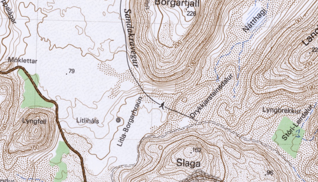
I’ve managed to find a fairly recent 1:25k map of Natthagi. It has 5m contours which are not always easy to read, but I think it tells a clear story. I’ll try to describe it in words, but if someone can describe how to upload a screenshot, I’ll do that.
The clay pan is shown as being at between 45 and 50m. The highest contour on the rim of the shallow bowl that forms the valley is 60m. Two ephemeral streams are shown flowing out of the valley, one either side of the knoll on which the camera is located (on the E side of the valley), both flow south into Drykkjarsteinsdalur which, contrary to my earlier view, is predominantly W facing owing to a spur dropping into it from the E. There are no contours for the stream beds so they must be very shallow.
On the W side of the valley – where the vehicles are entering, and where the slope out of the bowl may be at its shallowest, the SE-facing slope of Borgarfjall is intersected by a shallow valley (not, as I’d earlier thought, a shelf), ca. 200m long, between the main slope of Borgarfjall and an adjacent ridge – 15-20m high – to the SE.
Which way will the lava exit? As Albert has pointed out, much will depend on how and where the lava thickens. But I have changed my mind (apologies to those I disagreed with earlier), I think that whatever route the lava takes out of the Natthagi bowl, it’ll end up flowing west and will add another layer to Litla-Borgarhraun, meeting the Suderstrandsvegur (if it gets that far) SSE of Lyngfell. Whether it’ll block the road is another matter: recently built Icelandic roads (which this one is) are often elevated above the surrounding landscape to prevent drifting snow from blocking them.
Pictures save a thousand words! The tweet linked to by 67Doug at 17.24 makes everythig so clear! (Though some of the E exit from Natthagi is hard to make out.)
OK, here’s a screenprint of the relevant bit of the map (if I’ve done the right thing with imgur!)

Or perhaps not! I’ll have another attempt later via Hugh Mann’s link.
I have put your map on here for now.
https://www.volcanocafe.org/wp-content/uploads/2021/06/Natthagi.jpeg
Many thanks for your help, Albert. If this works, please would you de-clutter the thread by deleting my earlier posts relating to my attempts.
Here’s another attempt via postimage to post the screenshot:
For anyone who’s interested, the map was downloaded as a TIFF from here: https://www.lmi.is/is/landupplysingar/gagnagrunnar/nidurhal
Awesome find. I love a good detailed map. I’ve been occasionally looking for such a map without success.
Now drumming my fingers awaiting the download…
I was told that there were some glacial moraines in Natthagi. It’s a bit tricky trying to analyse the geomorphology from afar, but looking at the map extract the entrance does look like a rock lip, with a couple of dry valleys which haven’t cut right down to base level; hence the ephemeral lake formation in the enclosed part. If the higher ridge isn’t solid rock, it will be some sort of stand-still moraine deposit as the glacier tongue wasted away at the end of the last glacial period.
I really need a good text to make sense of the differing interpretations of the surface landscape here. Soil erosion due to over grazing, or excess precipitation, or periglacial stone shifting; I’ve heard lots of passing references but no detailed descriptions of just how the surface came to be.
I really need to see more of the area towards the sea to have a stab at where the lava could possibly go.
And of course as I keep on saying, so much depends on the microtopography, and other ephemeral factors as to how the lava will behave when it finally gets near the road.
It’s great, isn’t it; glad you like it too. I am still astonished at my incompetent earlier reading of it.
The Isor geological map (http://jardfraedikort.is/?coordinate=63.87%2C-22.32&zoom=9) has Natthagi as “undefined surface deposits”, and the low hill with the camera on it (down which the shallow gullies flow) as “interglacial shield lava”. Apart from one small ridge which I interpreted as water-borne gravel, I didn’t see anything that looks like a moraine in the excellent video that Triffin posted, but they could now have been covered by lava – though they’d be more likely to be at the exit of the valley, wouldn’t they?
That is what I found from the displacements along the Reykjanes fault: this area has an age that is consistent with the previous interglacial, roughly 100,000 years ago. And now we finally see the region remodeled. Our luck. The valley looks more like water deposits to me (flash floods bringing muck from the hills to a lake). There may be some glacial deposits (including that big rock that was covered some days ago) but ice age moraines would be further out, on what is now the sea bed, I expect.
I was told on Facebook that the bare area just south of the new lava stream gully was a lateral moraine. Again, impossible to tell remotely, but it looks more like post-glacial scree to me.
The ‘interglacial shield lava’ makes perfect sense, albeit very frustrating in its nonspecific description. Probably a blanket generic term for anything not properly investigated!
That lovely slow drone video is great. I’m going to have to watch it several times.
The area outside Nátthagi looks a bit hummocky, with a few depressions. Lots of potential microtopography.
In my natural element here, maps and a landscape to analyse, what’s not to love?
Natthagi focused drone footage ..
Great vid. Thanks for posting. Shows how wrong my earlier map reading was !
First upload the image to a hosting site. I have been using imgur this time around, but during Bardabunga, I used Flickr. Others have suggested other (better) alternatives. If you upload to imgur, right click on the image and use the copy image link option, Paste that link into a reply box (make sure it ends in .jpg.) and it will embed, Otherwise you can post a link which takes you back to the image.
Many thanks. Might have a go later, but 67Doug’s photo Tweet is pretty good.
I didn’t link directly to the map because it is a ca. 700Mb TIFF downloaded from the principal Icelandic mapping website and I’m not sure everyone would want it to occupy so much disk space!
https://postimages.org/ is pretty good. Free and you don’t have to register.
Just looking at the cameras and see my first lava over the edge of the vent in days.
Mac
Certainly has been in steady-state lava lake mode for a while now, he said, stifling a yawn.
Iceland: interesting little swarm of seismic activity under Rauðafell. Between 5-9km down.
The nearest drumplot station (Gygjarholskot) shows rock-cracking quakes (to my untrained eye).
This one is a little outside of the usual suspects!
There are EQs from time to time in that area, but this is the biggest I can recall.
a bit delayed comment to what angered Carl at the original Nyiragongo eruption. So many things are wrong.
https://www.sciencemag.org/news/2021/06/european-data-monopoly-hurt-forecasts-deadly-eruption-congolese-researchers-charge
https://twitter.com/JMEsole/status/1405186355446128640?s=20
Mostly fair comments. VDAP is a brilliant program, worth every penny. The funding crisis at GVO was locally made though, and the data access was broken because of the lack of local internet. That cannot be put on the door of the europeans. The attitude it describes about collaboration with the GVO though sounds very familiar from my experience with research collaborations. It forgets that volcano observatories are not just research appendices. They have a task to do
Has anyone yet got a good model that explains the shifts between gas pistoning and steady state effusion at the vent?
Yes – but haven’t checked yet whether it works ..
Nice map showing the area from the carpark and up the valley to the main crater
https://mobile.twitter.com/ICTBloke/status/1405269952878178305?fbclid=IwAR3udO1s2_PNndh6w01lrm4ubAtqPap8oUDZuPUMPlXP6OJRSWr2AXoWbFA
It’s wonderful how the simplest of photos and well done drone flight videos (thanks again, by the way, for your work) can put things into perspective.
Yes, it’s a good job being done on the diversion plan, because the lava getting into the other valley indeed looks like a horrendous goat show would be the result.
‘The Taming of the Flow’ (“Shrew”dly)
🙂
Great pic. Thanks for posting.
Seeing that makes me wonder whether insurance on rental vehicles in the car park would cover lava damage :P.
Depends on how you make the claim. I recommend ‘Lost the car. Can’t find it anywhere. Parked it, paid for parking, came back, parking place nowhere to be found. A bit of new paving but no car park.’
It does remind me of some certain insurance adverts.
Happy Icelandic National Day to all you Icelanders out there.
Here’s a 1:25k map of the relevant area. To save people counting, contours are at 5m intervals, and there are two kinds of index contour: thick ones are 100m apart, thin ones 20m. The grid is 1km, I think.
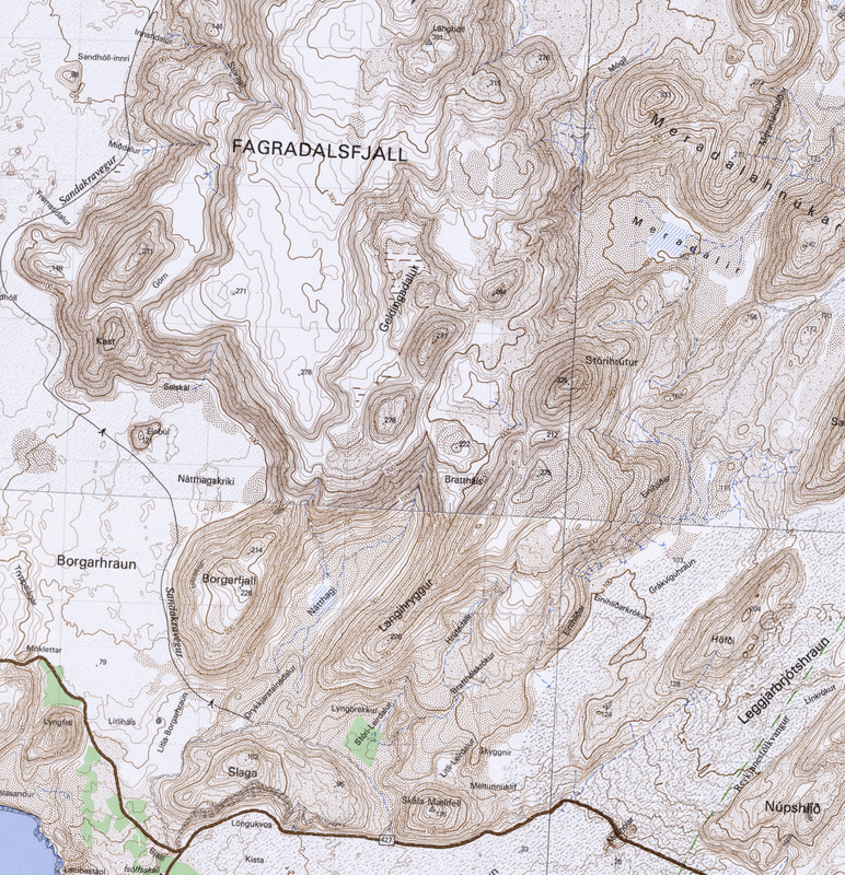
Looking at that, the third flow going into Natthagi, from the southwestern exit of Geldingadalur, is within 5 metres of flowing into Natthagakriki and coupled with the image posted the other day, looks as if it was only the wall that stopped it from doing so. It’s difficult to judge the distance from one side of the small plateau on top of the ridge to the other as it flows out, to know how much room there is to build a second wall, as it isn’t really possible to measure on a monitor and know if it is the same scale. Also, the lava probably needs to rise 5-10 metres to escape Natthagi.
It looks like they have less than 200 metres to play with when building a second wall, judging by the Kortasja map.
Did you stitch that together from the 4 maps I spent an hour hunting and downloading at 1 am this morning!?
I learned a few new Icelandic words!
Well done!
No! – I wouldn’t have gone to that much trouble to prove that I had misread the contours! I just downloaded it as one sheet, already stitched together, via the website I linked to.
Anyway, respect to Icelandic cartographers for making decent sense of what can be an extremely complex landscape, and for enabling our armchair explorations. I just wish they’d put in a few more spot heights!
Can’t see any comments on this, so apologies if missed.
IMO have added webcams to site
https://en.vedur.is/volcanoes/fagradalsfjall-eruption/real-time-data/#teg=s
Thank’s! I didn’t know…
Nice link! There are also some drumplots and GPS figures.
Small cluster of earthquakes on Kilauea south flank, south of Pu’u O’o. Will be interesting to see if the conduit to Pu’u O’o or even further east is activated following this now, there hasnt been much activity on the south flank for a while.
I refer to the map most recently sent by am57 here above:
The lava has now reached the pass between Borgarfjall end the small ridge separating it from Drinkstone Valley (Drykkjarsteinsdalur).
It might seem prudent to build a dam in the pass to better fill the Nátthagi tub.
Unfortunately the Drinkstone will probably be lost unless one of the diggers moves it. The stone has been known for centuries as an ‘endless’ source of water in an otherwise very dry area. The stone is said to have been blessed by legendary bishop Guðmundur góði (the good), born 1161. https://ferlir.is/drykkjarsteinn-saga-i/
Once the lava gets out of Nátthagi it’s not looking good for the old homestead Ísólfsskáli. Home of the settler Viking Ísólf who was said to have been buried where his geldings liked to graze. In a valley called Geldingadalir.
That’s very interesting and a little bit sad, too – really brings the landscape to life.
How big is the Drinkstone? Would it be possible to protect it with large concrete pipes (as used for culverts etc) laid vertically to form a cylinder? After all, once lava is out in the plain and moving towards the sea, it may not be that thick.
I didn’t know it was there, would have been interesting to visit.
Only way to save the stone is to move it which is probably impossible.
Gutn Tog made a couple of videos explaining the Drinking Stone. It’s hard to tell if it’s an erratic, or part of the solid geology. Difficult to move, expensive, yes; but not impossible.
But if moved it would presumably no longer work, or does it work simply by trapping rainwater? Is it fed from beneath?
Now, that’s the $64,000 question.
My impression from the link is that it’s hyaloclastite, heavily wind-eroded so that it traps a lot of rainwater.
It’s not like the areas of the Reykjanes peninsula without running water are in the middle of the Sahara: rainfall would be sufficient to keep cavities in the stone topped up. (Perhaps the stone itself is an erratic…) I’ve checked a map that shows springs, etc and it doesn’t look like there’s one there. But maybe the Good Bishop knew something we don’t. A welcome drinking source all the same.
What about just burying it in a protective cover of heaped up earth and re-excavating it once this is over? Seeing how the lava interacted with the earth barriers that might work?
Because if this lasts a while it will be buried in a few tens to maybe even a few hundred meters of lava…
Attached image shows increase in Natthagi since the fan map was updated. Red spots are where the flow edge is matched between the video and the map, pink lines are extrapolations, yellow line is estimate of exit elevation line. https://imgur.com/a/OO5a7N0
Flow is 1/3rd of the way from 60m line to 65m on the elevation map. Exit is less than 65m, so 2 or 3 meters to go. The increase has been slowing, since the area needed filled keeps increasing, in large part probably in northern Natthagi. Lava flow will also need some thickness above the exit to flow past, so may be couple days away. Rough calculation based on area and increase in depth suggests flow into Natthagi is currently 10m^3 per second or a little more.
Would seem either the effusion rate is higher or nearly all the lava is going into geldingadalir and from there into natthagi, if it is at that sort of rate.
Think it is the latter, rather than the former. Flowing through tubes, so little lost going to Natthagi. Since the new flow into Natthagi started 5 days ago, almost nothing has been happening elsewhere: a tiny amount to Meradalir and some more accumulation on the cone itself.
Latest videos from Natthagi show pahoehoe at the flow front (generally inconsistent with effusion rates that high – but the lava field now has a wide flow front, too). You could be right, but my impression today has been a markedly decreased flow into Natthagi and the pahoehoe tends to support this. Remembering that A’a to pahoehoe is a rarely seen transition suggests slower flow rates up the hill, also. That said, I’m probably way out in left field on this.
It is pahoehoe because it isnt actually flowing at all technically, its inflating in the valley and rising up the walls with little breakouts at the edges but more like a rising lake than an advancing river. It seems there are actually conditions where lava tubes and pahoehoe fields can form in eruptions that have an eruption rate a lot higher than 5 m3/s, it is more if the flow locally has a flow rate of that magnitude, and also if it flows fast. It is a pretty bad misconception that a’a is slow and pahoehoe is fast, a’a flows are way faster.
It is also known that the lava will stay pahoehoe if it is confined regardless of the eruption rate, even in cases an early a’a flow will remelt into a smooth surface if it fills a depression. The eruption at Kilauea back in December was very powerful, probably one of the biggest summit eruptions there we have on recent record, flow rates of 250 m3/s or more in those early days and mostly from a single vent no less, but a’a never formed anywhere despite this.
Thats because the rootless lava lake is a big hot mass and that keeps the surface skinn smooth
Thanks for an informative and interesting reply, Chad! Now I know a lot more about Pahoehoe and A’a variations.
That would be be about 2 meters of thickening a day, and escape out of the valley in 2-3 days. Are you sure about the rate?
It has been thickening at that rate. It is slowing as each metre requires more volume. It gained 4m in 12 hours after covering the flat area, and now is gaining 2 meters a day. Almost all the lava is going here.
I take periodic screenshots of the flows. This shows the increase over the last 3 days with tour bus for scale: https://imgur.com/a/sNBmHOh. Looking at the topography maps (which are quite good, the lava ends up exactly where it should), the flow has risen 12 or so meters since then.
Pahala going 4.5
never understood if there is any impact down / up the line later.
Lots of different ideas out there about how lava will exit Natthagi. This Gutn Tog youtube puts the viewer right where it matters – nicely allows us to see virtually first–hand the slopes and distances involved.
https://www.youtube.com/watch?v=hwm8YGJ2lAc
Camera lens appears to be set at 40 – 60mm, generally a normal view without excessive perspective error. It sure looks like the elevation gain required for exit is well beyond 5 or even 10m, and that substantial expansion of the entire souther Natthagi flow field will have to occur. I think it’s gonna take a while, like on the order of weeks. YMMV, that’s OK!
Much can be gleaned from topo maps, 3D models, and the like but there’s no substitute for being there. This video comes as close as I think anything can to that for the purpose of evaluating exit timing.
Who’s gonna invite this guy to join us once in a while?
Looks like as soon as it crests the hill it is going to flow into the ocean very fast, with that sort of flow rate it will move as a pahoehoe sheet flow, or maybe a fluid a’a flow, like the one that took out the western dam the other week. Seeing that go into the ocean will be quite a sight.
He said previously that he is using his wife’s phone and it does look quite distorted as he turns. I would estimate closer to 30mm focal length, but he is also zooming in and out. The standard focal length for a Galaxy S10 is 26mm and I believe he said it was a Samsung, although I can’t remember which.
Nice swarm of quakes in Hawaii, mostly aftershocks of the 4.5 at Pahala but theres also quite a few around Kilauea summit today, including one at 6 km depth directly under Halemaumau, and another at 13 km depth at the south caldera. That is the depth and location where it can only be magma movement, and that is what it looks like on the seismometers too…
Mauna Loa is also dead quiet too, seems any suspicions of it taking over from Kilauea after 2018 are quite in doubt now.
There are 501 felt reports on USGS for the 4.5
And some actual reports at https://www.emsc-csem.org/Earthquake/earthquake.php?id=999822#testimonies
More at link above
I have always had a bit of a feeling that the quakes down there are much more powerful than the magnitude suggests. The rock is solid, but it is probably still much hotter and more ductile than a typical patch of crust, making it crack is not going to be as easy. A 4.5 that lasts for over 2 minutes and shakes the ground around is not really a common thing, especially one so deep inside an active volcano.
It is a shame we dont yet have a true idea of what this quake swarm means, it involves magma but how it connects anywhere is still mysterious. Whatever it is though it is much more powerful than it was a few years ago, it is rather ominous, I get the feeling that Kilauea is going to get supercharged by it in the near future, which is really something when you consider it is already dominant of the hotspot.
I dont think it is wise to assume Kilauea cant erupt a really big fissure eruption just because we havent seen it, something of a really massive scale. A 1 km height difference was apparently enough for Grimsvotn to create Laki…
Can anyone tell me about this? Urup Island. It looks like a plug.
https://www.instagram.com/p/CQObk-uLssm/?utm_medium=copy_link
Hope the link works.
Once again news relatedto the still cams.
ACME website has put up the possibility to watch a slideshows of the stillcams (meradalir, we miss so much 😉).
Like the old IMO site, just a somewhat lower resolution I guess.
https://maps.acme.to/gos/#webcam_still
The still cams are actually back, e.g. Meradalir http://brunnur.vedur.is/myndir/listi/webcam_meradalahnukurSSV.html
*dances happy dance* YES!!
Does anyone know if there is any digging activity going on at the exit of Natthagi? If nothing is done, I would expect the lava to exit Natthagi through both exits, SW (towards Lyngfell) and E (spilling into northeastern Ögmundarhraun); making the Slaga mountain an island. SW first, East a a long while later Probably the E exit is easier to block, because it is slightly higher (but much wider), and the crest is further back.
But more importantly, when it does exit west towards Lyngfell, it seems it will quickly curve south and then east, according to the contour lines, basically flowing to the road and then along to road, unless they will actively barricade the lava above Isolfskali to make it go directly to the sea rather than past Isolfskali to the western part of Ögmundarhraun. I wonder if they will try to influnce the flow to keep the covered area low / the amount of road covered low?
Yes, that would be smart. Indeed two embankments with a military-style bridge spanning it before the lava arrives would also be smart. The original dams showed that dams can survive lava so embankments perhaps 10m high and as wide a gap between as a convenient cost of bridge done in advance (ie now) might be a good idea.
EG
https://retrobridge.co.uk/wp/temporary-retro-heavy-bridge/
I’m anticipating some sort of ‘assistance’ to the flow direction, but it’s hard to tell exactly where it’s going to go even with 5 metre contour maps as a guide; the area is fairly flat, but hummocky. The map shows a sheepfold, I’m wondering if that’s the obvious depression I saw.
Someone with 3d printer must print this map and put some liqud and we will see.
Best solution is wait and coffie and muffin…..
That’s worth buying a 3D printer to try. *searches cost* ermmmm
What about the exit from Meradalir then? And all the other exits? If this is going to go on for years, the only thing any construction work would do is to buy time. I bet the biggest worry is that it starts flowing north, in time it will flow over the road between the airport and the capital…
The lava lake is really very active inside the crater, it looks a lot like the lakes that existed at Ambrym, I expect the volatile content of this magma is very high being right out of the mantle. The lava lake is probably at least 60 meters wide, possibly as much as 100, making some of the fountains on its surface as big as any of the other vents ever got at all, really incredible how big this thing is now.
I think there is a possibility this could become something other than a shield, it is worth keeping the high volatile content in mind. It is not at all impossible for an increase in effusion rate to send it into full Etna mode.
I was looking in on it @16:30 UK time and the lava is absolutely pouring out of the vent. There looks to be three streams, two of which may be going into Geldingadalur. It appears that the opening to the vent has widened; a small collapse perhaps.
Looking in on it how? I can’t get Youtube to play the stream for me anymore and I don’t know why or how to fix it. Please tell me!
Hmm. Perhaps try clearing your browser cache?
One of the cameras is definitely broken – the MBL one close to the vent.
Perhaps try telling me what URL you were using just before posting, “I was looking in on it @16:30 UK time and the lava is absolutely pouring out of the vent”?!
Still going 5.16 BST
Thumbnail is misleading. It seems to be overlooking Nátthagi. It’s definitely not looking at the vent.
It is. I just looks at 2 other spots ever few minutes.
Emergency! I can’t load the close-up cam. YT gives me the cryptic message “The live stream recording is unavailable”. Why is it unavailable? How do I make it available again? Why is it contradicting itself by calling it both “live” and a “recording” at the same time? Is the problem at my end or theirs? (But it was working normally yesterday and I haven’t changed anything at my end since that time, so it seems it must be at theirs.)
It hasn’t been working since yesterday evening. Not sure why.
Not answered there: “How do I make it available again?”
By waiting for repairs to be done. These cameras are not easy to reach anymore. Or by watching the RUV camera instead: it is available at https://www.youtube.com/watch?v=BA-9QzIcr3c and looks at the cone about twice each hour. Or by watching the cone from the back at https://www.youtube.com/watch?v=7-RhgB1INII but that requires Virtual’s virtuosa vistas to show the action.
The camera has, in the immortal words of an Englishman: “conked out.”
Don’t make ’em like they used to.
Of course, we in the UK are unable to reach the camera to repair it. The obvious repair process, of course, would be “give it a good bash with your walking stick.”
The problem isn’t with the camera, it’s with Youtube. I’m not getting a frozen image or a black screen as in previous camera outage instances. I’m getting a cryptic Youtube error message.
Furthermore YOU WERE JUST LOOKING AT THE VENT THROUGH THAT CAMERA, as stated in https://www.volcanocafe.org/magma-sponge/comment-page-3/#comment-67148, so OBVIOUSLY it is working. And equally obviously you are able to get it displayed on your machine without some poxy Youtube error page getting in your way. HOW?
Also, they don’t have walking sticks in Iceland. And no bowler hats either. Which made repairing the cam difficult even if it was broken. (The hat is needed to show the right demeanour, if I understand it right.)
To the problem at hand: Just call Youtube and let them figure it out.
You’re effing kidding, right? It’s effing Google. There’s a Nobel Effing Peace Prize in it for the first person to achieve the heroic deed of actually getting the attention of a live customer service human at Google.
Meanwhile Clive has a working view of the effing thing and won’t share his method/the bloody URL/whatever he’s doing differently with the rest of us!
Twisted One there is no conspiracy you take this stuff way to personally then attack people who give you the answer because its not the one you expected. People have been banned for less.
deleted for not being nice – admin
Under evaluation for violating Rule no 1. This is a warning. /Another Admin (that is cooked and extremely short-tempered today)
Ponder this sentence: Do not meddle with the affairs of Dragons…
Nobody is threatening you, Twisted. You have a real atitude problem.
hahahahahhahahahahahahaha – appropriate name
My optimism is that it is to move it to a better place.
To see the race to the sea?
Watch here for its return:
https://www.mbl.is/promos/elgosid-i-beinni/
Any youtube live stream lasting longer than 12 hours is not archived when it goes offline as far as youtube is concerned thus the message ” live stream recording is unavailable” when you go back to the URL
Live streams shorter than 12 hours are archived and available for replay at the original URL.
That webcam hasn’t been working since yesterday afternoon/evening. Someone on another webcam chat (afar TV I think) said the nasty gases that it’s been bathing in have kiboshed it. There’s a decent view here
https://youtu.be/BA-9QzIcr3c
Just before 2pm camera time, the overflow starts while the camera is watching steam trails in Nátthagi. It switches back and boom!
Wow. I think thats the biggest lava movement we have seen in this eruption. 3 days ago.
https://twitter.com/NASAJPL/status/1405925115343245317
No word as yet if they uploaded any fixes during the several days Perseverance spent within 40 metres of Ingenuity. Yes, comms range is much greater than that but I assume they would want best bit rate and signal strength if performing significant uploads.
This is interesting to watch but it does feel that they are forgetting why they went here. It is not for some joy flights in the air but to search the sediments for signs of life. NASA are getting carried away by a toy. I think Mars has put on this as a diversion. It is a conspiracy: Mars has something to hide..
The publicity it generates can’t be ignored and and I’m sure NASA keeps that in mind but I know they have got all sorts of interesting atmospheric/weather data from the flights. In fact one of the lead engineers on the upcoming Mars sample return mission was saying they’d really like to have Ingenuity still operational when they get there although that would be very unlikely.
Once they get the glitches worked out, Ingenuity can start doing some real scouting work. The one scouting mission so far (where it had the guidance glitch) has already provided input for Perseverance’s exact route. The next flight may well overfly the future path of Perseverance and even its navcam provides useful data. I hope they get the colour camera back soon though.
Anyway currently assuming nothing breaks Ingenuity will be with us until at least the end of August.
I am sure they do very well out of publicity and NASA needs to keep politicians hapy. But it doesn’t carry any instrumentation apart from a landing camera (I believe)- it is just a very expensive toy. The rover is the real thing. Time to grow up and think science.
Well the official position is that Ingenuity won’t delay any science targets and the hope is that it actually speeds up future drives. Certainly in the beginning some of the Perseverance team were on record as saying they weren’t fans of the helicopter but that has changed now.
If they really think Ingenuity is good for over 100 flights minimum barring accidents (stated by Chief Engineer Bob Balaram) then I’d like them to get ambitious and upload hazard avoidance landing mode before it one day hits that rock just too small to be seen from orbit but enough to tip it over. I guess you hope it finds that rock as soon as possible 🙂
The real pity is that it can’t talk to an orbiter directly.
Not a problem it can’t talk – it doesn’t have much to say ..
And it gets even harder to leave it behind when it wins awards. 🙂
https://www.jpl.nasa.gov/news/nasas-ingenuity-mission-honored-by-the-space-foundation
Let me place my ever expanding butt in between you two on this.
I agree with Albert that it is a pity that it does not contain any instrumentation.
I agree with Squonk that it is interesting to see that it is achievable to build a multiusage helicopter for martian flights.
Deserving of the award? Hm, no… On this I agree with Albert. 🙂
But, still worthwhile, and I would assume that instrumented versions will follow.
SuperCam has been busy as well. Lots of likes for this image on the server
https://mars.nasa.gov/mars2020/multimedia/raw-images/
Current view from the K100 cam.

Current view of the RUV cam
Current view of the visir cam
There’s a good surface flow going along the west side of Theatre Hill in Geldingadalir you can see the start on the oldest camera; the Slaggi camera is showing a lot of gas just above the valley exit into the path A gully. Another lavafall surge on the way?
Steady and big outflow.
Meradalir has a new lava river since last hour, starting visible midde of the valley.
Nattagi also showing a lavafall up the hill.
Yes, it seems to be going to all parts. Hopefully the two helicopters on Theatre Hill have some replacement bits for the conked out camera. And a repairman…
Reminds me of an old Bernard Cribbins song, The Gasman.
O dear. That would not bode well.
Right said Fred
It is, Enter the Sandman, for the camera. 🙂
Hector!
Spiffing article!
I finally had time to catch up with your writing.
A most heartfelt welcome aboard!