(A repost, originally written by Carl, November 13, 2013. The post has been expanded from the original.)

Tomorrow, the fourteenth of November, will be the official birthday of Surtsey. In a way it was a triple birth. First of all it was the birth of the Island of Surtsey, it was also the birth of the term surtseyan eruption, but foremost it was in a way the birth of the modern world and the age of television.
Never before had the world’s population been able to watch proof that the world was a changing place born in fire and baptized in ice cold waters in a remote part of the world while staying at home, in one go it made a huge amount of people aware of plate tectonics, and the budding science of volcanology.
It was an archetypical moment for the television medium, one could say that the birth of television started with Surtsey and ended 6 years later with the moon landing. Both are epic moments from a time when we dared dream on a scale we will not see again as we move further into a Digital Dark Age of Introversy* and cat-images on Facebook.
At the same time Surtsey heralded the birth of modern volcanology and that is why Surtsey gave its name to underwater eruptions that form islands. It was far from the first island forming eruption, but it was at the same time THE island formation, not only for the general population, it was also the defining moment for volcanology, which at the time was forming as an independent science. Remember that Surtsey happened a year before Ian Carmichaels ground breaking petrological work on the Icelandic volcano of Thingmuli.
At the same time surprisingly little is known about the eruption. Yes, there are television clips and news photographs, and endless reporting on the event. But, from a modern scientific view there is almost nothing. One should though remember that there was almost no seismographic data available since the Icelandic network was in its infancy. On top of that the scientists back then hardly even knew what to look for, there was not even a clear cut protocol for what to look for. To set it into proportion, the Hekla network yields more data per minute than was recorded during the entire eruption of Surtsey, but we should also remember that without Surtsey we would most likely not have the luxury of today’s public network that the Icelandic Met Office let us partake from on a daily basis. In the end, that is the legacy of Surtsey; that we can sit in our living rooms and ponder and debate volcanoes around the globe, most likely driving scores of professional volcanologist insane while doing it…
Geological background

Map showing the Eastern Volcanic Zone as it goes out into the water. To the left is the MAR and Reykjanes Ridge. Where EVZ ends is where you will find Surtsey.
Up until roughly 12 000 years ago the EVZ stopped at a location close to Eyjafjallajökull. At that time the rift started to spread southwards and the Vestmannaeyjar islands was born. In time this opening faultline will take over the position entirely as the center for MAR-spread from the Reykjavik Ridge, but right now it is still in its formative stages.
All eruptions along this part of the EVZ are rifting eruptions, and no central volcanoes have yet formed, even though some argue that the Eldfell eruption on Heimaey heralded the formation of a proto central volcano, there is though no substantial evidence for that theory.
So far no volcano on the Vestmannaeyar Fissure Swarm has had a second eruption, a base requirement for a central volcano.
The Surtsey Eruption

View from the distance of the ash column. Something like this was observed from the trawler by the cook.
On the sixth of November the villagers of Kirkjubæjarklaustur noticed the onset of a weak earthquake swarm and the local seismograph registered the direction and the rough distance. Later analysis has determined the origin to be roughly within the area of the Surtsey eruption. The earthquake swarm ended or became too weak to register on the eighth of November.
On the twelfth of November a seismograph in Reykjavik recorded a ten hour long period of what later has been interpreted as harmonic tremor. At the same time a hydrological research ship had measured water temperatures in the area above the established baseline. In the town of Vík, 80 kilometers away the locals noticed the rotten egg smell of hydrogen sulphide (H2S), something that they knew indicated volcanic activity somewhere.
From all of this we know that sometime between the 6th up to the 12th the Surtsey eruption started. Closer than that we will never come due to the lack of hard data.
What we do know is that at 06.30 in the morning on the 14th of November 1963, the crew of the trawler Ísleifur II noticed a smell of sulfur in the air. Neither the cook nor the engine was to blame, and in the darkness the cause could not be found. At 07.30, the cook who had te look-out duty, saw a column of black smoke. The captain decided to go closer to investigate if it was a burning ship or if it was a volcanic eruption. As they got closer they saw that it was a column of ash, giving it away as a submarine eruption, which the captain reported to an astonished radio operator. The ship sailed as close as half a nautical mile to the eruption, but wisely retreated before the lava bombs began to rain down. The crew measured a sea temperature 2 degrees above normal. The next day, the cone broke the water surface and an island was born. Interesting, the sea now cooled down again, being insulated from the eruption by the pumice cone.
The eruption started at a depth of 130 meters, so we know that the eruption would initially not have been visible. During the first few days there were 3 distinct different eruptions along the NNE/SSW trending fissure line of the EVZ, but later in the day they formed into one single 10 kilometer high ash and steam column.
Over the next few days an island formed that was 500 meters long and 45 meters high. By November 20 it had reached 70 meters height. It was built by alternating layers of scoriae and ash and as such started to erode immediately – pumice began to float away, and the winter storms regularly broke through the crater walls. The sea would cover the magma, and the evaporating water formed continuous cauliflower clouds, occasionally even reaching the stratosphere, while ash fell like a dark rain. Airplanes reported long ash plumes – this was before the danger of ash to their engines was understood, and some of the trans-atlantic flight may have been operating in conditions which nowadays would be considered unsafe. When the sea entered the conduit, an explosion would follow with a mass of black tephra rushing up at speed of up to 100 m/s, and fanning out into plume-like jets looking like a puff of black feathers. But the eruption build the island faster than the sea could take it down. By February 1964, it had reached 174 meters height. The island had grown into such a size that the lava did not any longer interact with the water and the eruption therefore changed in nature. Now it was instead basaltic lava that was ejected in fire fountains and lava flows. This quickly covered the lose debris with a hardened shell, thusly saving the budding island from the waves. In February, the original crater stopped erupting and a new crater further west started up, called Surtur-II. Lava bombs were thrown as high as 2.5 km. From April 1964, the crater walls were water-proof and the eruption was now ‘dry’. This was the first time lave fountains formed, up to 100 meters tall. A lava lake formed, and lava flowed over the walls. Fast flows formed Pahoehoe lava (‘hellu’ in Iceland) and slow ones formed a’a lava (‘apal’).
This effusive phase of the eruption continued from the Surtsey vent up until 7 May 1965.
Legal issues

Island formation with the tell tale black and white column
During the first eruption of Surtsey, 3 French journalists landed on the island for fifteen minutes before being driven away by the volcano. As a joke they claimed the island for France. According to international law that would have made the island French since the eruption happened outside of the Icelandic 3-mile maritime zone. Iceland quickly moved to assert its rights to the island, and France never acknowledged its legal right to the island making Surtsey de facto Icelandic. The claim is though disputable since there is no legal limit to the time for claiming new land.
This might sound like legal nitpickery, but let us say that a couple of enterprising Somali pirates claimed one of the two newly born islands in the Jebel al-Zubair group, that would give Somalia legal claim to all navigable water in the world’s most heavily trafficked waters. The Devil quite literally lives in the details and there have been small scale wars fought over ephemeral islands in the Mediterranean.
Surtla, Syrtlingur and Jólnir

Classic aerial image of the birth of Surtsey
On the 28th of December of 1963 a second fissure eruption started 2.5 kilometers to the north east of Surtsey creating a 100 meter high seamount, it never reached the surface, but the eruption was still named Surtla since it was expected to break the surface.
At the same time as the first eruption on Surtsey dwindled down into an intermission a new fissure opened up 0.6 kilometers southwest of Surtsey. This eruption formed the island of Syrtlingur on the 28th of May 1965, the island quickly eroded and disappeared under the surface, and it then reappeared again on the 14th of June. In the beginning of October the same year this eruption ended and on the 24th of October the island was washed away by the waves to never appear again.
In December 1965 yet another eruption started 0.9 kilometers southwest of Surtsey. This weak eruption fought for 8 months to stay above the ocean surface until the eruption ended on the 8th of August 1966 and in October the waves had eroded away the 70 meter high island of Jólnir.
Second Surtsey eruption

Iconic aerial image of Surtsey
On the 19th of August 1966, a 200-meter long fissure formed cutting through the original Surtur crater. Lava started flowing at Surtsey again, at one point threatening the hut erected for the scientists. This second layer of lava further solidified the island and helped greatly with prolonging the life expectancy of Surtsey. This second eruption continued up until the 5th of June 1967. After that date there has been no eruption in or around Surtsey and it is fairly unlikely that a new eruption will happen from the same vents.
The future of Surtsey

Surtsey in 1975. Click on image for full resolution

Current aerial view of Surtsey
The island of Surtsey is doomed. The only question is how long the island will remain. Surtsey was once 2.5 square kilometers, but as of 2002 it was 1.4 square kilometers. The initial high erosion rate was mainly from loose material being washed away, and now that there is only harder material remaining the rate of erosion has diminished. Calculating the life expectancy has yielded different results, but it is clear that somewhere between 100 to 1 000 years from now the island will disappear under the surface. Most likely the island will fairly rapidly diminish until only a hardened stack of solidified basalt remains above the surface, and ultimately that will crumble and fall down into the ocean. Before that happens new islands will most likely have happened, most probably to the southwest of Surtsey as the EVZ spreads down in southwesterly direction where it will at some time merge directly with the Mid Atlantic Rift.
Biological and human impact on Surtsey

Beautiful image that is fairly rare. Sadly it does not exist in a larger format.
The island was quickly declared a living laboratory for biological settlement on newly formed land. Surtsey was therefore declared a natural reserve in 1965 and it was declared that only a select group of scientists would be able to land on the island. In 2008 Surtsey was declared a UNESCO World Heritage Site, further increasing its protection.
The first plant was reported in the spring of 1965, a sea rocket (Cakile arctica). It was followed by the sea sandwort (Hokenya peploides), sea lyme grass (Leymus arenarius) and oyster plant (Martensia maritima). The expectation was that lichens would be the first invaders, paving the way for moss, in turn followed by grass. These sequence is found in lava fields in Iceland. However, on Surtsey bacteria, moulds, algae and plants came first, and moss did not begin to grow until three years later. Lichen only followed 8 years after the eruption. The reason was that Surtsey quickly acquired sandy beaches, where the waves brought in organic material: seaweed and the remains of various organisms. Life started on the top end of these beaches rather than on the cooling lava, likely seeded from Heimaey, 18-km away, or the south coast of Iceland at 32 km. Away from the beach, by 1975 moss had become the dominant life form. Birds started nesting in 1970, with a black guillemot (Cepphus grylle) a fulmar (Fulmarus glacialis). A variety of sea birds nested, such as puffins, followed in 1996 by snow buntings.

Life on Surtsey, Loree Griffin Burns, 2017
In 2008 69 separate species of plant life had found its way to the island and there are also birds nesting on the island and the seals have inevitably found the northern gravel spit and annexed it as their breading ground and that in turn attracted a flock of Orcas feeding on the seals. In 2009 the island had 15 species of nesting birds on the island when a Golden Plover nested there. 53 different types of mosses were reported, 71 types of lichens and 89 bird species. About a quarter of the plant species are sporadic, meaning that the populations are too small to be self-supporting.

Humans could as usual not stay away from the island. During a raid on the island performed by a bunch of boys potatoes where planted. They were quickly dug up before they could cause any damage. In 2009 a scientist suffered a bout of bowel movement and defecated in a non-approved manner resulting in a tomato plant that later was destroyed. There is also a hut on the island housing the scientists during their visits to the island.
There is no permanent monitoring equipment on the island. The nearest equipment is a combined SIL/GPS-station on Heimaey. Even though the situation is better now than during the Surtsey eruption the area is generally under-monitored by Icelandic standards and could well do with a commemorative upgrade since there will be further eruptions in the Vestmannaeyar Volcanic Zone.
CARL
*The art of finding controversy whilst looking deep into ones navel, refusing to see any big picture, also including lack of imagination and being devoid of curiosity beyond the personal navel sphere.


So the Vestmannaeyjar system is at least partially monogenetic.
Resulting in a tomato plant… love it!
Despite the disdain the botanists may have had for the event, it does prove that humans are seed propagators just like many other Earthican species.
T M I . . . ! ! !
I could really do without the flute.
Sorry for dragging out another dead horse… but Tropical Storms usually hold my attention. Especially in September.
This is the problem with Florence.
Notice that stream of warm water hugging the coast. In general, it keeps Europe from being quite frosty. Unfortunately, it can also feed a rapid strengthening period in tropical systems just before landfall. (Think “Hugo“) No matter how you look at it, it’s not gonna be a fun storm. BTW, what I thought was going to be TS Helena, became TS Issaac since the storm behind it got the name first.
About the only “good” thing with the set-up, is that there is an area of disturbed weather in the vicinity of Bermuda (10% likelihood of tropical formation in the next 48 hours) that could managed to sap some of the energy from the area and lessen that available for Florence. Or, if luck hold out, mess up the stable air and impede Florence a bit. Dunno for sure, I’m not a weather dude.
I’m not very comfortable with the “I” name, since the last one I had to deal with was Ivan (2004). It’s almost like the universe is laughing at me.
Anyway, the big threat from most of these storms is the storm surge. If you want to look through a few inundation scenarios, here ya go;
https://cera.coastalrisk.live/#
Geo, thought of you when I saw this. 🙂
https://www.ktvb.com/article/news/nation-now/florida-man-drunk-and-naked-allegedly-set-house-on-fire-in-failed-cookie-baking-attempt/465-e1a8e883-a6a0-41b9-a407-ed1d940dd775?utm_campaign=trueAnthem%3A+Trending+Content&utm_content=5b93f2064b738500018592ae&utm_medium=trueAnthem&utm_source=facebook
Not necessarily that you were the baker, but your interest with humans who do inane things. 😀
Thanks!
My favorite cooking malady was while I was in the Fire service. We got called to a bar down on Old Palafox. It seems that someone (possibly an itinerant bartender) was trying to fry up a batch of shrimp on the propane cook stove in his little Silverstream trailer. When we arrived, the trailer (located behind the bar) was opened up and flattened out like a soda can after a firecracker had been set off in it… the contents scattered all over the lot. The victim was in a row of azaleas nearby where he had landed. Other than superficial burns, a temporary loss of hearing plus a few scratches and scrapes, he was okay.
It was like rolling up on the aftermath of a Benny Hill skit.
Note: Pan Fried shrimp is a fantastic quick meal… as long as you don’t blow yourself up.
As for the article itself… Fire Fighters don’t wear “Oxygen Masks” per se. That would be quite dangerous. They wear a breathing apparatus that provides compressed and clean air. (Note: USN does use an Oxygen generating apparatus, but it is mixed with the users air to lower it’s tendency to facilitate combustion.) ← And a safety note goes along with that. Never throw “expended” OBA cartridges into oily water. They might go boom.
Trailer blew up & he had minor injuries. Amazing.
All this weekend we’ve had plenty of rain & some winds from what’s left of Gordon. My nephew lives in Ocean Springs, MS, but works in Biloxi. He said it barely rained there.
I think his survival centered around just how shoddy the trailer was.
The part about Gordon that caused me to giggle was that all the news crews had gathered over along the Mississippi coast to cover the rampant destruction from a ‘not a hurricane’ that they missed by a hundred miles or so. If they had gone to Dauphin Island Alabama they might have had the show they were looking for. The really lethal part about Gordon is the misconception that people will have about what a hurricane is all about and what it can do.
Well, this Friday, we will find out how good the upgrades to our infrastructure were. I am fairly far inland so storm surge is not a factor. Two feet of rain could be a problem. Our house in near the top of a hill, but winds have always flattened any sweet corn we tried to plant. We didn’t attempt sweet corn this year, maybe that will be enough to keep the hurricane plus winds away.
10 Feet of storm surge is not fun, and that is what is projected…
https://cera.coastalrisk.live/
This is going to over-wash the barrier island if I am reading it correctly. So… how long until we loose a news crew who feel that they absolutely have to be out there shooting live video as it comes ashore?
Based on the description of your setting, you sound like you used the same logic I did in where I live. I’m 140+ feet above sea level, so it’s gonna take an asteroid impact to get seawater up this high. Best of luck with the winds… but you do get the benefit of terrain messing with the flow pattern and breaking up the straight line wind.
This is a storm that needs to be taken serious. It still has the potential of turning really ugly and historic. All of us that live along the southern coasts focus on storms this time of year. I have neighbors that are still making repairs from last season’s storm in SW Florida. I was very lucky that time.
I’m keeping my eyes on this. Last I heard Florence is over 400mi/643.7km wide. We’ve enough rain this summer & now rains from Gordon.
Technically, my power outage from Gordon was caused by Ivan 14 years ago. I thought I had gotten rid of all my ‘at risk’ trees.
I was wrong.
I’m keeping my eyes on Florence. We’ve had lots of rains this summer & now rain from Gordon. Usually It rains once in a while during July & August. As Autumn approaches we start getting a lot of rain. I last heard Florence is over 400mi/643.7km wide. Just hoping it’ll do a turn to the right before it gets to our coast. Looking like it may not. We’ll see.
The “I” hurricane was Isabel in 2003 for me. We survived with minimal damage other than a flooded basement and some fence sections blown over, but power was out and trees blown down all over eastern Virginia.
Interesting and nice read again. Mostly silence from this part of Iceland in recent years. Instead, the last days star swarm north of Iceland by Kolbeinsey and spreading south to Grimsey and Tjörnes fracture zone. Most quakes at 10 km.
Just a short note on the 10km part. That is probably the default depth assigned to quakes in that area. The area is too far from any measurement station to get good accuracy for the depth. Change the depth and the arrival time of the signal will only change by a tiny fraction.
Thanks for info 😊
What about the very deep 3.8 star north of Reykjavik?
The star seems to be gone now, but checking the drumplots reveals a teleseism from a distant large quake arriving at 4:38AM. It is seen most clearly in the lowpass plots of many different stations. That star was probably a false detection generated by the teleseism.
Actually, there is a remark about this on the IMO homepage
“Today Monday September 10th at 04:38:18 the automatic earthquake system of IMO made an M3.7 earthquake 15 km SSW of the town Þorlákshöfn. At the same time there was an large earthquake in New Zealand and in continuation our system made a false earthquake.
Written by a specialist at 10 Sep 08:06 GMT”
Interesting that the wawes can travelall the way. Wonder if the core actually may act as a lense and focus the energy to an antipodal spot!!? Crazy idea or??
The earth’s core acts as a weakly converging lens, but the mantle as a diverging one. There is a bit of focusing of p-waves at an angle of 150 degrees from the quake, just beyond the earthquake shadow region but it gets less again closer to the antipodal point. Seismographs are just very sensitive!
6 years before Surtsey Eruption, a very similar eruption happened in Azores, Capelinhos Eruption (1957/1958). But a “delayed on patenting” the type of the eruption, the term “capelian eruption” was lost to Surtseyan. Capelinhos eruption also had worldwide coverage by media, (National Geographic did a report on the eruption).
This eruption had a profund impact on the Island, most of its inhabitants left the island (around 50%), John F Kennedy signed the “Azorean Refugee Act”, which allow around 1500 islanders migrate to US.
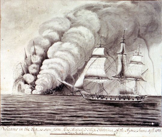
During the eruption, two “teams” raced up to the eruption to place a flag on it, between lava bombs and falling ash, both teams safely arrived on the new island. The importance of placing a portuguese flag is due to another eruption in 1811, when a British ship placed a British flag on a new island that was formed 2/3km south of São Miguel island.
“When Tillard revisited the island some time later he found boiling water rushing from fissures. This did not deter him from raising a Union Flag and claiming the island as British, confirming it by a message lodged in a bottle at its base. He named this latest British possession “Sabrina Island” in honour of his ship.
Tillard’s claim of the island – within little more than a gunshot’s range from the island of São Miguel – had all the potential to cause a rift in British-Portuguese relations, all the more undesirable since both countries were allied at the time and prosecuting a vigorous war against France. A higher authority was however to settle what could have been an unwelcome diplomatic confrontation. When a British survey ship arrived on the scene a few months later all traces of Sabrina Island had disappeared as quickly as she had arrived.”
https://dawlishchronicles.com/the-spectacular-life-and-death-of-sabrina-island-1811/
Sabrina Eruption
Great info Azost, sometimes i wish we had NOT a smilie but an “Enjoyable Information sticker” esp for infrequent repliers…. Consider that You have been given an “Enjoyable Information” sticker, Azost. 🙂 Best!motsfo
Thanks for the feedback.
I find both flag stories curious, in Sabrina eruption (1811), the nerve of a British Captain claming the new island near shore of a habited portuguese island, months later erosion took the island and the flag away.
In Capelinhos eruption (1957/58), two teams, one local and the other from Portuguese mainland with jounalists and a french movie director, raced in rowing (fishing) boats toward the new island, while erupting, risked their lifes just to stick a flag on it.
Didn’t find photos of this, some small raw videos of the boats.
er and on a personal note: i’ve experienced a plethora of very small earthquakes in my immediate area and just expecting (NOT forecasting) a larger quake… so i’d like to go one the record saying i’ve enjoyed this site very much and think of You all as friends.. so be good and don’t do anything stupid to make me change my mind…..
Best!motsfo
Try this. Since it is in our media store, you can copy the link and drop it in your comment.
And also note that your quake activity is probably a slow release of energy rather than a large one. If they slowly taper off, it’s probably a good thing. If they stop abruptly, ya might worry.
Nice idea – even better if “Information” had a ‘T’ in it!!
Bah… shpelling.
I am sure you will be fine, Motsfo. Please keep us updated!
The quakes seem to be at a depth of 50-100 km, so subduction related. Keep you feet on the ground and if in a hole, stop digging!
https://www.facebook.com/ikaika.marzo/videos/1974020775983782/
I think it might actually be over for real this time, first time it has been completely empty and collapsed.
Apparently the east rift is showing some slight inflation though so there is still magma feed, it will be interesting to see where the next eruption is in that case because it might be more complicated than the scenario I have been following. If the east rift is still the dominant eruption center after an eruption as big as this one then that indicates a potential for another very big lower rift eruption in the future, maybe even where the lighthouse is which would be interesting. 1960 happened near the end of the 1955 dike so if something like that happens now it could be expected that an eruption would happen somewhere between cape kumukahi and fissure 17, which is not good news for those who want pohoiki to be around for a while… The other scenario is an eruption near highway 130. I wouldnt expect either to be very big though, most of the magma is drained out, but its all guesswork at this stage.
Maybe that is what occurred in 1790 too, explaining its double rift which seems unlikely to form otherwise. The first eruption probably caused a collapse at the summit and was probably on the south part of that eruption near this years fissure, and then maybe a few months to a year later there was a second eruption further north that was more brief but finished the job and completely took out the rift from further activity for a while. This is also similar to 1955 being followed by 1960.
I saw this on FB. I’m hearing it’s Pu’u ‘O’o. Has anyone else heard anything more or what’s your thoughts?
On Ken Boyer’s FB page:
Appears Pu’u ‘O’o is having a large rockfall explosion episode. Will keep an eye on it but not too concerned at this time.
One of the replies was David Ford post this with picture:
090818 Plume on upper East Rift zone, about 10:00 am. I’m guessing it’s Puu Oo, but it looks slightly down rift, above Royal Gardens Subdivision.
https://www.facebook.com/photo.php?fbid=1521186388027350&set=a.582387968573868&type=3&theater&ifg=1
There were a couple of other pictures from others too.
If you have seen how deep its inner crater is it would be notable if it wasn’t collapsing. The bottom of it is probably 500 meters deep and maybe more. I wouldn’t be surprised if the crater ends up being close to 1 km in diameter by the end. There might not have been any collapses in the chain of craters area but there was definitely a major draining of the east rift, just most of it was through pu’u o’o rather than the upper rift like what (probably) happened in 1790.
As for the plume being a bit downrift of pu’u o’o, that area had a lot of shallow conduits (initial 1983 fissure, kupaianaha, 1992 vents, July 21 2007 vents, peace day/episode 61 complex) so it wouldn’t be surprising for collapses to happen there too. That whole area will be changing for a long time as the steep areas collapse and voids reach the surface.
I’ve seen flyover pictures of it. Knowing that it had drained I thought it was a collapse, but always like to hear people’s opinions at the VC. The info about “being a bit downrift” makes sense why it appeared that way to him. I had wondered about that. Thanks 🙂
Yeah the difference between this years collapse and the 2011 collapse are pretty huge when you compare them.
This is 2011 less than 2 weeks after lava returned to pu’u o’o after draining:
This is from May 3 at the same time as fissure 1 was active:
As you can see there is quite a massive difference in the depth of the craters. Pu’u o’os 2018 crater is actually the second biggest crater by volume on kilaueas east rift right now, only makaopuhi is bigger. It is almost like kilauea had two caldera collapses in a way, even if pu’u o’o doesn’t quite qualifiy as its crater isn’t 1 mile wide.
Pu’u o’o is also almost certainly dead by now, it has been 4 months since it was active, and its shallow magma system has been destroyed. When kilauea reactivates it will be somewhere else on the volcano. The east rift might not be out for the count yet but the most likely place for the next eruption is at the summit. 1955-1960 was separated by only 5 years but in that 5 year gap kilauea had a major summit eruption so things are going to be very interesting to watch. Im going to predict (not that it really helps much at this point) that the next eruption will happen late next year at the summit, as by that point there will be around 0.3 km3 of magma recharged, and when it erupts it will probably be a pretty powerful eruption with high fountaining and maybe explosive activity. Then some point within a year after that another eruption might happen in lower puna maybe further downrift of where the recent activity is and roughly using the same dike, happening on a line of fissures about where kapoho used to be, and covering part of the 2018 and 1960 flows and maybe also pohoiki if it gets into that drainage. This eruption might be a lot more intense though not as big or long lasting as this years eruption. It also might become phreatomagmatic.
Being at such a low elevation it will probably completely drain out the summit magma chamber all the way to the feeder and kill the rift zones for a while, resulting in a 1790-like period like my previous ideas.
When Puna was settled, it was a lush region. Now it is a lava desert. It takes quite a while for lava to become forest: a century may not be enough. The crucial episode was 1840. After that, the rift zone must have died and the region had time to green up. The quiet times ended more than 50 years ago, and since that time most of the rift zone has been overrun. Pu’u’O’o itself is included: it too resurfaced a rain forest that must have been a long time in the making. What comes next? All known eruption points of Kilauea are dead and drained, apart from some potentially eruptable pockets left over from Leilani. It now depends completely on where the easiest way for the new magma goes. Everything goes through the Kilauea magma chamber, so it is natural to expect some re-inflation here, but it depends on how well the upper rift is blocked. It became blocked very suddenly, with the short earthquake sequence south of the main crater, but that says little about how well the block will hold if the pressure in Kilauea returns. A solidified rift never re-opens, by the way: instead magma creates a new pathway parallel to it. The southwest rift zone may be the next one to give way but it is guess work!
I’m guessing that a .5 km^3 infusion from the mantle plume would happily just look for the easiest path. A multi km^3 infusion, however, would probably just cut through whatever was in the way like a chainsaw though hot butter.
Whatever comes next could be interesting for sure. As much as Hawaii has been studied, modern-era humans have still really yet to first-hand witness and document anything in Hawaii that is remotely approaching the scale of some of the estimated pre-1840 events.
It takes more than a few years for a dike to solidify, and the interior of kilauea is very hot. The south Iceland volcanic zone where skaftar fires is often gets called the dead zone because of quakes, but kilauea is way hotter than that, and the only reason quakes happen is due to faulting of the south flank and near continuous magma movement.
It takes a really big event to directly intrude and erupt in the LERZ, probably around 0.2 km3 as an intrusion. 1840 was big enough, and also happened slowly during a time of high activity at the summit probably over a several year period before it became favourable for magma to go out the side instead.
1924 was also deep but was never big enough to erupt, and this is evident by 2924 not being a significant collapse event despite the massive effect it had on activity.
1955 was also not big enough on its own and happened only after several upper rift intrusions, and residual heat from 1924 probably helped too. 1960 definitely happened because of 1955, the fissure was very small for such a big eruption and it is pretty close to the lowermost 1955 vents (which were buried in June).
This years eruption was the result of at least 50 years of magma being emplaced at high elevation within kilauea, a lot under pu’u o’o but most of it under halemaumau and the south caldera, and some more under the mauna ulu area which might see some collapses over time. When pu’u o’o got too high (I think the height of the crater floor in April got over 90 meters above the base) and a new pulse of magma came into the volcano it hit a breaking point and the south flank below pu’u o’o down almost to cape kumukahi was shoved out of the way, most of it all at once on May 5th. The rift will remain basically molten for a while, so if kilauea reactivates quickly and builds a lot of pressure it could end up with a similar situation to 1959-1960, a powerful eruption at the summit followed by a second big draining event, and then it might be that one which actually completely terminates the east rift, though it will be relatively much smaller than this years event (relatively is a light term though as it might still exceed 1960 in volume) There have been reports of the east rift inflating between pu’u o’o and Leilani so it might not be closed off just yet, it’s still at a really low value though. All of the vents are sealed so it will take some build up to cause a new eruption, probably about a year, so whatever happens in the end will not be small or unnoticed.
A similar sort of situation could have happened in 1790, I don’t know if studies have actually proven that an eruption happened on both sides of the rift at the same time that year, only that they are evidently very close in time and date to the late 18th century. Maybe the north rift of 1790 happened as a sort of secondary to the south rift (which might have happened in the 1780s after heiheiahulu) with a period of summit activity or recharge between them for a year or so.
In recorded history kilauea has been relatively quiet, we still have yet to see a 1790 sized summit eruption (that might not be a long wait though). We also have yet to see a shield building summit overflow. Maybe most importantly and unfortunately though, we have yet to see kilauea when it is violent, and that is a very sketchy situation with the events now. HVO can warn about events but we all know it will take the real thing actually happening to get it out there, and it seems like it will end in a worse case scenario if the park is opened again.
Also if several km3 of lava intruded into kilauea in one go you would most likely get a VEI 5 basaltic plinian eruption like what happened in 800 AD, followed by extremely rapid summit filling simultaneously with major rift eruptions on both rifts and probably even an eruption on mauna loa. It would be basically like an Icelandic flood basalt. This is very unlikely but not impossible now, and when kilauea goes through its peak growth stage it will likely have many eruptions like this.
I personally think the ERZ is not done for now and that we are going to see more eruptions there, maybe after some summit or SWRZ activity or maybe not. My main reason to think this is that I am pretty sure there is still plenty of magma left along the rift zone conduit. Since the east rift zone shield of Kane Nui o Hamo formed, usually placed around 1300 AD though my opinion is that it is a little more than 1000 years old (I am not sure where the 1300 AD date comes from since no radiocarbon dating has been done on any Kane Nui o Hamo flows). But anyways, since Kane Nui o Hamo there have been clearly at least 2 episodes of pit crater formation in the upper east rift zone as some of the craters are actually two overlapping collapses, and I think that almost certainly eastern Makaopuhi crater represents a third episode of collapses older than the other two. These collapse events seem to involve multiple craters along the upper ERZ and that do not show any clear tendency to form near long lived vents. The last craters formed during the 18th century and very probably towards the end of it, the 1790 eruption might have had something to do with it. The observed mechanism for the formation of the craters is by removal of magma from an underlying reservoir and following collapse so this events happening periodically means that the upper east rift zone is likely to currently have multiple magma reservoirs now that more than 200 years have passed since the last collapses, and not necessarily under Mauna Ulu. If this is right then the ERZ is still an open conduit.
In the summit the collapse seems to have taken out all or part of the shallow Halema’uma’u reservoir but the one underlying the south caldera rim would still be intact and is the one from which intrusions to the ERZ and the Seismic SWRZ start from. Right now the plumbing system of Kilauea doesn´t seem to be very damaged after the eruption, Pu’u’o’o might have taken the worst hit and the volcanic SRWZ which is connected to the shallow Halema’uma’u reservoir might be temporarily dead due to the collapse. We havent observed a situation like this in modern times neither would I call this a repeat of 1790, multiple options remain open, one of them is that a sustained vent like Pu’u’o’o or Heiheiahulu will open up in the LERZ, maybe in fissure 8 which is what I think HVO was expecting and would not be that unlikely. Other posibilities to be considered: summit eruptions (high fountaining likely), an ERZ fissure eruption. Pu’u’o’o coming back (unlikely in my opinion)…
I compare this to 1790 because of the size and effect on the summit that this eruption has had, nothing between then and now has even come close or even got half way (1840 was the closest at 0.3-0.4 km3 including the volume probably underwater). Nothing before 1790 up to about 1500 is close to this either.
Kane nui o hamo made the lava that the pu’u loa petroglyphs are on and apparently those have been dated to around 600-800 years old but I cant find where I read that.
I dont think the supply rate from depth, as high as it is, can keep a dike open all the way to the LERZ. Heiheiahulu formed almost on top of another shield from about 200 years earlier and there have been several large shields further up the rift, but all of the lava in the LERZ is from short vigorous eruptions like the one this year, eruptions that drain out the summit more or less and sometimes end periods of rift activity, and nearly all of them seem to be pretty big at least 0.1 km3 up to about 1 km3 for 1790 and maybe 1.2 km3 for 2018.
The spot where the steaming cracks near hwy 130 is could be a possible spot for a long term eruption though, that is close to that area. I think when another eruption happens though it will be in halemaumau first, as it is the weakest link now, there is only maybe 1 km separating the remaining magma from the bottom of the caldera, and the bottom of the caldera is around 500 meters above sea level or maybe 100 meters above pu’u 8. It could be like what happened in 1959, a vigorous summit eruption followed immediately afterwards with magma going down the rift to erupt near the ocean. However unlike 1960 there isnt much magma left inside kilauea so I dont think the rift will keep going with frequent activity after a double big eruption. As you probably read above, that is possibly what also happened in 1790, although instead of going downrift it made a new dike.
There seems to be a battle between the summit and lower rifts driven by gravity. It would seem easier to have magma erupt at lower elevations in the kapoho area which is over 1 km below the summit, but to actually get the magma there requires a 50 km long dike, and unless there is a large supply available that isnt possible. So normally magma will go to the summit where it has to rise up 1 km higher but only move maybe 3 km total. When a large shield opens on the east rift, it is usually in a place where many dikes and small eruptions have happened before, pu’u o’o is a very good example. The easiest path now went into the rift, and summit activity died off to almost nothing with a few exceptions in the 1980s, 2015 and 2018 when small flows occurred. Several times intrusions did go downrift of pu’u o’o, most recently in 2007 but never had enough pressure behind them to go all the way, until in 2018 it finally broke, the lower rift was activated and then all hell broke loose.
This area will only erupt when there is a lot of magma, so all eruptions here are always at least fairly big and often are very sizeable by world standards, the effusive equivalents of VEI 4 and VEI 5. Then eventually a bigger one drains the summit out and forms a caldera. This is the effusive equivalent of a VEI 6. This eruption will probably leave the rift full of magma, and then shortly afterwards when new magma arrives it heats up the system it gets that stored magma moving and that erupts even lower down and causes collapses on the rift and deactivation. During or after this activity there will probably be major summit activity that beings the cycle over again.
I guess the reason this doesn happen on the southwest rift is evidence most of it is shallow and more superficial. Most of it might be entirely dead now too, although the seismic rift could well become very active in the future.
Kilauea iki is a wild card, it seems to be a central source like halemaumau with its own feed from depth that might be outside the upper chamber but which is only rarely active, basically a parasitic volcano. 1959 might have been the first big eruption from it since aila’au, the other historical eruptions were probably accidental flank vents of halemaumau that used weak spots in that area and had no real connection. If this is true then kilauea iki might be able to erupt completely independently from halemaumau and so add another variable.
Well, this is obviously something significantly different than any other post-1840 event at Kilauea. Combined that with the fact that everything related to pre-1840 eruptions (including dates and eruption volumes) is best guesses, I still say that whatever comes next could be and probably will be interesting. Could easily be something at the summit, ERZ, SWRZ, or any combination of those. Plus, the overall caldera plumbing is probably pretty messed up at moment (compared to pre-2018) so even a small intrusion of fresh magma will hit piles of cold loose rocks and dirt about a couple of kilometers lower in the summit area than it would have in April. Hot basaltic magma + cold loose rock = https://encrypted-tbn0.gstatic.com/images?q=tbn:ANd9GcQ3Bdu409rOMbmEKqHneDWkj-UuKVkM82SFAkDYG6zHNjwpqe-C
Kilauea Iki, Halema’uma’u and the south caldera rim are the three locations of eruptive activity within the summit area and each of them are probably underlain with magma reservoirs. It looks like if the summit does not have a fixed location, around 500-800 years ago the main summit vent was in the northern part of the current caldera, the Observatory Shield which collapsed around 1500 and has been inactive since then. More or less at the same time as the Observatory Shield, Kilauea Iki was a secondary summit vent that probably was in a continuous eruption for several decades (the Aila’au eruption).
I am not sure if the ERZ is ready for another major eruption though, I dont think there is enough pressure left in the system to erupt a large volume of lava. The Leilani fissure wasn´t able to drain out the magma sitting in the south caldera reservoir and in the upper east rift zone for one reason or another so it doesn´t seem likely that in the current situation another ERZ eruption of similar characteristics will be able to do that, a sustained eruption in the LERZ like Heiheiahulu maybe is possible and would allow for the rift zone to slowly recharge with magma and build up pressure for another large fissure eruption to happen and maybe cause a full collapse. This phase of ERZ activity is already probably already more voluminous than the ones in 1500 and before 1790 and Pu’u’o’o seems to be the largest ERZ eruption since at least Kane Nui o Hamo which might very well be more than 1000 years old.
The problem is that this collapse is as big as 1790, this eruption is as big as 1790, and happened in the same place as 1790. It has not drained out the rift though, which leaves a problem. I read a paper that said none of the puna ridge is less than 2000 years old, so the recent calderas dont apparently form from eruptions there. However each time there is a significant collapse of the summit there seems to have been a big eruption in the LERZ, this year included. My idea is that most of the draining in 1790 was from one rift (probably the south rift), and the other was from the east rift draining mostly unaided by the summit and for some reason it made another dike instead of extending the existing one. The north rift in 1790 was probably not very big compared to the south rift, its flow never made it to the ocean and stayed relatively thin, but it covered a wide area. This second event might be what is still coming. Also the difference in elevation between kapoho and leilani estates is not insignificant, kapoho now with the new lava is maybe 30 meters above sea level compared to 250 meters at pu’u 8, and 800 meters at the top of pu’u o’o, and still over 100 meters lower than fissure 18 which was the lowest fissure to erupt new lava. This hypothetical second eruption wouldnt be as big as this years eruption, it might only be 1/10 of the size but it would drain out all the magma that is still within the rift zone.
I would agree that this euptive episode is very big though, pu’u o’o is probably bigger than the entire >1790 episode on its own put together.
I have looked at the data for pu’u o’o and how big it is and it is actually very interesting. Apparently 1 km3 of lava erupted in the relatively weak activity between 2011 and 2017, which gives an average of about 5 m3/s of lava, which I think is what HVO has said before. Pu’u o’o erupted for about 36 years so the volume should therefor be roughly 6 km3, maybe a bit less. However for most of the earlier part of the eruption up to mid 2007 the average eruption rate was a lot higher probably about 10 m3/s or even higher, which means that there was actually about twice as much lava erupted between 2001 and 2007 as between 2011 and 2016. With these numbers pu’u o’o actually has a volume of around 11-12 km3, with a very significant portion of that ending up in the ocean. That means the pu’u o’o eruption is actually significantly bigger than the aila’au flow unless that has also been significantly underestimated.
It should be pretty obvious too, if pu’u o’o really had a volume of 4.5 km3 after 35 years then its average eruption rate would be only about 0.4 m3/s, but it was erupting continuously at least 10 times that rate with only about 3 months total of no eruption between 1986 and 2018. The maths doesnt add up with the reported numbers at all.
Mauna ulu has also probably been significantly underestimated. If 1 km3 of lava erupted in 6 years at only 5 m3/s from pu’u o’o, then mauna ulu lasting 5 years with a pretty obviously much higher eruption rate likely over doubled that easily.
By extension with this, it is pretty plausible that all of the ‘smaller’ shield eruptions on kilauea probably have volumes of between 1 and 5 km3, with bigger ones like kane nui o hamo and pu’u o’o between 5 and 15 km3. Summit caldera filling events that overflow like the observatory shield probably have volumes in the 10s of km3. Aila’au might be unusual in that it might be less voluminous but its eruption rate a lot higher so the flows were more extensive and flowed a lot further. It could have been several shield eruption separated by years of not erupting, a behavior that could occur again if a stable open conduit opens to kilauea iki at some point.
The amount of lava erupted by all the other large historical rift eruptions is about 2 km3 with half of that in 2018. There is also the roughly 7 km3 of lava that erupted in the caldera between 1790 and 1924, which brings the total up to 24 km3 for this eruptive episode. 24 km3 of lava in only 230 years, I dont think any other volcano on earth can even claim to be comparable.
If you draw a line that connects the Aila’au vent with the center of the three pits that make up Kilauea Iki crater and you continue it west you get to the past location of the Observatory Shield vent. I think Aila’au developed in a small rift zone that extended radially from the Observatory vent and that no longer exists because the volcanic and gravitational spreading has moved south together with the main summit vent, it also must have formed as a flank vent when the Observatory Shield was high enough for the magma to have to look for an easier path.
I continue to agree. In my opinion also, the impact and significance of the Hawaii volcanoes has, in general, been vastly underappreciated. Probably mostly because they have not historically produced giant VEI7/8 craters and the associated tephra deposits for geologists to hunt down and write papers about. Basaltic eruptions are just not as sexy as the giant mushroom clouds of gas and dust from stratovolcano explosions.
That is probably true, but evidently it isnt dead as 1959 still happened. The 1959 fissure did follow the shallow zone from halemaumau so it was connected, but there was definitely another source too, if it was fed entirely from halemaumau there wouldnt have been 1250 C olivine basalt erupting there. 1959 was a major recharge event for kilauea.
I also looked at the numbers for the amount of lava erupted at kilauea, and with an average flow depth of 15 meters it would take 200 km3 of magma to completely resurface it. 90% of kilauea’s 1500 km2 area is less than 1000 years old so this is pretty accurate. That means in am average 100 year period for the past 1000 years 20 km3 of magma should have erupted on kilauea, and pu’u o’os 12 km3 added to the 4 km3 of other eruptions is about right, with 16 km3 since 1955 and likely to be a lot more again by 2055.
In the holocene it is very roughly possible to extrapolate kilauea to have erupted 2200 km3 of magma, about 1/20 of its volume but in only 1/50 of its total lifetime. That much basalt cooling from 1100 C to 25 C would release the amount of energy as an explosive eruption 50 times bigger than any that has ever occurred in the Earths history…
When it reaches the peak of its growth maybe 200,000 years from now it will be erupting about 3 times higher rate than it is on average now, around 1 km3 every 2 years, a rate that exceeds even the monster volcanoes of vatnajokull, and is more than an order of magnitude higher than any other individual volcano anywhere.
All these big numbers…
1500 km2 to a depth of 15 meters is 20 km3, not 200. Phew.
Based on:
Characteristics of Hawaiian Volcanoes
Edited by Michael P. Poland, Taeko Jane Takahashi, and Claire M. Landowski
Poland, M.P., Takahashi, T.J., and Landowski, C.M., eds., 2014, Characteristics of Hawaiian volcanoes: U.S. Geological Survey Professional Paper 1801, 429 p., http://dx.doi.org/10.3133/pp1801.
https://pubs.usgs.gov/pp/1801/
Chapter 3
Growth and Degradation of Hawaiian Volcanoes
(Figure 6 , page 107)
The total volume of the major volcanoes that make up the Hawaiian islands is approximately 560.6 km^3.
Simple math….if the islands in total are about 2 million years old, then overall the Hawaii hotspot has been pumping out magma at the rate of about .25 km^3 per year for a while. That’s quite a lot.
560,600 km^3
Yeah I did the maths wrong but it was at 1:30 in the morning and I only realised after I had already posted the comment. I also thought about it afterwards and applying the surface area and depth average doesn’t really work because most of the lava will flow into the ocean as pu o’o has shown. If pu’u o’o has been erupting at a rate of about 7 m3/s over its entire eruption then it would have a volume of a lot more than 4.5 km3.
4.5 km3 / 1104492410 (number of seconds in 35 years) = 4.07 m3/s (I added another 0 to the second number yesterday it was late 😉 ). That is probably what the post 2011 average was but that period is noticeably less active than before.
12 km3 / 1104492410 = 10.8 m3/s.
That eruption rate is a lot more realistic for most of the time before 2007. Back then it wasn’t unusual for flows to have multiple lava tubes with each having sizeable independent ocean entries and breakouts feeding yet more lava flows that would also reach the ocean and all fed from one vent that was just one of about 5 actively erupting. Often new vents would produce new flows while the old flow and vent remained active for months afterwards, in 2004 you even got an old flow reactivating and reaching the ocean again after being superseded by another flow. On top of this there were always eruptions in pu’u o’o while very few lava flows erupted in pu’u o’o after 2014.
Pu’u o’o really shows how it is shields that are the main way kilauea grows, with a volume of between 11 and 12 km3.
Le Chaudron de Vulcan is reporting activity on Iwo Jima (Iwo Ioto), well known here from the NDVP series. It states ‘ according to the Japan Meteorological Agency, Iwo Jima, in the southern Ogasawara Islands, has seen the number of volcanic earthquakes rise from 2 in the morning of 8 September to 566 on 9 September.[..] it is possible that an eruption will occur on the island or on the coastal sea floor.’ But the picture it shows is a different island, and refers to a crater which Iwo Jima does not have. So I am a bit unsure which island the warning refers to!
The photo shows a similarly named island:
https://en.wikipedia.org/wiki/I%C5%8Djima_(Kagoshima)
I think it’s only the photo that’s wrong. Here is (at least I think so) observation data for the Iwo Jima in the NDVP series. The increase in earthquake frequency seems consistent with what’s reported by Le Chaudron de Vulcan.
https://www.data.jma.go.jp/svd/vois/data/tokyo/open-data/open-data.php?id=329
USGS lecture on Kilauea
Hawaii is under a tropical storm warning.
For all.
There has been some back channel discussion among us about the reliability of various hurricane models. From the latest discussion about Florence, the NHC had this to say about it’s own forecast tracks.
“
It is important not to focus on the exact forecast track as average NHC errors at days 4 and 5 are about 140 and 180 n mi, respectively, and dangerous hazards will extend well away from the center.“I was reading the discussion regarding Florence on hwn.org about 12 hours ago. She looks like a real brute, both in terms of intensity and size. So people would do well to heed their warning, because 140-180 n mi deviations probably don’t count for much. If you were in the forecast track, you’re probably still in it.
You don’t get to sidestep out of the way of a sawn off shotgun !
Best wishes, and stay safe all.
Very accurate statement. To give you an example, Gordon was projected for MS-LA border but “wobble” put the official landfall at the MS-AL border. The storm center actually tracked directly into Mobile if you beleive the radar. Over here in Florida, we caught the heavier winds. Tropical systems are LARGE critters. Slight deviations in track can catch you unprepared and mess your day up fast.
I have a lot of experience riding tgese,things out, but do note, even I would blink and evacuate if the storm looks as mean as this. Especially if I were in a surge zone.
I’m of the opinion that Florence will drop in strength before landfall as the model runs state. But once a storm reaches Cat4 or 5, it will still carry that mass for a,while even if it drops in strength. That means the established wind feilds will still be in place. If the storm suddenly winds up over warmer water, (like the Gulf Stream) it could easily ramp back up in strength. Hugo did that and nailed the coast HARD.
Caveat: Not a,weather person, but I’ve had several encounters with Tropical systems and live in the shooting gallery.
I don’t have a vast experience of living through storms as intense as hurricanes… some, but not much.
But I would imagine that if you had the choice between a Cat 5 and a Cat 3, that might be somewhat akin to a choice between being hit by a truck or a train ?
Either would represent a bad day at the office.
Nice analogy, I would say that it’s not that bad…. but it is. Imagine 115 mph wind for hours non stop. That’s the Cat 3. You can hear stuff banging and moving around outside and can’t do any thing about it. Your mind tries to work out what that last noise was and does it present a danger. You do a lot of introspection. “What if…” thoughts. Your family is gathered around you wimpering and scared, you try to keep them calm but you aren’t sure what is happening either and if you are wrong about “it’s gonna be alright.” Then the power goes out and you are sitting in the dark hoping the building holds out.
In a nutshell. That’s the Cat 3.
Wow… Sort of the scenario I thought it might be.
I’ve experienced 2 extra-tropical hurricane strength storms, one of which was distinctly unpleasant, and back in 1970 when my family escaped South Africa some of us came back to the UK on the SS Edinburgh Castle, which had no stabilisers and we were caught in a fierce force 9 storm in the Bay of Biscay. Seas were way higher than the top deck, which for those of us with no prior experience of sea voyages was unnerving enough, but then when we went to the galley for our meal the ship was struck broadside by a rogue wave which pitched it instantly about 60 degrees…people thrown off their chairs, lights out for a second or two, hot food and shattered crockery everywhere. THAT was a scary, helpless feeling.
Living within a riot zone in 86 even was nothing compared to that.
But I have some knowledge of what a surge is like with my particular taste for tidal bores and the history of the Severn Estuary. I don’t envy anyone for whom this might be a year in-year out consideration.
Storm surge is a lot like a tidal bore… but the water doesn’t stop coming for a looooong time.
Yeah, it’s a parody of the Journal of Human Evolution, but I think it sort of deserves a publication of it’s own… “Documenting the travails of Homo Stultus.”
I like it!
Complementary to the Darwin Awards.
And just to highlight my intent…
Prior to 2004, using the Tsunami run-up data from NGDC/WDS data sheet located here: https://www.ngdc.noaa.gov/hazard/tsu_db.shtml
The average tsunami is 1.67 meters with a standard deviation of 3.45 meters. Pre-2004 was chosen to exclude the monster tsunami from the Sunda Trench and should best reflect the available data for coastal risk assessment prior to 2004.
Keep in mind that Albert has already shot holes in part of my idea… actually indicating that the specifics were worse than I thought.
When the 2011 Tōhoku earthquake and tsunami occurred, the run-up listed is 20.79 meters for Fukushima. That is a 5.54 sigma event with a likelihood on the order of 0.00031% of occurring. Dragging out the Black Swan meme again, the first part of the definition is that the event have so low a probability that people unwittingly think of it as impossible. Part two of the definition is that the event is profound in it’s effects… and part three of the definition is that it is explained away after the fact… sort of what I’m contributing to here.
Now, I noted that Albert showed that it was worse than I thought. Here’s how. My assumption was that hazard analysis would have shown that there was a definite, though quite low risk since Japan was a strong adopter of Dr Demings statistical techniques for process improvement, especially in auto manufacturing. The very same statistical work would have given clear indications of what could be in store. The worst part? No one even used it. The sea-wall of Fukushima was designed to withstand the largest tsunami seen in the Pacific basin. What they got dwarfed that.
Now, just like many Scifi movies, one person saw the potential problem and voiced concern over the threat. Dr. Kiyoo Mogi. The very same Mogi that gave us the Mogi model for estimating the volume of magma influx into a system based on surface deformation. As a seismologist and originator of the model, his attention was focused on GPS and deformation data… he most likely noted just how stressed the crust underlying Japan was and saw that there was a potential problem with how much energy was stored up in the fault systems. Dunno for sure, I’m not Kiyoo Mogi, but it makes sense to me.
For the record, I’m not an expert in any of this, I’m just a fanbois of disaster prediction and mitigation…. and I have been through the USN’s Quality Assurance course. (Which is where my knowledge of Dr Deming comes from)
😀 😀
HVO has given us a new webcam looking directly into the cone of fissure 8:
https://volcanoes.usgs.gov/observatories/hvo/webcam.html?webcam=LQcam
Now we’re ready for a resumption of activities…
Not to mention the cajones of the crew that set it up.
It’s not that I fear volcanoes, I just don’t like being around something that can kill me with no warning. It sends a chill up my spine.
Yeah, I hear you.
I was wondering if they were using a good tele lens on that camera? It would give them a bit more of a safety distance for both the crew during set-up and the camera itself…
Even a nuclear weapon test close up camera can get covered in lava 🙂
Worth a shot though.
https://www.youtube.com/watch?v=GkyaX5shIH4&ab_channel=GabeHumphries
Not new but this is the July 19 surge viewed from the top of pu’u kaliu just west of pu’u 8. If you have ever wanted to see lava flowing at over 40 km/h on a flat slope…
This guy has a lot more videos too.
https://www.facebook.com/phil.hawaii/videos/10216162865566394/
Todays livestream from Philip and John about 2 hours ago,
I think they actually read this site because a lot of what they talk about around 30 minutes in sounds very similar to the discussions we have been having here. I mean I have also used them as sources to some extent but it is interesting to think 😉
Philip is a geologist and working on his advanced degree. John was a ranger at the volcano park and was gone a month to do some work in Alaska but I am not sure of his background. He was on a glacier in Alaska. Both are very knowledgeable about this volcano and easy to understand.
Yes they have a way of explaining the subject to the general public without being confusing.
The part where they mentioned Don’s prediction of possible further and even bigger collapses is definitely worth watching though, Don Swanson is probably the world leading expert on kilauea by a long margin (and that is really saying something) so if he thinks something is about to happen there is a pretty good chance it will. Don has probably spent more time directly in the field looking at lava than the entire time I have been alive… 😉
Looking back to the first HVO conferences in late May you could see how nervous he was when the still small eruption at that time started rapidly intensifying and halemaumau began to collapse on a large scale, his entire career was largely centered on past events similar to that and notably he had been warning that such events would occur in the future too. That future is now the present…
Yes I remember watching him. He was very cautious and looked a little worried. The system was full of lava and it was going to go somewhere in lower Puna. Authorities was probably pressuring him to tell them just where it would end up.
Interesting things. Regarding fissure 8, they missed one possible cause of the intermittent flows. A deep dike is kept open by the magma pressure. As the magma drains, the dike narrows a bit and this keeps the pressure down-stream stable. Narrowing of the dike can a pressure wave traveling down which pushes the lava out a bit in fissure 8. Later, the pressure drops again and the lava drains back.
From which source did Surtsey get his magma? Was there a long underground pathway from the magmachamber below Heimaey or even Eyjafjallajökull to Surtsey?
“Surtsey – The Birth of the Modern World”, that event was simultaneously with emergence of The Beatles, should we call Surtsey The Beatles Volcano?
Not from the Surtsey/Eyjafjallajökull magma chambers, you need to go deeper into the magma reservoir of the ERZ or MORB derived magma. It was a unique source with a unique signature due to mixing at the propagating tip of the ERZ:
https://www.nature.com/articles/srep11498
OT… just outside watching the aurora and caught a bright display of “Steve” and the neighbors cat scared us with her bright glowing yellow red eyes…. we don’t normally scream and run when she shows up. Best!motsfo
Round here we have these field spiders that hunt at night. If you are wandering around after dark, like in search of the privies while camping with the scouts or walking the dog, shine your flash light over a field of mown grass and you can see pairs of their jewel like eyes staring back at you. It’s easy to mistake them for drops of dew reflecting the light, but they come in pairs and refract the light like diamonds, beautiful but creepy.
One of these days I would like to travel someplace where I can see the aurora and the Milky Way. We have too much light pollution on the East Coast to see that sort of thing. Though I will say this for light pollution, as a college student, I never felt scared walking home from a swing shift at the library 24-hour desk. On cloudy nights, it was even brighter. Last night walking back to my car after work, it was foggy and misty from the remnants of Gordon and the sky was glowing deep red, really impressive.
I was looking at the latest tracks for Florence. The extended tracks show this hole around Central Maryland, which is where I live, showing that we will avoid a direct hit by the storm center. However, depending which track it takes, a bunch of them show us getting the Eastern side of the storm. Lucky us. I expect though, whatever reaches us will be at worst a cat 1 storm, but more likely down to a tropical depression if even that organized. Well, I have the new season of The Ozarks on Netflix to entertain me this weekend.
https://www.wunderground.com/hurricane/atlantic/2018/hurricane-florence?map=ensemble
While much more benign, don’t underestimate a Cat 1. I was driving around after Erin and was quite puzzled at what appeared to be an oak tree poking up from the middle of the roof of a a convenience store. It had had landed roots down and looked as if it has grown there. During landfall I was amazed at the pine trees across the street that were bent over sideways like blades of grass. This was my first landfall and I had no idea that pines could do that. In my opinion, pines are perfectly adapted to endure that sort of punishment. Pine is one if the more flexible species of wood, and their leaves are needles, cutting wind resistance as they just bend to the most aerodynamic shape as the storm goes by.
An important thing to remember about storms comes from comedian Ron White: “It’s not that the wind is blowing. It’s WHAT the wind is blowing.” “If you get hit with a Volvo, it doesn’t really matter how many sit-ups you did that morning”
So much for Volvo being a safe car 😀
Dunno about that. In his mind, evidently a Volvo is about the only brand that is durable enough to remain intact and pose a debris threat.
In the UK’s “Big Storm” of October 1986, in effect a Cat 1 (even though it was actually just a nasty sting-jet low pressure), the pines here snapped off about a third of the way up. Most other trees either survived or toppled. But the pines – almost to a man were snapped off.
At the peak we had sustained winds of around 40, and gusts to 110mph. There was a 20 minute period where the wind did not drop below 94mph. A scary night for the quiet old South East UK! I recall the debris banging against the windows and our old Victorian house wobbling (not shaking – wobbling). And I’ll never forget that sound of that wind roaring like a jet engine.
No doubt you are more used to this!
You never get used to it.
Probably the freakiest storm I went through, was in the North Atlantic as we were coming back from Ireland. A tropical system was moving NE off the US Atlantic coast and tracking towards the Icelandic Low (they all do) and we had dropped south to “duck under” its track. After it had passed, it turned south, then west and seemed to be following us. At one point in the middle of the evening, we hit a set of swells that would rattle anybodys cage. A “belly band” on the port aft refueling station came loose and the fueling hoses began beating on the side of the aft superstructure next to the helo hangar. This went on all night long because there was no way we were going to endanger anyone to go out in the dark with this hose whipping around beating the side of the ship.
No, not a sexy ship to be assigned to, I think my detailer had it out for me and sent me here. Though not pretty, this ship could haul some serious cargo and excelled at it’s job. The USN retired all the Sacramento class AOEs because they were so much manpower to operate. (600 psi steam plant) If it looks as big as a battleship, that’s because the original keel design was for battleships to follow-on the Iowa class BB.
October 1987, 125 mph at the Needles lighthouse Southern England.
Category 3 hurricane.
I was in Kent at the time and could not use the Railway to London for 9 days. London was littered with fallen street trees mainly the London Plane variety.
Worst tree and house destruction from a storm since 1703 in UK.
So theoretically, if Lō‘ihi Seamount breaks the sea surface far enough from the Hawaiian coast, I could go claim it as my own?! You know, as long as I’m around in a couple hundred thousand years to witness the event.
Long time lurker, first time poster
If it’s outside territorial waters, definitely yes. Also a good reason to keep your national ensign at the ready when you’re traveling.
https://m.youtube.com/watch?v=6iaxDxHUWP8#
Talking of model reliability here’s what the GFS just came up with for Florence
That one seems to infer it bouncing off the approaching front before getting picked up. It’s not actually that out of line with how they occasionally behave. I’m more of the opinion that it will turn right instead of left as it “finds” the bottom end of the approaching front. But, it is a seriously strong storm and up in higher strength levels, they have been said to make their own steering currents. I’m just curious how it’s going to react when it finds the Gulf Stream.
Fitted curve correlation coefficient is 0.996396680957
… and NHC mentions the southerly turn.
“
The steering pattern from 72 hours and beyond becomes more complicated and uncertain. The latest GFS model run shows a mid-level ridge building over the east-central United States in 3-4 days. This temporarily blocks the forward progress of the hurricane and forces a southwesterly turn in the model run. Later in the period, the ridge rebuilds to the north of Florence allowing the system to move inland.“The low reforming again off the Carolina coast, after its tour of the Blue Ridge, is what is most interesting to me. That’s what are winter nor’easters do, reform off the Carolinas and hug the coast as they move north. Interesting. I wonder what this will do to the butterflies, they are usually migrating down the coast this time of year. At the top of the Chesapeake at a place called Elk Neck is Turkey Point Light House Up on the surrounding bluffs on a sunny day, you can see hundreds of Monarchs, Swallow Tails, and other species an hour during the last half of September crossing the bay before it gets wider. Amazing sight. Looks like “sunny days” will be rare for the time being.
This is probably the most alarmist comment that I will make.
A barrier island is essentially a mature and above water version of a sand bar. Sand bars form at waves wash sediment from the shoreline after depleting their energy there. The amount of sediment washed back out to sea is a function of how much water is flowing back and the speed that it is flows. As the returning water looses speed/momentum, it drops it’s sediment load. This is why sandbars (and barrier islands) are parallel to the coast. If a barrier island remains in place for long enough, the sound behind it accumulates sediment and becomes marshland. Much of the Gulf Coast and Carolina shoreline have barrier island structures. Some of it under development. The problem is, barrier islands are nothing more than over grown sand bars, and are always in motion. The longshore current is always transporting material laterally down the islands. Ft Pickens, one of the coastal fortifications in Pensacola, used to be located right at the shoreline for the channel into Pensacola bay. Now it is 1.1 km from the shore next to the channel. It’s sister fortification on the other side of the channel is nearly un-noticable and the water battery is essentially obliterated by the channel. The point is, barrier islands are mobile.
In 1969, Hurricane Camille sliced Ship Island off the coast of Mississippi in two. Later hurricanes have nearly erased the easternmost of the two islands. In 2005, Hurricane Katrina sliced Dauphin island in half, but work was done to close the gap and the island is very nearly restored to it’s original form.
Dauphin Island – 2001
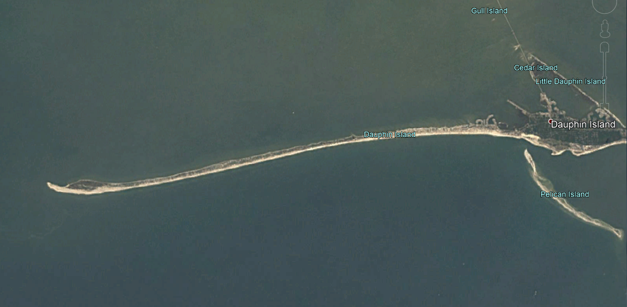
Dauphin Island 2008

Something similar nearly happened to Santa Rosa Island, though it did not get a permanant cut.
Notice the white section of this image, water flowed here for a couple of days as the water stuffed up into the bay emptied back into the Gulf.
My point? If Florence doesn’t become degraded, and hits with full force, expect some changes to the barrier island system along the Carolina coastline.
"A life-threatening storm surge is now highly likely along portions of the coastlines of South Carolina and North Carolina, and a Storm Surge Warning is in effect for a portion of this area. All interests from South Carolina into the mid-Atlantic region should complete preparations and follow any advice given by local officials."Hurricane Florence Discussion Number 51
Being a Gulf Coast resident, I can tell this bit since I’ve heard the tale myself. Anecdotally, the ONLY SURVIVOR from the Hurricane Party at the Richelieu Manor Apartments floated out the 3rd story window on a mattress. Every version I’ve heard state that the survivor as having been recovered from a tree several miles inland. (6 or 12 miles, depending on who tells it) How do you deal with something like that? Easy. DON’T BE THERE. Waveland Mississippi has been wiped off the map at least twice. (1969, 2005) People came back and rebuilt. In fact, the company that makes the accelerometers I use is based out of Waveland.
(Not a paid advertisement, I just like the product. If you are going to try and detect tiny motions, the x2-2 is the one you want. The device logs the info and you can just plug the device into a USB port and pull the data off. The computer sees it as a memory stick)
They also have a downloadable applet that allows you to configure the device while it’s plugged into your USB port. This is the thing I was using when I was trying to pick up a seismic signal from a land-falling storm last year. I think I may have picked up some wave action, but it was not a very strong storm and I’m 15 miles inland. I forgot that I had these things when Gordon was passing by, I could have measured the vibrations of my house as it went by. (They are 3 axis data loggers)
If you are poking around on Gurgle Urt and notice “Cat Island” to the west of Ship Island, the name comes from what the first French Explorers thought were cats. Probably misidentified Racoons. (They had no idea what trash bandits were)
Nothing really notable on the Surf City beach cam.
http://surfchex.com/cams/surf-city-pier-north/
So, here is a whole State launch page for Broadcastify, it might come in handy in a couple of days.
https://www.broadcastify.com/listen/stid/37
I thought I’d post this from NOAA.
Geo, what do you think the odds are once Florence is in the gulf stream that she may become a Cat 5 before landfall?
https://www.nhc.noaa.gov/graphics_at1.shtml?cone
First of all, I’m not an expert and am a poor source for prognostication.
Gut feel, unlikely. Maybe a four, but fives are actually pretty hard to maintain. From a storm’s point of view, everything has to be perfect and stay that way for a while to get up to that speed. Hurricane Andrew was only made a Cat-5 in the after event damage analysis. Andrew was a super tiny storm with a really tight eye that made it more closely resemble an oversized tornado than a full sized Hurricane like Camille. Tighter eyes are easier to spin up than large 30 mile wide eyes.
In Discussion 51, NHC noted that Florence had a period of ragged looking eye-wall but was able to re stabilize it. I went looking around for dry air pockets but couldn’t find any. I did note that on the 250mb winds, you could see Florence starting to feel the effects of that front that is out ahead of it. (Dry air + Hurricane = Seriously messed storm choking for fuel.)
This is probably that trough that NHC was talking about in Discussion 51. The red stream area in the US passing NE over Maine is the Jet Stream. Once Florence hits that it’s game over for her. Well, it will be game over for the storm before that, but the jet stream will shuttle what is left out towards the Icelandic Low like a bouncer showing a disorderly customer to the door.
So, while Florence looks quite nasty, it’s not a walk in the park for it. It’s still quite dangerous, but being a strong storm is a balancing act.
Seeing a small glow from the bottom of Fissure 8 using the new USGS webcam. Looks like it might have coughed out a bit of magma. (The fissure, not the web cam!).
Earlier, in an fully on topic comment, turtlebirdman stated:
“All these big numbers…”
Speaking of big numbers. The Law of Large numbers points to an event that has a non-zero probability eventually becoming manifest (or actually occurring) the more times you test for that condition. If you carry out infinite tests, you will “almost surely” find what you are looking for… eventually.
The Weather Channel™ is evidently pissed off that they missed Gordon’s landfall by hundred or so miles. They just stated that they have 18 crews in place to cover the arrival of Florence.
Now, looking at this from a detached point of view, they are putting the odds in their favor of loosing a news crew in the upcoming landfall. No doubt we will be treated to weeks of lamentations about their dedication to duty in the following weeks. I’m not saying it will happen, despite the idiocy, Homo Stultus is a remarkably resilient critter… but the Weather Channel is really trying to have something bad happen to their field reporters. Not to mention sending a hypocritical message to people who actually live there and have no real say in what sort of storms get thrown in their laps. “YOU REALLY MUST LEAVE” but we’ll sit here and gleefully report on your property getting destroyed.
It is insane.
Clearly their big numbers are related to ratings and ad revenue.
They would probably get even higher ratings and make even more money if one of their crews got whacked.
Plus, for insurance purposes, some actuary has even probably worked out the potential cost.
It just got downgraded to a cat 3. The Weather Channel™ is prolly in full crisis mode panic over storm downgrade.
Yeah, they are a perverse lot. But, there is still a 14 meter dome of water out there underneath it. It will take a bit for that to diminish.
And in the potential really bad section of the internet “EU approves controversial Copyright Directive, including internet ‘link tax’ and ‘upload filter’” https://www.theverge.com/2018/9/12/17849868/eu-internet-copyright-reform-article-11-13-approved
Link tax? Friken bureaucrats and their money grubbing schemes. How about a tree tax? Get done with your stint in office and you get to dangle out on a limb.
{Note, this comment might get deleted because I was not nice. Point of fact, after you screw with people enough, they tend to think of interesting things that can be done to you.}
It is not a ‘link’ tax. It is payment for showing a news story from a paper on another site, which is how google news works. Links are allowed, copying text is not. It won’t work anyway – google very rarely pays for what it shows. Article 13, which requires a copyright filter for images, may be more difficult.
Wheee! Yesterdays Florence.
no room for feelings in science…. “Just the facts, Ma’am” … but i’m sure ‘feeling’ Katrina and i don’t like it.
Well, Florence “felt” a gulp of dryer air. But do note that outer feederband next to the coast. Notice how it flared up as it crossed the Gulf Stream. That can pose a problem as it makes landfall.
In 1989, Hugo was a weakening storm as it approached the coast… then it hit the Gulf Stream and ramped back up in power.
This is the sort of storm that the wankers on TV were trying to make Sandy out to be. Sandy wasn’t anywhere near this league. This one’s the real deal. And to double the piss-off? According to multiple sources, Florence is going to nail the coast and stall for a couple of days. You get a tropical storm parked on top of you and the rainfall becomes epic. Reportedly this area is already near or above it’s record rainfall for the month… couple that with the storm surge blocking the flow of new water from the torrential rains, it’s going to get really nasty quite fast.
And a quote from Florida Highway Patrols standard book of slogans. When you encounter a flooded roadway, “Turn around, don’t drown.” And a personal hint from me, if you can’t see the asphalt in the water, it’s too deep to drive in.
I don’t know if it is gonna happen here or not, but in those epic floods in Jackson MS in the late 70’s, it was not uncommon for manhole covers to pop off. Find one of those open holes with your tire and you basically become stranded in a de-facto river.
Side note, if you are idling along in a flooded parking lot and your vehicle stalls from water getting in the tail-pipe… happy parking. Your car is an island now.
(Low gear and high revs lessen the chance of that occurring but if you back off the throttle, game over. Time to wade.)
This was actually what I meant when asking once Florence is in the gulf stream will she become a Cat 5, but that was when she was a Cat 4. What I should’ve asked was will she gain strength? I’ve seen it before.
What concerns me is now that she is downgraded, some people will pass it off as it’s not all the hype they report it to be. One of the problems with some of those reporting is caused by overdoing it to get people to watch them. :-/
And the situation just get more terrifying. According to National Hurricane Center’s Tropical Analysis and Forecast Branch twitter feed…
“Wave heights to 83 ft were measured early this morning under the NE quadrant of Hurricane Florence. These enormous waves are produced by being trapped along with very strong winds moving in the same direction the storm’s motion.”
https://twitter.com/NHC_TAFB
Now, remember these are open ocean waves/swells. They will probably be somewhat less as the eyewall makes land-fall, but the waves will be on top of the surge as it rolls in.
This just gives you an idea of how big a hammer Florence is carrying.
…and the apparent homicidal intent of sending a news crew to stand there and wait for it.
{Do it enough times, eventually you will find it}
Side note. Take this time to learn what a Pit Viper looks like. There is a pretty good chance you could run across one since they are also going to be forced to seek refuge. I don’t think the Carolinas have gators, but don’t be surprised at the number of critters that will come flooding out of the swamplands, quite angry that they were forced out into the open.
Alligators are native to to NC (and, presumable SC), though not in the same numbers as farther south. There is also an Alligator River and an Alligator River National Wildlife Refuge in Northeastern NC.
John Davidson’s house burned July 28, this is where the live feed was
https://www.facebook.com/photo.php?fbid=10156762959488474&set=pcb.10156762959523474&type=3&theater
I hated to hear that when it happened. They were so nice to let us watch it in the beginning. Now they need to learn to fly a helicopter to get to their home. I thought their home would be safe. It looked like they were high enough. I don’t know why I didn’t consider a grass fire.
Poor Rusty & his hens. Can’t see how they made it after all that happened. I have a rooster. When I hear him crow, I think of Rusty. 🙂
Update 54 states:
"Data from an Air Force Reserve hurricane hunter aircraft along with satellite imagery and various intensity estimates indicate that Florence has weakened instead of strengthening. However, while the hurricane hasn't strengthened in terms of peak winds, the inner-core and outer wind fields have continued to expand, resulting in an increase the cyclone's total energy, which will create a significant storm surge event."→ 500 PM EDT Wed Sep 12 2018
https://www.nhc.noaa.gov/text/refresh/MIATCDAT1+shtml/122042.shtml?
Current time is 2240 EDT.
Now, Honestly, I have NEVER been trained in reading weather in satellite imagery. To me, the latest satellite imagery seems to imply that the inner eye-wall is starting to contract a bit. If real and not just cloud debris filling it in, this could mean that it’s consolidating it’s flow and/or going through an eye-wall replacement cycle. The important thing to remember, I’m not trained in this field at all. I could be full of @#$@.
“As typical of previous studies, the outer rain bands (see graphic below) are most electrically-active, but lightning in the eyewall can be an indicator of intensification.”
https://www.forbes.com/sites/marshallshepherd/2018/09/12/the-meteorological-strangeness-of-hurricane-florence/#527076e2782c
And poking around on Lightningmaps.org I am not seeing lightning activity in the eyewall. Doesn’t mean that nothing is happening, but lightning there is supposed to point towards intensification.
In the Forbes article, several lines of text express amazement at Florence being so strong so far north. I guess they forgot about 1954’s Hurricane Hazel that actually made landfall in North Carolina as a full on Cat-4.
Approximately 980mb at landfall according to this chart. Previously, it had carried 130mph winds at 938mb. (Not sure if that was while it was in the Caribbean or not, I don’t feel like dragging out the HURDAT file to find out.) Evidently, that same year, Edna did a rip-snorter up the coast and did not drop back below major hurricane strength until it passed New York.
Alright…. I went and looked. It seems that his claim is dubious at best.
939 mb at 50.8°N seems to refute that claim. That’s a lower pressure and a higher Latitude. Though it may have been an extratropical system tangling with a front and becoming a Nor’Easter.
Some unrest at Iwo Jima
https://www.japantimes.co.jp/news/2018/09/13/national/undersea-eruption-detected-iwo-jima-seawater-sent-flying/#.W5pHTkZKiUk
Carl should be publishing something on the subject shortly.
There is some lava in pu’u 8 again.
This might have been posted before. Some good drone and air video with some discussion on the eruption.
http://www.bigislandvideonews.com/2018/09/10/video-whats-going-on-at-kilauea/
Another new video. Talk about the size of the collapse.
http://www.bigislandvideonews.com/2018/09/12/video-hawaii-volcano-update-summit-collapse-perspectives/
Katla nearing an eruption
Massive amounts of Co2 and other gases detected
https://icelandmag.is/article/new-study-confirms-monster-volcano-katla-charging-eruption
Which goes first?
Katla, Hekla, Oraefajokull, Grimsvotn or Askja?
Concerning Surrey, once I was in a boat with some locals and we got a bit near the island. But we didn’t set foot on it. I am sure it’s easy for locals to do it if they wish. So I am not surprised that potatoes were once found there.
Katla will certainly erupt at some point. CO2 is a sign of magma, a few kilometers below the surface (where the CO2 comes out of solution). So it does not imply an impending eruption, just that magma is accumulating. The study also has not shown that CO2 is increasing, and neither is it clear that what they measure is a typical value: it may have been released with summer ice melt. More study is needed.
Yes and that’s an important point. CO2 is the gas most easily released from magma; it can come out of solution at depth, from a magma body that isn’t near eruptible, and filter easily to the surface. SO2 is more significant for a warning; a significant rise in SO2 flux, along with other signals of course, would be much more noteworthy. Still, that IS a massive amount of CO2 – which must say something about the size of Katla’s magma reservoir.
SO2 has also been detected often in the past years. So there is magma near the surface. Which explains many shallow M3 quakes. In fact it most likely already erupted (a tiny bit) in July 2011. But this is disputed.
Katla chamber is a large and shallow one, and it seems to hold a lot of magma until a proper eruption occurs.
Yes, Surrey (UK) is a dodgy place! As a resident of Reigate, I can attest to the local conditions: choked traffic (think: the M25), regular flights from Gatwick Airport passing over, expensive shops, and regular earthquakes from the fracking drills at Newdigate, down the road. No volcanoes though. Well…not yet.
Apologies – just having some fun at the expense of your typo/autocorrect for Surtsey! 🙂
Didn’t Monty Python suggest that Reigate was in Mozambique? It might have been in the ‘Colin Bomber Harris wrestling himself’ sketch.
“34 miles off the coast of Cape Fear, North Carolina”
https://explore.org/livecams/frying-pan/frying-pan-cam
Warning, currently VERY LOUD
IMO reports M 4.1 at Bresteinsfjöll,
4,6 km depth.
OT (again), but I was musing at an “in the field” reporter on the news earlier clinging to a lamp-post as he made his report live from Morehead City NC. He thought he was okay, but you could tell the lamp-post was getting hammered by the winds and was visibly whipping back and forth. I certainly hope he has retreated to shelter, according to Nexrad, Morehead is catching 105kt+ winds pretty soon (at that elevation).
Working out the slant range equation, that blue patch is between 500 and 1000 feet altitude. That’s between 124 to 130% of the ground speed (10 meters). Compensating for that, your looking at around 80 to 85 kt winds when that area crosses Morehead.
Despite the presence of the Gulf Stream, it does not appear to be gaining strength, (got a few other things impeding that) but does seem to be maintaining strength longer than most storms this close to the coast. BTW, from what Nexrad is showing… it’s starting to track down the coast.
Phil and John did another kilauea update today. It won’t let me save the link for some reason but it’s on Phil’s facebook page.
They have a very interesting take on the deep quakes at Pahala being horizontal fault lines extending from kilauea (and probably mauna loa) within the lower lithosphere rather than the true conduit from the mantle which they interpret as being mostly vertical. The quakes in their model are related to increasing pressurization of the lower magma system as magma continues to move into the system at a high rate that it was before, enough that an eruption big enough to qualify as VEI 4 could happen within a year. This of course means that an eruption is very likely within the next year with the already only very limited storage space at the summit being completely compromised. Both are also now comparing this years events to 1790, and in fact are basically saying the same sort of things I and others here have been saying for a few months so it’s pretty cool to be getting support from people with qualifications 😀
Regardless, it seems like things are far from over there, though the inhabited areas might get a break for a while.
It might be important to find the timescales that it would take for the water table to intrude into the conduit, if that is likely to take years then the summit will probably be safe but if it only takes a few months then it is likely to occur before the next eruption and the park should be very carefully opened… If someone can find out how hot the rock at the bottom of halemaumau is then that is a good start.
How’s this, turtlebirdman?
https://www.facebook.com/phil.hawaii/videos/10216185299167220/
Yep
Not the easiest to listen to – it is long winded. Their interpretation of Pahala can be argued with, but basically we just don’t know. There is clearly a distinct deep cluster there, not just the end of a rift. There is little evidence of a magma chamber (because of a lack of a surface feature) but the area started some years ago and build up as Pu’u’Oo declined and the summit inflated – it is related to the summit supply. Sadly there is no GPS in that area. The nearest I could find shows no sign of long-term inflation.
Regarding 1790, yes, that is now the closest analogy. Not identical though.
Their explanation of the pahala swarm is consistent with all the observations too, and actually makes sense with the location of kilauea too. There is no pronounced horizontal magma pathway under any of the other volcanoes and they tend to occur in fairly predictable locations so it wouldn’t make sense for kilauea to source magma from between mauna loa and loihi when its magma composition doesn’t really support that. Anyway the pahala swarm is as far underground as Pahala is from kilaueas caldera, so there would be no surface expression of anything there anyway. Maybe some of kilaueas magma comes from under there but the majority evidently comes from more directly underneath it where there is a silent zone. In any case the area is responding to magma rising from depth towards kilauea, probably at an elevated rate after the massive drain changed all the stress fields. Opening the park was a necessary but really dangerous decision, kilauea is not the safe effusive volcano it was 5 months ago anymore.
1790 is indeed not identical, this event is significantly bigger…
It also might not be over yet as the rift isn’t inactive like would be expected, there will be some more to come there but that might be after summit activity, sort of an amped up version of 1955 – 1959/1960.
Note that the Pahala swarm is very long lasting (years), focussed in a very small area and at a uniform depth. That needs to be explained. It can’t be magma flowing through a fault, as flowing magma gives no earthquakes. Something must be changing. It is not fault slippage because it lasts too long and is too spatially confined for that. The most likely cause is an inflating magma chamber. Where the magma comes from is a bit irrelevant. It could be anywhere underneath the island or ocean: all that we know is that it found a way here which may not have existed before. The facebook video made some attempt at identifying gaps in the earthquakes but in the Pahala region this was unconvincing. The human eye always has a tendency to see patterns in a few dots, and you have to be aware of that. (The gap underneath Kilauea looked more convincing but it still needs to be tested for statistical significance.) If there magma growth, there will be inflation. But that may well have been missed: this area seems devoid of instruments. The nearest ones are too close to the big gorillas Mauna Loa and Kilauea.
I was wondering about the connection between the summit and the rift zone. Sure, depth of the crater plays a strong role in where magma goes. But Kilauea is not actually on the rift zone. The rift is displaced to the south. The weak point in the chain is the connection between Kilauea and the rift, roughly the stretch summit-Mauna Ulu. If that blocks, the rift starves, and I think that is what happened in August. The block may or may not last. The rift clearly does not have its own magma supply: everything is sourced from the summit, although some can be stored in the rift for a long time. Once this eruption is history, there will not be further rift activity unless the connection re-opens. That is not impossible: the deflation ended just when the summit was poised for another collapse and that stress may still be there: there could be one more collapse.
Albert, the explanation I’ve read from an HVO person (can’t recall exactly where) is that their interpretation of the deep Pahala seismicity is that it is an expression of a *bend* in the deep feeder conduit, where it goes from more vertical, to a sub-horizontal feeder towards Kilauea.
That kinda makes sense to me; it reminds me of the PAUD station which was often very ‘noisy’ with low-grade seismicity – and it coincided with a distinct bend in the conduit from Kilauea to the LERZ.
You would have a far better idea than I of the physics that might explain *why* a bend in a conduit should be ‘noisy’! 🙂
Cavitation?
I read once that there is a low seismic velocity anomaly at the depth of the Pahala swarm that extends from underneath Kilauea to the south offshore, so there is a chance that Loihi and Kilauea share that magma source. There was another anomaly under Mauna Loa at a similar depth but I remeber that the publication wasn’t very clear about if it was also connected to the one under Kilauea or not. The publication did propose that the area south of Kilauea was the current location of the hot spot.
Yes, the strecht summit-Mauna Ulu is clearly the weak point of the rift, an area of much lower volcanic activity and dikes also intrude oblique to it instead of along it. But I am not so sure about a blockage forming in August.
The years before 1790 were characterized by very high ERZ activity, including a Pu’u’o’o like eruption, though smaller, and multiple probably short-lived erutions ocurring along the rift, some of the resulting flows dated in <200 years BP and a vegetation similar to that of the 1790 and Heiheiahulu lavas suggest that these eruptions indeed happened close in time to the 1790 eruption and represent a phase of ERZ activity though less voluminous than the one we are currently in. So the question is what ended that phase of east rift activity and cause the eruptions to return to the summit by 1790 and remain there (and in the SRWZ) until 1840. As I have said in other comments there are four pit craters in the ERZ that by the beginning of the 20th century had no lava in them except for the inner Alae pit which had 1840 lavas. These craters then seem to be more recent than the ERZ eruptions of the ~second half of the 18th century and older than 1840 all o them are located on the upper east rift and two are in the summit-Mauna Ulu strecht. I think the pit craters must represent an event that drained the rift zone and caused the collapse of the existing upper ERZ magma reservoirs and is to blame for the end of activity as it closed the rift until it opened back in 1832-1840 causing the summit eruption rate that was at that time of 0.3 km³/year if I remember correctly, to drop to very low levels. The same hasn't happened this time, no collapse has formed that would indicate that the upper ERZ has been drained out during this year's eruption and the Pu'u'o'o collapse did not impede transfer of magma between the summit and the LERZ. The eruption did end surprisingly abruptly I dont know what might have caused that. If there is a connection summit-ERZ or not right now is probably going to be what decides what will come in the next decades. If the rift zone is not done yet, which I think to be the case then it is likely that there will be more caldera-formation collapses in the future. The new caldera is very small, I really dont think it is near as big as the collapse in 1790 but the problem is that it is difficult to know what formed in 1790 and what before that, what it is sure is that all of the ring faults in the new collapse were located within the boundaries of the caldera while some of the prehistoric collapses involved much more larger areas, with ring faults forming more than 1 km away of the caldera rim and causing very large areas to subside a few meters. This year's collapse is small and I dont think there is a high chance that it will lead to explosive activity, even if a lake forms it will be very small, no more than 0.5 km² in area so it is not very likely that the eruption will come out from that exact point.
All this noise could indeed be directly related to the next round of activity, or the next significant activity could happen with much less advanced notice. Time will tell.
The main thing to keep in mind, IMO, is that however it happens, overall there is a strong likelihood that Kilauea (and Mauna Loa) will vigorously erupt again at some point. Possibly (probably) more vigorously than anything that has ever been witnessed and documented by humans. The consequences of such an eruption would obviously be dangerous and dramatic locally. However, I would argue that the more significant impacts of such an event would be related to the SO2 output from such an event which could be quite far reaching.
Thedustdevil
I agree with your assessment that there is evidence of significant activity shortly before “actual calendar year 1790” and also between roughly “actual calendar year 1790” and 1840.
I keep saying this but it is still true.
1. The eruption volumes in Hawaii before 1840 are rough guesses and cannot possibly accurately account for the mass of lava that entered the ocean.
2. The dates are also best guesses in many cases. Radio carbon dating lava is not particularity reliable. Also, until the mid-1800’s this part of Hawaii really was just about the end of the earth and detailed formal records are sketchy, at best. Even now, Kilauea is still pretty remote and even most Hawaiians have never actually been to the volcano. Kilauea is 200 miles from Honolulu on the other side of Mauna Loa. This area would have been extraordinarily difficult to get to back then with no water or food for miles and, additionally, if it was during a significant eruptive period, the whole area around the eruption would have been blazing hot and covered in a choking vog.
It is true that the volumes for most prehistoric eruptions are just guesses because most of the ones that are exposed are only partially exposed in the surface which is covered by younger lavas, also many of them included ocean entries which mean that through lava delta collapses or underwater flows volume might have been lost to the sea. The volume erupted after the 1823 SWRZ eruption and until 1840 is more or less well known, activity was rectricted to the summit area and is estimated from the volume of the caldera that was filled during that period, including the collapses of 1823 and 1832. I think the eruption rate at least at some point during that period was of 0.3 km³, which is quite high for Kilauea.
Knowing the volume erupted in the years before 1790 is quite difficult but I think it is more or less safe to say that it is smaller than the one erupted during this phase of ERZ activity (1955-now and maybe to continue), the difference in the eruptions size is really big. The most voluminous ERZ eruptions tend to be the shield-building sustained ones, we have had two of those since 1955, Mauna Ulu and Pu’u’o’o. Pu’u’o’o clearly outdoes the only sutained eruption of the years before 1790 (Heiheiahulu) there is a really big difference in the areal extent of the two flowfields, Pu’u’o’o’s shield is also higher and has a way bigger summit pit (if that can be used as a way to measure the size of eruption). The other eruptions that add a significant volume are big LERZ eruptions, so it is 2018 vs the 1790 double fissure, I think turtlebirdman has already estimated several times the 1790 eruption to be smaller than this year’s and I would agree that it seems that way. For the other eruptions of the 18th century, all of them have small extension (similar to the 0.08 km³ 1955 eruption for the bigest ones) and few reach the shore.
So back from what you wrote above..
1 The chain of pit craters you are talking about are the features that run from roughly Devil’s Throat to Makaopuhi?
2. Are you saying that these features appear to have been the result of activity after 1790 prior to 1932?
If so, how significant might the activity have been that created these features?
The chain of craters is formed by at least 15 collapse craters some of which overlap creating complex craters and suggesting that the pit craters have different ages. I do not include Devil’s Throat with the other pit craters cause it is considerably smaller than the other ones and also is more similar to small pits that are found in the SWRZ. I was also counting as ERZ pit craters Keanakakoi, Luamanu and Puhimau that are near the summit caldera rim and within the ring fault complex. All of the pit craters are more recent than the Kane Nui o Hamo eruption which unfortunately is not dated but must have happened somewhere between 1300-600 years ago. The pit craters formed in at least 2 different collapse events and I think the bigger Makaopuhi pit is older than the other two events. The four most recent looking pit craters: Puhimau, West Pauahi, Inner Alae and West Makaopuhi seem to have formed somewhere after the eruptions that happened roughly during 1750-1790 and before 1840. This could have great significance because it might give a clue of why activity rapidly changes from east rift activity to summit activity which is something that happened in 1790. From testimonies a LERZ eruption happened in 1790 culminating a period of intense ERZ activity and then also in 1790 an explosive eruption happened in the summit and was followed by a period of very high summit activity that lasted until 1840. My interpretation is that the 1790 fissure eruption drained the ERZ of magma causing four magma reservoirs in the upper rift to collapse, closed the rift and opened a period of summit activity.
Mike, I had to try to visualize this. Dykes can’t have sudden bends as the pressure in a moving fluid can’t get an equilibrium, and deep underground that means that the bend will tend to collapse. Gentle curves are easier, but the best way to change direction is through a near-stationary magma chamber. You get such a chamber if this is the depth at which the driving overpressure from below reaches equilibrium. This slows the magma, and slower magma will form a reservoir.
Why would it go off in a different direction? Magma will always follow the path of least resistance. That is the direction in which it is easiest to push the rock sides apart. In a spreading centre, that direction is along the rift (e.g. Bardarbunga). Underneath a caldera, that direction is (strange but true) horizontal, and this gives the horizontal sills where magma collects (since the Kilauea collapse, this will be happening there) . Along the slope of Hawaii, the direction will follow that slope. From Pahala, that is towards Mauna Loa. However, the fault plane along the southern side of Hawaii may provide an alternative path, one that goes more towards Kilauea.
Something happened a few years ago at Pahala. Perhaps [speculation alert], an increase in magma driving pressure pushed the magma chamber a bit upward. It found the fault plane, and began to feed towards Kilauea. It acquired a second magma source and the overlook crater began to form. As pressure in Kilauea increased, it slightly pushed the fault plane allowing the magma to flow more easily.
The earthquakes form in rock, so something is moving/breaking/changing. I would guess it is the upward pressure in the magma reservoir.
I don’t see how Pahala can feed Loiihi. The angles seem wrong. Mauna Loa would seem the natural destination, and Kilauea in special circumstances.
It appears that there are 3 periods in the Greenland ice sheet showing elevated levels of SO4 that overlap the period of activity you are describing (post-1790 to 1840) that do not really fit any other known eruptions.
1810-1811
1832
1836
You mentioned earlier that the eruption rate was 0.3 km³ at some point in the 1832-to 1840 period. How much magma erupted in the 1830’s in total?
The aproximate erupted volume from 1823 to 1840 was of 3.5 km³, calculated from caldera filling rates cause I couldn´t find the total volume value. The rate was at its peak of 0.32 km³ right after the 1823 collapse which was caused by intrusion and eruption in the SWRZ, then it lowered but to peak again after the 1832 collapse caused by another intrusion but that remains unclear where. Interestingly the 1840 collapse caused by an intrusion and eruption in the ERZ did exactly the opposite to the other two and caused a drop in the summit caldera filling rate that since then has remained at or lower than 0.05 km³. The rates of erupted lava could be assumed to have been similar or higher from 1790 to 1823 a period that even included one explosive eruption and high fountaining events.
Kilauea was very active during that period but a large explosive eruption that reached stratosphere should be responsible for the high SO4 levels in Greenland ice and the last explosive eruption of Kilauea happened in 1790, after there was high effusive activity but that shouldn’t have sent any SO2 into the stratosphere.
The rates of 1790-1823 similar to 1823-1840 I mean.
I am working on an analysis that attempts to refute that idea wrt to the SO2 from Hawaii eruptions. I have found 3 separate examples that I think show that there have been plume interactions with upper level (Jet stream level) winds at 250mb to 300mb ASL altitudes from Hawaii eruptions.
Example 1: Mauna Loa 1984
This is actually at least one confirmed and documented eruption in Hawaii that easily topped the 10km ASL altitude. Mauna Loa 1984 was estimated at 11km. There may be more examples in HVO records, but I have no means of searching that. If the tiny blip of an eruption at Mauna Loa (by historical Mauna Loa standards) in 1984 topped 11km, then it is literally impossible that other more energetic activity at both Mauna Loa and Kilauea did not reach at least those types of UT/LS altitudes.
Example 2: The 1924 Kilauea eruption
”The larger explosion clouds reached several kilometers high, with an maximum of 9 km (about 5.5 mi) estimated by Ruy Finch of HVO. Trade winds were blowing from the northeast during the eruption, yet wet ash fell at least once on railroad tracks in lower Puna, northeast of Halema‘uma‘u. This is consistent with the ash cloud rising about 5 km (3 mi) or more into the jet stream wind, which blows from the west. Gutters on the roof of a store in Glenwood, 16 km (10 mi) northeast of Halema‘uma‘u, collapsed from the weight of muddy ash, also suggestive of jet-stream transport.”
Example 3: The Kilauea May 17,2018 Explosion
HVO reported one event from May 17th that reached 30,000 feet and “Drifted to the North East”. Again if this minor activity reached that level, then many others must have.
I just sent my latest version of the analysis to Gaz.
The way kilauea seems to behave is through a roughly 300 year cycle. The cycle starts with a deep caldera, initially with vigorous and often violent eruptions that can be phreatomagmatic but then with more passive effusion as wider and more stable conduits evolve. This activity is increasingly vigorous and fills the deep caldera rapidly and in some cases may overflow completely, as happened in the medieval. Then a distal rift eruption drains the system at a deep level and ends this period of intense summit activity. In 1840 this also seems to have coincided with a significant portion of the hotspot diverting to mauna loa, which abruptly entered a period of frequent eruptions after maybe erupting 3 times in the century before that (much like now). This is probably the reason for the sudden sharp drop as much as the natural cycle.
After a period of extreme summit activity lasting decades to centuries things slow down a lot, eruptions still happen continuously because of existing open conduits but if anything disturbs this it doesn’t resume, 1924 was a possibly unexpected large intrusion during a period of low activity, had that not occurred then the lava lake probably would have stayed until 1952 when activity started ramping up again.
When activity increases again it seems to go into the rifts more initially, first as individual intrusions but then as a single conduit forms in the rift new intrusions just branch from that and eventually a single large eruptions occurs that lasts for decades and builds a shield with a volume of between 3 and 15 km3, pu’u o’o was on the larger end. This ends with one or maybe several large distal eruptions in the LERZ that drain out the rift conduit and the summit. This is where we are now, in the period of uncertainty at the very end of a cycle. The summit has collapsed but the east rift hasn’t become inactive, there is likely to be more activity there in the short term, possibly as another very big eruption.
The interesting thing about this situation is what happens next. Alberts idea on the pahala quakes as magma moving along faults into kilauea when normally the area would feed mauna loa could have massive implications. That magma could have been magma destined for mauna loa to cause an eruptive period there, but instead it now feeds kilauea. This is maybe why this eruption was way bigger than any other eruption in the past few hundred years. This also could be an indication of a large reactivation, maybe instead of the caldera filling like in 1790 it might just completely overflow in another observatory/aila’au type eruptive series. That might be a fair way off though, probably a decade at least. The next eruption will probably be continued small activity on fissure 8, and then as new magma moves into the summit the rift might become more active and a new distal eruption like 1960 could drain it out and cause the sort of collapses that would make pit craters in the chain of craters area. Before this happens though there could be some eruptions at the summit.
Caldera collapse and very large distal eruptions/eruptions (~1790) > Caldera filling (1790-1840) >
‘Smaller’ distal eruption (1840) >
Slower caldera filling (1840-1924) >
Resumption of vigorous activity (1952) >
Dominantly rift eruptions (1955 – 2018) >
Shield eruption (1983 – 2018) >
Caldera eruption and very large distal eruption/eruptions (2018 – ?) >
Turns out there is an abundance of physical evidence of significant activity at Kilauea between “1790” and 1823.
SWANSON, Donald A., Hawaiian Volcano Observarory, U.S. Geological Survey, PO Box 51, Hawaii National Park, HI 96818, BIASS, Sebastien, University of Hawai’i, Honolulu, HI and GARCIA, Michael O., Department of Geology and Geophysics, University of Hawaiʻi at Mānoa, Honolulu, HI 96822, donswan@usgs.gov
Kīlauea was almost exclusively explosive (mostly phreatic and phreatomagmatic) for about 300 years ending in the early 19th century. How did that long explosive period give way to the present dominantly effusive period?
A widespread assumption is that the golden pumice of Sharp et al. (1987), the product of one or more high lava fountains, represents a transition between the two periods. It is preserved mainly west of the caldera (an unusual dispersal direction given prevailing N and NE trade winds), where it rests on lithic fall and surge deposits of the lethal 1790 eruption. In 1823, Ellis noted the golden pumice near Kīlauea summit. No tephra overlies it, so modern workers assumed that the golden pumice is the only post-1790 explosive deposit of the 19th century.
This assumption is wrong. We recently found that at least six other explosive eruptions took place after 1790, starting with a fall of pumice and achneliths (together called the eastern pumice) and followed successively by falls of fine lithic ash, Pele’s hair, lithic lapilli, inversely size-graded mixed vitric and lithic ash and fine lapilli, and lithic blocks and lapilli. This tephra was deposited mainly south of the caldera, a common dispersal direction that is very different from that of the golden pumice. Until recently, no outcrop was known to include both the golden pumice and the other six deposits.
In September 2016, we discovered an exposure just SSW of the caldera in which the golden pumice clearly underlies the six other explosive deposits. Several centimeters of alluvium separate the golden pumice from the eastern pumice and the younger fall deposits. From previous work, the golden and eastern pumice are chemically distinct, and microbeam analyses of pumice samples from below and above the alluvium match those of the golden and eastern pumice, respectively.
Thus the golden pumice clearly belongs to the Keanakāko‘i explosive period and does not record a transition to the current effusive period. Instead, the Keanakāko‘i ended with lithic-rich phreatomagmatic and phreatic eruptions younger than the golden pumice, not with a high lava fountain. We speculate that the change from explosive to effusive activity took place rapidly (a few years or less?) as the magma supply rate increased, keeping the feeding conduit full and impeding involvement with groundwater.
Handouts
GSA Cordilleran Honolulu 2017.pptx (18.7 MB)
Please do quote sources (you say who it is from but not where published). I noted that this is from https://gsa.confex.com/gsa/2017CD/webprogram/Paper292369.html
Yes, Kilauea was active during 1790-1840, it is a fact, when William Ellis arrived to the volcano in 1823 he found more than fifty spatter cones of which half of them were active at that time and flows of lava rapidly filling the crater left by the 1823 collapse that had happened just a few months earlier during a eruption in the Seismic SWRZ he was also told about from the natives, the Keaiwa eruption. But I do not like that explosive and effusive periods view that HVO currently has, the thing is that to identify the periods of low effusive activity they used radiocarbon dated flows and it turns out that practicaly all dated flows are from summit overflows. They do say in the publication about Kilauea’s cycles that the LERZ is underrepresented, they said this because they did not include Heiheiahulu and the 1790 flows which of course are thought to fall within one of those explosive periods. But the whole ERZ is underrepresented, from what has been observed in the historical period when the ERZ is erupting, the summit is more or less quiet, and also the other way around. So if you put all the dated flows in a graph you are going to get gaps in those periods where the ERZ was under intense EFFUSIVE activity. Another type of effusive activity it was not considered is the caldera filling eruptions which historically in Kilauea were continuous for more that a century and didn´t manage to overflow so that they might be an long important part of Kilauea’s eruptive history and of course are not dated. From what we know and the things learned during the Leilani eruption it is the ERZ that causes the summit collapses that would trigger summit explosion events and then you have that when the ERZ goes quiet and there is still a summit caldera what you get is a caldera filling period so you do not only get a not-likely-real gap in effusive activity but it is also going to coincide with the explosive events. 1000-1500 was a period of continuous summit overflows while 500-1000 was very probably a period of ERZ activity alternated with caldera filling and maybe some short small overflows. And where are we right now?, well currently we would be in one of those “explosive” periods.
If someone wants to read the publication where the cycles of explosive and effusive activity are defended it is here: https://www.soest.hawaii.edu/GG/FACULTY/garcia/publications/Swanson%20et%20al._2014_Kilauea_Explosiveness.pdf
Kilauea is a volcano with explosive eruptions but I oppose the idea that those events happen during periods of low magma supply and low effusive activity, this also something that hasnt been observed in other basaltic volcanoes, as they mention.
The one thing I don’t get is that 1790 was obviously not a result of static magma interaction, there are lava flows from ring faults to the southwest that are within the 1790 explosive deposits, and that means magma was actively pushing up. These flank vents were quite small and probably brief but also much higher elevation, the 1790 main vents were probably very powerful eruptions that would have been high fountains if it was dry.
I’m also very confused why there is no real objection to aila’au being the cause of the caldera collapse, that is not how gravity works. Pu’u o’o is about the same size as aila’au (actually it is very likely much bigger) and at lower elevation but no collapses happened. The collapse did happen, very quickly, when this years LERZ eruption really took off. That alone says enough. Coincidently there also happens to be a very big LERZ flow around the same time the last caldera formed in the late 18th century, and another around 1500. Also ‘just by coincidence’ each of these eruptions occurs some short distance in time after a lava shield formed on the rift zone. Two of these shields even happened in basically the same spot, and 3 such shields were formed between 1986 and 2018.
The aila’au vent seems to have been the victim rather than the perpetrator, only plinian eruptions are able to undergo caldera events through a vent at high elevation because the degassing is happening at depth, Hawaiian eruptions need a full magma supply up to near the surface because the degassing occurs near the surface. Kilauea has done plinian eruptions before but not in 1500. I’m confused as to why this simple physics seems to just fly over everyone at HVO, you can’t drain a water tank by making it overflow. However you can drain it very effectively by blowing a massive hole in the side…
Beyond basic physics flying right over them …..even actual clouds fly right over their very own eyes at HVO.
The official report from the 1984 Mauna Loa eruption reads:
“There was no evidence that the plume reached the stratosphere; the tropopause on 25 March was at about 18 km altitude. The plume was carried W by trade winds.”
….hmmmmmm
I don´t understand either how everyone in HVO seems to agree in that Aila’au was responsible for the formation of the summit caldera, the well understood historical summit collapses (1823, 1840 and 1924) have been caused by either ERZ or Seismic SWRZ intrusions events, the 1868 collapse happened during the Ka’u earthquake and there was also a rift intrusion so the situation gets complex, and of 1832 few is known. All historical evidence points to large amounts of magma intruding the rift zones being the cause of summit collapses and yet they came up with the idea that it was a summit eruption the one that caused the caldera to form, not to mention that Aila’au was one of the summit vents, meaning that it was located almost above the main magma reservoir and the summit erupts only as long as that reservoir is inflated. That is the reason why the summit doesn´t produce fast voluminous eruptions as the rift zones do, the eruption rate has to be similar or less than the supply rate to the system or the magma chamber won’t be able to build up enough pressure to send magma upwards. There also turns out that in the LERZ there is an extensive aa flows eruption and a Heiheiahulu-like event dated very close to the presumed caldera formation in 1500, have they even considered that option? It is like if lately HVO has only been focused on studying summit overflows and explosive eruptions while the rest of Kilauea’s eruptive history has been left out. Even though we were in the middle of the Pu’u’o’o eruption and Kane Nui O Hamo is the closest thing to Pu’u’o’o we still know the same it was known about it in 1980.
Plus, they always mark a hard line at the point where Mauna Loa ends and Kilauea begins as if the Mauna Loa lava knows this rule and exactly where to stop.
Not sure about a case specifically for Aila’au, but in reality, there is literally ZERO chance that the flows over Kilauea and resulting mass that is currently attributed to Kilauea is not actually a combination of flows from both volcanoes.
In particular, the bit of orange that knew to stop just above the Kīlauea summit which is estimated to have occurred at between 118 to 1000 YBP.
Current weather map from weather channel. Florence knocking on Wilmington’s door.
https://weather.com/weather/radar/interactive/l/USNC0760:1:US
Yeah, watching the reporters interviewing themselves.
Not hoping for any thing bad to happen to them, but I would not be surprised if one of them got smacked with debris.
You know it’s coming.
https://www.myrtlebeachonline.com/news/local/crime/article218179765.html
Sure enough, a resident told one of the reporters that looters are out and about, and reportedly at least one was arrested yesterday.
I think they ought to just give looters a john-boat and set them adrift in the storm.
39″ of rain in some points. I think they have a mess.
Storm is crawling down the coast at about 4 mph… and, as is common in all of them, they act as moisture pumps and keep dragging more rain ashore. The messed up part of this storm is that the onshore wind is hitting during and after the deluge and blocks the water from flowing back to the ocean. Northbound storms at least lessen the waterway blockage and sort of pull the water back out after they pass.
Surfing with a parasail- in a hurricane.
Surfer’s name was Darwin McStultis…
https://twitter.com/i/status/1040392219872645121
{Grin}… I like the name 😀 Good one!
Though honestly? I wouldn’t be surprised if it were one of my cousins.
The character “Hank” from the animated program King of the Hill would state; “That boy ain’t right.” Though in reality, I don’t have room to talk. The day before I went to boot camp, my friends and I were quail hunting in a soybean field. We would take turns being the dog. As soon as you heard the birds take flight, you dive to the ground so that the shooter could get a clear shot.
It looks like the eye wall is staying just on shore as it drifts south. That has got to be eating up the shore line even at a cat 1. With all the extreme rain trees must be dropping. When it finally drifts inland it is going to drag all the rain (40 inches) slowly with it.
Incoming star for Bárðarbunga. The automatic system seems to be a bit confused about this one, so at the moment it only has 50% accuracy and does not show up as a star, but the waveform is there on the drumplots so it will probably become a star once it is manually verified.
Verified as an M4.2.
Fits your model?
Yes. It’s a bit on the small side, so don’t be surprised if something between M4.5 and M5 pops up in the next few weeks.
Super Typhoon Manghut
3 hour wind gust total projected for about now
Sorry here we are
A short time ago CNN spoke to James Reynolds in Santa Ana in the peak wind area. He said it is very, very bad.
Phillippines official current storm surge warning
http://bagong.pagasa.dost.gov.ph/tropical-cyclone/forecast-storm-surge
Live Radar http://bagong.pagasa.dost.gov.ph/
It is also heading for Hong Kong. When I was there earlier this year, sea water was several degrees warmer than usual. It was unusually dry, but with an expectation that there could be interesting weather in the summer.
Estimated landfall intensity looks to be in the region of 900 mb and 155 knots.
That’s the recent actual Philippines landfall estimate for Super Typhoon Mangkhut – not projected Hong Kong area landfall just to be clear.
Landfall
Isaac’s spaghetti models are driving me bonkers right now!
Refer to the last discussion about it. According to the instruments, it has fallen below TD level winds and is being downgraded to an open wave. They think it might reform in the Western Caribbean, but for the most part, it’s petered out. Being a wave rather than a closed circulation system, it is really hard to state any specific position for it.
Personally, I’m quite happy with that. Issac was the one that had me worried. (Similar track to Ivan 2004.) It still bears watching closely though, Camille 1969 formed from a Cape Verde wave once it got into favorable waters. Then it transitioned into a monster while riding due north over a warm eddy current all the way to the coast.
Isaac has rapidly lost organization since the last advisory. The cyclone has been devoid of any deep convection for most of the evening, with only a small burst recently forming well to the west of where Isaac's low-level center is believed to be located....
The global models continue to insist that Isaac could open into a trough at any time, and based on the current state of the cyclone, this could be imminent.
...
It has been very difficult to try to pinpoint a low-level center of Isaac over the past few hours, but based on microwave data it appears to still be moving west at about 13 kt. The GFS and ECMWF are in very good agreement and show Isaac, or its remnants, moving steadily westward for the next several days. The regional models on the other hand show a farther north motion, in part due to one or more reformations of the center.
https://www.nhc.noaa.gov/text/refresh/MIATCDAT4+shtml/150238.shtml?
Thanks, I shouldn’t look at the “strings” before I go to bed, got myself all worked up 😀
No communications with highly experienced storm reporter James Reynolds in Santa Ana (who is reporting this storm for CNN) now for over 14 hours. The last voice report said that the supposedly safe hotel they were staying in was being devastated. Last tweet was
https://twitter.com/EarthUncutTV/status/1040686656976650240
James Reynolds
Verified account @EarthUncutTV
14 hours ago
Losing data – interior of hotel trashed, window and doors blown in. #typhoon #Mangkhut #Philippines
=====
Last live CNN report from about 16 hours ago.
https://edition.cnn.com/videos/weather/2018/09/14/super-typhoon-mangkhut-philippines-gorani-reynolds-bpr-hgt-vpx.cnn
He’s okay at least
James Reynolds
Verified account @EarthUncutTV
13 minutes ago
Beast of a #typhoon – Santa Ana slammed hard, locals saying worst they’ve ever seen. Hotel windows and doors exploded in but we’re all safe – electricity and cell signal all out #Philippines #Mangkhut #OmpongPH
Wow, the Philippines are regularly hammered, but you don’t see idiot reporters out on the beach there, These are relatively low volcanic islands and the storm surge goes miles inland. The East Coast of the US is ancient bedrock shielded by the coastal plains and barrier islands; and they don’t call them “barrier islands” for nothing. While storm intensity hasn’t dramatically increase, storm damage has sky rocketed because of all the half-million dollar beach houses and multimillion dollar hotels and infrastructure now in harm’s way. (Florida is a bit different, it’s essentially limestone and sand, and those folks are living on borrowed time before the sea reclaims it.)
I found Florence’s pattern interesting. It reached peak strength in the Sargasso sea and weakened as it approached the shallower water near the coast, I’ve head that the Atlantic is cooler than average this year, especially in the central ocean; but warmer near the shore because the Gulf Stream has been hugging the coast this year. So Florence’s size and strength must have been due to favorable winds not an abundance of warm water. The atmosphere itself isn’t that warm, the August 2018 temperature anomaly was only 0.19 C, compare that to the October 2017 peak of 0.63 C right after Harvey hit.
I was at the beach for the week before Labor Day this year and the water was warmer than in past years, but the waves were minimal. The Atlantic surf was lower than the Gulf on a calm day. Only the last day of our trip did the waves pick up to normal and we had a bear of a thunderstorm on the drive home. I have never had such an exciting crossing of the Chesapeake Bay Bridge before: wind, lightening, and torrential rain. We had standing water a good 6 inches deep on the major highways leaving Annapolis, traffic was crawling. Twenty-five miles inland, we reached the Piedmont bedrock and things had calmed to a summer shower.
It’s been stormy the entire first half of September, so I can only hypothesize that all that storminess churned the waters near the coast and Florence couldn’t pull a Hugo and strengthen as it hit shallow water. That’s good news for the tree farms in the Carolinas, but the size and moisture of this storm is going to pull a Harvey and dump a lot of water inland. The Carolinas seem to be handling the water though, only five deaths so far and those have been from a tree falling on a house and accidents (and maybe a murder-suicide, but that’s another story). The flooding has generated a bunch of water rescues, but no one has died due to flooding. That’s good planning and execution by the local governments.
As the winds die down and the dangerous conditions subside, I wouldn’t be surprised to see an uptick in military-age-males as curiosity gets the better of common sense. Plus another uptick among male seniors as men like my dad head outside to fix all the storm damage. In these cases, it’s bloody-mindedness getting the better of common-sense as men who have *always* taken care of things continue to try to take care of things and why should the fact that they are collecting Social Security change that.
That was a very interesting analysis. Florence may also have been affected by the dry air getting in. The central/eastern Atlantic was cooler than last year which kept the hurricanes down for the first months. It seemed that came to an end last week!
The humidity this past week has been has been awful. Today is the first time in a while that it has dropped below 90%.
Latest Euro High Res peak wind forecast for Hong Kong/Pearl River Delta region.
Not good at all
Rain accumulation
I don’t know why the timestamps say IST as it is actually British Summer Time (BST or GMT+1). Seems to be a bug with weather.us
Units mph (wind) and inches (rain).
Later GFS 6z run has much lower max winds possibly because it had more data from after landfall reflecting the significant weakening after crossing the island.
Meanwhile with Florence record flooding projected on Cape Fear River
https://water.weather.gov/ahps2/forecasts.php?wfo=mhx
Where the rivers meet the sea is a bad place to be during these events.
I wants to visit the volcano Pele on IO
That haves IO s most thermaly active lava lake.
Peles basaltic lava that dwarfs anything we haves here on Earth. The lava lake measures 60 to 70 kilometers across. Galileo spacecraft made thermal imagery of the lava lake here: https://photojournal.jpl.nasa.gov/tiff/PIA02596.tif
It must be a wonderful sight to stand on the high pitwalls in your spacesuit looking down at the churning sea of liquid rock. IO s basaltic magmas are rich in sulfur gas and vaccum means gases expands more, I imagines huge waves and fountains in the lake spreading over black crust.
IO s lava lakes are gigantic compared to earths.
Kilauea does the largest lava lakes on Earth
Its tiny compared to IO s lakes. Pele and Loki Patera are sourley amazing sights indeed.
These lava lakes are like oversized versions of the Halemaumau lake
Mangkhut has looked in bad shape since crossing over the Philippines but convention is bursting again to the north of the centre and looks like it is attempting to wrap around. Starting to look a bit healthier again.
That’s a live loop so it may look different by the time you see it.
Convection burst not convention burst obviously.
That’s okay, worse mistakes have been made.
“After losing some of its wind speed, Mangkhut has been downgraded to the equivalent of a Category 4 hurricane. The storm – known locally as Ompong – has a cloud diameter of about 900 kilometers (o.6 miles) and is heading west at about 30 kph (19 mph).”
http://www.digitaljournal.com/news/world/super-typhoon-will-test-world-s-longest-bridge-in-south-china-sea/article/532094
How you cram a 900 km eye into a little over half a mile is beyond me.
Looks like someone got the conversion factor right, but forgot to do their multiplication.
Back to Florence.
Live river gauge Cape Fear River, vicinity of Jacksonville, NC