
Salt structures in Afar
In 1912, Alfred Wegener published his proposal that continents had moved. He presented various lines of evidence, of which the best remembered is the fact that the opposite shores of the Atlantic ocean fit together as pieces of a puzzle. There was much more, including the fact that earthquakes were focussed on the Pacific ring of fire, the fact that the 1906 San Fransisco earthquake occurred on the San Andreas fault, and the rifting grabens of the western USA. Wegener also commented on the region of the Red Sea (see the figure), where also the two sides fit together well. It suggested to him that once, Africa and Arabia were connected and there had been no Red Sea. But there was one place on the Red Sea that did not fit: the narrow entrance of the Red Sea at Djibouti. Close the Red Sea, and this region is double booked, occupied by both sides of the sea. There was too much land here.

Wegener’s drawing of Afar
The Afar Triangle
The double-booked land is also known as the Afar Triangle, a low-lying region wedged into the Ethiopian Plateau. The region is not for the intrepid. The name is synonymous with remoteness. It is also an English expression for far away. This is coincidental (‘afar’ has been in used in English since the 13th century) but it is too good not to mention! (There is also ‘awash’, which happens to be the name of the main river here.) Afar is an unworldly region, in places inhospitable to the extreme, a lunar landscape with brine-filled lakes and boiling geysers. It contains the lowest-lying known continental flood basalt, with kilometer-thick lava bodies now collapsed to sea level – in some locations well below sea level. Here is the lowest-lying island in the world. Some say it is an embryonic ocean, but one devoid of water although there used to be sea here. But there are also mountains, and there are volcanoes, one of which contains the oldest known lava lake. Petrified forests point at a very different past. Once this was an ancient Eden where our ancestral ‘Lucy’ lived. This seemingly unliveable desert is where people first crossed out of Africa. It is also the place where coffee entered the world stage, even though the plant does not grow here. Afar is an enigma.

A combination of Landsat images and ocean topography. From William Bosworth et al, Journal of African Earth Sciences 43 (2005) 334–378: The Red Sea and Gulf of Aden Basins
Afar is shared between four countries, including the smallest (by population) and youngest on the continent. They are Djibouti, Eritrea, Somaliland and Ethiopia. It borders the Red Sea and the Gulf of Aden: Yemen on the opposite shore is just 26 km away. In between lies the Bab-el-Mandeb Strait; it translates into ‘Strait of Grief’.
The name ‘Afar’ refers to the local people. They are also known as the Danakil (literally: people of the Kali, where Kali is their word for Afar). Traditionally they were pastoral with herds of goats, cattle and of course camels. They also lived of the salt trade: there is a lot of salt in Afar. Salt is a necessity for humanity and it becomes valuable wherever there is scarcity. Salt was always coveted, as shown by the many salty expressions in our language, such as ‘salt of the earth’ and ‘worth their salt’, but also single words derived from salt, such as salad, salubrious (you may want to look this up) and salary (that one also). Salt was cheap and plentiful in Afar, and valuable far away: the Afar people were sitting on a gold mine. Of course, that came with problems: there were conquests, wars, and insurrections. It is perhaps not a surprise that two of the nations here are only decades old but there is no Afar nation. If you are keen to visit the more remote areas, armed guards may still be needed.

Triple Junctions
Afar may be the clearest triple point (or triple junction) on Earth. Triple junctions exist wherever three tectonic plates meet. There are around 45 such points known (the number increases when micro-plates are considered). Most of these points are around the Pacific ocean, and only two are on-land.
Tectonic plates can interact in three basic ways. They can diverge, i.e. spread apart. This is called rifting, abbreviated R. They can converge, where two plates collide or one (an oceanic plate) subducts under the other. The latter gives a trench, and it is therefore abbreviated T. Finally the plates can slide past each other in a transform fault. Any kind of fault that is not divergent or convergent is abbreviated F. In a triple junction, there are three connections between the plates (three arms), each of which can do different things. If one arm is a trench, one a rift and one a transform fault, the junction would called ‘RTF’. Not all combinations are plausible, stable or even physically possible (RTF would be unstable).
If the junction is of type ‘RRR’, i.e. three plates all rifting away from each other, the term ‘triple point’ is used. If I counted correctly there are 8 of these on Earth. In a triple point, the crust tears in three directions, 120 degrees apart. Often, two of these tears will develop into oceanic spreading centres whilst the third may eventually become a failed rift, but it is also possible that all three develop fully. Angles of 120 degrees are the ideal case: reality may of course differ.
The Afar triple point is of this type. Here, the tree arms are the Red Sea, the Gulf of Aden and the Ethiopian rift. Two of these have rifted far enough that the old continental crust has split and oceanic crust has begun to form. The third (Ethiopia) has created a rift and is trying hard but has so far failed to follow through. The three arms of the Afar triple point are indeed roughly 120 degrees apart: it is a (or even the) textbook example.
It is also the only one on land. That may not be a surprise: If a triple point develops on land, it will eventually form oceans and now be located in the new ocean. A triple point on-land must by necessity be young or short-lived. Indeed, Afar is relatively young, at 30 million years or less.
The Afar triple point
Let’s look at the arms of Afar. The first arm is the Red Sea which extends towards the NNW. It is 2220 km long and up to 300 km wide. The Red Sea is mainly shallow, less than 100 meters, but there is a small central region which is as much as 3 km deep. The Red Sea is widening by 1 cm per year, mainly because of rotation of the Arabian plate. There is an embryonic spreading ridge in the central region, starting 200 km northwest of the Bab-el-Mandeb Strait, which accommodates some of the spreading. A small region of oceanic crust further northwest peters out near Port Sudan; this lacks a spreading ridge.
The second arm is the Gulf of Aden which extends 1500 km ESE (to the edge of the continental shelf), is 500 km wide and up to 5 km deep. It has a very well developed spreading centre and widens by 1.5 cm per year. The spreading centre is called the West Sheba Ridge. Close to Aden the spreading ridge disappears: the structure continues towards Djibouti as a deep trough without a ridge: this is called the Tadjoura Trough. The trough bends towards the southwest and forms the bay at the centre of Djibouti.
The third arm, the Ethiopian rift, runs SSW and differs in not being submerged. It is some 80 km wide and widens by a measly 2.5 mm per year. The message here is ‘must do better’. South of Ethiopia, near Lake Turkana, the Ethiopian rift connects to the East African Rift system. This continues as far as Mozambique, but it is not a single structure.
The triple point should be where the three arms connect. Sadly, they don’t. Straight lines would connect in the Bab-el-Mandeb Strait but the rifts don’t run straight. The Gulf of Aden bends a little to move into Djibouti: the harbour in Djibouti is in fact the continuation of the rift. The Red Sea rift ends about 200 km too early, near the Golf of Zula. The Ethiopian Rift ends at the southwestern tip of Afar.
Looking at maps of the Afar Triangle, as done by Alfred Wegener, suggests that the original triple point was at the southwestern tip of Afar. This is where the highlands of Yemen fit to the highlands of Ethiopia. Earthquakes indicate another location: they follow a line through the Afar triangle (rather than through the Bab-el-Mandeb Strait) with a triple point near the tip of the Djibouti harbour. Finally, faults in the Afar Triangle show different directions, either oriented along the line of the Ethiopian rift or along the line of the Gulf of Aden/Red Sea. The change occurs in the centre of Afar, indicating a triple point near Lake Abbe. This triple point has three possible locations! It is complicated. Over millions of years, much can change, and fixed points may not remain fixed. Triple points too may search for greener pastures.

Source: Conti et al 2015, Rift-Related Morphology of the Afar Depression
The diverse Afar Triangle
It has a dry reputation. Tourists visits the Afar Triangle to find an extreme desert. But it is no Sahara. The region is large and is remarkably diverse. It has desert and shrubland, deep basins and mountains, rivers (one, to be precise) and shorelines, and there are several clusters of volcanoes.

Life on the dry plains of Afar
The map above lists the various regions. Afar is mainly a low-lying plain, lowest in the north and dotted with volcanoes. In the west and in the southeast the plains terminate against steep escarpments up to the Ethiopian and Somalian plateaus. Here lies the origin of the Blue Nile which only just misses falling in to the Afar Triangle and instead begins the long walk to freedom Egypt. The escarpments are along 60-km long fault lines which are no longer active. Along the coast are two mountainous ridges, the Danakil Block and the Ali-Sabieh Block, dissected by the harbour of the Djibouti (the Gulf of Tadjoura), one of two sea arms entering Afar: the other is the Gulf of Zula. The low land in-between the mountains and the escarpment contain a series of basins, separated by fault lines. There are lots of fault lines! Some of the basins lie below sea level. In fact, both sea arms could be considered as submerged basins.
The map below shows much more detail and may be useful for the following discussion of the different regions.

The Danakil Depression
The most famous of the deep basins in Afar is the Danakil Depression, in the north of the Afar Triangle. The region lies more than 100 meters below sea level, and as low as 190 meter below sea at bottom of Lake Afrera. It is separated from the Red Sea by a mountain range. In the shelter of the mountains, the climate has grown hot beyond belief. Winter is the only time for survivable tourism (under armed guard though). Dead Valley, eat dust: the Danakil Depression may be the hottest place on Earth. Whether it is is not really known, as there are no permanent and validated thermometers here. The highest reported temperature is 148 F (64 C), but this has not been accepted as an accurate measurement.
Rain water from the mountains (not the Awash river as claimed by Wikipedia: that flows away from this region) and hot springs have formed some lakes in the Danakil Depression. They are hot and hypersaline. The salt used to be mined but since the eruption of Nabro in 2011 some of it has become too polluted with sulphuric acid. The hot springs here too add to the climatic heat, giving geysers and wonderful colours which few people will ever see.

Hot springs in the Danakil Depression. Source https://www.bbc.com/future/article/20170803-in-earths-hottest-place-life-has-been-found-in-pure-acid
The Danakil depression acts as a wanna-be oceanic rift: it has a similar structure and (in places) similar volcanic activity, but as of yet it remains a superficial break in the continental crust and lacks the depth of an ocean. The similarity to oceanic rifts is reflected in the occurrence of long dikes. These accommodate spreading by injecting magma into the rift, but don’t necessarily erupt: magma mostly stays underground. The most extreme case of diking seen here was in September 2005, when a dike propagated over 60 km at a depth of 10 km, leading to a staggering 8 meters of spreading. This was between Dabbahu and Manda-Hararo on the map, between the Danakil Depression and the Tendaho Graben. The intrusion ended with a minor fissure eruption.
Awash
In the southwest, the Ethiopian Rift enters the Afar Triangle as the valley of the Awash river. The point of entry is at the Fentale and Dofen volcanoes. The river continues due north in the Triangle, close to the escarpment, while (just) avoiding the deeper Issa Graben to the east. In the future, this graben may capture the Awash.
The Awash river forms a ribbon of green in this barren landscape, complete with trees. The ribbon is surrounded by shrub land, feeding herds of zebra, the few remaining Somali wild ass and of course Egyptian vultures who have plenty of cattle carcasses to feed on.

The Awash river at the southeast tip of of Afar
Lucy
The Awash Valley is famous as the place where Lucy (last name unknown) lived and (perhaps more importantly) died. She is our famous human ancestor (australopithecus afarensis, to be precise) who lived 3.2 million years ago. Her remains were found in 1974, in the area where the Awash river runs north along the escarpment. On the map, it is (probably) near the ‘V’ of ‘Awash Valley’.
The discoverers recall how they found the bones of the single individual (extremely unusual, and yes, she was female). They were dancing like madmen in the stifling 40C heat. In Lucy’s time, this area was more wooded than it is now, but Lucy was mainly ground dwelling and walked upright. The area was already volcanically active: her bones are dated using two layers of volcanic ash below and above her remains. We don’t know how she died: one theory is that she fell from a tree but the discoverer strongly disagrees with this idea. However she died, her death made her famous.

‘Camp Hadar’, showing the river valley near the location of Lucy. Source: https://www.donsmaps.com/lucy.html
Lakes
The green ribbon of the Awash does not last. The river bends east away from the escarpment, enters the Tendaho graben and becomes lost in this dry land. It ends in a series of lakes, which have become very salty from the evaporation. Eventually, this leads to Lake Abbe, at 160 meters elevation and saline, from where there is no escape: volcanic plains and hills block the exit.
Lake Abbe (also known as Abhe) is the location where the faults stop following the line of the Ethiopian rift: north of the lake they run along the axis of the Red Sea. This is often considered the current location of the Afar triple point. Lake Abbe is known for 50-meter tall limestone chimneys, formed by hydrothermal activity. It is also home to flamingoes. The surrounding region has become a salt plain.
Other lakes in the region are even more hostile. Lake Assal, northeast of Lake Abbe, is near the end point of the Gulf of Tadjoura. It lies at an elevation of 160 meters below sea level. In between the lake and the Gulf of Tadjoura lies Ardoukoba volcano, 300 meters tall, which formed in a rift eruption in 1978. Volcanic plains keep the sea away (although there is some seep underground). Lake Assal is an obvious continuation of the Gulf of Tadjoura. In fact, it used to be sea but it became separated by the volcanic activity.
Lake Assal is among the most saline lakes in the world, with salt content of 35% to 40%.
It is not the worst case in Afar: the lakes in the Danakil Depression win the inhospitability contest hands-down. Gaet’ale Pond is the worst at 43% salt concentration: it is second or third in the world salt sweepstakes, behind only Don Juan Pond in the Antarctic at 45% and Lake Elton in Russia at 50%. (There is some dispute whether Don Juan Pond still exists.) The pH of Gaet’ale Pond is as low as 0.2. (Coca-Cola Company: take note.)

The Ethiopian escarpment seen from the Somalia plateau. Source: Coltorti et al. 2015, https://www.researchgate.net/publication/284146632_Planation_Surfaces_and_the_Long-term_Geomorphological_Evolution_of_Ethiopia
Alps and mountains
Along the coast lie two mountain ranges, the Danakil Block and the Ali-Sabieh Block. The two blocks are separated by the Gulf of Tadjoura but geologically are part of the same structure. The highest part forms the Danakil Alps, north of the Danakil Depression and located in Eritrea. They are also known as the Arrata. Seen from From the Danakil Depression, they form a steep escarpment; the slope on the other side towards the Red Sea is more sedate. The steep escarpment is of course a fault line. The mountains here are up to 1 km high, and are arid. The mountains continue towards Djibouti but become much less high and no longer considered ‘Alps’.
At the southeastern end of the Danakil Alps, standing well above the rest of the range, is Nabro stratovolcano at 2 km high,, which had a large eruption in 2011 It contains a large caldera, open to the southwest. Mallahle volcano, 1800 meter high and with a similarly sized caldera is close and may be linked. A bit further away is Dubbi volcano which erupted in 1861.

Dubbi volcano. Source: Clive Oppenheimer
Structurally, the Danakil Alps, the extension towards Djibouti (together called the Danakil Block) and the Ali-Sabieh Block were once part of the Ethiopian highlands. Together they are considered a microplate. It is now stranded, rifted from both the Ethiopian and the Yemeni highlands. Something has happened here.
The making of Afar
To be continued
Albert, January 2025
Come back next week to hear about the messy play of plumes and a flood that formed a sea!

Mount Asmara, Afar Triangle


Sounds like a litteral hell and dallol soure looks hellish enough, wow its cool season and still almost 40 degrees c; ist the total reverse of Antarticas interior 🙂
Bit of a swarm in Ljosufjoll. Mag 3.2 measured
All quite deep though they may be getting slowly shallower – between 10-15km depth.
Great article Albert. Cannot wait for the second part!
Thank you!
Have to write it first.. and I see that the Fentale earthquakes are still continuing so it might become overtaken by events!
Albert: “… has so far failed to follow through”, “must do better”.
Fentale: “hold my beer…”
My honest assessment. Not enough Liverpool and too much Man United
Nice and complete introduction. Looking forward to reading more.
Am sure you could do an article…seem to have alot to comment,and info ready at hand! Just an idea!
I am thinking about one. Have to buy a new computer first. Mine went down, the dog hit it with a toy. Graphic card destroyed said the guy who took a look inside.
But thank you very much, very kind indeed.
It is hard as Albert is not only a brillant physicist, but also a very gifted writer who serves as a role model. We’ll see.
A general comment. We understand that many of our readers have strongly felt opinions on a large range of topics. Discussion is generally welcomed on topics related to the blog and happily tolerated on many others. But we ask that it remains respectful. The main rule here is still ‘be nice’. Comments that are offensive or include personal attacks are not tolerated and will be binned. Remember that others may not share your opinions: we would like everyone to feel welcome and respected here.
Otherwise we may have to recall Carl ..
Carl is very very very very very very very very busy indeed with running his geothermal buisness projects and other projects / future ideas and other personal stuff so he does not have much time at all for VC stuff and lets other adims runn VC.. maybe he will return to VC sometimes in the future
Im also very busy and haves little time, but myself is working on two articles on a volcano trip memoir if I can acess the lost photos
I wonder how it’s going with that geothermal business. There have been no updates in a long time, the website is down and it seems like the domain name is parked. The Swedish registered company seems completely inactive. It’s a bit concerning that they have gone completely incognito. I had big hopes for this one, so I hope they are still on the ball and making progress. Unfortunately, that’s not the impression you get from the looks of it. Please tell me I’m wrong.
We need a volcano in Iceland to erupt, s.th. big like Katla to wake up Carl I guess.
Or s.th. like Ol Donyo Lengai. Some giant he knows better than anybody else.
What prompted this?
My guess: Australopithecus afarensis. Have read the article again. Nothing else in there.
Although…..there was a heavy discussion under Carl’s piece about Nyaragongo, Goma, the equipment there, gangs and crime.
https://m.youtube.com/watch?v=4PYuUj777a0&pp=ygUNc3RhcnNoaXAgbGl2ZQ%3D%3D
starship going soon
It went well, including the recovery of the booster. It looked much better controlled than the previous time when it was touch and go.
correction: the first part went well. the second stage seemingly less so
New Glenn failed booster landing, but got to orbut. Starship landed flawlessly but didnt get to orbit. So it balances out.
But, being realistic, the landing is probably actually a bigger achievement than going orbital, its now successfully landed in the tower which was probably the most unbelievable part of the entire concept.
I also wonder, SpaceX has been publically testing this so we see all the failures, how many happen at ULA, or Blue Origin, or elsewhere, that just dont get seen. The fact SpaceX and Boeing got contracted for ISS vehicles together and SpaceX has been running for years and Boeing has failed twice for extremely trivial reasons, maybe testing all the flaws up front looks bad initially but is a much better long term plan. Its a bit of a thing for Musk companies, early Teslas were pretty sketchy but now they are very reliable, probably even more than most cars. Well, the made in Shanghai ones are anyway…
That is an optimistic point of view, although no doubt shared by Musk. It is the idea that you make something that almost works and hammer out the remaining issues by launching anyway. (One near disaster so far when he blew up the launch pad. People could have been killed.) Bezos is a bit more cautious and tries to have the mechanics working fully – from starting out as a manned rocket for brief trips to space, I guess! Boeing, on the other hand, is at the other extreme at pre-launch quality control.
My take: New Glenn got into orbit (and a high orbit) at first attempt. Well done. The landing – needs more work but it took Space-X I think almost 20 tries before it worked. Sum total: a Pass.
Starship – not so good this time. The landing was impressive and was much better than last time. A very high mark on the resit. The second stage blew up – that should not have happened. It is now attributed to a fuel leak, i.e. a manufacturing fault. Sum total: a Fail but allowed to resit again.
Elon Musk is many things, maybe depends on who you ask as to which ones are important… But its because of his no bs just do it attitude that SpaceX has put 1000 things into orbit and Blue Origin have put 1, they were founded arpund the same time. I dont agree with any of his opinions but the Musk attitude to stuff is exactly what a rising industry needs to survive. In 15 years he has founded companies that totally disrupted the automotive industry and actually made the space age we all dreamed of look possible within a decade or two. Being cautious is good for survival, but if the risk pays off then you are left in distant second place. SpaceX and Tesla both had multiple narrow escapes from death but now are highly successful. Blue Origin at least doesnt have to actually compete fairly, its funded by Amazon basically so as long as that exists so does Blue Origin. But in my opinion the two companies stopped really being competitors when Falcon got human rated, Bezos wants to make his own version of Starlink, and doesnt want to launch using SpaceX, and he wants to have industry in LEO while Musk wants to go beyond Earth.
New Glenn is part of the lunar space program, so is definitely looking further than low Earth orbit. New Glenn’s upcoming launch is for the Mars program. Also, worth noting that it is bigger than the Falcon-heavy, and may be the most powerful rocket available at the moment in the US that has managed to reach orbit – something Starship (bigger again) has not yet done. So there is an actual space race again. I am impressed that their new engine worked out of the box. It is true that New Glenn is not intended to be human-rated. From my own point of view, New Glenn’s faring of 7 meters diameter is a game changer. We can put bigger telescopes in space for much less money – no need to fold the mirror. Starship is bigger again, at 9 meter, though.
Don’t forget China’s Long March. They are number 2 behind Space-X at the moment in number of launches, and have been remarkably succesful. They are also aiming for re-usability but I don’t know where they stand. The SLS is number 4 in the race but the most likely to drop out on account of being unaffordable!
The other purpose of New Glenn is to launch Amazon’s Kuiper constellation. Just like Space-X, they are probably going to be their own best customer.
Not 1000, only 432 apparently. But point still stands.
Starship is actually in the Artemis program, New Glenn isnt, although Blue Origin is building a lander I think.
The BE4 engine also has launched twice already, on the Vulcan, so it has flight experience.
I left out China on purpose, its kind on in a league of its own. The only true competition for Tesla is in China too, and its some very impressive competition. Seems the attitude that Europe and the US have to China is to pretend they have not changed in 30 years and then actually take that assumption seriously…
I see that actually Blue Origin IS going to the moon, but not part of Artemis. So the moon is going to be a busy place soon it seems. I think still only SpaceX (mostly Elon Musk) is looking at other planets though.
Maybe Starship should launch the New Glenn upper stage, no more changes required from right now 🙂
Probably could take it all the way to the moon immediately with such a booster if expended.
New Glenn’s next launch is scheduled to carry two spacecraft to go to Mars. The first time Musk did this he missed.. Falcon-heavy has launched at the asteroid belt and at Jupiter though, further than Mars.
I think maybe one of the most insane things about Starship, and rockets in general, it is able to accelerate vertically against gravity to 400 km/hr in only 28 seconds. The fastest any road legal car has got to that speed is 0.2 seconds faster and that was only achieved 6 months ago… So flying skyscraper is faster than 99.999% of fast cars 🙂
The numbers involved with the Saturn V launch vehicle 50 years ago are truly mind blowing. E.g at around a 90 seconds into flight, they have to cut out central engine of the array of five F1 engines on the first stage in order to reduce acceleration, as the rate of acceleration is now so high it is endangering the health of the astronauts.
Lmao starship blew up.
Yes ended up in the reentry incenirator wrong angle, wrong tilt, and the reentry plasma quickly destroys pulls apart the spacecraft, entering at nearly mach 30 the shockwave sourrunding it is heated to 5500 c which will destroy materials it toutches, notice that pretty much all reentry vechiels are blunt shaped little like cannonball physcis to keep the plasma away from the heat shields and other sensitive parts. I guess that the plasma stream got into the wrong areas or the tilt angle of the starship where wrong and allowed the plasma to either overheat the shield or more likey the plasma got into sensitive places that are usualy not tilted towards the reentry air stream and allowed the intense heat and air drag to tear apart the veichle
https://m.youtube.com/watch?v=0zC0K0YZEzg&pp=ygURc3RhcnNoaXAgYnVybnMgdXA%3D
https://m.youtube.com/shorts/M_UMCmZUBOM
https://m.youtube.com/shorts/tADknP0wKBI
Aaaa crap they lost controll contact of the mothership that burned up in the atmosphere well that is how Galileo and Cassini probes woud have looked like too when they where deorbited in 2003 and 2017 in Jupiter and Saturn. The dying Galileo woud be a very bright plasma boldies indeed at 60 km per second if you saw it comming in from inside Jupiters troposphere
Africa is such an underrated region for volcanism, Thanks for the article
I’m just getting caught up and am quite behind, but I totally agree. Africa has some seriously cool and powerful volcanism that is sadly extremely understudied. Not entirely anyone’s “fault,” some of these systems are really incredibly remote and difficult to access. I’ve been deep diving African volcanism in Google Earth a bit lately and it really comes across just how desolate many systems are here.
Left in the new halemaumau lava samples under microscope: all the dark grey spots are crystals, the light grey is pure glass melt. This is super crystal rich in olivine grains! which is very rare indeed for halemaumau lavas thats usualy almost crystal free magma series. Well coud it be the old ponded cooled lava thats accumulating in crater from 2020 thats re – thrown back up in the fountains? this is likey why it looked a little Aa like, otherwise it coud be the fast supply thats dragging up deep olivine rich magma from the deeper larger summit chamber, USGS also says that the current activity is dragging magma from various sources so maybe a deeper crystal rich melt source is erupting togther with the normal halemaumau magma source, Kilauea iki was also rather olivine rich but that was diffirent area and source than this. I guess that this is simply deep magma thats comming up from the larger multiple km3 stoorage chambers that should have plenty of olivine in their deeper parts but souch lavas typicaly are crystal poor
Its probably lava that was in the vent for the last few weeks, kept hot but not hot enough to stop oliving crystalizing possibly.
The a’a texture though could be in part from high flow rate of the lava, if the eruption rate is more than about 10 m3/s then even on flat ground the lava will tend to turn to a’a.
If it is because of new input though then that might be huge, thats a big chabge to a huge volume of magma (multiple km3) in a short time. Other high fountains in 1959 and 1969 also had picritic olivine lava at times, and at least 1959 was sourced very deep.
I did notice, the Pahala quakes were very active leading up to this eruption, same time Kilauea itself was shaking. But both areas went dead silent after. And now there are the tiny quakes showing on both, usually a bit uncertain. Seems that Pahala is indeed a part of Kilauea.
Apparently Fo82.5 olivine is formed at 1160 C, so likely is lava that was in the vent for a while. But I havent seen a real temperature reading, amd its also unlikely the lava erupted in the past day was still stored lava, so results might be different on new samples.
https://www.usgs.gov/media/webcams/s2cam-view-halemaumau-crater-summit-kilauea-view-west
Now the lava near vent looks super smooth and super shiney again like typical runny halemaumau lava so is likey fresh magma from the deeper magma chamber, the smoothness and shineyness indicate low viscosity, the fountains are also lower now so less air cooling in falling clasts so coud be because of that too that will promote hotter less rough flow surfaces.. the eruption rates are still high of course
Thanks Albert for a marvelous look at Afar and the Danakil. The whole Red Sea area is fascinating – like the twinned volcanic archipelagos of Darlak and Farasan on either side of the spreading centre just north of the Danakil. A failed hotspot?
For a while I read a bit about Ethiopian history, so I’ll put up one such tome, from 1901:
Modern Abyssinia by Augustus Wylde
No mentions of volcanoes in it, but as a story of the clash of civilizations in the late 19thC it is rather interesting.
Fountains are getting lower, and the tilt is back at the same low point as on the 3rd, so this episode might end soon. Probably be about the end of the month to get episode 5 then, say Feb 1. Still not over just yet though.
It was a nice episode. Those twin fountains were very photogenic.
Not over just yet. There also seems to be a few places that lava is leaking up from the old lake. The majority of the lake is probably still completely liquid, but closer to the edge is likely stickier and migbt be what we see now.
Yes, looks like eruption rates are still high. The fountains seem lower though.
Im actually surprised it is still going, seemed to decrease quite fast at the time of my last comment but the output has stayed high just with lower fountains. Maybe the lava ponded near the vents and in the cones is drowning the fountain.
I was wrong actually, the new lava is flowing into the old lava field and pushing the core of that flow out. Im not really convinced it is actually a breakout of the lava in the deep lava lake now after seeing the 24hr gif. Fascinating.
That is so cool! It kinda looks like a sandworm.
North vent just died. Don’t see any backflow.
Yes the vents have built up some elevation between the crater floor and actual hole. The laster points at the old 2021 vent now buried, the last remnant is a hole that has reopened a few times last week, buried again but might still be a weak spot. But all of the crater floor is definitely quite a bit below the rim of the spillways at the two cones. The south vent is maybe 5 meters above but the north vent could be close to 20. So 950 and 975 meters elevation. I wouldnt be surprised if one of them dies in this pause, the south vent has been weaker.
HVO have given an actual number on the height of the wall behind the vents, about 210 meters, so the
Erm, why does this end in mid-sentence? Where’s the rest of it?
HVO published a photo with tephra deposits by the eruption since December:
 ?itok=7G5yhBAM
https://www.usgs.gov/observatories/hvo/news/photo-and-video-chronology-january-17-2025-kilauea-eruption-monitoring
Fabulous and intricately researched article, Albert. Thanks! I look forward to part 2 in due course.
For Africa the Afar Triangle is the second recent Triple Junction. The previous – and successfull one – was the Triple Junction of Nigeria/Cameroon that opened the Atlantic Ocean and still has left some volcanic activity. Maybe also Iceland once was a Triple Junction with one rift zone towards Faroe islands, UK and North Sea.
The examples show that some Triple Junctions include(d) failing rifts that don’t open divergent plate boundaries, but create a temporary rift zone.
I’ve wondered sometimes how the progression of the ocean towards a new ocean develops. Once there must happen a flooding of the depression areas. But flooding needs some kind of connection between the existing sea and the Afar Depressions. Where are the points of Afar Depression that probably get the next sea progression? The Buia Graben looks like a possible entry for the Red Sea towards the Danakil Depression. How active is this local graben? Maybe climate change is going to facilitate the future progression of the sea to Afar Depression by sea level rise.
The Pacific Ocean is another famous product of a triple junction. Unlike Afar though all three axes were ocean floor with no arms stymied by naughty and recalcitrant crustal stuff!
I was taught in Geography over fifty years ago that the Pacific Ocean was the hole left when the Moon was formed. True story. Continental drift hadn’t yet percolated as far as our country primary school.
At school in the 1950’s the old encyclopaedias showed the Atlantic join, and the text pointed out similar geology on each side and basically said they probably were joined, but how they came to be separated was speculative. As a consequence I was quite astonished at the level of novelty plate tectonics received. I think in the USA the idea was simply discarded. No mechanism meant proven false. Science should follow the evidence, which should eventually result in understanding, not the other way round.
See dark matter/dark energy/phlogiston etc.
The 1950’s was when magnetic measurements showed that continents had moved. It added a piece of evidence that was very hard to refute. Before that, Alex du Toit and Arthur Holmes had advocated continental drift from the 1930’s. (Of course this had been impossible 100 years earlier when the Earth just wasn’t old enough..) But imagine the leap of imagination that was needed. That mountains could move was known: you can see the layering with older layers lying on top of younger ones. Clearly there ws major sliding going on. But to slide a continents was a different matter – and remember it wasn’t known that oceans weren’t just submerged continents. Drift became dominant in 1960’s, I think on both sides of the ocean more or less at the same time. It became a matter of whose old professors first retired. It is hard to let go of an idea that your career is build on. And to go from stable continents to the ‘dancing earth’ is a big leap. It is almost a change in character.
The 1960’s must have been an exciting time in science when so much changed. It seems to me that we have lost some of that. Astronomy still makes new discoveries. Particle physics is a bit stuck (waiting for dark matter to be discovered). Engineering is conservative by necessity. Computer science is seeing rapid change. With the advent of ‘big data’ everything is becoming computer science. Genetics is an example. So there are still areas of excitement. In volcanology, there is no reason why we can’t monitor all volcanoes worldwide at once. The data is there – it is a matter of learning to use it. Same for forecasting earthquakes. We are missing the signs but they will be there to be seen with the right monitoring. In 20 years, will ‘earthquake denial’ but as silly (and as common) as climate denial is at the moment? Or, with the advance of AI and social media, will we have lost the ability to dream and think? I do wonder. Students are just as bright as they were, but they live in a world where teaching them has become much harder.
I feel like being able to detect earthquakes is only hindered by not being able to see them. Looking at glass under stress in polarized light makes the stresses visible. The crust deforms just like that, there just needs to be a method to visualize the strain in 3d, then simple machine learning would find a pattern easily. Too often earthquakes are seen as 2d movement, but the fault doesnt store energy, the rocks adjacent to it do when they stick to each other.
Just an idea I had. The only obstacle really is scale, and maybe that the crust isnt homogeneous.
The encyclopaedia was pre ww2 of course.
From memory the coastline fitting (which I think had been known in the C19), was augmented by geological and fossil matches, which are quite striking. The same strata with the same fossils being opposite sides of the refitted continents.
Yes, in my lifetime science has moved to impossible heights. Sadly now mostly a profession with finance being the key issue.
Albert, “Only two are on-land”. Which is the second one you are thinking of? Fuji? Or Karliova, Anatolia?
Originally I was thinking of the junction in Siberia where the American, Euerasian and Amur plates meet. However one of the arms is not classified as spreading. But there is one in Africa, still developing, where the two arms of the African rift system meet, near Mbeya in Tanzania. The connection to the eastern arm is just beginning to form. It is a funny one because the different sides are not normally classified as separate plates. However, this seems a matter of time (lots of time). Tanzania is already sometimes listed as a separate plate (the Victoria plate), and the eastern side of the Malawi rift is sometimes listed as the Rovuma plate. So I consider this connection as am embryonic triple point. The Rungwe volcanic province is here, the only one in continental Africa which is not near to or north of the equator.
Okay, thank you. There are more than two then, right? Besides, considering the difficulties finding them under thick continental crust, there might be some that haven’t been found yet.
Btw, by preparing s.th. that might mature into s.th. readable I stumbled upon Mount Lamington and saw that it wasn’t dealt with on VC.
I believe that it is an interesting volcano, the Pinatubo of Papua Neuguinea. Nobody thought it was volcanic being densely forested, and then, suddenly in the fifties it erupted violently within a span of a few weeks with one initial blow with pyroclastic flows that killed about 3.000 people, quite remarkable.
Campi Flegrei has had inflation of 10mm per month recently and has accelerated. 2024 had 265mm in sum.
https://www.vulkane.net/blogmobil/campi-flegrei-von-erdbeben-m-30-erschuettert/
Uplift and subsidence are characteristic for the Bay of Naples.
Nothing bigger might happen as the whole area is porous like Swiss Cheese, so lits of room for Magma to move around. Pozzuoli is the masterpiece with a dancing Roman site:
Albert has written about it, I believe the piece is called “The Dancing Earth”.
Also:
Sharonahill dot com:
“A Trip to Hell: Mysterious tunnel system and river near Baiae, Italy.”
Very hollow there, indeed
Also nice:
Chris Staring, “The Sunken City of Baia”
And: Don’t take it too seriously as the caves didn’t get enough research. In the Baia article it says that the place was sort of a Las Vegas which is a dumb comparison as everybody can go to Vegas.
Then it says that Cicero attended which is highly unbelievable as Cicero was a hard-working scholar and gifted lawyer who didn’t even like the games and only attended when he had to. A bit nebulous. But my point was that it is very hollow in the tuff there.
Great article Albert!
Lucy seems to be a stupid name, but she is also called Dink’Inesh which is a name choice from the Afar Triangle.
How did she die? As she would decompose there very quickly and few specimen are fossilized altogether (extreme rarity) she might have died either in a mud slide or in a volcanic eruption. She was found in hardened volcanic ash all around her body.
Harry R. Truman was never found. His house was covered with a 150 feet layer of volcanic ash on 18th May 1980 due to the flank collapse of Mount St. Helens. Many many many years from now when erosion has happened and only if no similar eruption has occurred some distant relative of ours in the future might find some fossils there belonging to Harry and his numerous cats.
Harry R. Truman might be fossilized and therefore staid a part of the mountain he adored.
What are these signals?
blob:null/95fde1d2-face-480d-94bb-576022567ff9
What?
https://www.iris.edu/app/station_monitor/#Today/EC-TULM/webicorder/
Probably a silly question, but is this displaying a station near Chiles-Cerro Negro? If so is it showing ground deformation in an upwards motion?
It’s closer to Potrerillos and Chalpatan but it’s all probably part of the same system.
CCN is still uplifting, yes and I keep seeing these signals on seismograms in the area.
The author of GeologyHub states that there is a vapor plume rising from the Fentale volcano. At least that’s his conclusion from satellite images like this: https://twitter.com/Artanis041/status/1880665002027495674
I worked with him to determine the cause of the plume. We ruled out meteorological causes after looking at days of soundings. The air is just too dry to allow orographic cloud formation at the altitude of Fentales Summit. The wind direction present also would put the cloud on another part of the edifice. Using all the data we had, we could only come to one conclusion.
Could this be caused by partial collapse of the caldera floor?
Kilaeua did something similar:
I need more data first. It’s our biggest setback. Insar every 12 days is pretty slow, even tho I process my own. I also lack very high-resolution satellite data. Sentinel 2 is all I have access to. Below I will post the highest resolution thing I have access to. It is a 5m x 5m sentinel 1a burst. It focuses on the summit region of Fentale as of January 10th. White symbolizes deformation.
Im not sure I would call that a ‘partial collapse’, it was a total collapse just the magma chamber doing the collapsing wasnt as wide at the top as the older caldera was when it collapsed. I doubt Fentale is doing something that dramatic or it wouldnt be unnoticed. The dike is long but I cant imagine any realistic situation that a dike can grow long enough to create a caldera without having the pressure to reach the surface somewhere, especially with Dofan there to act as a barrier, its a very similar situation to Holuhraun with Bardarbunga and Askja. Except Bardarbunga isnt a bimodal volcano.
My guess is that it might be some magma moving up fairly slowly in the caldera, probably like that young grey lava already there, and its likely to erupt this week if it isnt already. Seems apart from maybe the eruption that made the caldera itself Fentale is pretty much non-explosive, so its probably going to be pretty boring in a way, probably a few sticky flows. If the dike erupts to the north might be more dangerous, the area is wet.
Very intriguing. It clearly is steam/gas, it’s also filling an older crater inside the caldera of Fentale. But it’s strange that it’s not rising up into the air like plumes usually would, and seems to be more like a compact fog clamped to the ground. I can only think of a hot water lake with a steaming surface that has formed inside the crater, but who knows.
To be that bright on Sentinel 2, it must have some vertical extent. It’s simply just a lack of data. When the image is slightly corrected there is a blueish hue, which would suggest some so2 being present.
Yes, more images could help, very interesting find nonetheless. That crater where the plume/smog is located is 100 meters deep and seems filled to the brim. The central volcano must be doing a move.
Here is the sentinel image from Jan 17, and a planet image from today (Jan 19). The plume started after Jan 14 – that is the last image I have which does not show it. The various filters show that the plume is not warm, and it seems to be pure water vapour. There is no SO2 detection,
Looks like fog, I imagine the bottom of the caldera is probably pretty cold compared to most of the surroundings. High mountain ridge with cold air, flowing down to a low spot with no exit, so making fog. Just a guess though.
I guess its possinle too that it is the above combined with increased geothermal heat there, not a huge increase possibly, but enough. If theres no SO2 its unlikely to be magma right there.
I have gone through a series of older images from a year ago and none of them show this. It is fog in a cold trap, but the question is where the moisture comes from. The SO2 limit will not be stringent enough if there is a little outgassing, so I wouldn’t excluded SO2 being included but we can’t tell.
We now have a video of the plume and it’s certainly a site to see.
https://www.facebook.com/reel/930824449116929
No location, no date, and no volcano. It also looks like a fire. Is there any evidence?
Maybe there was an inversion that was trapping steam/gasses inside the caldera, cause in the satellite images the smog was clearly filling a crater and some small depressions inside the caldera floor. Now the inversion must be gone and it’s rising freely into the sky.
Today it was hazy in the area, and from the images it looked like that haze came from the nearby town. The crater cloud is still expanding
Magma must be rushing into the shallow chamber to resupply the deflation from the dike intrusion, maybe some of that fresh magma is degassing through the diatreme of the crater in the center of the caldera.
All of his past videos of the last two days either feature fentale or a festival in Metehara. Hid past videos confirm he’s been in area.
Tectonic and magmatic movements can cause hydrothermal events that are possible precursors for more to happen. Added to this a water rich magma can release steam gas. The magma that comes up here, has subducted elsewhere (Indonesia?) with water. The mantle drives both water and Carbon cycles.
Looks like Kilauea’s eruption is entering another pause. It happened quickly: the lava level dropped quickly starting around 9:43 AM Hawaii and quickly fell below the rim followed by cessation of fountaining. Fountaining at the northern vent continued on for a few minutes but also seems to have stopped now (at least from the vantage point of the livestream camera). Also, the 2-day summit tilt plot shows inflation resuming.
Yes it stops pretty suddenly, probably when the fountain can no longer push through the lava above it. Episodes 1-2 probably stopped so fast because the lava buried the vents immediately, episode 3 had cones form and make their own little lake but pressure was higher. Same again just now but pressure was not as high to start with so the episode was shorter. Episode 5 will probably be in 2 weeks and last for 1-3 days again is my guess.
The recent episode caused a drop on the tilt graph by 15 microradians. Which is pretty similar to the 12 microrad of rise before EP4, so seems likely the system is at an approximate equilibrium. After a few more episodes the tilt will probably start to rise as supply outpaces pressure release, but not quite yet.
Here we see a cross section of Kilauea Caldera. There are still ~150 feet to fill vertically, until the 2018 level is reached again. But it’s getting closer to the pre-2018 Halema’uma’u base:
Yes its got a ways to go, but I have been wondering if the entire crater actually has to fill up that high to be comparable or if only the two vents need to get to 1000 meters. Because if Pu’u O’o is an indicator it built its vent up by something like 170 meters in 3 years, and the lava now is going to be pooled at the vents much more than was the case back then. Also that episodes now are more frequent at least so far.
If I had to guess, probably one of the two vents will probably die in the next pause or the one after, as is typical, leaving a single vent. With that, its likely fountains get taller too maybe much taller. Wouldnt be surprised if fountains taller than the wall happens next time. That will create more tephra and lift the vent faster.
Question still is if the ERZ will be easier to erupt from than the open vent. The 2018 vent probably would have been a lot higher if Pu’u O’o wasnt there. And actually its not certain the ERZ would have been open so far without Pu’u O’o either. 1959 was probably a huge magma surge and the ERZ did wake up already, if it had happened in 1949 instead maybe Kilauea Iki would have stayed open and overflowed, it had the potential just gravity had other plans.
It is a completely plausible outcome that this vent actually does turn into the next Pu’u O’o, and the caldera fills and overflows instead of an ERZ or SWRZ shield eruption, its maybe not the most likely option but its far from unlikely. And it will overflow before 2040, easily, if all of the output gets sent there. Historically that hasnt happened, so gives the false impression the caldera would take a very long time. Its only maybe 3 km3 at most if filled as a level surface, up to Volcano House, less if its a shield.
I still think that what allowed all the summit overflows around 1200-1500 AD was a deep collapse of the Kilauea caldera associated to the Upper Kulanaokuaiki eruption (probably the event recounted in the story of Pele and Kamapuaʻa) which also collapsed the East Rift Zone plumbing making the Napau and Makaopuhi pit craters and probably other pit craters in the UERZ that got filled by summit overflows, harming the ERZ magma transport. Similar to what happened in the 19th century after the 1790 collapse but with supply probably being higher at the time of the Medieval summit overflows. So as long as the ERZ plumbing is not damaged I don’t think the summit can go full shield mode.
Yes, im not expecting an overflow, but without knowing exactly the situation back then its probably not possible to know why the summit overflowed. If the ERZ is blocked again, then the summit will keep filling, and overflow within decades.
The summit will probably continue to fill (accaompanied by small eruptions at SWRZ/ERZ) until it approaches the vertical (and gravity) limit. Then magma will do fireworks on the rift zones, before Kilauea enters a calm period.
If we use the 1790-1840 period as a model, we can expect growth of the lava level inside Kilauea Caldera until a certain level, when magma begins to divert towards the rift zones. The high magma inflow allows a high eruption rate in the rift zones, when the limit at the summit has been reached.
1840 had a unusally fast progression of magma into ERZ:
“The total distance of 50 km was traversed in 4 days, or 12.5 km per day. Magma resupply from Kïlauea’s summit to Puna during 1955 took 13–18 days to go approximately the same distance (Wright and Fiske,1971)”
Added to this “we can say with confidence that the 1840 eruption exceeds by a considerable factor the discharge rate of other Kïlauea eruptions.”
https://pubs.usgs.gov/pp/1806/pdf/pp1806_chap2.pdf (Page 24)
There is probably a theoretical limit, at about 1 km elevation. I think possibly if the vents get this high (not necessarily all of the crater) then there could be a push into one or both of the rift zones. Its easy to say just the ERZ, but the SWRZ erupted last year too, its very much an option.
Regardless, when magma does leave, then the active vents of today will probably collapse into a pit, and possibly still stay open and even still active.
They expect that a 5th episode follows soon, depending on recharging rate:
“If this relatively high rate of inflationary tilt continues and magma remains high in the vent as indicated by strong glow at night, it suggests that there is a high probability that the fifth fountaining episode could begin sometime between Tuesday January 21 and Friday January 24. If the rate of inflation slows, the probable window of time for resumption of activity would be longer.”
I was picking a 7 day pause, which would be on Friday the 25th in Hawaii.
I feel like theres a chance for bigger fountains this time too, maybe not 200 meters yet but over 100.
Saturday 25.
Are summit eruptions usually episodic and changing like this? If we looke at the 2008-2018 lava lake acitivity, there were a lot of fluctuations of the activity. Even during the steady/continuous lava lake 2013-2018 “The lake level continued to fluctuate with deflation-inflation cycles of the summit magma chamber.”
Convecting lava lakes usually mirror DI cycles and inflation/deflation activity of the magma chambers. If there is no lava lake, the summit can do eruptions like now with repeated on/off eruptions.
Last eight minutes of the eruption: https://www.youtube.com/watch?v=ffGum66H8CU
It was the 4. episode of the series. Overview of the series: https://www.usgs.gov/volcanoes/kilauea/science/eruption-information
1. Episode: 10 hours on December 23
2. Episode: 1 day and 3 hours December 24-25
3. Epsode: 8 days and 12 hours December 26 to January 3
4. Episode: 3 days January 15-18
Until now episode 3 was the dominant one with longest and largest activity. Was it the peak of the eruption series?
This eruption series is the first “episodic” one since 2020.
Probably the longest becahse the first two drowned early. 1959 had EP1 as the longest, filling up to tbe vent then stopping, becoming episodic. EP 1-2 now got drowned but EP3 the vent was a bit higher up, so could go until pressure ran out. Same again just now. So probably another 2 weeks to another couple days episode 5. Might get longer intervals and bigger or more intense episodes as it evolves, like Pu’u O’o. Will be another exiting year at Kilauea, and actually on the surface this time too.
Not its been a while and the IR cam is active, its again pretty clear that the north vent is wide open and probably has visible lava within, while the south vent is much dimmer. Even though it was smaller early on the north vent seems to be the dominant vent now.
Recovery also appears at least so far to be faster than the last pause. The drop from EP4 was 15 microradians and in the about 15 hours since it stopped has already recovered 3 microradians, which is very fast. At this rate EP5 might be in only 5-7 days not 14.
Fast recovery is due to drain back into the chamber, it will probably slow down now. Still, the inflation rates have remained quite high during the inter-episode periods, far higher than say 2019-2021.
Seems to be holding at about 2 a day, so maybe closer to 7-8 days over 5. Still, its looking to be sooner than next week.
I also noticed that the brightest glow seems to be on the rim of the south cone, so might indicate the vents are starting to merge. Just a guess still but interesting.
The 5 year GPS curve shows that 2023 to summer 2024 the summit had high inflation and magma inflow. In summer 2024 the inflation became more flat, partially because of the ERZ intrusion. But it’s possible that the steep inflation of 2023 doesn’t return soon and that both caldera filling and inflation get close to the upper limit:
 ?fileTS=1737386602
USGS published this recebtly too. Finally a visual 3d render of maybe the most infamous volcano.
https://www.usgs.gov/news/state-news-release/new-study-reveals-insights-yellowstone-volcanic-systems-hidden-magma
Basically, no VEI 8, and no currently eruptable magma. But it is still very much connected to a lot of magma at depth and is certainly not extinct or about to be any time soon. Considering the immense heat flux of the caldera, about 2.9 gigawatts over its area, im not at all surprised at a deep connection.
.
Yes, Yellowstone is the wrong place for Volcano Apocalypse. Humans will probably be over, when Yellowstone does next VEI 8 in distant future.
No, there might not even be a bottleneck, but that is disputed. Sufficient to look at Toba, more ideally placed near the equator. Humans and also animals survived This VEI 8.
Exonomically though, it would be a Black Swan Event.
A VEI8 Yellowstone eruption would be the end of continental USA, but not of humanity. But it’s very unlikely.
Not even the US. First of all, the USGS gives a number for the probability:
0,00014%, about the same as for an asteroid colliding with Earth.
Second they say it would more probably be just lava flows as there were 80 such flows after the last bigger event.
Third they say they would realize a build-up.
Fourth that Wyoming, Idaho and Montana would be most hitten. Those are not densely settled, neither are Utah, Nevada, N&S Dakota or New Mexico. In case they believed in an event of that sort they could evacuate to Alaska, Hawai’i, the Caribbean or Guam and other places. As the US is not too densely settled in the middle, that would be a Herculean task, but not unfeasable.
Americans would survive, not all of them, but enough. Therefore any scaremongering like the BBC has done and also you to a degree, a hobby of some people, is s.th. I sort of condemn.
When Toba erupted people used to live in tents and maybe huts. They had no industrial food production, no greenhouses, no electricity, just fire. No medicine.
America would be in deep trouble, but survive. And, to be remembered, chances are 0.00014%. Plus no proof at all that there is a mantle plume underneath. It could as well have been the huge chunk of the Farallon Plate, an enormous amount of material. And still be. Slabs.
The real problems are evidently caused by earthquakes with many more victims than volcanoes produce.
I assume this probability of a supereruption is per year (so multiply by 100 to get the chance of it happening to us in our life time), and it seems to be based on one such eruption every 700,000 years. Your discussion also only includes the immediate effects. Regarding the build-up, how could we tell whether it builds up to e VEI-5 or VEI-7? We have never seen the build up to the latter, and also never the one to a supereruption. Then you would need to convince people. They will not believe you. See global warming: we have moved far beyond the build-up and are now in the middle, and still people deny it. We are very good at denial. Third, there are other impacts. The SO2 load in the atmosphere will impact a very large region requiring fast evacuation- at a time all airspace world-wide will be closed. And finally, food production will drop fast and far, and we live in a world where storage is considered old-fashioned.
Compared to earthquakes, yes, they are more devastating than the typical eruption. But supereruptions will beat their impact. Earthquakes are localized and brief. A supereruption has worldwide effects which could last for a decade.
Yellowstone is absolutely safe. The next big one will come elsewhere.
There is proof of the plume, a search on ‘yellowstone plume tomography’ gives a bunch of pictures showing the plume extending far far down to the core.
There is subducted crust too of course but it doesnt go down to the core like that, Farallon plate subduction was mostly pretty shallow, and large parts of it still exist subducting today in the same way, the Nazca/Cocos/Juan De Fuca, all part of the Farallon. Same as the Tethys it actually isnt completely gone yet, just on the way out. The Yellowstone plume apparently doesnt care, it just blowtorches through the subducted slab the same as the continent.
Yellowstone isnt only the newest caldera too. The volcanism is still active all the way back alo g the enture chain, maybe more related to the tectonics of the basin & range, but the voluminous melting is plume related. Craters of the Moon is a fissure volcano as big as Bardarbunga (no, really), and only 15,000 years old.
Volcanism also heads in the other direction age-wise too though. If anything Steens would be the position of the mantle plume.
It’s a funny one, but then so is Hawaii, which is probably the plumyist plume there is.
No the rhyolite calderas trend as expected for a plume at Yellowstone, and this is the only active rhyolitic caldera of the line. The basaltic eruptions might be kind of like post shield volcanism in Hawaii, much longer lived because the crust is cracked and under extension, possibly. Im not sure any analysis has been done to see if the SRB basalts are late stage eruptions of old calderas, or just high heat causing extra melting in the mantle in the plume trail.
In my opinion the most likely and worst geological risk for humans is a series of ugly megathrust quakes. Something like 2011 Japan https://en.wikipedia.org/wiki/2011_T%C5%8Dhoku_earthquake_and_tsunami
A Magnitude 8 earthquake happens much more often than a VEI8, and earthquakes like that in Japan can reach to level 9. Last 100 years had five Magnitude 9 earthquakes:
1960 the “boss” earthquake in Chile with 9.4-9.6
1964 Alaska 9.2-9.3
2004 Christmas Earthquake with Tsunami Indonesia 9.2-9.3
2011 Japan (Tohoko) 9.0-9.1
1952 Severo-Kurilsk earthquake (Kamtchatka) 9.0
Minimum gap 4, average 17.2, maximum 40 years, treating 1925-1952 as a gap but not 2011-present. The current gap exceeds that average in just three years, and exceeds any in the preceding century as of 2051, barely a quarter-century from now.
So, very good odds there’s a megathrust in the next quarter-century, and excellent odds that the location of it is Cascadia, which is known to have enough pent-up energy along a long enough stretch of the fault to power such a beast, and to have already exceeded its historical average repose time.
I sometimes wonder if there have been earthquakes larger than the one in Chile, at some point in the past.
Seismometers are a recent invention, in relation to geologic time.
Some of the worst possible events is a collapse earthquake on a hotspot island like one of Hawaii or Canary Islands. There are signs of several island collapses around older Hawaiian islands: https://hilo.hawaii.edu/~kenhon/GEOL205/Landslides2/default.htm

Maybe the Tethys trench, if it really was continuous from the Alps to north of New Zealand as I have seen on some maps. Seems it was much less continuous in real life though, so maybe not. Maybe also the Panthalassa margin of Pangea, which might have been a single trench as long as half the planet circumcerence. Also probably not as simple, but a 12000 km long trench might be able to do a mag 10.
Chile might be hard to beat though, an uninterupted and long subduction zone at a shallow angle. Maybe a better question is if all of the Pacific margin of South America can get locked at the same time realistically. That might get a bit bigger than 9.5.
But probably the only confirmed way to get a mag 10 quake is with an impact. Chicxulub impact was supposed to be a mag 11. But those are rare.
For such an impact, the VEI scale may be more useful than any of the earthquake scales..
I’m sure I saw it calculated somewhere and M9.8 was the largest we could possibly get on earth, and even then it would require an extraordinary distance.
Chad, the subduction of the Farallon Plate is another story than today. The whole coast was active, and the plate subducted under Nevada, then Utah and Arizona and into Colorado, also Oregon and probably Wyoming. It is the story of a giant. Parts of Farallon are in the mantle, big chunks though were sitting under the west up to the contnental divide. Witness is the Franciscan Assemblage. There are more witnesses in Canada, Idaho, Oregon, Utah and Colorado.
The west is plastered with supereruptions and remnants of subduction. It is decidedly different from South America, by more consisting of island arcs, vanished back-arc basins and multiple orogens.
It is more like the southern coast of Asia north of Indonesia might look like around 100 million years in the future.
Nazca is a totally different story as it has also replaced the Phoenix Plate and is a new plate created by the EP Rise.
Plus, Chad, there is no proof of a mantleplume there. There is only evidence pointing in that direction, and than new evidence and other evidence.
It is like in criminal law: evidence is not proof. And you are only one in a jury, right? I am another one. I am Jimmy Stewart in 12 Angry Men, very simple. I am not persuaded.
However, I’m persuaded that it was an enormous and marvellous piece of work that the American Craton had to shoulder with that plate.
Ok so there is more proof of there being a plume than not being a plume then. Im not really sure what the jury analogy is, the entire USGS consensus is for a plume, and the only place I have ever seen dispute that is on this forum… and I personally never found it convincing.
I think the numerous pictures you can find on the subject would show it isnt just me who thinks there is a plume. Theres vast amounts of evidence in the chemistry, mantle tomography, surface topography of the continent, and just the weird location, that suggest a plume source for Yellowstone. I cant put a link to all of those in one comment.
Its not a scientific controversy…
https://encrypted-tbn0.gstatic.com/images?q=tbn:ANd9GcSZmOP7gA7lecJXbl-_njUypkf4QmfeDsLo0MJ4qLix0nm7OkrxKkN2Qn_q&s=10
https://encrypted-tbn0.gstatic.com/images?q=tbn:ANd9GcSUqHDLmiktn53tcvd9NFw3fAjf4HjA7NZ_06GPir34ZNatkii-DnbKfMji&s=10
Well Chad, you’re in no way alone. It is a real pity that you don’t know that film, a masterwork.
You are with ten others. If you multiply this by 1000 you are 11.000, and I am only 1.000.
What is so utterly wrong about it that the difference between a mantle plume and a visible hotspot (show me 100 pics, I will just laugh) is not obvious to many people. A hotspot can have different reasons.
The trail doesn’t fit, and people know it quite well, otherwise they wouldn’t discuss the Columbia River Basalt as an alternative.
The Plume Hypothesis came up as there was no other explanation for Big Island and some other islands in the Pac.Ocean. And there it makes ultimate sense with the Hawaiian-Emperor Chain.
However, when there are different explanations at hand nobody can be sure.
And there are certainly numerous explanations 1. for Yellowstone, 2. for Iceland, and uplift has a language of its own.
The hotspot debate about Yellowstone and Iceland – be certain about that – will go on as long as we live and after that and will be taken on by people who are more qualified than you or me.
The people I read about say Yellowstone keep it cool because they know one thing: The more they know they realize what they don’t know.
The evidence is quite strong in the case of Yellowstone. The 3He abundance fits a deeper mantle origin, as does the neon isotopic ratio. The trail is clear and points back at the origin of the Columbia flood basalt at Steen Mountain. The bulge in the landscape requires significant heat. The significant issue is the lack of a tomographic tail directly below Yellowstone, however there have been indications for a tilted one. The lavas have also become affected by lithospheric melt. The Farallon plate is nuisance as it clearly affects what is going on. But by and large, this hot spot does seem to be cause by a plume. It is one of the stronger cases.
Then, Chad, you still use the word proof instead of evidence.
Maybe you should read about the OJ Simpson murder trial. There was more evidence than stars in the sky, but there was no proof, so the Jury let him walk.
There is evidence for a mantle plume under Yellowstone like a hotspot. A hotspot happens to be evidence, not more.
Have a nice evening!
I dont know why you need to make this so personal, all I said is that Yellowstone is a deep structure which actually is about as close to proven as it can be without actually digging up the planet. Its not controversial, and like I said before the only place I have ever seen the plume idea completely rejected is on here, never in any well known official source. Meanwhile USGS has a lot of info and sources like the pictures I linked, and USGS is the authority on the matter.
https://encrypted-tbn0.gstatic.com/images?q=tbn:ANd9GcSZmOP7gA7lecJXbl-_njUypkf4QmfeDsLo0MJ4qLix0nm7OkrxKkN2Qn_q&s=10
Not Open Access so unless you have subscription access (personal or otherwise) better get the credit card out. In the UK it is £29.95 to download the PDF.
That was supposed to be a reply to Chad about the paper “The progression of basaltic–rhyolitic melt storage at Yellowstone Caldera”
Never ever pay for a scientific paper. The paywall is there tp stop you doing this, and if you pay anyway the publishers will just increase charges further. They make their money from library subscriptions, and the paywall is there to force libraries to subscribe. We are now moving to open access as default but geology has been very reluctant to go there. The rule is that if it is not accessible, it is not worth reading, at least in the opinion of the authors.
Don’t worry. I have no intention of paying for it. If I understand correctly had it been entirely a USGS publication it would have to have been free but add some external collaborators and bingo – they get the paywall.
Elsevier is the culprit. They are very greedy.
The University of California stopped doing business with them.
This link from which you can download the Erupt3 simulation program at https://www.lanl.gov/orgs/ees/geodynamics/Wohletz/KWare/Index.htm is now dead. To get this program, use https://web.archive.org/web/20230525155459/https://www.lanl.gov/orgs/ees/geodynamics/Wohletz/KWare/.
Star east of Keilr.
There was also a mini-swarm, but most were below m1.
The “specialist remark” localizes the earthquake at “Trölladyngja”, it is an old shield volcano. There is a risk, that volcanic activity is going to spread east, as it spread west from Fagra Volcano to Svartsengi.
In Colombia a volcano had the first eruption since 1977: Puracé.
January 19th 11:06 p.m. Colombian Geological Service observed tremor and ash/gas emissions.
The volcano is an Andesitic Strombolian Stratovolcano that usually does VEI2 eruptions every few decades. 1885 was an above-average explosion (VEI3) with 50-100 killed people.
https://www.volcanodiscovery.com/purace/news/262768/vaac-advisory-2025-001.html
https://www.infobae.com/colombia/2025/01/20/volcan-purace-presento-senal-sismica-y-expulsion-de-ceniza-esto-es-lo-que-se-sabe/
Nevado del Ruiz has been erupting weakly for years, lava dome and open conduit. And 1985 of course. Always interested me that ut is degassing so much SO2 (much more than Kilauea, etc) but is basically not erupting any magma almost at all.
A volcano that is quiet for long time, and then does Strombolian eruptions, is a “big event” for the immediate neighbourhood. A Strombolian eruption is sometimes the largest to expect volcanic event in some calm volcanic systems. Maybe the future Eger Graben volcanism (Czech Repblic / state of Saxony) is only going to to Strombolian things. Paracitun was predominantly Strombolian, but on high level.
There are known unknowns here (as some philosopher-politician once said). A volcano that hasn’t erupted in known history is one of these – you don’t know what to expect if it wakes up. Tallis’ Central American volcano is of this type.
But a volcano with a huge eruption can also be left without a living memory, because it left no survivors within sight of the eruption. Think Tambora, Rinjani, Eldgja.
I have made a short time lapse of the cloud in the crater of Fentale.
https://www.planet.com/stories/fentale-venting-january-2025-4M6BVndNR
The older lava flow inside the crater is also visible
Nice one!
I also checked a few historic satellite images, but couldn’t find anything similar in the random samples I checked. The article about hydrothermal alteration in the area (https://www.frontiersin.org/journals/earth-science/articles/10.3389/feart.2021.716144/full) does say:
“Intense fumarolic activity occurs on the caldera floor and it has been interpreted as evidence of a shallow magma chamber.”
It’s not unlikely that the subsidence, caused by magma going from Fentale into the dyke, has caused a bit of collapse in the caldera that has affected the hydrothermal system inside the caldera.
For me it looks like fog in the crater. There is probably a “cold air pool” in the mountainous depression. In Berchtesgaden Nationalpark is a famous depression which regularly gets extreme low temperatures because of the “cold air pool” effect. https://en.wikipedia.org/wiki/Funtensee
It sure looks like that, but then it should also be possible to find similar satellite images from the past. So far I haven’t been able to find anything like that, and by now I have stepped through a couple of years worth of pictures. It seems most likely that this is indeed a response to the ongoing rifting event.
The weather in the region seems normal for the time of the year. Local temperatures are average and stable, humidity is low and this is the dry season. If fog forms naturally now, it should be reasonably common in the past as well. The fog suggests a source of humidity in the crater: outgassing of water but no significant heat.
I should mention that all the images are taken around 8am UTC, or 11am local time, so not long before mid-day.
the current buzz is this is a new lake ….
Thanks for continually putting in the work to make the internet a little bit smarter. This was an excellent article and I’m really looking forward to the next installment.
Now I’m strangely curious about the flamingos of Lake Abbe. I guess I’ve always thought of them primarily as lawn decorations and not as denizens of a land that is notorious for being so inhospitable and volcanoey. Also I’m now down a whole other rabbit-hole about the origins of coffee.
I can recommended a good cupof Ethiopian coffee, to accompany https://www.volcanocafe.org/volcano-coffee-2/
Ethiopian coffee is fantastic! I’m buying it at 12€/250 grams, which lasts about a week or less with my intake.
Currently sipping a cuppa coffee grown near Lake Toba.
https://www.vedur.is/um-vi/frettir/jardskjalftavirkni-vid-grjotarvatn-aukist-undanfarna-manudi
Theres an actual time plot on here, the quakes at Ljosufjoll are quite unprecedented. Im not sure if that coincides with updating the seismic network in the area. Still, its definitely alive, and likely to erupt before 2030 is my guess.
Will probably be another very photogenic eruption, tall fpuntains and fast lava flows fown steep slopes, like 2021. All of the vents of Ljosufjoll look like eruptions that were reasonably long lived, weeks to months, lots of sizable pyroclastic cones many with large lava fields. The last 5 years has been all about Reykjanes but the coming 5 years will probably get some other players involved too. Bardarbunga, Askja, Grimsvotn, Ljosufjoll, and probably Katla and Hekla, at least one of these before 2030 to join Reykjanes.
As a side, Kilauea will probably erupt again within a week and 1 week pauses might become the standard. Sundhnjukur is on trajectory to erupt in early February. If Kilauea keeps a consistent pattern then theres actually a very real chance they go at the same time, that would be one crazy night on the livestreams 🙂
An interesting question is: how fast can the earthquakes climb from -15km to 0? Some volcanoes have a fast “lift” from the moho to the atmosphere, others need much time to prepare for an eruption. Etna does it pretty fast, Mauna Loa very slowly.
Maybe pretty fast, at Hualalai the eruptions are thought to start from similar depth and erupt within days. But Hualalai is also much more active too, not sure how comparable the situstion is. It might be like on La Palma where magma acvumulates at depth over a few more years then just goes for it.
Maybe the extreme comparison is Hekla or Etna where magma goes to the surface from that deep within hours but those have a more open path, so probably not quite this extreme for Ljosufjoll.
I would put maybe a week, 2km a day on average. The cones are large which means tall lava fountains and probably fairly high eruption rate.
Albert, hello, two topics, please:
1. As I am working with phone I realize that there is one problem: the comments are readable, then also the answers and the third column with answers to answers as well, but that’s it. The answers to the answers under the answers, the fourth column isn’t on the screen, just to let you know. I recommend for everybody to go back to the first answer and address the person.
2nd. The last eruptions at Columbia River Basalt were 6Ma, the first at Island Parc before 2Ma. USGS themselves say it is 400 miles. That would mean 1 mile in 10.000 years. That is one point against it, too fast.
2nd b) More rhyolite in Island Parc and the Snake River Plane, where the time line also fits. More tholeiitic magma in the Columbia River Basalt which rings the oceanic bell.
If plume at all I would vote for the Snake River Hypothesis.
With all due respect, also to you Chad btw.
1. Known fact. See https://www.volcanocafe.org/the-look-and-feel-of-vc/
I remember this issue happened once before (long time ago) and was then fixed. That time it was an update to the wordpress theme that removed the mobile style sheets. Everything was fine for a while, but then it happened again, and this time nobody seems to know how to fix it. I wonder if it was Henrik who fixed it the first time? The workaround to use the desktop site does do the trick, but the font is a bit small to read, so I tend to hold the phone in landscape mode.
I don’t know where you got that 6 million year marker from, but from what I could find most of them erupted within the first million years of eruption (i.e. 16 mya) and even if they did survive until 6 Mya, they would’ve been less intense than the initial episodes:
https://www.science.org/doi/epdf/10.1126/sciadv.aat8223
Also, caldera formation started right when the basalts where happening…
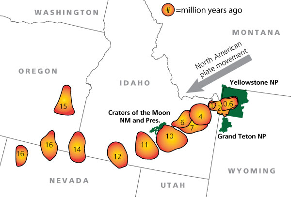
Also, seems the evidence (along with Albert’s comment supporting the mantle plume hypothesis) seems to support the plume hypothesis:
https://www.nature.com/articles/s41561-018-0075-y
https://agupubs.onlinelibrary.wiley.com/doi/full/10.1029/2019GC008490
It is good that we have these debates so that we can learn something new, but only if we stay nice. You might learn something, but do you have evidence against it so that we all could learn? If so, could you link them by copying the link and putting it into the reply? (Don’t do more than 3 per comment, though.)
Did 15 go for a wander?
Looks to be the Lake Owyhee caldera, but looks to be best described as a volcanic field while the Columbia River Basalts are taking shape. Maybe an isolated body of magma from the theorized plume:
https://www.researchgate.net/publication/258763688_Generation_of_Low_d18O_Silicic_Magmas_Bruneau-Jarbidge_Volcanic_Center_Yellowstone_Hotspot_Evidence_From_Zircons_Including_Oxygen_Isotopes_U-Th-Pb_Dating_and_Melt_Inclusions
https://www.researchgate.net/publication/284798233_Geology_of_the_Mid-Miocene_Rooster_Comb_Caldera_and_Lake_Owyhee_Volcanic_Field_eastern_Oregon_Silicic_volcanism_associated_with_Grande_Ronde_flood_basalt
https://www.volcanocafe.org/iceland-in-washington-a-musing-on-the-yellowstone-hot-spot/
Also, read this article from here. It is quite interesting that someone hypothesizes that this hotspot was here before the Columbia Flood basalts.
How’s about this for an explanation: there are not one but two plumes that happen to be roughly aligned with the overlying plate motion. The “leading” plume (the one a given spot on the plate overrides first) has carved a swath of destruction, leveling whole mountain ranges and generating a string of large calderas, and is currently parked directly beneath Yellowstone. The “trailing” plume encounters rock already fractured and thinned out by this activity (and also doesn’t have to cut the Farallon in two a bit farther down below, instead going through the gap already cut by the “leading” plume) and its basalt has a much easier time reaching the surface without getting stuck for a while and fractionating first. It is currently beneath Craters of the Moon. Before the leading one started carving its way through the Rockies, when both were under thinner crust, they jointly caused the Columbia River Flood Basalts.
“Leading” plume is deep-seated (look at those 3He numbers!) but the “trailing” one need not be. (How much 3He at Craters of the Moon?)
As to your question (deleted): no.
I tend to view radial dikes as a sure sign of a mantle plume, it’s just odd that the connection between CRB and the snake river caldera trail isn’t clearly linked, and that there is age-progressive volcanism westward from Steens as well as eastward.
I would like to see those maps but with microplate/cratons and/or deep tomographic imaging overlain, to see if other mechanisms are at work.
From this article (found free to download one)
https://www.researchgate.net/publication/215608644_Geodynamics_of_the_Yellowstone_hotspot_and_mantle_plume_Seismic_and_GPS_imaging_kinematics_and_mantle_flow
But it came from 2009.
As for the 3He levels, I presume they found it in the hot springs, but I found this chart on a paper in Academia (if anyone wants to log in to get a free download):

https://www.academia.edu/125544428/Helium_isotopes_in_geothermal_and_volcanic_gases_of_the_western_United_States_I_Regional_variability_and_magmatic_origin?auto=download
Corr. Plain
Great snowstorm for Houston and some of the Gulf Coast is under blizzard warning!
I moved from Omaha to Houston to avoid this…stuff. Got a little more than an inch. Thunderstorms this weekend, LOL.
Between the past year’s hurricane, derecho, and tornadoes, a bit of snow is a good reprieve.
Prepping for Reykjanes #dontcountthemanymore I can’t find a livestream with a good quake monitor anymore. Isn’t anyone still streaming the Skjalfti website?
Would appreciate any pointers! Any streaming site is fine, as long as it runs uninterrupted on iPad (no ads). The Skjalfti site itself won’t work since it stops updating after a couple minutes.
I found this one but IMO they cycle through too many different views, this is both annoying and confusing.
The south vent seems to be dark, it might be dead, will have to see.
The north vent though, this is the brightest I have ever seen it. HVO hasnt put out any pictures for a few days but I imagine there is a very active spattering lava pond visible in the vent from above.
Last episode ended on the 18th. Im putting episode 5 beginning on the 25th local time. And this time the fountains go taller than the rim 🙂
Albert, then I have to mention another possibility.
As I do not adhere to the ones who foster a plume there (simplifying things as plume theories always simplify more complex stories) I have to find points against myself.
There is another flood basalt up there, the Chilcotin group in British Columbia which erupted between ~ 6 to 2 Ma. ~2 Ma happens to be the time of the big eruption at Island Park Caldera.
The American Plate couldn’t have wandered in two directions, west and south at the same time.
There is a possibility though that, due to clockwise rotation the plume was under an area between British Columbia and Wyoming/Idaho at the time. Somewhere between Bozeman, Montana and Spokane, Wash.
And indeed, there is another lava field called Timber Hill in south-west Montana. The USGS describes a Hawaiian style lava flow there.
So, the possibility of a huge mantle plume with several heads could be an explanation to me. The alternative is the Farallon Plate and its spreading ridge. It needs to be remembered that it was a different landscape btw, flatter.
Altogether it needs to be noted, imho, that the United States geology is a much more complex story than say Iceland for a very simple reason: The abundance of material due to a time frame of over 2000 million (2 billion) years. Iceland and also Hawai’i are babies concerning age.
Likely because the Chilcotin Basalt Group are different from Yellowstone and different from the Columbia River Basalts.

From https://www.researchgate.net/publication/266261160_The_Chilcotin_basalts_British_Columbia_Canada_Geochemistry_petrogenesis_and_tectonic_significance
As noted, the isotopes are different (CRB meaning Columbia River Basalts) and are actually smaller than that of a typical flood basalt (i.e. 2,500 to 25,000 km³ in volume).
Seems the likely cause was some kind of athenospheric upwelling.
https://www.researchgate.net/publication/266261160_The_Chilcotin_basalts_British_Columbia_Canada_Geochemistry_petrogenesis_and_tectonic_significance
However, it is oddly close to the Cordelleran Volcanic Province.

From https://www.researchgate.net/publication/233779896_The_northern_Cordilleran_volcanic_province_A_northern_Basin_and_Range
Perhaps maybe the Chilcotin Basalt Group might as well still be active to this day, in the form of the Wells Grey-Clearwater volcanic field, last erupted around 1550 CE.

https://www.researchgate.net/publication/237172640_Late_Cenozoic_volcanic_rocks_of_the_Clearwater_-_Wells_Gray_area_British_Columbia
https://www.researchgate.net/publication/372714238_Pleistocene_to_Holocene_volcanism_in_the_Canadian_Cordillera
(Noted as WG-C)
Perhaps, what caused the Chilcotin Basalts to form is also keeping this “active” field to keep on going.
possibly leaking over the northern edge of Fallaron plate ?? WAG
https://www.researchgate.net/publication/215608639_Two-stage_subduction_history_under_North_America_inferred_from_finite-frequency_tomography

That is a possibility. Some parts of this slab are underneath this area. If we had this assumption, then that’ll mean it caused the Chilcotin Basalt Group. Something that was supposedly similar to the one that supposedly formed Paektu in North Korea (but I did remember Albert shot the idea down).
But, there is a snag. According to the one paper I linked, the Chilcotin Group did not have any sign of geochemical fingerprints that would tie it to subduction slab melting, which would have carved out of the edge. I haven’t really found any in-depth chemical investigations on the Wells Grey-Clearwater (maybe other than those with paywalls), but I would presumed something similar.
Then again, it is also possible since this is an apparent gap that never takes any of the slap material upwards. Still, this would make them seprate from the Columbia River Basalts as the Chilcotin Group lasted for 20-25 million years and also a different chemical fingerprint…
There’s now a fire burning between Fentale and Dofan, right on top of the dyke. The area of burned vegetation and the lack of a lava field says that this is a fire and not an eruption. Fentale caldera keeps filling up with the white stuff (is it fog generated from the fumaroles? is it milky white water?). Now there also seems to be visible fumaroles along the edges of the old lava inside the caldera and up towards the caldera rim.
https://apps.sentinel-hub.com/eo-browser/?zoom=12&lat=9.11159&lng=39.97547&themeId=DEFAULT-THEME&visualizationUrl=U2FsdGVkX18zfieYLELp2QE6f6BGEHWLeNcRUiOVbzzzhtb81Yg3EnuUCOaEivILlCTe0T8TbvEUnydA0nE18LLOuFaNLzcu2vGnLVSgyOIDOqfU27t2DaY7Df7IMCIi&datasetId=S2L2A&fromTime=2025-01-22T00%3A00%3A00.000Z&toTime=2025-01-22T23%3A59%3A59.999Z&layerId=2_TONEMAPPED_NATURAL_COLOR&demSource3D=%22MAPZEN%22
There was also a recent earthquake in the dyke area, maybe that triggered the recent fire or more activity in the area:
https://earthquake.usgs.gov/earthquakes/eventpage/us6000pli7/executive
This paper about the September-October intrusion in the Fentale area was published today: https://essopenarchive.org/users/847293/articles/1235148-the-2024-fentale-diking-episode-in-a-slow-extending-continental-rift
It is not milky water. The PLANET images (3-meter resolution) clearly show fluffy cloud structure around the edges.
I also realized that there are spectral filters that do an excellent job at detecting bodies of water, and they don’t show any water in the caldera. They do detect moisture, but below the threshold values to classify it as water.
The local climate is simply too barren for being a lake, but there coud be a seasonal one, it woud not suprise me if rainfall at Fentale is same as Scandinavia, its just that evaporation is way higher in the deep tropics, while here in subarctic, water stays at the surface being cooler and less evaporation… well Im so lazy and tired that I haves to check the data if my staement is true at all…. BTW Kilauea will be fun to watch the commig week with the open vent and growing cone
The rain is mainly in our summer. January is peak of the dry season in the region.
Maybe the volcano begins to release some Fumaroles like Vulcano or Campi Flegrei, that supply steam for higher humidity than the local climate would allow.
It’s possible that volcanic gasses and steam find paths to the surface, where magma doesn’t move to.
Zach, I appreciate your comments, however cannot read all of them. Will do that as soon as I have bought a new PC.
Did you see my reply up above? Set the phone browser to desktop mode and you will be able to read it.
Home Reef in Tonga has been erupting off and on, and the NASA Firms satellite picked up more activity. I checked the Copernicus browser, here’s what Home Reef looked like yesterday, Jan 21, 2025. https://ibb.co/1zNMRq1
Kilauea episode 5 apparently is beginning now, a little earlier than I expected. Lava is overflowing the north vent but not fountaining just yet. Maybe its just a warmup but if its like last time it will go for it within an hour.
🙂
I want to see a thousand-footer! 🙂
So do I, it looks like the south vent is dead, or if it isnt now then it will be after this episode I think. With only 1 vent the pressure should be higher and this taller fountains.
At the moment it looks like very high effusion rate of more degassed lava. Not a dome fountain but pretty low. Its getting taller though.
Here is one
A yellow millipede
Groaning. Well played.
Something I am wondering about this though, will the vent eventually do the same explosive jetting fountains Pu’u O’o did in its later fountain episodes?
These jets were extremely high, probably the tallest lava fountains of any sort from Hawaii, although its not clear if the height is absolute or from the crater rim.
“During the last 2 hours of activity there were three high fountain jets, ~50 minutes apart, that lasted several seconds . . . . Theodolite measurements of these jets, obtained for the first time, gave maximum heights of 550 m. Intermittent fountaining occurred the last 20 minutes of the episode, ending at 1635.”
If thats from the vent elevation at that time, its more like 720 meters tall. Or about 1500 meters above sea level. Based on this picture im actually inclined to go with this option.
https://encrypted-tbn0.gstatic.com/images?q=tbn:ANd9GcQmxzC-944maeeNYyxQDWHX8yIWRTiJHpYKaWPtNZ28LU-G-p0UEuvvMEsc&s=10
Pu’u O’o failed in the next episode, the pressure was too high. Same thing happened at Kilauea Iki, its final fountains were huge, 500 meters sustained, but didnt elevate the vent so relieved no pressure, magma had to go elsewhere. And 1960 had 500 meter fountains too, and 300 meter sustained even after vent failure, crazy. 2018 wasnt as unprecedented as it looked, really.
So maybe getting fountains of that sort of scale is a warning of the magma system about to fail. Pu’u O’o failing was mostly harmless, but another lower ERZ eruption isnt. This might be in 3 months or 5 years but still.
Wow the lava is fluid! looks just like the typical Halemaumau lava ”sheet pahoehoe” likey is fresh crystal free stuff from the depth.. it looks very fluid for soure perhaps due to the lower fountain , but the massive scale of the caldera floor makes it hard to judge scale and thicknesses of the lava flow.. I wants to go down there with helicopter and poke it
Yes its really different to the episode 4 lava. Its already covered most of that episodes lava in only 8 hours or so.
https://www.usgs.gov/volcanoes/kilauea/summit-webcams
If this goes for a few days like last time it might even cover the entire floor. I dont think it will last that long but who knows. I was hoping for some massive fountains though, which it seems isnt going to happen this time.
Well that didn’t last…
Yes, really fast, and hardly any deflation. The tilt will recover within 2 days if it goes the same as before. So either it resumes by then or doesnt and the next episode could be pretty big without the degassed plug on top. Its almost like this was accidental, not a ‘real’ episode.
It has already nearly recovered from the eruption deflation. At the same time it is interesting, that the beginning point of the episode was at lower inflation level than before. The summit has on average deflated since a peak in December:
Yes its deflated, at least that is what it looks like. As of yet there hasnt been any insar released since last year to see if there really is such deformation.
Still, assuming it is deflating, that is pretty normal I think. Last year the volcano had enough pressure to erupt on both rifts and the SWRZ eruption was at 1000 meters elevation. I think the summit still had to fill more but maybe being filled with liquid put too much pressure on the ring faults to let vents stay open at equilibrium.
Its also been a full month now, officially this is a long eruption, I dont think this is on the verge of ending particularly soon. Maybe if the vents build up to 1000 meters elevation, or start doing fountains taller than the caldera rim consistently for long duration, then it might mean high pressure and break out lower.
But its also entirely possible that the rifts just dont budge for a while and something as huge as 1986 Pu’u O’o forms, a 250 meter tall cone filling the rest of the 2018 caldera and burying the adjacent rim in a big cone, like Pu’u Puai but much larger, or even something that just breaks the records completely and we get another total summit overflow. Just a full focus on the summit for a while. Not my first pick but its completely possible and has happened before. These open geyser eruptions either last years or drain out catastrophically…
Years ago before any post-2018 eruptions, I said Kilaueas caldera would be one of the most dynamuc parts of the whole planet. Was a good prediction I think 🙂
It looks like a Strombolian lava lake eruption that does frequent on/off eruptions, but always with lava.
Probably this game is going to continue until another rift zone intrusion happens. The size of each episode is small enough to continue for a while until something else happens.
Yes, question is when that rift intrusion happens. Early on it was uncertain but now its been a month its pretty clear this vent is very robust. I dont see it changing for at least a year with what info we have now. And I put it about 50/50 this is still going on in 3 years with little change elsewhere.
If we look at the 2020-2024 eruptions, we see a tendency towards more episodic eruptions. 12/2020-3/2020 and 9/2021-12/2022 were predominantly steady and continuous eruptions. With the end of the 2nd eruption, Kilauea’s summit moved toward shorter, more discrete eruptions:
3rd eruption 1-3/2023
4th eruption twelve days 6/2023
5th eruption six days 9/2023
With each eruption the rate (volume/time) grew. The February 2024 intrusion in SWRZ confirmed this tendency … and resembles a bit the voluminous things that happened in early 19th century. Also the voluminous intrusions in MERZ in summer 2024 confirmed it. There may be more big things to come …
The current 6th eruption on the summit is purely episodic. It does big lava fountains that aren’t drowned by lava (unlike 2020-2022) but survive until the quick end of the episodes. Maybe the top height of the lava fountains shows, how high the current eruption will build the lava field/lake, until it’s over.
https://m.youtube.com/watch?v=w0KulR_3wQk&pp=ygUOa2lsYXVlYSB3ZWJjYW0%3D
Next eruption on Kilauea
To Steve, you wrote:
“The Skjalfti site itself won’t work since it stops updating after a couple minutes.”
https://vafri.is/quake/
I’m still using it. Hreinn Beck now has the note attached saying he’ll stop supporting it. I hope not.
I don’t know how promptly it’s updated. On Firefox, I “reload the tab”. Don’t know the equivalent on a phone.
I guess it’s just me, but beyond the basics, and news, I do find the IMO website …….. well, not very understandable. Many broken links. Funding gap probably.
I noticed yesterday’s (23 Jan.) small quake swarm at Brennisteinsfjöll, a volcano about which I knew nothing.
https://www.volcanodiscovery.com/brennisteinsfjoell.html
So I learned that it was a C19th sulphur mine, and tourists can now descend the inactive volcano cavern. I realised it was the descent featured on Prof. Brian Cox’s latest “Solar System” infotainment video.
https://youtu.be/NjSjqh_FVGY
What an experience that must be!
I hope Brennisteinsfjöll is spared from eruptive destruction, it appears not to be at risk, so far.
During the period of high seismicity leading up to the 2021 eruption at Fagradalsfjall, there was a lot of talk about the possibility of a large quake (M6-M6.5) in the Brennisteinsfjöll area. That possibility is still very real. With the current eruptive sequence at Reykjanes, it would not be very surprising if such a quake sets off a new sequence of events, possibly shifting the eruptive activity to the east. It could happen today, or it could happen in decades from now. There could also be a quake without an eruption. That’s usually the norm.
Has anyone seen the earthquake swarm near Hiuchi Volcano, NNW of Tokyo.
There’s been about 400+ earthquakes within a day with varying magnitudes.
This is the first I hear of it. Is it known whether it’s related to the volcano?
Not sure, most likely tectonic rather than magmatic I’m guessing, there was a much smaller swarm there the other day too.
The quakes themselves don’t seem to be in a line but rather a blob shape and the tend to be between 5 to 2.5km depth around 3 miles east of Mt Hiuchi.
It only caught my attention when I decided to look on Volcano Discovery which has a daily “quakes near volcanoes” report.
Bardarbunga has just changed to minor eruption from unrest on volcanodiscovery.
Bláfjallaskáli, part of Brennisteinsfjöll, recently has had more earthquake activity (swarm or not swarm?).
Bardarbunga’s unrest is over for now, and IMO has classified it down to green.
Although the dike hasn’t made it to the surface the damage is pretty severe:
Recent Earthquakes Displace 10,000 in Amhara’s North Shewa Zone – Affected Population Across Three Regions Nears 100,000 (24 Jan)
With literally weeks of having M4 and M5 tremors every four hours or so it’s not a surprise that the local houses have been shaken apart. And there appear to be cracks in the ground everywhere.
A few weeks after I arrived in Newcastle we had a M5.9, which killed 9 people and did a lot of damage. Fortunately not for me. By contrast to my one tremor these people have had something approaching a hundred serious tremors in the last month.
Storm “Eowyn” with hurricane force gusts up to 183km/h hits Ireland and UK: https://www.irishtimes.com/environment/2025/01/24/storm-eowyn-live-updates-status-red-warning-ireland-met-eireann-power-outages-transport/
We are in it at the moment, though some distance from the main part of the storm. Still quite windy.
Ireland broke its wind speed record earlier today
Yes, Ireland saved Wales, Northern England and Scotland from the worst storm, but it still looks heavy in the news.
To go on with the subject that also Zach from Canada is intersted in. We can travel from Chilcotin to the Columbia River Basalt and then to the Lunar Crater Volcanic Field in Nevada where we can see two volcanic remnants, one from the early Miocene, and one covering it, six million years old.
Going further south and looking at the mountains of the Mojave Desert from the east we see west-facing the Rhyolite welded volcanic tuffs crated also in the early Miocene.
We have two phases of volcanism in the area, one in the early Miocene, the other one from 6-2 Ma. When we align them all they run roughlly parallel to the Rocky mountains. So I get to the conclusion that all this was caused by the subducting Farallon Plate. In the north there would have been a heavy rock battle as the plate lost parts of it and subducted south of those parts with, of course, its spreading ridge to the Pacific Plate.
There might have been an additional mantle plume, but it is not needef to explain the setting. It would be much easier if subduction were still present or if the terrane that California seems to be had docked further south. If there were still subduction going on these volcanic mountains might be nearly as high as the Andes. But without it erosion is the main factor. In the subduction zone itsself of Farallon’s lost parts we can see the height in the Cascade Range.
It is like in Roman times on another timescale: plates fight. Where they are active there is volcanism, and Athens burns (Mount St.Helens). The Romans can stand for the Pacific Ocean. It dominates its borders.
It is a hilarious comparison, of course. However, I happened to look at a map of the Mediterranian political landscape at the time when Caesar was murdered (44BC), after he had completed and closed s.th. like a Ring of Fire around the Mediterranean Sea, from Gades/Cadiz in the West to Syria in the East, from Carthago in today’s Tunisia to Britain in the north-west and to the Danube in the north-east. The empire was painted red. Ring of Fire I thought and had to laugh.
The first one who didn’t burn down a valuable town was Caesar Augustus aka Octavian. I was asking myself whether the General who had the order to burn down Paris at the end of WW II and refused was thinking if him.
Take it lightly.
The old Pacific Ocean/Panthalassa though with its three mammoth plates often seems to be slightly underestimated.
Could you provide papers that show evidence this is all related? No offense, but I feel like you are eyeballing maps rather than scouring through the internet, finding papers and making conclusions (which is not good enough as chemical compositions are usually more reliable). Sure, tectonics could be related in some way but each volcano is different and even the cause is surprising. Take Deception Island for example. Looking at it, along with its caldera and a subduction zone to the northwest, you might come to the conclusion that these are related.
In actuality, it is formed by the spreading center. More info here: https://www.volcanocafe.org/deception-island-the-phoenix-rises/
Found a few more papers (free to download) and you could make your own conclusions.
https://pubs.geoscienceworld.org/gsa/geosphere/article/8/6/1274/132591/Basin-and-Range-volcanism-as-a-passive-response-to
https://www.researchgate.net/publication/223773895_High-K_alkali_basalts_of_the_Western_Snake_River_Plain_Idaho_Abrupt_transition_from_tholeiitic_to_mildly_alkaline_plume-derived_basalts
https://agupubs.onlinelibrary.wiley.com/doi/epdf/10.1002/ggge.20175
No papers. Am reading books and use my eyes. Will keep the titles of the books for myself for the time being, but one word: Books are about the whole thing, most papers about an aspect. So no refetence for the time being.
One cannot expect mor frome papers. Scientists who want to get on have to publish I think six papers a year in a leading journal, and competition is tight.
I wonder what book you are reading… papers are just as important, especially if they have raw data attached to them and also linking to dozens more papers. The papers I linked are all free to download, no paywall so that anyone could read them.
Could you link me to the book you are reading for all of this info? If you could, I could read it and make my own conclusions.
Yes, each Volcano is different in subduction zones, easily to be studied in South and Central America.
If volcanoes weren’t different from each other, even in the same area which is often a puzzle from geologic history, nobody would have found out by looking at ice cylindres from both poles which volcanoes erupted before historic eruptions.
“Let you in on the books” I am studying: No. sorry for that.
Well, the spreading ridge under Deception Island is due to the rollback of the subducted slab nearby. So if there weren’t a subduction zone there wouldn’t be a spreading ridge and no Deception Island. It’s a back-arc rift, not that different from the far more extensive Basin and Range of the US where Steens Mountain and Yellowstone are located.
My understanding is that the Basin and Range started a major episode of extension around 21-17 Ma, and mainly around 17 Ma, in what had previously been an Andean-like Altiplano, in this context of rapid extension, with the land sinking and turning into horsts and grabens across a vast area of western North America the Steens Mountain Basalt happened, and at present Yellowstone is still located within the Basin and Range province although they will soon move away from each other. I think the usual explanation is that a plume rose through a tear in the Farallon slab so there would be some relation:
“The timing of rapid extension coincided closely with a number of notable tectonic
events (Figs. 6 and 8C), including final removal of the Farallon slab ca. 20 Ma (Humphreys, 1995), development of a gap in the Farallon slab ca. 17 Ma and subsequent impingement of the Yellowstone hotspot (Liu and Stegman, 2012), and the progressive development of the San Andreas transform boundary with northward migration of the Mendocino triple junction over Neogene time (Atwater and Stock, 1998).”
https://www.researchgate.net/publication/339366516_Magmatism_migrating_topography_and_the_transition_from_Sevier_shortening_to_Basin_and_Range_extension_western_USA
That is true. Without that subduction zone, the spreading center would not exist and therefore no Deception Island. Point is that every volcano can be different. They may or may not have the same cause, but chemistry is important to see what said cause is, even if the cause is indrect (one leads to another sort of thing).
On that note, why would some sites (including Wikipedia and maybe even Google itself) try to connect the Chilcotin Basalt Group to the Columbia River Basalts in spite of very different chemical signatures or different time scales?
Not sure why some consider the Chilcotin Basalt and Columbia River Basalts related. The CRBG is a LIP, and as such had enormous intensity being erupted in a few short pulses. While the Chilcotin Basalts seem more of a normal volcanic province of a young orogen, like the Patagonian basalts, which are arguably still ongoing in the Anahim Volcanic Belt. But I don’t really know much about Chilcotin.
https://www.researchgate.net/publication/237407772_Discussion_of_The_origin_of_the_Columbia_River_flood_basalt_province_Plume_versus_nonplume_models
Maybe it is because of this paper in a discussion of plume vs. non-plume models for the Columbia River Basalts. First some reason, Chilcotin was named dropped in spite of it only mentioned twice. This map might’ve nailed this:

I wouldn’t take all that chemical signatures thing too seriously though. For example the Steens Basalt and Yellowstone basalts are worlds apart in terms of Nd143-Nd144 isotopic chemistry, near opposite ends of the planet’s spectrum. While the Grande Ronde basalts of the CRBG are in between the two. A lot of the CRBG is actually basaltic-andesite not basalt, with ratios of silica to magnesium oxide that are higher than is typical of strong oceanic hotspots like Hawaii or Galapagos, though sometimes shows in flood basalt and most often in subduction zones. And I think these same ratios are also higher than Yellowstone basalts though I haven’t checked. So magma chemistry is very complicated, if there’s anything that’s a plume signature is the helium isotopic composition, even that is an assumption though, and when you look closely complications surely show up.
I do agree with that notion. No volcano is ever the same, hell, the same volcano can produce two different magmas. However, I worry about chemical composition because it can tell the journey from the source to the surface and tell us what is going on. I don’t expect for the magma from the Yellowstone hotspot to ever be the same. If there is a trend of many samples of volcanic rock, it would mean something is going on.
In the case of the mass-volume Columbia River Basalts (at least as far as I heard), it contained some amounts of contamination in them, whereas the Chilcotin Basalts had the opposite, with little signs of contamination. I tried to find the magma-pulse chart for the Chilcotin but found none (at least so far), so I presumed it had a even, uniform eruptive rates, unlike the Columbia River Basalts which all happen in pulses within a few million years.
By the shape of the Columbia River Basalt dikes, there is indeed a tectonic influence on it, like you said. Even the Snake River Plains lavas have a general N-S trend of fissures, again influenced by the Basin and Range. It is only the caldera trends that show otherwise…
Yes, not every large extension of basalt should be considered a flood basalt. They are a different kind of beast that makes even things like Holuhraun or Leilani look like grains of salt. This quote from a blog puts the crazyness of the Columbia flood basalts into perspective:
“And… most of it erupted from fissures in eastern Oregon and Washington –the roots of which are now preserved as dikes. And… many of the lavas made it all the way to the Pacific Ocean. And… (here’s the outrageous part), on reaching the Pacific, many of the flows re-intruded into the existing sediments and sedimentary rocks along the coastline to form their own magma chambers, some of which were thousands of feet thick! AND… some basaltic magma from those chambers then re-intruded the country rock to form dikes –and some even re-erupted on the seafloor!”
https://geologictimepics.com/2015/01/31/columbia-river-basalt-group-outrageous/
It’s the same gargantuan structures that you see in the giant sills of the Karoo LIP, the giant dikes of the CAMP, the layered intrusion of the Bushveld LIP, or the massive lava flows in Mars.
That it is a hotspot progression similar to Hawaii and such, there is no doubt of that though, since there is gradual age progression that matches the direction of the North American plate, and I think the speed too. But that there’s some relation to the tectonic setting at the time may also be true.
Ill need to make a map to test if this is real or just a visual coincidence, but the B&R province at least in the north of its extent looks like a giant bow shock behind Yellowstone, as if the continent is being torn apart as it overrides the plume. Looks like at least up in the northern art the B&A is created by the plume rather than the other way. Also that its not really clear the Farallon is fully subducted, the actual divergent boundary isnt, but the slab might have torn off anyway. But Yellowstone and its trail of destruction is way too big to be just the same as the majority of other intraplate volcanism of inland west North America,
Also an interesting bit about Craters of the Moon is that its a’a looking flows are mostly trachyandesite, yet look no thicker than proximal basalt a’a flows and are of the type made by fissure eruptions at extremely high intensity, theres a 600 meter sustained fountain vent there too… The last series started with a Holuhraun sized lava flood, then 3-4 km3 of pahoehoe overflows, twice 70 km apart. Another episode in the early Holocene made several up to 30 km long a’a flows on dead flat terrain, which is getting to Laki scale. Also trachyandesite if I remember right. A lot of the flows are dated pretty poorly, giving ages of centuries apart to flows that clearly came from the same vents.
So basically, laki sized flood lava volcano erupting ultra fluid andesite, then a decades long shield eruption over top… 🙂
I’d be impressive to see Craters of the Moon erupt. It’s a very unusual volcano, if I try to think of other similar volcanoes I can’t come up with anything.
Regarding dating I remember that because it’s a very dry area there’s no or very little charcoal under the flows, so they had to resort to dating the soil which can really screws up the result. Even charcoal can be off by centuries, then soil can be off by thousands of years.
In Iceland there is Fremrinamar, north of Askja, a 50 km long fissure with some central volcano characteristics. Theres also Heiðarspoðar immediately next door, parent of Hverfjall and the lava surrounding Myvàtn. , although I think that is the north rift of Krafla it is sometimes separate.
But both of these are smaller than Craters of the Moon. Wapi lavafield is part of CoTM, and something like 90 km away along the rift axis yet stayed open to make a shield, must have been a huge intrusion. Volcanism here is of a very large scale, easily comparable to the biggest events in Iceland. Last episode was probably around 6-8 km3 over a few decades.
May I point out that we have an old post on this region? It may be worth reading
https://www.volcanocafe.org/the-snake-river/
You said in that piece that there is a 10! km thick piece of crust under the valley. I had to look that up for sure. And it is amazing: It is at least 10 km thick and they say sialic, so it might be 3-4 billion years old. That area is a history book, more difficult to decipher than the old Phoenicians.
John W. Shervais, John K. Vetter, Barry Benton Hanon: Layered Mafic Sill Complex beneath the Eastern Snake River Plain.
There will never be s.th. like a last word about the American Craton plus accreted terrain plus terranes, but 1000 years of work and puzzle.
Basically it looks like an old island arc, but nobody has found the ocean going with that. For sure everything there has been closer to the ocean once, esp. if this was placed on Laramidia, but the volcanism is much younger.
Great piece, btw
Oh, one thing: uplift. An estimated 2000 meters for the Colorafo Plateau at some period of time in the past 30 million years, Farallon subduction still being active plus extension in other areas.
2012 Yellowstone had a fictional eruption (VEI8?): https://www.youtube.com/watch?v=S1Kbym7WYzs
A bit too much phantastic action drama (explodes like a nuke, throughs too many volcanic bombs) like other volcano movies, but gives a sense of the awful beginning.
Avoid fictional eruptions in Yellowstone and the Phlegreian Fields plus fictional meteorite strikes, do yourself a favour. People for some reason like to be scared, that is why the Roman Plebs liked to see games with bloodshed. Try to be above that esp. if it comes from youtube.
Try to understand this, Vesuvius was so kind as to leave it for us unscathed:
About the “Momento Mori” mosaic from Pompey,
https://archeotrasimeno.wordpress.com
If you don’t find it, I will at the title
Spain’s mainland weak volcanism reminds to other European locations in France, Germany and Romania (Ciomadul). Last continental Spanish eruption was in Calatrava volcanic field in deep south between Almeria and Gibraltar. 3600 BC there was an explosion and Pyroclastic Flow.
Is the volcanism in Spain linked to the Europe-Africa collision or to the rotation of Iberia’s microcontinent? It is one like the Adria microplate that behaves a bit different than the big plates.
Extension!:
Alkali basalts and leucitides in an extensional intracontinental plate setting:…..
Cébria and López-Ruiz
The same is discussed for the Eifel VF
It is a bit of a mix in Spain. Most volcanism in western europe comes from the Alps (of course). Italy presses into the continent, and has caused (among other things) a line of extension running from Germany through the massif Central to northeast Spain. It connects several volcanic regions.
The Iberian microplate is rotating. This means that it can both have extension and subduction/collision in small areas close to each other. The Pyrenees are mountains built by subduction of the Iberian plate below the European plate.
Probably to both. Lots of faults in the Alboran Sea, earthquakes in Murcia, Granada, the sea itsself and Morocco of course.
Oh yes Héctor, there is considerable doubt. As long as there is science there has to be doubt:
One sc. article on this side begins i.e:
“The origin of the Yellowstone volcanic province remains debated”.
The role of a mantle plume in the formation of Yellowstone Volcanism,
Tiffany Leonard, Lijun Liu, Geophysical Research Letters, Jan 2016
Besides, Héctor, eruptions in the area Craters of the Moon started 15.000 years ago, occurred ~every 3.000 years and might happen again.
Craters of the Moon is about 250 miles from Yellowstone Nationalpark (as the crow flies).
Must be an enormous plume then, bigger than all of Iceland.
“Craters of the Moon, Idaho’s last (and next?) eruption”
USGS
Also interesting:
“Earth’s Core is leaking, scientists say”, CNN
Nature:
“Highest terestrial Helium-3/Helium 4 credibly from the core”,
Horton, Asimov, Boyes
About Baffin Island
That applies to most hotspots though, that they generally have ongoing volcanism along the trail of older volcanoes.
For example, in Hawaii, there is a vast active volcanic field around Kauai, Niihau, and Kaula islands, which is little known due to being almost entirely submarine. Practically the whole submarine flanks of Niihau and Kaula over a circle of 100 km wide is covered by massive, up to 500-meters tall each, shield volcanoes built on top of each other over the last 2 million years, erupting lavas that range from basalts to nephelinites. And number of young shields are also found on Kauai and its submarine flanks. This is twice as far from Kilauea as Craters of the Moon is from Yellowstone.
Similarly Samoa has very productive volcanic fields on Savai’i and Upolu islands 300-400 km behind the main Samoan volcano. The same might be said for Lanzarote in the Canary Islands or Mayotte in the Comores. It’s one of the anomalies in hotspot volcanism that are not well explained by traditional ideas.
That’s very interesting, Héctor. I’d definitely like to read more about it. It is different though.
The USGS speaks of “Rejuvenated Volcanism” after a gap of 2 million years with infrequent eruptios, the last 350 k years ago:
“Volcano Watch – a geologic tour of the Hawaiian Islands:
Kaua’i and Ni’ihau”, by HVO, USGS.
The eastern craters of the Snake River Plain are not rejuvenated after post-shield, but young and ongoing every ~3.000 years.
Kaua’i must be amazing, very wet though. It is thought to have featured in ~60 Hollywood films, among them “Raiders of the Lost Arc”.
It is inhabited by 200 indigenous Hawai’ians, first language besides English is Hawai’ian.
Text and pics
On
Claude Grandpey Volcans et Glaciers, Ni’ihau&Kaua’i, bilingual.
Amazing Canyons
Yes, it’s interesting. I wish the field was studied more exhaustively. We do not know the age of the last eruption in this volcanic field and we probably never will, since almost the entire field is underwater, only the few subaerial lavas, and a few submarine ones around Kaula, have been dated. But I agree that the Snake River Plain is more productive relative to Yellowstone than Hawaiian rejuvenated volcanism is relative to the Big Island.
Holcomb had a great map showing the submarine rejuvenated volcanism of Hawaii, although he missed some young lavas from the upper slopes of the Kaula-Kauai volcanoes. The North Hawaiian Arch volcanic field is also quite impressive, particularly in its enormous extent, but the Kaula-Kauai field has much thicker piles of lava:
https://pubs.usgs.gov/sim/2004/2824/SIM-2824_map.pdf
I think Lehua island north of Niihau is a Holocene volcanic vent. This crater is only 20 meters below sea level, in an area that is only drowned during interglacials, and yet the vent seems to have been a surtseyan eruption given the shape of the cone, and also that the lavas in the bathymetry downslope of Lehua are rough and pillow-like, probably emplaced underwater. The previous interglacial was over 100,000 years ago, and I think it’s impossible a tuff cone could have survived with so little erosion since then, and also because sea transgression at the beginning of the Holocene would have probably eroded the lavas downslope of Lehua, so must erupted within the last 12,000 years. The Koko rift vents in Oahu which also have some tuff cones that have been dated at 70,000-100,000 years old and are much more eroded than Lehua. This is Lehua:
The tuff cone that forms the island of Kaula seems also better-preserved than Koko Rift cones of Oahu. And there are likely similarly young eruptions in the sea north of Niihau where the greatest vent density is found.
The most famous impact crater (alternative source for Helium-4) on Baffin Island seems to be Haughton, alien size 1,2 miles, crater size 14 miles, 31-32million years ago.
One for Albert, which I have to post here because his excellent Messinian Salinity Crisis thread is now closed for comment.
Scientists Uncover Evidence of a Colossal Megaflood That Refilled the Mediterranean Sea (SciTechDaily, 24 Jan)
While the headline is a bit hyperbolic, since we’ve known about the megaflood for decades, there’re some nice scientific findings. A link to the paper is at the bottom, although I haven’t tried reading it.