
“The sun became dark and its darkness lasted for one and a half years… Each day it shone for about four hours and still this light was only a feeble shadow… the fruits did not ripen and the wine tasted like sour grapes.” Michael the Syrian, about a 6th century eruption
It smells. Sulfur is among the easiest detectable substances, and for good reason. It is a sign of decay, as in rotten eggs, and it is actively damaging to our bodies. Although not infallible, our noses give us a powerful stimulus to stay away from it. It also helps us to avoid active volcanoes. The sulfur smell is a good indicator of a potential eruption – and it can kill well before the lava does. But that gets ahead of the story.
The sulfur in our air comes from three main sources. The first is the living world: biogenic sulfur. Particular types of bacteria live on it, and many people guts have plenty of these (it actually depends on your diet). Life puts some 25 Tg sulfur per year into the atmosphere. (Tg stands for teragram, or 1012 gram, or about 1 billion kilogram, or 1 megaton.) (The word ‘tera’ may well come for Thera, the big eruption which devastated the pre-Greek Mediterranean. Volcanoes show up everywhere.) The next big source is humanity, in its hugely successful enterprise to change the world using coal and oil. We produce about 80 Tg per year by burning fossil fuels. Finally, volcanoes produce on average 9 Tg per year. About a third of the volcanic emissions come from non-erupting volcanoes, and the rest is associated with eruptions or with continuously active lava lakes. A big eruption can increase the number substantially in a particular year.
These numbers suggest that volcanoes are not a big problem. But it depends on where you look. Human (anthropogenic) emissions occur near the surface, where our chimneys and exhausts are. As a result our sulfur stays at low altitudes, and comes out of the atmosphere quite quickly; the majority does not travel far. Volcanoes deposit their gasses higher in the troposphere, by ejecting them at high temperatures and with a considerable push. Once they are in the upper atmosphere , they remain airborne for longer. At ground level, humanity is worse (you do not want to live close to a coal burning power station), but higher up, volcanoes have a greater effect because their sulfur hangs around and travels further.
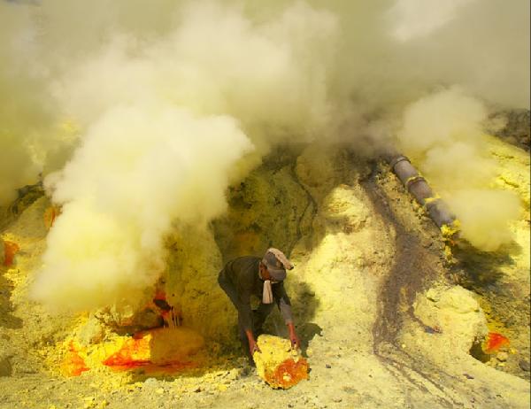
Volcanoes produce sulfur gas mainly as SO2, with minor amounts of H2S and H2SO4 and traces of carbonyl sulfide (COS) and its precursor carbon disulfide (CS2). In the air, H2S quickly oxidises to SO2. Underground, SO2 is not very volatile and it prefers to stay in the magma until the last possible moment. CO2 comes out of the magma while it still kilometers deep, and finds its way to the surface long before the magma does. Therefore CO2 is mainly produced by non-erupting volcanoes, and comes up all over the place, perhaps far from the eventual exit point of the magma. SO2 is a far more reluctant gas. When you find it in the air near a volcano, magma must be close to the surface and lava may follow soon. SO2 signals lava: it indicates an open vent. In Kilauea, the SO2 came from the caldera, and from the erupting fissures. The one exception is when fumaroles bring up sulfur through circulating water, exchanging gas with the magma. The rocks around these fumaroles can build up the characteristic yellow deposit.
Earthly sulfur
Sulfur is suprisingly common, but well hidden and not easy to see. There are many sulfur minerals in rocks (such as pyrite, or FeS), and the ocean has a considerable amount of sulfate. Epsom salts contain magnesium-sulfide. A common sulfate mineral is gypsum, used for alabaster, plaster, and chalk. Gypsum comes in part from sedimentation in volcanic hot springs, showing that volcanoes have an important role in the sulfur cycle. In he bible, sulfur was known as brimstone, found around the Dead Sea where it too comes up from the deep.
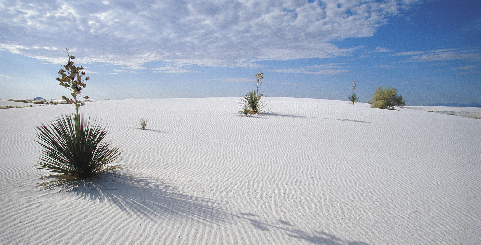
White sands, New Mexico, a gypsum desert. Source http://greatamericanadventure.net/white-sands/
But in spite of it being the 5th most common element on Earth, sulfur is almost absent in the atmosphere. SO4, the most common form, is highly solvable and loves to be in water. The atmosphere gets no look in. When by chance it does get into the air, it instantly triggers our sense of smell. Human noses are so sensitive to it that HVO has reported that SO2 from the Leilani fissures had become undetectable by their instruments whilst they were still able to smell it.
Biology has a complex relation to sulfur. It is both essential to life (three amino acids contain sulfur) and deadly to it (it is potent antibiotic and insecticide). The strength of human hair comes from an S-S bond. Biological sulfur is mainly in the form of organosulfur compounds. These are food to anaerobic bacteria, and the waste products produce the smells which we find so offensive, signaling decay. Various animals use this to their advantage: it is the source of the repulsive smell of the skunk, and the socially disabling smell of garlic.

Beauty in sulfate: a desert rose from Tunisia, grown from gypsum. Source: wikipedia
Magma invariably contains sulfur, as is already clear from the association between fumaroles and sulfur. But it is complex. Sulfur can dissolve into the magma either as S2- or as SO42-, depending on the oxygen content. The balance changes as the magma evolves. For instance, if magma degasses at high temperature, SO42- dissociates and SO2 forms, which stays in the melt. Mafic magmas (basaltic, from the mantle) can accommodate a higher level of dissolved sulfur than felsic magma (silicate, from the crust). Sulfur stays in the melt until it becomes saturated, and this happens later for basaltic magmas. But if basaltic magma incorporate some melted crust, it becomes saturated more quickly. The sulfur above the saturation limit is eventually expected to be outgassed into the atmosphere. In reality, things are more complicated. Sulfur concentrations in magma can be several thousand ppm. But what is emitted into the atmosphere can be ten to a hundred times more than what should be available in the magma. This sulfur problem suggests that a lot of sulfur congregates in a separate fluid inside the magma, rather than being incorporated in the melt. This fluid evaporates and provides the gas during the eruption.
Chemistry

The London killer fog of 1952
Volcanoes mainly emit SO2, and some H2S. These are unpleasant, poisonous gasses. But over time, if they remain in the atmosphere they become sulfates, SO4 which forms areosols, very small solid particles. The chemical reactions that do this are not fully understood. Sulfates were part of the famous London fog of 1952, and are probably the reason that that fog caused such a high fatality rate (anything a volcano can do, humanity can do better). In the fog, sulfate may have formed from a reaction of SO2 with NO2, in the presence of high humidity:
SO2(g) + 2NO2(g)+2H2O(aq)→2H+(aq) + SO42− (aq) +2 HONO(g).
The role of the water droplets is because SO2 does not easily dissolve in water but SO4 does.
The haze enveloping many Chinese cities also contains sulfate, and there it is believed a second reaction contributes, involving NH3:
2NH3(g) + SO2(g) + 2NO2(g) + 2H2O(aq)→2NH4+(aq)+SO42−(aq) + 2HONO(g).
The SO2 can come from burning fossil fuels, while NH3 can come from traffic.
Volcanoes work in a different way. The eruption columns contain water (it is often rather wet), and gasses such as HCl quickly dissolve into the water and drop back to earth. But SO2 does not dissolve: it survives the eruption column and can reach high altitudes. A major eruption can move material from the volcano to the stratosphere in 10 minutes. That leaves little time for decent chemistry. The conversion from SO2 to SO4 by oxidization happens in the stratosphere and is a slow process. It takes 30 days before half the SO2 is converted. There are several reaction pathways possible and it is not well known which is the dominant one. One option uses H2O2, which is generally in short supply; another uses OH, and a third one ozone (O3). The reactions require water, and the dryness of the stratosphere is probably the reason why the sulfates take some time to form.
Once present, SO4 can nucleate to form microscopic aerosols (around 0.01 micrometer), which coagulate to become larger particles.
Even in the absence of volcanoes, there are always some aerosols present in the stratosphere. They come from carbonyl-sulfide (COS), which is present in the oceans. Sprays in the oceans brings it up to the air, where it survives long enough to penetrate the stratosphere. Up there, photochemistry begins the conversion to sulfate. But major volcanoes increase this continuous aerosol layer by orders of magnitudes.
Over time, the aerosols float down and enter the upper troposphere. This process can take 1-2 years. In the upper troposphere, the aerosols act as condensation nuclei, and trigger the formation of extensive cirrus clouds. This is very similar to the aircraft contrails which dominate the skies over the UK (it is easy to forget how much more common blue skies were in the pre-flight days. Over the past decades, there have been two occasions where the air was closed to commercial flights. Both times, the blueness of the UK sky was notable.
Sulfuric volcanoes
Volcano mining
All volcanoes produce sulfur. Sulfur mines are in fact predominantly volcanic affairs; Europe used to get most of its sulfur from the slopes of Etna. The Bardarbunga eruption affected Iceland badly and raised SO2 levels even at times in Ireland. Effusive eruptions can be particularly bad because they don’t loft the gas as high: more stays at ground level.
The sulfur emissions from Kilauea are particularly well known. An overview of its emissions can be found at https://volcanoes.usgs.gov/observatories/hvo/hvo_volcano_watch.html?vwid=1379. To summarize, during the Pu’u’O’o eruption, the emissions averaged around 2000 tons of SO2 per day, although during the initial fountaining it as as high as 30,000 tons in a day. The outlook vent increased the emissions to 5000 tons, but at the expense of Pu’u’O’o where the emissions strongly declined. The lava clearly degassed at the summit before traveling down the rift. The Puna eruption was a sulfur disaster. Summit emissions went to 10,000 tons SO2 per day, but the Leilani rifts managed as much as 50,000 tons per day. After the eruption ended the emissions went down to less than 1000 tons per day, mostly from the summit. Before 1986, it was a few hundred tons. It shows how variable the emissions are, and how closely tied to the eruptions. The impact has been clear. Downwind from the lava channel, the vegetation has lost all it leaves. Upwind, the landscape has remained green.
Above we gave a number of 9 Tg of sulfur per year for all volcanoes. (The number for Hawaii given above is actually for SO2 rather than S: including the oxygen doubles the mass.) The average emissions of 2000 tons per day gives 0.36 Tg of sulfur per year. Kilauea in its normal state (Pu’u’O’o) is therefore not a major source of sulfur for the world. The Puna eruption is more significant: it produced roughly 1.5 Tg of sulfur, or one-sixth of the entire average volcanic produce per year. Still, it is very minor compared to the human production, bad for Hawaii but insignificant further afield.
What about the rest of the world? The image below shows the main volcanic sulphur emitters of the past 40 years. Kilauea is there, but is not the largest. The caption has a link to a movie showing when the eruptions happened.

From https://volcano.si.axismaps.io (the link shows a nice movie). Blue: earthquakes; orange: volcanoes; green: SO2. The symbols show events between 1960 and 2017; SO2 monitoring only started in 1978.
Going back further, the largest emitter over the past 300 years was Tambora, with an estimated 60 Tg of sulfur. Laki ranks a close second: it produced some 50 Tg. Other major events were Krakatoa (16 Tg), Pinatubo (8.5 Tg) and Santa Maria (6.5 Tg). (Remember that 1 Tg is equal to 1Mton: both units are used in the volcanic iterature.) These values are not particularly accurate, by the way. As a rough indication, a VEI5 explosions will produce 1 Tg of sulfur, and a VEI6 some 20Tg, but with large variations. It seems that the sulfur comes from a different part of the magma chamber, and therefore does not scale linearly with eruption magnitude.
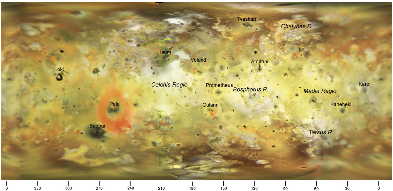
Map of Io, made by the USGS and the British Astronomical Society. The active volcano Pele has a lava lake.
Vog
One of the many benefits of the end of the Puna and Pu’u’O’o eruptions is that Hawaii no longer suffers from ‘vog’. The word stands for ‘volcanic smog’ and refers to the mist of sulfur particles that hangs around, reduces visibility and irritates the throat. When the outlook vent opened in 2008, the vog around the crater went through the roof (figuratively speaking) and health concerns led to the closure of the crater rim drive (the explosion hurling rocks on to the parking area was also a factor, of course). The trade winds tended to blow the vog southwest, keeping the main populated areas clear but Pahala was in the line of the sulfurous haze. When the trade winds died down, as happens regularly, the vog would spread elsewhere and affect Hilo. An interesting tidbit: the trade winds only extend up to 2 or 3 kilometers. If the haze gets higher, it spreads the other way, towards America. Kilauea was not active enough to reach this far. But Mauna Loa is much more energetic and is also much higher. Its eruptions inject directly into the higher air flows.

The expression ‘vog’ first appeared in the mid 20th century. The effect has of course been known for far longer: it is not unique to Hawaii. In fact Hawaii gets off rather lightly. During the Bardarbunga eruptions, sulfur smells were noted in Ireland. And it can get much worse. Laki led to ‘vog’ across northwestern Europe. The word wasn’t known, of course: even ‘Smog’ (originally smoke fog, before it became a byword for L.A.’s chemical haze) was still in the future. Instead these events were called ‘dry fog’. They were not just minor health hazards. Laki’s sulfur-smelling dry fogs became killers. Tens of thousands of farm workers died in the UK and the Netherlands, from breathing the toxic particles. Laki was the Volkswagen diesel engine of its time, and a repeat of Laki would definitely break European air standard regulation.
“The summer of the year 1783 was an amazing and portentous one, and full of horrible phænomena; for besides the alarming meteors and tremendous thunder-storms that affrightened and distressed the different countries of this kingdom, the peculiar haze, or smokey fog, that prevailed for many weeks in this island, and in every part of Europe, and even beyond its limits, was a most extraordinary appearance, unlike anything known within the memory of man. By my journal, I find that I had noticed this strange occurrence from June 23 to July 20 inclusive, during which period the wind varied to every quarter without making any alteration in the air. The sun, at noon, looked as blank as a clouded moon …” (Gilbert White, 1788 “Letter LXV.“ The Natural History of Selborne )
This dry fog was at ground level and the sulfur directly affected people and plants alike. The aristæ of the barley, which was coming into ear, became brown and weathered at their extremi- ties, as did the leaves of the oats; the rye had the appearance of being mildewed; so that the farmers were alarmed for those crops . . . The Larch, Wey- mouth Pine, and hardy Scotch fir, had the tips of their leaves withered; . . . The leaves of some ashes very much sheltered in my garden suffered greatly . . . All these vegetables appeared exactly as if a fire had been lighted near them, that had shrivelled and discoloured their leaves (Cullum, 1786. Philosophical Transactions of the Royal Society Abridged volume 15, 604.)
Many people in the open air experienced an uncomfortable pressure, headaches and experienced a difficulty breathing exactly like that encountered when the air is full of burning sulphur, asthmatics suffered to an even greater degree. […] the fog caused a great extermination of insects, particularly amongst leaf aphids. (Brugmans 1787, A physical treatise on a sulphuric smog as observed on the 24th of July 1783 in the province of Groningen and neighbouring countries., Leyden).
Europe did not know what had hit it. People attributed it to a great meteor, or the earthquakes in Italy. It took three months before news from Iceland reached Europe and rumours began of an eruption of Hekla. The Laki fissure wasn’t discovered until ten years later, and the link between the dry fog of 1783 and Laki was only understood after Krakatoa, a century later.
Stratosphere
If the particles reach much higher, they can become stratospheric. A volcano manages to reach the stratosphere about once every other year. On average, a tenth of the volcanic sulfur emissions reach the stratosphere (1Tg per year), but it is concentrated in a few big explosive events which can increase the sulfur load of the statosphere to as high as 100 times the normal values. And if it is a large eruption, the sulfate aerosols can quickly spread around the Earth. This gives the milky, hazy skies known, for instance, from the Tambora eruption. Equatorial eruptions can spread the haze worldwide; eruptions at intermediate latitudes tend to stay within their hemisphere, and polar eruptions tend to stay above the polar front. Famous white skies occurred in 1257 AD, 538 AD, and 44 BC. But this only happens after massive explosive eruptions.
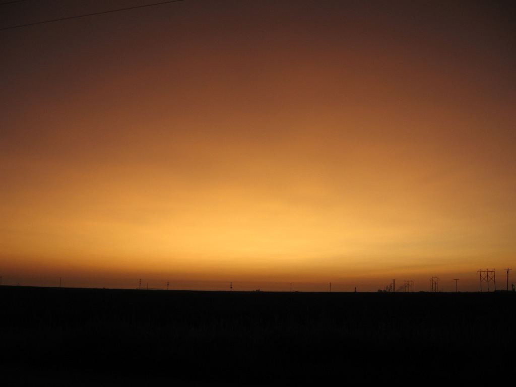
Sunrise on September 4th, 2008 over Hockley County, Texas, showing the colours of sulfur aerosols in the stratosphere from the Kasatochi volcanic eruption on August 7th (Aleutian Islands, Alaska). From http://www.mesonet.ttu.edu/cases/Ash_090408/Kasatochi.html
Stratospheric sulfur comes almost exclusively from subduction zone volcanoes. Spreading centres do not contribute, because their eruptions tend not to be explosive. The basaltic eruptions from oceanic hot spot volcanoes, such as Hawaii, also tend to be effusive rather than stratospheric. Their impacts remain more localized.
Flood basalt eruptions
Columbia flood basalt
Flood basalts are the largest eruptions on Earth. They are basaltic, and cover huge areas under kilometers thick layers. They are obviously not single eruptions, but a series of fissure lava flows, each perhaps 50 meters deep. Famous examples are the Siberian traps, the Deccan traps and the Columbia flood basalt. They often coincide with a mass extinction; in the case of the Siberian traps, one that came close to sterilizing the world. Can that be due to sulfur poisoning?
The flood basalts are similar to Icelandic fires, and form effusive eruptions from long fissures. They are on a different scale though, where the fissures may be 100’s of kilometers long and the lava flows can reach over 500 kilometer. The uniformity of the flows suggests that they barely cooled over that distance. There are two main models to explain this. In the first, the lava flows so fast that it has no time to cool. The second model suggests a much slower process where the lava flows underneath a solid crust, like the Kapoho flow field in its later stages. As an example, the Roza member of the Columbia basalt covers 40,000 km2 and has a volume of 1300 km3. The first model requires eruption rates of 1 km3 per day per kilometer of fissure, with a duration of weeks. In the second model, the eruption is much slower and lasted 10 years. That makes quite a difference, although it should be noted that in the real world, eruptions slow down as they age and the pressure behind them reduces.

Columbia flood basalt, the Roza flow. http://volcano.oregonstate.edu/book/export/html/486
The Roza basalt is estimated to have emitted 9,000 Mt of SO2, which may have been emitted over weeks or over 10 years. Compare this to the Puna eruption with its 3 Mt over 2 months: even if the Roza eruption lasted 10 years, that would still have outperformed Puna during its eruption by a factor of 60 – and would have continued 50 times longer. Tambora ejected some 60 Mt of SO2, and did so within 24 hours. Puna pales in comparison, at a paltry 0.05 Mt/day at its peak. On a daily basis, that is 25 times more than Roza (assuming the slow model) but over a year, Roza outperformed Tambora 15-fold – and it continued for another 10 years. Another comparison is Laki, which emitted some 100 Mt of SO2. If the majority of this was emitted within one year, the Roza eruption would have been nine times worse over that year, and it lasted ten times as long. Laki killed tens of thousands of people in northwestern Europe; Roza would have been much worse. We have seen nothing like it.
But how badly would this have affected the world? Effusive eruptions do not normally reach the stratosphere. The fissure eruptions would have send sulfur 5-10 kilometers up, but not much higher. The amount of cirrus would have exploded, probably over the entire northern hemisphere. This is not as effective in cooling the Earth as it would be in the stratosphere, because the intercepted heat still warms the air, but it would affect the air circulation and reduce thunder storm activity. Could the air itself become lethal? At concentrations of 10 ppm (10,000 times the level that our noses can detect), death can happen within hours. Lethal levels for prolonged exposure are not readily available, but can be assumed to be lower: 1 ppm (2mg/m3) is disabling even for short durations. Assuming that Roza erupted at a constant rate over 10 years, and that the SO2 lasted a month in the lower atmosphere, there would be 90 Tg in the air at any one time. If distributed in the lower kilometer, this would give a lethal level as far away as 5000 km. Ouch. A better calculation is obtained by assuming that the SO2 is spread out uniformly at 10 km/hr. Assuming a constant eruption, this gives a concentration of 80 ppm at 10 km, and a disabling radius of 800 km. (This also gives a limit for Leilani of 10 mile, which is reasonably close to reality. The numbers reduce if much of the SO2 is lofted into the upper atmosphere.)
Therefore, a flood basalt is deadly within 500 km, and ecologically devastating over as much as 1000’s of kilometers, but at this rate it doesn’t wipe out the world. Things are worse in the fast model where eruption rates are so much higher, but even there the effect is limited by how far the SO2 can travel before it drops out of the air. The winds on Earth are mainly east-west and so regions at the same latitude will be worst affected, and are areas far north or south much less so. The equator would act as an additional barrier, unless the eruption is in the tropical regions. A repeat of the Colombia flood basalt would wipe out much of North America, but leave most of the rest of the world alone.
It seems plausible that although the SO2 emissions from flood basalt eruptions were very damaging, they were insufficient to cause worldwide extinctions. Adding in CO2 may do just that, though, as it lasts much longer in the air and can cause severe overheating. The devastating extinction at the time of the Siberian traps were indeed caused by heat.
Final words
Sulfur is part of every volcanic eruption, and can turn an eruption into a killer. The gas spreads out further than the lava itself and affects many more people. Worldwide, our emissions far exceed those of volcanoes. Locally, volcanoes are important, as shown by the vogs of Hawaii, but worldwide, we now have other sulfur sources to worry about. Explosive eruptions can seed the stratosphere with sulfate aerosols and for a few years badly affect the climate. And looking back, the major flood basalt eruptions can have poisoned a significant part of the continent they occurred on. But the major extinction events attributed to flood basalts can not have been caused by just sulfur. CO2 is the more likely culprit. Still, volcanoes badly affect the air we breath. They smell.
Albert, August 2018


Very nice! Excellent article!
Side note. Gas Free Engineering is a specialty field in the USN. Before a sealed compartment can be entered, it has to be checked by a Gas Free Engineer to ensure that the air is safe. During training, one story that is used to emphasize this importance is the story of a peanut butter and jelly sandwich that was inadvertently left behind during a ships construction. Nothing other than the sandwich was in the compartment. When a worker opened the space and went inside, he died from the noxious gasses that had accumulated from the decomposition of the sandwich. True story or not, I don’t know. But the potential for it being real is there.
We had a question about how widespread the impact could be of the sulfur emissions of Kilauea. It is among the most productive volcanoes on Earth but how much does it contribute worldwide? This post grew out of an attempt to answer that question.
I’ve read that the mortality rate in Europe during the time frame of Laki went up by about 5%. Not just with the ill or infirmed, but predominantly in the field workers… ordinarily healthy people.
(Greater exposure → Heavy breathing from exertion made the damage from SO2 worse on their respiratory system)
Breathe
Key difference with Hawaii is the wind direction. Upper level winds typically move east over the islands while the trade winds move west at lower altitudes.
A very interesting article, Albert. Thank you!
Enjoyed the read. Great post. Thank you,
Regarding the thing about flood basalts and extinctions, I have often seen skepticism over that because of the apparent inconsistency. Some line up perfectly but then some are very big but have no major effects.
The reason for this is probably the eruption rate averaged over the length of activity. The Deccan traps was getting to 60 km3 of lava a year and that peak happens to occur over the KPg boundary, I think there is almost no doubt that this was a major part and the asteroid probably just sped up what was mostly an inevitability. Had the asteroid missed there could be some birds with teeth and mosasaurs/ plesiosaurs instead of whales (big marine animals actually seem to do well during these events surprisingly) but not a modern day Jurassic. It could have also been the unfortunate coincidence that the asteroid hit an evaporite deposit (lots of sulfur again, as well as chlorine) almost antipodal to the Deccan traps, there was no escape.
The Siberian traps were also hotspot derived and so at the peak there were probably similar numbers. This one causing the extinction is already in no doubt, the timing and scale is far too close to be a coincidence.
The reason the parana traps didn’t cause a mass extinction could be an indicator that this was not anywhere near as big as the others, maybe more of a tortoise than a hare.
Another thing, the opening stages of the flood basalts would have been stratospheric, skaftar fires was, and the km scale fountains and massive thermal effect of that much lava would be far bigger than any normal eruption. During most of kilaueas eruptions glowing but solid tephra was seen at over twice the height of the fountains, in 1959 apparently over 3 times (1.5 km high). In 2015 etna reached the edge of the stratosphere with a lava fountain.
Despite maybe only making up a few percent of the volume the initial stages would have still been a borderline VEI 7 during the roza eruption, so just on its own that gives an effect at least as bad as tambora before 95% of it even happens…
This explosive activity isn’t phreatic either, a study I read about kilaueas 1790 eruption showed that no amount of in situ groundwater would have any effect on an eruption big enough to classify as a VEI 4. The only way to get it was through a deep lake being present. Applying this elsewhere, there were no deep lakes over the skaftar fires area, so the water content of that area probably only contributed a negligible part of the tephra erupted. Big basalt eruptions are far more violent than simply being scaled up versions of small eruptions. Holuhraun and puna were at the very top of the ‘small’ section, grimsvotn 2011 was solidly in the ‘big’ section. Skaftar was probably the very top of the ‘big’, it seems to have been particularly aggressive at the start even compared to other eruptions like it.
Likely the flood basalts start of more or less plinian, but the eruption rate erodes the vents so that it can’t explode anymore and then lava erupts, still with high fountaining but not explosive. Eventually it is just a deep lake, as what happened at holuhraun and kilauea. Plinian eruptions from silicic volcanoes can make massive craters, so this is plausible.
I should clarify that marine animals seem to do better than terrestrial animals do when against terrestrial flood basalts. One of the only large things that survived the notorious P/T great dying event was Helicoprion, the famous ‘buzzsaw shark’ and biggest animal that ever existed up to that point in earths history. Same thing with ichthyosaurs surviving the T/J extinction, and big lamniform sharks surviving the K/Pg event. It seems like terrestrial and marine extinctions are somewhat independent at times, the chixulub meteor might have been worse in the ocean than on land.
SO2 does not dissolve well in water. It is notable that submarine flood basalts did not cause mass extinctions: only those on land did. Marine life is affected by acidification of water, as caused by SO4, but mainly hard-shelled animals. The killer in the sea is oxygen deprivation. That can be caused by run-off of organic debris (so more likely from the meteor strike than from the Deccan traps), loss of ocean circulation (warming up of the poles), or algae death (they can’t photosynthesize much above 30C). The Permian killer was heat, and therefore CO2 and methane. The KT event was mainly terrestrial but did not leave the sea untouched. All aquatic dinosaurs died out. Perhaps they required more oxygen than the proto-sharks.
I’m assuming by aquatic dinosaurs you mean plesiosaurs or mosasaurs. Both of those were closer to lizards than dinosaurs, actually mosasaurs share a common ancestor with varanids and probably snakes. Both would probably be very similar to cetaceans in their oxygen requirement. Mosasaurs were converging very closely to ichthyosaurs by the end of the Cretaceous (just look at Mosasaurus next to Temnodontosaurus, convergent evolution at its finest) so I think there would be a decent chance of them surviving in some way through the Deccan traps, same for plesiosaurs (which were not declining at the end despite most sources). This is actually a very interesting line of thought, that dinos might have been the least resilient of the iconic Mesozoic animals…
TD Six is still expected to wander off into the N Atlantic. But, they are putting an area next to Hispaniola at 40% chance of development.
Being this close to land and islands, it doesn’t have quite the potential as a Cape Verde system would to get anything really nasty going. Some sources are also claiming that the disturbance at the mouth of the Mississippi constitute a low like system. From the way individual pop-up storms are tracking though here it certainly seems like it.
CMC Model run for Florence.
http://moe.met.fsu.edu/cyclonephase/cmc/fcst/archive/18090112/20.html
Very interesting and nicely presented as always. Thanks Albert!
Somewhere out there, on the Internet, is a paper discussing the Laki flood basalts. It contains a figure much like the one provided here about the Roza flow, and the SO2 output. Within that paper is,a discussion and graphic that tries to quantify mass fraction of Sulfur based on the TiO2 to FeO ratios. If any of you run across it, I would appreciate a link to it or a notation of its title.
Thank You.
https://www.researchgate.net/publication/227193682_Sulfur_chlorine_and_fluorine_degassing_and_atmospheric_loading_by_the_1783-1784_AD_Laki_Skaftr_Fires_eruption_in_Iceland
The paper can be downloaded directly from the site, no need to sign up to anything (researchgate is much more friendly than the academica.eu site). It is Fig 14 in the paper
Don’t know how many people know, but if you have a paywalled paper, try copy-pasting the title in Google Scholar, sometimes it manages to find a site where you can access it.
Thank you very much. 😀
Lurk,
Here’s a paper with another version of that figure.
http://seismo.berkeley.edu/~manga/LIPS/thordarson03.pdf
Yup flood basalt event can get crazy huge.
The very largest continental flood basalts occurs when Supercontinents starts to rift apart.
Thats likley the largest Superplume events.
201 million years ago the initial rifting of Pangea formed the Central Atlantic Magmatic Province thats likley the largest land based lava flows in many 100 s of millions of years. Crazy event that was!. The flood basalts spanned over 5000 kilometers covering an arera almost the size of 11 million km2 in lava. It must been an absoutley crazy sight. The very huge release of co2 and Sulfur from these flood basalts caused the triassic jurassic exctintion event. This LIP event was even larger than Siberian Traps in volume.
These eruptions are on souch a wast scale its hard to Imagine.
These lava flows are today eroded down and broken up by the formation of the Atlantic.
Supercontinents acts like a blanket, trapping earths inner heat, the mantle cannot cool down and a superplume forms causing massive flood basalts and starts the slow process of forming a new ocean and later spreading ridge.
To get a mantle plume, you need a temperature gradient: hot at the bottom, cold at the top. Trap the heat at the top and the plume can’t rise or even form. It is true that a continent can insulate and the lithosphere underneath warm up. But it is either this or a plume, not both.
I think the action begins with subduction along the edges of the continent. This pulls the continent, and if you have subduction zones on both sides, it could pull the continent apart. The crust in the middle stretches and thins, and melt forms because of the lowering pressure.
I think it is unwise to try and allocate a single ’cause’ to many geologic processes. Its clear that under all the larger old continents lies an anomalous hot area, almost certainly due to a reduction in heatflow caused by the crust. Most of Africa and parts of eurasia have been uplifted by a lot (a couple of km?) and there must be associated stress on the crust as a result. However this seems to be fairly stable. Eventually, as Albert says, opposite sides of the continent are dragged apart by subduction elsewhere and this added stress is enough to start a graben somewhere inside the continental crust. Once the magma has a good route to the surface there is effectively a pressure equivalent to the uplift and given a big enough gap lava could be produced in epic proportions.
As we see in the record.
But the most powerful intraplate and largest hotspot event ( largest flood basalt ) is the Ontong Java Plateau 100 000000 km3 of lava erupted rapidly. That was sourely a huge plume head.
100 million holuhrauns erupted in the blink of an eye geologicaly. Woud be a fun sight haha
The Sulfur ”pollution” during the worst phases of Central Atlantic Magmatic Province and Siberian Traps and Ontong Java Plateau must have been really bad.
Anyone that can calculate the total sulfur volumes erupted by each of These LIP s in km3?
My Brain is horrible at maths
The OJP erupted some 20 km3 of magma per year. That is not dissimilar to Laki or Edgja. Obviously the rate may have been higher at times. But to give a rough number, it is about twice the total annual sulfur emission of our power stations. (The OJP occured under water which will have limited the impact.)
I would have expected the OJP to be bigger than that. Looks like my theory that it is the eruption rate rather than the volume which determines whether an extinction occurs. Hotspot flood basalts probably have a major advantage in that sector because most of the magma will surface, like in Hawaii now. Rift flood basalts will be handicapped by the rifting so a lot of the magma probably won’t erupt. Deccan was maybe not the biggest but the actual eruption rate was likely a lot higher than any of the otherwise much bigger flows. The CAMP basalts were probably quite fast too because an extinction happened and this was the first rift through Pangea. The parana traps 100 million years later was maybe big overall but seems to have been rather a lot slower and did not cause an extinction. A lot of these flood basalts might have been no more active than places like Iceland now, just bigger and the magma could collect to give bigger flows. There could well be places on earth today with potential for a true flood basalt but the signs aren’t recognised.
I remember reading something about the unusual lava nyiragongo erupts being a sign of possible flood basalt activity there in the near future (geological future). This area is not studied in detail because of frequent instability and challenging working conditions but nyamuragira and nyiragongo are both very formidable volcanoes and both seem to be young (maybe only a few tens of thousands of years. Already though nyamuragira dwarfs all the other virunga volcanoes, it appears to be almost a landlocked analogue of kilauea and probably its entire surface is less than a few thousand years old, still in its rapid growth stage. Volcanism in this area is relatively recent, but the rifting has been passive for a long time and created a lot of deep lakes very similar to the slightly younger Baikal rift, and the crust is domed up over the large plume below that area yet little volcanic activity has occurred except at the Virunga volcanoes. Maybe there is already a massive magma body under this area and it is on the verge of erupting, or maybe eruptions that big have happened before but have been contained within the rift and buried by younger lava from nyamuragira.
Don’t underestimate oceanic SO2. It makes literal battery acid.
How large would the cirrus shield from a traps eruption be? Larger than the area of dangerous surface SO2?
It occurs to me that the cirrus shield would cut down on the sunlight available for photosynthesis, which could prune a few branches off the upper parts of the food chain.
The Deccan Traps and Chicxulub impact were an evil, evil combination. The impact hit a shallow sea rich in carbonate minerals (the Gulf of Mexico) the vaporization of which liberated a shit-ton of CO2, which added to the copious CO2 from the Deccan Traps. And the dust veil thrown up by the impact would have combined with the cirrus shield from the Deccan Traps. So more warming and more dimming harming the food chain. The effects of the eruption and impact were additive. The Siberian Traps lacked a coincidentally timed large impact, but were simply bloody enormous, dwarfing the Deccan Traps, and some think they erupted through something that amplified the consequences. Carboniferous coal is one candidate amplifier, which would have increased both the sulfur and CO2 emissions when it burned. More recently I read somewhere a hypothesis that it erupted through a salt flat (or a salt marsh; the initial stages would have evaporated it into a salt flat rather quickly) and caused a toxic brew of chlorine and other unpleasant gases to be released into the atmosphere in large quantities. (Chlorine gas was used as a weapon during World War I. That’s how nasty it is.)
Hi ! IIRC, the ‘Worst of Times’ suggested a two stage die-off. First, a vast methane & CO2 bake-off as the plume approached the surface, then progressive sulphur emissions from the main eruptive phase. Regardless, Be NOT There !!
Curiously, LIP lethality seems to be inversely correlated to coastline lengths. Mega-continents suffer worse than our more-crinkly arrangement, suggesting coastal processes may mitigate the mayhem. However, correlation does not imply causation…
Supercontinents tend to be hothouses. They tend to lack mountain ranges (once eroded away) and the lack of rain on mountains means less CO2 is removed from the atmosphere. Now add lots more CO2 and you can get a runaway. That happened in the Permian extinction. Broekn continents as we have now tend to have cooler climates. Although we are working on that.
Side note. The Deccan traps have come up as a comparison topic in this discussion. The last article about Reunion, is the Hot Spot generally beleived to have been involved in the traps formation. It’s is also thought to be responsible for accelerating India along its path to push up the himalayas.
If Deccan was caused by reunion, then imagine what would happen if hawaii or iceland got overrun by a continent… Both are around 10 times as powerful as reunion, as can be seen when you compare an average eruption on kilauea to an average eruption on piton de la fournaise.
Some models show that in the next supercontinent cycle Australia might continue moving north through the middle of the Pacific Ocean after plowing through south east Asia, eventually ending up next to North America, and in doing so either it or Zealandia will overrun the Hawaii hotspot – 10x Deccan traps?… ._.
I don’t think Australia will actually move further north much because doing so would require a subduction zone to drag it north but who really knows, and if it does actually work out this way then…
“Sunda Trench”
It is already in the sunda trench though, I’m talking about it actually going through that entire area and then through the pacific to end up next to North America.
Personally, I think that when Australia proper gets to the trench, subduction will stop and possibly reverse (super-subduction, much like what formed the mountains in the region of Montenegro)
Australia will go north northeast and push PNG ahead of it
I may think it’s boring as @#$@, but Florida can always give you something nice to look at. This is a view the tops of the storms over Mobile and Mississippi area. Looking South-West from the parking lot of a local grocer.
And a view from Nexrad
There is nothing on “Differential Velocity” that is even close to tornadic, but its the sort of cloud structure that makes you sit up and take notice. The orientation and track of the storm line is like that of a feeder band, only without a tropical system to go with it. The putative Low over Texas/Louisiana is responsible.
Fun fact. If you put your back to the wind, the responsible Low will be to your left, if a High is driving it, it’s to your right. (Northern Hemisphere only)
Works same in the southern hemisphere only opposite.
Released from the spam bin – Admin
Guess I’ll get a break Wednesday to pick stuff up, and move things outa here.
I’m confused.
I’m not really seeing anything as a direct tropical threat to CONUS at this time.
Florence is generally headed to open water and will have to contend with a patch that is cooler than where it is at before it gets to warmer water… There is a chance that a blocking high will strengthen north of it, but that is not in the immediate idea of things to come. The “thing” on the Louisiana-Texas area doesn’t even have a stable circulation set up, and Tropical storms don’t generally form that close to land anyway. The thing near Haiti is just as disorganized, though could become something if it sets it’s mind on it… but the area is still not the best place to form with 10,000 ft mountains just south of it interfering with airflow.
As for the parking lot picture, the clouds are between me and the sun. This generally tends to make them look denser than they really are. It just struck me as an intense visual so I took a pic.
80% chance of the “thing” by the Islands becoming a storm in the Gulf, everybody is panicking.
One person says landfall around New Orleans Wednesday, I think this sounds very strange?
That would actually be a good thing. Fast movers don’t get much time to organize their wind fields. Based on NHCs graphic, it’s looking at about 13+kts forward motion. Not atypical, but it’s not gonna be beating around the bush about it. I hope their forecast holds. It will have about a day and a half of unfettered development and then it’s time to turn extra tropical be cause the show will be over. At that point, inland areas will have to deal with a low tracking up a front and the onshore flow will be quite moisture laden. Potentially fueling tornado outbreaks.
I guess I’m off to get a sack of potatoes.
The Key word here is “POTENTIAL.” That means it isn’t even a storm yet.
The HWRF model run seems to support the idea of it not having much time to get things together. Per this run, it might make cat 1 by landfall, but it’s gonna be close. (78 kt 10 meter winds)
Possible, I guess. Normal track would take it there… I still think they are getting their hopes up. It’s freaking September, that’s what is supposed to happen.
Meh…
Aa for its chances in the GOM. Really depends on how long it gets to loiter and get organized. The longer it can putz around, the more hazardous it can be.
Dunno. Might be a karma thing for S Florida. Lord knows they deserve it.
I feel better than I did this morning, expecting a lot of rain in AM, the 3 inches we got today was soaked up immediately but the mosquitoes are horrendous.
We are just catching the first of what will probably be a lot of thunderstorms.
http://www.lightningmaps.org/#y=30.5416;x=-87.2733;z=10;t=3;m=oss;r=0;s=0;o=0;b=5.80;n=0;d=2;dl=2;dc=0;ts=0;tr=1;
I did some research quickly into what I said on my last comment. Finally a long comment that’s ist Hawaii centered lol
Nyamuragira apparently has a volume of 500 km3 measured as its cone. Lake kivu has a depth of 400 meters, and about the same width as nyamuragira (~40 km). I remember reading once (I think it was on here but I don’t remember exactly) that there is known vigorous ash eruptions around the lake kivu area dating to about 11,000 years ago that probably represent nyamuragira breaching the surface of what was then a big lake, and if this is true then it has erupted 500 km3 in only about 10,000 years. This is lower than what I calculated for kilauea but it is still a very respectable 0.05 km3 per year, way higher than most other volcanoes and also a low estimate because that only concerns erupted magma. Nyiragongo is probably a bit older but the active cone seems to be young too, so all in all these volcanoes are about half what Hawaii erupts and probably about the same as Iceland, but much higher than etna and piton de la fournaise.
If lake albert and lake kivu were one lake before nyamuragira formed, then the volume of material needed to fill that part of the basin where nyamuragira is now is probably over 1000 km3, and although it wasn’t all volcanic and the age of the filling is unknown, at the rate things are going now it might have taken less than 30,000 years. Perhaps the fact nyamuragira is a basaltic shield volcano and nyiragongo is a former stratovolcano that has transitioned to erupting near ultramafic lava is a sign of recent significant change and probably a general increase in activity, the other volcanoes are conventional stratovolcanoes that have extensive evolved rocks and viscous lava.
It could be that there are very large deep magma reservoirs under nyamuragira that will one day feed much bigger flows in the rift. Some eruptions attributed to nyamuragira have happened very far from its summit to the north and south and these could have been fed from depth rather than lateral intrusions. 2011 in particular was very intense, 400 meter tall lava fountains feeding flows up to 13 km away and it occurred beyond the obvious edge of the shield.
Kilauea erupting 1 km3 of lava in the middle of a subdivision of 1500 people was pretty devastating, now imagine a n eruption on the scale of the skaftar fires that erupts ultra fluid lava and occurs within the boundary of a city of 5 million and counting… Then there is also the threat of an eruption in lake kivu triggering a limnic eruption and the methane getting set on fire by the lava……
Yeah maybe this should have been on NDVP, nyiragongo is already on the original list but I think this scenario is just a tiny bit worse…
Yeah it isn’t right around the corner but when you combine a very high magma supply with an active rift zone you basically get a tropical version of the SIVZ, which also just happens to be underneath a rapidly growing megacity that is also bordered on the other side by lake nyos x 10,000… Only one way this can end really.
The region is discussed in https://www.volcanocafe.org/lake-tanganyika-a-celebration-of-water-fish-and-distant-volcanoes/ The volcanoes have altered the drainage of the lakes considerably, and quite recently. It is a region in flux.
Well kilauea didnt erupt for a month, I think that is a record for my lifetime 😉
Now it is erupting again, very slowly…
https://www.facebook.com/extremeexposurefineartgallery/photos/pcb.1941127855956518/1941099292626041/?type=3&theater
Really good quality pictures.
I woud enjoy to see Deccan In action
The huge lava fountains and fast moving rivers
Souch a wonderful sight it must have been 😊
Flood basalts are Amazing
I can understand how impressive it must be. But the downsides outweigh the spectacle. Flood basalts are deadly at large distance. And even if not in themselves causing mass extinctions, in combination with other effects (such as a major meteor strike) they do. We are already pushing the climate into danger areas. This would be bad time for a flood basalt eruption.
Imagine a Tour de France in 1783. MOST of the contestants would die of respiratory failure. The highest performing athletes would all have to contend with SO2 destroying their lungs.
Laki essentially made the mortality rate in Europe rise by around 5%. And then the crops failed and all hell broke loose. It was a really bad time to be the guy in charge.
Deccan at the end was equivalent to 2 skaftar fires every year for 30,000 years, or a VEI 8 every 16 years, an eruption rate of 2000 m3.s as a base. Chances are that you wouldn’t have been able to go anywhere within 100 km of the active vents because they would be surrounded by lava. Deccan wasnt the biggest flood basalt, but it was probably the most intense one. It was basically olympus mons on earth…
It is kind of hard to imagine, especially as a lot of books/information are trying to bring a contradiction to this idea, but the popular perception of a flood basalt being like
non stop for a million years is actually not inaccurate for the Deccan traps at its peak (western ghats – 1.5 million km3 of lava in 30,000 years, K/Pg boundary included). In fact that eruption (one of the krafla fires) is way too small to be analogous…
looking into the future, remember the past
“Those who cannot remember the past are condemned to repeat it.”
–George Santayana
Thanks for the article , Albert that photo of the flood basalt of the Columbia River type is on the lower end of Grande Ronde that and the Imnaha drainage contain the oldest of the flood basalt. depending on the source >22million or so years old. I’ve camped there whitewater rafting. Make sure your tent has a snake barrier if you ever overnight there..
Back in my days as an DC-7 Airtanker Co-pilot flying in that country being a Co-Pilot running the systems, mean you didin’t have to look out. Of course seeing Big Horn sheep looking down at you from the corner of your eye wasn’t good either..
Not a well organized looking storm…
http://www.lightningmaps.org/#y=24.3421;x=-79.2059;z=7;t=3;m=oss;r=0;s=0;o=0;b=5.80;n=0;d=2;dl=2;dc=0;ts=0;tr=1;
Nice map, and Europe too.
Eh?
“He [Huracan] and Gúcumatz,the plumed serpent, handed the corn to Xmucane, who mixed corn with water to make dough. Out of this dough they made four men, Jaguar Quitze, Jaguar Night, Not Right Now and Dark Jaguar.”
Not Right Now? I wonder about the context of that. Is it someone who cannot or will not do it at the moment, or is it someone not right in the head? Given my pondering about Homo Stultus, think the second interpretation might be most accurate.
I had a look at the Wiki, and felt a sense of despair creep over me as I read: “The frying pans complained about their mouths being filled with ash and declared that they will be treated as them…”
Not, perhaps, the most intensely accurate Wiki entry going.
Looks like dodgy machine translations to me.
Which does support my Homo Stultus argument. Huracan is supposed to have assisted in getting rid of the “tree people” so that the “grain people” could be made.
The “tree people” not killed by the frying pans and turkeys became the monkeys.
Translation: he assisted the agricultural peoples in forcing out the hunter-gatherers as they conquered more land. 🙁
Probably quite accurste
Earth being the largest rocky planet, haves the most internal heating among the solid objects.
But there are rocky exoplanets thats much larger than Earth called ”Super Earths”
Super Earths like Gliese 667 C sourley are intensely geologicaly active because of its size.
Super Earths are larger it would generate more internal heat …a larger earth would be more geologically active. If earth was larger we would have more internal heating..More heat from compression as the planet formed, and more radioactive elements trapped deeper. and a larger planet retains its internal heat more.
A Larger earth would have stronger mantle convection and more and smaller plates
A larger Earth would likely be very geologically active with numerous ocean ridges and hyperactive spreading centers and subduction zones
the larger and more massive a rocky planet is the higher gear the geologically activity
-many plates, rifts, ranges and volcanoes; possibly so hot inside that its plates are more elastic than Earth’s.
Super Earth exoplanets maybe displays hyperactive tectonics and a faster mineral cycle
The continents are small and no or very small cratons because the high level of geologically activity
The result is an island world with no stable landmasses
That may be true but it probably varies a lot from planet to planet. The amount of radioactive material may be different for different planetary systems. The amount of water will certainly vary a lot (about half of the superearths appear to be ocean planets which more water than earth has). The mantle heat also depends on how well the crust insulates. Earth’s crust is relatively thin. Mars and Venus have thicker crusts which insulate better, so their mantles stay warm and both have or have had major volcanic activity. Age of the planet plays a role: Earth was much like you describe it 3 billion years ago.
To be honest I think a late collision resulting in a VERY large and VERY close moon are the reason for earth’s volcanic activity. All the planets with actual or suspected volcanoes are said to be heated by tidal action.
The other thing to remember is that the earth has had a double refractionation (due late collision) and also , despite losing much of the lighter fraction to the moon (and to space) has managed a thin atmosphere and a good mix of elements that are fairly ready obtainable on the surface.
Without the collision I suspect earth would be rather similar to venus, but a little cooler.
Umm, Venus has suspected volcanoes.
“Similar to Venus but cooler”
So basically the same as it is now but without the moon.
So size matters? 🙂
Yes
But a larger Super Earth will produce and retain more heat and be intensely geolgicaly active
Hyperactive Tectonics
Mars is a much smaller world than Earth
Its almost twice as small.
That meant that Mars cooled down twice as fast.
Today mars litosphere is extremely thick and inmobile tectonics are Impossible.
The immense volcanoes and oversized landscapes are signs of low gravity and thick litosphere.
Being smaller than Earth
Mars litosphere is likley many 100 s of km thick
Its very thick. It will be exciting when Mars InSight lands on mars to measure its heat flow.
Mars is between Earth and the Moon in size
Halfway between active Earth and dead Luna.
I expect to find a heat flow between Earth and Luna in strenght
Actually Mars would cool at a rate proportional to its mass compared to Earth, I think it is 1/10 of Earths mass roughly, because it is both visibly smaller but Earth is much denser too. Earth is probably unusually massive for a planet of its size, most earth-like planets are larger but less dense, the only planets with a higher density are those that border on being stars and cthonian planets that were formerly Neptune-like but lost their atmospheres, e.g. COROT-7 b. Earth has a very big iron core for what is otherwise a standard silicate planet, it is on the threshold between being called an iron planet. Many radioactive elements are attracted to iron so Earth probably has the highest endemic heat flow of any of the terrestrial objects in our solar system (io doesn’t count in that respect because it is driven by tidal forces)
I think Earth is also more massive than all the other solid objects in the solar system combined, excluding the Oort Cloud.
A super earth with these characteristics would most definitely be a very hostile place, the internal temperature of a super earth could probably approach 10,000 C or more, which would likely keep it all liquid and so such planets could have very powerful magnetic fields, amplified even more because bigger planets seem to spin faster. This would make any stellar effects basically negligible but also mean such a planet likely has a very thick atmosphere, even on the outer edge of a habitable zone the dense atmosphere and heating could turn it into a Venus-like hell planet.
Also, you do realise there is a reply option?
Super Earths will be tremedously active
Larger and cools more slowly than Earth do.
As I told before.. I imagines tectonic caos.
These large terestrial planets will be locked in archean like tectonic mayhem for billions of years.
Lots of subduction zones, rifts, mountain ranges, ridges. Volcanoes are very happy on a Super Earths.
No large continents or cratons there.
Just small twisted landmasses
I imagines a huge global ocean
With numerous small microcontinets and orogenic belts scattered everwhere.
Volcanic eruptions and thunderstorms
I imagines a dense humid atmosphere too and a distant yellowish looking dwarf sun
It would also probably have a lot of moons, or at least more than one, so there would be a few shadows cast on its surface. This might also cause these planets to slowly wobble a lot and end up with weird tilt angles like Uranus.
Also no tall mountains because of high gravity, volcanoes would all be wide but flat, basically all shield volcanoes, probably a lot of very wide but flat islands that are subject to intense activity like Hawaii.
Probably almost all mountains would be pretty flat too by our standards, likely not exceeding 4 km tall, but oceans would most likely be deeper and maybe subduction trenches would be relatively deeper too, so you might be able to get oceans that exceed the 20 km or even 30 km depth mark. I dont know how deep you have to make water before it can turn into ice 7 but at 20 km deep I think some pretty weird stuff would happen. Certainly I dont think any macroscopic life could live there without exploding if it went to higher water levels.
I hope one day there will be space crafts that can detect eruptions on super-earths, perhaps a surge in SO2 levels or means to detect sferics, indicating super-eruptions.
Super-earth sounds really fascinating places.
Anyway, looking forward to what JWST will find (although I don’t think it will detect lightning).
Held back for approval, by our spam deamon. It does this for all new commenters: future comments should appear without delay – admin
Everything else being the same, the cooling rate goes as 1/R (radius). Mars seems to have or have had one major plume. However, that does not mean a lack of volcanic activity: the surface shows a lot of volcanic features. Venus has the same radius as Earth and has very high activity but no plate tectonics. The two seem not closely related. But if plate tectonics exists, at high mantle temperatures you may get fast, small plates
With regards to LIP’s, Flood Basalts, etc, I would have to imagine it’s only a matter of time until we get another wave of flood basalts coming from the great African rift system. Given, most of us will be long dead by then, but given the fact that this is a continent actively breaking apart with an active superplume below, the next Flood Basalt eruption will probably come from somewhere in the African Rift system.
Did you see my comment on the situation around nyamuragira?
That area should be very capable of a flood basalt in the future, it is possible that nyamuragira is less than 30,000 years old in its entirety, with lake kivu being twice as big before then. Nyiragongo is maybe even more of a recent change, it is a stratovolcano like the other Virunga volcanoes and seems to be relatively normal in composition but in all its recent eruptions it has erupted very fluid lava, it’s lava would actually fall under the ultramafic range if it had more magnesium. This could have happened as recently as the last 1000 years (though that is a guess) This is very significant because it shows a rapidly evolving system, with a comparable rate of supply to Iceland and Hawaii. This is where I think the next true flood basalt scale flow (over 100 km3) will be from, probably in the next 50,000 years.
There is also the relatively smaller but way more frequent large eruptions that kilauea will be doing in the next 200,000 years as its shield stage reaches a maximum value. Mauna loa was similar to kilauea 200,000 years ago, but then it rapidly grew to over twice the volume in the geological blink of an eye, 50,000 km3 in 150,000 years or less, an eruption rate of 0.3 km3 per year, only ending its rapid growth around 20,000 years ago. Kilauea will do this too, it is probably on the verge of starting actually, and so it will basically double its already record breaking current activity and output…
Iceland also could do a really big flow in the next 200,000 years. Carl said as an answer to a question I asked last year that, under the right circumstances, it could be possible for a 250 km3 flow to happen, and that can’t be ruled out over such a long time.
So yeah there are a few potential flood basalts active right now, one of them is a disaster waiting to happen regardless of the long term effects…
Think skaftar fires under a city of 5+ million, simultaneous with a limnic eruption, and then that methane getting set on fire by the lava…
Tropical Iceland with ultra fluid lava + flammable version of lake nyos on steroids (and an overpopulated and rapidly growing megacity, set to reach 20+ million within a decade…) this sounds like a disaster movie plot…
For the sake of this article I should probably also mention nyamuragira is also one of the biggest emitters of SO2 out of any volcano anywhere, even when it isn’t erupting it is in the range of 5000 tons a day…
I got the idea of the Virunga area being a potential flood basalt from an article on volcanohotspot.wordpress.com, which I think is run by former users of volcanocafe. It is an interesting read.
The African rift would be a candidate. But the Columbia flood basalt came without a clear precursor, other than an approaching spreading centre. I think though that the most likely location is in Antarctica. But flood basalts occur tens of million years apart. The chance of one in the next million years is not high.
Hotspot is worth reading. They have well researched articles.
Big flood basalt provinces of 1 million km3+ in 1 million years or less happen tens of million years apart, but individual flood basalt-sized lava flows probably happen more often and in places that dont typically erupt that big and not repeatedly enough to make trap formations.
Also I wouldnt call the columbia river basalts a ‘big’ flood basalt, maybe just the most recent terrestrial one, there are probably quite a few oceanic provinces that have formed in the cenozoic that are bigger. One of them is Hawaii.
There are also some massive flows around Hawaii called the north arch volcanic field that are probably borderline flood basalts too but are not a thick plateau. The info says a volume of about 80 km3 total but given the flows are apparently confirmed to have had massive eruption rate, are as big as all the islands together in surface area as well as erupted in the deep sea I think there might be some underestimating on the volume. It is notable that they formed around 500,000-100,000 years ago, when Hawai’i was getting big and probably related to the same cause of why kilauea and mauna loa are much bigger than the other volcanoes before them.
Iceland is on the large end of LIPs, assuming it is a cylinder about 500 km wide and 20 km deep it would have a volume of about 4 million km3, though it formed over a different circumstance to most so it might be an outlier. However, there have been points where volcanism in Iceland was more intense than it is now so it has still been pretty excessive compared to world average.
I think you are redefining ‘flood basalt’ here. Iceland has the volume of one but it formed over at least 25 million years, so long that it overlapped with a real one. Hawaii similarly, it started when the dinosaurs were still around and is pretty active the Deccan would laugh at it. 80km3 is only a few times Eldgja. Normal magma chambers can easily reach that volume. Flood basalt eruptions are in a different category.
It is clear that the killer part of the flood basalts involves the atmosphere. Submarine flood basalts do not cause major extinctions.
Hawaii is Cretaceous in age but Maui Nui and Hawai’i are 2 million years old at most and contain more than half of the volume of the entire chain. Then it increases even more with mauna loa and kilauea being about 1/6 of the mass of the entire chain on their own in less than 1 million years.
The fact kilauea is the second biggest volcano in Hawaii by mass but it hasn’t gone through its maximum growth yet is saying enough. The Columbia river basalt formed over about 3 million years and has a volume of about 200,000 km3 originally, in that time the Hawaii hotspot has erupted around 600,000 km3 of material. I think that counts as a flood basalt, even if it hasn’t had 1000 km3 scale lava flows.
Here is the north arch lava flows.
I actually made an error before, the 80 km3 measurement is for a single lava flow on that province, the entire thing has probably tens to hundreds of flows over its area that are in that size, adding up to many thousands of km3 of lava.
From: https://www.mbari.org/flexural-arch/
Super Earths coud be even more life friendly than Earth is.
Being more geologicaly active that means a faster mineral cycle and more volcanic outgassing.
The atmosphere is always plenty of co2 that allows photosyntesis to thrive. A faster geological carbon cycle means snowball events and ice ages are less likley. Geological activity and co2 recycling lasts much longer on Super Earths.
Fast Plate Tectonics. The geological thermostat is stronger.
A denser air and higher air pressure ( 3 bars ) raises the oxygen pressure and allows animals to grow larger and supercharges their muscles.
Denser air also milds the global climate and makes equator – pole temperatures more equal.
Winters are less bad and poles are likley temperate like it was during earths greenhouse eras. Humid and temperate
Hyperactive Tectonics forms a hilly and varied landscape and a larger world means more isolated landmasses and islands that increase Galapagoian isolation. The continents will be numerous and varied and covered in forests.
Lots of enviroments.
A hotter interior and more molten core also creates a stronger magnetic shield that protects the atmosphere.
I meant that it would be very hostile to macroscopic earth life. Most things would probably overheat or get some sort of sickness from the air, 3 atmospheres is a lot, it is like being 30 meters underwater and you need training to avoid injury freediving to those depths.
A planet with a thick atmosphere will also have a huge greenhouse effect, Venus would still be a hell planet if it was put where the Earth is now, you would need to put that super earth much further from the star to keep it just right.
It would basically be a water world with a lot of Icelands and Hawaiis on it, like a bigger version of the hadean epoch, and there is no way you could call that habitable by our standards.
Also no oxygen, you need photosynthesis to generate that and a weaker star from distance as well as a lot of the light being blocked would result in less oxygen.
Let’s put some numbers in. A planet with twice the mass of the Earth but the same composition will have 20% larger radius. The surface gravity will be 1.2g, and the mantle will cool 20% slower. The atmosphere is unpredictable: on earth, that also has changed a lot over time. Because of higher gravity, the pressure below the crust is 20% higher. That means a lower melt fraction – there is less magma. On the other hand, if rifting would occur, the melting would go faster than on earth. You could expect that there are more flood basalt eruptions but less vigorous (or absent) spreading ridges. Because of the hotter mantle, the temperature gradient in the crust must be higher. The bottom of the oceanic crust stays hotter. Subduction will be more difficult, and oceanic plates may live for a billion rather than 200 million years [speculation alert]. The carbon cycle will be strongly dependent on the oceans, and thus the amount of water. That is unpredictable: the planet could be dry or be covered with 50-km deep oceans. The latter case feels more habitable, with as proviso that we don’t know whether life can form in oceans. There will be strong instabilities in the climate system, but that is true for Earth as well. The molten core will last longer (note that on Earth, the growth of the solid part of the core actually provides around 10% of the heat input to the bottom of the mantle). The planet would last longer as ‘livable’, if it has the correct star. On Earth the limit of life support will come from the Sun rather than the Earth’s interior. But if the sun were 5% smaller, it would be the other way around and life could last longer.
…sigh…
Now we have wall to wall “experts” hopping around on TV screaming for attention about Gordon… and that I should buy a matress. (Adverts)
I’ve got my sack of taters, I’m good.
Sky is gorgeous. Yeah, system is entering favorable conditions, but it is still a fast mover and won’t have a lot of time to strengthen.
USGS is reporting volcanic tremor at Veniaminof, Alaska
From last week’s USGS Weekly Volcanic Activity report:
Manam, Papua New Guinea
4.08°S, 145.037°E, Summit elev. 1807 m
RVO reported that an eruption at Manam began at around 0600 on 25 August after island residents reported increased activity beginning an hour before. According to the Darwin VAAC ash plumes visible in satellite data rose to 15.2 km (50,000 ft) a.s.l. and drifted WSW. The plume drifted W and NW, causing ash and scoria to fall in areas from Dangale in the NNE to Jogari in the SW part of the island. The most affected areas were Baliau and Kuluguma; residents reported fallen tree branches from the deposits, and conditions so dark that flashlights were needed to move around. Lava flows traveled down the NE valley and pyroclastic-flow deposits were evident in the NE valley all the way to the sea. The pyroclastic flows buried six houses in Boakure village though the occupants escaped to the nearby Abaria village. According to a news article about 2,000 people evacuated. The eruption ceased around 1030 with dense white emissions visible afterwards. During brief periods of good visibility after the eruption, and through 26 August, observers noted dense white vapor emissions and occasional light gray ash plumes.
50000 ft is close to stratospheric. Does anyone know what the sulfur volume was?
Directly? No. But an experimental estimate that I have been playing with (totally unverified and no idea of reliability) Puts Sunda trench systems at about 246.849415 ppm sulfur. (Based on interpretation of the geochemistry of Batur caldera from a paper by G. E. Wheller)
Batur is over on Bali, not the same location, but a similar setting.
Note: There are a LOT of problems with my method. I don’t even think this puts you in the ball-park… just within the same city that the game is played it. (I haven’t been able to reproduce my equations, and some arcane chemical processes deep in the crust can drastically affect the outcome.) {Oxygen fugacity etc…} This is the result of that TiO2 vs FeO thing I have been messing with. ← I can say that this was centered around geochemical work done on Laki tephra and magma, so it may not even fit Sunda Arc systems at all. Based on reputation, Sunda Arc systems tend to have quite a bit of sulfur. Even to the point of being suitable for marginal income harvesting.
In a nutshell, this is just a guess, and should be given no more relevance than that.
Also note that Wheller’s paper pointed out some pretty complex fault and crust interactions that may have affected the iron enrichment of the magmas and could throw my calculations way off, even if my method turns out to be correct. (which I put at a low likelihood anyway)
If you can find an estimate of the mass ejected, this might give a hint at how much of that was sulfur. You will need to multiply whatever you get by 32 to get an estimate of the mass of O2 that could include. (2 x 15.999 for the O2 part of it)
Total mass SO2 = Mass Sulfur + Mass Oxygen (from above)
… and the broadcastify link for Escambia County EMS and Fire… https://www.broadcastify.com/listen/ctid/332/web
I expect the bridges to be shut down when the winds get to 40mph, that is typical and would probably be late this evening if it happens. For anyone out on the beach, that blocks the typical way back to the mainland. Santa Rosa island is only accessible via bridge. (Bob Sykes Bridge on this end, Navarre bridge on the other end.)
A group of surf fishers spotted in the distance while I was at my daughters wedding.
Approximate location 30.336680N° – 87.108385W°
One of the houses out on Santa Rosa Island. Generally some of these are available for short term lease. The fishers in the previous pic are on the beach area roughly in front of this house on the other side of the dune.
Is that plastic on the bottom?
Might be. It’s common to enclose the lower non-livable area with lattice work or to just make a garage out of it. By law, all new construction must have the lowest floor open to withstand storm surge. This entire area was over run by the ocean during Ivan in 2004. The photo was taken this year when I was at my daughters wedding. They had rented a house out there for about a week. The place we were had a garage and restroom/changing area there next to a small pool. It worked great as a reception area.
Looking back through the Smithsonian’s eruptive history for Manam, a similar event occurred just over three years ago, Here are its statistics for emissions:
Start Date: 2015 Jul 31
Stop Date: 2015 Jul 31
Method: Satellite (Aura OMI)
SO2 Altitude Min: 19 km
SO2 Altitude Max: 19 km
Total SO2 Mass: 50 kt
I guess 50Ktons isn’t enough SO2 to have a significant effect on temperature despite its location near the equator and the column height. Is there an index for volcanic global weather effect? We sort of get VEI, though that needs to be qualified with some time scale. I mean a VEI4 within four days is different from a VEI4 over the course of four years, and would distinguish as disaster from a tourist attraction.
Each injection would follow a conversion and decay rate similar to this. Ultimately, it just leads to a denser Junge layer over time and adds to the background sulfate particulate density. After about 40 to 50 months, that sediments out to pre injection levels.
To impact global weather, you need an explosive eruption (otherwise too little reaches the stratosphere) and a minimum size of mid-6 VEI. A major climate disruption requires a VEI7. Krakatoa and Pinatubo were notable, but Tambora hurt and Rinjani was disastrous.
Laki clearly and dramatically impacted global weather (temperature) but never remotely released aerosols into the stratosphere. SO2 was, however, injected into the upper troposphere / lower stratosphere UT/LS over an extended period of months.
No Laki did not affect global weather. It affected northern hemisphere weather, and badly, but an eruption has to at or around the equator to affect things globally. Laki was far, far, far too far north to affect anything in the southern hemisphere.
The point was that Laki was able to create this massive impact in just a few months with nowhere near stratospheric emissions.
Laki affected climate around the North Atlantic only. There is little evidence for effects further afield. There was sulfur at ground level but not in the stratosphere, so the effects were local. There is some dispute how much of the weather (hot summer in north america, cold winter) was actually due to Laki. Probably some was. But it was not ‘massive’, apart from the SO2 haze which was a disaster in Iceland and Northwestern Europe.
See Section 5 from the following research.
https://www.research.ed.ac.uk/portal/files/11783768/Atmospheric.pdf
Extraordinary weather events occurring the same time as the Laki eruptions in 1783-1784 were documented as far away as India, Japan and the Eastern US.
That also finds that the effects are mainly around the Atlantic (eastern US and Europe) and does not show up as a worldwide statistical anomaly. It is very hard to proof that the events in Japan and India are related.
Total sulfate (SO4) aerosol deposition (kg/km2) in the year following the onset of the Laki eruption averaged from the three simulations presented in Oman et al. [2006a].
Oman, L., A. Robock, G. L. Stenchikov, T. Thordarson, D. Koch, D. T. Shindell, and C. Gao (2006a), Modeling the distribution of the volcanic aerosol cloud from the 1783–1784 Laki eruption, J. Geophys. Res., 111, D12209, doi:10.1029/2005JD006899.
Surface air temperature (SAT) anomaly (°C) for the winter of 1783–1784 (DJF) induced by the Laki eruption using the model simulations by Oman et al. [2006a, 2006b]. The SAT anomaly is calculated with respect to the 30‐year control run, and the hatching denotes the statistical significance at the 95% confidence level.
Oman, L., A. Robock, G. L. Stenchikov, T. Thordarson, D. Koch, D. T. Shindell, and C. Gao (2006a), Modeling the distribution of the volcanic aerosol cloud from the 1783–1784 Laki eruption, J. Geophys. Res., 111, D12209, doi:10.1029/2005JD006899.
Oman, L., A. Robock, G. L. Stenchikov, and T. Thordarson (2006b), High‐latitude eruptions cast shadow over the African monsoon and the flow of the Nile, Geophys. Res. Lett., 33, L18711, doi:10.1029/2006GL027665.
Again, it shows the main effects around the North Atlantic. 95% confidence is not normally sufficient to prove an effect, by the way. That means it would happen 5 times per century anyway. It also assumes a normal distribution and local weather outliers do not appear gaussian.
After Eldgja, there is a report of low water levels in the Nile. To strengthen the case for Laki, you would need to show that the same effects were seen after Eldgja. What did the Nile do in 1784?
There is this research that evaluates the Nile / Laki connection and also compares it to the Eldgja period.
http://climate.envsci.rutgers.edu/pdf/Laki_monsoonGRL10InPress.pdf
The researchers used records on the height of the Nile River that date back to 622 A.D. Record low Nile River water levels occurred in 1783-1784 following the Laki event. Similarly low levels were observed after the Mount Katmai, Alaska, eruption in 1912, when the Niger River was also at a record low.
The significance of the low-flow anomalies following Laki and Katmai are above the 97% confidence level using 80 years of data surrounding each event, meaning there is less than a 3% chance that each of these anomalies occurred by natural variability within the climate system. Also, the chance that both of these low-flow years following Laki and Katmai are due to natural variability is exceedingly small.
This pattern is definitely consistent with 939 A.D. when there was also low Nile River flow following the Eldgjá eruption in Iceland.
Skaftar fires was stratospheric at the start, it’s opening stages would have been like grimsvotn 2011 – a basaltic plinian eruption that on its own would have been been one of Icelands biggest eruptions.
It was only after this intense activity eroded the vents to a larger diameter where the magma wasn’t shattered that lava erupted, and even then it was still going 1-2 km into the air. It is hard to shatter a very fluid magma like that which erupted from the laki fissures, but give it an eruption rate of 5000-10,000 m3 a second and you can do it.
If you watch videos of really high lava fountains, they are not like the ‘small’ 80 meter fountains from kilauea in May, there is a tall eruption column above the fountain that looks very like a plinian eruption, and many smaller plinian eruptions viewed at night would have a lava fountain at the base, there is a particularly gold example from calbuco in 2015. Even the recent explosion from manam a few days ago had a jetting lava fountain.
Grading eruptions as hawaiian>strombolian>vulcanian>peleean>plinian is far oversimplifying the matter, and gives a very missleading impression of hawaiian eruptions as being the smallest sort of eruptions.
Maybe a new line has to be added directly between plinian and hawaiian that bridges that gap and bypasses the other kinds. I would call it an etnean eruption, because etna seems to do the majority of them. These are eruptions of fluid basalt that are too fast to be truly effusive but are not fragmenting ash at depth within the conduit. I also called them ultrastrombolian eruptions before, but etna is literally the ‘ultra’ stromboli so I think that fits better.
https://www.youtube.com/watch?v=oQPAawaY2D8&ab_channel=GeologyPage
This is what I mean. Imagine this but along a maybe 10 km fissure and you basically get the first stage of the skaftar fires eruptions.
All of the research I have ever read has concluded that the Laki eruptions (there were 10 separate significant episodes over a 5 month period) created gas column heights that reached to between 9km and 13km. Well above the tropopause and into the upper troposphere but nowhere near stratospheric.
That is probably the main eruption but what I am talking about is the first few days when the eruption was not effusive. Grimsvotn 2011 was basically a modern day version of that, erupting the same amount of magma as holuhraun but in 5 days instead of 6 months. The speed and size of the eruption alone suggest it was not just explosive because of water intereaction, but it was probably going to be that way anyway to some extent.
Trying to fit 10,000 m3/s of a very heavy 1200 C viscous liquid through a 10 meter wide hole made from what is basically compressed gravel for 3 days is going to be a rather violent event, think fire hose through a 1 mm wide hole… This stage probably only erupted about 10% of the magma and most of the damage would have been afterwards but the eruption was way more agressive and violent than it is usually portrayed.
This is where the VEI scale completely fails as a measurement. On most scales laki is a VEI 4 , and so was eyafjallajokull. So the news thinks they were comparable and that laki probably wasnt that bad, when in reality laki was about 150 times bigger than eyafjallajokull. Laki was a very large VEI 6 in terms of magma, and in energy output it was one of earths largest holocene eruptions full stop, bigger than any caldera event including borderline supervolcanoes like kikai.
Well, Gordon is almost here… but it looks like it got mugged on the trip across the GOM.
No kidding about moving fast 😀
… and the latest “wobble” seems to point to a near direct strike here. I’m glad it’s poorly organized.
Should have had a more descriptive name. How about James Dean?
“…too fast to live, too young to die…” (from an Eagles song)
Now, a pretty neat thing about Pensacola. Several years ago, we lost the training carrier Lexington. Recently, the USCG has been moving assets here since NAS is well equipped to provide husbanding services to military class surface vessels.
Just worried about your tree and electricity, Brett Adair heading your way and it is already pouring.
https://livestormchasing.com/map
Most of the TV Weather twits are conglomerating over in Gulf Port MS. Appears they missed again. Thing took a slice and is headed here. Fortunately, it never got the eye fully closed due to the sheer along it’s fast track along the GOM. It still has a chance to ramp up a bit, but it’s running out of time fast.
The ultra stupid? According to local news, they are showing only a single red flag at the beach. Technically that means that highly experienced beach users can still go out in it. (brain dead surfers). You get caught in a rip at this moment in time, you are flat out done.
http://www.lightningmaps.org/#y=29.4528;x=-86.9746;z=9;t=3;m=oss;r=0;s=0;o=0;b=5.80;n=0;d=2;dl=2;dc=0;ts=0;tr=1;
I’m just guessing here, but I think one of the reasons they don’t come here is that if they are down at the beach, and things go bad, they aren’t getting off the barrier island. At 40mph winds the bridges get secured to traffic.
About an hour ago they [finally] announced double red flags at the beach. (stay out of the water)
Very cool picture:
 ?ve=1&tl=1
The Villarrica Volcano is seen at night from Pucon, Chile, Sept. 2, 2018
OOPS via Fox news….
I spotted an article featuring recent research about the position of Mt St. Helen’s. Hope some of you find it interesting! https://www.sciencedaily.com/releases/2018/09/180904093838.htm .
Good paper, explains much about that system. down on south end of the Cascades there is Rustler peak -shield volcano west of the main cascade range.this is near Medford, Oregon it may have more to do with the Shasta/Medicine Lake system than the Cascades.
Mobile Alabama Nexrad if you wish to look at the internal structure of Gordon
http://weather.cod.edu/satrad/nexrad/index.php?type=MOB-N0Q-1-12
Hmm not much if any of an eye, looks wet though….
Yeah, the thing never got a closed eyewall. It’s gone through several replacement cycles but without getting it closed, it couldn’t establish a good flow structure. At least this time we don’t have Geraldo Rivera downtown dragging tree branches around trying to make a more exciting looking shot for his segment. Funny thing, if he had stuck around, later in that same storm an air conditioning unit was blown off the civic center and splatted a car in that parking lot.
… and Gordon might have a problem…
Earlier today, I was looking at the Nexrad showing the CDO and it was pushing 50 to 54kft cloud tops.
Right now, I don’t see anything over about 30kft. Seasonal pop-corn thunderstorms do that with ease. Might not be much energy left for it to feed on. As soon as that Northern ‘sort of’ an eye-wall goes feet dry, this thing is pretty much done. Yeah, it will drag a crap ton of moisture ashore, but it’s days as a spooky tropical storm are over.
Which reminds me. From time to time, you will hear some alarmist story about the “aging electrical infrastructure”… how come they never seem to take into account that much of the SE electrical infrastructure gets replaced and reworked on a fairly constant schedule? (Tropical storms) The same could be said of the Northeast with their regularly scheduled Ice storms.
Not very impressive. I see that the news lied again. There’s only one red flag flying. Even as sedate as this appears, only an idiot would be out in that.
http://pensacolasurf.com/webcams
Gordon still has another 6 hours or so over warm waters near 30C,

which in combination with an upper-level environment of diffluent

southeasterly upper-level flow and increased surface convergence due

to land interaction will provide a brief window of opportunity for

Gordon to reach hurricane strength before landfall
https://www.nhc.noaa.gov/text/refresh/MIATCDAT2+shtml/042051.shtml?
… so basically, Gordons only real chance to reach hurricane wind speeds is from smacking into land. Sort of an inertial effect as it’s constituent storms smash into each other.
And the wind profile for anyone who is interested.
Looks like a normal day at the beach in our part of the world, average swell is 4 and 8 feet though the wind is probably a bit more extreme than we are used to.
Seen more impressive Sou’Westers on the Oregon coast…
Reminds me of a story-Columbia Bar Pilots are now flown out to ships via Helicopter. at
the beginning the contracted with this firm from Louisiana. When they started the Pilots wouldn’t fly in winds higher than oh35ktG65kt So they contracted an outfit from Anchorage..
Ex Coast Guard pilots. No problem after that… This was bout 15 years ago..
Apparently Mobile Alabama gets this one. Again, I get to ride out the Eastern “eyewall.”… if you can call it that. Much less spooky than 2004. (115 mph) In my opinion, this thing is more of a nuisance storm than anything else.
To be brutally honest though, these sort of storms are the real killers. People get frantic about the storm and make massive preps… only to have something this peaceful roll ashore. Later, when threatened by a real monster, they think it’s just gonna be a repeat of what they have already experienced. That’s how the Richelieu Manor Apartments catastrophe happened.
Anecdotally, one version of the story states that the only survivor floated out of a 3rd window on a mattress that became lodged in a pine tree 12 miles inland. [take that for what it’s worth] However, the storm surge was recorded at being around 24 feet (7.3 m). (The ultra gentle gradient of our continental shelf facilitates the water piling up as the waves come in)
Not anecdotal… Huricane Katrina literally wiped Waveland MS off the map in 2005. If I remember correctly, something similar happened in 1969. Katrina was Cat 3, Camille was cat 5. However, Katrina had about the same mass as Camille and had just spun down from Cat 5 before landfall. Ivan, the one that got me in 2004 was a spinning down system as well and arrived at Cat 3. (Which is why I’m quite pleased that Gordon only managed to gimp it’s way across the gulf)
Oh look. 5 AM, another feeder band…
USCG will fly in almost anything.
I have been reading up on how solar cycles change the amount of water vapor in the atmosphere. At solar max, both higher UV radiation and flares have a tendency to bust up water molecules or plain sweep them out of the atmosphere. A really big CME can wring close to 10% of the water vapor from the sky. During solar minimum, all that shuts down and the water vapor just builds up and you huge deluge events wherever it gets concentrated. This effect may have contributed to the East Coast snowpocalypse in 2010. What’s interesting about this minimum is that it’s happening early and may already be ending. Last week, there was a minor outbreak of sunspots and one had reverse polarity. That would be consistent with the beginning of the next solar cycle, but it appeared in the equatorial region rather than the higher latitudes. Usually new sun spots for a new cycle begin at the higher latitudes and work their way down toward the solar equator. Now, it may just be that we never had good enough instrumentation to measure sunspot polarity with this accuracy, so the oddity with this reverse polarity sun spot may only be that we saw it and documented it, not that it occurred.
Getting this back to the topic at hand, with GeoLurker’s SO2 decay chart, how does the variation in available water vapor accelerate or slow the rate SO2 converts to sulfates and they precipitate out of the atmosphere?
Dunno, but I have pond on my front door. Per Nexrad, I’m in the 3.8 inch total range right now…. no end in sight. (Got one of the persistent feeder bands parked on me right now, and the storm center is 350+ road miles away over Jackson MS.)
More water should equal easier and faster sulfate conversation.
I’ve even seen one paper that looked at tropical volcanoes having a greater scavenge rate for SO2 from the higher humidity, lessening the amount that makes it to the stratosphere.
Can’t look for it right now, no power and the electric company keeps jerk in me around about when they can send a crew. They keep pushing the arrival time out several hours at a time. I’ve been “promised” 2AM, 12PM, and now 1700.
Last time it wound up being 5 weeks.
11,500 out. A little more than at 4am.
Well, I’ve got power to the pole, but have to get an electrician to replace my drop. Limb sliced it off relatively clean.
In theory, I should be sort of operable this evening.
Good question. FWIW, solar activity also directly impacts the height of the tropopause and by association the Junge Layer….however how much varies a great deal on latitude, and lag time. Since most of the SO2 we’re interested in is within the Junge (aerosol) layer, any appreciable changes in the tropopause should translate to different rates of SO2 decay. Also, it’s my understanding that high-energy particles and not UV that drives the bulk of the atmospheric response (Schuurmanns and Oort (1969). During solar max, CME’s and other sources increases the solar wind which in turn helps deflect cosmic rays away from Earth. During solar min, there is a dearth of solar radiation that “sweeps” away cosmic rays, hence we are now seeing an corresponding increase in these high-energy particles making it to Earth. An ongoing experiment conducted by a student group called Earth to Sky Calculus is confirming that along with the onset of solar minimum and a reduction in the solar magnetic field, cosmic rays at the Reneger-Pfotzer maximum (~ 67,000′ over California) are now 18% higher than in 2015. The effects of cosmic rays are very much under study ATTM, but there is evidence that cosmic rays can affect weather through cloud seeding, lightning trigger, and changes aerosol concentrations.
There have been several claims that cosmic rays can act as cloud seeds. The main problem with this is that the cosmic ray variation on earth is actually quite small, of order 10%. It is hard to see how a 10% variation in a minor contributor to clouds formation would have much of an effect. The discussion is on-going. A paper in 2012 (after the main claims appeared) by Laken states
Despite over 35 years of constant satellite-based measurements of cloud, reliable evidence of a long-hypothesized link between changes in solar activity and Earth’s cloud cover remains elusive. This work examines evidence of a cosmic ray cloud link from a range of sources, including satellite-based cloud measurements and long-term ground-based climatological measurements. The satellite-based studies can be divided into two categories: (1) monthly to decadal timescale analysis and (2) daily timescale epoch superpositional (composite) analysis. The latter analyses frequently focus on sudden high-magnitude reductions in the cosmic ray
flux known as Forbush Decrease events. At present, two long-term independent global satellite cloud datasets are available (ISCCP and MODIS). Although the differences between them are considerable, neither shows evidence of a solar-cloud link at either long or short timescales. Furthermore, reports of observed correlations between solar activity and cloud over the 1983–1995 period are attributed to the chance agreement between solar changes and artificially induced cloud trends. It is possible that the satellite cloud datasets and analysis methods may simply be too insensitive to detect a small solar signal. Evidence from ground-based studies suggests that some weak but statistically significant cosmic ray-cloud relationships may exist at regional scales, involving mechanisms related to the global electric circuit. However, a poor understanding of these mechanisms and their effects on cloud makes the net impacts of such links uncertain. Regardless of this, it is clear that there is no robust evidence of a widespread link between the cosmic ray flux and clouds.
The claim about CME effects actually go in the other direction, as cosmic rays increase at solar minimum and CMEs at solar maximum.
I am not aware of a link between CMEs and water content in the atmosphere and am highly skeptical. CMEs affect the uppermost atmosphere (the ionosphere) where there is no water. What is the source for this?
I will have to look it up. I read it in a news synopsis of an Australian, I think, paper and it was a couple of years ago. I am relying on memory, so I will need to see if I can’t find the reference. A regular google search didn’t find it, so I will need to check the press databases at work. They have more reliable sources and a better search engine.
I found a reference to it in this article (https://judithcurry.com/2011/09/26/relationship-of-lower-tropospheric-cloud-cover-and-cosmic-rays/):
“Svensmark et al. (2009), however, have shown that Forbush decreases associated with CME passage results in lower troposphere clouds containing less liquid water. Their results, in general, show global scale influences of solar variability on both cloudiness and aerosols.”
(I believe what I originally was report of an Australian observational study supporting this hypothesis, because my recollection seems more recent than 2009. I will continue searching.)
Interestingly enough, the article above is a meta analysis of studies on the global cosmic ray-cloudiness hypothesis which does imply that GCR may still play a role in lower troposphere cloudiness, but can be overwhelmed by other factors:
“An updated assessment has been made of the proposed hypothesis that “galactic cosmic rays (GCRs) are positively correlated with lower troposphere global cloudiness. A brief review of the many conflicting studies that attempt to prove or disprove this hypothesis is also presented.
“It has been determined in this assessment that the recent extended quiet period (QP) between solar cycles 23-24 has led to a record high level of GCRs, which in turn has been accompanied by a record low level of lower troposphere global cloudiness. This represents a possible observational disconnect, and the update presented here continues to support the need for further research on the GCR-Cloud hypothesis and its possible role in the science of climate change.”
As a layperson, I perceive an increase in deluge events, but find it hard to determine whether is is merely an increase in disaster reporting, an increase in my own sensitivity to reports of flooding (I live near Ellicott City, MD which has experienced two thousand year floods in two years), or an actual increase.
The amount of rain in major events has definitely increased in many places. This is a direct consequence of the global warming: warmer air can contain more moisture, and warmer oceans evaporate more. So there is more water available in the atmosphere. The rain disaster in Houston had 5-10% more rain than it would have had a few decades ago, because of the increasing heat. No solar influence required: the cause lies closer to home. Of course changes in climate zones means that some locations have become drier. The rain effect will be strongest closer to the sea, but that is where most people live.
We had back to back 100 year Floods in Jackson MS…
40 years ago.
Japan region hit by 6.8 earthquake.
https://www.emsc-csem.org/#2w
Well that’s going to take more than a packet of grass seed to fix.
I’m no expert by this Japan event and the really big, somewhat deep Fiji events appear to be slip-slide events rather than subduction events. I may have that backwards, since I am dyslexic, I may be interpreting the “beach ball” wrong.
No, you got it right. It was strike-slip.
Ash reported at Veniaminof below 3km. It erupts about once a decade and may melt 0.1km3 of ice in the process.
Seems rather unsettled!
https://avo.alaska.edu/webicorders/Veniaminof/VNSS.php
it isn’t over just yet, trying to find its way around a blcokage maybe ?
Okay, “after action” sort of thing about Gordon.
Many national level news twits went to the wrong projected landfall point. Actual Landfall was more or less centered on Mobile Alabama. This placed Pensacola in the position of riding out the Eastern “Eyewall” much as it did for Ivan in 2004. The difference being that Gordon was a pretty gimpy system with a poorly defined core. There was some strengthening near landfall, but it was not very impressive. Winds were still high enough to down a few trees here and there. An aging oak next to my house that had been recovering fairly well from Ivan’s thrashing lost a limb and snatched the electrical service drop off on my house. Despite my gripping, Gulf Power did show up to address the issue in what I have to say was a timely manner. The neighborhood got power back in fairly short order, but the details of my power loss required the services of an electrician to repair the drop. The recall to Gulf Power to turn my circuit back up after repairs was timely as well.
Following Ivan, the refuse pile along the street was about 20 feet wide and 100 feet long at 10 feet high. This time, I have 4 stacks about 10 feet by 10 feet. Much smaller than Ivan mainly because it does not include two entire trees. (I had hauled my neighbors tree debris out via my yard since our common fence was missing and I wasn’t doing anything anyway. One pile of two trees looks more tidy than two separate piles.)
While contacting the electrical contractor, their dispatch operator noted that if I could send a photo of the damage, they could effect a quote much faster than scheduling an estimating visit, so I had to slog out through the mud to get this photo.
Upon seeing that, their supervisor stopped by because it was such an interesting looking damage. He stated he could have a crew by later that day. (Which he did, I was quite impressed with the timeliness of his company)
But, despite the ease with witch repairs were going to be accomplished, I was still worried about the food in the Fridge and Freezer, so we set up my generator to keep everything running until power was restored. Not being comfortable with my supply of fuel, I drove up to Cantonement to get more non ethanol fuel. (ethanol fuel will trash a small engine fuel system quite well) I noticed that not a lot of people were using local mass transit.
The worst bit about Gordon for Pensacola, is that we got stuck under one of the main feeder bands for the system after it rolled ashore. At the time of the above photo of the bus stop, we were at the 3.8″ total accumulated precipitation according to the Nexrad radar.
Lessons learned. –
1) The tree that caused my power issue was originally damaged by Ivan, 14 years earlier. The other tree damaged by Ivan was removed several months ago, and would have surely whacked my house. Removal of this tree would would have ultimately saved me about $250 over the total cost of not removing it at the time I had the other tree taken out.
2) Though usable for small items, the Battery + Power inverter is not suitable for keeping a Fridge operating for a short time. Once the inverter senses that the voltage on the battery is too low, it starts complaining. Every time the compressors kick in, the inverter will complain. However, the inverter method is good for getting a fan running inside the house and other small appliances. (Not the coffee pot).
3) I keep an “old fashioned” coffee pot around specifically for these sort of events. As long as you can get fire, you can make coffee.
What are the odds another TS or greater hitting the same area (Pensacola/ Mobile) within the next four weeks? Curious because I’ll be there to enjoy your outdoors ( golf).
Given the current setting and conditions… slim.
92L is the next thing I’m concerned about. Though there is an undeveloped wave north of the Bahamas area that might affect the East coast in the near future. That wave, if it does anything, will be a short cycle system and not have much room to develop very much. 92L, being a long track Cape Verde system is the spooky one in my opinion. I have a poor history with Cape Verde storms. The long run means that they can fully develop and become quite powerful since their circulation patterns have time to become efficient in moving energy around. Just to give you an example, Camille developed from an ex Cape Verde wave just south of Cuba. Since it had good flow already established, when it hit the hot water pot of the Gulf of Mexico, it went ultra strong quite fast. Tracking due north over a warm eddy current didn’t help and it was a mature Cat 5 at landfall. Gordon was a fast mover and didn’t pull a lot of energy out of the Gulf, so it is still primed to generate and/or feed storms, but nothing is there to capitalize on that right now. At best, a near shore low might pop up, but near shore systems can’t really do much more than pump rain ashore.
https://www.tropicaltidbits.com/storminfo/#92L
I don’t have any hard statistical data to back it up, but in my opinion, Pensacola gets a hard storm about every 35 years. Ivan was our last one in 2004. (And, Pensacola is comical in how they dealt with it) They used FEMA funds to move the sewage plant away from downtown, but are putting in a holding facility to aid in dealing with the rate of production. That holding facility is still going to be near downtown, so if it get hammered by the next nasty storm, they are still going to have the “Fish and Feces” aroma problem for 3 to 4 months after the storm to deal with (again).
For any Gurgle Urt explorers lurking around… if you set your historical imagery setting to Dec 2004 and look around Pensacola, every blue tarp you see on a building is a damaged roof.
If it’s going to be about 4 weeks until your golf outing, the grass should be ultra green by then. Fishing along the coastal areas will stay messed up for a while. I’m pretty sure the brackish zone will be pushed closer to the inlets and that will disrupt the species distribution until the extra fresh water flow diminishes to pre-storm levels.
Thaks
92L will be by Cuba in 10 days? If it stays on course.
Lurk, I’m glad your power is back on and your frozen foods are safe. If funny, I live a mile from my parents and during Irene, our lights didn’t even flicker while my parents lost power for three weeks. We used to have power outages all the time back in the early ’90, but when the real estate boom hit in the Oaughts, they upgraded the power infrastructure after a bunch of out neighbors with outparcel lots of 0.5-5 acres sold out and subdivided for these ~$0.5-1M houses. After that, we stopped having power issues. My parents lost power for a week both when Sandy and the infamous Derecho hit, but by then they had invested in a gas generator for electric and a massive propane tank for cooking, so they were fine. I have been seeing warnings that Florence could make life interesting next week. Hopefully, it will stay out to sea and only provide entertainment for the surfers.
92L (potentially Helena) is the one I’m worried about. S Florida may get it’s karma, but it’s a short bop over to the Gulf.
I of ran into a reference to the eruption mentioned in the first photos’ caption. In Susan Bauer’s book on medieval history. ( Handily referenced below when I copied it. Love that. ) I included an portion but not all. The idea is what I wanted to highlight the bit I didn’t copy continues on in the same vain. My question is this an excepted event? The caption above was not clear and if I remember right, which volcano is in dispute. Was it Krakatoa, I suspect someone here has an answer
Thx Harley
THE INDIAN KINGDOMS on the southeastern coast traded across the Indian Ocean with the islands farther east: the large island of Sumatra, and the smaller island of Java. We do not know a great deal about these kingdoms, apart from their ongoing trade with India. On the southern end of Sumatra, a kingdom called Kantoli was in its very early stages (it would develop further in the next century), while on the northern end of Java, the kingdom of Tarumanagara was ruled by King Candrawarman. Between the two islands lay the mountain of Krakatoa: a volcano, slowly building up a head of steam and lava beneath its ice-capped surface. In 535, Krakatoa erupted.* The explosion hurled pieces of the mountain through the air to land as far as seven miles away. Tons of ash and vaporized salt water exploded upwards into the air, forming a plume perhaps thirty miles high. The land around the volcano collapsed inward, forming a cauldron of rushing seawater thirty miles across. The Indonesian chronicle The Book of Ancient Kings describes a tidal wave sweeping across Sumatra and Java, which at the time may have been a single island: “The inhabitants were drowned and swept away with all their property,” it reads, “and after the water subsided, the mountain and the surrounding land became sea and the island [had been] divided into two parts.”8 The Book of Ancient Kings is not entirely reliable, since this account comes from a much later transcription and may reflect more recent eruptions. But the Indonesian records are not the only ones that testify to a 535 disaster. The effects of Krakatoa’s eruption rippled across a much wider landscape. In China, where the sound of the explosion was recorded in the History of the Southern Dynasties, “yellow dust rained down like snow.” Procopius reports that in 536, all the way over in the Byzantine domain, “the sun gave forth its light without brightness, like the moon, during this whole year, and it seemed exceedingly like the sun in eclipse, for the beams it shed were not clear.” Michael the Syrian writes, “The sun was dark and its darkness lasted for eighteen months; each day it shone for about four hours, and still this light was only a feeble shadow…. [T]he fruits did not ripen and the wine tasted like sour grapes.” The ash from the explosion was spreading across the sky, blocking the sun’s heat. In Antarctica and Greenland, acid snow began to fall, and continued to blanket the ice for four years.9
Bauer, Susan Wise. The History of the Medieval World: From the Conversion of Constantine to the First Crusade (pp. 183-184). W. W. Norton & Company. Kindle Edition.
Greenland ice records show a massive SO4 surge over an almost 6 year period from 529 to 536. The level and extended period of the SO2 cloud that created the deposits in the Greenland ice would have been globally devastating. This was basically the beginning of the European Dark Ages.
There are several SO4 peaks in the Greenland ice data over this period. The event description you found could easily have been the cause of at least one of these if not the entire SO2 impact over this period.
There were two massive eruptions, in 536 or so and 540. One of these is suggested to be in Central America and the second one is unidentified but tropical. But there is no strong evidence that Krakatoa was to blame. A pyroclastic layer has been reportedly dated as before Rinjani and after 6600 BC (but I cannot find an academic reference for this, only hearsay), which is far too unconstrained for the purpose here. The description given here was written down in the 19th century, and does not clearly refer to 535 AD. This makes for a very thin case! There was indeed an eruption somewhere, but the claim that it was Krakatoa is somewhere between speculation and fantasy. Another Indonesian volcano cannot be excluded though.
Rabaul???
There are 3 separate significant SO4 spikes in the Greenland ice data that I see which are generally around this period.
The first is bigger than the SO4 spike caused by either Katla or Eldgjá.
The second is a more modest Tambora sized SO4 deposit.
The last spike is much smaller and more similar to SO4 deposit from Katami.
All over about a 6 year span…..yikes.
I think this is the first time I have seen Tambora referred to as ‘modest’! But you are right, it was the double spike in the ice record that made the case for a double VEI7 event. One group claimed a meteor impact but that was silly. To get the total SO4 you need to use both Antarctic and Greenland deposits: with Greenland only you get a lower value for events further south. I use Michael Stigl’s papers where possible.
Though an interesting idea, Krakatoa 535 has a physical evidence problem. Though not out of the question that it could have been active at the time, it probably was not a catastrophic event since it had a sizable island and three vents operable 1348 years later when it did go catastrophic.
There is even less physical evidence for a 416 AD event.
The Sunda Arc has ample candidates that can account for the observed wide range effects, but a better candidate (in my opinion) is Ilopango. “A conservative bulk tephra volume for the TBJ event of ~84 km3 was calculated”
7.8 Fiji…. deep and little damage no tsunami….
According to the USGS Pager system, there is a 66% chance that less than one person died.
Personally, I absolutely love these occasional events that show you first hand where statistics can go off the rails and yield nonsensical answers.
I guess one interpretation is that several hundred people could have had a simultaneous instant balding event. {Hair today, gone tomorrow…}
If you are balding and take offense to this, get a life. I’m balding too. I take the cowards way out and just keep it all short. No need in getting depressed staring at a thinning scalp, take it all off and call it a day.
I started balding at 23-just like my Granpa on my Mother’s side. Thinned and fringed by thirty..
Debunked then. Smithsonian has this on their site. Perhaps the 416 event is being confused here. Thx again
Krakatau
Indonesia
6.102°S, 105.423°E; summit elev. 813 m
All times are local (unless otherwise noted)
Based on satellite data, the Darwin VAAC reported that during 29-30 August and during 3-4 September ash plumes from Anak Krakatau rose to altitudes of 1.2-1.5 km (4,000-5,000 ft) a.s.l. and drifted SW, W, NW, and N. The Alert Level remained at 2 (on a scale of 1-4); residents and visitors were warned not to approach the volcano within 2 km of the crater.
Geologic Background. The renowned volcano Krakatau (frequently misstated as Krakatoa) lies in the Sunda Strait between Java and Sumatra. Collapse of the ancestral Krakatau edifice, perhaps in 416 CE, formed a 7-km-wide caldera. Remnants of this ancestral volcano are preserved in Verlaten and Lang Islands; subsequently Rakata, Danan and Perbuwatan volcanoes were formed, coalescing to create the pre-1883 Krakatau Island. Caldera collapse during the catastrophic 1883 eruption destroyed Danan and Perbuwatan volcanoes, and left only a remnant of Rakata volcano. This eruption, the 2nd largest in Indonesia during historical time, caused more than 36,000 fatalities, most as a result of devastating tsunamis that swept the adjacent coastlines of Sumatra and Java. Pyroclastic surges traveled 40 km across the Sunda Strait and reached the Sumatra coast. After a quiescence of less than a half century, the post-collapse cone of Anak Krakatau (Child of Krakatau) was constructed within the 1883 caldera at a point between the former cones of Danan and Perbuwatan. Anak Krakatau has been the site of frequent eruptions since 1927.
Sources: Pusat Vulkanologi dan Mitigasi Bencana Geologi (PVMBG, also known as CVGHM), Darwin Volcanic Ash Advisory Centre (VAAC)
… if only someone could find and date a tephra deposit…
There may not be a tephra deposit anywhere if the aerosol came from a large basaltic eruption.
There seems to be a chance of a major hurricane and a tropical storm hitting the US on Wednesday and Thursday, and a hurricane entering the Caribbean on Thursday. Scary times. Hopefully the tracks can still improve and stay out at sea.
Yep. September is always a spooky month.
On a lighter note, I just had a fight with my pekingese over a dried Chipotle I has dropped on the floor. I would have let him have it just to prove a point, but I don’t need him in pain. He’s mad now, but not as miserable as he could have been.
Nummel one son came down from college to visit last week (Labor Day weekend). Grilled an 8-lb Boston Butt for pulled pork BBQ, but takes a long time. Had some Carolina Reapers that I had grown the year before and frozen. Got on the conversation of peppers and had him try a wee, small, bit of the reaper. He’s now experienced in the next level of pepperdom. Funny thing is, would let Nummel one (and two) son try it, but would never let an animal eat it (exept for a bird, they are not sensitive to capsaicin).
Actually, may have been Trinidad scorpions, but by that time, who cares. 🙂
Our matlipoo will not eat anything she sniffs first. If she senses
hot peppers. no go. Very discerning little dog..She has this dog
cookie brand that we found out shehards them in a special place behind the couch give har one she has this Gollum-like “my prrresciousss!” look and dissappaears- the treat is eaten slowly at her leisure….
right now the doggie zeitgeist alive due to our local deer herd moving about..
Be wary of old candles you find laying about during power outages…
https://boston.cbslocal.com/2018/09/07/woman-mistakes-dynamite-stick-for-candle-in-power-outage-suffers-extreme-injuries/