This is quite an eruption, with surprises with every new turn of events. It is an unusually tourist-friendly eruption: conveniently located, small, non-damaging (except to the owner of the land) and spectacular. It does appear that not all tourists are as friendly to the virtual tourists, judging from the antics going on in front of the cameras, but that is what it is. Even the local foxes have been photobombing the eruption.
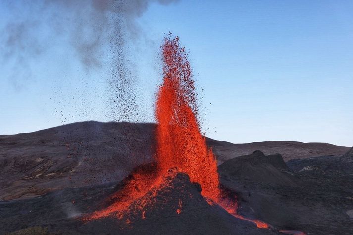
It is very notably a dike eruption. It started out as a dike several kilometers long, forming at a depth of 6-7 km and growing upwards towards the surface. A whole series of cones have formed along a kilometer-long fissure where the dike reached the surface. For a long time multiple cones would be active simultaneous, but the eruption has finally gone conventional with fountaining and effusion only from a single cone. The cones have shown a notable tendency to go double, with two lava exits close together along the line of the rift. In each twin, the cones were acting fairly independently. From the distance between the twins, we can estimate that their lava feeds separated perhaps 50-100 meter below ground. This is not an entirely stable situation, and over time one of the twins will become dominant and finally exterminate its sibling. That indeed happened in all sets of twins. The surviving cone too has extinguished its sibling.
We might have expected the dike to reach the surface at the lowest point along the dike. To some degree this happened as the eruption started in a valley. But strangely, the eruption avoided the lowest ground in the valley and it first erupted on top of the only hill within the valley. When that wasn’t enough, it went for the higher ground next to the valley. It never extended into the much lower ground further north or further south, on either side of Fagradalsfjall. There was a bit of anti-gravity about this. Why was this? Clearly, the road from dike to fissure was not entirely straightforward.
To making of a dike

A fossilized dike. Source: wikipedia
How does a dike form? Obviously, magma gets in between the rocks underground and slowly pushing them apart. The dike extends both upward and sideways, and eventually becomes a wall which can be kilometers long and tall, but only a meter or so across. It is like a very large sheet of paper, slowly making its way vertically into the crust.
Where does the magma come from? There are two parts to this question: where was the magma to begin with, and how does it get to the dike? As for the origin, the magma can either make its way up from the mantle through a conduit (as seems the case in Reykjanes), or it can come from a magma chamber that is already in the crust (as was the case in Holuhraun). That magma chamber is in most cases (but perhaps not always) located underneath a central volcano. In both cases, the magma feeds the dike from a particular entry point, and the dike grows sideways from there. If the dike is fed from the mantle, then it is also possible that there is no single conduit, and that the dike is fed from below along its entire length, but this has not been observed in practice. As far as we know, a dike starts with a bottleneck.
Why does the magma form a dike, rather than a conduit up to the surface as it does in any normal volcano? This is the all-important question. Dikes form if there is some weakness in the land. Volcanoes grow on strong land. Long-distance dikes feed on weakness, on land divided against itself. They grow best on rifts.
Let’s look at two examples. The first is, of course, Hawai’i. It has impressive, in fact world-leading, volcanoes. ‘World leading’ can sometimes have a rather subdued meaning in the US. For example, the ‘world series’ is not quite what it seems as only teams from the US and Canada are allowed to take part. The ‘world’ is not allowed to play in the ‘world series’. That’s just not cricket. But Hawai’i can and does compete with the rest of the world. Its top-heavy volcanoes are riddled with rifts, and many eruptions come from dikes following those rifts. This happened in the Leilani eruption of 2018, from a rift which was tens of kilometers long. Many of Hawai’i’s rifts follow the line of flank failures on older volcanoes. If you stand on the shoulder of giants, you also inherit their problems. The weakness in Hawai’i is very much self-induced, a consequence of the immense size of its volcanoes.
The second example is Grimsvotn. For such an impressively erupting volcano, it actually looks a bit small. Bardarbunga is far more imposing. Why is this? Grimsvotn is a child of the spreading rift that bisects (possibly quadrusects) Iceland. The rift forms a line of weakness, and it provides the magma with a tempting escape route. Grimsvotn is a young system that recently (geologically speaking) formed on the rift. It does not have a strong a magma chamber, its summit eruptions are small (although very frequent) and most of the magma goes into the rift. Laki stole its magma from Grimsvotn, either directly or by intercepting the supply. ‘My volcano is my castle’ does not work if you built the thing on a rift.
Bardarbunga once also formed on the rift but it is an older system and it has moved with the times. As the spreading rift spread, it took Bardarbunga with it and over time the volcano slowly migrated away from the rift. This made its magma better contained because it is now further from the weakness of the rift. Not perfectly, though: often its magma chamber will spring a leak, the magma will find its way to the rift, turn north or south following the spreading rift, and produce a fissure eruption far from the embarrassed volcano (who, me?). This happened in 2014. But a decent amount of magma remains confined to its magma chamber and this produces summit eruptions, or otherwise just pushes up the volcano. (Much of the growth of a volcano happens underground. Summit eruptions have their role but don’t do all the work.) So Bardarbunga grew large, while Grimsvotn with its much higher volcano-metabolism remained smaller. One day Grimsvotn too will find strength away from the rift and grow to become a giant. And Bardarbunga will have moved too far from its magma supply, and decline.
So you have magma, and you have a rift. What happens next? The magma finds it easy to push in the direction of the rift. This pushed the rocks apart in a direction they want to go anway, because it is the direction of the rifting. The magma is pushing at a nearly open door. Going in the spreading direction, perpendicular to the rift, is much harder. That requires pushing the rocks in a direction they do not want to go. Magma, as a liquid, always takes the easiest path. So the magma prefers to move along the rift, not perpendicular to it. That happens both in Hawai’i and in Iceland. In the right circumstances, the magma can travel unopposed for tens of kilometers – but only along one direction.
When a dike begins to grow, it tends to follow the line of the rift. The growth can be followed quite easily, because of its earthquake activity. The tip of the dike has to break the rock apart, and this gives a lot of small shakes – almost explosions. While the dike lengthens, it may also grow thicker, but this is mostly a silent process which does not cause earthquakes. It does not involve new breakages, just widening a crack that already exists. So while earthquakes detect what happens at the ends of the dike, the centre moves quietly and secretly.
So this explains how a dike grows long and wider (‘wide’ is the wrong word though for something that is 10,000 times longer than it is wide). How about moving up? After all, a dike doesn’t do much unless it can reach the surface.
It turns out, up is also a hard direction. Gravity complains, and when gravity has the weight of 5 kilometers of rock behind it (or above it), it is hard to go against it by moving up in the world. It is not as hard as going perpendicular to the rift, because going up pushes the rock in the spreading direction it prefers to go, but it is much harder than going along the rift where the weight of gravity does not work against it. That magma may have some buoyancy which gives a bit of a push upward, but it is still hard. So the magma can move in three directions, but they differ in difficulty. Easiest is horizontal along the rift, harder to move vertical, upward, and impossibly hard to move horizontal but in the direction of spreading. This is why dikes become like sheets of paper, and why this only happens where there is a rift to give a preferred direction.
In the absence of a rift, all directions become hard. Magma does not find it easy to move against an undivided land. That is one reason it collects in magma chamber: it is hard to get out! But physics still acts, and physics says that in such cases it is easier to move sideways than upward. In such a case it forms a sill, a horizontal dike.
As an aside, comparing Reykjanes to Vatnajokull (Grimsvotn and Bardarbunga), one thing immediately stands out. Dikes in Reykjanes are only several kilometers long, perhaps up to 10 kilometers, while Bardarbunga’s dikes can reach over 100 km from the volcano and Grimsvotn, in spite of having quite an immature rift system, also has a long reach. There are two reasons for this difference. One, there is much more magma available in Vatnajokull because it receives more mantle heat. Ten times more heat should give ten times more magma and this should allow for ten times longer dikes, all else being equal. Second, there isn’t a clear spreading rift in Reykjanes. Instead, the rifting is taken up by numerous mini rifts, located along the Reykjanes fault line. As a result, eruptions in Reykjanes are rarely more than a few kilometers from the central fault.
The topography of the surface began to play a role. For there are dungeons and dragons here, or rather, valleys and hills. Where there is a hill, kilometers down there is more weight to carry. This affects the magma dike. To understand how, we need to go back to Holuhraun.
The Holuhraun dike
The Holuhraun eruption was fed by a very impressive dike which did not play according to the rules. It ignored the straight line and followed a roundabout route. First it went east-southeast from Bardarbunga. Then it waited, and changed direction to north-northeast. There were several more changes of direction. Why?
The answer is that the direction a magma dike takes is a combination of the spreading axis and the local topography. The basic principle is an easy one: magma will always take the easiest path. This is, the path that requires the least energy. The energy is used for two things: pushing apart the rock, and pushing up the ground above the dike. The energy needed for the latter should not be underestimated. A 4-kilometer deep dike carries 12,000 tons above every square meter. Pushing this up requires a lot of energy. Pushing up the ground is easier when the ground is lower, so the dike prefers to take the direction where the ground slopes down steepest.
What if this is not the direction of the spreading axis? Then the dike will find a compromise: it will go into a direction which is not quite the spreading axis, and not quite the lowest direction, but is the most efficient. It is called the principle of minimum energy. We can calculate at every point which direction requires the least energy. And indeed, the dike took this direction at every turn. The initial ESE direction was down the slope of Bardarbunga. It reached the rift at the saddle point where it turned north. Now it followed the rift direction in general, but with various deviations. This is described by Sigmundsson et al, Nature, https://www.nature.com/articles/nature14111.pdf

The Holuhraun dike
The plot of the rift shows these changes of directions. The coloured circles below indicate at each these location the energy required for evert direction. Red is high energy, blue is low. The dike always took the blue direction. The principle of least energy really works. Magma does not like wasting energy.

Dike energy diagram. Blue indicates lower energy needs
While growing in length, the magma also tried to rise, driven by its buoyancy. It was a slow process, but once an opening had been made, the dike did not progress further but instead used the easy way, to the exit. The last stretch where the dike begins to feed the surface eruption is called the feeder dike.
Fagradalsfjall
So this is how the Geldingadalir dike (the name has a ring to it) formed. The magma quickly moved from the mantle through the lower crust, either following or triggering the series of earthquakes along the main fault. In the upper crust, 7 km deep, the magma began to move sideways, horizontally along the spreading axis. Unusually, in Reykjanes the spreading axis does not run along the main fault but goes off at angle. So did the dike. The earthquakes traced the tips of the dike, which as expected moved towards the south coast in one direction and towards Keilir in the other direction. The earthquakes gave the impression that the two tips of the dike were primed for eruption. But that was misleading. The tips of the dike remained at a depth of 4-7 km. Instead, most of the magma that entered the dike was used to bulk out the central region. This bulking up was aseismic, although not invisible: the growing dike was seen on the interferograms which showed local inflation and extension, and those indicated where approximately the actual eruption would take place. Of course, hindsight is always 20/20.
The Geldingadalir dike feeling its way towards Keilir was small, but it followed the same physics as the Holuhraun dike did. The map shows the line of earthquakes which traced the dike. I took this from a plot showing the locations of earthquakes between Feb 24 and March 12: https://twitter.com/krjonsdottir/status/1370280535050878980

The dike is shown by the orange line. The location is not exact but is taken as the approximate midline of the earthquake activity While moving north and south, the dike made a small change in direction, and at one place going south there was a bifurcation and the dike (as traced by the earthquakes) backtracked and went into a slightly different direction. The point of bifurcation is uncertain: it might be a bit further to the south.
One would expect the dike to follow the spreading axis. The spreading axis in Iceland runs nearly north-south (about 10 degrees east of north). However, the land itself is also moving. If you take the direction relative to the (moving) plate boundary, the axis becomes more eastward, and follows the line of the obvious volcanic ridges on the Reykjanes peninsula. This direction is shown by the blue dashed line. The northern section of the dike indeed closely follows this direction. The land here has only a small slope towards the northern coast. The cost of gravity varies very little with direction and the dike is completely dominated by the spreading axis. But this is not the case underneath the mountains of Fagradalsfjall, and here the dike chose a different direction. It avoided the peaks of Langholl, Kistufell and Storihrutur (where the cost of gravity would be high) and followed the lower ground in between. The peaks here are far smaller than the mountains of Vatnajokull and the effect is less than seen in Holuhraun. But topography still matters.
Sometimes a dike takes a wrong turn. One of the two southern branches ran into a high ridge, found no way out and terminated. There was not enough energy to continue in any direction. This caused a bifurcation: the alternate channel found a way into the deep valley of Natthagi, and ended there. Towards the north, the dike ran into the large cone of Keilir. This also was an unsurmountable obstacle, and the dike could neither go through or go around. It terminated here.
Underneath the mountains, the direction is always a compromise between the spreading axis and the topography. We can largely understand why the dike took the directions it did. The only surprise is that it crossed a small ridge but this ridge is quite narrow.
The best route also depends on where the dike first formed. If it had formed along the southernmost segment, the preferred route would have been directly into Natthagi and Meradalir. If it had formed north of Kistufell, it would have gone only to the north. The most likely place for the first magma intrusion is therefore along a line between Kistufell and Langholl, to a point left of Meradalir. This is indicated by the blue oval.
The dike and the fissure
How does this compare to the fissure? An excellent Landsat shot of the series of cones (and lava flows) has just appeared, showing all 6 cones.

The series of cones follows the direction of the main dike quite well. However, the fissure is offset to the west by about 200 meters. I measured this several times but could not get the mid-line locations to match. Between the deep dike and the surface rupture, there is a slight tilt. This seems problematic: it is a principle of geology that dikes are vertical and do not tilt. Perhaps the dike is not quite at the central line of the earthquakes, the dike has a few more small but unrecognized changes of directions that bring it in line with the fissure, or the fissure is not actually the top of the dike but there is a tilted conduit between them. Most likely, of course, is that I did not get the measurements quite right.
There is one further surprise. The dike will find it easiest to erupt at the lowest point, where there is the least amount of rock to melt through. The eruption happened close to the point where the magma came up from the mantle. Meradalir would have made a good eruption point, being a deep valley, but the dike bypassed this. The next lowest point was the valley of Geldingadalir where indeed it erupted. But in this valley, there is a small hill. Strangely, it erupted near the top of this hill. The later cones similarly avoided the deepest valley and went for the higher ground to the north. This remains unexplained. For some reason, the hill was a weak spot which allowed easier access to the surface for the feeder dike. We will come back to this.
The Reykjanes fault
The Reykjanes fault was crucial to the development of the dike. This was the fault that initiated the immense swarm of earthquakes which announced the eruptive intent. It gave way in several M5 earthquakes. This fault is mostly a transform fault. The south side is moving east relative to the north. The interferogram shows the movement beautifully. Red (eastward motion) delineates the fault perfectly.

Let’s put this on the map. Here is the map of the dike and fissure, on top of the digital elevation model. The black line shows the Reykjanes fault, as traced by the area where the surface moved to the east. There are slight offsets along the line but I have ignored those. The white lines shows the region of earthquake activity along the fault in the weeks leading up to the eruption. These were largely aftershocks of the main earthquakes where the sides of the fault made small adjustments with minor failures. The dashed white line shows the location of an earlier series of earthquake which happened in 2017. The earthquakes were seen in an area north of the surface motion.

The fissure is closely related to the fault and the fault earthquake zone. The fissure terminates on the fault itself and did not cross the fault. This eruption belongs to the North American plate and did not manage to cross into the European plate. Interestingly the dike had no problem with this and happily crossed over. It seems that at depth (hotter rock) the plate boundary is easier to cross.

The circled feature is close to where the Reykjanes fault is located, and perhaps traces the surface rupture of this fault. Source: Lughduniense
The second point to note is that the length of the fissure largely coincides with the width of the fault earthquake zone. This eruption occurred where the dike crossed the fault crumple zone. It made use of the weakness of the rocks in this area.
This immediately show the importance of the Reykjanes fault. The fissure similarly began exactly at the fault line, and extended northwards from there.
That hill

The early days: the cone on the hill
When the eruption began, the first fissure followed the ridge of a small hill in the Geldingadalir. The origin of this hill was not clear. It was not a result of an earlier eruption. It may have been glacial.

Step-over faults
However, the location close to the Reykjanes fault suggests another possibility. The Reykjanes fault may have step-overs, where the fault consists of segments which are slightly offset. This is very common for faults that are young and still in the process of organizing themselves. An offset in a transform fault can cause conflicting movements. The step-over can cause either cause compression or extension in the area in between. In the first case, a pressure ridge can form a small hill form in the area of the step-over. I speculate that the hill of Geldingadalir is (was) a pressure ridge: it is the location of the transverse fault where at one time a small step-over occurred.

Pressure ridge along the San Andreas fault. https://www.flickr.com/photos/rwolf/48004993242
Pushing this speculation a little further, the transverse crumple zone may have given the magma the easier pathway to the surface for the feeder dike. This would explain why the fissure ran along, an in fact started on, the ridge of the Geldingadalir hill.
Where pressure ridges occur, you can also find sag pools, or small basins, where the fault pulls the crust apart. Was Geldingadalir itself such a depression? This is becoming even more speculative.
Extension
The Reykjanes fault is more than just a transform fault. There is also a bit of extension here, a little bit of spreading. The sides of the fault slowly pull apart. If I am allowed to speculate even further (we are getting on very thin ice here), the notably deep valley of Meradalir could be a result of this extension, as a small pull-apart basin approximately along the line of the fault.
Can I see any evidence of the movement of the fault? That is notoriously difficult. It means finding features in the landscape on either side of the fault, and matching them up. But landscapes evolve and the two sides may not look alike any more.

I can attempt this for the ridge that separates Meradalir from Geldingadalir. It continues across the fault but the appearance is quite different on either side of the Reykjanes fault. Perhaps this isn’t the same ridge? There is another ridge a bit to the southeast which looks more like it. If I shift this ridge according to the spreading direction and transform movement, the two ridges line up fairly well. The offset is some 700 meters. Assuming an average movement of 2 cm per year, this makes the ridge 35,000 years old. The offset nicely delineates Meradalir which becomes a small pull-apart basin. The ridge would have formed during the depth of the ice age.
I can push this further. On the south side of the fault, there is an eroded plateau which lies just south east of the ridge. There is no such plateau on the north side of the fault. There is however one on the west side of the area: the high plateau of Fagradalsfjall. Could that be the same plateau? In that case the offset is around 2 kilometers. The age of the plateau would be 100,000 years. Was this a shield eruption? The lack of ridges would imply there was no ice when it formed. And indeed, the time is close to the last interglacial when Iceland was ice-free.
This is deep speculation, in severe need of data, even if those data may well show it to be in error. Lots of handwaving involved! But the ages make sense. The Geldingadalir eruption came in an old landscape which had seen little or no volcanic activity for tens of thousands of years. It is a unique event. We are very lucky to have seen geology in such action in our life times. The last time this happened, we were still into cave paintings.
Albert, May 2021


Nice videos in this account from 5 days ago, big lava-cascade to meradalir.
https://youtu.be/JgprbBuDdlw
https://youtu.be/19b-zZcdcHo
Wow that is impressive!
In a way, that kind of reminds me of glaciers and how they move.
Nice videos. Thanks for spotting them!
I’ve been contemplating the comparison of volcanic processes to othe watre-based geomorphological processes and the resultant landforms. I may need to work a piece up on this theme.
That is, if I ever get time from house management and house elf duties, hospital taxi service and first aid psychology, gardening, compost production, decorating and house organisation/modernisation. My latest project is gusset knitting. I need a scullery and laundry maid at the very least….
Now that he has starved his entire family to death, Vent#5 (Hannibal) seems poised to pour hot lava down his dead parents throats. Somebody has to stop him before it’s too late!
This was a few days ago
https://apps.sentinel-hub.com/eo-browser/?zoom=13&lat=63.88785&lng=-22.29564&themeId=DEFAULT-THEME&visualizationUrl=https%3A%2F%2Fservices.sentinel-hub.com%2Fogc%2Fwms%2Fbd86bcc0-f318-402b-a145-015f85b9427e&datasetId=S2L2A&fromTime=2021-05-04T00%3A00%3A00.000Z&toTime=2021-05-04T23%3A59%3A59.999Z&layerId=2_FALSE_COLOR
and today. You can see the extension towards the top. (the adjacent black bit is a fire)
My little Puffy Fumarole is still steaming away in the face of the onslaught of Big Brother (Hannibal?) see to the far right just above RUV.IS
https://www.livefromiceland.is/webcams/geldingadalur—volcano/
As to wild fires I could imagine they would be similar to those on the Pennine Moorlands near us. No trees but the vegetation consists of short reeds , being the tallest, Heather, Moss and Lichen. These grow in peat ,which of course burns hot and slow once ignited. In Iceland there is probably similar and the very long lichen called Reindeer moss that becomes very dry and brittle when dried out. Our moorland wild fires burn for days due to the super heated heated peat.
Not like. We also have similar fires on heathland in the Ashdown Forest, home of Christopher Robin and Winnie the Ppoh.
We have them every spring when the local pyromaniacs decide to cut back the heather. Its called the Muir Burn and slightly disturbing to have to drive along a single track road with burning vegetation and even fences on both sides.
There is a lava flow in the background of the live video, that seems to bubble and be restless off and on. Just wondering if anyone else has noticed that as well.
I found this video, with a fissure opening on Pacaya volcano, Guatamala , bears watching,
+https://www.youtube.com/watch?v=d6wgLNap6_s
this video is longer most likely the same
Beautiful piece by Carl abou Guatemala from 2016:
https://www.volcanocafe.org/the-new-decade-volcano-program-the-missing-volcano/
Christ the scale is terrifying. Fortunately the flows are relatively slow moving. Beautiful outpourings.
You wouldn’t want to have to run fast from the lava on that terrain. Broken ankles all round. 😮
There were some spectacularly beautiful bursts last night. This is from about 13 minutes after midnight
i saw it ‘live’ and thought Cherry Dessert! and happened to be drinking a cherry fizzy drink. Some consulation living on the far side.
I’m curious as to the red dots in Meradalir on the satellite images; the northernmost is there in both images. Is that possibly the exit of a lava tube? Or where the stream hits some kind of obstruction, causing turbulence? Also, forgive my ignorance, but watching the river flow down the slope & the lava front advance, it doesn’t seem to show the surges of the vent. I appreciate that it’s had time to cool a bit & smooth out, but is it also possibly being fed continuously from vents underneath the lava surface in Geldingadalir? Which could explain the regularly-steaming spots, too, as gas escapes above a hidden vent? Sorry if these are idiotic questions; I’m a regular reader of long-standing, since before Bardarbunga, mostly because I think volcanos are beautiful & interesting, if also potentially deadly, but also, always seeking to understand.
I had noticed the same: the first part of the lava river shows surges after an explosion, but the slope down into the valley does not. The surges fade just where the steep section begins. A spatter cover could explain that, or there could be a smal lava lake that absorbs the surges and smooth them out.
Regarding the red spot, my guess is that these are small lava falls. But that is guessing
Hi out there.. Have anyone seen a good drone video of in the lava pond/lake between the outbursts.. Even it is so nice look at, for me would be very interesting see how it behave just after and on the build up.. Ok coffee..
https://www.youtube.com/watch?v=3N0benwDTD4
Artificial Pele’s hair 🙂
I am assuming these are moss fires, but the smoke has become so dense in the foreground so you can barely see the crater anymore.
https://www.youtube.com/watch?v=I1I-0PUhFmU
Did it just change behavior or.. Very mild outburst and longer.. ?
At 08:58 there was a massive fountain (the biggest I have seen). Seems to have affected underground, there are now two vents open in the crater. Check the Langi-cam
Agreed, the 8:58 fountain was spectacular. The view from the RUV Geldingadalir camera was also quite clear at just that time.
I see there is continuous low fountaining in both 5A and 5B, now. I’m assuming that the two sub-vents of 5 correspond to the original two vents in this location.
Could this be the end of the episodic high fountains?
Maybe not the permanent end to high fountaining but it is a very interesting development. I did see looking that the wall caved in on the back as often happens, but this was quite a big collapse. I think it filled in the lava lake basin so that when the lava returned it was not ponded over the vent anymore which is what was driving the fountains, extreme gas pistoning.
The second vent is interesting, maybe it is the old twin vent (the ‘rag’ half of ‘Ragnar’ as it was called) or maybe it is a new vent, but it seems closely related to the main one i nany case, so probably not any more likely to see new ones open further afield than before, we will see though 🙂
It is something to note that Pu’u O’o and Mauna Ulu did stuff like this many times without terminating their high fountaining episodes. Pu’u O’o in episode 11 even rifted open as a curtain of fire half a km long going right through its cone, with result of one of its biggest and fastest flows of that era, and episode 12 a month later was similar, though instead of a fissure eruption it stayed in the crater and a dike several km long went east even beyond the length of its original eruptive fissure. Episode 13 however was ‘just’ another high fountain through one vent as though none of that ever happened, vents come and go just like that.
HVO has also said they found no particularly good reason why Mauna Ulu stopped fountaining other than the vent was naturally eroded by such activity, if it narrowed at any time later high fountaining would have resumed, it almost did in the final month of the eruption actually. Kilauea Iki also did something like this in its episode 4, a low fountaining effusive eruption that is also the lava temperature world record, but episode 5 a day later was another lava geyser high fountain.
This is of course way more rapid succession, episodes separated by minutes instead of days to months, but same principal is there. If the cone builds up and impounds a lava lake at the vent again I think fountains will resume.
Great Scott! That’s incredible! The folks on the hill must have felt rather nervous with that in front of them.
It appears to have changed the system – or the system changed with that.
We seem to be back to continuous flow in the active vent. And there’s smoking from the nearby original vent (though that might be from spatter from that enormous outburst?)
And in 09:08 from the RUV Langihrygger cam, there is a fall of lapilli in front of the camera!
From that distance.
As at 9:55am, Nordri is alive again.
There is a bit of spattering activity happening in that vent, now.
Hard to see inbetween all the smoke, though.
The first reissue of lava from Nordri appears at 9:49:21.
The big fountain came through a very narrow nozzle, from how well focussed it was. I would guess that the back pressure wave broke through the nordri blockage.
There were some large wall collapses this morning, though I forget whether they came before or after the large fountain and have to go out now so I can’t look for them.
It’s also possible we are seeing an uptick in eruption volume, since the outlet river is overflowing its banks in several places.
As it turns out too the last of the high fountains in this sequence was also the tallest just over 400 meters tall, and above the base not above sea level.
https://imgur.com/a/tR9Lv0m
The lava channel has started to overflow like a flood from hell too, lava rapids near the bottom of the hill, its moving fast..
https://www.youtube.com/watch?app=desktop&v=I1I-0PUhFmU&fbclid=IwAR0BY3wjmpoGODRFz-ucI2iz-iHsWbswt2CtxUhgWDqVCfvQMRkf2_hRZgU
Webcam looks like its turning into a slosh spatter vent .. I like the low fountains and bursts.. because it looks so fluid! It looks like littoral Kilaūea bubble bursts. Many low splashing in this fagradalshraun been looking like glowing paint
It looks like there are at least 4 vents in the crater, the single vent must have been plugged by the big slide. It looks like the vent on the side of the crater has stopped though it is only spattering a bit now.
From about 9.15 today the faf high pass drum plot has gone back to steady vibration as opposed to the pulses of the last week. Backs up that something has caused the behaviour change.
Anyone got the tremor plot? Has the blue line steadied out again from the same time?
Found it. Looks like the tremor has jumped back to before the increase. I think. It’s a bi hard to see on the right hand side
Experts call – is this a decrease in activity or just a signal that flow is less interrupted so causing less friction?
Was looking at the video today and the sheer size of the vent now suddenly struck me. The flow looks the same inside the vent, but given the vent must be several times larger than the original vents, the flow must be higher to look this way. Has anyone else had that feeling?
Does look higher than it was early in the eruption, this cone is gigantic next to Bob, or whatever it is called, the first one 🙂
Official numbers are that the eruption rate is around 7-8 m3/s, which is the same as it has been since fissure 2 opened, but now and for the last week it has all been forced through one vent again instead of as many as 8. The cone is 90 meters tall if that gives any scale. Personally I think the effusion rate has gone up, not a lot, but its definitely way higher than it was a month ago and it looks like it is sustained at the same rate it would achieve in fountains yesterday, only those were episodic and not continuous.
The lava flow is also moving mostly to the south now, a lava boat blocked the cannel, but the channel overflow actually began before that around the time the fountains became continuous, so I expect there was an increase in effusion rate.
Wow… 90 meters tall! thats a true mountain if placed in an avarge boreal forest.
The large cone… 90 meters tall? then a human… is tiny in comparison..
It certainly looks much smaller.. but volcanic spatter heaps… does not look like mountains either…
The fountain at 8:58 was 410 meters tall above the vent, and the cone is around 1/5 of the height of the fountain, so maybe closer to 80 meters than 90 but still it is a proper hill now. Its as tall as the cone made by Holuhraun.
Just had another look. The tremor plot has definitely calmed down loads now.
Also just watch the Reykjavik Grapevine #100 and the noise from the volcano was amazing to hear. As well as the view from the hill and the fact that you can feel the heat. It put the size and reality much more in perspective.
Tiny humans ..
If you look at the ridgeline opposite RagNar you can see
all the humans ( ants ) on the RUV.is cam ..
https://www.youtube.com/watch?v=BA-9QzIcr3c
It gone back to steady mode after the new vent had opened at 9 20 inside the crater.
Has anyone figured out how we can get a better look at the 3 or 4 smoking areas behind the active cone on the west?
Short of hitching a ride on the helicopter that keeps hovering over the valley at the moment, I’m not sure how to.
The Geldingadalir camera has just showed lots of smoke but no fire.
Two timelapses from the mbl overview camera.
Each starting at 17h10, the slow one ending at 9h15, the fast one ending at 11h15
The scenic version (very slow but worthwhile for the changing weather, seeing the huge rocks floating in the morning and the big fountain around 9 am) (1 second = 1 minute)
https://youtu.be/EBTzI8NltIE
And the fast version, where the rock frigate seemingly navigates it’s way through the lava river until it breaks up and shows why the lava river diverted a bit for a while (1 second = 10 minutes)
https://youtu.be/k93gVd3opqE
Thank you!
Words cannot express my gratitude for these timelapses. Mundane reasons meant I didn’t check in yesterday and the episodes had disappeared from the live feeds by the time I did look. It ends, like so many dramas, on a cliffhanger; I look forward to the next one, to finish the overflows. Brilliant work. Thank you so much.
Is it my imagination, or has the flow increased enormously? Looking at the 2nd MBL camera (wide view) at around 16.12 UK time.
Sure the flow is healthy. Overflow moved to the end of the superior part. Rock walls helping the overflows.
Good view now here:
http://brunnur.vedur.is/myndir/listi/webcam_langihryggurN.html
Could it be that Ragnar “wants to pulse” and will do so by building a new splatter cone (within the old) restricting flow, increasing pulsing, blowing himself out and then start the process anew?
Is there any evidence for Nordri coming back to life? The giant geysir of 08:58 splattered it, and I felt that it was large splatter that smoked for a while.
no activity…..at least tonight will see any orange glow of this for true. but I hink that’s extict for time been
09:49:20 https://www.youtube.com/watch?v=7-RhgB1INII
A flow of lava is definitely visible.
So it is! How did I miss that? Thank you!
Once night falls hopefully we can catch up with Nordri.
I haven’t seen much activity since. I suspect it may have been a response to an over pressurised system and now that the equilibrium has been met it has gone back to sleep. Until the next time whenever that is!
There is/was a lava stream coming out. First bit I can see is at about 10:06ish.
Still some coming out at 10:30, not checked much further than that.
The chinese rocket is now expected to crash tonight. Areas at risk include a lot of ocean, Australia, Africa and north and central america.
https://twitter.com/AerospaceCorp/status/1391049770588729345/photo/1
if it lands on my Vegetable beds, will I be able to claim compensation? It’s taken a while to get my courgettes growing in this cold Spring!
I believe you can. But the UK is too far north for the orbit
Shame. I’ve a garden fence that needs knocking down.
And on Mars Ingenuity arrives over its new landing zone and ascends to a new record height of 10 metres to take some more colour imagery before landing at its 2nd base.
Closer up look safely on the ground after flight 5. Ingenuity is now officially “Operations Demonstration” upgraded from previous technology demonstration.
And for those who missed it here’s the video with sound recorded by Perseverance from flight 4. Best with headphones or decent speakers.
Off-topic and still about space/ Mars:
Some scientists think that they have uncovered evidence of life of Mars. Specifically some sort of fungal-like life formd measuring around a few mm.
It could be still an unknown geological abiotic mechanism, but it is certainly very interesting.
Is this a groundbreaking historical paper?
https://www.researchgate.net/publication/351252619_Fungi_on_Mars_Evidence_of_Growth_and_Behavior_From_Sequential_Images
We will have to analyse the chemical component of those things.
I wouldn’t be surprised if there is alien fungal-like forms on Earth.
I suspect the universe is full of life forms.
IMHO most likely is in the clouds of Jupiter. The colour striping along the equatorial zone looks very much like life generated. Plenty of chemistry and adequate light.
I haven’t followed the Fragadalsfjall eruption for nearly 3 weeks as I have been working in a remote location with little internet. Could anyone please make me a brief summary of what has happened since then? The main vents erupting (as compared to the initial 2 vents) and lava running fast into the surrounding lowland valleys.
Slow effusion, growing lava field, lava spilling over into the next valley, new fissures opened, old fissures stopped as activity focused on a single vent. The best part was from may 2 up until this morning when the single active vent had episodic high fountains with very little action in between. 3-4 minutes of high fountains, then a pause, repeating on a 10 min schedule. The high fountains sent ejecta out in the terrain and started moss fires that looked like new fissures opening. After a lot of debate I think we finally ended up with consensus that it was indeed only burning moss. Last high fountain was the largest of them all and happened around 9 this morning. Now it is back to steady slow effusion again.
You forgot the arctic fox! 🙂 And the ~400m fountain this morning that reset everything: https://www.youtube.com/watch?v=S_B0ji5dnwo
Total of 8 vents at one point up to the end of April, then it settled at vent 5 which is about exactly where the old mbl.is cam was buried. First continuous lava river flowing out of Geldingadalir, then it became a lava geyser, then it stopped but not before blasting a 400 meter fountain. Now its continuous again but seems higher than before.
Actually after 9 hours the lava geyser has restarted, as though nothing happened at all 🙂
Would seem that it was entirely due to the crater being partly filled in by a wall collapse that stopped the fountains, now the basin has been formed again theres ponded lava and the geyser has started up.
Quake swarm on Bardarbunga…
Looks to be around the location of the depressions that formed when the dyke was tracking in 2014, close to Kverkfjall.
This is where the dike turned and it’s a common place for swarms of deep quakes. Here at VC it’s called Greip (unofficial name). You can find lots of discussion in old articles and comments.
Probably Icequakes, but worth keeping an eye open.
Depths between 24.3km and 9.8km, except for a 1.1km (which I believe is the default for an unconfirmed depth). More likely an intrusion at depth.
Crater going off again. 21.12 second time i have seen.
21.15 big flow and fountains
21.12!? We have assumed control…
Before you start questioning how that happened… be aware that some Dragons are also Rush fans 😀
I stared… and thought “but I didn’t…” 🤪
A new eruption is beginning from the first crater in Geldingadalur
https://www.ruv.is/frett/2021/05/08/strokavirknin-i-gosinu-haett-og-nu-gys-ur-elsta-gignum
How did this story ever make it into the news? After checking all of the cameras today, I couldn’t find a trace of lava issuing from the first spatter cone. There appears to be a tiny bit of smoke/steam high up on the cone but nothing more.
It definitely did happen and was commented on at https://www.volcanocafe.org/the-ballad-of-ballareldar-the-dike-the-fissure-and-the-fault/comment-page-4/#comment-61982
There was quite considerable flow on the RUV cam for a time but it stopped again.
Thanks for the explanation. I checked the Mila time-lapse of the RUV Geldingadalir Webcam and could see a small flow on 2021-05-08, around 9:50, that lasted only a few hours. I missed it when I went through the time-lapse earlier. It seems a stretch to call that an eruption, more like a trickle.
Looks like lava geyser mode is back on.
Yes i noticed a nice fountain a while ago. I think it the Trolls and Gnomes playing tricks on the Tourists!
https://k100streymi.mbl.is/p2p/webcam1 shows another hot lava shower at 22:30, so maybe we’re back to pistoning on this cone vent, and renewed eruptions for the original north cone.
I haven’t seen any activity in the original vent. There was some steaming and incandescence right after it was completely sprayed by the last huge fountain, but after that it seems silent.
The pistoning action is evident when looking at the tremor graph and drumplot.
So the blue line on the tremor plot reduced right back down after the big geyser this morning and the high pass drum plot stopped pulsing. It’s now reverted to the wide band, but the drum plot is not pulsing.
What’s going on here then? Is it something new?
The drum plot is pulsing, but each pulse is a bit longer than they were before so it looks a bit different now.
OK, I give up. I am beginning to believe the Fagradals eruption is a cunning test by Carl to see who has been paying attention on the Cafe. There are now so many different modes of seismic activity and volcanic eruptive styles, I’m losing count.
Has this now gone back to continuous flow? The geysirs appear to have stopped once more. Puzzled.
Sorry, I mean the ‘pulse’ style of eruption. Ugh, it’s getting late here.
Cross-caldera GPS at Kilauea is increasing again. The eruption there is also now very small, looks like the pressure is building and we will see a new eruption there soon. The GPS has already recovered to the point that things began to break in 2020, and the south flank movement shows no increase that would give a false signal.
Pu’u O’o has also deflated with nothing to do with the summit, I dont know why, it seems that magma west of Pu’u O’o drained a bit, probably downrift slightly.
The shrinking of Pu’u’o’o was a sudden jump. That may be a problem withe the instrument. Otherwise it has been pretty stable recently. Kilauea is pretty much where it was before the Dec 2020 inflation. If the trend of the past few days continues, it would seem to indicate a possible new outbreak. It does the same as it did then. But it needs a bit more time to see whether this is a trend or a fluctuation. The current fissure seems to be closing – perhaps under the weight of the lava lake? A new fission could be (but doesn’t have to be) in a quite different place. Pure guess work: the GPS movement is strongest south of the caldera, so worth keeping an eye on this rift zone.
The Pu’u O’o signal actually shows at a few other instruments nearby, it does seem to be real, but probably not consequential, or eruptive.
I more expect a surge in the ongoing eruption than a new vent, at the rate of inflation today it will take maybe only another week to reach the value that caused the eruption in December, so things might change quickly. If the vent plugs a new one will probably not appear immediately but one will form within months if not weeks, probably with rapid effusion and significant crater filling, generally speaking 0.2 km3 a year is probably the average right now and we are just under 1/4 the way there yet already close to half way through the year, theres a lot of magma that isnt getting erupted.
Looks like Halemaumau vent… turns into s shield vent on top of the thick rottless lava lakes crust…. coud easly form… a little overflow shield on the crust there…
But it will likley crust over completely… and a 400 meters fountain later in autumn
I have been carefully watching the https://www.ruv.is/sjonvarp/beint/ruv2 camera for the last 20 minutes or so, through 3 gusher cycles of the active cone. It is now 04:26 am. I have noticed that in regard to the smoking area which is to the right of the active cone on this picture, when the cone is gushing, very light phosphorescent pillars of smoke in about 6-8 spots rise up in this linear stream of smoke. In the last gush, around 4:24 am, there was another area of smoke next to this line, which appeared. I also noticed that this stops and the smoke goes back to its languid behavior when the active cone is quiet.
This has caught my attention, obviously
And the rythm is back again.
Regarding tremor plot of MER station which I belive that is Meradalir…..
http://hraun.vedur.is/ja/oroi/allarsort.html
What is mean the y 8000 limit? wil be exceded soon…
And of course what it means that constant linear increase of the upper graph on blue. Which is a common behaviour for all stations that reflect the eruptive status.
What means the green line which copy the blue line behaviour and why not is happening similat to the mauve line?
I’ve been wondering the same.
https://www.youtube.com/watch?app=desktop&v=I1I-0PUhFmU&fbclid=IwAR0BY3wjmpoGODRFz-ucI2iz-iHsWbswt2CtxUhgWDqVCfvQMRkf2_hRZgU
Cyclic fountains are back webcam
This eruption coud last many years, as its feeding itself by decompression melting.
I get the picture of a slowly deflating Earth, like a balloon going down… 🙂
“The hulk of the Chinese Long March rocket reentered Earth’s atmosphere around 10:30 p.m. Eastern time and some debris landed in the Indian Ocean near the Maldives, China’s Manned Space Engineering Office reported late Saturday night, ending days of international speculation. There were no immediate reports of damage from falling debris.” From Washingtonpost.
https://www.youtube.com/watch?v=5iRmyXdPEWs
lava visual analise please!!!
I always wonder why on the extinct nr.2 there is a white vein and on he old twins there are red spots…
https://www.mbl.is/frettir/innlent/2021/05/08/allt_odruvisi_i_dag_en_i_gaer/
old twin photo proof that was active a little…I guess that was in same time with the parasite vent from the bigest one that was yesterday…
what valley is the lava currently flowing into ? mera..? or geld..? Hard to tell from current webcams and with the sunlight out
Flow goes into Mera at the moment. It’s about to exit into next part shown on cam, down in the left corner.
Pictures are big, so it loads slowly.
http://brunnur.vedur.is/myndir/webcam/2021/05/09/webcam_meradalahnukurSSV.html
If you compare the images taken 1 or 2 days apart you can clearly see the filling of meradalir


Today 1200
Friday 1200
Mars Guy is Dr. Steve Ruff, an associate research professor at Arizona State University.
Not sure if this was noted earlier, but a good portion of the fragmented rim on the rear and right side of the crater collapsed spectacularly starting at 8:33. Prior to the collapse, lava can seen starting to ooze out of the sidewalls near the top of the rear rim around 8:30. What this is indicating is the crater walls are filled with lava…perhaps a small offshoot vent…which I think may be the second (new) vent folks have posted about now that the slide has revealed it.
Hi, another timelapse from the mbl wide angle camera from yesterday afternoon to this morning.
From it’s continous phase back to it’s pulsing cycle (though it takes a while to get regular)
https://youtu.be/944L_pouqyc
Each second is 4 minutes.
This icelandic eruption is going to last many years … Chads ”Hell Machine” is at play here
Eruption is feeding itself by decompression melting
my new screen saver pic:

click on image to expand..
What cam is that?
not really a normal cam, takes a long time to load, html, containing last 24 (?) hours of images:
http://brunnur.vedur.is/myndir/webcam/2021/05/09/webcam_meradalahnukurSSV.html
It’s a still cam, updates every 10 minutes. There is a new page every day. The list of all of them is here, scroll down a bit.
http://brunnur.vedur.is/myndir/listi/
This URL not need changing dates, from midnight :
http://brunnur.vedur.is/myndir/listi/webcam_meradalahnukurSSV.html
The other:
http://brunnur.vedur.is/myndir/listi/webcam_meradalahnukurSV.html
The north cone is now erupting in unison with the active cone now. I wonder where this is heading? Will we see activation of the other quiet cones? See https://drive.google.com/file/d/1I7cH4B1Q81naFTjJ-Wf_apZXYoDBpa_1/view?usp=sharing which is the 19:35 pm cycle.
i prepared to believe it buy i don’t see eruption from the north cone on this…. where should i look?
buy/but
https://www.ruv.is/sjonvarp/beint/ruv2
not sure if it is distinguishable in the night time.
I dont see any lava from Bob, there is lava flowing in Geldingadalir but I think that is from the interior of the ponded lava put there over the last month and being squeezed out by the weight of the new cone growing on top of it, rather than a new vent. There is also a rootless lava flwo that appears when the fountains fall into the hole on the side of the active cone, and that flows into Geldingadalir too, but its not large volume long term, so I dont think it is a source.
I did see the lava at Bob the other day, that looked real, but I dotn think it is actively erupting at regular intervals or someone probably would have taken a video of it by now, or put a live cam up to watch that area again.
On the far left of the Geldingadular cam there is a small light ,seems to be the same colour as lava-as oppose the white light from humans walking about,been there a few hours,anyone else notice?
Second thoughts, forget about it, am thinking human activity of some sort!
Just my imagination…or is the South quadrant of Ragnar’s cone sliding into the Original twins? Too much heat heat building up, cone foundation becoming molten? Can Ragnar no longer support a cone?
It is sliding down, probably because that side was built over the new lava which is something like 40 meters thick and still molten inside. The lava flows that are active in Geldingadalir now I think are because of this still liquid lava being squeezed out, not because a vent is active somewhere and feeding it.
Its also common for these sorts of cones to have massive slow failures, they are not entirely solid, and on a long timescale can sort of behave like a lava dome including on occasion having huge rootless blocky lava flows as the structure collapses under its own weight. On Etna earlier this year where this has happened on a steep slope these spatter flows even collapsed into pyroclastic flows just like on a silicic lava dome, shows how in reality these seemingly very different forms of volcanism are actually not so different after all.
For unclear reason all your comments are put in the ‘for approval’ queue. I’ll pass this on to the real dragons as needing an urgent fix – a lesser dragon
interesting…old twins could be engulfed in lava hot field….maybe then will be a steady reopenig vent?