This is quite an eruption, with surprises with every new turn of events. It is an unusually tourist-friendly eruption: conveniently located, small, non-damaging (except to the owner of the land) and spectacular. It does appear that not all tourists are as friendly to the virtual tourists, judging from the antics going on in front of the cameras, but that is what it is. Even the local foxes have been photobombing the eruption.
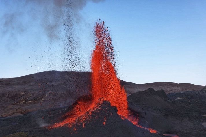
It is very notably a dike eruption. It started out as a dike several kilometers long, forming at a depth of 6-7 km and growing upwards towards the surface. A whole series of cones have formed along a kilometer-long fissure where the dike reached the surface. For a long time multiple cones would be active simultaneous, but the eruption has finally gone conventional with fountaining and effusion only from a single cone. The cones have shown a notable tendency to go double, with two lava exits close together along the line of the rift. In each twin, the cones were acting fairly independently. From the distance between the twins, we can estimate that their lava feeds separated perhaps 50-100 meter below ground. This is not an entirely stable situation, and over time one of the twins will become dominant and finally exterminate its sibling. That indeed happened in all sets of twins. The surviving cone too has extinguished its sibling.
We might have expected the dike to reach the surface at the lowest point along the dike. To some degree this happened as the eruption started in a valley. But strangely, the eruption avoided the lowest ground in the valley and it first erupted on top of the only hill within the valley. When that wasn’t enough, it went for the higher ground next to the valley. It never extended into the much lower ground further north or further south, on either side of Fagradalsfjall. There was a bit of anti-gravity about this. Why was this? Clearly, the road from dike to fissure was not entirely straightforward.
To making of a dike

A fossilized dike. Source: wikipedia
How does a dike form? Obviously, magma gets in between the rocks underground and slowly pushing them apart. The dike extends both upward and sideways, and eventually becomes a wall which can be kilometers long and tall, but only a meter or so across. It is like a very large sheet of paper, slowly making its way vertically into the crust.
Where does the magma come from? There are two parts to this question: where was the magma to begin with, and how does it get to the dike? As for the origin, the magma can either make its way up from the mantle through a conduit (as seems the case in Reykjanes), or it can come from a magma chamber that is already in the crust (as was the case in Holuhraun). That magma chamber is in most cases (but perhaps not always) located underneath a central volcano. In both cases, the magma feeds the dike from a particular entry point, and the dike grows sideways from there. If the dike is fed from the mantle, then it is also possible that there is no single conduit, and that the dike is fed from below along its entire length, but this has not been observed in practice. As far as we know, a dike starts with a bottleneck.
Why does the magma form a dike, rather than a conduit up to the surface as it does in any normal volcano? This is the all-important question. Dikes form if there is some weakness in the land. Volcanoes grow on strong land. Long-distance dikes feed on weakness, on land divided against itself. They grow best on rifts.
Let’s look at two examples. The first is, of course, Hawai’i. It has impressive, in fact world-leading, volcanoes. ‘World leading’ can sometimes have a rather subdued meaning in the US. For example, the ‘world series’ is not quite what it seems as only teams from the US and Canada are allowed to take part. The ‘world’ is not allowed to play in the ‘world series’. That’s just not cricket. But Hawai’i can and does compete with the rest of the world. Its top-heavy volcanoes are riddled with rifts, and many eruptions come from dikes following those rifts. This happened in the Leilani eruption of 2018, from a rift which was tens of kilometers long. Many of Hawai’i’s rifts follow the line of flank failures on older volcanoes. If you stand on the shoulder of giants, you also inherit their problems. The weakness in Hawai’i is very much self-induced, a consequence of the immense size of its volcanoes.
The second example is Grimsvotn. For such an impressively erupting volcano, it actually looks a bit small. Bardarbunga is far more imposing. Why is this? Grimsvotn is a child of the spreading rift that bisects (possibly quadrusects) Iceland. The rift forms a line of weakness, and it provides the magma with a tempting escape route. Grimsvotn is a young system that recently (geologically speaking) formed on the rift. It does not have a strong a magma chamber, its summit eruptions are small (although very frequent) and most of the magma goes into the rift. Laki stole its magma from Grimsvotn, either directly or by intercepting the supply. ‘My volcano is my castle’ does not work if you built the thing on a rift.
Bardarbunga once also formed on the rift but it is an older system and it has moved with the times. As the spreading rift spread, it took Bardarbunga with it and over time the volcano slowly migrated away from the rift. This made its magma better contained because it is now further from the weakness of the rift. Not perfectly, though: often its magma chamber will spring a leak, the magma will find its way to the rift, turn north or south following the spreading rift, and produce a fissure eruption far from the embarrassed volcano (who, me?). This happened in 2014. But a decent amount of magma remains confined to its magma chamber and this produces summit eruptions, or otherwise just pushes up the volcano. (Much of the growth of a volcano happens underground. Summit eruptions have their role but don’t do all the work.) So Bardarbunga grew large, while Grimsvotn with its much higher volcano-metabolism remained smaller. One day Grimsvotn too will find strength away from the rift and grow to become a giant. And Bardarbunga will have moved too far from its magma supply, and decline.
So you have magma, and you have a rift. What happens next? The magma finds it easy to push in the direction of the rift. This pushed the rocks apart in a direction they want to go anway, because it is the direction of the rifting. The magma is pushing at a nearly open door. Going in the spreading direction, perpendicular to the rift, is much harder. That requires pushing the rocks in a direction they do not want to go. Magma, as a liquid, always takes the easiest path. So the magma prefers to move along the rift, not perpendicular to it. That happens both in Hawai’i and in Iceland. In the right circumstances, the magma can travel unopposed for tens of kilometers – but only along one direction.
When a dike begins to grow, it tends to follow the line of the rift. The growth can be followed quite easily, because of its earthquake activity. The tip of the dike has to break the rock apart, and this gives a lot of small shakes – almost explosions. While the dike lengthens, it may also grow thicker, but this is mostly a silent process which does not cause earthquakes. It does not involve new breakages, just widening a crack that already exists. So while earthquakes detect what happens at the ends of the dike, the centre moves quietly and secretly.
So this explains how a dike grows long and wider (‘wide’ is the wrong word though for something that is 10,000 times longer than it is wide). How about moving up? After all, a dike doesn’t do much unless it can reach the surface.
It turns out, up is also a hard direction. Gravity complains, and when gravity has the weight of 5 kilometers of rock behind it (or above it), it is hard to go against it by moving up in the world. It is not as hard as going perpendicular to the rift, because going up pushes the rock in the spreading direction it prefers to go, but it is much harder than going along the rift where the weight of gravity does not work against it. That magma may have some buoyancy which gives a bit of a push upward, but it is still hard. So the magma can move in three directions, but they differ in difficulty. Easiest is horizontal along the rift, harder to move vertical, upward, and impossibly hard to move horizontal but in the direction of spreading. This is why dikes become like sheets of paper, and why this only happens where there is a rift to give a preferred direction.
In the absence of a rift, all directions become hard. Magma does not find it easy to move against an undivided land. That is one reason it collects in magma chamber: it is hard to get out! But physics still acts, and physics says that in such cases it is easier to move sideways than upward. In such a case it forms a sill, a horizontal dike.
As an aside, comparing Reykjanes to Vatnajokull (Grimsvotn and Bardarbunga), one thing immediately stands out. Dikes in Reykjanes are only several kilometers long, perhaps up to 10 kilometers, while Bardarbunga’s dikes can reach over 100 km from the volcano and Grimsvotn, in spite of having quite an immature rift system, also has a long reach. There are two reasons for this difference. One, there is much more magma available in Vatnajokull because it receives more mantle heat. Ten times more heat should give ten times more magma and this should allow for ten times longer dikes, all else being equal. Second, there isn’t a clear spreading rift in Reykjanes. Instead, the rifting is taken up by numerous mini rifts, located along the Reykjanes fault line. As a result, eruptions in Reykjanes are rarely more than a few kilometers from the central fault.
The topography of the surface began to play a role. For there are dungeons and dragons here, or rather, valleys and hills. Where there is a hill, kilometers down there is more weight to carry. This affects the magma dike. To understand how, we need to go back to Holuhraun.
The Holuhraun dike
The Holuhraun eruption was fed by a very impressive dike which did not play according to the rules. It ignored the straight line and followed a roundabout route. First it went east-southeast from Bardarbunga. Then it waited, and changed direction to north-northeast. There were several more changes of direction. Why?
The answer is that the direction a magma dike takes is a combination of the spreading axis and the local topography. The basic principle is an easy one: magma will always take the easiest path. This is, the path that requires the least energy. The energy is used for two things: pushing apart the rock, and pushing up the ground above the dike. The energy needed for the latter should not be underestimated. A 4-kilometer deep dike carries 12,000 tons above every square meter. Pushing this up requires a lot of energy. Pushing up the ground is easier when the ground is lower, so the dike prefers to take the direction where the ground slopes down steepest.
What if this is not the direction of the spreading axis? Then the dike will find a compromise: it will go into a direction which is not quite the spreading axis, and not quite the lowest direction, but is the most efficient. It is called the principle of minimum energy. We can calculate at every point which direction requires the least energy. And indeed, the dike took this direction at every turn. The initial ESE direction was down the slope of Bardarbunga. It reached the rift at the saddle point where it turned north. Now it followed the rift direction in general, but with various deviations. This is described by Sigmundsson et al, Nature, https://www.nature.com/articles/nature14111.pdf

The Holuhraun dike
The plot of the rift shows these changes of directions. The coloured circles below indicate at each these location the energy required for evert direction. Red is high energy, blue is low. The dike always took the blue direction. The principle of least energy really works. Magma does not like wasting energy.

Dike energy diagram. Blue indicates lower energy needs
While growing in length, the magma also tried to rise, driven by its buoyancy. It was a slow process, but once an opening had been made, the dike did not progress further but instead used the easy way, to the exit. The last stretch where the dike begins to feed the surface eruption is called the feeder dike.
Fagradalsfjall
So this is how the Geldingadalir dike (the name has a ring to it) formed. The magma quickly moved from the mantle through the lower crust, either following or triggering the series of earthquakes along the main fault. In the upper crust, 7 km deep, the magma began to move sideways, horizontally along the spreading axis. Unusually, in Reykjanes the spreading axis does not run along the main fault but goes off at angle. So did the dike. The earthquakes traced the tips of the dike, which as expected moved towards the south coast in one direction and towards Keilir in the other direction. The earthquakes gave the impression that the two tips of the dike were primed for eruption. But that was misleading. The tips of the dike remained at a depth of 4-7 km. Instead, most of the magma that entered the dike was used to bulk out the central region. This bulking up was aseismic, although not invisible: the growing dike was seen on the interferograms which showed local inflation and extension, and those indicated where approximately the actual eruption would take place. Of course, hindsight is always 20/20.
The Geldingadalir dike feeling its way towards Keilir was small, but it followed the same physics as the Holuhraun dike did. The map shows the line of earthquakes which traced the dike. I took this from a plot showing the locations of earthquakes between Feb 24 and March 12: https://twitter.com/krjonsdottir/status/1370280535050878980

The dike is shown by the orange line. The location is not exact but is taken as the approximate midline of the earthquake activity While moving north and south, the dike made a small change in direction, and at one place going south there was a bifurcation and the dike (as traced by the earthquakes) backtracked and went into a slightly different direction. The point of bifurcation is uncertain: it might be a bit further to the south.
One would expect the dike to follow the spreading axis. The spreading axis in Iceland runs nearly north-south (about 10 degrees east of north). However, the land itself is also moving. If you take the direction relative to the (moving) plate boundary, the axis becomes more eastward, and follows the line of the obvious volcanic ridges on the Reykjanes peninsula. This direction is shown by the blue dashed line. The northern section of the dike indeed closely follows this direction. The land here has only a small slope towards the northern coast. The cost of gravity varies very little with direction and the dike is completely dominated by the spreading axis. But this is not the case underneath the mountains of Fagradalsfjall, and here the dike chose a different direction. It avoided the peaks of Langholl, Kistufell and Storihrutur (where the cost of gravity would be high) and followed the lower ground in between. The peaks here are far smaller than the mountains of Vatnajokull and the effect is less than seen in Holuhraun. But topography still matters.
Sometimes a dike takes a wrong turn. One of the two southern branches ran into a high ridge, found no way out and terminated. There was not enough energy to continue in any direction. This caused a bifurcation: the alternate channel found a way into the deep valley of Natthagi, and ended there. Towards the north, the dike ran into the large cone of Keilir. This also was an unsurmountable obstacle, and the dike could neither go through or go around. It terminated here.
Underneath the mountains, the direction is always a compromise between the spreading axis and the topography. We can largely understand why the dike took the directions it did. The only surprise is that it crossed a small ridge but this ridge is quite narrow.
The best route also depends on where the dike first formed. If it had formed along the southernmost segment, the preferred route would have been directly into Natthagi and Meradalir. If it had formed north of Kistufell, it would have gone only to the north. The most likely place for the first magma intrusion is therefore along a line between Kistufell and Langholl, to a point left of Meradalir. This is indicated by the blue oval.
The dike and the fissure
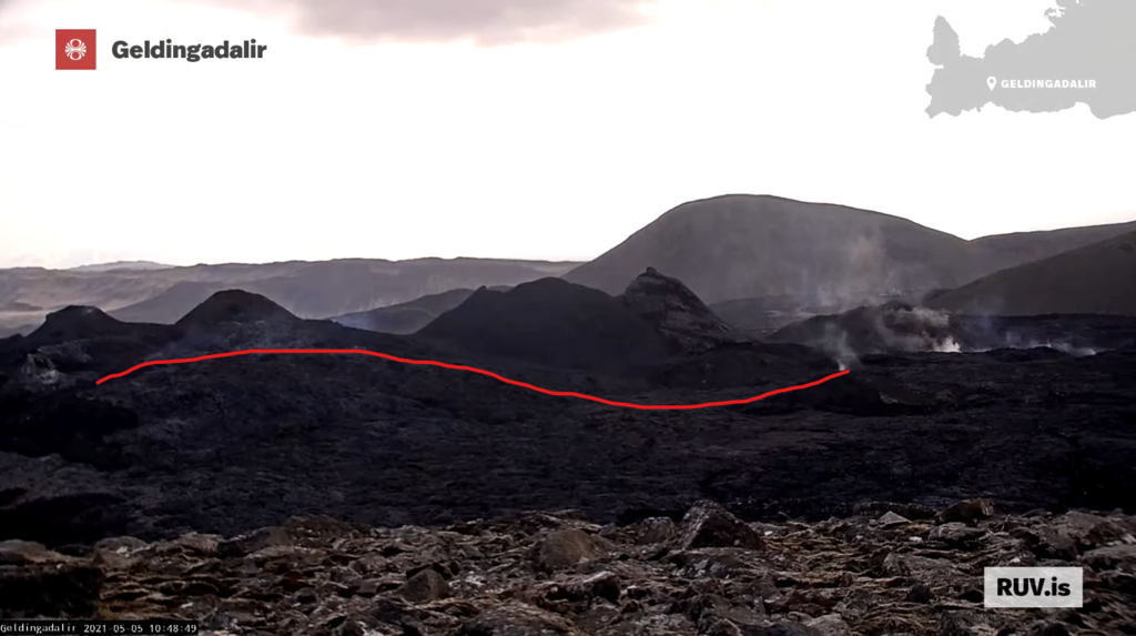
How does this compare to the fissure? An excellent Landsat shot of the series of cones (and lava flows) has just appeared, showing all 6 cones.

The series of cones follows the direction of the main dike quite well. However, the fissure is offset to the west by about 200 meters. I measured this several times but could not get the mid-line locations to match. Between the deep dike and the surface rupture, there is a slight tilt. This seems problematic: it is a principle of geology that dikes are vertical and do not tilt. Perhaps the dike is not quite at the central line of the earthquakes, the dike has a few more small but unrecognized changes of directions that bring it in line with the fissure, or the fissure is not actually the top of the dike but there is a tilted conduit between them. Most likely, of course, is that I did not get the measurements quite right.
There is one further surprise. The dike will find it easiest to erupt at the lowest point, where there is the least amount of rock to melt through. The eruption happened close to the point where the magma came up from the mantle. Meradalir would have made a good eruption point, being a deep valley, but the dike bypassed this. The next lowest point was the valley of Geldingadalir where indeed it erupted. But in this valley, there is a small hill. Strangely, it erupted near the top of this hill. The later cones similarly avoided the deepest valley and went for the higher ground to the north. This remains unexplained. For some reason, the hill was a weak spot which allowed easier access to the surface for the feeder dike. We will come back to this.
The Reykjanes fault
The Reykjanes fault was crucial to the development of the dike. This was the fault that initiated the immense swarm of earthquakes which announced the eruptive intent. It gave way in several M5 earthquakes. This fault is mostly a transform fault. The south side is moving east relative to the north. The interferogram shows the movement beautifully. Red (eastward motion) delineates the fault perfectly.

Let’s put this on the map. Here is the map of the dike and fissure, on top of the digital elevation model. The black line shows the Reykjanes fault, as traced by the area where the surface moved to the east. There are slight offsets along the line but I have ignored those. The white lines shows the region of earthquake activity along the fault in the weeks leading up to the eruption. These were largely aftershocks of the main earthquakes where the sides of the fault made small adjustments with minor failures. The dashed white line shows the location of an earlier series of earthquake which happened in 2017. The earthquakes were seen in an area north of the surface motion.

The fissure is closely related to the fault and the fault earthquake zone. The fissure terminates on the fault itself and did not cross the fault. This eruption belongs to the North American plate and did not manage to cross into the European plate. Interestingly the dike had no problem with this and happily crossed over. It seems that at depth (hotter rock) the plate boundary is easier to cross.

The circled feature is close to where the Reykjanes fault is located, and perhaps traces the surface rupture of this fault. Source: Lughduniense
The second point to note is that the length of the fissure largely coincides with the width of the fault earthquake zone. This eruption occurred where the dike crossed the fault crumple zone. It made use of the weakness of the rocks in this area.
This immediately show the importance of the Reykjanes fault. The fissure similarly began exactly at the fault line, and extended northwards from there.
That hill

The early days: the cone on the hill
When the eruption began, the first fissure followed the ridge of a small hill in the Geldingadalir. The origin of this hill was not clear. It was not a result of an earlier eruption. It may have been glacial.

Step-over faults
However, the location close to the Reykjanes fault suggests another possibility. The Reykjanes fault may have step-overs, where the fault consists of segments which are slightly offset. This is very common for faults that are young and still in the process of organizing themselves. An offset in a transform fault can cause conflicting movements. The step-over can cause either cause compression or extension in the area in between. In the first case, a pressure ridge can form a small hill form in the area of the step-over. I speculate that the hill of Geldingadalir is (was) a pressure ridge: it is the location of the transverse fault where at one time a small step-over occurred.

Pressure ridge along the San Andreas fault. https://www.flickr.com/photos/rwolf/48004993242
Pushing this speculation a little further, the transverse crumple zone may have given the magma the easier pathway to the surface for the feeder dike. This would explain why the fissure ran along, an in fact started on, the ridge of the Geldingadalir hill.
Where pressure ridges occur, you can also find sag pools, or small basins, where the fault pulls the crust apart. Was Geldingadalir itself such a depression? This is becoming even more speculative.
Extension
The Reykjanes fault is more than just a transform fault. There is also a bit of extension here, a little bit of spreading. The sides of the fault slowly pull apart. If I am allowed to speculate even further (we are getting on very thin ice here), the notably deep valley of Meradalir could be a result of this extension, as a small pull-apart basin approximately along the line of the fault.
Can I see any evidence of the movement of the fault? That is notoriously difficult. It means finding features in the landscape on either side of the fault, and matching them up. But landscapes evolve and the two sides may not look alike any more.

I can attempt this for the ridge that separates Meradalir from Geldingadalir. It continues across the fault but the appearance is quite different on either side of the Reykjanes fault. Perhaps this isn’t the same ridge? There is another ridge a bit to the southeast which looks more like it. If I shift this ridge according to the spreading direction and transform movement, the two ridges line up fairly well. The offset is some 700 meters. Assuming an average movement of 2 cm per year, this makes the ridge 35,000 years old. The offset nicely delineates Meradalir which becomes a small pull-apart basin. The ridge would have formed during the depth of the ice age.
I can push this further. On the south side of the fault, there is an eroded plateau which lies just south east of the ridge. There is no such plateau on the north side of the fault. There is however one on the west side of the area: the high plateau of Fagradalsfjall. Could that be the same plateau? In that case the offset is around 2 kilometers. The age of the plateau would be 100,000 years. Was this a shield eruption? The lack of ridges would imply there was no ice when it formed. And indeed, the time is close to the last interglacial when Iceland was ice-free.
This is deep speculation, in severe need of data, even if those data may well show it to be in error. Lots of handwaving involved! But the ages make sense. The Geldingadalir eruption came in an old landscape which had seen little or no volcanic activity for tens of thousands of years. It is a unique event. We are very lucky to have seen geology in such action in our life times. The last time this happened, we were still into cave paintings.
Albert, May 2021


https://twitter.com/EIlyinskaya/status/1389839061045719042?s=20
Who thought the intermittent fountaining was all bad? It’s allowed Sentinel to take the perfect, clearest view of the flows so far. Just gorgeous. and is that the solar panels of the camera shining back in the right hand side photo? Some sharp eyes on Twitter!
So, I was only about 40 metres out when I placed the camera on Google Earth back in March :P.
Watching RUV’s backside webcam I’m wondering about a line of smoke parallel to the old fissure line, west of it. In the screenshot below I’ve marked this smoking/steaming line in red. The glooming spot yesterday night is in that line.
Source: https://www.youtube.com/watch?v=7-RhgB1INII
regarding lavanadoes:
here you can see pieces of Lava thrown around by what I think is a tornadic wind aka lavanado, a fierce smoke devil can also be seen here: https://youtu.be/c_vnsLQBVlY?t=671
I was puzzled by the funny little hill and the odd valley it was sitting from the beginning of the eruption. The valley clearly hasn’t been created by water erosion otherwise it would have a distinct out-flow and it doesn’t.
Well, its taken me a couple of days to organise, but Albert’s image of the Reykjanes Fault through Geldingadalir got me thinking. It used to be a favourite passtime of mine to identify and trace surface features of faultlines in Google Earth. I took a look at Google’s pre-eruption satellite image of Geldingadalir and made an interesting observation:
The boundary between that funny little hill and the hill it is stuck to is suspiciously straight. In fact it looks like it lines up pretty well with the position and angle of the Reykjanes fault as drawn in Albert’s illustration. If it is a surface expression of the fault then that would support the idea that the funny little hill is a pressure ridge, and the lowest part of the valley just to its north is the corresponding sag pool.
As a further note, the surface features on the hillside to the west of the valley, on the lower rise of Fagradsfjall, look entirely erosional to me and none seem to line up with the fault line.
Great article Albert, most thought provoking, thankyou.
It is looking like intervals between fountains are getting a bit longer and the fountains are larger, very interesting. I wonder how long the eruption can pause before the lava flow is unable to sustain, the channel near the vent is deep and slow so acts as a buffer to the episodes but obviously if the eruption goes a day or more before fountaining this wont be enough. That being saud after a day the fountain ought to be pretty big, a days worth of lava in 20 min or so if scaled to current episodes. Would be quite scary if we go to monthly intervals, then we get a few hours of massive fountains and raging lava rivers.
Its also still technically a ‘slow’ eruption too, so could go on indefinitely or at least until the cone ruptures, and that itself could take years if Pu’u O’o is an adequate comparison.
I am still thing that the magma had been pulsing “all along”, but did not reach the surface until the pulse energy was no longer being dispersed laterally along the dike?
Seems logical that hot magma, rising vertically in a conduit, would scour bulbs at hose depths where a constituent part decompresses forming gasses…and pulse?
Video from the crater
https://twitter.com/BSteinbekk/status/1389886682296631299
It’s quite a visceral jolt to load a webcam and see – nothing. My head says ‘ it’s in the quiescent state’ while my guts wrench. Only when the next fountain breaches the lip does the feeling of relief flood over me… I’m so enthralled it’s getting ridiculous.
And here’s a question I’d love answering. Where do all the lavabergs come from? There have been one or two monsters progressing through the flow recently. I’m finding it really difficult to track them backwards because of the light overexposure overnight. FAlling cone chunks tend to either fall within the vent, or away from the outflow. I have only seen one or two events where smaller lava brash (name borrowed from glaciology) has been swept out of the vents into the channels, but that won’t account for the monsters I’m seeing down-channel. Are huge chunks of the channel detatching and floating away? One memorable lavaberg got stuck around the bend and changed the flow towards its current path to Meradalir. Is there anyone else intrigued, or am I a lone thinker here?
The ones I tracked formed in the lava channel itself, perhaps when part of the levee broke off.
That is plausible, the levees of a channel are often floating on top of the molten interior of a lava flow, they might break off and be carried downstream.
It’s fascinating to watch the sides collapsing and cooling lava dropping into the melting pot…then being ejected in a huge fiery fountain.
https://www.youtube.com/watch?v=I1I-0PUhFmU
Nothing much has happened to the little smoky puff, but interestingly it’s still pretty strong and isn’t apparently cooling quickly. or moving along like lava should!
1/2 There was a slight change in the seismic tremor measurements at #Fagradalsfjall shortly before 4:30 am. Rhythm had been the same until then, approx. 10 min between magma jets. But this morning about half an hour passed between powerful magma jets. #eruption #Reykjanes
2/2 At 5:40 am there was an unusually high magma jet that went beyond the current perspective on the RÚV webcam, seems to have risen above 460 m. #eruption #Reykjanes
https://twitter.com/Vedurstofan/status/1389881719692701701?s=20
Here’s that fountain at about 05:39 this morning
Holy 😮
Image from IMO tweet
What do the blue numbers stand for? That seems to be height above sea level, not above the ground, if in meters then the fountain is a little over 200 meters at its tallest. Less than half the height of Kilauea Iki or Pu’u’o’o. It is also a small fraction compared to the heights reached by Etna or Vesuvius, claimed to send fountains to a height of 2 kilometres, although it is not easy to measure the top of such fountains that usually contain a lot of incandescent pumice floating up into a plume.
The tall hill in the background is just 100 meters higher than the eruption ground when measured in Google Earth. A 300 meter high fountain would be already pushing it. It is impressive nonetheless for such low eruption rates, the high CO2 content inherited from its deep origin in the mantle must be boosting the heights.
No wait, I was looking from the wrong side. I have seen where the Geldingadalir webcam is positioned and the highest hill in the background is 50 meters taller than the eruption site. The blue numbers seem to represent the height above sea level, in meters of the topography in the background that is delineated in blue.
Each fountain lasts for only a few seconds too, but the eruption pauses for minutes beforehand. 7.5 m3 is the average effusion rate but it probably goes way up into the hundreds of m3/s in the time the fountain is active.
The lava cataracts into Alae crater, which you probably know of, were a rate of 400 m3/s. Imagine if the flow of those cataracts was concentrated through the breach of the Ragnar vent. It would be as if the whole side of the cone was a fiery flood gushing at full speed, which isn’t the case. It is just a small river even at the fountaining apex. So I doubt it gets much higher than the average.
Fountain height or column height might seem like reasonable approximations to the eruption rate of eruptions at first, but in reality they aren’t.
The best way at the moment to judge output variations is from the lava stream visible on http://brunnur.vedur.is/myndir/webcam/2021/05/05/webcam_langihryggurN.html There may be a bit more pulsing in the stream, so that the output does vary with the cone activity. But overall it hasn’t changed much, I think
Doesn’t count – much falls back into the crater! Unless you allow for a negative effusion rate 10 seconds later when it comes down again.. it is an extreme case of lava lake turbulence. Very impressive though. Who would have thought a year ago Reykjanes could do this? (Actually, we did – we predicted a high geyser from the blue lagoon last year! Does that count?)
Holy cow! That’s quite the lava fountain! This must be at least 300-400+ m (984-1312 ft) high. At the upper estimate, that’s even taller than in Kilauea Iki’s 1959 eruption, which was up to over 320 m (1050 ft).
Laki was twice the height, ” I say in a matter of fact fashion, deliberately tempting fate” LOL
I like records being broken.
Is this now the tallest fissure fountain ever filmed on a live stream?
I realise other fountains like Etna’s are higher, but we are talking fissures here not other stuff…
Not quite, most if the Laki fountains were in the range of 350-500 meters or less, in two places it reached 700 meters but that was in the early part of the eruption. The fabled 1400 meter fountain was probably either phreatomagmatic or a misidentification of a glowing eruption column, im more inclined to go with the first option at least to describe the initial vebt opening. Maybe best way to visualise Laki was basically that each fissure behaved just like Holuhraun except that new fissures opened every other week when the last one stopped fountaining. There was no 23 km long curtain of fire mega lava flood though, maybe only 1-2 km long individual fissures that opened episodically to the northeast, it was maybe not too different to Kilaueas eruption in the week or so before it settled at fissure 8, just a lot bigger in scale and way longer.
600 meters for Kilaūea Iki glowing parts .. and black tephra 1 km tall during the jetting phases
There’s the one to go for then!
3 days away?
Great stuff.
It was 460m…
Nice fountaining. I not looking so much now at webcams. Reading most.. And now when i did they put camera up side down for a while. get almost dizzy 🙂 And no…it did not run out more lava do like that 😛 No good they do little checking on cameras.
De fountain reached 460m above sealevel accoding to the mbl site
https://twitter.com/BensVolcanology/status/1389981180741697549
LOL!
LOL
Brilliant!
The world needs more creative thinkers like this.
It always looked like a chamaeleon to me!
It looks like godzilla on a moped to me.
Per USGS, “On December 17, episode 15 produced lava fountains that were approximately 580 m (1,900 ft) high, the highest recorded in Hawaii during the 20th century.”
https://www.usgs.gov/volcanoes/kilauea/1959-kilauea-iki-eruption
Some comments cribbed from the Viðburðastofa Vestfjarða FLOcam webstream about the maintenance (a huge amount of complementary comments deleted for clarity):
JUIN DUTTA: thanks camera crew. let technical and the tectonics collaborate for some time.
Val Cano: RUV cam is up with a nice view
Ididntdoit: the hamsters need daily attention. a little petting, ear and belly scratches, some hamster kibble, you know, just some luvin’
Rhythm Round: Check out 16:12:40. What is his message with the three points?
Rhythm Round: He pointed to Nar, then to Bob, then to the left of Bob
Imocchidoro: Isn’t this camera on the hill surrounded by lava?
Charles Gregory: @imocchidoro Yes. it is. That tech probably came in by helicopter…
HREINN BECK: We are finishing up some things – it’ll be back on soon
Paul A: seems @hreinn beck is the tech guy and it will be back soon
Val Canois: the tech guy seen in the lower right of RUV Cam?
Kev Holmes: MBL camera guy still onsite (Visible on RUV Langihryggur cam)
HREINN BECK: @Paul A I’m sitting in the sofa at home, but one our techs in on-site. Just changing out some networking equipment and batteries and it will be back on.
Paul A: @Hreinn Beck thanks hreinn for the update
Iqbal: @ stradford the tech guy, tried to make it better
musak maker: @Hreinn Beck thanks for working on the camera and thanks to your tech(s) out there doing it, much appreciated 🙂
Anonymous Pi @iC Zero tech on site, scroll back for adjusted view before ‘maintenance’ things 🙂
HREINN BECK: it’s back in 30sec
Russell S: @Hreinn Beck all of you working to provide the live streams are the best, thank you!
Paul A: 1300 people are currently watching a blank screen…
iC Zero: Saw the guy messing with it but then had to make some calls
ship dog@Hreinn Beck thanks for keeping us updated
jaxtraw: I wish I could stand where he is standing
musak maker: @Hreinn Beck we hope you didn’t ask your guy to go stand by the crater to give everyone a sense of scale 😉
HREINN BECK: @musak maker Naah he’s just acting like a tourist
ship dog: I hope the technician is ok
HREINN BECK: @ship dog He’s fine. Going to work on other cameras on the gill.
Rhythm Round: Thanks for coming here to talk to us, @Hreinn Beck!
HREINN BECK: There are tonne of variables that need to be considered when running cameras like this. Primarily it needs to be useful for scientist and SAR. For that purpose we don’t like to make many changes.
HREINN BECK: Fixed frames and exposure etc. are important for comparison over time etc.
HREINN BECK: If anyone wants to wire me $15K I’ll put up a camera with exactly the view they want. Running cost is about $2k pr. month for bandwidth and maintenance.
Paul A: @Hreinn Beck wow, didn’t know it cost that much
Kev Holmes: @Hreinn Beck – that $2K pm include onsite maintenance too? Bargain, if so! 😉
HREINN BECK: @Paul A Even more expensive now with having to take a chopper in. Though the tech today didn’t take one, he walked over the oldest lava field with a heat-camera.
helene bemis: gosh @Hreinn Beck, you and your crew stay safe
ship dog: wow walking on a relatively fresh lava flow must be terrifying
HREINN BECK: @helene bemis We’ve been doing crazy stuff like this together for about 15 years!
Jaxtraw: @Hreinn Beck Seriously, the work of you guys is so appreciated, thank you so much for this experience!
HREINN BECK: I need to get working on the other cams on the hill – I might drop by again later. Thanks for all the compliments.
Just skip this freaking youtube!
Interesting comments, especially this one:
HREINN BECK: @Paul A Even more expensive now with having to take a chopper in. Though the tech today didn’t take one, he walked over the oldest lava field with a heat-camera.
The tremor plot at the faf station is still increasing. Other stations either don’t show it or has it decreasing, with the exception of iss, where it is varying, possibly cyclically, but it is too early to be sure on the last point.
mer is also showing some increase. I’m assuming that’s Meradalir although they don’t say on the site.
http://hraun.vedur.is/ja/oroi/allarsort.html
I didn’t spot that one. It actually looks like more stations have been installed since the map on Twitter. Afstapahraun (ash) is another one nearby and scanning through, I suspect there are others. I’ve been using the index page to avoid scrolling through.
You can tell which stations are in the area because they all show that same tremor pattern.
Yep. Some slightly further away (Vogar, von) are also showing fluctuations, particularly since the obvious pulsing.
Von’s fluctuations are different. It is shaky from midnight to early morning, quiet the rest of the time. that doesn’t feel volcanic
Von is Vonarskarð. That’s a Bárðarbunga station. Vogar is vog. I think the daily variations of von is probably due to temperature fluctuations.
Especially these days, thanks to that south-going plume shown in that satellite photo.
Peaking at the wrong hours of the day to be human activity. But those are the coldest hours of the day. Icequakes induced by thermal contraction?
Yes, looks like icequakes to my amateurish eyes.
Thanks everyone, I realised after I posted, that I’d mixed up von and vos (which isn’t showing any fluctuations).
I can understand the fluctuations of some stations during the day (traffic etc), but what about the fluctuations at Vogar (vog)? The only thing I can think of is something to do with the nearby factory, in terms of manmade, but I don’t know anything about the operations within it and whether they would be more active around the hours of midnight. They probably peak around 6.00-7.00 am, but start rising around 10.00pm. Tides are the only other thought, as it is on the coast, but then I would expect two peaks.
The VON pattern can also be seen on JOK but not on the other Vatnajokull stations.
https://twitter.com/simoncarn/status/1389981891130974211
This is nearly three weeks old, but I think the pictures are beautiful enough to be shared. I’m not so sure though whether you people like this here, it’s not geology, but photography. I think he’s good.
https://petapixel.com/2021/04/16/stunning-documentary-shows-the-birth-of-a-volcano-in-iceland/
Thanks they are awesome pic!
I really like the dike pic.Sheet of paper, like Albert said.
One can see on RUV camera or RagCam that Flo seems to be alive again, some spattering 5 minutes ago!!!!
https://youtu.be/BA-9QzIcr3c
From 21:45:00 and on…
That is so weird. It’s almost like someone is blowing soap bubbles.
All I can see so far is small puffs of steam/gas… No one is talking about another vent reactivating.
Nope. The flow will continue to increase, as the hell machine ramps up. The lava lake will continue to rise and envelop the cones. The fountain heights will begin to recede, as the pulse energy is dissipated laterally into the lava lake. The cones will be absorbed into the lava lake and then….a SHIELD IS BORN!!!
Great-grandchild of Tamu Massif, Shatsky Rise? The future Shatsky Rise of the Atlantic?
So, one day, when it is eroded (a bit earlier than the Atlantic’s Shatsky), it would look like Fagradalsfjall in Albert’s grey models in the piece looks now. That would fit quite well.And that it’s all supposed to be on the American plate makes sense.
The media nowadays and most of their readers love death. 15.000 after the Tohoku earthquake is the biggest news and the new standard afterwards . This is the opposite as this is creation. I love this.The media is from Hades.
It’s a bit stronger this morning. Wisps of white smoke/vog/whatever occasionally appearing at the top edge of the black cone. The camera is so far away, it’s impossible to see what is really happening.
Sharp eyes, Esteve.
A fantastic moment:
https://m.youtube.com/watch?v=K8q-9OXKkF0
Meradalir from the 3D model of 3/5/2021, since we don’t have ecoveage down there. And it’s goodnight from me.
Goodnight!
Just a note on the daily fluctuations seen on the tremor graphs from the IMO
Fluctuations at stations on icecaps is due to temperature. We are heading into Summer so there will be Ice melt. Water courses will swell and there will be ice falls within the glacier. More in daytime as temperature rises.
Human activity is very noticeable. Especially near fishing ports such as Vestmannaeyjar. Here you can clearly see when the fishing boats go out in the morning and in during the afternoon. There aren’t enough cars to create a road rush hour as would be seen at Stations nearer larger towns.
Daily regular fluctuations are absolutely nothing to do with the Moon, aliens or subversive activity!
Activity under glaciers happens more in late evening and early night with the daily Ice melt coming into effect.
Places such as Haukadalur (Hau) will be busiest with tourist activity during Mid day to afternoon.
Those stations very near the coast will show movement caused by waves so check if there is a storm happening, even wind can cause tremor. Volcanic activity is more constant if the eruption is happening . Weird, unexplainable and very obvious peaks and troughs are more likely to indicate something going on underground if you have checked all other possible causes. This is just a very basic help for Newbies. Those tremor graphs are good indicators but can be difficult to interpret. The best thing to do is to ask the more expert watchers. There are no stupid questions. Every expert was a beginner once.
Quiet right-there are no stupid questions-after all -all things volcanic are complex and ever changing.Takes years to get one’s head around it! All questions are good if you don’t know the answer!
Dug out an old VC post about plots.
https://volcanocafe.wordpress.com/2013/05/09/how-to-read-the-icelandic-borehole-strain-and-seismicity-plots/
I was looking for another usefull post about the subject. When I find it I’ll post a link.
Henriks article I was looking for!
Good read!
https://www.volcanocafe.org/interpreting-the-imo-tremor-charts/
Great. Thank you.
A timelapse from both mbl cameras simultaneous (except the beginning) from last night
https://youtu.be/eEXXaSaM9us
The regularity of the outbursts is strikingly evident when you speed it up like that. It’s almost like the Earth is breathing, in, out, in, out.
I was concentrating on the lava channel, some lavabergs were carried in the flow but others seemed to form mid channel, causing some back-up and small overspills. The channels do seem to have no trouble containing the lava so that the intermittent pausing of the lava feed isn’t reflected down stream; there’s no cyclicity to the levels in the channels, like previously when the channels would drain catastrophically.
I’ve been keeping an eye on the height of the fissure 5 cone over the last week or so, comparing it to the height of Tech Hill behind it (as seen from the RUV Geldingadalir camera). It is slowly growing taller, and it has reached an impressive size, though still small compared to some of its Hawaiian cousins.
It looks like the eruptive vent has moved slightly northwards to where vent 5B used to be, before it got swallowed up by the main 5 vent, or perhaps that’s just due to the cone growing significantly wider on the southern side due to the fountain fallout.
At least the cone and I have one thing in common: Lateral growth… An unfortunate occupational hazard in my profession.
You can also grab the very highest reflective values from band 12 (short-wave infrared around the 2190 nm wavelength) and see the thermal signal from the exposed lava streams as well as some small signals on the Geldingadalir south front that is very much active.
https://twitter.com/RagnarHeidar/status/1390060947952263172
“on the Geldingadalir south front that is very much active.” Too bad none of the cameras point that way. No way of seeing what those small heat sources might be. Could they be man-made? Hot dog stands?
Moss fires
Did you know that 75% to 90% of volcanic gas is superheated steam which is invisible but can catch moss afire easily?
Its only superheated at the vent, it will cool fast in the open air. Probably nearly all the smoke at the vents is this effect of steam condensing, as there seems to be no fine tephra at all.
I did say in an older comment but the eruption has been going on a while now and the heat will have spread through conduction, same thing on a way bigger scale is still happening above the 2018 dike at Kilauea. There probably is some magma intrusion too but its not required to produce these effects.
That’s an active front of the lava field. You can see in the other image how the lava lobe has grown since the last image. It’s nothing spectacular, only a slow expansion. It’s to be expected since lava is still flowing into what used to be Geldingadalir.
I was looking at photographs with my daughter. Theo Bosboom, a Dutch photographer, has been there and has a very special picture of people with headlights coming down at night looking like a river and cone in the background:
https://www.instagram.com/theobosboom/?hl=de
Currently fifth pic, don’t own account, easy to find.
And a timelapse from the RUV Fagradalsfjall view , yesterday afternoon to this morning
https://youtu.be/uxGerseeYzg
Has anyone discussed the smoking fissure to the NW of the active cone? See https://drive.google.com/file/d/1C6AmClPgjU6Ox4tS3m9OEjDciPw3dBWP/view?usp=sharing which I took at 14:57:13 UTC
I am curious as to what is going on here?
That is moss fire.
Thank you, I will accept that explanation.
at 19:29 UTC, that fire has significantly increased and 2 new ones have broken out.
i think we might have a third option. Yes, it’s a moss fire but i think it could also have a chimney component to a lower level brining up some gasses from below. It’s pretty stable so that’s my think. and i’m thinking it. 😉
I agree with you, mots, that some time of gasses are leaking up. When you see long fissure lines of steam and smoke, you have to think some type of hot volcanic gas release. I have been trying to argue that this interpretation of events needs to be carefully checked out as the possible explanation as to what we see here.
If it is the upwelling of very hot gas which combusts the moss, then we need to be aware of this and take appropriate precautions.
It is important to realize that fissure eruptions will follow their own rules, not our theories.
One more thing, if we could get a good FLIR infra-red camera, like the USGS uses, this would go a long way to answer this hot gas emissions issue, perhaps giving us conclusive evidence in the first photo to finally settle the question.
well even if any question gets settled it may not continue unchanged… one thing i’ve learned from life…………………………. EVERYTHING changes. ((and that’s a good thing.)
)
I just learned that 75% to 90% of volcanic gas is superheated steam which is invisible until it cools down and what do we see? Lots of steam which no one can account for. The day of the big steam we had the active conecwater hammering with those big gushes which require lots of high pressure. I hope someone gets this now
” that’s my think. and i’m thinking it.”
Satisfying the first rule of a think. It has to be thought first.
Haven’t seen this posted about yet, there is a new stills webcam for Meradalir:
http://brunnur.vedur.is/myndir/webcam/2021/05/06/webcam_meradalahnukurSV.html
In fact there are a few:
http://brunnur.vedur.is/myndir/listi/
Check out the thumbnails down the page – newest ones at the beginning.
Well two out of four are working, but it is one hell of a view.
Very useful! Thank you!
Thanks. Some of these Meradalir stills (afternoon!) are exceptional!
They are. I’ve been expecting at least one of these cams to be set up for a while, so have been checking daily. Not had a chance today until this evening. Worth the wait I reckon.
There is actually only the two views – South West and South South West – the other two in the thumbnails are duplicates.
Nice overview of the eruption site. If the lava ever reaches Natthagi, the Slaga NNE camera will also be useful.
I’m having trouble wiith these links. The photos are 4x the size of my screen, and if I reduce the size, I cannot read the time links on the right It’s a lottery and makes no sense at all. I try to magnify just the text, having reduced the whole thing, but the photo goes back to full size. Then when I go to the other Gervitunglamyndir webcams, the photo links are reduced there too!
I accessed the original 3 cameras from the ACME page, but these new ones aren’t on there.
Oh well. I’ll see if it’s sorted out tomorrow.
I do take it that nowt much has changed today…
Try using this link, then choose the desired month and day
http://brunnur.vedur.is/myndir/webcam/2021/
I just discovered that if you mouse-wheel over the image, it scrolls back and forth in time. Great to see the motion of the flows.
My little pet Fumarole that I commented on a day or so ago is still fuming. (just right of the main vent) It hasn’t changed much, if anything a little larger and still emitting very white fumes/smoke. It’s position is static and has been for the last few days. I go with the idea it may be giving off gases from deeper down. It’s shape and emissions do not change visually when the vent is fountaining or quiet. There must be other fumaroles like this.
In the Volcano Solfatara , Italy there are fumaroles that when a lighted paper is wafted over then suddenly many other fumaroles start smoking. Could this be similar and are there others along the line of the dyke/fissures? I include a clip from YouTube showing this at Solfatara. Gases burning underground? I am not sure of what the “mechanism” is . Why do other fumaroles become more active ? Is there anyone out there that can explain what happens? Trust me when I went to Solfatara in the 1960s this was pretty dramatic and very stinky! What one is walking on what is the crater crust/floor , the heat and dull thuds from the magma beneath is very unnerving
!https://www.youtube.com/watch?v=O7qGR6cVbgU
Is there a nice description of the details of what’s erupting now and expected effects somewhere ? We used to see a map showing a valley and estimates of when it would fill. I realize a lot has changed and it’s fluid but where’s the current overview/status? Is there somewhere in ith that info that’s recent? Maybe there is…
that was unnerving! esp when he pulled people thu the fumes…. Yikes! not safe at all!
Lol Mots as far as I can see, since the 1960s where there were few safety measures there, the only things that are different are more warning signs and barriers and the camp site that was in the Caldera has gone as it was deemed “Unsafe”. Ultimately it is up to the individuals to use common sense as we did when we decided driving tent pegs into the crust of an active caldera was not a good idea and didn’t bode well for a relaxing night’s sleep! Tourists that visit get up close and personal to active volcanoes anywhere in the world should be made aware of the risks involved. Sadly, money & a selfie on the iPhone speak
louder than common sense at times. (see all disaster movies from Hollywood!)
Nice physics and an experiment that always goes down well with students. Overpressurise a glass container with a little water at the bottom. Release the pressure and the container will cool down. So fog should form in the container as water condenses. But it doesn’t. Now do the same experiment but before priming the container, light a match and put it in the container. Let it go out and now repeat the experiment. The container fogs up instantly. The difference is purely the smoke from the match. Water does not just condense when temperature drops, it needs something to condense on to. The match provides small smoke particles and they do the trick.
Here’s another take on why there is regular, long-period (intermittent) fountaining from vent #5:
https://www.youtube.com/watch?v=I4-uYI9XX_g
Is this a kind of pistoning writ large?
This is the same hypothesis that I have pushed for almost a week now. The main difference is that the video had nice graphics showing it. I however believe that it is the dyke to the one or several of the other vents that is the chamber that causes this effect (as this effect started when the older vents stopped smoking). This is possible if the currently erupting cone plumbing lies lower than another cone/vent that on the other hand is closer to the actual lava source from below. If this other vent got plugged by cooling lava, then it can be filled from below with expanding gases and as the pressure increases due to more and more gases, when finally the outlet of that chamber/cone starts to let gas flow towards the erupting cone (via the plumbing to that cone) gases will expand further causing a rush that ends up as these fountains. The pressure gets lower when the gases are released and then the fountain stops and the chamber starts to fill with gases again until these starts to leak into the active cone again, and then we have another fountain event.
I just learned today that the most common volcanic gas is H2O or superheated steam, and it can be 75% to 90% of that total amount. The next gas is CO2 then SO2 and down the line.
I have watched fumeroles pop up all over the place and they are emitting steam. I also have watched rows or lines of steaming and steaming increasing instead of decreasing if combustible material (moss) were causing it.
Furthermore everyone on this website knows that the active cone has been geysering and that takes pressure, lots of it.
So my opinion is that what we are seeing is the release of superheated steam and it has ignited the moss afire.
No, loose matches tossed by careless Icelanders is not the cause, nor barbeques tippnig over due to sudden wind gust, nor pyroxene gas which seems to display superintelligent behavior in selectively lighting linear strips afire as it selectively hits only certain places and ignores others or overheated spots due to infra-red radiation caused by big magnifying glasses focused on the active cone…. nope, I don’t accept these explanations anymore.
So that’s where I am at now… superheated steam from underground fissures which has been squeezed from yellow hot magmatic dikes lurking not too far away is the best scientific explanation for all of this.
And that’s where I have come, after carefully thinking 3 weeks about all this..
And it all got started when I saw gas flareups, the night the 3rd fissure opened up.
And one more thing which I forget to mention…
Do you think that those steaming vents at the end of the fissure, when they first appear, at either end is trying to tell us something IMPORTANT and we just didn’t get the message?
Randall & JanB I think you are both absolutely right. Somewhere down there the magma is being squeezed and pressured. This whole behaviour is being seen in action whereas up to now geologists have only been able to hypothesise about ancient eruptions and the subsequent topographical formations. HOW the eruptions looked as they happened is guess work. This is why this eruption is so important. The behaviours give clues to the structures beneath. We watch and learn. The dynamics of a good old straightforward eruption from a magma chamber + some water are understood pretty well and the behaviour can be reasonably predicted. Here on the Reykjanes Peninsula we have rifting, ancient dykes, pressure ridges and who knows what being thrown into the turmoil below. Every little observation or even non-observation is worth commenting on no matter how seemingly unimportant. We are all making a small contribution to records and observations that can be used by volcanologists in the future. Historians now use the diaries of simple folk to build a more accurate picture of how things were. Scientists are realising the importance of ordinary people reporting their own daily Covid experiences so they can use all that data to make us safe. So please keep observing and commenting. It all helps to a greater understanding and so ultimately accurate predictions that will save lives.
The moss fires were caused by tephra being ejected that far, it was posted a while back with pictures of the material that ignited the fires. It was not caused by magma or steam underground
I partially agree, and I was surprised to see the tephra fragment thrown so far, but yes, it started a fire. I am glad to see that people are starting to address this. GutnTag I believe, posted on this. Good for him!
But that does NOT account for everything that we see. Again, when I sit and watch something for 2 hours, and 3 new fumaroles pop up on a line which I have laid out, that confirms a hypothesis and fulfills the prediction of that hypotheses.
This is a brand new type of eruption we’ve not seen in 781 years and it has a different set of rules it is playing by, including that unusual geyser action of the active cone.
“This is why this eruption is so important. The behaviours give clues to the structures beneath.” True. Quite unique. Nice post, encouraging too. When I see this happening I imagine LIP and wonder whether this will become a LIP in the next one million years. If this is wrong you correct me, please. If it is right It wouldn’t have taken the dinosaurs down unless there was some highly poisonous gas involved.
removed on request by commenter. it was reposted with typos fixed -admin
Dear moderator, please replace the comment before with this one with corrections if possible. Four writing mistakes is too much. Thank you.
I’ll explain this a little further. Those now extinct LIP esp.the Deccan traps or also Kerguelen might have been just like Hawaii and Iceland. So, in case they developped in a similar way it would have been a slow process over 1 or rather several million years. Spreading ridge and plume involved, just like Reykjanes, here question mark concerning the plume.
As people (unless they tend to selfie sensationalism) have enough time to go away or, in the case of dinosaurs also swim away to Antarctica i.e. which was further North then and semi-tropical they wouldn’t go down.
They go down with a St.Helens-like eruption or a Pelean eruption, those who had no time to flee. In Martinique, many animals are said to have left the mountain, but then they died further down, also in the town. But lava flows seem to give enough time although they can be faster with steep terrain. So, I am getting to the conclusion seeing this process over there, developping very slowly, about six weeks now or more, that the extinction of all Dinosaurs caused by the Deccan Trap flood basalt, an idea of Gerta Keller from Princeton, might be wrong. Watching this. Watching the time it takes and also the room it leaves in between lava flows. And I’ll settle more for the impact.
I mean those beasts didn’t make selfies. They pack and move when the earth quakes start. Same in the Andaman and Nicobar islands before the tsunami was there.
Therefore this eruption being so closely monitored should give paleontologists something to think about concerning the Deccan Trap theory. Some might have perished when India was still lingering over the Reunion hotspot. But that must have been much earlier, around 90-100 Ma, and the Indian plate is said to have travelled fast.
So, I go for space. Jupiter did’t pay attention 😉
Deccan traps was 66-64 million years ago, not 100. The scale of these provinces is also way beyond volcanism even in Iceland or Hawaii, its like all of Iceland being active at the same time, even if maybe similar in intensity the scale is far bigger.
But the consensus is that the asteroid was the real killer, volcanism is not fast enough to be so total, if one loosk at the P-T extinction it was a bigger hit but also took a long time with several waves, and a lot of surprisingly big animals survived. K-Pg the only animals that survived on land were under 20 kg, and basically every surface dwelling animals of every sort full stop was wiped out, not just non avian dinosaurs but also birds, mammals, crocodiles, lizards, they all got wiped out on land… The only reason these groups survived was due to aquatic habits and also probably that these animals lived far from the impact. All birds today evolved out of only a few species at the K-Pg, thought to have all been generalist omnivores or herbivores that lived in a semiaquatic setting, like ducks.
P-T is the one that scares me, because we might be heading toward causing the same thing to happen again. CO2, massive warming, C3 photosynthesis fails, most land plants die out, and there goes the food chain on land, while ocean acidification reaches a severity sufficient to do for the bulk of the sea life. Enough of the plants and algae died that there’s evidence of O2 depletion toward the end, taking it low enough to suffocate most remaining animal life. And this happened not once but several times in a row after major flareups of the Siberian Traps and accompanying CO2 pulses. Not a lot was left after that.
Thank you, Chad. I know that, but that must have been without the Reunion Plume, if it is correct that India and Madagascar separated between 88-100 Ma. It’s two different dates for the separation of the plate and the Deccan traps.
Just suggesting Reykjanes plus time (many million years and Deccan not happening in one day. Well, maybe not.
Twisted One, PT more dangerous, agreed.
P-T took a long time though, just that from so far in the future that we are today it seems like a brief event. In reality it would have been a gradual decline, individual animals would have had hard conditions but it was not the apocalypse the dinosaurs saw or is portrayed by the media, it was a ong imperceptible decline, one that took a million years to finish totally.
The asteroid was the main killer in the K-Pg, which by the most recent study wiped out everything on land in a single generation. Deccan Traps would have caused a similar effect to P-T, an extinction but a gradual one that was long enough that a lot of non-avian dinosaurs would have survived, and the Cenozoic would have been still dominated by them.
I agree, Chad. The difficulties are from other sources. Look: Geologists, specialized on plate tectonics, make the split between India and Madagascar 90-100 my old. Paleontologists and Volcanologists make the Deccan Traps 65 my old. These dates just don’t match. I twisted my head with those numbers numerous times.
Proposal: Africa was further to the West and to the South then, together with Arabia still connected. So, is it worth pondering whether India did not pass the Rèunion hotspot, but instead split off further North over the hotspot that belongs to the Afar triangle? This would also mean that the speeding theory would collapse, India just quickly divorcing from Africa and then Australia, then speeding across the part of Tethys that later became the Indian ocean.
If India was sitting on the Afar hotspot it would change everything about the dinosaurs as the Afar hotspot might have been sitting on the Equator back then. This would mean a nice world climate-changing super-volcano. Climate changing everywhere and for a long time.
I think the published dates on the rifting between Madagascar and India are from 85 to 66 million years ago. it happened in two phases, both with volcanic activity. The Deccan traps coincided with the final separation.
And just in case the Afar hotspot didn’t go that far down, I mean the plume, there is a nice second hotspot there in the African rift zone under those Uganda-Congo volcanoes.Just a nice little theory. And only because the dates do not match.
My comment actually was more a reply to Twisted One regarding the P-T extinction. Still, there is no debate about the origin of the Deccan Traps being from Reunion. The hotspot trail lines up, and the lava chemistry is the same origin in the deep mantle.
Thank you Albert, thank you, Cad. That’s precise data.Bye, little theory. Have a nice weekend, both of you.
Scientific consensus is littered with failed theories. Keep on theorising and thinking and asking questions. I thoroughly enjoyed this side discussion.
Lol Mots as far as I can see, since the 1960s where there were few safety measures there, the only things that are different are more warning signs and barriers and the camp site that was in the Caldera has gone as it was deemed “Unsafe”. Ultimately it is up to the individuals to use common sense as we did when we decided driving tent pegs into the crust of an active caldera was not a good idea and didn’t bode well for a relaxing night’s sleep! Tourists that visit get up close and personal to active volcanoes anywhere in the world should be made aware of the risks involved. Sadly, money & a selfie on the iPhone speak
louder than common sense at times. (see all disaster movies from Hollywood!)
Sorry about repeat Post @ Albert. I have forgotten how to remove a post! Can you do this for me please.
Some things are worth saying more than once. “a selfie on the iPhone speaks louder than common sense”
Am wondering why the active vent walls are so far apart? Is it because the actual fissure vent hole where it opens up is also wide as well? Cheers
I haven’t properly checked to quantify, but these pulsating fountains have both depositional and erosional effects; the spatter force and cumulative heating is wearing down the insides, while the same stuff is adding to the ramparts when it falls outside. If the fountains remain powerful enough, the ramparts look to be slowly migrating outwards. Unless all that heat produces another slow flank collapse (somewhere someone gave a lavatastic proper name for that, but I can’t remember where or what the name was), and the cone will rebuild itself.
My gut feeling is the fountaining focus has been migrating to where its ‘twin’ was, the defunct 5n(?) vent. The old taller southern flank seems slightly further away from the focus. At 02.48am this morning the cornice overhang finally gives way and crumbles under its own weight during a quiet phase. As I’m watching through it will be useful to see if the cornice builds up again.
A thought – are there any computer models for cone formation knocking about anywhere? That could be a fun game.
The higher the fountain the wider the crater it makes. It has to do with the distance reached by fallout and the erosion of the walls, as explained by Stars Die.
https://imgur.com/a/DvC8ZYc
This is more or less the dimensions of the eruption as it stands now. The fissure line is a bit over 800 meters long measured in google earth, and by my measurements the tallest fountains are going to a height of between 250 and 300 meters above the vent or about the same as a third of the length of the fissure. The 460 meters reported is probably taking the height of the fountain above sea level, but the fountains are still massive, hundreds of meters tall.
This picture is a screenshot from https://www.youtube.com/watch?v=I2dO294_BNY
Storihrutur is basically at a right angle to the fissures so the line of cones it is more or less in plane view, one can see how huge the active cone is compared to all the other ones, its about 80-90 meters tall.
I do like GutnTogs videos 🙂
i thought i’d asked a question but i guess it didn’t go through…
Why is the latest fallout from the vent whiter?
Anyone? Anyone?
Sorry I can’t answer that,but strange enough when looking via one of the cams I notice some of the quieter or sliight cones have a whitish coating in patches,have no idea why?
‘silent cones -should read.
The white stuff on older cones is probably minerals that condense out of the gas plume, it has been documented at a lot of places that this happens around magmatic fumaroles.
The light colour of the dust is probably because of the way it is illuminated by the sun.
OK- thanks for that,I’ll take that as answed!
A bit like the white crystallisation around the bottoms of plant pots in my greenhouse, I guess.
After this eruption is over hopefully we can find out what has crystallised and why.
Like this one at Landmannalaugar:
https://flic.kr/p/5kKacf
Could it be monoclinic sulfur condensing from the vapors still being emitted from the slight cones? sulfer has a low melting temperature, just above boiling water, and it looks whitish when the crystals are very small.
I do know that the Iceland Geldingadalir lava has an extraordinary amount of sulfur in it, and I saw burning sulfur balls tossed out from several of the cones when they were active.
Very fine sulfides – pyrite or pyrrhotite can oxidize very quickly to sulphates. Very fine olivine can alter to form magnesite – a bit slower but both oxidation products are white-ish. Can also have to do with the grain size of the solidified lava.
I seem to remember the Iceland Met Office warning people that the eruption was producing a lot of fine hairs (similar to Pele’s Hairs I guess) that were pale yellow and fragmented easily to dust and that these covered the ground away from the lava flow. They implied a respiratory health hazard.
Just the one reference so may be wrong.
https://www.youtube.com/watch?v=I1I-0PUhFmU
Good webcam… and lava seems to become more and more fluid
lavas viscosity have gone down alot… perhaps its hotter and even more primtive now
Likley less crystals…making it easier to form.. smooth lava channels
Is the eruption at Geldingadalir dying down now?
Do we have a recent estimate of the eruption rate? This would help answer the question.
No
Eruption rate now is 50% higher than it was when it began, if anything the eruption is getting stronger…
No. The eruption rate has not been measured since a week ago. i expect it has remained constant based on the flows, but the current rate is not known
I read some says… increased eruption rates…but perhaps I read it wrong
The lava seems much more fluid now on the webcam https://www.youtube.com/watch?v=I1I-0PUhFmU
It has increased, back in March the flow rate was 4-5 m3/s, now it is 7 m3/s. At the very least it has not decreased or showed signs of stoppign soon which is what was asked.
I asked this because the volcano is doing so erratically now with its intermittent eruptions. At https://icelandmonitor.mbl.is/news/nature_and_travel/2021/05/03/could_end_of_eruption_be_near/ “Could End of Eruption Be Near?”:
“The volcanic activity by Fagradasfjall mountain, Southwest Iceland, suddenly changed shortly before midnight Saturday from being continuous to becoming pulsating. “Sometimes when such activity emerges, it is a sign the end of an eruption is near, but we haven’t experienced this during effusive eruptions before,” Páll Einarsson, geophysicist and professor emeritus, tells Morgunblaðið”
https://postimg.cc/5XYDjH3X
Notice these two original cones Smeagol and Gollum to the right, which are extinct now.
Not dying… increasing as Chad says…
Magma supply have increased alot to the eruption site .. IMO geologists suggest.
The vent is now an open lava lake.. bubbling conduit… but.. it have NO deep circulation yet.
Magmatic water vapour drive the fountains
Rustynailer- Like the ‘the greenhouse’ analogy! May be a long wait, though Dawmast has doubts.This volcano is not running on script.I guess how big its source of lava it has ,and amount of gas in it!
To press ‘Like’ what is the WordPress -am confused-help…
In case anyone missed it.
Last measurment of lava flow from May 4th. Increasing at 7.5 m3/s.
http://jardvis.hi.is/eldgos_i_fagradalsfjalli
Thanks. Note that the lava flow is the average over the period 24 April to 4 May. It is not really the current flow, but it is the best value we have. It will take a bit of time before we know how (if) the flow changed when the pistoning started.
Does anybody noticed this stream???
https://www.youtube.com/watch?v=UxPCZ76helM
All in one…… :o)
Lake boiled in the morning:
http://brunnur.vedur.is/myndir/listi/webcam_meradalahnukurSSV.html
Beautiful. And it indicates that the effusion rate has not changed dramatically and has not declined significantly. This is evident from the fact that the flow field is still slowly expanding.
That is such a beautiful image. The light!! Gorgeous. I wish I could paint.
Btw, Chad, one more thing: One shouldn’t forget the normal processes: Tjeerd van Andel: The bell-shaped curves of success and failure. From: “New Views on an old Planet”, Tjeerd van Andel. Figure 19.2. Can be googled and pops up with google books.
I see this book is fro 1994 (2nd edition}. Any more contemporary suggestions?
Very high lava fountain occurred at 16:17
As an aside (millions of miles aside) an interesting paper on possible recent volcanism on Mars:
https://www.sciencedirect.com/science/article/abs/pii/S0019103521001779?via%3Dihub
“Evidence for geologically recent explosive volcanism in Elysium Planitia, Mars.”
Seems likley… Mars is between the Earth and the Moon in size
So cooling rates for Mars should be in between.. Not as active as Earth Not as dead as our Moon.
Mars likley is in its last volcanic grasps today
Woah! Nice Thanks… i love stuff sliding down… just 5 i guess and playing in the mud.
https://twitter.com/VTLAB_Joel/status/1390717302342045696
Image aquired in between two explosions #Geldingadalir
Nice. and is the red flow to the left(mots looks at both her hands) perhaps Diana’s smoking spot at the westside (which i tend to think as the backside as i mostly watch the flow ) ?? i’m having trouble orienting the sides…..
Article from today about the ongoing drought in Iceland:
“Risk of Wildfires in Large Part of Iceland”
https://icelandmonitor.mbl.is/news/nature_and_travel/2021/05/07/risk_of_wildfires_in_large_part_of_iceland/
Due to the risk of wildfires, the national police commissioner, in consultation with the chiefs of police and heads of fire departments in West Iceland, the capital area, on the Reykjanes peninsula and in South Iceland, has declared a phase of uncertainty, mbl.is reports.
The area affected extends from Eyjafjöll mountains in South Iceland to the south side of the Snæfellsnes peninsula, West Iceland. The decision is made due to a lack of rain in the area in recent weeks and no outlook for rain in the coming days.
A newly published report by the Icelandic Met Office reveals that during the first four months of the year, Reykjavík only received 193.5 mm of precipitation – only about 60 percent of the average precipitation during the same months 1991-2020. Not since 1995 has so little precipitation been recorded in Reykjavík. …
I’m having trouble imagining what a wildfire would look like in Iceland. True, the soil seems to burn which is freaky, but there’s a noticeable lack of trees, bushes, vegetation in general, if the webcams present a fair picture of the countryside.
There were wild fires in Greenland in 2017 and in 2019.
We had one wildfire 3 days ago very close to Reykjavik. This is what is looked like:
https://www.ruv.is/frett/2021/05/04/allt-lid-kallad-ut-vegna-sinubruna-i-heidmork
I consider fires around the Arctic Circle the most dangerous as to CO2 after all I’ve read about them, and think not enough is being done in those areas esp. Russia, but also Canada, probably also Europe. While fires in California which is on the latitude of North Africa get utmost attention because of more people living there and a few important cities fires in the Arctic are more dangerous for the climate, imho.
There is a lot of organic matter stored in the permafrost. If that were all to melt, there would be trouble.