
The most powerful geothermal well so far, the Icelandic Deep Drilling Project. Photograph borrowed from the Mannvit engineering company.
How’s that for a humdinger of a clickbait headline?
As clickbaity as it might seem, it is still true, but I freely admit that it comes with a couple of hippopotamus sized caveats.
Firstly, I should probably state that this article is about geology, geophysics and tectonic plates, and not as such about volcanoes, I do though hope that you my beloved reader will accept this little digression of mine.
Secondly, I should point out that I am a geophysicist working with volcanoes for a day job, specifically in regards of geothermal energy. For the last decade and a half, I have written dry reports to governments about the wonders of drilling large holes into volcanoes to extract energy.
It will probably not surprise anyone that governments enjoy dry reports, but not so much coughing up the money to build modern geothermal plants.
The background

Geothermal Power Plant at Krafla Volcano in Iceland, the beautiful picture is borrowed from Wikimedia and was taken by Ásgeir Eggertsson.
Normal bog-standard geothermal energy comes in three distinct flavours of extraction, the most common is when a household drill a shallow borehole in their garden to extract heat out of the ground. This is quite common in the northern part of the world, well at least in Sweden.
The next one is drilling into a geothermal field to extract hot water or steam for space heating and electricity production. Depending on the size of the field and your ambition you can extract anything from a few kilowatts to a few hundred megawatts.
This is done by using drilling techniques developed at the end of the 19th century during the initial oil-boom in the United States. In other words, a shallow hole, straight down to shallow or intermediate depth.
So far, the available extracted energy is depressingly limited.
The third version is far more exciting, and that is to drill into, or next to, a magma reservoir in an active volcano. This has already been done by the Icelandic Deep Drilling Project, and there is at least one large scale power-plant being in the permitting stage using this technique (caveat is here applied, I am involved in that one).
If you look at the drilling side, we are now well into the state-of-the-art techniques developed by the oil and gas industry during the last 100 years or so.
This form of geothermal energy will transform volcano rich countries and has the potential of solving roughly ten percent of the worlds current electricity needs in a sustainable and renewable way. Problem is that it is just not enough.
To meet the Paris Agreement, we need to replace all electricity produced by coal, gas, and oil-powered plants. And that is a whopping 61 percent to replace.
To compound the problem, if we all are good little ecological people and go electric when driving, then we need a further 36 percent more electricity than what is currently produced in the world.
On top of that the worlds electricity consumption is increasing with 5 percent per year as the developing world is catching up to the industrialized part of the world.
The ten percent that classical, and not so classical, geothermal energy can produce is now at best a partial solution of the problem.
Even with all the current hydropower electricity in the world, and a monster-sized expansion of wind and solar-power, it is not enough. Grid-storage and smart-grids are also only partial solutions to the problem.
Even with all these good and nice solutions we do not reach the target, we already notice this as rising electricity prices across Europe and the United States, and those prices will skyrocket in the next couple of decades.
Now some will jump up out of their chairs and scream “NUCLEAR!” But before you do that, please explain first how we will pay the 13 trillion (and counting) dollar bill that we have already accrued to clean up the mess that it has already produced. You can’t? Well, I sure as heck can’t either, so sit down and we will continue with geothermal energy which is what this article is all about.
The fourth way

This drillbit is all that remains from the record-breaking Bertha Rogers Hole. The drill-bit is to date the deepest drillbit fished out of a hole. I borrowed this picture from the East Texas Oil Museum.
In 1974 the Lone Star Production Company drilled the 1-27 Bertha Rogers Hole in Washita County, Oklahoma. At 9 583 meters depth they had not found any hydrocarbons, instead they hit molten sulphur that solidified around the drill-bit and the drill-pipe twisted off.
This borehole, and not Operation Mohole, set off a “drilling into the crust cold-war race”. Enter the Soviet Union and their Kol’skaya sverkhglubokaya skvazhina SG-3, more commonly known as the Kola Superdeep Borehole.
At 12 262 metres depth the (by now) Russians ran out of money, and the project was permanently shut down in 1994.
In 1987 Germany got into the drilling-race and the German Continental Drilling Program succeeded with a 9101-meter-deep hole into the ground.
As with all other cold war projects it was a game of brinkmanship, with just a thin wail of science draped on top to make it seem less ridiculous, at no point was geothermal energy a part of the equation.
There was thought heaps of data collected, and in that data, we find a couple of nice nuggets of golden information. In fact, they solved our electricity crisis without even realising it, or even caring about any future use of the collected information.
Crustal geothermal energy

Drill-tower from the Kola Superdeep Hole. Picture taken by Andre Belozeroff, and is borrowed from WikiMedia Commons.
For geothermal energy to work you need a surprisingly small temperature differential if you are just planning to warm up your house via a heat-exchanger.
If you wish to produce electricity more heat is definitely better. The gold standard is the temperature for dry steam found at a minimum of 275 Celsius at a pressure of 59.6 Bar. If the temperature is lower the steam will contain water-droplets that will damage the turbine-blades, and instead one must use either steam-cleaners or heat-converters and a lower-temperature superheated steam agent like ammonia. For any itinerant engineers, I know that I simplified this a lot, you guys aren’t the target audience in this context.
Bertha Rogers was drilled by oil-well roughneck’s working on a budget, so they did not write down long-winded reports about their findings, the just wanted black stuff to squirt out of the ground. Regardless, we still get a couple of nuggets out of them.
The first of those nuggets is that the absolute minimum temperature in the borehole at 9 583 metres was 115.2 Celsius, it was probably higher than that, but we only know that the sulphur was molten. They never wrote down the actual temperature to my utter dismay.
The second nugget is that they proved that even with the simpler technology of the 1970s it was feasible to drill that deep on a budget that would be reasonable if you are intending to drill many holes at the same place.
The budgeting issue will become important as a comparison to the next two boreholes.
The Kola Superdeep Borehole had no budget, instead the Soviet Union poured money into it, developing new methods of drilling, new record-breaking drill-rigs, and the cost in the end helped to ruin them (together with the arms race, mismanagement, the space race, and so on).
The Soviet Union never stated the cost for drilling the hole, but it was to all points and purposes mind-boggling.
Another thing to remember here is that the intent of drilling into the dense and cold Baltic Shield was to not get heat-problems while drilling. For geothermal purposes this was a nightmare place to drill into.
We did though get loads of geologic knowledge for the money, for instance the believed transition point at 7km from granite to basalt turned out to not be true, instead it was found to be metamorphic granite causing an inversion.
We also learned that the rock beyond this point was thoroughly fractured and permeated with water causing the rock to behave in a plastic fashion. We also learned about microscopic plankton fossils at the depth of 6km.
But the important part in regards of geothermal energy is that the temperature gradient was different than expected. It was expected that the coldest piece of crust known to mankind would be 100 Celsius at 12 kilometres depth, instead the readily available deep water was 180 Celsius.
At those pressure that temperature equates to 5MW of extractable energy. As a single 12km deep hole that is obviously not economically feasible even on the stingiest oil-drilling budget, but it is extremely interesting none the less, since it is a worst-case scenario.
The Hole of Germany

Drilltower at the Hole of Germany at the easy to pronounce Windischeneschenbach. Photography borrowed from Wikimedia Commons, taken by JW Pilsak.
If we now move onwards to the Hole of Germany, officially known as the German Continental Deep Drilling Program at Windischeschenbach, we find the same fractured plastic geology permeated by hot water. Here we do know the cost, an eye-watering amount of 270 million Euro in 1987 value.
There they also tried to push in additional water into the rock, and it was found that it was possible to inject large quantities of water without losing well-integrity.
Before drilling the Germans constructed a drill-bit able to survive temperatures up to 300 Celsius, a temperature that was expected at depths of 10 to 14km. Instead, they found that temperature to be exceeded at 9.1km depth.
In geothermal terms they produced a well able to produce sustainably produce 12MW of electricity. That is borderline feasible on the famously stingy oil-drilling budget for a single well.
A thought experiment
Let us now formulate a hypothetic story. One morning Vladimir Putin wakes up after having nightmares about global warming. Covered in cold sweat from his nightmare he decides to solve this problem once and for all with geothermal energy.
He then picks up the phone and orders Gazprom to drill a geothermal well for every single square kilometre of Russia. For good measure he explains that if they do not comply, he will Putinate all of them. Happily having solved the problem he goes back to a restful sleep filled with far nicer dreams about the upcoming Russian Electricity-dominated world.
As ludicrous as this idea might seem we should do the math of this insanity to see if it would solve the problem, let us not bother about pesky economics at this stage though.
Let us here assume that Russia is as uniformly cold underground as the Baltic shield is on the Kola Peninsula.
First of all, Russia is big, 17.13 million square kilometres big. At 5MW per square kilometre this equates to 85 650 000MW, or 85 650GW, or 85.65TW. The combined production of electricity in the world is currently roughly 28TW.
Dang, did our hypothetical Putin just save the world with ample margin to spare? Yes and no, and at the same time.
You would obviously need 85 million 5MW power-plants, and the grid-infrastructure to connect all of them. The cost for all of that would be so high that no feasible electricity price would ever merit that, not even if governments subsidized this loony idea.
Making a more feasible case
Let us now try to make economically viable case of Kola-holes. After all, the hypothetical people at Gazprom are the best in the world at drilling oil and gas-wells on a budget, and they learned heaps of stuff from the original Kola-hole.
First, they would use multi-pad drilling. This is when you drill several boreholes tightly together from the same derrick-pad. They would probably spud up to 8 boreholes without the extremely costly dismantling, moving, and then rebuilding the derrick for each hole.
These boreholes would then be made to drift outwards at an angle from each other to increase the uptake area of energy. A single hole would be 30-40 million Euro, with the multi-pad system we are now down to 20-25 million Euro per borehole.
Our hypothetical skilled Russians would now pull out the mother of all neat drilling-tricks. They would use each of the 8 boreholes as a parent-borehole down to 8km depth, from there they would split drill 3 side-holes from the parent-borehole, giving 4 extraction-wells per each of the eight surface boreholes on the pad. The deft Russians have now 32 wells on hand giving 20MW per parent-borehole, while at the same time having saved 24 kilometres of drilling for the same effect. By now each well is well below 15 million Euro.
Here economy of scale kicks in as they build a 160MW power-plant requiring a single grid-link instead of 32.
Even at this point it would require an extreme price per kWh for it to be feasible, or that a government would subsidize the project, but it is not impossibly far out if the alternative is all of us dying from the effects of global warming.
But the salient point here is that the Kola Superdeep Borehole was drilled at the worst possible place, at all other spots on earth you would either need to drill less deep, get more heat, or both improvements at the same time.
Even if we would cherry pick places with drilling depths of “only” 7km with the ability of producing supercritical fluid out of water (373 Celsius at 220 Bars), we would still have enough places to extract from to be economically viable at a cost of less than 10 Eurocent per kWh. Obviously the hotter and shorter the better.
And, if we run out of suitable continental crust, we can nick yet another trick from the rulebook written by oil-industry and go out into the much thinner oceanic crust.
Fringe benefits

Under this rusted steel plate lies one of the most important things on the planet, the Kola Superdeep Borehole. The birthplace of seemingly free and endless energy.
To me it is a very beautiful thing, but I guess not to that many others.
Photograph from Wikimedia Commons, taken by Rakot13.
There is yet another nugget hidden in the remnants of our three example boreholes. As they drilled the deeper parts of the boreholes, they noticed curious bubbling in the drill mud used as it was pushed up. At the Kola site they noted that it was so strong that it behaved like it was boiling.
At both the Kola site and at the Hole of Germany they duly tested the bubbly stuff and found that it was hydrogen that was bubbling up. At the site for the Bertha Rogers Hole, they just noted that the bubbly stuff burned, but was not useful methane, it is though quite likely to have been hydrogen since it did indeed burn.
At no site there was any excitement about the hydrogen, no particular follow-up research was done, and to this day we do not know what processes at such great depth produces hydrogen. After all, it was not the holy oil that was discovered, so why would they be interested?
Several decades later it is easy to scream out of frustration at the wasted opportunity for research into one of todays most promising energy sources.
Saving the planet is filled with these small little oversights.
Conclusion
No single solution will ever be able to solve our looming energy crisis. Instead, the solution is to be found in many different solutions, that if combined efficiently solves the problem.
In reality the answer is simple and complex at the same time. We need smart grids, grid-storage, solar-power, wind-power, hydropower and geothermal-power.
Of the options above, geothermal power is the best partner to wind and solar in roughly half of the world, and often in parts of the world struggling with getting enough electricity as it is. It is a technology that has the potential to change the world economy in the same way that oil did back in the day, but without destroying the planet while at it.
CARL REHNBERG


Lava waterfalls!
Lava flow is 160m from sea…
Interesting situations…. all lava flows near the cliffts has turn active with blocks and flooding.

That can convert on a good postal.
https://twitter.com/involcan/status/1450217989224161285
Pictures of the #lapalmaeruption tonight #lapalma
From La Palma TV, very active today. Yesterday was very darkness and no lava flows.

Piton de la Fournaise is about to erupt apparently
They aren’t sure, article by Randall says, but they evacuated hikers from the area no be on the safe side.
Piton de La Fournaise volcano may be ready to erupt. The OVPF (Observatoire Volcanologique de la Piton Fournaise) volcano observatory recorded hundreds of small quakes this morning signaling magma movement near the surface.
See https://la1ere.francetvinfo.fr/reunion/piton-de-la-fournaise-537-seismes-volcano-tectoniques-du-cote-du-piton-de-crac-1131403.html and use Google translate to go from French to English
Lower altitude too, could be interesting.
Just been checking out the activity around potential eruptees…
Mount Hood – 31 earthquakes today (mostly micro quakes) at a very shallow depth. (1-3km)
Askja – 141 in the last two weeks, (mostly micro quakes), mostly shallow between 1 and 3km.
Hood is 1-3km below sea level, so about 3-5km depth. Likely where the most shallow magma chamber is.
These volcanoes do have swarms from time to time.
Askja is the most likely to erupt for me of the Icelandic ones. Grimsvotn seems to have slowed down.
Askja is probaly the next one ..
But Grimsvotn haves a higher supply
La Palma: the top vent looks almost like fuel-oil explosions right now. I assume it is ashy, but there must be some heavy gas in those explosions.
A lot more smoke now and ejected at high speed and volume constantly.
Here is a sample:

Funny you should say that I too had the same impression-it looked like barrels of oil going up in flames.
Where is Red Adair when we need him? 🙂
Showing your age, that!!
A couple of lightning flashes visible here https://twitter.com/NaqNab/status/1450336185629413381
Yes, this is extremely awesome. Kept thinking we’d need (Sub-) Plinian eruptions for that, until this volcano came.
The silvery glass surface of pahoehoe lava is mesmerizing. Photo from Kilauea, October 17.
Great picture.
Lava keeps flowing into the filling rootless lava lake in Halema’uma’u, from the vent in the pit wall. And finaly a photo with good color too.
Cameras are useless ar capturing color
But this haves good color..
That rootless lava lake is many 100 s of meters deep now. USGS also confirmed it as rootless.
I wonder How deep this lava pond will acually get.
Given the nature of the lava and how deep it is I think the lake will just get deeper until either it overflows the caldera or a rift eruption happens. We are probably looking at a lava lake potentially in the hundreds of millions to over 1 km3 in volume though before something happens to it.
Regarding what will actually happen to it I think we can be expecting one hell of a lava flood somewhere down on the southwest rift, or possibly an ERZ eruption with most likely the same outcome.
Likely the actual surface of the lake will visually look more like a flat solid surface with cones or a lava shield at the source vent, but it will all be molten only a few meters below and going all the way to the bottom of the 2018 pit, so maybe calling it a lava lake is a bit incorrect but the closest definition we have. This is very likely what the caldera floor of the early 1800s was like, a heavily crusted rootless lake with open lava above the largest source vent, which became Halemaumau. The way the entire floor collapsed up until 1868 but always there was a vent in the same part erupting immediately afterwards suggests the ‘collapses’ were not actual caldera collapses but just the molten part of the lake receeding back into the open vent at Halemaumau.
The great lava lake of the 19th century must have started to form shortly after the collapse of 1790. Between 1823 and 1840 the crust was thin, there were spatter cones and tiny lava lakes erupting all over the floor of the caldera, and sometimes huge portions of the crust overturned suddenly. After 1840 the lava lake became buried under a thick layer of rock so it inflated pushing up the floor of the caldera like a trapdoor. It uplifted the central section of the caldera by 100 meters or so if I recall right. Ring fissures erupted from one side of the trapdoor, the west side, and thrusting occurred in the other side, the east one. The collapse of 1868 drained away what was left of the lava lake. It was the 4th and last of the major draining events of the lava lake, which were those of 1823, 1832, 1840 and 1868.
Is there any sort of maps of the caldera from that era, between 1840 and 1868?
Would have expected the south and east sides of the caldera to be the location of trapdoor eruptions, given this side has connections to the magma where the whole north of the caldera apparently doesnt anymore. I would guess the next major caldera event will expand the deep pit significantly south.
I know 3 maps that show the evolution of the caldera between the collapses of 1840 and 1868.
– Wilkes’ map in 1841:
-Lymans’ map in 1846:
-Brigham’s map in 1865:
The eruptions on the northern side of the caldera came from the buried lava lake not directly from the magma chamber. Magma probably rose through Halema’uma’u into the buried lava lake under the centre of the caldera and then up through fractures on the northwest side of the rising trapdoor.
I guess there is an argument for what point that lava lake became a shallow magma feature, and what point the current one will do the same. Up to 1840 it probably would be better to call it a surface feature, but after that the behavior is more that of a shallow magma chamber. Pu’u O’o behaved the same way but HVO only ever used lava lake as a term if it was actively moving, like in 2011.
Will be interesting to see the evolution of the current lake, the side it can overflow is also the side with a solid surface so we could get something very similar to the 1840-1868 lake.
We are going back to the Ellis days with Halema’uma’u big big big rootless lakes at the summit..
Yes the bigger and deeper it gets the heavier it will become.. But There is No magma column attached to the lake floor .. as unlike before
This vent has only been open for 3 weeks, give it a few years and a proper open conduit will form, it is already clear it is much more robust than the last vent. It is likely as the lava lake properly covers it that there will be some geysering activity, which will rapidly enlarge the conduit and make it more open. Already there is some sign of this, with variable fountain height positively coinciding with deflation on the tiltmeter.
Still nothing at all like the previous lava lake that was a 300 meters wide shaft down To the magma chamber
Previous one was an open circulating lava lake … connected to the chamber below
We are not seeing anything like that for the moment
Still I think we coud get something like a shield at the summit
Overlook lake took several years to actually become a lake, only in 2011. Before that it was usually very deep down and there were often just small vents. It was also strange in that it was formed basically by magma leaking into a collapse, not by direct eruption. This is more normal just the last time this happened in Hawaii was in the 1980s so a little while ago now.
Give it a few months, it will either be an open pond or it will be a sporadic lava geyser, or maybe both. I expect last year if the major vent was the highest up on the wall this would have happened already. The fact inflation resumed immediately after the north vent drowned last year even though the eruption went on for months after, and then another eruption has begun after only 4 months, an open conduit is very likely to form if not now certainly within the next year or so.
https://twitter.com/ita_dc/status/1450384898758483968
Evolution of quakes and deformation
Anyone know where the ash emission to the left of the cone is coming from?
I think this is a view from north/north west. So on the l.h.s. there should be the south-easterly ‘new’ vent, which could be an old vent from the early days of the eruption (<-my guess).
it’s the “new” vent that reactivated a few day’s ago.
On the still cams from the south you can see it.
Thank you.
Yesterday night copernicus update, la palma.
https://pbs.twimg.com/media/FB_odRwXoAIn3Yb?format=jpg
At 10:45 Canarian time lava flows keep moving unstoppable ay the LP-2 over the remnants of the industrial park access
https://twitter.com/involcan/status/1450401299737059328
There seems to be a fourth vent at the “backside” of the cone, well below the summit to the N-NE. New to me at any rate.
I hope they can rescue those dogs. Horrible way to go, and the dogs are already looking pretty skinny. Need a south-westerly breeze to blow the smoke/ash/gas away to the NE.
They are nice to dogs in Italy and France. Spain is a desastre concerning dogs and cats.
One month of eruption. The cinder cone is now 1,050 m AMSL (Above Main Sea Level), this eruption started 900 m above it so has grown 150 m in the past month.
Credit Sam Gerrits
https://twitter.com/NaqNab/status/1450420893252005889
2021s eruption is actually coming from the same feeding source underground as the previos ones But The Old Blocked Volcano Vent of 1712 Eruption is Blocking the way of today’s eruption of 2021 so it’s coming out from a bit far spot..
Credits Sam Gerrits
https://twitter.com/NaqNab/status/1450421677871955972
By Involcan, the lava has crossing the la laguna road and roundabout, at 400 meters of la laguna crossroar and move to the la laguna montain.
https://twitter.com/involcan/status/1450435373268615177
https://pbs.twimg.com/media/FCDMD4UWUAAaF40?format=jpg&name=4096×4096
Luis, I don’t think that this is the one Angel is talking about. There was a branch just southeast of the La Laguna village, until yesterday it was very slowly moving.
But it’s clear this eruption is aiming for those plasticos, remove them as much as possible.
For Albert, OT
(or for who else might be interested):
Where I sometimes go for hiking is supposed to have been a lagoon once (Mid-Triassic=Ladinian) with an outlet to the open sea. Picture:
https://www.asi-reisen.de/r/itbzo038
https://www.digitalphoto.de/galerie/seiser-alm-sunset-100404262.html
What you see on the left, is Sasslong (Ladinian), also Langkofel, on the right is Plattkofel, in the middle Fünffingerspitze.
You turn around and here is the other side:
http://dolomiten-insider.de/wandern-am-schlern/#prettyPhoto/0/
Further East Brenta, Adamello and Ortler.
Turn 90 °, you see Zillertal, Austria.
So I was wondering what is underneath. Basically I am walking in a former lagoon. Under my feet is 800 m of Schlerndolomite, then above 40 m of volcanic 🙂 rock, then Rosettadolomite. Fascinating. What they dig out there is the first radiation of life after the Permian Extinction pics in paper. The paper:
Friesenbichler et al. Paleoecology of Late Ladinian (Middle Triassic) benthic faunas from the Schlern-Sciliar and Seiser Alm-Alpe di Siusi area.
Researchgate, free download. thank God.
We are walking in the remnants of the Triassic Ocean up there. Pictures of fossil finds in paper. Don’t forget your shovel. They did the digging at Frommerbach, but say there’s not much left.
Concerning “The curious Case of Seemingly Endless Energy” the church came to my mind. Remembering the times when there was a lot of talk about population growth and birth control (30 to 40 ya) the church used to say that there is enough place to grow food and rise cattle in the world. They didn’t waste a single thought for the fact that we need energy to do that. And they went against birth control in Africa and South America. They must have thought of manna falling from the sky or Jesus multiplying fish and bread. So they are the main culprits imho for the difficult situation.
One of the main culprits at least.
And no, there is no longer enough food for everyone, something that is becoming rapidly apparent in the stores now. The UN declared this as the largest hunger disaster since the second world war, and we are only at the beginning.
There is food for everyone, but its not in the right place.
That isn’t the issue though, the issue is there are too many people and its trashing the earth’s ecology. There will (hopefully) be a new ecology, but it will have far fewer species and be far less effective.
pop ethiopia
1960 22M
1980 35M
2000 66M
2020 115M
Famine of 83-85 death 1.2M, pop 1983 38M, 84: 39M, 85:41M 1986 42M Go figure
Actually, right now there is not enough food.
It is thankfully not yet due to soil erosion or global warming (that will not kick in until the next decade), instead it is due to farmers across the globe abandoning their fields.
As the pandemic struck many companies had to shutter their factories, so less places buying what the farmers produced, and by now the factories are running out of spare parts at cetera.
So, when poor farmers in poor countries can’t sell their produce they do what have always happened, they go into the cities and try to find jobs. It has though not happened on this scale ever.
Which factories where, producing what?
There WILL be a problem and that is because urea prices are nearly £500 UKP/T. This means that as we speak the more marginal UK land is being put into UK govt ‘greening’ schemes. This is mostly eco-meadows not for grazing. Locally (a prime arable area) its 20-25%.
I understand much the same is happening in the EU.
Probably the USA, although their methane prices do not seem to have gone up, probably because fracking provides them with ample supplies.
Which means next year world grain prices are likely to rocket.
Which means starvation in developing world cities when they cannot afford bread/rice.
There was a fairly substantial shuttering of factories around the globe dealing with colonials.
Also, it is further compounded by global warming issues with massive failed harvests in South America and East Africa.
“So they are the main culprits imho for the difficult situation.”
I think we’ll have to agree to disagree. Even when Europe was still Christian, birthrates fell as child mortality fell – early Victorian Britain had a huge birthrate, 1950s Britain much lower despite the so-called baby boom.
By 1950, the population of Europe had pretty much stabilised at 500m. Africa’s population was around 300m.
For whatever reason, as European medicine and agronomy slashed death and hunger rates in Africa, Africans didn’t adjust their birthrates accordingly. It’s a fascinating research question as to why. The result is that 70 years from 1950 the population of Africa is now four times that of Europe.
The Church also ordered people not to kill and steal, a much more forceful injunction, indeed a command directly from God (Jesus said nothing about birth control one way or the other). Homicide rates in Africa are around four times European rates, and those in Catholic South America higher still.
Carl, in the UK there is plenty of food, I can’t speak for the rest of the world. Bonus’ shelves were full when I was in Iceland in August.
Valid objections. Let me just add that people cannot “adjust their birthrate” when a fast development of education is not delivered. They have no clue what’s going on. In Niger I read, one of the poorest countries of Africa, the number of offspring is said to be equivalent to status.
I am not a church hater though. Bartolomé da las Casas was a great man.
The volcano is loudly pulsating every second there are explosions it seems it is getting ready and prepared for something.
Does someone have a decent view of the ’new’ vent?
Something is brewing there.
no yet Gwen.
The TV Canaria live show them after the main cone.
https://www.youtube.com/watch?v=INvrtMg5tSQ
La Palma TV has better angle, but not show them
https://www.youtube.com/watch?v=X4wjiJ6qc-E
Afar TV not show the main cone, only the sea cliffts, surely waiting some new lava sea entry.
https://www.youtube.com/watch?v=EQ08fc0ZjsE
The IGTE Twitter post a pic of 15 hours ago, the “new” vent only deploy ash and some material, no lava.
https://twitter.com/IGME1849/status/1450218009226776580
Some alert on the last IGME videos. 🙁
The lava has enter on La Laguna and destroy some houses, the problem, the “main” lava flow has turned on that direction… my old post of involcan twitter was after that video. Here we can see the lava before the la laguna road and roundabout.
https://www.youtube.com/watch?v=6Yai-L2uumg&ab_channel=112canarias
The second video show the cone and part of the main lava flow, before the industrial park.
I have done some digging myself and found this link:

I have the idea the picture is recent, unclear it’s actualisation rate.
It is the stills cam on hotel Galeon and updating every 5 minutes. See timestamp. 😁
https://eruption.acme.to/slideshow.php?getcam=hotelelgaleon
Carl, a secret from Germany:
In our Green Party here there is next to no knowledge about physics. And the French MP doesn’t seem to be safe on that field either, all ideologists with no scientific backgraund aside from Philosophy.
And we are supposed to have two plumes (if they exist, caveat: Gillian Foulger doubts their existence) under the Eifel and under the Auvergne.
The technique’s name sounds nice, natural geo and thermal is what people go for. Some brillant lobbyists have most chances in these two countries, safe bet.
Well, Gillian Foulger’s strange obsession aside, there is though at least one hotspot under Germany at volcanic Eifel. It is though not a normal plume (at least there is no evidence for one).
Well, there is a rather large volcano in the Auvergne, actually several le puys du dome. I think its fairly recent, 10k or something? Ought to be a useful source but whether iy can power france is another matter.
France has diverse means to create energy. One example:
https://en.wikipedia.org/wiki/Lac_de_Serre-Ponçon
This reservoir covers the energy of the whole department of Hautes-Alpes. The percentage of energy is 10% of all hydraulic power in France.
It can take a seismicity up to 7 which was never observed in the area.
A bit more:
Volcanoes of Cantal between 13 million and 3 million years BP
Devès-Velay between 13 million and 1 million years BP
Cézallier between 6 million and 3 million years BP
The Mont-Dore and Puy de Sancy between 3 million and 200,000 years BP
Chaîne des of Puys 150,000 years ago
Around 50 altogether
Considering your observation about the (probably lacking) plume under the Cameroon mountain she might be right. The same observation (lack of alignment) was made in the Canaries, subaerial and under water. I linked a paper by Van den Boogard about this phenomenon in the last VC post. Your Cameroon observation is mentioned as well.
By contrast there is next to no possibility that there is no plume under Hawai’i.
France’s past volcanism seems to be caused by the collision of the African and the European plate and seems to be extint.
I would state that she is so out there and wrong on everything that it is not useful to even discuss her in relation to anything.
But, obviously not everything is plumes. Plumes are easy to find, and we by now know where all of them are due to extensive tomography of the mantle.
Well, I kindly disagree as what she says makes sense, and she’s not alone. Here’s one of your compatriots:
“A concept that is granted the freedom of perpetual ad hoc amendments has the ability to explain anything, and is hence attractive to some people. But such a concept can neither be falsified nor used predictively. In the long run it may be wiser to ask yourself ‘Is there an alternative explanation?’ rather than simply shrugging, ‘Plumes do that.’”
By Erik Lundin (not the rapper)
https://www.agilelibre.com/content/plumes-do-that
I did not say that she is alone.
But she is still dead wrong, and she is brutally dishonest in her writing.
It is sad that she is doing it.
Her latest paper about Iceland was just horrendous clickbait.
All she is doing is nitpicking against the original definition of a plume, and then screams very loudly that no plumes exist, and then she is using circle argumentation to prove a point that was untrue to begin with.
One day when I truly hate myself I will dive into her madness and pick it apart detail by detail.
Dear Carl,
I sympathise …..
“One day when I truly hate myself I will dive into her madness and pick it apart detail by detail.”
That could be an interesting read, Carl. Maybe a clickbait? I’m booked for that.
At least it is a thrilling debate like Deccan vs. Chicxulub or T. Huxley (Darwin’s Bulldog) vs. Dr. Owen.
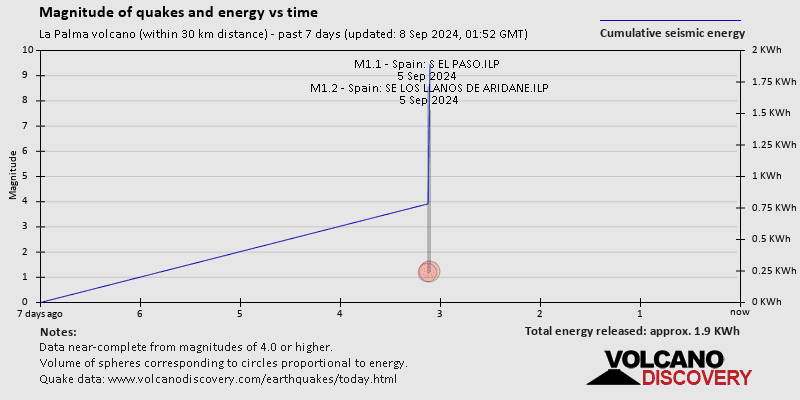
Eartquake rate seems much lower than past days. M 4.5 36 km just now.
es2021umwks 19/10/2021 14:10:17 15:10:17 28.5824 -17.8180 36 4.5 mbLg Sentido SW VILLA DE MAZO.ILP
Another 4.3 Mag at 23 Km depth
One more of 4.5 magnitude 36 Km deep
So three consecutive earthquakes of magnitude 4.6, 4.3, 4.5 at depths 22, 23, 36 km
https://twitter.com/NaqNab/status/1450469101466537987
4.5 only in IGNs list, the others must have been downgraded.
This video shows the location of the above mentioned smokey new vent.
Also quite a nice overview.
https://youtu.be/whE2Gwpm0AA
Hope the link works.
6,4 near Rhodes: https://www.independent.co.uk/news/world/europe/greece-earthquake-today-live-rhodes-b1940910.html
Something is not right with the vents now, much brown smoke on the west side of the cone at 18:22 pm CET, see https://www.youtube.com/watch?v=X4wjiJ6qc-E and the other camera just shows dense black smoke https://www.youtube.com/watch?v=INvrtMg5tSQ but coming from the active cone definitely, not the new vent.
dense black smoke from the southmost vent now shown in the first camera
way too much smoke coming from the active cone, very black smoke from the southmost vent
Eastside of active cone complex starting to steam brown smoke now at 18:31 pm CET so the cone complex is heating up.
I took 6 quick screenshots of the smoke the name of the snapshot shows the capture time https://drive.google.com/drive/folders/1aSSx9x2ktAJ5oVU7FHmM0aLmbAg8hU_E?usp=sharing
file capture time is Pacific Daylight Time, so +8 hours has to be added to obtain local La Palma Canarian time.
updated to a dozen snapshots and the time adjusted to Canarian time (+1 UTC)
Do you think that the volcano has encountered an internal problem (error)?
Maybe the problem will clear the crisis altogether..? (Permanent volcano shutdown)
Volcanoes don’t have problems, but they love to give them to everyone! Smile as you get yours!
Question: Is Opala a volcano that could reasonably go into VEI 6-VEI 7 eruption sometime?
Are there any recent large caldera’s in Kamchatka?
The Smithsonian site says that it created a VEI 5 in 610 ± 50 years. Mainly Basalt / Picro-Basalt, Andesite / Basaltic Andesite, but it does have some Dacite & Rhyolite. I guess there could have been some past eruptions that haven’t been documented that reached that.
As I’m an absolute non-geologist, what is “Smithsonian site”?
I don’t think you are referring to this? https://en.wikipedia.org/wiki/Smithsonian_Institution
The Smithsonian has the site https://volcano.si.edu/ but strangely it seems down at the moment [service temporarily unavailable]
Thank you so much! I particularly appreciate that they provide the rock types there 🙂
Yeah I noticed it was down, had to view it in cached mode.
The first question is intriguing, as conflicting information on the internet exists. One site says no evidence of recent eruptions exist. However on the Russian volcanic information server kscnet, I did pull up this publication: Melekestsev IV, Felitsyn SB, Kirianov VYu (1991) Opala volcano eruption. A.D., 500 – the largest explosive eruption on Kamchatka in our era. Volcanology and Seismology 13: 21-36 which seems to indicate a large eruption
http://www.kscnet.ru/ivs/volcanoes/holocene/main/textpage/literature.htm
http://www.kscnet.ru/ivs/volcanoes/holocene/main/textpage/opala.htm discusses the volcano, but does not peg the eruption level
http://www.kscnet.ru/ivs/volcanoes/holocene/main/largimgpages/opala/opala_fig1.htm looking at the volume of tephra emitted, 9-10 km^3, this would be a strong VEI 5 eruption, but not a VEI 6.
In regard to your 2nd question, looking at the volcano map http://www.kscnet.ru/ivs/volcanoes/holocene/main/main.htm and clicking on the volcano in a caldera configuration shows no recent caldera formation.
It is interesting that between Viliuchinsky and Kozelsky volcanoes is a big circular caldera now flooded with sea water suggesting a large explosive eruption at that location. The city of Petropavlovsk-Kamchatskiy on the north side, its population is 179,780 people.
The next caldera lake northward is Ozero Karymskoye (similar to Oregon’s Crater Lake) See the bottom most photo on Google maps https://www.google.com/maps/place/Ozero+Karymskoye/@53.9831186,159.4693088,3a,75y,90t/data=!3m8!1e2!3m6!1sAF1QipMX8hjr7lKYkxt8edb6iiyfHUTSSk4daelfhR06!2e10!3e12!6shttps:%2F%2Flh5.googleusercontent.com%2Fp%2FAF1QipMX8hjr7lKYkxt8edb6iiyfHUTSSk4daelfhR06%3Dw203-h128-k-no!7i1860!8i1181!4m5!3m4!1s0x591d9e7540e29c8f:0x68344bb272105abe!8m2!3d53.9831186!4d159.4693088
https://earthobservatory.nasa.gov/images/4826/ksudach-volcano-kamchatka-russia appears to be a VEI 5 eruption in 1907 and there are caldera lakes now, but I wouldn’t classify this as a large caldera recently formed, but rather smaller caldera inside a larger caldera.
Some hours ago. I not geolocalize them.
https://twitter.com/ElTimeLaPalma/status/1450468373167489026
https://twitter.com/involcan/status/1450513353495961607
Implementation of a DAS system to strengthen the seismic-volcanic surveillance of La Palma
Lava into La Laguna, a warehouse near the la laguna school.
https://twitter.com/ElTimeLaPalma/status/1450532724817678340
– Red the lava flow
– Green, the on flame green warehouse and the camera arc
– Blue, the school, CEIP La Laguna
New vent behind the tall one?
look closer to me than the one 400m behind the cone
4 vents, lava in all of them, looks like it is celebrating its 30-days jubilee hard 😮
Previously partially submerged ships at ivo jima are on dry land
https://www.thenationalnews.com/world/asia/2021/10/18/volcanic-activity-raises-japanese-island-exposing-sunken-second-world-war-ships/
*are now mostly on dry land.
Yes, I had been following that on the satellite images. They have been visible for some years now, and becoming more and more obvious
It is almost insane how fast that island is inflating.
I wish we had access to the GPS system on the island.
or SAR?
maybe https://www.capellaspace.com have some data (not open).
25cm in La Palma is good size and we would not notice on submerged ships.
Just happened to re-read the Ioto article a few days ago, it’s extraordinary the level of inflation over such a long period. Is Nishinoshima a bit of a risk too? I seem to remember it stands on the precipice of a graben and keeps ramping up it’s eruptions, bimodal eruptions too by the looks of it.
Nishinoshima would be a bother if it galumphed down the slop, but it is comparatively small, so not much more than a bother.
I remember seeing multiple articles that Ivo Jima is the most likley candidate for the next major caldera forming eruption ie VEI 6-7 range.
Hihi, the origin for that is our New Decade Volcano Program 🙂
You can find all of them listed above under the header named NDVP.
IGMA videos
4th vent
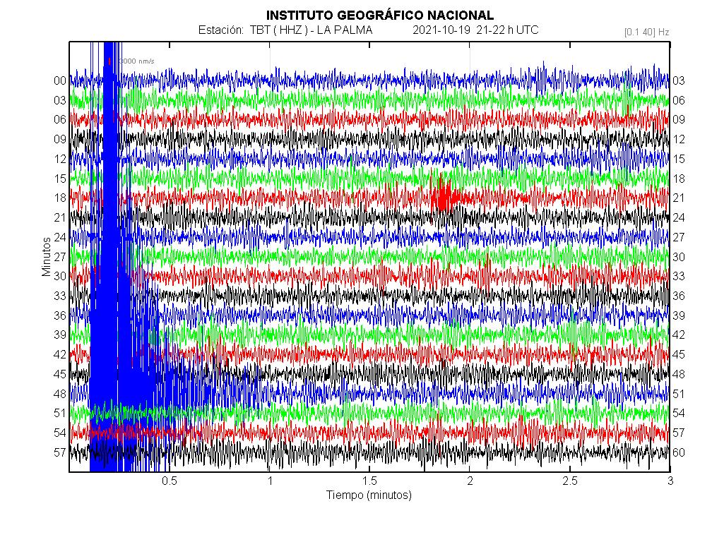
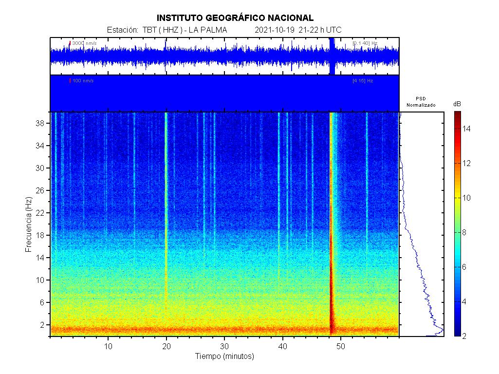
La Palma’s earthquakes of the last eight days, ordered according to their depth:
Nice!
Time/Magnitude shows nice clusters. Seemingly those clusters start with M 2-2.5 and end with about M 3.5 within hours. Esp. those on Saturday – and monday morning.
Thx. We saw this also in Iceland: short lived clusters of quakes with ranging magnitudes. I bet the experts know more about this phenomenon.
Not sure, but the 3.0+ has start to raising and depth making more shallow
The four vent has more active with piroclastic flows.
Now…. OMG…
4.9 mbLg SW VILLA DE MAZO.ILP 2021/10/19 21:48:00 37 +info
So when do we take a bet for a mag 5 or 5+ earthquake? This week? Next week?
La Palma day 30 drone footage ..
https://twitter.com/Arritrancos/status/1450583360212979713
This video – thank you – is very beautiful if not romantic and also extremely sad, therefore appropriate and excellent.
Spanish authorities just give the alert that in next days they can have quakes biger than M5 in La Palma…
What is this suggestive of? What’s causing the intensity of individual quakes to increase again?
This is speculation from my side, but we have seen previously that removing a lot of magma from a magma chamber can cause a series of M5+ quakes. This happened both at Bárdarbunga and Kilauea, as the rock above the magma chambers subsided.
When magma is removed from a magma chamber, the surrounding rock will deform. Initially, this is mostly an elastic deformation, but at a critical point the rock will fail and you get earthquakes. I remember reading a paper about Bárdarbunga where it was estimated that the critical point was reached when about 0.1-0.2 cubic kilometers had been removed from the chamber. That’s about the same ballpark figures as what has currently been erupted in La Palma.
My guess is that the rock above the deep chamber is subsiding and that the elastic part of the deformation is done, therefore earthquake activity is intensifying. At both Bárdarbunga and Kilauea the chambers where shallow, so they were caldera forming events. At Cumbre Vieja the large quakes happen much deeper and I don’t think they will cause a caldera.
End of speculation.
Bardarbunga was a deep plug piston collapse .. a cylinder was the caldera Plug.
Kilauea was a draining of a shallow magma column and uppermost magma chamber lava lake feature .. and it all caved in…
They are very similar .. yet very difftent 2014 and 2018
The larger earthquakes are at depths of c35km. Isn’t that on the deep side for caldera formation? – it’s well below the Moho.
No expert, but wouldn’t caldera forming eqs be in the 5km to 16km depth range? If not shallower?
It is a fissure swarm on a fault system, so there is dyke swarm there, and as the magma is removed the side towards the ocean moves a little downwards and outwards.
We saw this during Kilaueas rift eruption a couple of years ago.
Please, this is not unusual, and is not a sign of a big slide causing Florida to explode out to Jupiter, or something equally ridiculous.
When I wrote my comment, I had figure 6 from this paper in mind:
https://www.semanticscholar.org/paper/Magma-storage-and-underplating-beneath-cumbre-vieja-Kl%C3%BCgel-Hansteen/5d610145007dfe9d8ab624fce3f1216c3f26bffd
In Quinauberon’s figure above. it’s clear that earthquakes happen at two distinct depths, which suggests that there might be some merit to the two different levels of magma storage indicated in the paper. My intention was not to suggest a caldera collapse is going to happen, nor was it to say that the ridiculous mega tsunami scenario will play out. Instead, I meant to say I think that quakes happen because stuff is removed from the system, rather than because stuff is added to the system. Of course, removing stuff from the lower part of the system will add stuff to the upper part, but it’s at the lower part the larger quakes happen.
Can’t read the whole thing. Useful literature list though, thx.
What are the building codes like in La Palma? We have had many quakes but little comment on structural damage.
Up until now ash and lava have been the main hazards.
Earthquake corrected:
– 4.8 mbLg SW VILLA DE MAZO.ILP 2021/10/19 21:48:00 V 39 +info
The more big earthquake of all serie. Intensity V.
I’ve read that the eruption on La Palma as of the 19th had reached a VEI 3 as it’s ejected >10 million m³ of ash since the start. Making it the most explosive historical eruption on the island (based on known records).
Pretty decent phreatic blast at Mount Aso about an hour ago.
https://twitter.com/BNONews/status/1450659650563710976
Live webcam…scroll back and one gets a good view, lots of people running from the paddock.
What was the Japanese time stamp, please?
https://youtu.be/oOO70B1LpQg shows 2 orange dots in the photo and one star in the sky while the FAF seismo trace gets fuzzy at Geldingadalir Iceland now
I just see that Bárðarbunga can erupt rhyolite? But there isn’t a subduction zone there, so how come it can do such an evolved magma?
But Holuhraun 2014 was primitive basalt, wasn’t it?
Not strange at all … can happen anywhere on Earth
It just depends how long the magma sits in the ground and how old it is.
When Hekla is dormant for long periods, she becomes dacite even ryholite …
When she is frequently active the magma may become as fresh as basaltic andesite or even basalt.
It depends how fresh the magma is and nothing else
Hekla is not a mystery magma either
It just depends how fresh the magma is.
I see, but isn’t it that in subduction zones the volcanoes tend to be more explosive?
And also dacite/rhyolite tends to be more explosive?
Can we say that around subduction zones the magma tends to get older?
Other question, has Kilauea been explosive once?
Teide, Azores haves old gassy magmas and are explosive .. Despite being hotspot .. haves nothing to do with tectonics
Many mature Subduction Zones haves a very thick crust that the magma must go through first .. increasing the size of sillica richness on the way up
Kilauea haves an insane magma supply .. and generaly always produce relativly fresh basaltic magmas. You can get basaltic plinians in Kilaueas caldera hell sized lava fountains and tephra
Kilaueas magma supply is way too high for any sillica rich caldera events ..
Kilauea haves too much fresh magma input for that
Sometimes you get separate pockets of magma or chambers that develop in the deep plumbing of a volcano. If one such chamber was closed off for a few thousand years or was only sporadically connected, you might end up getting magma that develops to become more mafic and silica rich. It could also be that the chamber has layers (fractional distillation?) where there’s a certain percentage of say andecite and rhyolite, and intermediate magmas, but most is basalt or tephrite.
Dacite and rhyolite are essentially more explosive because they traps high amounts of gas inside the crystals, so a closed or unerupted chamber might not have a gas outlet so it builds up over time.
I believe it was the Tarawera eruption in New Zealand where a basalt dike shot up from deep and may have hit a rhyolite mush causing the VEI 6 eruption.
Silicic magmas like dacite or rhyolite are more explosive, but there are other reasons too why subduction zone volcanoes are more dangerous. Basaltic volcanoes in subduction zones tend to be much more explosive and dangerous than basaltic volcanoes elsewhere.
One reason is that the magma is gas rich. Magma carries water obtained from the subducted slab. Also most volcanoes in these areas are stratovolcanoes. Such stratovolcanoes have very steep slopes that lead more easily to lahars and pyroclastic flows, and erupt repeatedly from the vent at the summit. The main conduit of a stratovolcano is possibly enlarged after centuries or thousands of years of usage so it is wider and allows magma to rise faster.
Kilauea has also produced some substantial explosions. An explosive eruption in 1790 produced pyroclastic flows that probably reached up to 12 kilometres from the vent towards the southwest and killed many native hawaiians. It is not entirely clear why these explosions happen although I see evidence that they are linked to major caldera collapses. The caldera collapse is caused by an effusive eruption on the flank but may also cause explosive activity at the summit, of small volume but considerable intensity. The last explosion in 1790 seems to be related to the formation of Kilauea Caldera, the one that is now almost filled up completely.
Cough, it is good to remember that the Icelandic lava is the most gas rich known to man, this is why the andesite out of Hekla is so darn explosive in the first hour or so.
Instead it is water that is the volatile compound in subduction volcanism that is driving the explosiveness.
Basaltic subduction zone volcanoes are quite explosive. The idea that basalt behaves nicely comes from gas-poor (water and carbon dioxide poor) basalts of places like Hawaii, Iceland, or Reunion.
To put an example, Ulawun volcano erupts fluid basalt, but it has also produced multiple VEI 3/4 eruptions historically. Combined with its steep slopes its eruptions result in dangerous pyroclastic flows. There are many subduction zone volcanoes that behave similar. Ulawun going off in 2019:
https://appliedsciences.nasa.gov//sites/default/files/ulawen-image.jpeg
Thats why many Basaltic Stratovolcanoes are also so steep and beautyful.. the most perfect cones on the planet
They erupt very tall lava fountains and lava flows from the same vent frequently, gaining steeper slopes than many other more sillic volcanoes.
Shishaldin is a perfect of a basaltic subduction beauty! Its just a few thousand years old and built pretty much entirely of tall lava fountains
Its as close to Mount Doom as its possible to get.
Nyiragongo maybe was like Shishaldin before its summit caldera formed. A mafic rift stratovolcano
There are other volcanoes in the East African Rift that make nice cones too. Ol Doinyo Legai for example, large nephelinite lava fountains must have constructed that mountain.
Nyiragongo does have a beautiful conical shape. You only get such perfect symmetrical cones from high lava fountains.
Carl Hawaii is just as Sulfur Gas Rich ..( perhaps ) even more so than Iceland. ..
Leilani eruption had a sulfur output that was perhaps greater than Holuhraun.
2018 was so very sulfurious that most of the vegitation in lower puna died .. and it became Impossible to breathe for many of my friends. Very very acid enviroment Kilauea produced in 2018. My friend Yvonne moved to to mainland unable to breathe in Keeau during the 2018 eruption
1983 – 2018 eruption and specialy Halema’uma’u have also produced Insane ammounts of Sulfur per day.
The air quality been very poor over the Big Islands and the Islands .. with thick volcanic smog even in Honolulu. The toxic emissions been drifting for 1000 s of kilometers west for 36 years.
Hawaiis lavas are just so fluid that the sulfur degasses out of Halema’uma’u constantly
I think Hawaii and Iceland is similar in sulfur budget
The thing is that sulphur dioxide is not such an important gas when talking about explosivity. Kilauea for example is one of the most sulphur rich volcanoes in the world but still the main volatile that it contains is water. Kilauea has 0.4 weight% water, 0.2 weight% sulphur dioxide, and 0.04 weight% carbon dioxide.
When talking about the explosivity of volcanoes water is the main driver. Subduction zone basalts contain usually 4 wt% water, 10 times more than Kilauea… Mid ocean ridge basalts have around 0.1 wt% water and are thus the least explosive magmas in the world.
Grimsvötn is sourely very very sulfur gas rich .. it was the sulfur that drove the 2011 violence
But Kilaūea have produced similar Ice free events in Halema’uma’u earlier
Showering the whole summit arera in black brown pumice,
Still it will be fun When Grimsvötn wakes up next time. Next time maybe longer lived and of less violence than 2011
Perhaps enough for an Island in the caldera.
Huge sulfur emissons was reported spring 2020 from Grimsvötn
Wheeww should’ve asked that question in VC Café post 🙂
Thank you very much, all of you, I think I begin to grasp the concepts more.
La palma, a better video from the 4th vent by IGME
Thank you very much, best view I’ve seen. How long has this vent been going? I think I first noticed it a few days ago.
In response to Lakikigar/Randall above:
If you’re interested in Kamchatka biggies, check out Pauzhetka caldera, which essentially had Diky Greben and Kurile Lake calderas as a side show. Erupted roughly 420,000 years ago, VEI 7.6. The caldera is 20 x 25 km.
La palma, More videos of IGME:
Nocturnal volcano view from east, show all vents and coladas.
https://www.youtube.com/watch?v=Ed6iudVcu9w&ab_channel=InstitutoGeol%C3%B3gicoyMinerodeEspa%C3%B1a
Taking velocity measures on Tacande zone. 10 meters / Minute.
https://www.youtube.com/watch?v=BTdUgagBNwE&ab_channel=InstitutoGeol%C3%B3gicoyMinerodeEspa%C3%B1a
AA lavas on Tajuya
https://www.youtube.com/watch?v=b9rdQ41byZ0&ab_channel=InstitutoGeol%C3%B3gicoyMinerodeEspa%C3%B1a
Other big block over the lava on Tajuya
https://www.youtube.com/watch?v=fplsPvaTHlw&ab_channel=InstitutoGeol%C3%B3gicoyMinerodeEspa%C3%B1a
The yesterday 4.8 Earthquake:
Waiting about a new drone overfly to check the La Laguna zone.
Mount Aso has erupted in Japan. A small but sudden explosion. There is spectacular footage:
https://www.youtube.com/watch?v=Xi36UGVSpVU
I hope there was no one hiking too close to the crater. With some volcanoes its best to just stay away, they aren´t safe. As shown in the video they can change suddenly from dormant or mildly active to full eruption. The pyroclastic flows overtake you and that’s the end. Volcanoes with a semi-open conduit. Smoke coming out, occasional explosions, acid lakes…
In the video one can see how the pyroclastic flow is made. By pyroclastic fountain. The dense material advances over the ground as black clouds, the mixture then acquires buoyance and rises up into the air making a coingnimbrite cloud. There is a very common misconception that pyroclastic materials form because an eruption column collapses when it is actually all the way around. It always happens that pyroclastic flows initially come out from the vent as ground-hugging clouds, then later become buoyant and rise.
https://www.reuters.com/world/asia-pacific/japans-mount-aso-erupts-alert-level-raised-2021-10-20/
“Local police said there were no reports of people injured or missing as of Wednesday evening, and that 16 people who had gone hiking on the mountain earlier on the day came back safely.”
Thankfully it seems this wasn’t another Ontake or White Island.
Presumably what we saw wasn’t pyroclastic flow then but ash cloud. Certainly looked scary enough. Impressive video.
I was impressed by the single white car at 2.44, driving straight towards the eruption while the rest of the traffic is getting away.
Thanks for that. I’d be running around in circles in the car park. Meanwhile the Japanese drive away in an orderly manner without breaking the speed limit. Amazing folks!
There isn’t much to see here right now. Hopefully, there will be a better live cam’s available soon.
https://eruption.acme.to/mount_aso.php
La palma, by Involcan, the lava reach the gas station, near the crossroar on La Laguna. 🙁
https://twitter.com/involcan/status/1450804651524333574
Map update, That show the lava on gas station (that is not a danger, was empty some days ago) and near the CEIP School of la laguna. The lava go to the La laguna / Tazacorte road.
Volcano (Palma) seems very quiet – not much smoke, steam or ash, a lot of gas and the occasional rock from the top vent. Hard to tell if lava is still coming from the bottom vent, nearest to the camera.
Hugh Mann, the La Palma TV has better angle, that show lava on the bottom velt.
https://www.youtube.com/watch?v=X4wjiJ6qc-E&ab_channel=TVLaPalma
Has building a lava tube on the exit channel, I think.
Same channel of bottom velt by the IGME.
https://www.youtube.com/watch?v=TNS-536dx8E&ab_channel=InstitutoGeol%C3%B3gicoyMinerodeEspa%C3%B1a
10 meters / second and 15 metters high.
Thank you. Muchos gracias.
Another one…
High-level eruption at Manam volcano, ash to 15.2 km (50 000 feet) a.s.l., P.N.G.
https://twitter.com/TheWatchers_/status/1450793678595788807