
In the previous post, we read about the birth of Surtsey. It was a famous eruption, which taught us how quickly and unexpectedly new land can form.

We have since seen similar eruptions elsewhere as well. Nishinoshima is a small and isolated Japanese island, 1000 kilometers south of Tokyo. An eruption started just off its shoreline in November 2013. It was a classical surtseyan eruption, and it quickly formed a new island while the eruption became strombolian. Over the next three years, the new island merged with Nishinoshima and more than doubled its size. A look under water explains what happens. Nishinoshima is the top of a very large volcano, of which the flat summit is mostly just below the sea surface. The eruption happened on the summit but beside the highest cone – which was the only part seen above water.
All deep sea islands are volcanic in nature, and all came to be in this way: a series of eruptions building up a precipice until it rises above the waters. The volcano is already very tall by the time it reaches the surface. Many never do, whilst others continue to grow until they tower over the waves. From Anak Krakatau and Stromboli to Mauna Loa, the sea gives us some of our best volcanoes. They can grow higher than those on land, because part of the structure is below the water: the water carries part of the weight. To see such a volcano first reach the light of day is an impressive and memorable sight. It brings to mind Britain’s rousing old brexit hymn battle hymn, Rule Britannia! – Britannia rule the waves!:
When Britain first, at heaven’s command,
Arose from out the azure main
But there is something funny about Nishinoshima. The summit of the volcano was a large, flat plateau just below the water surface. Why was this? It seems an unlikely coincidence. But there is in fact a reason why there was a plateau, and why it was at this height: you may blame Britannia’s waves. Like an anxious boss, they continuously stamp down on anyone who dares to put a head above the parapet and threaten the pecking order. Rule Britannia depicts an inverted view of the world. In reality, the waves are not there to be ruled – they are the ones in charge. They are the rulers of all, and overpower anything that tries to interfere with their domain.
The sea does not tolerate summits. It demands a level playing field, and it achieves this by attacking heights. The sea is a tyrant that aims to bring down what rises above; it has a powerful attitude, and it gives rise to a plateau of mediocrity. Hence the flat submarine summit of Nishinoshima, located just below the depth to which waves penetrate.
The nations not so blest as thee
Must, in their turn, to tyrants fall
But to a volcano, a level playing field provides an opportunity. Even the smallest eruption can create a notable peak if it happens on a tennis court. Like a celebrity tweet, it draws the attention to content that in other contexts would not seem so notable. This is true for Surtsey, and to surtseyan eruptions in general. Remove the sea, and these eruptions, while still significant, would not seem so outlandish.
There are many examples of submarine plateaus summits surrounding a minor island. Iwo Jima (nowadays known as Iwo Ioto) is one such, and as the underlying volcano inflates, the island grows and grows. Various sources state that the Iwo Ioto plateau is a caldera, but there is not much evidence for that: it seems like a normal wave-battered summit. (If it really were a caldera, the inner regions would have been much deeper.) The Aleutian eruption of Bogoslof is another case. Various peaks around Bogoslof show previous eruptions, and as the eruption center moves around, it almost causes the island to wander. Bogoslof is in a battle with the elements. The waves erode, the eruptions build up, and the winner remains undetermined. It sails close to the wind. But if the eruptions will come fast enough and are voluminous enough, it may rise above the sea far enough to gain some stability. Rule Britannia suggests such a battle between water and volcanoes:
Still more majestic shalt thou rise,
More dreadful from each foreign stroke,
As the loud blast that tears the skies
Serves but to root thy native oak.
Mathematic interlude
A volcanic island grows as the lava flows reach into the surrounding sea. We have seen this happen at Kapoho where a tropical bay became a basaltic desert. At the same time, erosion by the waves reduces the size of the island. If the growth and the erosion balance, at least over the long term, the island keeps a constant size.
Let’s assume that the eruptions create new land at a rate ‘A’, which is measured in square meters per year. We ignore lava that solidifies on land and may build a cone: only the lava that encounters and expels the sea counts. (If the island is very large, sediment carried by rivers will also build new land which should be included in ‘A’. But we are now looking at smaller island which lack such rivers.)
The waves attack the coast and cause it to retreat. Let’s call the speed of coastal retreat ‘C’, measured in meters per year. The island loses a total area each year which is equal to this ‘C’ times the circumference (assuming the rate is the same all around the island – this may not be true). For a circular island, the area lost per year is equal to 2πrC. The island is stable if the gain and loss balance: A = 2πrC.
The value of ‘C’ can be measured. Let’s assume for now that it is equal to 1 meter per year. In that case, if the island is 1 kilometer in radius, it loses an area equal to (2π) times (1000 meters) times (1 meter/yr), which is just over 6000 m2 per year. To be stable, over time eruptions need to create the same amount of new land per year. If the island erupts once per century, each eruption would need to form 100 times mores, or 0.6 km2 of new land. If it erupts more than this, it can maintain a larger island – if less, smaller. A four times larger eruption rate will maintain an island with a four times larger radius (and thus 16 times larger area). The radius of the island will roughly be given by the equation r=A/2πC. If you know r and C, you can calculate A: you know how much new land the lava must have created over time.
But what if there are no further eruptions? In that case, erosion will continue to eat away the island. The length of time that the island will survive is equal to the radius divided by the erosion rate: t = r/C. An island with a four times larger radius will exist four times as long. For C=1 meter/yr, an island 1 kilometer in radius can expect to exist for 1000 years. Most of the area of the island is lost early on: after 500 years, half the life expectancy, the island is already reduced to a quarter of its original area. The island spends most of the years of decline as a small remnant.
So to survive, a volcanic island needs continuing eruptions. A monogenetic cone (erupting once) will succumb, whilst a regularly erupting cone can keep the waves at bay.
All their attempts to bend thee down
Will but arouse thy generous flame
But in the long run, all islands fail. No volcano lasts forever: eventually the waves will win and the sea prevail. One can hear the sea singing the words of Rule Britannia
All thine shall be the subject main,
And every shore it circles, thine.
Surtsey
After this introduction, let’s see how it applies to Surtsey. The island formed in a single event lasting three years, very similar to Nishinoshima. How is it faring in its battle against the sea? And what lies beneath?

The map above shows the location, off the coast of southwest Iceland. It is a continuation of the eastern rift zone but it is not yet rifting. Give it another million years for that. The main island in the area is Heimaey. There are a number of much smaller islands, of which Surtsey, at the end of the arc and furthest from the main land, is the largest and youngest. It formed in the 1963-1967 eruptions when several eruption centers were active. The eruption started out as a shallow underwater, phraeto-magmatic event. Once the cone was secured against intruding sea water, the eruption became strombolian, producing basaltic lava. The type of eruption is important: surtseyan explosion produce weak conglomerates of tephra which can erode fast, while strombolian eruptions produce tephra, tuff, and lava flows. Hardest of these is the tuff. Note, however, that the important factor is the strength of the rock at sea level. Having harder rocks higher up the cone does not help if it is all undermined from below. The sea can be a sneaky neighbour.
During the Sursey eruptions, there were satellite eruptions which also attempted to form islands: Surtla, 2.5 km to the E-NE, Syrtlingur in the same direction but closer, and Jólnir on the opposite side flank. Surtla never showed above water, but both Syrtlingur and Jólnir reached 70 m above sea level. Both islands consisted of tephra which was washed away within months.
Surtsey itself was not particularly resistant either, although to its credit it does live in a very hostile environment where the storms, waves and currents are severe. By the end of the eruptions, in July 1967, the island covered an area of 2.65 km2. In July 2012, only 1.31 km2 was left. The eroded debris build up some shallow shelves around the steep cliffs. These will have helped protect the island from the worst of the waves, at least temporarily.

Surtsey, 1 June 2018, as seen by Sentinel. The colours are shown greatly exaggerated: to the eye it is mainly dark brown.
The volcanic field
Look from Surtsey to the direction of the Icelandic coast (see the image at the top of the post), and a plethora of small cones can be seen above the sea. These are remnants of previous eruptions. There are more small remnants than larger islands. The calculation above in fact predicted this, provided each island formed in a single eruption and suffered erosion since. If, in contrast, the islands are stabilised by continuing eruptions, you expect fewer small remnants compared to the number of larger islands. The fact that the there are more small cones than islands tells you that this area is monogenetic. The archipelago of 18 islands and many more rocks act as a monogenetic volcanic center.
So the plethora of rocks shows that the region is very active, but that eruptions move around. Historical evidence is consistent with this. Recent events include an eruption in 1893 south of Hellisey, the much larger 1963–1967 Surtsey eruption, and the damaging 1973 Eldfell eruption on Heimaey. The majority of rocks, stacks and islands are close to Heimaey and this is clearly the focal region where most of the eruptions occur. But eruptions do not recur: there is no large volcano and each location indeed only erupts once.
Under water, the island chains sits on a 50 to 100-meter deep shelf, highest around Heimaey, build up by the volcanic activity. The linear chain of islands gives the impression of a central conduit (Heimaey) with dikes feeding the more distant eruptions. Surtsey is the most distant of these. The chain follows the direction of least resistance along the Icelandic spreading axis (although it is not itself a spreading ridge). This is what would be expected from a dike system. However, in that case you would also expect that activity along a dike is preceded by inflation and earthquakes at the central system, and no such events were reported at the time of Surtsey. The actual origin of the magma could also be further away, on the main land: the Surtsey lava had similarities to Eldgja. But again, there is no evidence for this. At Surtsey, the earliest lava was the most evolved and thus likely dated from an earlier intrusion. Later lava was much more mantle-like. But all this says is that the magma came from deep. It does not tell which pathway was followed.
Monogenetic fields occur where the crust is weak and instead of one single magma chamber there are a number of smaller, short-lived chambers. Magma finds easy pathways to the surface, and there is no need or advantage in using a previously prepared conduit. We may thus be looking at a large number of small magma chambers, most of which are around Heimaey but some further away, along the axis. The magma chambers are in pressure equilibrium with the much deeper magma from the mantle. During an eruption, the pressure in the upper chamber drops as magma escapes, and this sucks in the deeper magma, over a time scale of months to years. This continues until the pressure difference between the upper and deeper chamber drops below a critical value. This model explains why the field is monogenetic, why eruption last years, and why the magma quickly becomes very primitive. It does not explain why this is happening at this location, southwest of Iceland. Perhaps this is the way that spreading centres develop: they start out with a line of weakness, where the sides are slightly pulled apart, allowing these magma chambers to form, whilst the weak crust lacks the strength of a captain Picard, feels that ‘resistance is futile’, and quickly gives in to the rising Borg magma.
Surtsey’s decline
Surtsey exemplifies the weakness of volcanic rock. By the end of the eruption, it consisted for about 70% of lava flows and 30% very porous tephra. The lava reached thickness up to 100 meter near the eruption center, but at the coast the flows were typically only 1 meter thick. Both the tephra and the lava were extraordinary weak, and rapidly retreated under the onslaught of the Atlantic ocean. The erosion was strongest on the southwest side where most of the waves came from. The opposite side was more protected, both by the main land and by the dominant wind direction.
But over time, the island hardened and adopted more of a USS Enterprise attitude. The tephra reacted with hydrothermal water, and this turned into a much denser and harder tuff. By 1985, the remaining tephra had been removed and the erosion began to attack the tuff. But the hardened tuff was far more resilient against the sea.

Fly-over images, National Land Survey of Iceland

The images here show how Surtsey developed during the eruption and since. The coast retreated fastest in the west and southwest, where the waves were most severe. Over time, the southwest side became a straight line, perpendicular to the prevailing wave direction. In places, it had been pushed back by 300 meters. On the west side, the sea was eating into the side of one of the craters. Before 1985, this side was tephra but later the waves encountered the far harder tuff and the erosion slowed down dramatically. There is now a 130-meter tall cliff here, protected by the hardness of the rock and by a boulder beach. The beach is clearly visible at the bottom of the cliff, and it causes the waves to break and lose some of their power. Beaches are a good investment for a volcanic island.

On the south and east side, the sea is eating into lava beds. Here the cliffs are not as tall, and frequent collapses have created large boulder beaches. The boulders are rapidly rounded by the waves. The much harder tuff in the west has produced a much less pronounced boulder beach. The tougher the cliff, the less effective its beach will be. Strength can sometimes be counterproductive.
The waves and currents are transporting the boulders along the coast – after all, rounded boulders roll rather easily. They have collected on a spit which developed on the north side after 1970. This is the only part of the island which grew after the eruption had ended. The volcanic sand and boulders give the spit an inhospitable appearance! The time series of images show that the spit migrated eastward in later years. This was because of the tuff. On the west side, boulder formation became much reduced after 1985, and thus the spit lost some of its supply on that side. On the east, boulders continued to be available. But in recent years, especially since 2012, the spit has narrowed and moved a bit westward as the supply on the east side also no longer keeps up with spit erosion.

The North spit. Photo: B. Magnússon, 2014
There is a very different landscape underneath the sea. The satellite volcanoes which formed during the Surtsey eruption are still there. They eroded very rapidly to a depth of 25 meters (Surtla had only just reached that height), but the erosion slowed down after that. As of 2007, the plateaus of Surtla, Jólnir and Syrtlingur were 51, 43 and 34 m below the surface. The lesser depth of Syrtlingur reflects the fact that it is shielded from the stronger waves on the southwest side. Their summits have also become wider, because some of the debris from Surtsey found its way to the submarine peaks of Syrtlingur and Jólnir.
Surtsey is surrounded by a plateau, 20-30 meters below sea level, with very steep edges going down to the original seabed, 120 meter deep. The plateau extend furthest from the current island on the southwest side, where it approximately follows the original, 1967 extent of the land. The plateau is covered with debris and boulders, debris from the erosion above the water line.

The erosion rate of Surtsey has been very changeable. The highest rates were seen during the eruption, when the unconsolidated lava and tephra retreated by 30-100 meter per year. The eastern lava cliff retreated by 100 meter in 1966 due to a single severe, easterly storm. After the eruption ended, the southwestern lava cliffs continued to erode, at first at a rate of 30 meters per year, later reducing to around 12 meter per year (average over the period 1967-2012). The more resistant northwestern side eroded at 30 meters per year during the eruption, but this rapidly became less as the tephra hardened and at present it retreats at no more than 20 centimeters per year. Tuff is tough.

In 50 years, the island has halved in area. But this has not happened at a constant rate. Between 1967 and 1985, 1 km2 was lost, or roughly 0.05 km2/yr. Between 1985 and 2015, 0.5 km2 went, or less than 0.02 km2/yr, which is a much slower rate. The erosion is meeting more resistant rock, and is slowing down, and as the island becomes smaller, the waves attack a smaller circumference as discussed above.
What does the future hold? If the erosion rate had been constant, the whole island would be gone within 200 years, by 2150-2200. But the rate is getting smaller. The erosion will continue to remove the lava shields. In another 50 years, those lava flows will be largely gone. The spit will also have disappeared, and only the double cone will be left. The tuff of these two cones will be around for much longer. At an erosion rate of only 20 centimeters per year, they should be able to last two thousand years, perhaps longer.
Erosion rates
In the interlude above, we used a parameter C, which is the speed at which the coast retreats each year through erosion. But this is clearly not particularly constant. At Surtsey, the speed varies along the coast line, and it also changed with time, between 100 meters per year and 20 centimeters per year. Clearly, the assumption that C was ‘a constant’ is a little too simplistic!
Surtsey is probably a typical example of the destruction of a volcanic island. The highest erosion rates occur during and shortly after the eruption, when the waves attack loose tephra and soft lava. Decades later, the rates slow down by a factor of 100 or more as the tephra has hardened. This means that a volcanic island has a rapid growth spurt during an eruption, followed by a fast retreat, but is much more stable (and much smaller) a few decades after such an eruption. With a rate of 12 meters per year over the first 30 years, an island can only survive this phase if it starts out with an area of at least 0.1 km2. Eruptions smaller than this will create a rather ephemeral island. If the eruption is larger, it can last until the erosion drops by a factor of 100, and it will survive, perhaps as a stack, for very much longer. The current rate of 20 cm/yr appears typical for later phases. For the much larger and older Bouvet island we estimated a similar rate, of around 10 cm/yr.
Wave erosion is very important to volcanic islands. But it is not the only type of erosion. Especially if the volcano builds up a cone, it will attract rain, and this will attack the island from above. However, this mainly reduces the height and makes the cone much steeper; it is much less effective in reducing the size (and the sediment an even temporarily enlarge the island). Rain does not in itself reduce the longevity. However, steep cones can become unstable, and lead to land slides which can remove parts of an island altogether. Hawaii has suffered tremendous landslides, which have taken big bites out of the coast line and left debris on the ocean floor one hundred kilometers away. Such slides are rare: on Hawaii, they happen perhaps once every 100,000 years. But if they put the coast back by 10 kilometers, that is similar to what an erosion rate of 10 centimeters per year would do over the same time. Rare but catastrophic events can significantly increasing the total erosion rate. Surtsey is unlikely to suffer such a land slide, as it lacks a steep cone. An extreme storm could however have an impact.
The Surtsey volcanic field
Looking at the Vestmannaeyjar archipelago, cones seem to be sticking out above the sea everywhere you look. Each of them once was an island like Surtsey, now reduced to a central tuff cone. There are 18 islands in the archipelago, and another 25-30 rocky outcrops. Assuming that the cones survive for a few thousand years, this suggests one Surtsey-like eruption per 1 or 2 centuries. But Heimaey itself has lasted much longer. It contains both the oldest (10,000 years old) and the youngest (1970’s) rocks of the archipelago. This is the only island in the archipelago with repeating eruptions, needed for longevity. All others had only a single eruption, as a monogenetic cone. It does not mean that Heimaey is different. This is the centre of the field where eruptions are most frequent. The island was able to grow large enough that other eruptions occur on it before the island has had time to disappear. This has made the island stable. All known vents (10 in total) on the 13 km2 large island are in fact also monogenetic.
Under water, there are many more remnants, perhaps some 70 volcanic cones in total. After the waves have removed the upper parts, 50 meters below the sea the cones can last a long time, suffering only a bit of erosion from currents. If we assume as eruption rate of one or two per century, the number of volcanic cones suggests that the archipelago is around 10,000 years old.
This is uncomfortably young. A volcanic area does not pop up out of nowhere in such a short time. And rifts don’t move much on such time scales either: they extend by at most a few kilometers, far smaller than the archipelago is long. You would expect the volcanic environment to have been very similar even as long as 100,000 years ago. What happened to the volcanic cones that formed before 10,000 years ago?
The likely answer lies in another factor that we have ignored. Wave erosion happens at sea level. But sea level has not been constant. 20,000 years ago, it was over 100 meter lower than it is now and the region of the Vestmannaeyjar archipelago would have been dry land. When the sea came in, as the ice age was melting, it would have attacked any volcanic cones from ground level up. An erosion rate similar to what it is now would have quickly removed the entire volcanic history of the region. After that, volcanic building work had to start from scratch. This is the reason for the short history shown by the archipelago. It doesn’t mean it is new, just that someone erased the earlier writings in the book of history. This was a monogenetic volcanic field long before the oldest surviving cones formed.
(Of course, the area would also have been covered by ice age glaciers, and they may have done even more damage. There is normally more than one party trying to rewrite history.)
What will happen in the future? At the surface, not much will change. New islands will come, old ones will go. Only Heimaey will survive. But below the surface, the series of eruptions will slowly build up the sea floor. Eventually, there will be a ridge here extending from the shore outward, some 30 meters below sea level. Eruptions appear to be too infrequent or not voluminous enough to get beyond that. It will not be another Reykjanes peninsula: it will stay under water. But in another 100,000 years, it may get close to the surface. But no further. Any higher, and the jealous sea will strive to bring it down. Like Britannia, Vestmannaeyjar will be ruled by the waves.
Albert, September 2018


Even here can’t escape brexit!! 😀
The geology of Icelandic is fascinating. Especially since most of the volcanic activity over at least the past 2 million years would have been subglacial. I bet Iceland’s biggest volcanoes would now look much more like Hawaii’s shields if everything had been subaerial. I am guessing that miles deep ice sheets and basaltic lava do not generally get along well.
I think the best way to imagine the Icelandic volcanoes without there having been any ice would be to look at nyamuragira. It is on a crustal rifting zone above a big plume that is possibly in its early stages. Hawaii is rather different, the rifting in Hawaii is due to the mass of the islands sliding in preference to certain directions and then new volcanoes sliding at right angles to existing ones. It is possible that Hawaii only does this because it sits on very old ocean crust with a lot of sediment on it to act as lubricant, the volcanoes in the Galapagos erupt in an almost identical way to the Hawaiian volcanoes but those islands are on young crust with little sediment, and particularly the youngest volcanoes there are blurring the line between shield volcanoes and stratovolcanoes – wolf and fernandina have slopes of close to 40 degrees, that is very steep even for a stratovolcano let alone an effusive ‘shield’ volcano. There are a lot of these sorts of things I hadn’t thought about before but which make a big difference.
so the ocean both supports and erodes the volcanoes. Sort of like the ocean is playing with them like a bath toy……Understandable that ocean volcanoes have surrounding plateaues. i found this post very enjoyable.. Thanks! Best!motsfo
Better a bath toy than a dogs chew toy. Chew toys don’t fare so well.
Dawn Probes History of Cryovolcanism on Ceres
“…They deduced that an eruption might happen once per 50,000 years on average. Over time, these eruptions could disgorge about 10,000 cubic meters of briny slush onto the surface per year…”
The previous Volcanocafe article on Ceres by Albert. Dawn over Ceres: the lonely volcano
““If you look back 20 or 30 years ago, we [in the UK] really were a nation of instant coffee drinkers,” he says. “And the one thing that instant coffee didn’t really taste of was coffee. Decaff was even worse.”
http://www.bbc.com/future/story/20180917-how-do-you-decaffeinate-coffee
As a retired CPO, I find the concept of decaffeinated coffee to be somewhat obscene.
reading the method explains why decaffeinated coffee gives me a migraine.
That might actually be due to the lack of caffeine – one of the withdrawal symptoms is headaches/migraines due to the rebound opening up of blood vessels are increasing blood flow.
The benzene method gives me concern since that molecule structure is present in gasoline and everybody hoots and hollers about it’s potential hazards, though it’s probably a different molecule altogether. The supercritical CO2 sounds somewhat safe since it goes away once the batch is returned to normal pressure.
Personally, I take the “I’m in it for the caffeine” approach and shy away from decaff completely. If I want non caffeine… water does the trick just fine.
Dear GeoLurking, don’t worry, everyone using the benzene method today would be locked away very fast…even in the US… ;o)
I actually wasn’t aware, that there are still methods in use that use ethylacetate…yuck
And I really do hope they don’t use methylene chloride anymore, because this:
” In 1985 the US’s Food and Drug Administration said the likelihood of any health risk from methylene chloride was so low “as to be essentially non-existent”. ” is very out-dated.
Best thing is the CO2 method and as you get pure coffeine as a sideproduct which you can sell at the energy drink industry, I wouldn’t tell it “too expensive”…
^^
Turtlebirdman is right
Nyiragongo is an amazing volcano. A stratovolcano thats gone ultrabasic superalkaline and super- low in sillica. Nyiragongo erupts a Melilite Nephelinite magmatic composition, with 35% sillicon and 1250 C.
The lava is completely crazy fluid at Nyiragongo.. here is a good video https://www.youtube.com/watch?v=gIUTjaefr2s.
Temperatures was measured by Patrick Marcel in recent years as he and volcanologists climbed to the lakes edge. Due to the crazy low levels of silica, this creates foiditic rocks.
When I was smaller I have found photos of Nyiragongo 2002 or 1977 flow, thats milimeters thick and splashed against trees and the ground leaving a thin layer of glass on the ground.
I read that virunga national park is not acessible for the moment.
Nyiragongo once again haves the title of the worlds largest lava lake as Halemaumau drained.
But Kilauea being a more powerful magma system haves larger lakes when its realy going.
I have noticed that the lava lake in Halemaumau had a few large crustal plates and bubbling at the edges.
Nyiragongos lava lakes haves many small crustal plates and many small bubbles.
Both Kilauea and Nyiragongo are mostly fluid.. but Nephelintic melt are likley lower viscosity
1250 C is ptobably the hottest lava on earth, I think the core of the kilauea iki lava fountain was measured at maybe even 1300 C using an old optical pyrometer (it was yellow-white hot) but the lava was more normal temperature outside that, having a whole lava lake that hot is insane. I think maybe nyiragongos lava lake is deeper or has a bigger vent, halemaumau had only two small vents at the bottom of the lake while nyiragongo maybe has a lot more or simply a big open hole into the magma chamber.
Theres also some stuff on it here:
https://www.researchgate.net/publication/27774149_January_2002_volcano-tectonic_eruption_of_Nyiragongo_volcano_Democratic_Republic_of_Congo
This area is in desperate need of extensive study, even Naples is probably safer than being in Goma during an eruption and that is really saying something. The Virunga volcanoes are basically the first stage in a mantle plume reaching the surface under a rift zone, like Iceland but continental. The same thing happened in the Afar region 30 million years ago and created the Ethiopian highlands flood basalt province and might have had something to do with the ice ages starting. The rift outside this area is very similar to the baikal rift, it is largely non-volcanic and has also got lakes over 1 km deep, but then you get to nyamuragira and nyiragongo and they seem to have half filled a massive lake basin that lake kivu and lake edward are probably remnants of. Nyamuragira possibly only breached the lake surface 13,000 years ago, so it has grown extremely fast. Nyiragongo might have changed even more recently, its shape is completely wrong for the sort of lava it erupts, and the historical eruptions support this as the lava during bot h 1977 and 2002 did most of the flowing after the eruptions had actually ended. Evidently it was probably more ‘normal’ once, probably like its neighbors to the east which are fairly standard stratovolcanoes which erupt more silicic magma. When nyiragongo transitioned to its current lava seems to be unknown but it likely happened within the holocene, otherwise it would probably be a different shape.
It is worth noting that on relief maps of the area there is a distinct break in topography next to nyiragongo and separating nyiragongo and nyamuragira from the other virunga volcanoes. This is probably mostly from rifting but it isn’t impossible it was from wave erosion before the area was landlocked by lava.
Here is what I mean:
I also just did the calculation, in 2002 nyiragongos eruption had an average effusion rate of anywhere between 324 m3/s and 787 m3/s with 556 m3/s being about the average. Think fissure 8 in full surge mode and then go up from there, and this is basically happening right inside a major city…
Still Kilauea is the hottest basaltic magmas on Earth. Its the most powerful magma supply.
I have never any other basaltic lava that was as fluid as 2008 – 2018 Halemaumau lava lake Episode. Halemaumau reminded me of liquid aluminium sloshing around and waving.
well over 1200 C was measured in the overlook lake.
When was the overlook crater measured over 1200 C?
HVO measured the lava lake temps and studied the peles hairs glass chemistry
I think the main estimation of temperatures was about 1210 C
Both Kilauea and Nyiragongo are mainly fluid
Halemaumau and Congo lava lakes looked just as fluid. Sometimes Nyiragongo looks more fluid in videos, Sometimes Kilauea looks more fluid in videos. Both volcanoes haves crazy low viscosity
What I have gained from this discussion, is exploring the other end of the QAPF diagram. Ordinarily we talk about magma and rock up on the Q (Quartz) end of the plot, you guys are discussing the F end. Regarding feldspars; “the alkalis in feldspar (calcium oxide, potassium oxide, and sodium oxide) act as a flux, lowering the melting temperature of a mixture.”
For the passers by; Feldspathoids (“Foids”) are a group of tectosilicate minerals which resemble feldspars but have a different structure and much lower silica content. Higher silica content generally equals higher viscosity.
Very cool. But in the end, we are all just looking at the various chemical effects on what is essentially slag covering a planetary sized pool of molten iron and nickel.
Something that I have been thinking about… In a lot of discussion and comments about the Earth retaining a magnetic field vs other planets like Mars not having one, our molten nickel-iron core is brought up. I have never seen mentioned that one likely reason our iron core is so much larger than Mars… is that we have roughly the equivalent of two planets worth of Iron in our core due to the Theia event. (or the competing multiple strike event theory)
From Wikimedia Commons. Note: This is an earth centric point of view, that’s why Thea seems to wobble back and forth along the orbital trajectory as it goes through Perihelion and Aphelion.

Earths core alone is about 3 times the mass of Mars, you see size comparisons of all the planets and think Earth is small but it is actually very big for a planet of that size, only Jupiter has stronger gravity at its surface. Earth is also dense enough that it could orbit Saturn within its inner ring system and not get torn apart by tidal forces too, and would likely distort Saturn into an egg shape despite the difference in mass by a factor of 80, our planet is very underestimated. It probably received most of its big core before the Theia event, if Theia was the size of Mars then Earth was 9/10 of its current size before the impact anyway, a little bit bigger than Venus.
The Earth is more massive than every solid object in the solar system that is smaller than it put together.
Given that a planet of several Earth masses would take that many times longer to slow its rotation, a super earth would spin very fast if it was outside tidal locking. Such planets might even spin completely in only a few hours as their density would be much higher than that of Neptune which spins in about 17 hours and has a density about 1.3 times that of water.
Massive gas giants and brown dwarfs are already known to be extremely magnetic but I don’t think any studies have been done on super earths. Their bigger size would also keep the core hotter and so it would be entirely liquid, and that should produce a very powerful magnetic field. Depending on how fast they spin they might even be the most magnetic sort of planet there is, although I don’t know much about that area of science so I’m probably wrong there.
The Earth is more massive than every solid object in the solar system that is smaller than it put together.
Adding Mars, Venus, Mercury and the Moon together gives 0.99 of the mass of the Earth. I assume that is what you meant. The asteroid belt adds a further 0.05%. However, there are solid bodies further out. Pluto adds 0.2% and there are several more objects of similar size. The large moons of the outer solar system are around 1% of the Earth each: Jupiter has four of these. So no, adding together all solid objects apart from earth does exceed the mass of the earth, even if not by much.
Yes, the earth could orbit inside the ring system, 30% closer to the center of Saturn. But the effect on the shape of Saturn would be negligible. The surface gravity of Saturn is about 10 m/s2. Earth at that distance from Saturn would have change this by about 1%. For comparison, a plane at 12km altitude sees a gravity about 0.5% less than on the surface. And you don’t feel particularly light when crossing the Pacific (light headed, yes. But not light.)
It is correct that the Theia cannot be the cause of the Earth’s core. It will have added no more than 10% to it. The earth’s core is actually normal. Mars’ core is smaller than ours, relative to its size, but Mercury’s is bigger. We don’t know about Venus, but the density suggests its core is the same as ours, relative to its size (82% of the mass of Earth), or it may be smaller by about 2-3%.
I think Mercury’s core is smaller than the Earths though, it’s bigger compared to the planet as a whole but smaller in actual size. Venus is also less dense than the Earth, not by much but it is less than 5g/cm3 while Earth is about 5.6 and Mercury is about 5.3. This means Venus probably also has a relatively smaller core too.
Mercury’s core is a much larger fraction of its total mass than is the case for Earth. Of course Earth’s core is larger by itself but that is an unfair comparison. Note that there are Earth-like cores inside Jupiter and Saturn and they could be larger than earth itself.
Venus has a lower density but that is in part because of its smaller size. A larger planet compresses a bit because of the larger gravity. You need to ‘uncompress’ the densities. If you do that, for Earth you find 3.96 g/cm3 and for Venus 3.87 g/cm3. So the difference is only about 2%. The value for Venus is a bit more uncertain, and within the uncertainties the two could even be the same. Mercury has 5.0 and is clearly much denser, while Mars at 3.7 is a little lower but only by 7% or so. The similarities are quite strong; only Mercury differs significantly
Mercury was probably a much bigger planet once, maybe the size of Venus but a collision was fast enough to remove material rather than merge the planets.
No, Mercury is unlikely to have started out larger than it is now. It takes a lot of energy to remove bits of a planet. Even Theia’s impact on earth is more likely to have grown earth than diminish it.
Using the features of Mercury though Mars, and including the Moon as a player, I get 3.90 to 5.48 g/cm³ density at the 95% conf interval, and 1.27 x 10²³ to 4.63x 1024 mass for pre final accumulation objects in the inner solar system. → Provided that the population characteristics can be derived from the leftover objects.
Silica has a density of 2.196 to 2.648 g/cm³, Nickel – 8.908 g/cm³, iron – 7.874 g/cm³. Assumedly, these were the major non-gaseous elements/compounds (along with a hefty amount of water) that made up the accretion disk coalescing from our molecular cloud after it was seeded by a nearby supernova and then collapsed.
In documentarys, I’ve seen it stated that there may have been as many as 30 some odd orbiting bodies before they finally glomed together in what we have now, and that Mars was probably on the outer fringe of the colliding objects and did not get picked up in the free-for-all.
I can think of two plausible explanations for Mercury’s composition.
1. It formed close enough to the sun to be within the line that is to silicate rock as the “snow line” is to ice. If that’s closer in than it is now, something’s gravity disturbed it and raised its orbit. The current thin silicate layer came later, from impact events, perhaps during the Late Heavy Bombardment.
2. It was a bigger planet once, or rather a moon, but was tidally disrupted, likely by Venus, Earth, or one of the gas giants. The core, being denser so with stronger self-gravitation and with smaller radius, survived but the primordial mantle and crust were lost. Subsequently, a gravitational interaction detached it from its tidally vampiric partner and dropped it to where it is now. Its current mantle and crust exist either due to the Late Heavy Bombardment adding them, or because the radius it shrank to before being smaller than the Roche tidal limit or else being ejected was slightly bigger than its iron core to begin with.
Mercury as a lost moon of Venus would be kind of cool…
The second explanation does not work. Once you get that close to a bigger planet, within the Roche limit, the tidal friction pulls you in. It will collide. The first is more likely. Of course many rocks aren’t just iron or just silicate: you get mixtures. If Mercury formed close to its current location, a larger fraction of iron seems not unreasonable. The silicate doesn’t need to be added later although some may have been.
The second explanation works if the gravitational interaction that ejected the body happened before it would have been pulled all the way in, but after it’s lost much of its outer layers.
Yes Super Earths will be fun to visit!
Their higher internal heat production
I imagine the deep mantle of a Super Earth to be mostly solid due to high pressure. But the uppermost mantle is hotter than earths uppermost mantle.
Maybe the astenospheres of Super Earths are shallow magma ocean layer? Since its hotter than earths upper mantle.
Volcanism and Tectonics will be intense.
Litospheres of Super Earths will be thin and movable and flexible making tectonics easy. Yes I agree on a completely liquid core at ( 12 000 C )
It is not a simple problem. The pressure will also be higher and that affects the melting temperature. Here is a model from Stixrude published in 2014. For a 4 billion year old superearth with an earth-like composition, he finds that the inner core is solid, the outer core molten, the innermost mantle may be molten, and the top layer of the mantle can be molten. That agrees with your idea for the upper mantle but the core is different.
Of course mnost superearths will be like Neptune and Uranus, and are water giants. They have molten mantles consisting of briny water, surrounding solid rocky cores. The magnetic fields of those planets comes from the mantle, not the core.
…and the weird.
“In 1991, Roddenberry and three Harvard-Smithsonian astronomers wrote a letter to Sky & Telescope declaring that if Vulcan were real, it would most likely orbit the star 40 Eridani A. This very real orange dwarf star exists in the Milky Way galaxy along with the white dwarf star 40 Eridani B and the red dwarf 40 Eridani C, which together orbit around A.”
Apparently, a “Super Earth” has been found there.
https://www.iflscience.com/space/star-trek-accurately-predicted-existence-of-planet-vulcan-nearly-30-years-ago/
On the map Heimaey looks like a typical supercell radar signature with a hook echo, an inflow notch, flanking line, etc.
No rear flank down-draft? 😀
Funny thing; One of the weather twits broadcasting during a tornado spat. They pointed at the RFD on a system and actually called that the center of the tornado. I was on the floor laughing at that.
Note: If the RFD is associated with a tornado (they aren’t always, but they do indicate conditions are ripe), the associated tornado will be in front of the RFD and might be rain wrapped. On Doppler, the speed differential couplet will be at the tornado itself. (approaching and departing winds really close to each other.)
Left – Rain mode, Right – Doppler mode
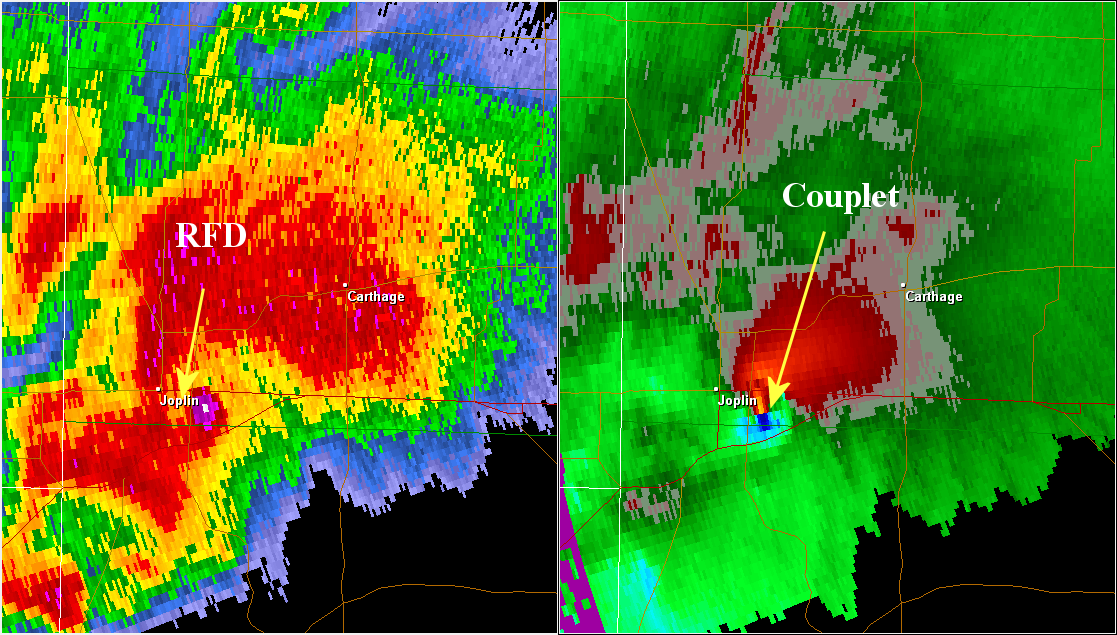
Heimaey as a classic supercell, or slightly HP, with a nice RFD curling around. Stórhöfði at the southern tip of Heimaey as a newly developing cell at the flanking line of the dominant tornadic Heimaey supercell within the Vestmannaeyjar archipelago.
The southernmost multicell at the convective Vestmannaeyjar archipelago, called Surtsey, as the Tail End Charley of this system is developing into a supercell. The whole Vestmannaeyjar archipelago seen as a convective system with discrete thunderstorms along a boundary like a trough, dry line, cold front or an outflow boundary.
Things are looking a bit interesting for team Hekla:
19.09.2018 10:58:40 63.917 -19.724 2.5 km 0.5 63.38 3.7 km W of Vatnafjöll
19.09.2018 09:41:44 63.922 -19.672 1.3 km 0.3 99.0 1.2 km WNW of Vatnafjöll
18.09.2018 23:20:52 63.993 -19.693 0.5 km 0.5 99.0 1.2 km W of Hekla
18.09.2018 08:07:05 63.985 -19.546 13.2 km 0.7 99.0 6.0 km E of Hekla
After manual revision, the last one (first in the list) was changed to magnitude 1.0 and depth 3.1km.
Surtsey and Heimaey was two quite diffrent eruptions. Surtsey was more fluid than Heimaey.
Heimaey involved old cool basaltic lava that been sitting in a chamber, it emerged quite viscous and produced a generaly Etna – Stromboli looking viscosity, with tall ashy lava fountains and huge spiney Aa flows that crushed everything in their path. These basalt flows was massive one of the thickest basalt flows seen in action.
Surtsey was fluid and almost hawaiian in viscosity.
After the wet Surtseyan phase, very fluid lavas emerged from Surtur vents. All fluid pahoehoe and lava tubes. A lava lake formed, later overflows perched that lava lake in a spatter cone. The Surtsey lava lake was active for 13 months. The lava lake supplyed tube systems and feed the growing lava deltas.
On the previous post, Turtle wrote
Coincidently there also happens to be a very big LERZ flow around the same time the last caldera formed in the late 18th century, and another around 1500. Also ‘just by coincidence’ each of these eruptions occurs some short distance in time after a lava shield formed on the rift zone. Two of these shields even happened in basically the same spot, and 3 such shields were formed between 1986 and 2018.
The link between a shield eruption, a LERZ flow and a caldera collapse is worth looking at. The first question is whether there are counter examples: were there shield eruption that did not give LERZ flows and cadera collapse events?
The other point that was raised was why the shield eruption had no effect on the caldera, but the LERZ event gave an immediate collapse. The shield happens when the caldera magma is in equilibrium between pressure from below and the exit hole. The LERZ is driven purely by pressure from main magma chamber. Why – that remains to be answered
Probably a good place to look is “Caldera formation by magma withdrawal from a reservoir beneath a volcanic edifice” Pinel et al (2004) {Paywalled at that link but there may be other sources if you look hard enough}
From that, the deciding forces are going to be the depth of the chamber, resiliency of the overburden, and the mass of the edifice.
I think the way it goes is that after a collapse, there is a deep caldera which fills up rapidly and flank activity is minor. After 1790 there was only small eruptions on the flank and all of those were on the southwest rift, most of the lava erupted in the caldera. It wasnt until the caldera mostly filled a few decades later that bigger flank eruptions happened, first in 1823 then a very big one in 1840. The same thing almost happened again in 1924 but unlike in 1840 kilauea had a low magma supply so 1924 was small and never erupted.
In 1952 things started increasing again and because the summit was mostly filled things went into the rift almost immediately and after a while there was a stable enough conduit that it was easier for lava to erupt continuously there than at the summit. That is what happened in 1983, but eruptions happened in the same area throughout most of the 1960s as well as 1977 so this shouldn’t have been surprising. Eventually the pressure grows too much and the rift opens all the way to the LERZ, and this is what happened this year. I somewhat disagree with the papers saying the LERZ is usually way more active than it is now, especially because their so-called high activity time actually occurs simultaneous with the aila’au eruption and that doesnt really make much sense. More likely is that eruptions there are generally very big and happen along large fissures with many flows that dont make contact with each other and so appear separate. The 1790 event would appear to be anywhere between 2 and 6 separate eruptions if it wasnt well exposed and relatively recent.
There is one notable difference between this eruptive episode and the previous one though, the volume. Most of the eruption volume comes from the shield eruption/eruptions, followed by the terminator event at the end. Heiheiahulu is about the same size as mauna ulu, and assuming about 15 m3/s average effusion rate of mauna ulu for the roughly 3 total years there was continuous effusion there and you get a volume of about 1.4 km³. Heiheiahulu is probably therefor somewhere between 1 and 3 km³ in volume. The 1790 rift eruption if it has an average flow depth of 10 meters has a volume of about 0.4 km³. This is likely an underestimate but it is still less than 1 km³. The only other large eruption from about that time seems to have been from kapoho crater (which produced no large lava flows) and pu’u honuaula which was about maybe 0.2 km³ total or similar to 1960. In total that eruptive episode is about maybe 5 km³, and being generous and assuming caldera filling comparable to post 1790 brings the total volume up to about 9 km³. In contrast this eruptive episode produced about 6 km³ of lava between 1790 and 1924, 3 km³ of lava between 1952 and 1983, and a whopping 12 km³ of lava between 1983 and 2018 from pu’u o’o and 1.2 km³ from the leilani eruption… 9 km³ vs 22 km³… I am likely missing a lot from the pre-1790 period but even still it is pretty unlikely that it is anywhere close. it is also interesting that this episode produced the biggest volume of lava but made the smallest caldera, maybe this will be a transition to another summit overflow period. If the same sort of thing happens to this caldera as what happened after 1790 then it will take only a few years to fill the entire caldera to overflowing.
There is also the interesting tectonics to the south of the caldera that is entirely less than 600 years old, currently it is non-eruptive but that area wasn’t there last time there was a large scale summit overflow so it could be a major wild card and a significant part of it does seem to be underlain by magma. Eruptions on the seismic SWRZ can be very vigorous, only one has happened in recent history but it had a peak eruption rate that dwarfs anything else in Hawaii and almost compares to a mini flood basalt, that happened overnight on December 31 1974, the peak eruption rate was in excess of 700 m³/s and with a peak probably around 3 times that, higher even than the high fountaining episodes of several other recent eruptions. It also happened less than 7 hours after any warning signs, that could give hekla a run for the money. The lava from that eruption was erupted so fast that it actually did most of its flowing after the eruption already ended…
Side question…..
Why is the year 1790 so firmly set as THE date of the eruption?
It is written about pretty much everywhere as an absolute fact.
How is it that this one year so firmly set when so much of the rest of the history of Kilauea before 1840 is not?
The first westerners arrived to Kilauea in 1823 (at least Ellis did), not 1840 so it is actually from 1823 from where we more or less have a good descrition of the events happening. About the eruption of 1790 (I am referring to the effusive one in the LERZ) it is not an absolute fact that it happened that exact year but even if it didn’t there is enough evidence to say it happened very close to it. The 1790 AD date is testimonial, it was told from the natives to William Ellis during his trip through Kilauea. I know that hawaiian oral history is usually not taken very seriously, but I was just reading part of Holcomb’s “Eruptive history and long-term behaviour of Kilauea volcano” from 1980 (I think) and realized how many things the oral history was right about and that at that time were put in doubt because geologic evidence didn’t support it. For example the gradual developement of the caldera and multiple explosive eruptions (In 1980 it was thought the caldera and the Keanakakoi tephra had fully formed in 1790), that there had been multiple flank eruptions appart of Keaiwa after 1790 (recently discovered that the Kealaalea, Black Cone and Kamakaia eruptions on the Seismic SRWZ do postdate 1790) and that the most recent summit overflows had happened many king’s reigns past, so presumably a few centuries ago (In 1980 the summit overflows were thought to have extended into the 17th century, but now after dating the 1500 reticulite it is known that the summit overflows must predate the reticulite). It turns out the formerly thought to be unrealiable oral history was actually right about a lot of things. I find then interesting more of what was told to William Ellis in his trip including the one that a vent erupted large amounts of lava during Liloa’s reign (thought to have been around 1475) in the upper ERZ, the most likely candidate is Puu Huluhulu, a sustained shield-building eruption. This would be interesting for the relationship between large ERZ eruptions and caldera collapse events we have been discussing about because there was a caldera formation event around 1500 and maybe others not very long afterwards and there are two dated flows in the LERZ (a shield, and an extensive flow) also around that date, in that case comprising what would have been a phase of ERZ activity followed by caldera collapses and explosive events. There would need to be more evidence for Puu Huluhulu having formed then of course, there is not, but there is for 1790 having really formed around 1790 as I mentioned at the beginning. The two flows atributted to that date are dated in less than 200 ya BP and this supports it very well, there is also the very obvious evidence that especially when looking at old aerial images the vegetation of those flows is very very young and same goes for a couple of other ERZ eruptions some of which are also dated in <200 BP including the sustained eruption vent of Heiheiahulu. 1790 was then very likely the cause of the caldera collapse (and maybe the formation of 4-5 ERZ pit craters) that also has a similar age and triggered the 1790 summit explosive event, the few decades preceding 1790 were also probably dominated by a phase of ERZ activity similar to the current one starting in 1960, the years before 1790 also included an eruption similar to Pu'u'o'o (Heiheiahulu), this is the reason why turtle and I were usually comparing this years eruption to 1790, because the system was in a similar situation, in the end some important differences have showed up.
The southern part of the caldera is indeed really interesting, contrasting with the northern part that has been inactive for some time, the southern part contains the one thought to be the larger magma reservoir of Kilauea under the south caldera rim, and that is still down there having survived this year's collapse. The Seismic SRWZ and ERZ start from that southern part and cannot be explained by simple dike intrusions, the conduits have to be more complex and maybe include some smaller magma reservoirs, as evidenciated by Keanakakoi and Kilauea Iki pit craters magma reservoirs have formed near the caldera complex in the past. The south caldera area also experiences volcanic activity, most fissures open through faults that roughly have a N 80º E orientation, similar to that of ERZ fissures and Koae and Hilina faults. This probably means the south caldera is under gravity-driven spreading associated to the Hilina Slump. The new collapse crater probably has probably been influenced by this "weak kine" judging from how the newly formed south rim is an oddly straight line. There are other eruptions, just two (1877, august 1971), that have erupted through the southeastern caldera rim fault, while other eruptions from ring faults are very rare in Kilauea. 1877 in fact erupted lava into both Kilauea Iki and Keanakakoi craters which also makes wonder about the interaction between Kilauea Iki and the southern caldera reservoir, also with the rift zones.
In the deciding forces over ERZ intrusions and summit collapses the active spreading of the east rift should be considered because it would lead to a low confining pressure which would allow more long-lived stable dikes that would need for the magma body to depressurize more than usual before the dike shuts. The south flank is very actively sliding towards the ocean and clearly detached, in fact I don't think there is any other oceanic island volcano outside Big Island that can match Kilauea in this aspect. The big island has produced several magnitude 6 and 7 earthquakes and also the 7.9 Ka u earthquake, some of them are from Mauna Loa, others from Kilauea, Ka u probably shared. To see how intense this spreading is, the 1924 LERZ intrusion caused an area 6.5 km long per 1.5 km wide to drop up to 3.7 m, a large part of the east rift is a graben that has sunked a few meters except the areas very recently buried by lava. Being in such an active spreding area probably lowers the confining pressure considerably and might explain some of the behaviour of the rift zone like sustained vents that erupt continuously for decades and I dont think happens in other basaltic shield volcanoes. Sometimes it is like if the rift imitates the summit for a certain period transforming into the location of continuous activity and holding its own magma reservoirs, the ERZ very probably has the capacity to hold more magma at a certain moment (I estimate 0.4 km³ for the times of Kane Nui o Hamo) than Piton de la Fournaise shallow reservoir (0.35 km³).
I don’t know how fine the resolution is, but there is a blip in the SO2 levels at 1783 for the Greenland ice core series (Northern Hemisphere), Nothing shows up in the Taylor dome series for this time. (Southern Hemisphere) {Inverted in this plot for readability}
That in interesting and all makes sense.
I have now also found and read Donald Swanson’s paper on reporting and interpretation of the Hawaii oral tradition.
Hawaiian oral tradition describes 400 years of volcanic activity at Kīlauea
DA SWANSON – Journal of volcanology and geothermal research, 2008 – Elsevier
I have no doubt that an explosion occurred on or around 1790. I’m just not as convinced that this was the one singular significant geologic event up there at the summit that it appears to be very often getting credit for.
I am now also diving into some more research on the Keanakakoi ash.
https://volcanoes.usgs.gov/observatories/hvo/hvo_volcano_watch.html
Todays volcano watch article, there is some stuff on the size of the caldera. However the idea of extended effusive eruptions causing caldera collapses is still being shown. Also I dont really know what they use to determine volume of eruptions but it is pretty decidedly wrong when you compare the volume estimated for pu’u o’o (4.6 km3) vs the volume you get by taking its average eruption rate with its duration (12 km3). In this case most of that difference must be in the ocean.
Aila’au lasted for roughly 60 years, and its lava flowed about twice as far as the June 27 flow did in 2014. June 27 flow had a flow rate of about 6 m3/s. Aila’au therefor must have had a flow rate of about 10-12 m3/s to form tube fed flows to the ocean over that distance. 10 m3/s is about the same as the eruption average of pu’u o’o before 2007, and because that eruption went for 60 years, about twice that of pu’u o’o, gives a volume of about 24 km3. The observatory shield is much bigger than either eruption again, and its flows reached similar distances as the aila’au eruption, so assuming it erupted at comparable rates for the 200 years or so that it was forming it could have a volume of as much as 150 km3.
I dont really know how these volume measurements are so different to HVOs numbers. Pu’u o’o maybe wasn’t erupting at a standard rate for about a year out of 30, so I dont think that quite covers the gap…
150 km³ would be like 10 lakis, I really doubt the Big Island has ever come close to that number in 200 years.
If there is a well studied prehistoric Kilauea eruption that is Aila’au: https://link.springer.com/content/pdf/10.1007%2Fs004450050279.pdf
The estimated volume of Aila’au is of 6.5 km³ in the link you can see the method they used, first they made sure there was no volume lost to the ocean and since there it was not possible there to be any delta collapses and only a very few and small flows made it underwater then all the volume is subaerial. They also used thickness higher than that of Pu’u’o’o average due to the gentle slopes and also a very well studied surface extension. Aila’au also as far as is known may have lasted 60 years, 30 or 200. The 60 years duration comes from the assumption that Aila’au had a similar rate to Pu’u’o’o of 0.1 km³/ya and that is something we simply don’t know, I don’t understand why HVO is using the 60 years duration as a fact. The actual average summit rate observed from 1840 to 1924 is of around 0.05 km³/ya or less, and that would be what I would expect for Aila’au. The higher rates of 1790-1840 were probably at least in part due to rebound from the large 1790 collapse and from smaller collapses in 1823 and 1832. The last large Kilauea collapse had happened several centuries before Aila’au. It is very likely that the 1790-1840 high rates were also due to the summit not having to compete with the ERZ so it could be debatable that during Aila’au the ERZ was completely shut but Aila’au likely being the last summit overflows means the transition to ERZ activity might had already started by then. I dont think the Observatory flows are substantially more voluminous than Aila’au, at least the surface extension is similar. The Kalue flows do look really extensive, probably more than the other two, the radiocarbon dates indicate a possible start of eruptions arund 1000 AD and the last flows in 1300 AD, one thing is sure, between the last Kulanaokuaiki explosive events around 800 AD to the collapse of around year 1500 it was the time frame when the existing caldera must have filled and the Kalue, Observatory and Aila’au flows erupted, it might have been the result of long lived low activity more than intense activity during a short period. The subaerial extension covered by ERZ lavas is more or less the same when compared to the extension covered by summit and SWRZ lavas, Mauna Ulu is practically as tall as the summit and the summit area is built on Mauna Loa slopes, if we add the 70 km long Puna Ridge to the ERZ then it becomes obvious that the ERZ is more productive than the summit and SRWZ together, and yet most of the last milennium has been occupied by summit activity with the ERZ barely erupting for less than three centuries (I think would be safe to say), this should mean that the ERZ has higher average eruption rates than summit activity.
Funny thing that I don’t agree with almost anything about the interpretation the article gives about Kilauea’s history and yet I agree with their conclusion. So, they say there were centuries following collapse events where the supply was very low and only a few flows erupted from one of the rift zones (let me guess, the ERZ), now the research about Kilauea’s cycles used 94 dated flows, but only around 8 were from ERZ lavas. I think the others can be assumed to be from summit overflows and maybe 1 or 2 from the SRWZ which has historically erupted an insignificant amount of lava compared to the other two. Then, if a few flows erupted from the ERZ during those centuries following collapses doesnt that mean almost all of the 8 dated and used ERZ flows and then presumably the ERZ itself erupts during those centuries of said low effusive activity. The problem is that HVO doesn’t seem to realize that ERZ and summit alternate in activity which is something quite clear during historic times, and I think it what used to be thought before this theory of low effusion periods sprung up. But I do arrive to the same conclusion through the way I think Kilauea’s cycles work that new summit collapses are coming soon (a few decades) and probably trigger some explosive activity.
As far as Hawai‘i capability overall, something like 150 km³ in 200 years might even not make Mauna Loa’s “Top 100 List” of 200 year eruption totals. Obviously, ML is a different scale of beast compared to anything else that has ever come before.
Thus, I tend to agree WRT Kilauea specifically. Based on what it currently is and what it has been so far, that level seems like it would be a pretty high bar. Still, even if Kilauea’s output potential is “only” a quarter of that (which may be well with in Kilauea’s current bandwidth), 2.5 “Lakis” in 200 years is still quite a lot.
Not all of the observatory shield formed in that 200 year period either, it just made the maths easier and I forgot to say… But it doesn’t make a huge difference still.
The summit overflows travelled a long distance, much further than the 2014 flow, and anyone that has been to nahuku (or at least seen it) can see that the lava tubes from these eruptions are huge, so the eruption rates must have been higher at least part of the time and also sustained at that value for long enough to form the flow, probably at least 2 years for the biggest ones. The volume of the observatory shield is definitely way higher than for aila’au because it also had to fill a caldera that was probably about twice the size of the current one at least. I don’t know much about the kalue flows but from what I have seen on a geo map they very probably erupted at the same vent complex as the observatory flows, just with some barrier that separates the two (possible small collapse and flank eruption?) so I count the volume needed to fill the powers caldera as part of the observatory shield and that shield as a big compound structure. There was a picture of the exposed strata in the side of halemaumau that actually shows what is probably the thickness of the observatory shield at that location in its entirety, and the shield is over 100 meters thick at that point. Given that the vents were formed in a caldera and also several km distant to that location you can see how big this volcano was…
Also the 1790-1840 high rate was in part from the reasons you mentioned but pu’u o’o had a similar rate of effusion until about a decade ago and that was entirely mantle driven. Heiheiahulu was much smaller than pu’u o’o but still very sizable and must have been formed under similar conditions. Thus the eruption rate was most likely already fairly high before the collapse and thus explains why major eruptions occurred only a year or less after the collapse. Given that the collapses don’t destroy the magma supply at depth there is no reason to think the base supply that was feeding pu’u o’o has actually changed so reactivation should be similarly swift and probably just as violent.
It seems we disagree on the eventual outcome though, you think there will be more collapse events this century and a bigger caldera, while I think the summit could well overflow in the same time period. I guess unless you are really old we will just have to wait and see.
Also mauna loa might be the biggest volcano in Hawaii now and much bigger than its predecessors, but kilauea is fast on its tail. Kilauea is the same volume as mauna kea but without even going through its biggest growth stage yet. I think kilauea might also be the biggest volcano for the age it currently is, although it’s hard to test that exactly. Still, kilauea is maybe half a million years old at most and it might be only half that age, and in that time it has erupted 40000-50000 km3 of lava. That gives an average rate of between 0.1 and 0.2 km3 a year, and when it reaches its peak it will be more than double that rate. I recall you had some research on mauna loa that was on this subject, I’m interested in seeing it as that could give a lot of information.
Even disregarding all the other points, it is pretty obvious that the currently active islands are much bigger than the older islands and seamounts all the way up to the detroit seamount, which has been studied and was formed over a much longer time period than the big island. Hawaii seems to be experiencing a long term major hotspot surge, the big island and maui nui combined contain about 70% of the entire exposed history of the hotspot, 600,000 km3 in about 2 million years, about 3 times bigger than the Columbia river basalts in less total time. That has to count for something.
The Kalue flows and Observatory flows might be basically the same, with no known summit collapse between them. The last of the Kulanaokuaiki tephra explosive eruptions hapened around 800 AD, so igt was also the last time the Powers Caldera reached the water table, from there to the first overflows of Kalue around 1000 AD it would have been caldera filling. From 1000 to 1450, the aproximate date when Aila’au formed, it would have been continuous summit activity. The caldera filling, Kalue, the Observatory shield and Aila’au could be put under the same eruption cause as far as we know there was no interruption. In that case it would have been almost 700 years of more or less continuous summit eruption. The volume erupted during than period is very difficult to estimate, Aila’au was 6.5 km³, but the Observatory flows as far as I know are not well mapped (I would say they are similar to Aila’au in volume), the Kalue flows are partially buried by Aila’au and the Observatory flows and it would be nearly impossible if not impossible to estimate the size the Powers Caldera had when filling started. I would like to say though I dont think it is likely that the combined volume is of more than 50 km³ but there are a lot of uncertainties.
I am still young so I hope to be around to see what Kilauea does throughout most of this century. The best publication I have ever found about the eruptive history of Mauna Loa would be this: https://www.researchgate.net/publication/262223101_Holocene_eruptive_history_of_Mauna_Loa_Volcano_Hawaii
Kane nui o hamo also happened in that time period, it created the pu’u loa petroglyphs lava flow which has apparently been dated to the 1300s era. If you look at the lava it doesn’t look like it is that old either. This eruption could have been a gap in the summit activity, and it is possible that there was a simultaneous eruption on the summit and rift like there was recently. That will never be known for sure but it doesn’t seem unlikely.
This also brings up the interesting situation where the summit overflows continued after a large rift eruption, and from what the more recent activity is that kane nui o hamo was very likely terminated by a LERZ eruption, but one that didn’t cause a caldera event.
Maybe the current caldera is actually fairly standard, the 1790 caldera isn’t much bigger and it would only take maybe a few years to fill a pit like this one at full rate. The 1500s collapse was possibly a much more deep set and damaging intrusion, the lava on the east rift from that time period is picritic compared to the primitive tholeiite? of this year and 1790 and that indicates a much deeper and larger intrusion that was never at the summit as well as a terminator event that caused a draining of the upper system. In 1500 the caldera collapsed out almost as far out as the flank of mauna loa in the north direction and included subsidence of the entire koae fault and upper east rift, as well as more obvious collapse of the observatory shield and formation of kilauea iki and probably also napau and makaopuhi craters. This eruption could have been huge, most of the lava is underneath pu’u honuaula and now also pu’u 8 so it’s total extent will never be known but it was probably at least comparable to this year. I hypothesised that halekamahina cone could have also formed in this eruption too if it is picritic.
The recent collapse tended to follow existing faults, so the total extent of collapse in 1500 might have been bounded by the extent of the powers caldera faults. The amount of time the powers caldera was there was a lot longer than the age of the current caldera (~1000 years vs 500 years) as well as the amount of tephra erupted indicating a significant amount of time the caldera was below the water table, to me this indicates the caldera was very likely a lot bigger than the current one, probably also located more north so the observatory vent happened on its more southern side. A lot of the explosive eruptions from that time but especially the 800 AD event have been studied and found to be completely magmatic, and not only that but also some of the most primitive basalt ever found, bordering on being ultramafic (something like ~46% SiO2 18% Mg) so the entire thing would have rise up from the mantle and erupted almost immediately, the speed of the magma causing it to contain all its volatiles until it bears the surface, very similar to the tarawera eruption, and also grimsvotn 2011. Technically this sort of eruption could occur at any time, if magma rises from depth and misses the chamber it could erupt this way outside of deep caldera phases. 1959 might have been an example of this but which didn’t become explosive.
This event actually happening means the shallow magma chamber probably wasn’t actually a thing at this time and that probably means the caldera was wider than the current one anyway through caldera wall instability and collapses.
The petroglyphs dated in 1300 AD just means Kane Nui o Hamo must be older than that, it just gives the minimum age not the maximum. The flows of Kane Nui o Hamo do not look recent at all.
That is an old aerial photograph that comes from here: https://guides.library.manoa.hawaii.edu/c.php?g=704385&p=5001010
It shows the contact which is more or less along the middle between Aila’au/Puu Huluhulu flows to the left and Kane Nui o Hamo flows to the right. You can see that in the coastal area to the right no flow lobes are distinguishable and there seems to be more abundant vegetation. I interpret this as there being an important time gap between the emplacement of Aila’au/Puu Huluhulu flows and the Kane Nui o Hamo flows.
I think it would also make much sense if Kane Nui O Hamo formed in a period of no summit overflows and known existence of a summit caldera (recently seen that ERZ activity can cause summit collapses) as it was the Kulanaokuaiki tephra period, maybe towards the end? So around 800 AD. If Kane Nui O Hamo terminated with a LERZ eruption then it might have been Puu Kaliu as there also seems to have been a considerable time gap between it and the eruptions of ~1500 (a few flows between Kaliu and 490 BP and 440 BP). But as you well said right know there is no way to know for sure since none of the two is dated.
About the posibility of Kane Nui O Hamo being 1200 years old I would also like to point out that it might have been the first Pu’u’o’o like eruption of the ERZ. Kane Nui O Hamo is still a very prominent cone, rises ~100 m from the areas downrift and uprift which means these structures take a very long time to be covered and yet there is no older than Kane Nui O Hamo shield structure in the ERZ. The only way I think a shield of an original height of more than 100 m that formed in the last few thosand years might have been completely buried by 1960 is if Kane Nui O Hamo had erupted right on top of it.
I usually place the formation of Makaopuhi much before 1500 because in the Makaopuhi deep pit walls there were represented multiple filling events in the bigger pit paleo-lava lake, five different flows that precede 1840. And that was just the exposed part, it can be assumed that there are more underneath that the west pit didn’t reach deep enough to expose. About Napau I dont know, it is in a very advanced state of filling, more than Makaopuhi but it might have taken a very big hit with the 1840 eruption that had one of its main vents near it, and there were also many vents of the years shortly before 1790 close to it so I can not tell for sure if ~1500 or older. There are several craters, Hiiaka, Aloi, the big Pauahi pit, the big Alae pit and maybe Keanakakoi, that before 1960 had a small cover of probably just of 18th century eruptions (except for Keanakakoi) so are good candidates to have formed around 1500.
Interesting picture. It does look like there are some visible flows in the middle though, they dont look like they are part of either flow actually.
Also what is your source for pu’u huluhulu being a sustained shield eruption? Mauna ulu is definitely one of those, it is literally shield shaped, however pu’u huluhulu is a cinder cone, not a lava shield, and if it was sustained it would probably be disrupted the same way pu’u o’o was over time. There might have been another eruption in the area that had its structure destroyed by a pit crater. I guess we will never know for sure now though with that area buried.
If a big flank eruption happened at that time though, then that is an interesting parallel with the last 60 years. First you had the pu’u huluhulu eruption which probably happened soon after the end of the aila’au eruption or maybe was simultaneous with it, and then maybe shortly afterwards was the eruption lower on the rift that formed the 1500s shield and then the large terminator event occurred that lead to collapse of most of the summit.
This cycle there was mauna ulu, then pu’u o’o, and now the leilani eruption. The only difference is that while a lot of the summit experienced some subsidence only a small part of it actually collapsed compared to 1500, so there could be more coming and maybe these large events take several collapses to reach full size. At least the upper rift and koae fault probably still contain a lot of magma and still be capable of draining out. If your calculation is correct and there is about 0.4 km3 of magma in the rift, and the rift hasn’t deflated much except at pu’u o’o so it is reasonable to assume most of that is still there. All it would take is for the rift to receive new magma and it might just build up over the next few years and then surge down the dike that fed this years eruption and erupt near the end of it sort of like 1960 after 1955. I dont think this would do much to halemaumau but it could cause large collapses to the south caldera and upper rift where there is still magma. That actually might divert eruptions to that area afterwards and be a part of the gradual southward trending of the main eruption center that we talked about a while ago.
Here is an [animated] gif I made of my idea.
I dont know if it is easy to see but my new hypothesis is that the rift might get drained out but in another separate eruption that occurs at the end of the previous dike. I dont necessarily think it will actually happen next year but it could, and with the way the rift is apparently inflating again (mostly near pu’u o’o) there is a high chance of something like this happening soon. In this case it probably wont be anywhere near as big as this years record eruption, and also likely wont cause any extra damage, nearly all the property that was there has already been destroyed by this years flow, but this event could still be a very big eruption in its own right (bigger than 1955 or 1960) and have profound effects on the national park, namely by leading to new pits or expansion of existing ones, as well as a likely continued summit collapse, this time not centered at halemaumau but rather on the south caldera and keanakako’i, and possibly kilauea iki if that is connected too.
The gif isnt really to scale either, its just there to show my idea better.
https://giphy.com/gifs/1zhIca10vIhU1XqcHf/html5
(actually here, can someone replace it please)
GL Edit: Best I can do at the moment.
I think it possible that the majority of the Aila’au flow field was built in far less than 60 years.
For lava to have traveled that distance and covered that vast area of the east flank of Kilauea over a relatively gentle slope, the magma must have primarily been erupted as Pāhoehoe rather than ʻAʻā.
Pāhoehoe would not have taken take 60 years to move down the hill and spread out. ʻAʻā probably wouldn’t have moved that far from the source over any period of time. We have a very recent example on a much smaller scale with F8 in the LERZ.
Based on what happened recently to Kapoho my guess is it is possible that the eruption rates that created the Aila’au flow field were much higher and thus it took much less time.
One of the vents of Puu Huluhulu has the obvious morphology of a cinder cone, but just northeast of the prominent cone there is another vent that is more broad an a little more shield-like. The main cone of Puu Huluhulu also has only a cinder cone morphology on its peak and it is the tip of a small shield structure. I think that its flow field is also predominantly pahoehoe so likely formed from a slow eruption. Holcomb did consider Puu Huluhulu as a sustained eruption in his publication about Kilauea’s eruptive history but also did the same with Kokoolau and I think that with Kalalua too. There really are only three large shields in the ERZ that are taller than 100 m and have large pit-like craters on their summits: Kane Nui O Hamo, Mauna Ulu and Pu’u’o’o. There have been other rift eruptions that more or less resemble the larger shields and probably had a similar eruption-style at least at some point, of those Heiheiahulu is probably the one that better resembles the Pu’u’o’o-like shield. There is also the Ponohohoa Chasms and Mauna Iki shields in the volcanic SWRZ but that while they may have had relatively extensive flow fields are not topographically prominent, and while this may be to blame from more fluid lavas the volumes are probably very small compared to the mentioned ERZ eruptions.
If an ERZ shield had been swallowed by a pit crater it should be represented on its walls. The walls of at least some of the craters have been studied.
About the near future of Kilauea I am still considering several options. I would predict that by the end of this century another eruption or eruptions will have happened in the LERZ, that if being onshore (the most likely case) has the potential of being quite damaging. One of this eruptions will end up causing a summit collapse either similar in size or larger than this year’s (probably larger) and will also trigger the formation of likely 3-7 pit craters in the upper ERZ. The summit caldera will very likely reach the water table and cause an episode of explosive events and high fountaining. By the end of the century caldera filling will very likely have resumed already. I base this in that I don’t think the east rift zone has drained and closed as this would have been accompained by collapse of upper rift reservoirs and pit crater formation, which hasn’t happened. There has also been some significant deformation picked up by the JOKA GPS of the Heiheiahulu area that has been inflationary more or less since middle august and a couple of days ago switched back to deflation. I am not completely sure of how to intepret this but I think the most likely cause is that some magma has intruded the uppermost LERZ recently and then partially drained away (drained downrift?). If a similar deformation behaviour continues like this for some time then it would likely mean magma is being transferred into the LERZ from uprift but it is still too soon to tell. While I think that a new summit collapse and the associated events will have happened before the century closes what happens in the meantime is more unclear. The rift zone could reactivate right away or the summit might need to first reinflate before sending magma into the rift, this means lava may first come out of the summit, maybe from the recently heavily fractured south caldera area and also maybe in the form of high fountains. How the rift will ramp up to triggering the next collapse event is someting I have been wondering about, I guess you say that it will go straight into another voluminous LERZ eruption which I guess it is a posibility, but there could also be a third sustained eruption in the current row and most likely around Heiheiahulu or in the Leilani area. Or the ERZ could enter a period of short small eruptions like 1961-1969.
Pahoehoe is usually emplaced during low rate eruptions, lower rates than that of aa flows. Pahoehoe flows are also more slow moving, in fact an aa flow is basically what happens when these flows advance fast enough either because of high rates or steep slopes. The flow field wasn’t generated in one single event either, there was probably a constant activity at the Aila’au shield that at some point would overflow down the slopes and not always reach the sea, if you look at the distribution of the AIla’au flows the only wide and probably sustained ocean entry was around Kaloli Point which is probably a lava delta that was fed by the Kazumura lava tube if I am not wrong it is the longest lava tube of the island, but since I am not sure I will say the longest lava tube of the Aila’au flow field. Most flows didn’t made it to the ocean or barely made it.
Oops….I clearly got my Pāhoehoe and ʻAʻā backwards. I hate it when that happens.
My poorly argued point was a guess that that there is at least a possibility that the Aila’au flow field was created by a much bigger version of something like what we just witnessed and that is possible that it may have taken less than 60 years.
Well, I am more of the idea that Aila’au took a little more than 100 years to form xd.
The flow field is predominantly pahoehoe so it has to be a rate much lower than the one observed this year or it would turn into aa as it happened in Leilani. Also it is generally accepted that Aila’au was a summit eruption and the summit has been erupting at rates of around 0.05 km³/year or less throughout most of historical times which is lower than the ones of Pu’u’o’o or Mauna Ulu. I have read interpretations that this difference may be caused by rift zone activity pulling more magma from the conduit and raising supply rates because it tends to cause summit deflation more often appart from maybe being an easier path for magma getting out. The summit did had really high rates during 1823-1840 and presumably also during 1790-1823, but this was probably a rebound from collapse events as the peak rates were observed after small summit collapses and probably all the period was still influenced by the high supply Kilauea probably had by 1790 due to ERZ activity and the added boost of a caldera forming that year. The summit rate drastically dropped in 1840 from the 0.1-0.33 km³/year to around or less than 0.05 km³/year.
OK, at the current moment, my revised personal idea for Aila’au is a compromise.
A possible initial higher flow ʻAʻā lava period in the mid 1400’s similar to F8 but possibly just a little longer in duration followed by an extended Pāhoehoe lava period probably lasting decades.
The general summit area was obviously the source but it looked much different back then.
I would expect that the upper ERZ shields, like Pu’u O’o, have vents gravitationally above the magma chamber. They therefore act like overflow vents the same as the overlook crater did, and erupt only at Kilauea’s supply rate. But once a dike to the LERZ forms and erupts, this vent is gravitationally below at least part of the magma chamber, and the conduit from the magma chamber to this vent behaves like a siphon. As long as the lower end of the siphon is below the level of the fluid in the chamber, the siphon continues to suck out fluid and the LERZ eruption continues, while the magma level drops and a collapse caldera develops above it. Once the magma level is down to the vent height (which meanwhile is increasing due to cone building) the eruption halts.
For that eruptive phase to be permanently over, though, the dike has to age enough to solidify. If a bolus of fresh magma arrives from depth sooner, it will push magma into the dike and that will feed fresh eruptive activity at the LERZ. The same if magma finds a new route to a low enough vent in the LERZ. Something like this might have triggered the second 1790 fissure.
Once the dike solidifies enough, further eruptions will be in the summit/SWRZ area for a while.
For all. Editing tip for exponents. (no, it’s not required, but it makes getting your meaning across a bit easier) ♫
[alt] 0179 on the numeric keypad makes a ³.
(0178 for ²)
You can do this on the fly as you are typing your comments.
I always liked the old ASCII characters. Another useful one (especially when discussing magma/lava temperatures is [alt] 248 for the degree symbol °. °C, °F.
For those of us with no numlock key, open the on-screen keyboard by right-clicking start and search for it. Press options then tick the “enable numeric keypad” option. Now you press the numlock button and then do the [alt] [code]. (Not very convenient!)
or run charmap and click then copy and paste 🙂 °¹²³ʰʲʷʳʸ˟ˢ͓̽̾̾ͩͩͣͤͦ
Although many of you would never dare to visit this website…….
https://wattsupwiththat.com/2018/09/20/icelands-monster-volcano-charging-up-for-eruption/
The Katla volcano, hidden beneath the ice cap of Mýrdalsjökull glacier in Iceland, has historically erupted violently once every 40-80 years. In-as-much as it’s last such eruption took place one hundred years ago, in 1918, Katla’s next eruption is long overdue.
I have included this link so you will not have to go to WUWT
https://icelandmag.is/article/new-study-confirms-monster-volcano-katla-charging-eruption
It mentions the word “overdue”, therefore ignore it entirely! Not exactly new news anyway, it has been slowly building up since 1999, and particularly since 2011. But it has gone quiet again for now, so no indication that an eruption is near.
I agree on the term “overdue” with regards to the geophysical. I was particularly amused by the media convention that Eyjafjallajökull was always accompanied by Katla. The statistical relationship is the rough equivalent to making a causal relationship between a bus stopping at the corner just because you happened to be there when it came by. Katla erupts so often that it is more rare for Eyjafjallajökull to erupt and not have Katla either in a direct run-up or having just finished an eruptive period. The statistical oddity is that Katla has not gone off yet. In previous Eyjafjallajökull events, Katla was within 5 years of activity.
Even with that, “overdue” is still a misplaced term. All volcanic processes are chaotic and don’t follow schedules.
For the alarmist bent… keep in mind that the tropopause is not very high at the latitude of Iceland. It does not take as much “oomph” to launch SO2 into the stratosphere here. (or at the Kamchatka peninsula) Plus the general atmospheric circulation here is upward between the Polar and Mid Latitude (“Ferrel“) cells.
“The Ferrel system acts as a heat pump with a coefficient of performance of 12.1, consuming kinetic energy from the Hadley and polar systems at an approximate rate of 275 terawatts”
She takes her time.
Good things take time.
Let’s hope that’s the reason why we still don’t know what the new Bronco will look like.
Erm, back to volcanoes. Well said concerning this “overdue” thing. Human weakness to differentiate the statistical image from the physical reality.
Welcome back GeoLoco, haven’t seen you for a while or have you been lurking?
I agree that it’s good to see him back on the board, but no, he is not me. That would be a ‘sock-puppet’ and the only alternate identity I use is from my phone as ‘Lurking’ when I don’t have access to my PC account. Typically, I fix my ident when I do get access later, but in all circumstances, I keep the same avatar on my comments.
i kinda assumed all the flying pigs were Yours…. it’s such a great avatar! Best! from motsfo in the cooling north….
Yeah… you are one of the only people to pick up on the “When pigs fly” connection. 😀
(it’s a probability thing)
Oh Diana will be pleased. Welcome back Loco. The Randy’s have been missing you
Nice to hear from you again, GeoLoco!
Hi all and thanks for so much warmth.
Look by from time to time. Just felt like dropping a comment as Katla seemed to be calling… 🙂
Still love to read you guys. Lots of interesting people in here.
And of course I’m not Geolurking in disguise or something. Nothing compares to this great mind. 😉
Drop by more often! always enjoy your posts..
I’ve been lax myself due to health and family issues..
@4EDouglas
Thanks.
Hope your health and family issues have come to a happy end. Or if not that this energy consuming phase of your life might soon be over.
Best thoughts and lots of strength.
If you read the abstract of the paper itself (https://agupubs.onlinelibrary.wiley.com/doi/10.1029/2018GL079096), the study is about something entirely different. Typical case of media outlets multiplying one terribly wrong article into sensationalist hype. Why, oh why can’t so many media outlets not hire at least ONE person who knows SOMETHING about science. That’s not difficult, I’m a historian myself, so no natural affinity to volcanology or any of the sciences, but paper abstracts aren’t THAT difficult to understand. Jeez…..sorry /end rant
End-Permian;
“…A vibrant marine ecosystem was continuing until the very end of Permian, and then bang — life disappears.
‘And the big outcome of this paper is that we don’t see early warning signals of the extinction. Everything happened geologically very fast.’…”
From Háskóli Íslands – Institute of Earth Sciences
“On Katla volcano and the flux of CO2
In an important newly published paper by Ilyinskaya et al. in Geophysical Research Letters the first estimates of the CO2 flux from Katla volcano are presented. These results have rightly received considerable interest in the scientific community. (The paper can be accessed here: https://agupubs.onlinelibrary.wiley.com/doi/abs/10.1029/2018GL079096). The main outcome is that the flux of CO2 from Katla is similar to 10,000-20,000 tons per day, a very high value that implies that Katla belongs to the group of volcanoes in the world that have the highest CO2 emissions.
There seems to be some misunderstanding in the media on the meaning of these important results. They should not be taken as a prediction of an eruption in Katla the near future. And they do not predict the size and magnitude of the next eruption. What this pioneering study shows is the large flux of CO2 and that this flux is observed in both 2016 and 2017. For how long this flux has persited is not known. It is possible that it has remained similar for decades. It is also unclear whether the CO2 flux observed has a direct link to a shallow magma chamber or whether there is any direct link with magma accumulation beneath Katla. It is possible that Katla acts as a conduit for gas release from magma at large depth beneath the Eastern Volcanic Zone.
The important and significant observations presented by Ilynskaya et al. demonstrate that we still have a great deal to learn about the volcanism in Iceland and the properties of individual volcanoes. The authors point out the need for more detailed observations. It is for example of major importance to know whether the CO2 flux varies seasonally. It is likely that more detailed measurements will provide important new information that can help in improving monitoring and hazard assessment. The results of more detailed measurements may also provide further constraints on the magma below the Katla volcano.
Magnús Tumi Guðmundsson”
Stunning video of flight over La Palma Volcano.
Really amazing, I love the Canary Islands and of all of them La Palma would be my favourite, I have been twice there, and also twice to the Teneguia and San Antonio cones the flight passes over. Beatiful in many different ways, particularly the Caldera de Taburiente is spectacular, it is also the most volcanically active of the islands in terms of number of eruptions.
Lovely! Thank you! It makes me think humans are like vegetation – opportunistically growing even in places that will likely destroy them!
Yes, the situation in La Palma is quite worrying. The village of Los Canarios remembers me of Leilani, constructed right on top of an active volcano rift zone. Even more worrying is that around 32000 people live in the valley of Aridane and it is a very real posibility a lava flow will head in that direction next time Cumbre Vieja volcano erupts, Involcan estimates a likelihood of 72% of an eruption happening in La Palma 100 years from now.
There is a lot of activity under all the Canary Islands at the moment especially Volcano Enmedio and around Teide.
La Palma and El Hierro have also been joining in.
http://www.ign.es/web/resources/volcanologia/tproximos/canarias.html
Thanks for alert! Interesting. Going to Tenerife this november and will be trekking around Teide.
I like the fact that Los Canarios have used the natural amphitheatre of a volcanic crater to house their sports stadium!
Beautiful!! Use to walk the “volcano ridge” from north to south once every november. One day walk over very exciting landscape with look down into numerous craters. Can be recomended for any volcanoholic!
Yes, la ruta de los volcanes (the route of volcanoes) a really unique place. I wish I could go there every year!
These Dickinsonia fossils discovered in Russia are about 20m years before the Cambrian explosion. Interestingly they have found the remains of cholesterol on the fossils which has helped to confirm they were indeed animals.
https://www.theguardian.com/science/2018/sep/20/558m-year-old-fossils-identified-as-oldest-known-animal
Well, in 1783 something might have happened in Iceland 😉
Now you’re just acting as his Laki.
That was meant as a comment on Lurking’s blip in the Greenland SO2 levels.
Right you are.
I’m starting to loose track of events I’m thinking about. (I think there is another “non clear” signal at 1190 bc that occur almost directly before the bronze age collapse.)
…so, with Laki and Hawaii both dancing about… how come only a single SO2 blip?
No, I’m not trying to equate 1177 bc with a volcano, but something got invaders and people in general, motivated into beating up on their neighbors and trashing civilizations.
The central idea is the all the disrupted people/invaders screwed up the trade networks and curtailed the easy production of bronze. Something had to start that. A drought at about this time usually noted as a motivator, but what I find interesting, is a spike in SO2 at about 1190 BC. I’m pretty sure it wasn’t noncompliant diesel vehicles. The Euro IV requirement of less than 50 ppm sulfur in diesel fuel didn’t go into effect until 2005, 3195 years later.
I agree, that “many” of the historical spikes in SO4 before 1900 were likely not caused by sudden outputs from either coal fired power plants or from fleets of trucks burning high sulfur diesel. Historically, of course, this most likely can only be explained by atmospheric loading of SO2 due to volcanic activity.
Eyes can see patterns and brains can connect dots that may or may not be actually connected. Confirmation bias is real. As humans we tend to find what we are expecting to find.
1. It is a fact that there are spikes of SO4 in the ice sheets.
2. It is a fact that one of these began in 1783.
But, just because there was one known significant volcanic event in 1783 does not mean there was not another. It also does not mean that there was one.
Based on the data and ice core depth/date estimates I have seen so far, it does appear that it is possible that the SO2 loading that caused the the spike in SO4 actually began before Laki. It is also possible that the ice core dates are not exactly perfect. It is also possible that there were other significant unknown and unknowable factors.
There is absolutely evidence that there has been significant correlation between known large volcanic events, SO2, and significant anomalous weather patterns. However just barbecue I believe it is true, does not mean it is proven for all of this past stuff….yet.
Of course there have always been reports from the ground from equivalent of local news and the TWC® of the day. Unfortunately, most of these events were not widely witnessed. Satellite coverage over Iceland was notoriously sketchy in 1783. Even in 1912 for Novarupta, satellite coverage was still kinda glitchy. The only remotely mega sized eruption of the space age was Pinatubo and it was a blip compared to many of these prehistoric events. It will likely not be until the next major event that many believe this connection and that it can actually be proven.
Ice core dates are uncertain by +- 1 year, increasing when going more than a few centuries back. Yet are not quite as accurate as tree rings. A year when snow melt and snow fall are similar may be entirely missing and you’ll never know when counting layers.
…also regarding the single blip, I am not terribly convinced by the data I have seen that there is a lot of atmospheric mixing of SO2 from north>>south or south>>north that actually maintains significant atmospheric loads that have reached all the way to both the northern and southern the ice core sites from mid to upper latitude events ….especially from single/short-term events or from the primarily Upper Troposphere / Lower Stratosphere loading that that Laki produced.
The most likely events that would actually show up both places at the same time would probably be from true stratospheric (20km+) blasts fairly near the equator like a Krakatou, or at least within about 10 to 15 degrees north and south latitude like a Pinatubo or from longer mid to upper latitude eruptions.
Do we place bets on who will be first: Katla, Hekla or Öraefajökull?
Not to overinterprete this media-hype CO2-stuff. Just because of the exercise of thinking about what happens in the underground around the hot spotted MAR in Iceland…
I’m rusted but still like the idea of “things” that could be ready underneath Katla since the events in the last years.
Iceland has been remarkably quiet this year, probably because it knew all the attention was on Hawai’i. Even Grimsvotn is taking time off. I think the only contender at the moment is Öraefajökull. An eruption there is beginning to seem inevitable. But not imminent. Hekla is the dark horse though.
The calm before the storm? Naaah…
It’s funny. A few years ago I really thought things were up for an eruption of Katla until 2020. Something in me has a hard time abandoning this idea.
But you’re right that it’s a quiet time up there.
Your avatar makes me smile. Don’t know why.
What is the difference between a carrot and a unicorn?
The first is a bunny feast, the other is a funny beast.
What were we talking about? Hm. Whatever. Have a nice weekend everyone!
I’d say this last year has been Grimsvötns most active since the last eruption. Also the funny thing about finding patterns where there’s probably isn’t any, just coincidence and such.
But since July 2017, there has been an increase every three months, like small stairs, 1-2-3, and then back again 1-2-3, september hasn’t finished so there’s time to complete the last set of steps 1-2-..
I tend to look at this one. It shows Grimsvotn ticking over, but no indication for any acceleration of the earthquakes. If this trend does not change, it would be at least three years before another eruption there.
True, I should probs have worded my earlier post a bit different. With numbers of earthquakes, it seems like this last year has been the most active since the eruption, but energy wise, not so much.
Looking at the map just now, Kilauea and Mauna Loa may both be moving back to the head of the queue.
What about Bárðarbunga as a contender?
Bárðarbunga is always good. What a beast.
My guess is it comes 4th in this row if we’re talking big bang and not only morning fart. Not that morning farts can’t have a bit of a bang. But I think of big bang like the consequence of an extensive meal in a mexican restaurant. Sort of. You know. Yeah, well…
The Mexican food in Iceland must be particularly potent! But, I thought the problem that was posed was a bet on what is next in Iceland, not necessarily the potential for big, bigger, biggest, or biggestest.
Bárðarbunga and Grímsvötn are not well known for their sedate eruptions.
Bad jokes lead to bad formulations here.
Yes, it was about what’s next in Iceland.
Didn’t want to start an end of times discussion…
As Geolurking says, some of our Icelandic friends are pretty much “the shit” when they get started. That’s why I tend to use heavy metaphors for them. Anyways I like metaphors with a bit of oomph. Problems come by themselves, but fun sometimes needs to be sought after or worked ad. I prefer trying hard than fearing the result. In life as much as for jokes. Wow, once more comparing an eruption to shitting pants lead to nearly philosophical considerations. #onlyinvolcanocafe
My probable guesses for next eruption in Iceland are unconventional.
A volcano in Iceland often erupts after years of earthquakes. And months following deep magmatic earthquakes.
Who are these?
Four good candidates for next Iceland eruption are Katla, Askja, Oraefajokull and Reykjanes. They fullfill these conditions.
Another is Thordarhyma, southwest of Grimsvotn (without earthquakes but the central volcano probably got a nice volume of fresh hotspot magma back in 2011)
I am not counting on Grimsvotn itself or Hekla. Why?
I expect a longer run towards an eruption at Grimsvotn especially considering 2011 eruption.
Hekla probably changed its 10year-ish pattern back to the 40-60year pattern between eruptions. I think this change followed the 2000 and 2008 south Iceland earthquakes.
Interesting points, especially on Hekla.
I’m obsessed with Katla. Don’t get it. The way I understand its guts I saw her come like “soon”. But it’s calm. So the press calling “activity” because of the CO2 measurements tickled me a lot. A shame they upped the game without even reading the infos correctly.
It’s media, you expect less?
I agree on Grimsvotn. The run-up hasn’t started yet. Hekla is unpredictable. You may be right but I wouldn’t count downgrade the risk yet. Askja is easily overlooked but is more active, with perhaps more geothermal heat? Reykjanes is a dark horse, but not much evidence yet for volcanic rather than tectonic activity. You can’t ignore the increase in activity at Oraefajokull though. That must be the most likely site for the next eruption, and with its history it could be an impressive one.
Historically Reykjanes had several eruptions, almost every century, some very explosive. It’s overlooked.
Askja too has several eruptions last century. Most were small.
Also overlooked are eruptions around Hekla but not in Hekla. Last one around 100 years ago.
Katla and Oraefajokull are obvious risks.
Thordarhyma is also overlooked.
Historically, hotspot pulses correlate with more eruptions in Vatnajokull. So Askja, Oraefajokull and Thordarhyma are good candidates.
Am I correct in assuming that before Oraefajokull became known as a “wasteland” it was referred to as Mt Button? As in “cute as a button.” or shaped like a button? Was it a large shield volcano before it first got nasty while people were watching?
OT…. power went out for 6 hours…. well that’s just great; no computer, no tv, no lights, no radio, if it’s the end of the world, i’ll miss it… 🙂 i’m BAAAAACK…. just carry on…. Best!motsfo
As long as you didn’t have to have an electrician come out and install a new 200 amp drop from the pole you should be good. (Thank you TS Gordon. A limb snatched mine right off the service drop mast.)
Iceland is qiet. from IMO:”Yesterday evening at 21:15 an earthquake of M3,0 was detected in Öræfajökull volcano. Followed by few minor aftershocks. No tremor was detected and no notifications that it was felt in nearby farms.
Written by a specialist at 22 Sep 06:13 GMT”
I have always been worried about that “specialist” moniker. “specialist” is a broad term.
Specialist in Seismology? Animal Husbandry? Icelandic Geology?
Bourbon (sorry, OT and late here). 🙂
Grimsvötn lost alot of magma in 2011
It makes sense it takes longer time to refill this time. I wonder what the yearly input of magma is in Grimsvötn in cubic meters?
Would be interesting if there are any speculations on when it will create a new nunatak(beside the one where instruments are mounted on). Sure a huge amount gets eroded by the glacier, but the erupting stuff always gets piled up in the same spot more or less, and the ice is melting these days, so sooner or later a new peak could/should become visble.
Probaly not in the near future, but still
Just random thought that popped inside my head
Carl did a calculation on an old article that grimsvotn probably has a supply rate on the order of around 0.5 km3/year, about twice that of kilauea. The catch is that most of that goes into filling the rift passively (which probably has something to do with rifting fissures along the skaftar river area), so the actual eruption rate is probably pretty normal as far as volcanoes go and obviously way lower than kilauea which has been basically continuous up until this year.
Rough guess based on microprobe analysis of 54 samples of SILK tephra from “Katla volcano, Iceland: Magma composition, dynamics and eruption frequency as recorded by Holocene tephra layers” Óladóttir et al (2007) point to an Sulphur ratio of about 19999 ppm.* (Don’t take it as gospel, its calculated from that unproven formula I have been fiddling with)
Given the generally lower elevation of the tropopause at Katla’s latitude, It is not going to take a wildly energetic eruption to punch it’s SO2 load to the stratosphere. From what I understand, Katla, like it’s neighbors over under Vatnajökull, really likes to party when it’s time to go.
{17214 to 22783 ppm at 95% conf}
* Caveat: Not an expert, just some dip$@## in Florida.
With regards to the rifting fissures, quite some time ago, I did a bit of reverse calculations on quake descriptions in the events leading up to the 1783 Skaftá fires (Laki). Assuming those quakes were from the opening of the rift, the magnitudes would have been around 5.0 for the series of quakes that signaled the rift unzipping. All out in the “Dead Zone.”
How long would it take to accumulate enough energy to make a series of 5.0 quakes? If that number can be found then that gives a reasonable time frame for when the next event like that will occur. I know way more about Hawaii than Iceland (basically all my Iceland knowledge is from here…) but big eruptions on the dead zone seem to happen once about ever 300 years on average. In historical time there have been 4 that I know of, vatnaoldur (probably spelled wrong) in 870, eldgja in ~930 something, veidivotn in 1477, and skaftar fires in 1783. There was also trollargigar in 1864 but that was a much smaller eruption and is more of an outlier, there could have been other eruptions like it in the area at earlier dates which were not recorded well.
180+547+306 = 344. In that theory the next eruption on that scale has the best chance of happening in 2127. It does look like there could have been an eruption between eldgja and 1477 though, others might know more about that.
Because of how the hotspot seems to work, it is more likely that it will happen either this century or in the 2200s because hotspot surges seem to be roughly century cycles. It would seem unlikely for a rifting fissure to happen during a period when there is no actual rifting going on.
Grimsvotns fissure swarm has two parts in the dead zone, there is the laki part which erupted in 1783 but there is also another part which erupted some point earlier in the holocene on a similar scale, this part might be primed for another event as it has been thousands of years since that eruption. There is also the largely unknown area between grimsvotn and thordarhyna which could draw from both volcanoes if a rifting event happens there and basically be a massive rupture in the earths crust, like 2011 but even bigger, that could be a real monster of an eruption if it ever happens, way bigger than anything the doomsday media can make up about katla, and probably one of the biggest holocene eruptions on earth by the total energy release.
Dunno, but in a “Normal Mode” quake, average displacement is around 5.01 cm on the fault face using the Wells-Coppersmith equations.
Edit Add: For a Mag 5.0 event
There has been other small rift eruptions in the dead zone it seems between 870 Vatnaoldur and 1477 Veidivotn (probably in year 940 in Veidivotn, and around 1250 forming the lava field Frambuni), and probably also between 1477 and 1783 (maybe in years 1717 and 1726).
Using those dates the average is about once every 140 years between eruptions. It has been 154 years since trollargigar happened, and holuhraun would have been 150 years after trollargigar happened, so that would be pretty much right on time.
On the other hand because holuhraun didnt happen in the veidivotn area, or SIVZ in general, that leaves some part ‘unrifted’ and potentially overdue. In this case overdue actually does make sense because the rifting is a fairly linear process and so rifting would be expected at semi-regular intervals. Places which haven’t rifted in a long time should be watched closely.
Holuhraun might have actually been comparable to the 1477 eruption if you go by dense rock equivalent, so another eruption like that from bardarbunga might be unlikely soon, but the other rifts are more promising for big activity. Particularly the grimsvotn swarm is looking pretty scary now with its proven ability to do frequent very big eruptions and recent recharge with a lot of new magma. 2011 might have taken a bit out of it temporarily but I would be surprised if it hasnt erupted by 2025. 2011 also had no effect on thordarhyna which can also do really big eruptions and is in a better position to undergo a big rifting event.
Grimsvötn eruptions rarely go beyond the Surtseyan – violent glacial pheratomagmatic phase. All recent eruptions when they finished have done meltwater lakes above the vent and maybe some little tephracone in the water.
If a longer Grimsvotn caldera eruption happens
A large cone will form inside the meltwater lake and lava and water separate. The eruption become effusive and lava flows out forming an island in meltwater lake. What you gets is something like Herdubreid tuya
2011 would have basically been a 20 km tall plinian eruption whether the ice was there or not.
An eruption rate of 10,000 m3/s is going to be explosive no matter how fluid the magma is, this is also true of the skaftar fires opening stages (very similar eruption rate) as well as the start of true flood basalts on the 1000 km3 scale (probably way higher again). All of these would have been much more than just an upscaled version of a small fissure, its pretty much the entire spectrum of basaltic volcanism occurring simultaneously and on a massive scale.
Seems a bit beyond Surtseyan to me… (Once the lakes are emptied and/or blown to smithereens, how can it be Surtseyan?) {Object lesson, never piss off your wife. The lakes remain cursed to this day.}
Image Source : Futurevolc → “Volcanic plume height correlated with magma pressure change at Grímsvötn Volcano, Iceland” Hreinsdóttir et al (2014) Nature Geoscience
I remember when Grimsvotn started in 2011. I was spending the afternoon in Reykjavik with some friends. We heard from people that something was going on.
A chilly blue sky day in May and there it was: a thunder like cloud in the eastern horizon and nearly no other cloud in the sky. I joked “maybe that’s Grimsvotn eruption cloud but couldn’t believe it”
Two hours later we drove east and from the highway outside Reykjavik we saw nearly continuous lightning as the sun was setting on the other side.
I had the crazy idea ‘lets drive to Grimsvotn direction, to Skaftafell, by dawn time’
I was afraid seeing the plinian cloud with explosive behaviour some 300km away
Dawn came and we drove. The cloud was huge already covering a third if the sky as seen from
SelfishSelfoss (a 30min drive east from Reykjavik) and as we drove closer we entered pitch blackness until we faced the police blocking the road.This was only 50km away from Grimsvotn. We were the only car that drove east that morning. We returned 2h later westwards with everyone else.
For two days ash rained near Reykjavik. It was a hell of an eruption. But Bardarbunga was even more dramatic.
I meant Selfoss instead Selfish. Lol. Smartphone correcting Icelandic words.
Thank You for Your description….. i don’t think people can really understand the emotional experience of a huge eruption unless they are in it. Quite exceptional. Best!motsfo
However, I do think many people understand the frustration of typing a well thought out comment only to have the phone mangle it when they hit [post]. Mine routinely makes me look like a blathering idiot.
It starts very powefuly Grimsvötn eruptions
But quickly slows down after Pheratoplinian or pheratosubplinian phase and you gets Surtseyan activity in the meltwater lakes that may build small tuff and tephracones if the eruption last long enough
Just spotted this summary of research on flood basalts: https://www.sciencedaily.com/releases/2018/09/180919144920.htm
Hope it is of interest.
Interesting…. does anyone here think the earth could experience another major flood basalt episode? and if You do, have any idea of the likely area? and can a previous area have another one or does having one preclude another? motsfo rambling on one of the last beautiful days of fall here in the cooling north… Best!motsfo
The next major flood basalt? Virunga rift.
When? Next million years, possibly in the next few thousand years…
Nyiragongo erupts a sort of lava called nephelinite that is made by basically melting the head of a mantle plume directly, and several large flood basalts (including the Deccan traps, which was also plume driven) have erupted similar magma in their earlier stages. It is also the hottest lava out of any volcano on earth, close to 1300 C.
Nyiragongo has still got the shape of a steep stratovolcano, so this lava composition is a recent change, possibly only a few thousand years ago, or maybe even only a few hundred years ago. This is geological change on a human timescale…
TurtleBirdman
Looks like Nyiragongos lavas in 2002 emerged at 1370 C ! at the upper rift system near the summit
1370 C is written in many sources
https://books.google.se/books?id=Y7YoJG_rhHsC&pg=PT433&lpg=PT433&dq=nyiragongo+1370+C&source=bl&ots=vCelnJycLX&sig=00lfBOTIOiMFjyprTx4uQUClmXI&hl=sv&sa=X&ved=2ahUKEwib9ou3htPdAhULjiwKHXTPDqIQ6AEwAXoECAgQAQ#v=onepage&q=nyiragongo%201370%20C&f=false
Which means that Africa has both the hottest (1300+ C) and the coolest (580-600 C, at the point of eruption, Oldoinyo Lengai) lavas on Earth
Axial Seamount.
Location?
Off Washington / Oregon Coast on west end of Juan de Fuca microplate. I think it’s last Flood event was a couple of years ago. It was coincidental with that unexplained warm “blob” in the ocean there but may not have been causal if you look at the specific heat relationships.
No mass extinction this time at least. Wonder how much of such activity that goes on undetected?
Probably quite a bit. The Mid Ocanic Ridge system is by far the worlds largest volcanic system.
If you also go by technicalities Hawaii is a flood basalt, it just doesnt erupt 1000 km3 lava flows (although as this year shows it is possible for holuhraun-sized flows to happen, and even laki sized flows are probably possible).
I turned off my spell correct and removed all excuse lol
Intresting
This photo shows the extreme liquidity of Nyiragongos lavas, at upper parts of the fault rift system near Nyiragongos summit.
All sources and papers I can find say it emerged at 1370 C here making it defentivly the hottest lava on Earth. The lava was extremely fluid, flowing like a flash flood through the rainforest. Coating the ground in a thin layer of blue black shiney glass and coating boulders and twigs in a glassy shell. http://mhalb.pagesperso-orange.fr/kivu/images4-diapo/photo12.htm
Here is more photos from the Nyiragongo 2002 Nephelinite lava flash flood 🤪so pretty and shiney blue glassy!
Photo Gallery of pictures taken one or two weeks after the January 17 2002 eruption ; photos of the interior of the crater and the lake in 2003 ; lava in 2003. Many Sources say 1370 C for upper vents
Courtesy of © JC Komorowski/IPGP and the Goma Volcanological Observatory (OVG).
Here
http://mhalb.pagesperso-orange.fr/kivu/eg/eg_4h_eruption_photo.htm
Wow! Thankyou 🙂
Katla in the news again. Any opinions on the likelyhood of an eruption? IMO still has the status set to green.
Katla does what Katla does. It is generally a prolific player. The oddity with Katla is that it has been hanging out doing pretty much nothing for quite some time. Eventually it will erupt, but not before it’s ready to, no matter how hard the media is wishing for it to go boom. At least with Katla, it generally gives you a heads up before it gets festive. Passing gas is not a key indicator. All volcanoes do that, some even after they have been dormant for 80 myr.
The media has blown this up again (pun intended), please refer to this post by the scientist who was interviewed and misquoted by the Sunday Times and other tabloids:
https://www.facebook.com/photo.php?fbid=10100791975069420&set=a.756307558440&type=1&theater
Bottom-line: Don’t believe anything in the Sunday Times, Daily Mail, Express, Daily Star, Sun, etc. Always refer to the official agencies; IMO, Almannavarnir for info/news about the Icelandic volcanoes.
If you haven’t got FB access, see below:
Somehow the idea about Katla has been copied by other media too I’m afraid …(looking at recent news stories about Katla at internet.)
Got to jump on that bandwagon to get the attention back on themselves. It’s like the Jurassic Park movies and the Triassic World series of rip-offs.
ABCs Bewitched was sucessful, so NBC made I dream of Genie. The same thing for the Addams Family and The Munsters.
Gosh – Bewitched. That takes me back! I’d l.o.n.g forgotten that show!
Yeah, I read it in another news source, via Reddit I think. I’m not reading English tabloids.. 🙂
“These claims are based on a fascinating new study that expressly does not make any predictive claims about the volcano. The paper’s lead author, Dr Evgenia Ilyinskaya of the University of Leeds, took to Twitter to lament how the research has been portrayed by the press as something it’s not.”
https://www.iflscience.com/environment/icelands-katla-volcano-isnt-about-to-erupt-heres-whats-really-happening/
One of my favorites. I think I laughed for three days when this happened.
So, Will Kalta erupt? Based on it’s history, it has a really high likelihood of doing so. When? Officially, “In the future” is a very good bet.
Useful, thank you!
Experienced having the plane I was on today getting struck by lighting, nothing special, no flickering lights or stuttering engines, just an earshattering boom that sounded like someone fired a shotgun inside your ear. And a slight shaking that may have been turbulence.
So that’s taken off the “to do list”
I have done a lot of all weather flying in years past it is absolutely imperitive that the aircraft has good static wicks, or embedded static protection if you are flying all weather.. I’ve been in an aircraft three times when struck by lighting. As you described, Flash! Bang! St. Elmos fire is another phenom that is interesting…I will take the occasional lighting strike over falling into
the Yakima valley in a Piper Chieftain ice scupture any day..
(I was working with a captian that had as a personal motto:”Better dead than late..”
We had a P-3 Orion get tagged by a bolt in the Adriatic Sea at Zero-dark-Thirty. Since we were sector control for his patrol area, he immediately started calling in for vectors as he madly scrambled for altitude. (mountains on either side of the Adriatic, not a good mix for an aircraft in the dark, in a storm, with everybody blinded by the lightning strike.)
“Zero-dark-Thirty” (also “Oh-dark-Thirty”) as in the slang term, not the freakin’ movie. Essentially means a non specified time at night when it’s darker than crap. Typically after midnight. In part, it is a variation on the military penchant for a zero in front of a log entry for a time-stamp for single digit hours.
0100 instead of 1:00, etc…
Example:
0115 – OS2 Fuzzbucket reported on board for duty.
0143 – MM2 Wrenchman returned to ship by NAVSTA security.
0145 – Main Control reports MM2 Wrenchman involved in altercation with AC&R Rover, MAA notified.
(Yeah, the names are a bit disparaging, but I’m not going to use real people for my fake log entries.)
I never experienced that, the only thing I experience was flying a small airplane over Holuhraun, where you could feel the heat and see small “fire tornadoes”. Definitively plenty of turbulence (due to temperature differences), but the airplane was always keeping a distance and running into and then away from the eruption sight.
There were flights several day to Holuhraun for months, and no accident ever happened. So I reckon its a relatively safe thing.
Interesting news today (Only seen it yet in the local paper), but back in 2014 when NASA and others where here in the Faroe Islands for the AMASE 2014 (Arctic Mars Analog Svalbard Expedition), doing test stuff for future Mars expeditions and stuff. The first signs of an ancient volcano were discovered, not just that the islands are volcanic in origin (this has been known for quite a while), but the signs of the actual volcano, and in the following years, geologists and people related to the subject have been here making studies. Papers are yet to be published on the find, but they should be shortly, apparantly material has been dug out for heaps of scientific papers.
The first lecture/presentation on this was held last week (I wasn’t present, and haven’t really heard anything about it)
But this is def something I’ll try to follow up on, when papers are available and such.
Looking forward to interesting story!
The nation’s largest public restroom chain can’t figure out why sales of their substandard coffee are droppung.
https://www.bloomberg.com/news/articles/2018-09-24/starbucks-plans-significant-changes-to-company-s-structure
Oh look! My dyslexic phone had a Freudian slip. “Dung” is an appropriate descriptor for that over priced product.
Have they considered paying tax? It may make the coffee more agreeable.
Dunno what their tax arrangements are. It’s hard to fix an SJW attitude with tax code. Straight up strong coffee doesn’t need a prissy barrista or a poorly contrived fake Italian name.
Hate Starbucks….Just spent 2 weeks in Italy….these people know how to make good coffee. And I mean coffee…Starbucks doesn’t make coffee, they make useless !$%!%(). I want coffee and not a venti double dipped pumpkin spiced creamf$!((&/ed crappacino.
I don’t doubt it. Domestically, in the US, the best general purpose restaurant coffee is at Waffle House. For those that don’t know, Waffle House was the de-facto winner in the Short Order restaurant wars in the days of the original US Highway system. (predecessor to the Eisenhower Interstate system, which was inspired by Germany’s Autobahn.)
Yes, I am aware that General purpose US coffee ≠ Espresso.
When I am at NavHosp Pensacola, if its early enough in the day I get a triple espresso at their little NAVEX imitation Starbucks coffee shop. The benifit of it is that they don’t use Starbucks speak and you can get across what it is you are asking for without having to deal with inane bullshit. This is probably due to the fact that they have a lot of Chief Petty Officers there who do not take lightly to superfluous terminology. They took out the gumball machine with chocolate coated coffee beans. Probably due to the kids of service members getting them while they waited for appointments. 5 to 7 year olds bouncing off the walls do not mesh well with waiting for an appointment.
And yes, that little shop offers the full line of goop that you can mess up your coffee with. Including “pumpkin spice” (It’s got a @#$@ name people. It’s called “Nutmeg”)
Wife is the librarian for a local private school.she has storytime for the preschoolers twice a week.
Last year one of the kids brought a bag of chocolate covered espresso beans.Shared it with most of the others. “it was like herding cats on meth .” Was my wife’s opinion….
Ahh the days before the dot.com bubble exploded….
i think everyone here knows my morning coffee is made(remade) using my husbands coffee as the water for mine…. no sugar or cream… it masks the flavor of the coffee.
but on the rare hot day here(think C22) then i use homemade esspresso over vanilla icecream… it’s the Best!motsfo
Yay! Santa Rosa county is getting rid of its descrimination policy against some large dog breeds that prevented them from eligibility for adoption at their animal rescue shelter. They are going to revert to basing it on the animals disposition instead.
Rottweiler, “Pit Bull” (oooh, spooky!) Mastiffs, etc.
My “tooth monster” is half Lab/half Pit. Good for spooking delivery people back from the door. He likes to lick feet and gets all wiggly when strangers arrive.
Sweet! esp liked the part “You won’t find any plaques dedicated to Hutten here as he stayed in his favorite brothel.” 😉 Best!motsfo
Speaking of Fissures…
https://www.syfy.com/syfywire/mars-is-cracked
Very deep quake under Hekla.
Tuesday
25.09.2018 19:19:15 64.033 -19.637 25.1 km 1.7 99.0 4.8 km NNE of Hekla
It’s in exactly the same spot and depth as two quakes that happened on Jan 28, 2017. Those were M2.5 and M2.2. Together, these three quakes are the deepest recorded in the area close to Hekla (including Vatnafjöll). This is based on the public IMO records since 1995. There also was another, much smaller (M0.7), in the same area on Aug 3, 2018.
Tectonic signature or some magma movement?
As far as I understand, in Iceland quakes at that depth are usually considered related to magma movements.
Wetter than an otter’s pocket…
I was just going to call to the attention that the area between Hekla and Torfajokull has been experiencing more quakes than usual, and some of them deep. Thus, magma is moving in this region. Overall, I think this is connected with the hotspot maximum. All volcanoes in Iceland have been experiencing increased unrest. This region could be prone to an eruption. And eruptions in this region are quite voluminous.
Now Hekla-proper.
This sort of deep quake under Hekla is significant. Its a magmatic earthquake. And deep quakes also raise my eyebrows. They are the telltale of an approaching eruption.
In the year 2000, the eruption after just a series of just a few M1.5-2.5 earthquakes. Some days earlier, some microquakes also occurred in the region.
So, there is a slightly increased change of Hekla erupting in the next few days.
Considering Hekla’s ability to go from nothing to full-on in about an hour… sort of un-nerving.
For those wondering what that is all about, generally, a person can not detect an earthquake with out the aid of sensing equipment at MMI-2 and below. Standing there, you won’t notice it, period. In 2000, it wasn’t until about 15 minutes before show time that the seismic intensity at the summit went above MMI-2. In other words, by the time you felt anything, you had best have already been on your way off the mountain several minutes before that. That is why Hekla is spooky.
Also, Hekla is another one of those Icelandic volcanoes that doesn’t do mediocre. “Maybe” is not in her vocabulary. Sure, she is as large and looming as a stratovolcano, don’t let that fool you. At her heart, she is really a massively overgrown fissure cone-row. In other words, the normal run-up signals of magma moving don’t necessarily mean anything. You may not see them at all. Tectonic rifting can just as easily open it up and let the demons out if there is any accumulated pressure.
I think many quakes are also unrecorded.
Back in spring 2014 a group of Icelandic friends hiked Hekla, when the volcano has placed under alert by the civil protection. I was invited but politely declined.
They experienced an earthquake while they were at the summit, and they sort of sh#t themselves when that happened. That earthquake was never recorded in the IMO system.
I also experienced a couple of Katla earthquakes and one Oraefajokull quake, while hiking near these, that were never recorded by the IMO. Katla quakes being notorious difficult to locate/ detect. I felt some that were promptly detected by the network. It’s scary when it happens and you are close or at the summit of these giants.
I can definitely understand the pucker factor.
And this gave me the opportunity to just briefly check the GPS graphs in Iceland.
I found some surprises.
HEKLA
To my surprise its the first time that I ever detect a small inflation in the northeast of HEKLA (Hestalda station). About 2cm up, since a couple of months. That is precisely where the quakes took place.
So, we are looking at a region where magma is gathering.This magma could either erupt at Hekla proper, or it could erupt as a lava fissure just 10km east or northeast of Hekla. This has happened in recent centuries, so it wouldn’t be anything new!
ORAEFAJOKULL
Wow! What some changes! Oraefajokull has experienced up to 5+cm inflation in recent months, this being quite a lot. The displacement is rather sustained and continuous. This tells me that this Oraefajokull almost certainly erupt in the next few years, and it will be a large eruption.
KVERFJOLL
Surprisingly, Kverfjoll also shows inflation, up to 4cm. So this is a clear telltale that Kverfjoll might be also erupting in the next few years. This volcano often erupts in hotspot maxima.
GRIMSVOTN
Shows up to 4cm inflation and a sustained increase. No surprise, but I was not expecting so much. So we could expect a lively Grimsvotn volcano in the years ahead.
ASKJA
No inflation at the moment, except for a little bit in the Holuhraun region. So Askja could be quieter than expected.
KATLA
Katla has been showing since many years periodic inflation and deflation, of up to about 5cm, and a sustained long-term increase. It’s not a surprise. But without a clear sudden shift, I do not expect Katla to erupt in soon.
WESTMAN ISLAND
No changes. Quiet.
HENGILL
No inflation. Some deflation, other movements probably related to tectonics than to magma.
BARDARBUNGA
Only the region southwest near Hamarinn continues some periodic inflation. But has been doing this for many years. Eventually an eruption will happen there, but there may be quite some time until then. A big unknown.
The following volcanoes show increased risk of eruption:
Oraefajokull
Hekla
Grimsvotn
Kverfjoll
That’s quite a list.
Personally, I actually think Grimsvötn has started it’s final approach, despite no clear acceleration in the CSM plot. I went back to look at the article about predicting Grimsvötn eruptions based on the CSM plot and tried to see if it was possible to fit a curve and accurately predict the previous eruptions based only on data up to one year before the eruptions. It failed miserably. The end date could only be determined with decent accuracy if all data up to the actual eruption was used. Look at the run up to 2004. The CSM plot is almost linear up to 1700 days, then takes a sharp turn upwards.
If I instead look at the pattern of quakes, it is starting to look like what it usually does in the last year before an eruption.
Bárðarbunga also had one of its deep swarms to the southeast on Sunday. I think it went undetected by the automatic system and was added manually just before it fell outside the 48h window, so it may have gone by unnoticed by many of us. It was also deeper than usual and quite vigorous.
Iceland may look silent to some, but if you look in the right places, I think it’s starting to look quite exciting.
What was striking to me is being aware that seemingly quiet volcanoes are indeed preparing for an eruption, such as Kverfjoll (often ignored), Grimsvotn and Hekla (where inflation is quite significant).
Then the signal is very large in Oraefajokull, possibly indicating the build-up to a rather large eruption.
There is no way of knowing when these volcanoes will erupt, but when I say soon, I mean its very likely within the next 10-15 years.
If there is a non zero probability of an event, if you test for it enough times, you will find that event… eventually.
Example:
https://www.telegraph.co.uk/news/2018/09/26/golfing-partners-hit-one-17-million-double-hole-one/
http://www.astroart.org/volcanoes?lightbox=image_1u69
Surtsey ocean entry that keept going the whole 1964, feed by lava tubes from the Surtur crater lava lake.
For a time Iceland was similar to hawaiian tube feed ocean entries
This is starting to get interesting:
27.09.2018 09:28:48 63.994 -19.695 0.7 km 1.1 99.0 1.4 km WNW of Hekla
27.09.2018 07:41:18 64.005 -19.627 5.3 km 0.3 99.0 2.5 km NE of Hekla
Ok… I agree… This IS getting interesting.
Stand well back…. 🙂
You just beat me to it! There’s more on the drumplots so some more may appear through the day.
Yep, keeping a close watch on Hekla 😉
I think it looks like the other signals on the drumplots are from other sources. The timing between HAU FED and MJO is not consistent with Hekla as the source.
There is a weather warning for wind in the area. Be careful for false positives on wind-blown detectors.
Conversely, Be careful that the weather doesn’t drown out the low magnitude events such that you get even less warning.
Worth keeping an eye on Jon’s drum too; this one is fairly close to Hekla IIRC:
All eyes to Hekla, more quakes today:
Thursday
27.09.2018 09:28:48 63.994 -19.695 0.7 km 1.1 99.0 1.4 km WNW of Hekla
Thursday
27.09.2018 07:41:18 64.005 -19.627 5.3 km 0.3 99.0 2.5 km NE of Hekla
(more yet to be released to the public as of posting)
Almost no warning befor last eruption. http://hraun.vedur.is/ja/hekluvoktun/
It was mentioned that an eruption could happen from hekla at a location on its fissure swarm but off of the actual mountain. This sort of event happened in 1913, how big was that event?
Hekla is close to the veidivotn fissure swarm which is known for pretty sizable eruptions, so is there a possibility of something significant?
From this picture it looks like some older lava flows were pretty extensive, rather a lot more than recent ones, and it is a hotspot surge in the near future.
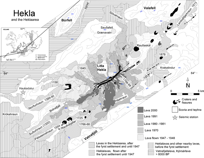
The 1766 flows are especially extensive…
The veidivotn fissure swarm belongs to Bardarbunga, a system with a much larger capacity. That’s not to say Hekla can’t do decent eruptions, just not on the same magnitude as Bardy.
Would be super interesting to see Bardy really get after it from under the ice sheet.
If you follow the fissures on a map, a part of Veidivotn continues to Vatnfjoll and Hekla.
Maybe Hekla is partially fed by Vatnajokull hotspot magma.
Veidivotn (and/or neighbouring fissures) intersects Torfajokull, but extrapolating a connection beyond this to Vatnfjoll (and then a bigger, further jump to Hekla) seems unlikely. I’m not aware of any petrology evidence for a Bardy source to any magmas in this area.
Once you live or visit the region, like I did, then it becomes clear the continuation of the Veidivotn fissures into the region east of Hekla. It’s easy to see the geological features of such landscapes.
This is not to say that magma travels from one into another volcanic swarm system. It can and it did several times in history, in other volcanic systems in Iceland. From Bardarbunga into Torfajokull. From Bardarbunga into Grimsvotn, Tindfjallajokull and almost into Askja.
So it could have happened theoretically between Bardarbunga and Hekla, or between Torfajokull and Hekla.
There is a lot of unknowns.
2014 showed that the unthinkable can happen: magma jumping between different volcanic systems
Which particular ridges and rows east of Hekla do you mean, can you provide coordinates as I wish to investigate further?
I certainly don’t doubt the system jumping feat, I’d just like to see some cold, hard data from a study in the area.
They are,all over gurgle urt. The lineaments are uncanny.
The trouble is, distinguishing between Torfajokull’s fissure swarm and the interjections from bardy – they both look similar. Not to mention most fissure rows point in the same direction here. With Vatnfjoll, I could see a possible connection to Veidivotn, but not with Hekla.
The 1766 lava field was huge and came from Hekla itself.
In 1878 and 1913 there were eruptions, both lava and explosive, outside Hekla, towards the dead zone.
This is one pic from the region. Not my pic but I have been often in the area. Lava field is large but not so much like Hokuhraun. It’s quite east from Hekla and lavas are basaltic, different than at Hekla.
Area is remote. Many many volcanic cones in the area show that eruptions there are common
Hekla, or surrounding region, is awakening again…
I wonder if hekla 1766 was part of the same activity that caused laki 17 years later? It was pretty big, at least comparable to holuhraun from what I have read, and there were probably other large eruptions before it. 40 years earlier in the 1720s there was also the myvatn fires which was very similar to the recent krafla fires, and the krafla fires ended about 40 years ago. Not saying there’s any causation but it’s interesting.
And another… Really small this time, but quite deep.
Friday
28.09.2018 00:33:36 63.988 -19.590 10.7 km 0.4 99.0 3.8 km E of Hekla
M 7.5 – 78km N of Palu, Indonesia
2018-09-28 10:02:43 UTC 0.178°S 119.840°E 10.0 km depth
Tsunami warning issued but the danger has mostly passed. Slip-strike event. USGS estimates ~800K people in the strong to severe shake zones.
It seems there MAY have been a tsunami.
https://www.bbc.co.uk/news/world-asia-45683630
Palu hit bad by quake and tsunami, it’s at the end of a long bay which would amplify the wave. Video and pictures show a mosque collapsed and then flooded by the wave.
Very sad news, there are sure to be many causalities
There was a damaging tsunami. Seeing the images, it seems possible that there were casualties.
I read how the tsunami hit nearly three hours after the main quake and almost two hours after the warning was ended. The seabed appears to slope steeply down from island of Sulawesi into the Makasar Basin. I image the first quake destabilized the slope and it collapsed hours later, likely from an after shock, causing an underwater landslide. A slip-slide event wouldn’t displace that much water when the fault itself ruptured.
The tsunami stuck as night was falling, very difficult conditions. And I felt so relieved when the initial reports said the danger had passed.
https://volcanoes.usgs.gov/vsc/file_mngr/file-192/PrelimSum_LERZ-Summit_2018.pdf
This is a summary of kilaueas eruption by HVO. The statistics they provide are very interesting, and a volume is given too, 1 km3 of lava was erupted. I dont know if this includes the amount below sea level though and so this could be a conservative estimate.
Just over 1 km3 in about 3 months, in terms of the ratio of rate to volume this is very probably the biggest effusive subaerial eruption on Earth since 1783…
I think this eruption has definitely shown that kilauea is not a pushover compared to mauna loa like is often portrayed, its neighbor might do faster eruptions more often but there is really no contest as to which volcano is the bigger erupter overall.
It’s not 1 km³ – the summary states 1,000,000,000 (American billion) cubic yards. That works out as 0.76 km³, so around half the volume of holuhraun.
That makes Leilani 2018 as large as Holuhraun
And its amazing that I reads that upper vents in Nyiragongo 2002 had temperatures of 1370 C
Based on chemistry and other complicated things
Nearly, holuhraun was between 1.2 – 1.6 km³ depending on sources.
It cannot be coincidence that the new volume of the summit crater and the estimated erupted volume are almost identical.
I personally doubt that there was much if any resupply during the entire event. Gravity draining the summit area plus some gas must have been pretty much the entire mechanism.
It seems like there is probably still an empty area down there where the nearly daily 5+ (1+ megaton of TNT equivalent) explosions occurred which, to me, further indicates that there was nothing welling up to fill in this empty zone. Plus, there would be more heat down there right now at the bottom of the new crater.
There would definitely be some resupply from the mantle, it wouldn’t make any sense for it to stop. Despite the changes to the surface there is no difference to the deep system and so the rate of resupply should be about what it was before this event, about 0.15 km3 a year. There is already some small activity indicating that new magma is rising into kilauea and going into the rift, at the moment it seems to stop around pu’u o’o but some apparently has seeped through at least once since the main eruption ended. It’s all still really small in comparison but when you consider it has only been 2 months since the eruption ended this is actually pretty significant.
Also by their own measurements through the eruption, that volume on the paper is most probably too low. I found that at the volume erupted from fissure 8 alone was about 1 km3 if it was erupting at 155 m3/s like they calculated after revising their numbers for the deeper channel, and the volume erupted from the other vents before that to be about 0.3 km3. Most of that difference is in the ocean underwater, where the sea was filled in as far as almost 400 meters in some places. Eruptions that had significant ocean entry should always be assumed to be minimum values, the ocean entry below sea level is most often neglected, and this is nowhere more apparent than for kilauea when you actually look at how much lava pu’u o’o erupted according to sources vs what it’s known steady eruption rate was times by its duration, same for mauna ulu. Both of them get way bigger, mauna ulu grows to about 1.5 km3 and pu’u o’o to about 11 km3…
It makes a lot of sense that an island would get bigger by putting material on its submarine slopes in order to grow in total, but I think this is ignored in everything.
Also in most of kilaueas earlier collapses the volume of the collapse is actually much bigger than the eruption, 1840 was determined to be a bit over 0.2 km3 and its collapse was close to 0.5 km3, over twice as much. 1823 was probably about the same but that eruption was maybe only 0.1 km3 at most, 4-5 times as much. 1832 was an even bigger collapse and there was no flank eruption at all.
This eruption and its crater are about 1/1, it is actually unusual for a caldera on a basaltic volcano to be the same volume as the eruption that caused it. Going by 1840 for kilauea, a dike of about 0.2 km3 is roughly what is required to reach lower puna from the summit, then an arbitrary amount more for the eruption, so this activity involved more magma than the volume of the caldera. A lot of that difference could have come from pu’u o’o, but there is still some that is there and that is probably resupply. The summit is also still adjusting to the different stresses created by the new deep caldera, so much of it might not actually respond at all to new ground movement caused by magma unless it is going to be a huge eruption.
It’s not gravity, it’s pressure. The magma reservoir isn’t *at* the summit, it’s *beneath* the summit. Kilauea summit is around 1200m altitude – but the *upper* magma reservoir, where most of the magma for this eruption came from, is at around 2km depth beneath the summit – so it’s below sea level. And the main, lower, magma reservoir – through which all the magma erupted flowed – is deeper still, maybe 4-5km down. So the magma didn’t ‘flow down’ under gravity; it was ‘pushed up’ under pressure.
From Pietruzska et. al:
Same mechanism as any eruption; buoyant magma seeks the easiest outlet, controlled by pressure and tectonics.
Oh and ’empty area’? There are no significant void spaces at that depth; that’s *why* the summit collapsed; it collapsed into the draining magma chamber as it drained.
That’s a valid point. Gravity is still involved though, since the lithostatic pressure depends on the height of the rock above the chamber, the density of the rock and gravity.
After the magma starts draining, the pressure is kept up by the rock above collapsing. We saw that very clearly towards the end, that each collapse, signalled by an M5 quake (not explosion), caused a surge in the lava flow. That is what is meant by a gravity driven eruption.
The magma chamber is at the depth where the magma has (near) neutral buoyancy. That is a matter of the pressure from above, the density of the local rock, and the temperature. The vertical pressure is due to gravity, of course, and follows the topography of the surface. The neutral buoyancy depth is different where the surface is lower and so there is a net horizontal pressure, pushing the magma sideways towards area of less gravity – less weight. Of course, the deeper the magma the less it sees the details of the surface.
The importance of gravity could be seen very well in Bardarbunga, where the dike at every point went for the direction of steepest descent in the contours of the mountain. There was one point where this could have bene two directions, when it arrived at the saddle point southeast of Bardarbunga. It could have turned either north or south at the point. And indeed, it waited several days there before making up its mind. The lack of gravitational preference caused a delay, and probably also caused quite a lot of magma to accumulate at that point during the delay.
The magma could easily have turned south in which case Holuhraun would have been in the dead zone.
Buoyant magma behaves differently.
All true – I just blinked at BadWolf’s “gravity draining the summit area” – which left a distinct impression of the summit magma reservoir being a ‘header tank’ and the magma flowing ‘downhill’ under gravity to erupt at a *lower* elevation than the magma chamber – but that’s not the case at all.