
Welcome to the Volcano Café bar, a place for all things on or off topic and inane ramblings. There has been a need of late to find a place better suited to various theories, long comments and enthusiasm. This page will be less moderated than the main article pages and cleared out every month (this may change depending on use).
Have fun and don’t forget to tip the barman 😉
just stumbled on this – and I thought of Jesper 🙂 https://www.youtube.com/watch?v=3OcfhEy2VTw
Larger deep quake at Pahala, no tremor
2019-09-02 16:23:50 3.6 32.1
Amazing that this is still going on.
The lake is still growing and is now expected to eventually reach 70 meters depth, being the expected level of the water table
A flyover from the other day. https://youtu.be/wL9_tVaBnfs
Again an “automatic” 3+ quake with a Kilauea quake logged about 45 seconds later.
M 2.6 – 3km WSW of Volcano, Hawaii
2019-09-02 16:24:36 (UTC) 19.422°N 155.275°W 0.2 km depth
Although the 2.6 is “reviewed” despite being later.
This comment took almost a 1/2 day to show up.
I saw it on time, so I suspect that your system didn’t update as it should.
Finally went to “reviewed” with a big downgrade
M 1.6 – 4km SSE of Pahala, Hawaii
2019-09-02 16:23:50 (UTC) 19.174°N 155.461°W 33.1 km depth
And another pair at 46 seconds apart
1.9 4km SW of Volcano, Hawaii 2019-09-03 21:12:38 (UTC) 3.7 km
2.5 6km SE of Pahala, Hawaii 2019-09-03 21:11:52 (UTC) 35.0 km
I’m at a local Waffle House for a BLT. Sky is gorgeous. Scattered fluffy white cumulus against a deep blue sky. All flowing gently with the extreme outer influence of Dorian down off the Miami coast.
BULLETIN
Hurricane Dorian Advisory Number 38
NWS National Hurricane Center Miami FL AL052019
500 PM EDT Mon Sep 02 2019
…EYE OF DORIAN MOVING LITTLE WHILE THE HURRICANE CONTINUES TO
POUND GRAND BAHAMA ISLAND…
SUMMARY OF 500 PM EDT…2100 UTC…INFORMATION
———————————————-
LOCATION…26.8N 78.4W
ABOUT 25 MI…40 KM NE OF FREEPORT GRAND BAHAMA ISLAND
ABOUT 105 MI…170 KM E OF WEST PALM BEACH FLORIDA
MAXIMUM SUSTAINED WINDS…145 MPH…230 KM/H
PRESENT MOVEMENT…STATIONARY
MINIMUM CENTRAL PRESSURE…940 MB…27.76 INCHES
One thing I know this isn’t good- but it will suck all the heat out of the ocean and will drop in intensity as it runs out of fuel-I still would not want to be there…
Gulf Stream is running 30.4+°C. It lies between Dorian and the US Coast right now. In 1989 Hugo ramped up intensity quite fast when crossing it. Interestingly, my cousin that I mentioned in an earlier comment rode that one out as it blew past several miles inland. Her dad wound up cooking everything in the freezer until power came back on. My 2004 Ivan experience was less dramatic. I had the freezer on Generator and just cooked a sack of potatoes for sustenance as needed. {Essentially, we lived in the screened in porch for 4 weeks. Too hot to hang out in the house.}
Advice for anyone winding up in a similar situation. DO NOT power your computer directly off of the generator. Put a decent UPC between it and the computer. The UPC is made to handle dodgy line power, and if the generator runs out of fuel while you are using the PC, it won’t kill the computer’s power supply as it ramps up and down in voltage and varying phase as it stalls out. And if the UPC croaks from the abuse, at least it did it’s job and protected your computer. (Though you may run into warranty issues with the UPC manufacturer if you try to file a claim. Generally they only cover line connected equipment)
Caveat: Though I have worked in electronics for 38+ years, you are responsible for your own actions. However, this is a sound way to use your computer with a generator. I have no preference for brands. Triplight and APC are both equally adept at making high quality UPCs. (Battery Backup power sources) (I’ve worked with both) {I do like the SU2200 by APC, it has 4 x 12-18aHr batteries and gives a pretty decent run time before the UPC gives out} {What I don’t like about the SU2200 is that it is a pain in the ass when the batteries swell and you have to drill out the rivets in the lower chassis frame to get them out, re-riveting it back together before you put in the new battery set.} Triplight isn’t immune to swollen batteries either, but I have not had as dificult a fight with them. (Triplight 1500) → 12-7.5aHr batteries.
Opinion- APC equipment tends to be a bit more rugged, though the front panels on the SU2200 are a bit fragile.
Downside… I have a couple hundred pounds of croaked batteries stacked in my garage. (waiting until the prices are right to sell them to the scrap metal guys) {They are probably worth a couple of tanks of gasoline}
NEVER toss batteries in the trash. In a landfill, the lead can leach out and pollute the groundwater. Here in Escambia County, there is a hazmat round-up a few times a month where you can dispose of any hazardous chemicals or items you have accumulated. My thing about selling the batteries for scrap is just a side “hobby” of sorts. I just happen to accumulate croaked batteries at a rate where it’s a viable option. At one point, I had a grandkid begging me for my stack of batteries so he could get gas money. (it was a particularly large stack at the time) My cut came out to about $40 and he hauled them off 😀 .
Side Note. When you replace battery sets, invariably you will eventually wind up with still operable batteries from time to time. It is not uncommon for one battery in a set to fault and cause the UPC to error out on the battery set. Out of a set of 4, sometimes you wind up with one or two that still show low internal resistance and can still take a charge. I keep a couple of 12-18aHr batteries around fully charged. With a DC to DC inverter for USB power, I have the perfect set-up to recharge my phone no matter what happens to the power grid here. Plus I can get an obscene number of charges off of one of those batteries for my phone. (218 VA)
Thanks, thought it was a bit farther out….I just had $200 bill for my Toshiba.
UPC-croaked during a lightning storm did have a GFI plug on it. could have been worse..
I love that Toshiba…
Yeah, I’ve got one also. → Because my grandson broke one that belonged to a friend of his girlfriend. Cracked screen. I wound up doing the repair gratis if he bought the parts. Due to the ease of getting into and out of that thing, when I needed a new one, I bought the same model. I’m quite happy with it. (I previously had a “NetPC” mini laptop that didn’t like being opened up when a memory module had croaked. I loved the small form factor of that thing but it was just too complicated to work on. (complicated in that interlocking tabs and screws were overly tedious) At least it wasn’t as bad as an apple product where you spend an hour getting into it only to find that the ultra deep innards are held together with glue.
Worst voltage related casualty I had was on a piece of military equipment. Blew my spike arresters in the main power distribution panel. The guy in charge of the Motor Generator (MG) sets for my 440vac line came into combat quite proud of himself that the MG sets “only had a 540 VAC transient” and had held the load during an engineering casualty on the ships main plant. I was livid. A flat out drop of my power would have been quite fine and my gear would have had no problem with it. But the fluctuating supply voltage had caused my damage.
Karma being what it is, a month or so later, he approached me with a plan to reduce the maintenance work his shop had to do on those MG sets. He wanted to take all of Combat Systems down to a single MG set for normal operations since my gear and TAS were pulling such a low current load. I asked if his single MG set could handle 150 amp draw in the event that I went to “Full On.” He laughed and said of course not. I stated “then you better not do it. If we get an inbound missile, I have to go to full on or else we could buy the farm. He just mumbled and wandered off. Later, during a War at Sea exercise, out comes a LearJet flying a missile profile with the appropriate missile radar. As required by the battle orders, I engaged it. His MG set cooked off in about 2 minutes. He had taken all of Combat systems down to a single MG set despite my warning. {The Learjet saw my 2 minutes of jamming and counted it as successful and went off to annoy another ship in the group.}
What really ticked me off about it, was that he then blamed me for his system casualty. This later led to the Fire Control Chief and myself having a fairly heated discussion about which of our two divisions would take on maintenance responsibility for the MG sets. I won that argument on the grounds that we would happily take on the MG sets if his division took responsibility for the Torpedo Counter measures system. My argument was that that system usually falls under his department purview on normal combatants. The only reason we had it was that the equipment designation was similar to my main equipment and some wingnut had given it to us in the first place since they didn’t know any better. So, if STs (who normally handle it) are part of Combat Systems, he should own the gear. Yeah, I had brought that system back from the dead as one of my first issues that I had to resolve when I reported on board, but neither I or my group had any expereince with it at all, maintenance or otherwise. {If you have decent service documentation, troubleshooting is cake. All I needed was an NSWC guy to come out and TDR the fiber optic cable and later do a splice on the the line} (another idjit with a screwdiver had severed the cable while trying to poke a hole for a CATV cable for the TV in his shop)
(Improper modifications to the ship’s wiring plant can get you killed.) I was doing a deinstall on another ship, after tagging out every source of power, I still managed to blow the end off a pair of pliers when I cut a live line. Paranoia saved my arse on that one. I had on 10kv gloves and muffs along with a face shield. Some “brilliant” individual had used my line as a source of power for something in another compartment and it was back feeding into the line on my side of the circuit breakers.) Since it was just a fan control circuit, it had never given me any troubles. The component I was removing (Fan control relay box) took a signal from my gear to power up the fans and as long as some sort of power was there, it didn’t care. As for my near electrocution, I notified the ships electricians mates about the improper wiring and let the safety officer know that I was still alive despite the ship’s effort to make me less so. As for the Electrician’s mates, it was more of heads up that something on that breaker my have a problem now. As for the end of the pliers… I dug it out of the insulation on the bulkhead where it had lodged. Why the de-installation? The ship was being decommissioned and my equpment had to be ready for removal to facilitate grooming and reuse on a newer ship, or to go into the USN spare parts inventory.
so i’ve mentioned this before and not meaning to be armageodonish but i’ve always wondered scientifically if earth could develop a “Great Red Spot” or continuing hurricane like jupiter? Anyone? Anyone?
Well partial answer as I said above -heat source -Hurricanes/Typhoons need oceanic heat. Earth doesn’t have the deep heat that the red spot uses..
I agree. Though I don’t know the power source for Jupiter’s spot. It might be a byproduct of the dynamo effect since it is thought that at some depth, Jupiter has a layer of liquid metalic hydrogen. A highly conductive layer like that should be very energetic when flowing around.
Closest equivalent would be the Antarctic storms that putter along in the roaring forties, they can do several laps around the world before dissipating.
The great red spot is very diffrent from any earthly storm!
This storm does not get any energy at all from sunlight..
Instead it feeds from jupiters immense internal heat stores.
All weather on jupiter is acually moist heat rising up from the planets searing depths.
In jupiters cold higher layers… water vapour, ammonia condense into the clouds we see on jupiter. Jupiters fast rotation spinns the convective columns into large bands.
Beacuse its feeding from jupiters internal heat..and convective, the coud top temperatures in jupiter are very much the same.. – 140 C on pole and equator.
Great red spot is acually a high pressure region… its an anti – cyclone thats spunned between jupiters many jet streams.
Great red spot feeds from internal heat.. not air mass diffrences
Jupiter is the most massive of all planets,…
Thats why it haves also the largest ammount of internal heating
Earth is stone cold in comparsion
Jupiters center maybe 30 000 C or more
This heat store drives the gas giants violent weather as it plays togther with a very very rapid spinn. Jupiters polar regions where jet streams are weakest are a convective mayhem of thunderstorms and small storms .. all this heat trying to get out.
Earths storms= powered by suns heat and air mass temperature diffrences
Jupiters storms = Powered by the insane heat within jupiter and the rapid spinn of the planet
The Great Great Spot cannot be compared with any earthly storm : )
GRS is not powered by solar heating, and not by baroclinic diffrences either
Its feeding from internal heat
Maybe its a kind of atmospheric gas giant air volcano
IIRC, there are still arguments raging over whether GRS began as an ordinary storm which ‘went large’ by eating enough neighbours, or was result of a BIG impact event, whose initial big storm became self-sustaining by eating those neighbours…
YMMV.
Finally moving along at a a crawl.
BULLETIN
Hurricane Dorian Intermediate Advisory Number 40A
NWS National Hurricane Center Miami FL AL052019
800 AM EDT Tue Sep 03 2019
…EYE OF DORIAN BEGINNING TO INCH NORTHWESTWARD…
…SOUTHERN EYEWALL CONTINUES TO POUND GRAND BAHAMA ISLAND…
SUMMARY OF 800 AM EDT…1200 UTC…INFORMATION
———————————————-
LOCATION…27.1N 78.4W
ABOUT 40 MI…70 KM NE OF FREEPORT GRAND BAHAMA ISLAND
ABOUT 110 MI…175 KM ENE OF WEST PALM BEACH FLORIDA
MAXIMUM SUSTAINED WINDS…120 MPH…195 KM/H
PRESENT MOVEMENT…NW OR 325 DEGREES AT 1 MPH…2 KM/H
MINIMUM CENTRAL PRESSURE…952 MB…28.11 INCHES
Eye has pretty much filled in as its sapped the available heat from the water around the Bahamas. The projected track seems to follow the gulf stream for quite a bit. I’m wondering if it’s gonna deplete a stretch of it of the available heat. Could that make the up coming fall a bit cooler for Europe? Gonna be interesting to see what comes down the line there in the next few months.
What a question. The typical power of hurricane is around 10^14 W and the heat power (in winter) of the Gulf Stream is around 10^16 W. Dorian is not a typical hurricane though, and in Europe it is still summer (This is relevant because the heat comes from the temperature difference between the stream and the ocean which is less in summer). So from that, yes, if Dorian is re-amplified to a category 5 (which is NOT predicted) it could have some effect on Europe. On the other hand, the energy is transferred to the air, and if this reaches Europe it will cause warm weather, followed by a bit of cooling once the depleted bit of the Gulf stream arrives. A colder North Atlantic makes a blocking high more likely, so this could -in theory- give us some continental weather. The continent is still quite warm, so this wouldn’t be necessarily a colder phase. The most likely impact is that the remnant of the storm itself comes here. The autumn equinox is traditionally the time here we can get sudden storms – those are from the hurricane season.
This shows the sea surface temps with the effect of the stall clear.
ZNS Just with a live report from the Emergency Operations Centre in Freeport – they estimate 75% of the Island went underwater. Levels have dropped only a little.
That was that Island 🙁
Latest Hurricane Flight data shows the eye again closed and circular with a diameter of 55 nautical miles!
A. Time of Center Fix: 4th day of the month at 14:21:50Z
B. Center Fix Coordinates: 29.70N 79.66W (View map)
B. Center Fix Location: 90 statute miles (144 km) to the ENE (68°) from Daytona Beach, FL, USA.
C. Minimum Height at Standard Level: 2,792m (9,160ft) at 700mb
D. Minimum Sea Level Pressure: 964mb (28.47 inHg)
E. Dropsonde Surface Wind at Center: From 310° at 1kts (From the NW at 1mph)
F. Eye Character: Closed
G. Eye Shape & Diameter: Circular with a diameter of 55 nautical miles (63 statute miles)
Do you know the direction it is travelling?
…DORIAN MOVING PARALLEL TO THE NORTHEASTERN COAST OF FLORIDA…
…RAINBANDS BRINGING HEAVY RAIN AND GUSTY WINDS TO THE SOUTHEAST US
COAST…
SUMMARY OF 1200 PM EDT…1600 UTC…INFORMATION
———————————————-
LOCATION…30.0N 79.7W
ABOUT 95 MI…155 KM ENE OF DAYTONA BEACH FLORIDA
ABOUT 195 MI…315 KM S OF CHARLESTON SOUTH CAROLINA
MAXIMUM SUSTAINED WINDS…105 MPH…165 KM/H
PRESENT MOVEMENT…NNW OR 335 DEGREES AT 9 MPH…15 KM/H
MINIMUM CENTRAL PRESSURE…964 MB…28.47 INCHES
New dropsonde, just from a few minutes ago, has pressure down to 963.
You can see the eye quite well on Jacksonville radar
https://radar.weather.gov/ridge/radar_lite.php?rid=jax&product=N0Z&loop=yes
Near Kesler syndrome courtesy of Elon?
https://www.thesun.ie/tech/4508949/elon-musks-rogue-starlink-satellites-nearly-crashed-into-european-probe-as-fears-grow-humanity-will-be-trapped-on-earth-by-billionaires-space-junk/
Flyover video of Marsh Harbour, Abaco
About 90 percent destruction assuming that the houses standing up are damaged.
🙁
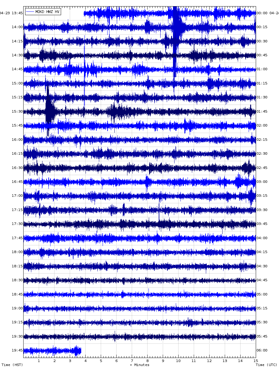
Does anyone have any idea what this weird signal is? It is showing in the seismometers around the summit of Kilauea:
It looks like many small brittle failures followed by some weak tremor but with my lack of knowledge on seismology I can’t really tell.
The ground tilt at Uwekahuna is right now dropping but it is probably another DI event starting that I am guessing is unrelated since they usually don’t show much correlation with other activity.
What is probably related to the seismic signal is the swarm ongoing at the summit which is getting quite important and also shows in the seismogram.
The HVO Labor day party?
Oh my!
Might be some construction work that needs to be accomplished at night. It is around 3 times a min. . I am guessing a small front end loader doing some work (moving concrete) or maybe a paving machine rolling over fresh hot Magma for a road.
Mac
Rockfall would be my guess without looking to closely.
The new caldera walls are incredibly unstable, and this could be sequential slides.
The new caldera is indeed extremely unstable and its still very hot in places
here is a new photo from HVO.
Kilauea is perhaps the worlds hottest volcano in heat loss.
The geothermal lake have grown really large now, but its still 70 C
Suggesting enromous ammounts of heat is feed to the lake thats likely 20 m deep now?
Look a all this sulfur in the caldera walls.
Image replaced by preview version. Jesper, copy the image address, not the link address. The former is the small image, the latter is the full sized version
I trys to load it in lower resolution but Im so poor at computer things
How do you do it? these files crash the blog I knows
With what it is going on I was thinking more of something volcanic…
After plotting the earthquakes in IRIS it seems Kilauea is right now doing its most intense swarm since the eruption ended in terms of number of earthquakes, it also breaks with the pattern of previous frequent very shallow swarms that seemed to be the caldera faults settling. This one is spanning 0-15 km depth.
There was also some tremor at 23:00 showing broadly through the island, question is who did it? Kilauea or the Pahala conduit?
Some good news. Well known storm chaser Josh Morgerman, who had been out of contact and many were worried for, is safe.
https://twitter.com/iCyclone
Continues
Josh Morgerman
Verified account @iCyclone
8 minutes ago
Frantically piled into few functioning cars (one of them mine) & relocated to government complex before backside struck. Building filled with terrorized refugees, many who had swam to safety or abandoned collapsed houses. The calm eye saved lives—gave victims chance to relocate.
Josh Morgerman
Verified account @iCyclone
4 minutes ago
Whole neighborhoods were swept by mighty surge higher than anything in memory. Areas above water had catastrophic wind damage. Many deaths reported from drowning, flying debris, & collapsing houses. Medical clinic overwhelmed. An absolute catastrophe. SEND HELP TO ABACO ISLANDS.
The sad part is that there will be no help coming, unless of course China or Putin wants a naval base next door to the US.
M5 at Taupo
5.2 at ~5km
Here’s the drum (live link)
httpsx://cdn.star.nesdis.noaa.gov//GOES16/ABI/SECTOR/EUS/GEOCOLOR/GOES16-EUS-GEOCOLOR-1000×1000.gif
Dorian is now over the warm Gulf Stream
And it seems to strenghten again
Replaced gif with a low res image. To get the gif, remove the ‘x’ in the link and open somewhere outside of VC..
That’s a 36 MB gif you just posted!!!
Wouldn”t be so bad if the NOAA server wasn’t overloaded – took about 5 minutes to download completely for me.
Gaz fix this please
Yes that file was way too large for VC
How did Gaz Dale get in his animation without lag?
If you re-upload images to commercial image sharing sites they usually have the bandwidth (and also use edge-caching content delivery networks – ie the image is cached at or close to your ISP) and even an image that size would download in a few seconds on a decent connection. Hotlinking very large images from government sites completely overloads their own uplink bandwidth.
Recent IR image shows Dorian looking like it is getting its act back together.
The central dense overcast must get colder
Compared to what it looked like earlier, the tops are already much colder.
Latest Euro run has wind gusts over 70 mph for the whole of South Carolina coast then up to over 100 mph in North Carolina
With the coast penetrating the eye, would that count as landfall?
By the NHC’s definition it has to be the centre over the coast. However I think they can get a little creative if it is very close.
Latest NHC update has Dorian back up to almost Cat 3 (1 mph below Cat 3) and pressure down to 961. Possibly actually now sub 960 from recent dropsonde.
SUMMARY OF 500 PM EDT…2100 UTC…INFORMATION
———————————————-
LOCATION…30.6N 79.8W
ABOUT 150 MI…245 KM S OF CHARLESTON SOUTH CAROLINA
ABOUT 275 MI…440 KM SSW OF WILMINGTON NORTH CAROLINA
MAXIMUM SUSTAINED WINDS…110 MPH…175 KM/H
PRESENT MOVEMENT…NNW OR 345 DEGREES AT 8 MPH…13 KM/H
MINIMUM CENTRAL PRESSURE…961 MB…28.38 INCHES
Who said this storm wasn’t impacting Florida?
I just knew that Floridaman would get involved somehow. 🙂
The strongest Cat 5 hurricanes develops tiny tiny tiny pinhole – eyes where winds can be as strong as a really strong F3 tornado or even higher.
Hurricane Wilma is the most intense tropical cyclone eye ever seen. The eye became a narrow cylinder only 3 kilometers wide
The extremely intense eye of Hurricane Wilma 2005
That tiny pinhole eye!
It became much smaller closer to Mexico narrowing into a 2 km wide cylinder with weak F4 equalent winds screaming around the eye…. extremely intense.
Luckly none was in the pinhole eye
https://www.youtube.com/watch?v=4_adR-yTW2A
Crazy intense storm that was with souch a tiny eye
But I knows that pinhole eye hurricanes are usualy most intense
Since it is geological live action:
I have opened a Mannen mountain collapse watch comment string on the main article.
Complete with live feed.
All things Mannen to be discussed there. 🙂
NHC just called landfall
483
WTNT65 KNHC 061255
TCUAT5
Hurricane Dorian Tropical Cyclone Update
NWS National Hurricane Center Miami FL AL052019
900 AM EDT Fri Sep 06 2019
…DORIAN MAKES LANDFALL OVER CAPE HATTERAS…
Surface and radar data indicate that the center of Hurricane Dorian
made landfall at 835 AM EDT (1235 UTC) over Cape Hatteras, North
Carolina. Maximum sustained winds were near 90 mph (150 km/h) with
a minimum central pressure of 956 mb…28.23 inches.
A Weatherflow station at Ocracoke, North Carolina, recently
reported a sustained wind of 73 mph (117 km/h) and a wind gust of
89 mph (143 km/h). Other stations at Hatteras High School and
Buxton both recently reported a minimum central pressure of 957
mb…28.26 inches.
SUMMARY OF 900 AM EDT…1300 UTC…INFORMATION
———————————————-
LOCATION…35.3N 75.5W
ABOUT 5 MI…5 KM NE OF CAPE HATTERAS NORTH CAROLINA
MAXIMUM SUSTAINED WINDS…90 MPH…150 KM/H
PRESENT MOVEMENT…NE OR 50 DEGREES AT 14 MPH…22 KM/H
MINIMUM CENTRAL PRESSURE…956 MB…28.23 INCHES
$$
Forecaster Blake
Any thoughts on recent M5 and M4 activity in Dem Rep of Congo?
Just watched an absolutely horrendous “The Aftermath of Dorian” on ZNS (Bahamas TV). Can’t really put it in words right now. One segment is from their reporter and cameraman based at the Emergency Operations Centre on Abaco Island – which itself had to be evacuated during the storm.
Reports suggest that several thousand people may have died.
Yes, the words they used were “The final death toll will be staggering”. In addition to Abaco Islands, East Grand Bahama is completely destroyed,
https://twitter.com/TropicalATL/status/1169988710500380673
The radar loop really makes clear why.
https://twitter.com/CopernicusEMS/status/1169870234972381185
Before and after image at link.
http://bahamaspress.com/2019/09/05/an-environmental-disaster-unfolding-in-east-end-grand-bahama/
High Resolution damage survey –
9-7-2019 High Rock Bahamas Catastrophic Oil Spill from Hurricane Dorian
https://weather.com/storms/hurricane/news/2019-09-06-dorian-major-oil-spill-bahamas
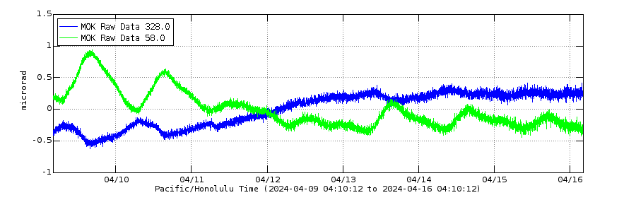
A M 3.2 at 05:58 and -0.1 km deep in the summit of Kilauea has shot up the UWE tilt about 35 microrradians, not that far from the deformation of 50-100 microrradians the collapse events of past year caused. However the earthquake was centered just below Uwekahuna Bluff where the tiltmeter is located and with other stations in the caldera not showing much effect it seems the deformation is large but very localized. In terms of size it must be similar to other events in June and July of this year but this one happened closer to the tiltmeter.
A ring fault still releasing strain from the collapse of last summer (I guess).
Thanks DustDevil. I was trying to figure out what happened.
I been through tropical storms before in Mexico and Florida .. these are huge oceanic convective storms
With anvils that can be 200 km across and 60 000 feet high. They bring rain is heavy as hell and unpleasant winds.
But in almost everyone I been in in my vacations.
There been near compete lack ligthing… activity.
Hurricanes and Tropical storms… have almost no ligthning at all … why ?
Albert and I discussed this in the back channel a while back with no definitive conclusion. I was arguing a high mixing rate that kept the charges from accumulating. Before there was any progress on the topic I ran across a paper somewhere that stated that lightning in the feeder bands were indicative of strengthening. This makes sense when you note that feeder bands are just normal thunder storms that are lined up along a spiral path.
As for the eyewall… well. Ya got me.
One thing to note is that tornadoes tend to be a bit devoid of lightning also. Yeah, the thunderstorm will likely be quite energetic with it, but from the only example I have seen first hand, the funnel itself was completely dark.
Yea Im curious Albert!
These tropical storms can have intense convective cores with real monster MCS and overshooting boiling 60 000 feet tops over 150 km wide
Yet … there is almost and sometimes competely lack of any lighthing at all!?
Tropical systems are very electricaly silent
This from The Washington Post – partially paywalled – extract below
https://www.washingtonpost.com/weather/2019/08/30/lightning-barrage-hurricane-dorian-may-signal-rapid-intensification/
The End of “Hurricane” Dorian but not yet the storm with Canada landfall still to come.
“Post Tropical” means that the storm has lost pr is loosing it’s warm core characteristic. Symmetric Warm Core lows are what become tropical systems. When the system interacts with a front, they usually become unstable and shift towards a cold core form. By the time they get to the vicinity of England, they are usually strong frontal lows.
Reminds me of the most infamous UK weather forecast ever.
https://www.telegraph.co.uk/men/thinking-man/weatherman-michael-fish-missing-great-storm-1987-saw-happened/
Technically of course he was correct – it wasn’t a hurricane (not even an ex-hurricane) – but the impact was pretty much the same.
IIRC, Met Office leveraged that debacle into funding for a new super-computer that could wrangle more lower-probability fore-casts…
I look forward to no more Dorian, but not quite yet.
What is left of Dorian is headed off to merge into the semi-persistent Icelandic Low {eventually}. It’s where these storms go to fade away.
https://www.cbc.ca/news/canada/nova-scotia/recovery-begins-across-maritimes-after-hurricane-dorian-1.5275155
An interesting view into how London VAAC is working!
https://www.volcanocafe.org/london-vaac-calling/
Another significant quake at Pahala. There is an indication that the quakes are (marginally) shallowing. It is a pity there is no working GPS nearby. The ones on the southern flanks of Mauna Loa all show some deflation, while the summit is still inflating. That suggests the magma chamber is now fairly high up in the edifice. But it doesn’t seem related to Pahala.
Thats intresting
Maybe Mauna Loa is about to change from large fast short lived rift eruptions …
To more constant slow long lived Puu Oo like activity.
Basicaly slow pahoehoe – tube feed eruptions?
With a shortage of gps data, I presume interferographic images could be used. As there apparently isn’t a shallow magma chamber near Pahala, it seems unlikely to me that they would show anything.
Status is now reviewed
M 3.5 – 7km ENE of Pahala, Hawaii
2019-09-10 08:24:09 (UTC) 19.233°N 155.413°W 32.3 km depth
A lot of the south side GPS units are also showing that they are slipping south.
WOT … (way off topic; even for the bar) interesting phone scam this morning….. apparently my computer support package will be renewed and $299.00 will be added to my charge card… for more info call blahblahblahblah…. i don’t have a charge card. So elderly marks out there: be warned. and it is difficult to live without a card but makes phone scams a slam dunk.
Interesting one. We do get the phone calls ‘there is a problem with your windows..’ which are easily caught because of the US phone number.. Bursting out laughing tends to work.
Yeah, I get amused by the “there is a problem with your credit card” calls. That and the email spam from “Wells Fargo” whom I have never banked with. (No specific reason, they just didn’t have an office where I lived)
My fave is: “Buy/renew your extended warranty for you 2005 Pontiac Montana.”
It has been turned into a Hyundai by now…
I get spam phone calls in Chinese. I have no idea what they are trying to sell me. Chinese population is one city over, not where I live.
Last Spring, I got one claiming to be from Microsoft Support, informing me I had a pernicious virus on PC and to down-load their patch.
Usually, I’d mention my paranoid Norton’s, say something acceptably rude and hang up, but…
Happens my CAD-Tower PC was really struggling to install that season’s massive Win’10 update. Day after day, week after week, the PC would slowly load the iteratively up-dated update, get a bit further before re-winding and re-booting.
Also, Microsoft had, after a decade of leaving well alone, ‘improved’ Notepad and broken its word-wrap function. Took me a while to convince their support forum, for it was a subtle bug…
And this perp claimed to represent Microsoft ??
Fair enough.
Ten wasted minutes later, still unable to get a word in edgewise, he escaped my monologue by ringing off…
😉
Had trouble with the latest Win 10 patch-after getting mu computer back
-and new hard drive. So Microsoft redid the patch.
They:
1. won’t leave well enough alone.
2. If it works- fix it.
3.Make sure the New patch will require
hours and hours phone time.
Microsoft operate under the idea of:”It’s a feature not a bug.”
Little group of quakes including a 2.9 nw of Kilauea around the 5000′ elevation, with depths ranging from 1 to -1km
2019-09-11 18:18:05 2.2 0.9
2019-09-11 16:26:58 2.2 1
2019-09-11 15:33:43 2.1 1.5
2019-09-11 14:48:37 2.1 -1
2019-09-11 14:22:33 2.9 -0.2
2019-09-11 13:36:00 2.8 -0.5
I have a question for Carl and Albert
Nyiragongo and Nyiramuragira are Africas most productive volcanoes.
Specialy Nyiramuragira most eruptions in Africa.
Why are they so active? when the magmas are superalkaline and the product of hardly any melting at all.
Basanite and Nephelinites that these volcanoes produce are products of very very small ammounts of partial melting. Yet they are so active?
These magmas are the product of hardly any partial melting at all.
Nephelinites and Basanites are produced in tiny ammounts globaly.
Often as monogentic cones
Not lava lakes and vigorous growing young shields
New post is up. Volcanoes and modern life – with a cameo by Frankenstein
https://www.volcanocafe.org/tambora-the-lost-summer-and-the-hobby-horse/
Find Yourself in Iceland!
A very Icelandic thing indeed! 🙂
Another visitor?
https://minorplanetcenter.net/mpec/K19/K19RA6.html
Interesting.(I don’t mean like the Enterprise popping out of warp in the middle of the Romulan battle fleet “Interesting” Spock type statement.) but what are the odds of another “visitor”?
As long as it keeps moving….
There will be quite a lot of interstellar objects passing through the solar system. They have just been very hard to find. For this particular comet the jury is still out though. We need to show it can’t be an Oort cloud object that was perturbed into this orbit.
IIRC, now estimated to get a dozen or so ‘out-riders’ a year but, unless they are large and/or grow a tail, they are very hard to spot. Comet-hunters, all-sky surveys and searches for hypothesised ‘Planet-9’ / ‘Planet X’ etc will surely turn up more as algorithms are tweaked.
Analogy is how, after Shoemaker-Levy 9’s spectacular demise, Jupiter-watching became more popular, and more impacts were duly spotted. Including, IIRC, a very recent one. Ha ! Found it !!
https://phys.org/news/2019-09-stony-iron-meteor-august-impact-jupiter.html
fair-use quote:
Analysis of a bright flash in Jupiter’s atmosphere observed by an amateur astronomer in August 2019 has revealed that the likely cause was a small asteroid with a density typical of stony-iron meteors. The impact is estimated to have released energy equivalent to an explosion of 240 kilotons of TNT—around half the energy released in the 2013 Chelyabinsk event at Earth.
/
A mere dozen metres diameter, just 400~500 tonnes….
Nyiragongo is quite unusual and very active for being a Nephelinite volcano. Nephelinite is the product of the very smallest levels of partial melting of mantle rocks deep down. Its superalkaline and super – sillica undersaturated.
Nephelinites are usualy never made in any large ammounts.
Its very supprising its made in ammounts that makes Nyiragongo lava lake activity possible.
When I think of Nephelinites
I think of small monogentic cones and monogentic fields in the rift.
Not a very active stratovolcano and a huge permanent lava lake
Yes….the productivity of such an alkaline system is note-worthy!
https://nypost.com/2019/09/14/dorian-relief-suspended-in-bahamas-to-prepare-for-tropical-storm-humberto/
What little relief there now was.
I tried to find a good organization to send money to for Bahamas today, and it was not that easy.
Currently if I understand things correctly, the remnants of Dorian is blowing over Sweden, meanwhile the third hurricane is about to hit the Bahamas after Dorian and Joaquin.
The world has turned into a cruel and cold place where an entire nation can be destroyed, and the world just goes “meh” on it.
I agree, I wonder why people don’t ask themselves what if it were me or my family that needed help. I was so proud of America when we had the heart to form the Peace Corp, today’s selfishness makes me ashamed, my flag sits in the closet there is no reason to wave it proudly.
Anak Krakatau appears to have developed a hot spot within the crater lake
we just had a little shaker…. 5.2 but i think it’s a new quake; not an aftershock of the 7.1 of November last. i hate the earthquakes that make me wait for them to stop. And even tho i was taking a nap it still hurt my back. nuts… now to wait for the aftershocks… and it was a long one so it will be interesting to see if there are more or less of them. (side note… didn’t hollar earthquake because i thought since i hadn’t heard anything from my husband then he must be asleep in front of the tv……………………………………… nope….. should have seen his face as he exited the bathroom. ) poor guy. Well Best!motsfo
Seiche?
I would have hastily exited the bathroom as well, water that doesn’t stay where it is supposed to is unnerving.
and on a sober note… 2am this morning we hear that one of the kids (ok, they are 50ish) friends died when a jack that was holding up a vehicle that he was working on, colapsed. Need more info to check on timing but it’s sad…. it was a long earthquake and possible set up some building momentum.
I am very sorry to hear that. Although it makes little difference, I hope it wasn’t the earthquake
The drone attacks on Saudi Arabian oil installations have been said to come from north by north west; somewhere in Syria by the sound of it. Who has long range drones in that neck of the woods and who benefits, I wonder.
September 2019 http://hraun.vedur.is/ja/vatnajokulsvoktun/grf_uppsafn.html
Here is my update on Grimsvötns cumulative seismicity. Earthquake activity have become a bit more frequent since 2017 but its still not the even rising steep climb that it was after 2004 s event. The Earthquakes are caused by the magma body expanding and pressning on brittle bedrock walls.
The volcano is refilling but it still seems to be Re – covering from the huge 2011 event. There been numerous strong swarms thats increased pressure alot and in 2018 the volcano seems to be started a slow steady climb knowing it haves the highest magma supply in Iceland. Still it can be rather tricky we may never know how the plot will behave.
This is a good way to learn just how much Grimsvötn can recover after a large volcanic event
And it seems its refilling pretty well after 2011 s event. Knowing the diffrence between magmatic quakes and tectonic ones can be a bit tricky.
Grimsvötn arera is open conduited and experience little quakes overall only major rifting or as this case increased magma pressure in the upper magma chamber. GPS on ground says Grimsvötn arera have inflated almost 50 cm since 2011 and thats another sign of magma Re-charge.
The increasing earthquakes I takes for an expanding upper magma chamber that stress bedrock.
The next eruption is impossible to predict for the moment as the plot needs to behave in a more straightforeward manner I think ( steady increased climb like the 2 events before ).
It will likley take longer for it then between 2004 and 2011 knowing 2011 was a rather large event.
But Grimsvötn seems to be recovering from last event.
Still after last years and specialy late 2017 s slow flatteing its now steeper again.
M2 at Mauna Loa, only 1 km below the summit. I think this is the highest listed quake I have seen there
Leilani fissure 8, August 2019 (HVO)
The big island is taking a much needed nap.
Me thinks not.
Mauna Loa had a glitch from the shallow quake yesterday
Two of the seismometers on the summit have gone shaky (could be weather)
Kilauea is re-expanding at a rate which will bring it to pre-eruption values within 5 years
And the DI events keep continuing. These are funny since it means two magma chambers are communicating. Which ones?
The current model is that Kilauea has 2 main magma chambers, the shallow 1 km deep resevoir under Halema’uma’u which seems to be the source of DI events and another 3 km deep under the south caldera rim area. Do you have a take on how DI events work? because HVO doesn’t have much of an idea.
It is hard to know exactly what happens but there are clues. They were seen both at Kilauea and Pu’u’O’o, so affected he connection to the east rift – it was not just a shallow summit phenomenon. They occur in two shapes ‘V’ and ‘U’. That is typical for a draining container: ‘V’ is what you get if there is a direct, two-way connection and one chambers lowers, and ‘U’ is what you get if the connection becomes one-way (the second chamber has dropped to below the level of the connection). The flat bottom of the DI events shows that the upper chamber can also drop to below the level of the connecting pipe, disconnecting the system. We see the DI events at the summit, but the cause is a rising and falling level (or pressure) in the connected (feeder) chamber.
You can also consider a situation where the feeder chamber has two exits, one to the summit and one to the rift. The rift can widen, which pulls in more magma which lowers the pressure in the feeder and this disconnects the summit. More magma in the rift pushes the sides apart so the system self-enforces. At some point the elastic rock recovers, pushes back in a bit, this reduces the flow rate whihc lets the rock push in further etc, pressure in the feeder chamber rises and the summit chamber reconnects.
The original model that HVO used was convective overturn but that doesn’t work well in a single chamber. You really need a connection to introduce some delay in the system. however, overturn in the feeder chamber could initiate the sequence.
Bottom line: you need connecting chambers for DI events to work.
I don’t see a mechanism to explain how two magma chambers can connect and disconnect so easily. If one of the chambers would lower its magma column to below the pipe connecting the two then that needs a void to be created which would be filled by the roof collapsing. Also, it is to be considered that DI events kept happening when the lava lake was in Halema’uma’u 2008-2018, the magma column would then drop a few tens of meters but still be very close to the surface.
The trigger of a DI event is also currently unknown. When the source of deformation is calculated from tilt data it points to the location of the shallow Halema’uma’u reservoir, so it looks like that might be the source. They arrive delayed to Pu’u’o’o by a few hours so same as the collapse surges of past year’s eruption it seems to be triggered at the summit and propagate into the rift.
S
You are thinking of a cave. But magma chambers aren’t quite like that. It can be more like a sill, where the pressure pushed up the roof and creates the space. Pressure lowers- roof comes down a bit until pressure balance again. No open spaces at any time. Closer to the surface you can get openings. The ‘U’ shape (actually exponential) comes from the upper reservoir draining freely. The flat bottom shows that the draining hits a lowest level where it stops. But the cause of the lowering can be pressure change lower down. The basic point is that you cannot get this draining unless there is more than one reservoir. The ‘V’ shape show a slower response suggesting a pressure imbalance. In the past I have noted that sometimes the DI event would begin with a brief excursion upward. That could indicate a pressure wave, but somehow this leads to a draining. A pressure wave can open up another connection. The connection to the rift is (was) very clear. the delay showed a flow along the rift of 1-2 km per hour, in my recollection.
Some theories thrown by HVO were related to degassing based in the events frequency having increased with the lava lake formation in 2008, the deflation could be explained by release of gasses, but that doesn’t explain why they also happen while the lake is gone or some months-long pauses without any events, and as far as I know their observations of gas emissions never found any good correlation either.
Other idea is that the supply to the summit reservoir is blocked and that the ERZ keeps draining the summit producing the lowering of pressure, but that doesn’t make any sense. The rift deflates during the event which means it is not drawing magma from the summit but rather the flow briefly reverses, so no.
None of the models seem very good to me.
A volcano predicted to erupt this month
https://earthsky.org/space/jupiter-moon-io-volcano-loki-predicted-eruption-sept-2019
Better Loki Patera than Loki-Fögrufjöll (part of Hamarinn)
“erupt” is maybe a wrong defenition
Loki patera is one giant basaltic lava lake.
This lava sea haves a skinn that thickens to a crust on it
when the old crust is heavy enough, it sinks down into the lakes molten interior
a resurfacing wave travels across the lava lake around 2 km a day.
Huge slabs of crust sinks down into the molten 1200 C interior.
As fresh lava is exposed to the – 150 C vaccum it reforms quickly its crust and resetting the cycle.
Good insulator and lots of energy put in from below it takes time for it to thicken.
Knowing that Loki Patera resurface its lava lake crust by crust overturns, probaly indicate the crust is not as movable and thin as on smaller earthly lava lakes, Instead it thickens and then sinks into the lakes molten interor again and again.
near the upwelling feeding areas its probaly thin and lake tectonics and spattering are going on.
Or Loki patera is simply a hole into IO s magma ocean.
Loki patera behaves very diffrently from the more active, churned lava lake of Pele Patera on IO.
Of course you already knew this.
Cough…
New article is up. 😉
Were you coughing for the medic, or just a irritant.
Mac
question
I see a waveform for an quake on the big Island at around 13:10 utc. I do not see it on the list of quakes on the right side of the quake map. It shows on multiple web recorders.
Yes, noticed that too. It was strong across much of the island but first detected at or northwest of Mauna Loa summit (if the plotted times are accurate enough). Not sure why it is not listed. No Mauna Loa quakes are listed for the past day or two – perhaps that past of the database is down. The location may not be accurate. Or it wasn’t classified as an earthquake (although it does look like one). It may appear after the weekend.
Now located: M 3.3 – 15km SE of Waikoloa, 9.5 km deep.
Between Hualalai and Mauna Kea, it is probably tectonic flexural.
Thanks
Mac
The WMO data today contains a bit of a shocker. Sea level rise is up to 5 mm per year, as measured over the past 4 years. That is at the top end of the models from the IPCC for this moment. It seems glaciers are melting faster than expected. Four years is too short to make this a proven trend. But it is looking concerning. This would put us at a 1-meter rise by the end of the century, I think.
That trend line is heading into exponential territory within 10 years.
https://m.youtube.com/watch?v=7QL_uG2GSZo
I loves this 🙂 the rings are born of fire.
Amazing cermony that was: watched by billion across the world. London arena was full seated.
The industrial revolution in England became a perfect metafor to cast the Olympic rings. Today it ranks as one of the best theater events in history.
Pouring the searingly hot liquid fake iron and the Olympic rings are born: 2012 Summer Olympics opening ceremony
Won all kinds of numerous awards
Won the ‘Beyond Theatre’ award
Won the “Theatre Event of the Year”
Won the “NME Award for Music Moment of the Year”
Won the Award in Design Craft and Innovation at the Royal Television Society Awards,
During year 1784 and 1785 a few persons haves some rare but existent records ( eyewittness ) that they saw red fire over Vatnajökull.
I think Grimsvötn erupted after Laki
The red glow is almost certainly tuff cones thats grown so large in the Grimsvötn eruption meltwater lake that they became effusive lava fountains.
I coud have been correct all the time …
But this is still very very very hard to confirm
Just a few eyewittness
This paper reviews accounts of the eruption and does indeed conclude that Grimsvotn erupted through the Laki eruption and also afterwards in 1784 and 1785.
https://www.researchgate.net/profile/Thorvaldur_Thordarson/publication/280489763_The_1783-1785_AD_Laki-Grimsvotn_eruptions_II_Appraisal_based_on_contemporary_accounts/links/55b61cde08ae9289a08a9cbd/The-1783-1785-AD-Laki-Grimsvoetn-eruptions-II-Appraisal-based-on-contemporary-accounts.pdf
Interesting, From that paper; “The crew on a brig coming from Denmark…
[Thoroddsen (1908–1911) states that the submarine eruption off Reykjanes was seen in early May 1783 by a crew of a brig that was on its way to Hafnarfjörður in southwestern Iceland.”
so Reykjanes had activity during the Skaftá fires (aka 1783/4 Laki event)?
I have read that in Danish, and in the original language the captain is writing about what is clearly an eruption of Grimsvötn. Lost in translation in other words.
Speaking of such, there is an advertisement here in the US that pushes the “Okay is not good enough” meme. As an example, they have two business representatives eager to cut deal with a pair of dutch businessmen. The translator states that his Dutch is “Okay.” When asked to tell them that they are flexible in the deal, the translator states “This man is very bendy.” When asked to translate that he is eager for the merger, he states “And this man needs a hug.” Puzzled, the two Dutch men look at eatch other and one goes over and hugs one of the other two businessmen.
https://youtu.be/ivtTTKpYiaQ
The new interstellar comet has now been named 2I/Borisov. The ‘I’ is for ‘interstellar’ and ‘2’ because it is the second such object. Borisov is the discoverer.
Once commercial mining of Comets and Asteroids becomes feasible… who gets the mineral rights? The people who discovered it?
(I can see this going to court… and for that matter, what court has jurisdiction?)
There is a whole field of space law. It is very similar to marine law, in fact. You can’t just claim bits of ocean (exception: China), there are rules in place. Similarly, you can’t claim bits of the solar system – not even the moon. That leaves the mining right to whoever gets there. Import taxes could be astronomical – you wouldn’t even have WTO terms.
Yes and no, nations can’t claim pieces of space (sectors or whatever we now should call it).
Neither empty space, nor the rocky parts are claimable by nations.
Utilizations rights for mining are though a bit different.
If you leave prospectors or mining companies to solve these things you will just end up with space piracy. And the UN thought about that.
So, there is actually a UN space law. Under it you can indeed file a mining claim on a suitable lump of drifting rock. After that you have 5 years (if I remember correctly), to start mining, or it the claim will fall. Five years after you stop mining the claim also falls.
There is though a huge problem with space mining, and it is not about jurisdiction. Neither is it about startup costs, or technology.
It is the dang pesky gravity that puts a pooper in the parade. And it is not the going up part, nor the moving it to Earth part of gravity that is problematic (well, at least not on the level of being a show stopper).
It is the cost of getting it down to Earth in a safe manner that is the problem costwise.
It would need to be something really expensive before it would make a return on investment at our current technology level.
Only way to make space mining feasible is if we have colonies in space (Please feel free to read Gerrard K O’Neills fabulous book on The High Frontier), and that all of what is mined is just in orbit in those orbital colonies.
Lurk! Just saw a blip about a record heat for You tomorrow… in the 100’s F Do be careful… and here it is below freezing tonight… just below 30F. Stay safe, what would we do without our ‘Chief Mate’? Best!motsfo
Strange, local weather office claims 93 for tomorrow.
Close enough; stay safe! Best!motsfo
This was found in the spam folder. We are baffled – admins
About 250,000 cubic metres of ice are in danger of breaking away from the Planpincieux glacier on the Grandes Jorasses peak, Mont Blanc
https://www.bbc.com/news/world-europe-49820542
This glacier has shown periodic collapses since a few years. It is studied in https://www.researchgate.net/publication/325712753_Potential_precursors_of_ice_failures_in_the_Planpincieux_glacier
The glacier is very steep (over 30 degrees).
They find ‘a failure probability greater than 50% when the velocity exceed 55 cm/day’. At the moment the movement is about that much. It can go up to 1 meter per day before the collapse. The collapse volume would probably be around 10,000 m^3: something like 50 by 50 meters, 4 meters thick. Don’t be there.
https://m.youtube.com/watch?v=Xjs6fnpPWy4
Personal youtube favorite.
Wonderful channel too
On the geyser like events at White Island NZ:
https://www.newshub.co.nz/home/new-zealand/2019/09/watch-whakaari-white-island-s-crater-lake-is-high-and-letting-off-steam.amp.html
I am presenting you THE new unit for vertical height:
The adult giraffe !
Very native to New Zealand…not.