
The crater of humankind
The centre of South Africa is an amazing place. The long drive from Cape Town in-land is exciting for the first two hours, while the road climbs up through the mountains, past vineyards and valleys full of fynbos. Once on the high interior plateau of South Africa, the landscape becomes dry and monotonous – and it stays like that for hour after long hour. This is the Karoo’s dry shrubland. It was covered by the Karoo flood basalt, 180 million years old, associated with the break-up of Gondwana. Half of the flood basalt is now in Antarctica. Not much seems to have changed since: in the Karoo, Gondwana counts as recent history. Slowly, the land becomes less dry; after many hours, grassy fields and even trees appear. It also grows ever more ancient with the passing hours. Cape Town is the new addition to South Africa – Table Mountain is a mere 500 million years old. In the deep interior lies one of Earth’s original cratons which has been here for more than 2 billion years. Our goal is the region of Johannesburg, near the heart of craton. Go further, several hours beyond Johannesburg, and the age of the land reaches well over 3 billion years and the lava becomes komatiite. That is too much time. We don’t want to go there.
As we approach Johannesburg, the landscape becomes one of rolling grass lands and rock outcrops. There is not a single volcano on view anywhere. But underneath the surface lies history. 50 km northwest of Johannesburg is a place known as the Cradle of Mankind (now renamed into Cradle of Humankind). It an area of limestone caves which is our largest source of hominin fossils. Something like a third of our ancestral fossils known in the world come from here. 1000 fossils from a variety of hominid species have been found. Here is also the oldest known use of fire, dated to 1 million years ago. The Australopithecus africanus (the Southern Ape of Africa) known as ‘Mrs. Ples’ lived here. If you have time, the Maropeng visitor centre comes highly recommended. It will take you on a journey through time, starting with a thundery boat ride. Do be aware of snakes in the surrounding fields.

The famous Australopithecus africanus known as Mrs. Ples, more than 2 million years old and not looking a day over 1 million. The head band is holding the pieces together: the discoverer thought that dynamite was an easier way to extract fossils. And in spite of the name, the fossil is thought to be male.
But there is much more to see. If volcanoes are high on your list, another 150 km to the northwest is the Pilanesberg, the oldest visible volcano in the world, dating to 1.4 billion years ago. If you want entertainment, of a type that also feels slightly outdated, the make-believe world of Sun City is there as well. If you need elephants, again the Pilanesberg is a good place to go. Many more wild elephants as well as the other ‘Big Five’ (and the countless smaller ones) can be found a few hours east of Johannesburg with some of the best (and malaria-free) wildlife viewing in Africa. The Kruger National Park may take you a week to explore. If you like money, the mineral wealth of the Bushveld intrusion is east of Johannesburg, and of course the infamous gold mines are near Johannesburg. How did one country end up with so much treasure?
Craters
Not every hole is volcanic. 40 km north of Pretoria lies the Tswaing crater. It is just over 1km in diameter, with a saline lake at the centre – the name ‘tswaing’ means ‘salt place’ in the Tswana language. Much of the salt was mined and the lake is not as saline as it used to be. Initially the crater was thought to be volcanic, but drilling done in 1989 found no evidence of any volcanic activity. I would guess they were hoping for a diamond find! Instead, shattered rock indicated that this was an impact site. Tswaing is among the most recognisable meteor craters in the world. The crater is 220 thousand years old (ten times younger than Mrs. Ples) and was made by a meteor some 50 meters across.

Tswaing meteor crater
Meteors come in all sizes. Small ones burn up in the atmosphere and cause fire balls. Larger ones reach the ground and do damage but may not leave a large or long-lived crater. When found on the ground, a meteor is called a meteorite. The first one known from Africa was found in 1793 at the Cape of Good Hope. It was a 140 kg block of iron – nowadays most of it is kept by the National History Museum of Vienna. A much larger meteorite is on display in Namibia, the 50-ton Hoba (iron) meteorite. The display is built around it as it was too large to move. The Chelyabinsk meteor was 17 thousand ton, but it fell apart in the air and all parts found on the ground were small. The only crater was formed within a lake, under water. The Tswaing crater was formed by a 30 thousand ton meteor. The rock hit the ground at its enormous speed, came to a halt, the kinetic energy melted and vaporized the rock and caused a big explosion underground – hence the crater, and hence the lack of any remaining Tswaing meteorite.
There is another meteor crater in South Africa. It is in the northwest of the country in the Kalahari desert, is 145 million years old, and is far larger than Tswaing: the Morokweng impact structure is 75 km in diameter. (Some have argued for a much larger size but drilling has not confirmed this.) It is similar in size to the Chesapeake Bay impact structure. But nothing is visible on the surface: it was found from gravity surveys which revealed this buried structure underground. Impact craters don’t last – see them while they are young. How many impact craters will have been lost to time in a land more than 2 billion years old? Did good old Mrs. Ples see ones that we no longer know about?
But there is an impact crater near Johannesburg that is both older and larger than Morokweng. And it is visible above ground, if you know where to look. You do need to zoom out – it is too large to be recognizable from a view from the ground. And Mrs. Ples lived on its edge.
Vredefort
It is a small town some 120 km south-southwest of Johannesburg. It feels far from anywhere. This is a farming region and there are grain silos on the edge of the town. Vredefort’s main claim to fame is as the site of one of the concentration camps used during the second Boer war – something that would now be seen as a war crime. There isn’t much to do and don’t expect niceties such as cafes. There is a larger town, Parys, 15 km away with a bit more activity. It is a peaceful town: ‘vrede’ means peace. The name reportedly comes from a major dispute between two Boer regions, which was resolved at a meeting over coffee and cake at a local farm. (Other versions mention brandy.)
But Vredefort is also near ground zero of one the most devastating events to hit the Earth since life began. It was an accident.

Some 10 km from Vredefort is a small range of hills, forming a distant an arc around the town. The hills consists of several aligned structures, a bit like Pilanesberg. On top of some of the hills are lines of rocky structures, which were interpreted as a ring dike. The plains inside the arc contain granite, which should have been much deeper down. This uplifted granite is called the Vredefort Dome – although it is a dome that is entirely underground. It is an extraordinary structure, and even early on (1930’s) some papers argued that this was caused by an impact. But geologists are down-to-earth people and frown at extraterrestrial speculation. The dominant geologist in South Africa, Du Toit, was among those coming out against it. A paper as late as 1988 called suggestions of an impact as ‘somewhat premature’. The Vredefort Dome was seen as a prime example of a series of such domes around the Witwatersrand. A magmatic intrusion from the large ring dike was considered, with perhaps a large hidden batholith. The age was the only aspect all geologists were agreed on: the structure had formed some 2 billion years ago.
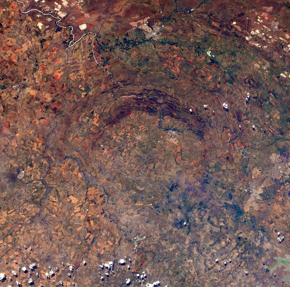
Vredefort with it’s arc of hills. The semicircle has a diameter of some 25 km. Source: ESA
The dispute may seem surprising to us, as the evidence for an impact origin was actually quite strong. But remember, up to the 19th century it was not known that stones could fall from the sky. Then in 1803, a meteorite broke up over L’Aigle in Normandy and showered the town in some 3000 fragments. Jean-Baptiste Biot investigated and found that the physical and oral evidence agreed: these stones had fallen. But to go from there to the idea that those stones from the sky could create geology remained a step too far. There was no need to call upon the heavens to do things the Earth was perfectly capable of itself. There were enough other processes that could cause ring-like structures: volcanoes, intrusions, erosion. Even the obvious impact craters on the Moon were long attributed to volcanism.
The scientific dispute blew up in 1980 when Luis Walter Alvarez and co-authors argued that the iridium anomaly of the time of the dinosaur extinction had an extraterrestrial explanation. He was already a Nobel-prize winning scientist who had worked on the Manhattan project, but he was not a geologist. It was seen as an unwelcome intrusion in the field and the arguments became emotional, personal and at times vitriolic. The argument about continental drift seemed little more than a minor disagreement in comparison.
The discovery of the smoking gun in 1990, when the predicted crater was discovered, tilted the discussion towards acceptance, but this was after Alvarez had died. The discussion now became about what had made the dinosaurs susceptible to extinction by impact. This is of course a valid question, but the strength of the impact hypothesis is such that any other cause was now seen as secondary to the extraterrestrial killer blow. It showed us that extinction events can happen to anyone, anywhere and at any time. But emotions still run high. A recent as the 1990’s, impacts were rarely covered in geology textbooks.
It was against this background that the discussion took place whether or not the Vredefort dome was an impact structure. The defining characteristic that identifies a structure as originating from an impact is the presence of shocked minerals. A falling mountain that impacts with a speed of over 10 kilometers per second creates extreme pressure. This gives rise to minerals such as stishovite, an extremely hard form of quartz that has only ever been found in meteor craters. Planes of deformation inside minerals are another telltale sign of massive shocks. Shatter cones are also an important sign of impacts. They are rocks with lines that form a cone shape, with the top of the cone shape pointing towards the centre of the impact. They require high shock pressure, but not as high as some other minerals: they can also form in nuclear explosions (something else not commonly considered in geology). Shattecones are widespread in Vredefort.

Planar deformation inside a microscopic mineral. Source: Earth & Life, McCarthy and Rubidge, 2005 (Struik publishers)

A shatter cone. Source: Bevan French, Traces of Catastrophe. https://www.lpi.usra.edu/publications/books/CB-954/CB-954.intro.html
All this evidence for Vredefort had been known by 1978, and in hindsight it was compelling. But geologists take their time – after all, they work on geological time scales. And there was a commercial angle. The gold fields of the Witwatersrand also ran in an arc around Vredefort, albeit much further out than the Vredefort dome. When money talks, scientists become cautious and are wont to stay away from disputes.
But the data spoke loud and clear, and by the mid-1990’s the Vredefort dome was largely accepted as an impact structure, with an age of 2.023 billion years, give or take a few million years. The accuracy of the dating is remarkable. Clearly, the land itself must be even older, and indeed it is: the basement rock here is 3.2 billion years old. The Bushveld complex which gave rise to the mineral riches and lies east of (and not within) the impact structure is older, and lived through the impact. So did the gold deposits.
The gold mines are spread over a region called the Witwatersrand Basin. The Witwatersrand is a 200-meter high plateau, 100 km long and 40 km wide, which runs from a bit northeast of Johannesburg to the southwest. The name is used both for the plateau itself and for the steep escarpment on the north side. The Witwatersrand Basin lies to the south of this and is a larger region: this is a sedimentary basin which was a shallow sea around 3 billion years ago, when the gold became deposited. The Cradle of Humankind lies within the basin. The Vredefort Dome is at the centre of this basin, although the two were not related: the impact came many hundreds of millions of years later. The gold mines are largely along the Witwatersrand at the edge of the basin,

The Witwatersrand Basin. Source: Tucker et al., A Review of the Witwatersrand Basin, Episodes, 39, 104 (2016)
Size
The Vredefort Dome is an uplifted area, 50 km across. (Erosion has long removed the uplift, so now it is an area where the deeper granite rocks have come to the surface.) Around this dome is a collar with a diameter of 80 km, consisting of younger rocks: sediments and lavas. This would seem to be the limit of the original crater. But there are larger concentric features as illustrated in the figure. How large really was the original crater?

Source: Tucker et al. 2016
To answer this, we must look at how impact craters, especially very large ones, form. But first, let’s have a look at the region.

Source: https://www.vdome.co.za The river is the Vaal.
The arc of hills around Vredefort look remarkable in the images. They consist of sandstones, not surprising in a sedimentary region. But where in the general region the layers are approximately horizontal (although there is a bit of a tilt), in the hills the layers are nearly vertical. Originally this was several kilometers below ground, by the way. Everything higher up, including the crater wall and bottom, have been eroded away. Something upended these rocks and only these rocks, while deep underground.
There are quarries near Parys, within the uplifted dome. They reveal granite – this is after all uplifted granite. The image below shows a side of the quarry. The light grey granite on the left is the original base rock which formed 3.2 billion years ago and was tens of kilometers underground. At the centre and to the right is a different band of rock where the granite is broken and surrounded by a dark, smooth rock. The second picture shows a close-up of this. The pictures are from Mike Gaylard.


The black mass is glass. It is called pseudotachylite – the ‘pseudo’ part is because this should be a volcanic rock but Vredefort is not volcanic. The pseudotachylite formed when the shock from the impact pass through the granite rock, and melted it. The shock melt formed the dark rock; the granite blocks are the broken-up granite that fell into the melt. All this happened deep underground.
There is another melt type. When the crater formed, it became filled with lava which formed a melt sheet. This sheet is long gone: it has completely eroded away. But immediately after the impact, the ground was deeply fractured and the melt flowed down into those cracks. This formed deep dikes and those can still be seen. This is called a granophyre, and if you have never heard of that, join the crowd since it is rather rare. Some of the granophyre has osmium/rhenium isotopic ratios which appear to come from the object that created Vredefort, so the granophyre is in part extraterrestrial. The pseudotachylite is pure terrestrial granite.
How large was the crater? The granophyre is found only close to the impact centre, out to the ring of hills, within around 25 km of the centre. The ‘planar deformation features’ are seen as far as 45 km from the centre. And the shattercones are found out to 90 km, which is not far from Johannesburg. This has been taken as the size of the original crater, giving it a diameter of 180 km.
Again, it should be pointed out that this is not the crater itself: there has been between 6 and 10 kilometers of erosion. We are looking deep underneath the original crater. This is the reason Vredefort is called an impact structure and not a crater, as the crater is long gone. That makes it hard to define where the original crater ring was.
Shape

Cross section of the original crater. The dashed line shows the current level of erosion: everything above this level is gone. Source: Earth & Life, McCarthy and Rubidge, 2005 (Struik publishers)
Craters come in four different types, depending on size.
A crater up to a few km is called ‘simple’. It has a bowl shape and an outer ring and that is it. Tswaing is of this type.
Between a few and perhaps 20 km the crater is called ‘complex’. It has a shallower, flat bottom rather than a bowl, and has a central rise caused by rebound after the impact.
Eventually, the central peak becomes a central ring. The crater is now called a peak ring crater.
The larger the crater, the larger the central ring. Eventually this ring approaches the outer ring and the crater is now called a multi-ring crater. The diameters where the craters change type depends on the local gravity (it is different on the Moon and on Earth and also depends on the type of surface (rock or mud, for instance.)
(Strictly speaking there is a 5th type which is the first. These are the pit craters that are created when dust particles hit a surface. They only form in vacuum and have sizes of millimeters or less.)

Source: https://clrn.uwo.ca/clrn-research/impact-crater-formation-and-morphology/
There are only three multi-ring craters known on Earth: Chicxulub, Sudbury and Vredefort. In all these cases, it is hard to know whether the outermost mapped ring is or is not the outer ring! For Vredefort, it appears not to be. The true diameter of the original crater is thought to be 250-280 km. That makes it the largest one on Earth, just beating Sudbury. There is a fragment of an arc of the granite base rock found far to the northwest – if that is from the original crater rim, then it reached 300 km diameter.
Why is there only half a structure left? The structure is visible in the north, but the southern half is not seen. Actually it is seen in gravity measurements, but it is buried. The reason is the Karoo flood basalt (already mentioned): it covered the southern half, and the weight of the lava depressed the region. Just wait a few hundred million years. By then, the northern half will be eroded away but the southern half should appear.
What kind of impactor could it have been? A useful rule of thumb is that the crater is 20 times the diameter of the object that caused it. That is not a law of physics: it depends on what kind of surface was hit. But it gives a reasonable idea. That makes the Vredefort rock 10-15 km diameter. It was bigger than Mount Everest. Imagine Mount Everest falling down on your favourite location on Earth. It was like that.
Impact
It was worse than that. The mountain came down with a speed of some 15 kilometers per second. It passed through the atmosphere in mere seconds. Earlier, while in space, it would have been visible by reflecting sunlight. At a distance of 3000 km, it would already have been as bright as the moon. And well before it would have been easily visible at night to the naked eye – at least if it didn’t come in from the direction of the Sun. Even at the distance of the Moon, it could have been the brightest star in the night sky. That may have been one to a few days before the impact.
Asteroids tend to move on orbits that are not much faster or slower than the Earth, so the relative velocity was likely small, a few km/s. (Ok, that is fast for geology, compared to, say, continental drift.) As it moved closer, it came under the influence of Earth’s gravity and started to move faster and faster, falling down. At a distance of 3000 km, impact was only minutes away. At 200 km it began to feel the atmosphere and by 100 km it had formed a bright fireball, burning the ground below just from the radiation. Along a track of several hundred kilometres, everything was killed well before impact – or at least it would have, had there been any life there. Less than 10 seconds later, it hit. It was not heard: the impact was before the sound wave arrived because the asteroid came in supersonically, and to the unlucky observer the asteroid would have been seen first, with the sonic boom arriving a minute later being the least of their worries. (The is true even for the Chelyabinsk meteor where most injuries came from the atmospheric sonic boom arriving a minute later. If you see a large meteor, stay away from windows for the next two minutes.) (But don’t worry about this if it is an asteroid.) If the observer was able to continue observing, they could have heard the asteroid safely moving away from them – because the sound from the more distant, earlier parts of the trajectory arrived later.
The impact was extremely energetic. The shaking was equivalent to an earthquake magnitude 14. (I don’t know what that feels like either. Very roughly, at a distance of 10 km, objects would be thrown into the air with a peak acceleration of 10g.) At a distance of 300 km, the earthquake would arrive after roughly a minute. Ballistic rocks thrown out by the impact arrived shortly after. The atmospheric shock wave arrived after 5 minutes. But the radiation from the rising fireball of the impact got their first, moving at the speed of light.
The underground explosion blew a rapidly growing hole in the Earth. The explosion occurred kilometers below ground but it did not penetrate into the mantle. The rebound was from granite from deeper levels in the crust, not mantle material. That would take an impact even larger than Vredefort.
The approximate sequence of events is shown below. This is taken from an old simulation of a large impact (not as large as this) hitting Berlin. (It was made by German scientists eager not to endanger the rest of the world.)

20 seconds after impact, the hole is growing and ejecta are spewing out from the side of the growing crater. The expansion continues for two minutes. By that time, the ground at the centre of the crater, which was pushed down by the force of the explosion, is rebounding and just like a drop of water falling in a bath, creates a central bulge. In a complex crater, the rebounding bulge solidifies at this point to form a central peak, but in a very large impact this rebound itself falls down again and in a second rebound will create a ring around it – the inner ring of what will be a multi-ring crater. The crater at this point may still be expanding.
As the deep crust is pushed down, it will in return push the ground much further out upwards. This combination creates a central bulge (the Vredefort dome), the deep crater around it, and around that a higher rim from this outer uplift.
Matter that is evacuated from the crater flies through the air. Much of it is fragmented rocks, although ‘fragmented’ should be taken with a grain of salt. Rocks that themselves would be decent-sized hills are thrown hundreds of kilometers distance. They are joined by much smaller fragments, down to dust. It creates a blanket around the crater which even 500 kilometers away is still 100 meters thick. Other flying material comes from the melt caused by the asteroid. These droplets rain down on top of the debris layer as minute glass-like spherules. They come in two forms, fragments that are ejected in ballistic trajectories and fall back down from space over several hours, and ones that drift in the atmosphere and are carried by wind – lots of wind after such an impact. The ballistic droplets may fall down thousand of kilometers away. The entire world was hit by a Noachian deluge of rock and glass.
But perhaps most damaging was the heat released by the impact. The spherule rain would have heated the upper atmosphere to a temperature of 1000 K. The radiation from this would be as strong as 10 times the radiation of the midday sun, comparable to an oven. The air temperatures, especially in dry air, are less affected by this one-hour heat pulse, but any surface exposed to the sky would be baked.
Remains of the day
These events happened long ago. Erosion has removed the rim, the crater with its melt sheet and the inner ring, as well as all ejecta. What we now see is the granite dome, the bit of the uplift which stayed below ground and which is surrounded by younger material (where the ground was flexed down), and another outer ring where deeper material has come up. But what was at ground level 2 billion years ago is long gone. Don’t expect to find spherules here!
But millimeter-sized spherules from Vredefort have been found, just not in South Africa. They were found in a 10-cm thick layer in Karelia, north Russia, with spherule shapes indicating that some came in from space rather than wind. Both the age and the composition point at an origin in the Vredefort impact: the iridium, platinum and various isotopes indicate that they are from an impact and are not volcanic. Russia is a world away, 10,000 km from Vredefort! But of course, the world was different in those days and continents were not where they are now. Models of the impact indicate that a 10-cm debris layer could have formed as far as 2500 km from Vredefort. Clearly, Russia (or better, the fenno-scandinavian shield) was much closer to South Africa in those days, but this is still a long way apart.
Spherules have also been found on the southwest coast of Greenland. Their date is more uncertain and they could come from either Vredefort or Sudbury. But the chemical composition is different from Sudbury and points at Vredefort. The layer containing the spherules is one meter thick and extends over 25 km. The layer appears to have been deposited below water, by high-energy waves or a debris flow which also deposited rocks up to 1 meter in size. It is tempting to associate this with a tsunami induced by the impact. The Vredefort impact itself was on land, but the pressure wave would still have whipped up the oceans into a frenzy. However, this is speculative. The region can also have been destabilized by the massive earthquakes caused by the impact which would have rocked the entire world. The Earth would have rung like a bell for weeks.
The layers below and above the spherule layer are a bit different from each other, indicating a change in the ocean chemistry. This could have been caused by a lot of continental debris entering the ocean but this also remains speculative.
Life
We know very little about the impact on the rest of the world. Nowadays, such an event would be devastating worldwide, as was the case of the Chicxulub event which was smaller than Vredefort. Imagine the entire world on fire! But 2 billion years ago, the continents were lifeless and without life there can be no fire. The dust from the impact would have dimmed the planet for anywhere from a decade to a century. Sulphur may also have been released as the impact hit an old sedimentary basin, though deeply buried at the time, causing additional cooling. This was counteracted by the sheer heat from the impact. But the oceans are more resilient than the land and take much longer to cool down. There is no evidence for a mass extinction at the time, but this means little, seeing how limited the fossil record from this age is.
We do know that life survived. The Earth was devastated, but not destroyed. There would have been a difficult decade for bacteria, algae and other single-cell life forms, but they pulled through. How many did not make it, we may never know. Stromatolites would have been destroyed but they re-established themselves. But if any multi-cellular life forms had developed (something we don’t know but possible), those did not survive and they had to re-evolve.
Gold of Humankind
South Africa is an amazing country. Within a relatively small area it has the Bushveld with the richest mineral deposits in the world, the gold fields of the Witwatersrand responsible for 30% of the gold mined in the world, and the largest impact structure known on Earth. And of course there is the Cradle of Humankind with the remains of ancient Mrs. Ples and 30% of all other known hominid fossils. Is there any relation between these?
Mrs. Ples and Vredefort are 2 billion years apart, so this coincidence seems coincidental. That Mrs. Ples was aware of the gold and platinum also seems unlikely. The Bushveld intrusion happened shortly (50 million years or so) before the Vredefort impact but we know that the two were unrelated. The intrusion is outside of the original crater but some dikes intrude into the region. Those dikes show the shock impacts, meaning that they were in situ and had solidified at the time of the impact. The orientation of the magnetism in the Bushveld intrusion also shows that it predates the asteroid. So this was coincidental. It is just that some countries have all the luck.
But how about the gold? Why are all the goldmines located in a semicircle around the Vredefort dome? And it is indeed all the goldmines: a third of the world’s gold comes from the Vredefort crater ring. The map below shows the goldmines in blue. How can this be accidental? The gold itself is solidly terrestrial, though. It was put done many hundreds of millions of year before the impact. Do asteroids hunt for gold too?

The Witwatersrand basin. The gold mines are shown in blue
The answer is a bit more down to earth. Remember that some of the regions were pushed down by the impact, and some regions came up. The outer rim and central dome came up, and the main crater went down.

This image shows the effect, The reddish colour depicts the deep granite base rock. The yellow layer is the one that contains the gold. This layer was bend upward near the outer edge of the crater. The black dashed line shows the current surface level. The gold mines are located where the yellow layer approaches the current surface. There is probably much more gold elsewhere in the layer, but it is deep underground and we can neither find it nor mine it. It became minable because of the uplift by the Vredefort impact, the 6 to 10 km of erosion in the two billion years since – and because of other accidents such as the fact that the Karoo flood basalt left half the impact structure uncovered.
You may note that the yellow layer also reaches the surface near the centre, immediately around the Vredefort dome. And indeed, there are some gold mines in the hills around Vredefort. But the gold veins are much more broken up here and are difficult to find and follow underground, so the mining was abandoned here a century ago.
The twist at the end
There is a final twist. The gold deposits are located in a layer of sediment that formed in shallow water. The sediment is not just gold: it is mainly limestone deposited in a shallow warm ocean, as is found in many places around the world. Limestone dissolves in rain and forms caves. The hominid fossils of the Cradle of Humankind were found in those caves.
Hominids -us included- have always been attracted to shallow caves. Just look at how we build our houses which resemble large, airy caves with a view of the outside so we can see the neighbours and other threats. The Cradle of Humankind is there because of the uplift of this sedimentary layer by the Vredefort impact, and the fossils survived because they were protected inside those caves.
There is a relation after all: The Vredefort impact built us our first homes. Caves as safe as houses.
Legacy
The Vredefort impact has left a lasting legacy in South Africa. The impact shaped the country and made much of its wealth accessible. It may not be immediately obvious on the ground and it takes effort to see the signs of the event, but it is well worth that effort. This designated world heritage site is one of the wonders of the world, albeit a scary one.
If an event like this were to re-occur, humanity would go the way of the dinosaurs, and would do so in the way of the dinosaurs. Vredefort helped create us, but it also shows us our fragility.
Albert, June 2025

Source: https://www.vdome.co.za
Normally there would now be a set of papers or reading list. Instead, there is a link to a youtube presentation by one of the main researchers working in the field (literally so, in this case). You will find a good overlap with the post, and for good reason. You may even recognise some of the figures.


Marvelous read Albert!
I suspect that, if Elon has his way, that we will be finding bits of South Africa on Mars, as a result of the Vredefort impact. We already have been finding bits of Mars on our planet, which had been blasted from the Martian surface by bolides.
Bravo Zulu!!!
Excellent! Thank you so much!
Thank-you to the introduction to the gold Armageddon 2 billion years ago!
What kind of rock was the yellow “Witwatersand Supergroup” that contained gold? Was it some kind of metamorphed rock in the neighbourhood of intrusive crystalline Granite rock?
It is mainly marine sedimentary, with sand, shale, pebbles and as mentioned some limestone. It is a thick layer deposited over a long time, so there are a range of compositions. There is even a layer from an ancient glaciation. The gold deposits are mainly associated with sandstone. The limestone of the hominid fossils comes from the Transvaal supergroup, green in the figure, which is a bit younger but still formed before the Vredefort impact. It survived because of the downward flexure in the crater.
How did the gold come into this sediment? Was there a gold source in the mantle or a rift that caused a high concentration of gold inside an intrusion? I imagine a relatively gold rich crystalline craton, from which the sand was eroded that built the gold sandstone. What chemical process does usually enrich gold in rock?
This was discussed a little in the post about gold. (That one, the komatiite post and this one were meant to go together.) The gold must have come from a mountain range. Why this particular gold deposit is so rich is a good question. It probably has to with the age. A big question is how it survived, which this post tried to answer. The fact that it seems to have been a pure cosmic accident suggest such deposits were not uncommon in the first cratons. The others have not survived or have become buried too deeply.
Iceland: Deformation of Svartsengi gets close to the level in end of March. http://brunnur.vedur.is/gps/eldfjoll/reykjanes/SENG-plate_since-20231112%5B.%5Dpng
http://brunnur.vedur.is/gps/reykjanes.html
Has the volcano recharged faster than expected for the next episode?
Hi Albert. I spend too much time on google earth but suggest that Lac Wiyasasakimi in Quebec may be classified as a multirim crater. Interstingly it looks like it may had a twin body that impacted just to the south. Very heavy glacial erosion in that area. Great article. Spent some time around Sudbury. Very interesting impact features to be seen everywhere
I feel like we could use an asteroid right now.
If it helps to produce gold, the people with gold fever would agree.
I like that: “Do be aware of snakes in the surrounding fields.”
Boomslang. Pretty. Very deadly.
Darth Vader
(Cape Cobra)
One question: I thought so far that the “Cradle of Mankind” was in the African Rift. ?????
Mankind has more than one cradle. I guess that is one reason this was renamed cradle of humankind.
I stepped on a cape cobra once. Or at least, tried to. It ran off just in time, or whatever it is that a snake in panic does. Never seen a boomslang but you wouldn’t expect them in dry bushland.
I would take that, but only without the map 😒: “It is a small town some 120 km south-southeast of Johannesburg.”
It is south-southwest on that map.
Thanks, I always get this the wrong way around in the southern hemisphere. I’ll get the town moved
Maybe it is because you are looking in the sky too much.
Webcam V2 shows the tephra slopes in the SW bay of the caldera: https://www.youtube.com/watch?v=fiyttmA7YkA
They could use it for a summer tephra skiing event. Has it ever been tested on tephra? The slope of the SW tephra hill is steep enough to allow some speed downhill. In Namib(ia) they did sand skiing: https://en.wikipedia.org/wiki/Sand_skiing
Do the episodes currently push out old/viscous magma like the 2018 LERZ eruption did first? The first weeks of the Puna eruption had old magma that didn’t flow far from the vents. It was too cool to flow fast anywhere. Here we see a typical fissure during these first weeks: https://www.youtube.com/watch?v=yvUa1QQpVnc
Before the spectacular part of episode 25 2025, this video shows the lava that ran out on low scale. The lava looks to me a bit more sluggish than the normal hot lava. Was it a cooled magma that had been drained down in the end of episode 24? https://www.youtube.com/watch?v=dXp_nbgSAhc
I actually thought the E25 early stages looked less viscous… some early episodes had obviously re-erupted lava to start, I think E4 was even almost a’a right from the vent. But that was 6 months ago, there is minimal if any drainback into the vents at all now.
It is possible the viscous appearence is because of the lava being a foam, the liquid is probably close to olive oil
https://m.youtube.com/watch?v=wceLE0gHs6U&pp=ygUdZmFncmFkYWxzZmphbGwgdmFsZW50aW4gdHJvbGw%3D
Fagradalsfjall during high summer 2021 also developed ultra fluid olive oil viscosity lavas this lava looks alot like Kilaueas lava cascades when a fountain is about to burst into a lava geyser episode
I’ve seen ‘boarders’ on Cerro Negro-Nicaragua in the past. I can’t imagine that pumice does the boards’ finish any good.
That seems to be the main location for the sport. I wouldn’t recommend it but it seems to be popular with tourists
“The scientific dispute blew up in 1980 when Luis Walter Alvarez and co-authors argued that the iridium anomaly of the time of the dinosaur extinction had an extraterrestrial explanation. He was already a Nobel-prize winning scientist who had worked on the Manhattan project, but he was not a geologist.”
No, but his son, Walter was the geologist. He probably found the site first and then went with his father and two Nuclear Chemists from Berkeley, Frank Asaro and Helen Michel, who could use the Lawrence Berkeley Laboratory.
It is probably the discovery of Walter, the geologist, whereas his father did the labatory work with Asaro and Michel.
Ref. to passage about Chicxulub
You wrote, Albert, that Witwatersrand was a “shallow sea”, and the add that the Vredefort structures were deep under ground and were uplifted. This makes me wonder about the “shallow”. Maybe it was not shallow, but old and deep, so there was subduction which uplifted the impact crater. That seems at least logical to me.
It occurred over a long period of time. It was not a subduction zone, at least the sediment wasn’t subducted. The depth of the sea would have varied with location and time. The gold was deposited in the shallowest part. The limestone was a later addition, although still older than Vredefort. Vredefort added a melt sheet which later protected the older layers. At the time of the impact, the area was land. But continental plates do rise and fall with the phases of plate tectonics. Sediment eventually forms dry land. Dig down just about anywhere and you may find amazing histories. Most history is from times when the land is submerged, because that gives sediment while dry land often just gives erosion, erasing the history.
“Clearly, Russia (or better, the fenno-scandinavian shield) was much closer to South Africa in those days, but this is still a long way apart.”
I was unable to find an map for the time, but it might have been even closer than here which is 550 Ma:
Also:
which brackets the age of the 2020 Ma Vredefort impact structure in South Africa, and suggests that the spherule beds could represent ejecta from that event. If the link is confirmed, the size of the spherules and thickness of the beds suggest that the distance from the impact site was <2500 km, thereby constraining the paleogeographic distance between the Fennoscandian Shield and Kaapvaal craton during the late Paleoproterozoic.
https://pubs.geoscienceworld.org/gsa/geology/article-abstract/42/5/375/131492/Impact-spherules-from-Karelia-Russia-Possible?redirectedFrom=fulltext
no full text available, sorry
Now I wonder what speaks against Vredefort being a part of the Fenno-Scandinavian Shield back then and breaking apart later. So much broke apart all the time, so much did considerable travelling as continent or terrane. And what is highly telling (maybe) that there is abundant Gold in both South Africa and Siberia, more than elsewhere as far as I know.
Then the African Continent will be sending the Somali Plate off one day and has lots of fractures, so seems to be prone to fracturing and reassembling.
We don’t know where the cratons were located more than a billion years ago. Vredefort is the only evidence we have that Fenno-Scandinavia were no more than 2500 km apart – probably. The layer in Greenland was thicker and at face value that would have been even closer, but it was emplaced in water by a debris flow, so the thickness may not reflect the actual fall. Siberia is another craton, by the way, not related to either.
Yes, and Ron Blakey who I think was the first to do paleographic maps for the Am. west advised caution, considers them models based on Chemistry, Physics and Logics. He said though in the foreword of one of his books that things might be a little different, and the further we go back the more imprecise they might be.
Concerning that subduction theory of mine which you rejected you are right as there is no sign of any island arc built into that area.
Interesting piece, made my Saturday even better, thanks Albert. Have a nice Sunday (everybody)
Here is some about Walter Alvarez, the Geologist, son of Luis (Walter) Alvayez, the physicist and Noble Prize winner:
Gubbio you wonder. This results from his interest in archeological Geology which led him to Italy to study volcanics there. Then he might have found Gubbio already.
Crater, Catastrophe, Contingency:
An Improbable Journey and the Human Situation:
A Review of Books by Walter Alvarez
Barry Wood
University of Houston
https://jbh.journals.villanova.edu/article/download/2407/2327?inline=1
That is very interesting. The impact reminded me of the Carswell structure here in Saskatchewan.
Here, it is much boring than South Africa, especially post-Cambrian, save for whole seas and glaciers (and a few kimberlites around Prince Albert), and this. Ages are very uncertain from what I’ve heard, like the 115 million year mark given by Google, whereas some state 478 million years and even fewer estimates being older. Either way, the impact itself brought up uranium from the Athabasca Basin, just like how Vredefort brought up gold. The mines extracted that uranium to power power plants and, in the past, some might’ve went to nuclear weapons.
From: https://www.academia.edu/8267141/The_Carswell_impact_event_Saskatchewan_Canada_Evidence_for_a_pre_Athabasca_multiring_basin
Kilauea already half way recovered from E25, 7 microradians in 3.5 days, 2 per day. The amount of lava erupted in E25 was 5.3 million m3, so the supply rate is about 0.75 million m3 a day by direct comparison.
The volume is 112.6 million m3 based on the HVO records.
https://www.usgs.gov/volcanoes/kilauea/science/eruption-information#overview
Based on that volume, the average output is 0.7 million m3 daily. But this includes the net deflation of E1-E3, which erupted 27 million of that total. Removing that part, gives 85.6 million m3 in 163 days, or only 0.52 million m3 daily. So the supply rate now really as increased.
New unrest on Santorini, the same line as in February/March, but below the island: https://www.volcanodiscovery.com/de/santorin/news/273546/Santorini-volcano-Greece-new-swarm-of-small-earthquakes.html
If the earthquake continue to migrate on this line towards SW, they may reach to Kameni (the “Anak Krakatau” island of Santorini).
They have a report about the last eruption 1950: https://www.volcanodiscovery.com/santorini/1950-eruption.html
It was mainly a lava dome eruption with preatic explosions. The lava dome grew horizontally like a slow lava flow.
Summary of 20th century eruption history: https://www.santorini.com/santorinivolcano/volcaniceruptions.htm
The previous eruptions began with phreatic/hydrothermal activity and sinking/upheaval of land.
Usually the old rocks like these in South Africa are buried. They need some kind of uplift, so that erosion can dig to the continental roots. You mention the divorce from Antarctica 180 million years ago (Jurassic Age). Often a divergent plate boundary or rift causes sinking of the rift valley or new oceanic floor, while on the flanks of the rift zone there is a upward counter-movement of the land. What is the reason that uplifted cratons like this stay high long after the continental divorce?
Old cratons tend to lie 300-500 meter above sea level. They have thick granite crust which provides the buoyancy. But as you say, there are other effects that can change the altitude. The interior of South Africa is much higher than that: it has been rising over the the past 5 million years
Probably pushed up by the same process that split the continent further north. South Africa might be adjacent to the next flood basalt, although likely still not of the scale of those which fragment supercontinents.
I dont know if this is still the accepted model, but I last heard that the abundant dolerite of Tasmania, which caps my local mountain, is part of the Karoo LIP. If there was surface volcanism is unknown but I suspect it is highly likely. Tasmania though even in the Gondwana days was still on the other side of Australia from where South Africa was, 3000 km away, and Madagascar and India were probably somewhat in the way too, so the Karoo was only a part of a much larger whole, it would seem.
The crazy part is really that life didnt seem bothered by the event much. Physically yes but it wasnt an apocalypse beyond its boundary. Theres no fossils after the early Jurassic in South Africa (I think, excluding much newer late Cenozoic) but many of the animals found at Dinosaur Cove in Victoria, Australia, which was in the now old rift valley, a few of those were straight up relics of the Triassic, and the dinosaurs known are often pretty basal to those of similar age on the northern continents, or at least thats how our interpretation of them is anyway.
The ‘relic’ mentioned above, Koolasuchus cleelandi.

Looks cute but it was bigger than most crocodiles, and frogs with similar mouths will eat anything that fits in it…
This is the cute version caught a few weeks ago in Austria, a “Bergmolch”. 😁
Ichthyosaura alpestris
Well, the shape of a newt is basically just the default state of all tetrapods, so not surprising the resemblance 🙂
That thing looks creepy…
Cute. Totally harmless creature, Tallis.
Must be a female Tallis (We are ugly, you guys fall in love with Estee Lauder etc)
Two males:
3 metres, just about.
Sharp teeth, aquatic predator.
Mosasaur would have loved to feed on him, bitMosasaur came about 40-50 million years later. As a fossil he looks cute indeed
Heh, fine name:
Bolg amondol: New monstersaur reveals complex evolutionary history of giant Gila monster relatives (Phys.org, 17 Jun)
Here’s Bolg:
Pretty fascinating. Original publication:
https://royalsocietypublishing.org/doi/10.1098/rsos.250435
Africa is a continent with lots of old cratons. The coasts are usually rocky, not flat. That’s different to parts of Europe and Northamerica, where continental periods and maritime periods alternated.
Cratons are pretty evenly distributed as you will see in the list.
https://en.wikipedia.org/wiki/List_of_shields_and_cratons
If you want a front runner though I suggest North America:
I have no idea though who the heck showed this to Donald Trump.
North America’s Craton was in geological history flooded occasionally:
Cretaceous to early Paleocene: https://en.wikipedia.org/wiki/Western_Interior_Seaway
The craton lies a bit deeper than Africa’s cratons, so a flat landscap and prehistorical maritime conditions were possible.
I think that might be too simple, kind of static thinking. 100 Ma there is no California. California is swimming in Panthalassa/Pacific Ocean.
Basin and Range Province plus Western Utah is island arcs.
Then you have the back-arc basin and the beginning Rockies. That ominous Western Interior Seaway might be the back-arc basin and wider, under where the Rockies are now and reaching into Kansas which was, according to fossil findings, the other bank.
Where the Craton ended is not that clear, and the whole continent was significantly further east.
There was water (lots) where the Farallon Plate subducted, but in this area there was certainly no craton. The craton must have moved west while the Rockies where risen from the subduction process.
South America is much clearer may serve as a model.
North America has many question marks and is only partially understood.
https://m.youtube.com/watch?v=ERMDerlleOw
https://m.youtube.com/watch?v=DBm_D_tsWMw&t=26s
Very nice videos part 1 and 2 showing exactly how its like to descend into the abyss of a Gas Giant / Ice Giant. This is to be honest absolutey terryfying and fascinating. Part one 1 is a good introduction video
Daydreams of roaming Jupiters upper troposphere… The upper atmosphere like saied of the gas giants like Jupiter are a pilots dream…. to be honest endless endless landscapes of fluffy huge white clouds.. looking like fluffy white floating mountains rise from hazy depths under a marine blue sky… stretch to the horizon.. with no solid surface below …but whats below is rather disturbing
Daysky color depends on depth how deep you are in Jupiters bottomless atmosphere the more air pressure the paler the dayskies above your head becomes due to light scattering. ( bottomless pit! ) It also much deeper down it gets darker and darker the further down you go due to molecular scattering blocking light ( and clouds above )
Very high up on Jupiter (1/100 th ) of Earths surface pressure you woud see a nearly black daysky ( very little light scattering ) with an intense white sun
When you descend to an air pressure level ( 1/10 th ) of Earths surface pressure you starts to see a dark marine blue daysky due to the hydrogen getting dense enough for some weak scattering
At an air pressure level similar to Earth you will see a familiar sky blue earth sky
At 2 Earth atmospheres pressure the sky becomes ligther and paler light blue
at 4 Earth atmosphere pressures the daysky maybe a pale turqouse with a yellow distant sun.
At 10 Earth atmosphere pressure depth the daysky maybe a white pale with an orange sun
At 20 Earth atmosphere pressures the Jupiter daysky have become pale grey
Further down into Jupiter or any giant planet it gets as dark as night… 🫣 as the sun simply cannot shine through so much air molecules … and it gets hotter and hotter the deeper you go
You will likey be in the first upper frozen cloud layers already at 2 earth atmospheres…..at least for Jupiter
Ljosufjoll M3.72
Still very deep. Long way to the surface and eruption if it moves that way!
Plus several smaller quakes at 1km and 5km.
Looks quite interesting !
Good reason to postpone that asteroid for now ..
Bravo!
Just a quick reminder: When in Iceland, remember to check the quality measure for the listed quakes. Those that are not listed as 99 have not been manually checked and cannot really be trusted. Anything below 90 usually has quite poor precision. In this case, all verified quakes are at depths deeper than 15km.
Also remember that if quakes do happen at shallow depths, it doesn’t mean that magma has reached that depth. As far as I know, there have been no reports of ground deformation measured by GPS or InSAR. This means that whatever is going on is still happening very deep below.
Speaking of Iceland. They somehow managed to lose the Bárdarbunga quake that happened in May from their database. They first had it reported at M4.8, but then changed their mind and said in the news that it actually was M5.3. IMO even posted that number in their specialist remark. Shortly after they announced that the magnitude was M5.3, it disappeared completely from the list. It’s still not included in the Skjálfta-Lísa database. I suppose someone went in to edit the details, but somehow managed to delete it instead of saving it. I thought that someone would have noticed by now and restored it, but that still hasn’t happened.
Maybe they relocated it to Russia? Easy to lose a quake if you accidentally edit the coordinates
That’s, of course, always a possibility 🙂
“Tallis Rockwell
14/06/2025 at 15:32
I feel like we could use an asteroid right now.”
Yes. 😞
It would certainly be a “kinder” ending than what is to come.
Kilauea cross-caldera GPS plot shows the distance between UWEV and CRIM is the same as when the eruption started, when the dike opened it pushed them apart rapidly then the caldera contracted as the eruption began. CRIM has slightly subsided individually, but UWEV has not, and it is pretty clear that although no magma is going outside the summit the eruption hasnt really relieved any pressure, the eruption rate is entirely dominated by the deep supply rate from the mantle, it could go on for years or even decades at this rate…
The Strombolian eruption (occasional spattering) has begun: https://www.youtube.com/watch?v=oG5zz9Sjw3E
An image with the tephra hill and the possible exit of lava, if the shield volcano grows beyond the caldera rim: https://www.usgs.gov/media/images/june-16-2025-view-kilauea-summit-tephra-deposit-after-episode-25
On that note, they have shared the most recent map (as of June 13th). Oddly enough, they show the lava volume as 101 million m³. Maybe they are not counting the tephra…
Yes I found it strange that the map is so far behind the same data on their own site. This map didnt include E25 but its still pretty far off. If the difference is tephra though then there is about 6 million m3 outside the caldera, so a VEI 2 bare minimum.
After long time a Mauna Loa tilt finally shows an upward trend:
A real inflation or falsified data by weather and other disturbing influences?
Lewotobi had massive eruption today.
Cool beans, getting Ruang flashbacks.
One thing the recent Reykjanes Fires didn’t do was an “amphibious” fissure eruption. I mean a fissure that begins onshore and extends offshore. So effusive onshore and explosive phreatomagmatic offshore. Both Fagradalsfjall and Svartsengi erupt too far in the inland to do this. The only possibility is a fissure on Reykjanes end (in Scandinavian languages “odde” https://en.wiktionary.org/wiki/odde), but the system there hasn’t erupted yet.
Kilauea’s LERZ did sometimes offshore Surtseyan eruptions on the extreme northeastern end. The fissures 1960 and 2018 were too high onshore to get any phreatomagmatic behaviour. Is it in possible that a deep LERZ eruption happens in the area, where the rift zone crosses the shoreline?
1960 certainly was phreatomagmatic early on–didn’t create a tuff cone like the prehistoric Kapoho Crater, but it was spectacular.
Heh. I found this map of 2gya on wiki. Unfortunately, it’s not labelled, but the pieces have modern topography on them! So far, I’ve only identified a couple of them. 🙂
I believe that what we see here is what has been identified. There might have been more land, but it has disappeared, buried by mountain chains, by new oceans or eroded away.
There must be millions of Atlantis.
The model of Pangaea is probably flawed as well. There are scientists who believe there were shallow seaways in Pangaea, and that seems very plausible to me.
We probably know more about shallow seas than about the land, because seas leave sediment and land just does erosion. Regarding the cratons, we really have no idea what bordered what more than a billion years ago. It is too fragmented
By the creature mentioned aboce by Chad and then me comparing it with Mosasaur I stumbled upon the fact that Mosasaur fossild from Africa are mainly from two countries.
1. Morocco which had an inland sea separating it from Africa, and
2. Angola, which made me read about the Congo River with the second greatest basin in the world, the greatest depth (220 m), pondering about the possibility of it once having been an inland shallow sea with salt water. Hard to find out.
But two things were definitely interesting in this small personal reaearch:
The course of the river running precisely around the Congo Craton, first north, then west, then southwest:
And then definitely this fascinating article:
https://www.nationalgeographic.com/magazine/article/congo-river-central-africas-water-highway
Great stuff I swear. Good read for Carl too in case he looks here.
Supposedly, the Congo and Amazon were one drainage on Pangea before being bisected by rifting. The Amazon flowed west until the Miocene when tbecAndes grew too fast to erode through. It backed up into a massive lake system in the Miocene before reversing and draining towards the Atlantic.
Lots of more ancient groups of fish are found in both rivers, like characins, lungfish and arapaima, although only the lungfish are certainly old enough to have existed before the split.
Pangea existed completely for about 100 million years, and incompletely from the late Devonian to the Jurassic, so its very likely to have had variable sea incursion. The very high sea levels in the Cretaceous though were because of rapid separation leading both to smaller continents and large areas of young seafloor, probably also the smaller continents having less buoyancy compared to the supercontinent. Pangea would have been hot underneath pushing it up, so keeping it mostly high and dry. Most of Pangea might have been very similar to South Africa now, actually, at least thats how I imagine it. Obviously there were also other biomes of every sort from jungle to glacier but deserts were particularly big still. The massive proto Congo-Amazon might well have at times been dead dry.
Regarding mosasaur fissils though, Morocco finds them mostly in phosphate mines, so not really deliberately looking so much. Morocco is also much safer than most of the rest of west Africa… There was a shallow sea through the central Sahara but I dont know if it still existed in the Maastrichtian. Africa has always been a very elevated continent it appears, it was the heart of Gondwana so maybe that is related. Although it is probably mostly the mantle upwelling beneath it.
Also chronologically it is much more accurate to have a mosasaur swimming in the modern ocean than in the days of Pangea 🙂
This fits very precisely.
It is parallel to the pushed up Atlas, close to where the inland arm of Tethys or the Atlantic Ocean must have been. Phosphate is a remnant of bones. So, there were many bones in the area when Morrocco had travelled in. And some of them were from the Mosasaur.
Angola, known for diamonds and iron or, also has phosphate: “Angola is also rich in several other mineral resources that had not been fully exploited by the early twenty- first century . These include manganese, copper, gold, phosphates, granite, marble, uranium, quartz, lead, zinc, wolfram, tin, fluorite, sulfur, feldspar, kaolin, mica, asphalt, gypsum, and talc.” en wiki
Angola has a large littoral plane of a width between 50 and 160 km . This is where the fossiliferous
strata are found. And this coastal plain might have been submarine with the higher water levels of the time.
You know what, after thinking about saurs I wrote Denalisaur first, 😂🤣
https://www.bbc.co.uk/news/articles/ckg32p7kv4lo
Regarding that, I wonder if there is any data of the replenishment rates of the soils around the world with volcanic ash? I would guess many islands of Indonesia, Philippines and maybe the North Island of New Zealand (Taupo…) would be on the top of the list, especially if averaged over many millennia?
Anywhere around subduction zone volcanoes must be a good place for that, though I imagine replenishment is faster near very active stratovolcano complexes, particularly Java and nearby islands, and the Central Kamchatka Depression.
It looks like the first sub-Plinian eruption plume 2025. VEI3 or 4?
Thanks Albert, a great read!
Just a question: Do you know the specific place of Karelia where Vredefort spherules have been found? It seems that Karelides mountain chain was about 200 million years younger than the event described here, so I guess farther east from Koli and Finnish border.
On the shore of lake Onega. (The paper actually gives coordinates that are in the Greenland Sea but they got east and west mixed up (and the referees missed that).) (I couldn’t possibly comment, having done the same in this post.)
I admit I once made the same mistake with running a tsunami simulation except mine was mixing + & – degrees north or south of the equator!
(Fortunately it was only during an exercise and the same situation could not arise in a real response as we normally import earthquake data direct from SeisComP into TOAST!)
I guess that made it to the risk analysis.
I know of a space observation where the astronomer put the wrong sign in the coordinates. Hours spend looking at empty sky. Say 100,000 dollars worth. Nowadays we have databases of what coordinates go with what target name, so that risk is now much less.
– astronomer put the wrong sign in the coordinates. Hours spend looking at empty sky. Say 100,000 dollars worth
That is why I examine e.th I read, sometimes twice, esp signs and data.
Not sure if anyone has been watching, but Sundhnjukur is in the danger zone again. Fully recovered from the April 1 intrusion.
The dike from the last eruption was about 31 million m3 including the small amount erupted, so to recover that in 78 days is an average supply rate of 0.4 million m3 a day, or 0.146 km3 a year. Its supply was probably double that in April though, and less now though not low. Its abundantly clear that while not as fast as early last year, the magma supply hasnt really decreased in a significant way, and the fact that last time was mostly an intrusion suggests maybe it is much earlier in the full event than we assumed, it is not a strict rule that this will be like in the 1220s, the magma composition differences and unexpected initiation point already broke that connection. Its also pretty obvious that A LOT more lava has erupted much faster this time than 800 years ago, else the records are much less complete than assumed.
This supply also makes Svartsengi currently responsible for a similar volume of magma as all of the so called ‘real’ volcanoes in Iceland combined… so maybe we are all looking the wrong way waiting for them and ignoring the literal elephant in the room.
None of them compare to Kilauea though, still… Pele is evidently the most powerful volcano deity 🙂
During Medieval Fires Krysuvik had in fact two seperate events: Afstapahraun around 900 AD, and Krysuvik Fires 1151-1188. This shows that it’s possible that the same system does some kind of eruptions first, and a different type of eruption after centuries. This may apply now to Svartsengi, although we don’t know the future yet …
The sill inflow model shows that we are still missing around 14 million cubic meters, and have only recovered around 18 million. Not sure how that works exactly. I’d also like to point out that while 31million m³ drained during April 1st, the dike volume is probably much larger, similar to how during Nov2023 an estimated 75 million m³ left the chamber, yet the magma volume in the dike is estimated to be around 130million m³. If anyone can explain this discrepancy, I’d be thankful!

I can only imagime that while the sill is where the critical pressure threshold is, there is other magma storage below it that drains too. Kilauea now has two magma chambers active, the shallow one in the 2018 caldera that is directly erupting, and the much larger south caldera system which has probably over 10x as much magma and is where most of it is stored,but which is rarely able to erupt directly. I think Svartsengi has a similar setup, which actually means the magma flow is much higher although I dont know if it us easy to say how much so.
I guess it makes sense, Reykjanes only erupts maybe 1/4 of the time but would be generating magma all of the time. So the supply rate in active periods is effectively 4x higher than expected or similar. Reykjanes also has some of the hottest and most mafic lava in Iceland, so another indicator of hogh magma generation. Its much hotter and much higher MgO than all of the central volcanoes except Bardarbunga, which is the plume center.
Starship didn’t make it to launch this time. It blew up during refuelling. The superheavy booster was not attached so should be fine but the starship base is badly damaged. I wouldn’t be surprised if there is no other launch this year.
Wasnt the launch pad, it blew up on a test fire or rather in fuelling for the test. There is a partly assembled Starship that needs engines which could fly but probably wont if it has the same potential failure point.
This video gives a good idea.
https://youtu.be/0C_L-qgHsE0?si=aoLnObtQjrPuN0A6
If there isnt any launches left this year it is probably because there will be a re-evaluation of the upper stage structure. Its hard to say for sure because it has actually got to space multiple times still, and landed, but the marked asymmetry of the Starship stage is probably a factor in why things seem to usually go very well until separation, it usnt just a cylinder. Space Shuttle is the only other obvious asymmetrical rocket flown more than once and had issues too, more than would be acceptable on a modern rocket, though had less public failures. Why the flaps cant just be in the middle and avoid this is confusing. The booster and engines are fine, but the upper stage likely isnt going to stay the way it looks now.
At least even if all else fails, theres still a reusable booster capable of 100 tons to LEO, and a cheap upper stage could probably be made with 1 raptor and a gigantic fairing the same dimensions as the Starship proper. Could launch the whole ISS at once with that 🙂
You forget about the X-37 unmanned reusable orbiter; it has made 6 or 7 flights.
I think we are not supposed to know about that one. And Chad, the ISS would not fit into a 9-meter faring. You’d have to fold it and I am not sure that would be a good idea!
If they scrap the fully reusable upper stage for the most simple possible upper stage, the fairing could be much wider than 9 meters, I think there are videos of Elon talking about 12 or 15 meter wide Starships, I dont know if that will ever happen but its probably not impossible just untested yet. The result is basically the same as a Falcon 9 in shape, but the size of Starship now. If the fairings were fixed to the upper stage opening like a set of jaws over a naked secobd stage just the bare plumbing it would probably still be very cheap, Raptor engines are well under a million a piece and they could eventually just use end of life engines to sacrifice on such missions. Only problem is this would be cargo only, obviously.
ISS is also a pretty awkward shape, it would be pretty easy to just use a full Starship upper stage minus landing gear to make a space station, or at least a similar idea. Fit two together, would be a pretty huge volume.
If you didn’t need the fuel, starship could load something much larger than the space shuttle could. You’d still have to transport the station up segment by segment but those segment could be much wider than on the ISS. I wouldn’t use the starship itself: it is a tin can, meant to keep fuel contained, not to keep air in for a decade. Neither would it have all the outside connectors you’d need. And I don’t know how much mass the starship could ship to LEO using only the fuel in the booster.
How fast can an episodical eruption convert to a continuous eruption?
1969 Mauna Ulu converted abruptly from the episodical style of the first seven months to a continuous eruption on New Year’s Eve (31st December) 1969.
Pu’u O’o in fact converted in summer 1986 from episodic to continuous eruption (Kupaianaha eruption), but was it a more gradual process than Mauna Ulu?
Depends on what causes the episodes! For instance, if the magma level in a reservoir is going up and down and the connector is at a level where it runs dry at low level, then a general rise in the level might suffice. That may well be what happened in Ulu. If it is gas poisoning, then a change in gas content or a change in plumbing may work – although in this case it is more likely to go the other way, from continuous to episodic (but I guess it could go either way).
Has the middle rift zone an advantage to change more easily from episodical to continuous eruptions? The relatively low altitude compared to the summit may make it easier for rising magma level to get to the eruption locations.
Kilauea Iki eruption had a slightly higher altitude than the base of the current eruption. It stayed episodic until the end. There was no transition towards a continuous eruption. When the 12th episode began, they stated “The eruptive phases were becoming much shorter and more frequent.” Most of the eruption was fed by lava fountain, no calm effusion of lava.
Is Kilauea Iki a model for the current eruption? The duration is much shorter. But the frame that it began with relatively long episodes and decreased the length of episodes is resembled in the current eruption. Kilauea Iki did 17 episodes within five weeks. It had a higher frequency of episodes than the current eruption. If we take Kilauea Iki as a model, there won’t be a transition of the current episodical eruption towards a steady effusive one. It will rather die out once after the last weak episode. But if Kilauea Iki is the wrong model, we will get a different development …
Kilauea Iki was a bit funny. The magma shows indications that it flowed in two directions, with hot gas-rich magma going one way and cold, stale magma going the other. The cool magma would block the conduit during drain-back, after which the hot mama needs time to break through again.
https://link.springer.com/article/10.1007/s00445-024-01748-2
(I am happy to see this article is open access.)
You are forgetting two important details, the Kilauea Iki vent also never got high enough to avoid near total drainback of most of each episode, so much so that by the end most of the lava being erupted had already erupted before, and there was ultimately very little pressure release. The current eruptiin was like this in last December, E1 and E2 both drained back, and happened within a day of each other. E3 lasted much longer and didnt drain back, and here we are now. It did start like 1959.
The other probably more important factor though is that in 1959 magma was forced down the ERZ even before it stopped erupting at Kilauea Iki. So the whole eruption got rug pulled. A
The eruption now is within the caldera, but it isnt like Kilauea Iki, it is more like Pu’u O’o or Mauna Ulu, a lava shield building up, but just within the caldera rather than on the flank. I dont know if it can be called a somma volcano of Kilauea but thats basically what it is.
Both Kilauea Iki and the 2025 eruption were outside the Halema’uma’u area and outside the normal caldera. Are they more linked to deep magma systems that behave different than shallow magma reservoirs? Maybe these deep reservoirs can only do gas driven eruptions with tall fountains unlike the “normal eruptions” of Kilauea’s summit. (“normal eruptions” = lava lake, caldera fissure eruptions)
This isnt outside Halemaumau, its outside of the pre-2018 Halemaumau but inside of the 2018 fault structure, erupting out if the ring fault. The way it is most sensitive at UWD also points to the vent connecting directly to the Halemaumau magma chamber, and that chamber to the major one. I havent seen any data on the 2025 lava composition though, if it has a higher than 6-7% MgO content it might also have a direct connection right into the deep magma chamber too.
One thing it DOESNT have, is a direct contact with the lava lake in Halemaumau. That is still rootless. There were vents under it at the start back in December but they were short lived.
Pu’u O’o immediately transitioned, it was about to start a new fountain but abruptly intruded both directions along tbe ERZ and formed a curtain of fire. One of the flows went down the south flank in a few hours, scary fast flow. Kupaianaha was formed at the east end of this intrusion later in the day after the peak, but it was still just a flank vent of Pu’u O’o.
This wasnt actually the first time the conduit of Pu’u O’o failed though, so a flank vent opening isnt a reliable way to stop fountaining despite it being the only obvious way it has actually happened in observed cases…
The way to get a continuous eruption is to have the vent get wide enough to convect without fountaining, but its not very clear how to make the vent do that. Pu’u O’o failed from pressure but was also on a rift zone, the current vent is adjacent to the SWRZ but the dike originally was a caldera ring fault intrusion and never went into the rift zone.
The typical lava lake eruptions of the summit are continuous, and as far I’ve read it correctly, the last lava lakes began as continuous eruptions (2008, 2020). Is it true that they were fed by the more shallow Halema’uma’u magma reservoir, while the current eruption is fed by a deeper reservoir?
Episodic summit eruptions happened with Kilauea Iki and as several “One Day eruptions” like f.e. 1982. The short 9/2023 eruption (six days) comes close to this. It was even shorter than Episode 3 of the current eruption (8.5 days) in January 2025. If we look at the whole period since 2020, we get a clear trend from steady to short (epsidical) eruptions. The shorter the eruptions were, the higher was the output rate. In fact, this tendency since 2020 is the opposite of Pu’u O’o and Mauna Ulu eruptions. Are the short eruptions of Kilauea’s summit in general fed by the deeper reservoir? Maybe there was a change of the feeding system 2020-2025.
There isnt a good record if between 1790 and 1823, but the fact there is a lot of lava fountain fallout deposits dated in that gap is pretty telling that something very similar to now was happening at some point in the early 19th century.
2008 vent was also a passive collapse because Pu’u O’o was lower down and lava drained out there, otherwise it probably would have been just like we see now. And the lava lakes up to 1924 were the same vent as in the early 19th century but with how active Mauna Loa was then Kilauea was held back compared to today. Neither are sensible comparisons to the current situation.
One thing that might cause a transition is if the vents become enclosed and form a lava lake above that is big enough to drown the fountains, but if anything the eruption has been going the opposite way from that, both vents are wide open and there arent any deep channels out. This is probably what will do it eventually but it isnt going to stop fountaining for multiple more years I suspect and likely will overflow the caldera doing so.
Lava lake activity during 19th century was during low recharge rate of Kilauea and higher activity on Mauna Loa. Also the 2020-22 lava lakes had lower eruption rate than the 2023-2025 episodical eruptions (if I include the 9/2023 in the episodical eruption type).
Can we say that highly active periods of Kilauea have episodical summit eruptions, while weak periods have steady summit eruptions? If high volumes come in in short time (early precursory signs can be deep Pahala earthquakes like 2019), it may use paths that differ from the Halema’uma’u magmatic reservoir. F.e. ring faults. Maybe this caused the “Keanakāko‘i explosive period”, where it’s possible that assumed “explosive eruptions” were the tephra deposits of tall lava fountains.
Eruption rate in 2020-2023 was lower because a lot of magma was still staying underground inflating the summit instead of erupting. It moved outside into the rifts in late 2023 to 2024, with only a small part erupting, and then started erupting continuously late 2024 to now. Continuously open vent, not continuous effusion. But it is doing that because there is no more space underground, the only way to fill the 2018 hole now is by erupting, so it is…
Im not sure so much about the Keanakako’i sequences, but there are lots of ash layers that arent completely fresh magma, including in 1790, so there was a properly explosive element. The caldera was probably deeper than its historical average for most of that time but I doubt it was 500 meters deep for 300 years too.
HVO, for reasons I dont understant, completely ignores the ERZ when talking about Kilaueas prehistoric eruption rate, in their model it just randomly goes 300 years with 5% of the supply it has now because the summit hasnt overflowed. Except, because it has been recorded, they lump the filling seen historically as an ‘effusive’ period, even though the rim of the caldera is still tephra and there is new tephra being added as we speak…
The whole ERZ from Pauahi Crater to Leilani Estates was flooded with lava in the 18th century, maybe not as much as in the last 80 years but easily multiple km3. Mauna Loa was dominant in the later 17th century, but there was probably a lot of activity at Kilauea in the 16th century following the caldera collapse too.
Iki was having to deal with the vent drowning, something that the current vent hasn’t experienced since the (I think) third episode.
Near-vent topography has a lot to do with eruption style. What would have happened if the 1959 eruption had occurred on Byron Ledge or the caldera floor?
Is anything like Kilauea Iki possible in the caldera? If it is linked to magmatic systems of the caldera fault, eruptions like this are only possible along the caldera ring fault. Maybe the current eruption, the Keanakāko‘i eruptions and Kilauea Iki belong to this type of caldera ring fault eruptions.
Kilauea Iki had a volume of 0.05 km³ within a month. Our eruption has had until now >0.1 km³. It has clearly more volume. But the intensitiy of Kilauea Iki was higher. If the eruption had lasted for six months with a constant strength, the volume would have reached to 0.3 km³.
However, both eruptions are/were more productive than most summit eruptions.
This is like 1959, its just lasted long enough to evolve past the early stage of a big lava lake that 1959 never did. 1959 also didnt really erupt 61 million m3 in a month, the volume actually left above ground is about 15 million I think, the 61 is total erupted but most of it drained back and the majority of later episodes were re-erupted lava. 15 million m3 in a month is about the same as now.
At around 11:23 pm Hawaii time, Kīlauea’s upper north vent has begun overflowing…
And still going, with a massive lava fall going into the dry lower north vent.
Okay, now looks like lava levels at the lower north vent is rising rapidly.
Fountain phase might be starting now.
Looks like output weakened a bit since about 11:50 pm.
Its still low, but output is increasing over time. E26 has begun for sure.
Now there’s a high fountain.
Okay, a few minutes ago, the fountain angle has changed. Out of the blue…
It is impressive at the moment.
(K2 cam, static)
Fountain now higher than wall and tephra mounds.
(K2 cam, static)
Looked at most recent photo from the webcam (so far), it is taller than previous one. No way this is not a 1,000 footer…
Excellent, Albert, thank you! The video is also well worth the time to watch it.
“Rúmmál” = “Room/Space measure” = Volume
“Kviku” = Magma
Comment:
“Although the eruption on April 1, 2025, was the smallest in terms of lava flow at the Sundhnúkur crater row, the event was still extensive. The main part of the event consisted of a magma intrusion heading north, reaching farther north than Keilir.”
From the V2 cam, its easier on the video but the tephra hill is definitely bigger than it was before, and parts of the cliff are now completely buried to the point you could probably walk into the caldera now if it wasnt so hot.
Its also now possible to get a more accurate idea of the vent elevation. From this angle the bottom of the fountains is at the same level as a platform on the caldera wall to the right. In aps from before this eruption the same platform is just over 3300ft elevation, so the vents are probably at about this, or slightly over 1 km elevation. That is about 90 meters higher than when the eruption started. The vents will get to the height of the caldera rim at about the end of the year at this rate, although the tephra cone will also make the rim higher too. The rest of the caldera will take much longer to fill but the first spatter fed lava flows outside the caldera that leave the immediate vent area might be within 12 months.
https://i.imgur.com/lIDzM19.jpeg

It certainly looks like the lowest outlets (1971 and 1982 flows) will have 100-200m of tephra fill by then.
Im not sure about that much, the accumulation of that thickness might be a little more west of there but I agree that direction will probably be obstructed by the time the caldera is filled enough to ovetflow. The rest of the caldera also is filling more evenly so probably will overflow to the north into the rest of the caldera first before going out to the south, but they are so similar in elevation there wont be much in it.
The rim where the tephra cone is growing is about 1140 meters elevation, the summit is 1247 meters, so if the cone gets much over 100 meters high on the rim Kilauea could actually still get taller for the first time in over 500 years, whether it ends up overflowing or not. And this is most likely going to happen within a year of now, by July 2026 🙂
Also, the cone may obstruct direct overflows southwest, but it is built on the SWRZ cracks, so lava might just flow under it or be intruded.
There’s an update from HVO for this eruption. They presume the fountains might be the tallest of this entire eruption:
“Lava fountains and flows continue from both vents as of 7:30 AM. North vent has been much more active. Peak heights early this morning likely set a new record for this eruption. Heights are now ~650 ft (200 m) with frequent higher bursts.”
That doesn’t mean that it broke Iki’s record (so far), but could set a precedent. If it could set a record, with multiple vents, I wonder what just one vent could do…
This might be an idea of what a singular vent could do.
century_golden_pumice_deposit_of_Kilauea_Volcano
Interestingly the current vent is in almost the same spot too.
Based on the lack of any tephra cone before this year, these early 19th century eruptions probably happened from deeper in the caldera and maybe further away from the edge, which would fit pretty well to the location of Halemaumau before 2018.
It is also pretty likely their sampling size is underestimating the volume, as the current eruption is affecting the same area but the majority of the tephra now is blowing southwest outside the sampling area.
But the key part is the numbers. 500-600 meters, and thats just to get above the rim… Its not unlikely the fountains were even up to 1000 meters at least at one point, in any case both the golden and eastern pumice eruptions were probably significantly higher than the observed historical fountains.
It also should be noted, the 580 meter record at Kilauea Iki was only very brief, most of the episodes were under 400 meters, so similar to last night. Same at Mauna Ulu, it only got over 400 meters once it just went way over… Pu’u O’o probably had the highest average, even though it isnt clear if it got past 500 meters or not (GVP says 510 meters, everywhere else 460).
The record for this eruption was 365 meters, and lava fountains last night peaked at what looked like 3x the height of the back wall. The back wall is about 140 meters from the vents now so last night might have broken the 400 meter mark.
https://www.researchgate.net/publication/327815429_New_perspective_on_the_nineteenth-century_golden_pumice_deposit_of_Kilauea_Volcano
Video with the tallest fountains:
https://youtu.be/24GcMK020Ao
“Based on the lack of any tephra cone before this year, these early 19th century eruptions probably happened from deeper in the caldera and maybe further away from the edge”
Or the Golden and Eastern pumices were subplinian eruptions from a ring dike driven by gas-enriched magma inside the ring fault as the caldera collapsed in 1790, therefore not making a cone but rather scattering a thin layer of tephra far and wide.
The distribution and volume seems too small to be something like that, but consistent with a lava fountain just bigger than recent examples.
In fact we’ve made the experience that the 2025 tephra covers the 2018 tephra.
https://www.nps.gov/media/video/view.htm?id=EE508692-1DD8-B71B-0B5416E65894593E
Where can we find a map about the 2018 ashfall?
The eruption began 1:40 and ended 10:24 HST the same day. That’s 8 3/4 hours, the longest of the recent episodes. The last episode with >8 hours was on 16th May Episode 22, but with 3.6 mio m³ probably with less volume than episode 26 (at least 5 mio m³?).
Deformation shows that the 26th episode was a bit larger and longer with more deflation than episodes 23-25:
Yes it was longer because the volume was a bit bigger. E26 was probably about 6 million m3
The south vent continues to steam like hell:
https://www.youtube.com/watch?v=BqmpkUdMtyA
Is it different to previous inter-episodical periods?
Steam density is probably weather related but it did do this in the past to some extent. I remember it actually stops close to the next episode because lava is at or just below the rim, so air temperature is probably over 100 C. My guess.
The update said over 18 microradians for E26, and that in less than 24 hours from it ending there was 3 microradians recovered. At present it has almost reached 5. Supply has increaded, but it mught also be making the episldes bigger and more separated instead of moving towards continuous effusion. So actually it might be less likely to stop fountaining now, and in a year might only be going once or twice a month but 30 million m3 and maybe well over 500 meters. Or more vents open in the area and we get multiple open craters.
HVO’s site shows a neat trove of docs has been released–observations of Hawaiian volcano activity from 1913-1929.
https://www.usgs.gov/observatories/hvo/news/hvo-bulletin-series-published-1913-1929-now-available-online
Most of the photos I’d not seen before.
I’m glad about anything they leave accessible. Sometimes it appears as if nonprofit science is on retreat in the world.
https://watchers.news/2025/06/21/stealthy-magma-system-explains-lack-of-warning-signals-veniaminof-volcano-alaska/
May explain a few other volcanoe that behave this way like Hekla. They’re all ninjas.
Hekla was never unique, just got a reputation. Most active stratovolcanoes and shield volcanoes are pretty stealthy.
The article calling Mauna Loa an open system is a mistake, though. Mauna Loa builds up pressure until a dike can intrude to the surface and produces years to decades of seismic precursors while doing few gas emissions. It’s just that the final push is pretty quick. With the magma stored only 2 km below the surface and the built-up tension, it unzips violently in a matter of 1-2 hours, which is the only clear precursor of an immediate eruption that it gives.
Regarding Veniaminof I think it might be quite simple. It’s an open conduit basaltic caldera, like Ambrym or Masaya; there might well be convecting basalt hundreds of meters below the surface at all times.
What is the reason that Mauna Loa does long intial fissure eruptions (Curtain of Fire) through the whole Caldera, while Kilauea usually only does short fissures in the summit (f.e. 1982, 2023)?
In the first hours Mauna Loa connects SWRZ and NERZ through the summit by a long line of lava fountains. Usually we don’t know where the eruption concentrates afterwards, but the onset is usually like this.
If Mauna Loa’s magma chamber is 2km below the summit, it must be higher than Kilauea’s summit. Was there a upward migration of the magma chamber through the evolution of Mauna Loa?
There isn’t a long rift through Kilauea. The rift some runs a couple of kilometres south of the caldera. The south side is sliding south as part of the movement of slope of Mauna Loa (which Kilauea is built on) but the Kilauea conduit stays at the same place, so the two has drifted apart. Once Kilauea is tall enough to dominate its own region, that may change, but at the moment it is just a new growth on the slopes of Mauna Loa. The shift is also why it needs connectors to get the summit magma to the rift zones
The rift is inline with the caldera going southwest, its the east rift that is disconnected. In 1971 and 1974 there were fissure eruptions going from through Halemaumau to the caldera wall and in 1971 going down the SWRZ. 1974 didnt go past the caldera fault but very rapidly filled Halemaumau.
Mauna Loas SWRZ also doesnt go into Mokuaweoweo, so both volcanoes have a dominant rift zone disconnected from their caldera.
It is something to wonder though, if Kilaueas rift connectors break then all its magma has to erupt at the summit, and it might be a long time before robust connection is restored, especially if Mauna Loa is still active. Maybe Kilauea is right on the cusp of a rapid growth stage that sees its summit grow multiple km in a short time, but with relatively limited rift activity. Not that it has literally just started this year but that most of its volume is far out east and not at the summit. This will also enormously expand the Big Island southwards, and probably help Kama’ehuakanaloa surface faster.
Yes, Mauna Loa has the SWRZ detached southwards (very slightly in comparison to Kilauea). Kilauea has both rift zones considerably detached, with two conduits/deep dike bodies known as the connectors carrying magma to the rifts and that’s the reason the fissure eruptions are different from Mauna Loa’s. Kilauea is more of a chain of small en-echelon rifts/dike swarms, whereas Mauna Loa is more of one long rift.
If I remember right, the Koae Fault is the connector between SWRZ and ERZ, so kind of an expanded summit zone. There were rare eruptions on Koae Fault. But no lava curtain from SWRZ through Koae Fault to upper ERZ.
Koae fault is structurally a part of the rift zones but the only way magma gets there is by intruding from the connectors, and because it is uphill its very hard to erupt, and any vents found are very gas rich. I think HVO considers ANY vent west of the ERZ connector an eruption within the Koae, like in 1973, and maybe 1969, but those barely count really. There are some tiny vents discovered that date to the early 19th century and probably formed in 1840 but thats the only post 1790 eruption deep within the area.
It is possible though, if Kilauea becomes summit dominated long enoigh, it might expand its magma chamber out to the Kulanaokuaiki pali and then erupt from there, but I dont know how likely something like that is at all. Most likely the Koae will be buried in a new layer by 2050 at this rate anyway.
The Koa’e Fault Zone map shows that previous shield eruptions (Observator Shield eruption) of the summit covered this area: https://en.wikipedia.org/wiki/Koa%CA%BBe_Fault_Zone
The most frequent lava coverage of the southern flank happens during summit shield eruptions like this. It’s a bit like a greater Pu’u O’o eruption of the summit. The vent of Observatory Shield was a bit to the NE from the present episodical vent. Our vent can potentially – if it continues like this for long time – cover this area again.
Lava layers like this hide the relatively few original Koa’e Fault Zone eruptions.
Its the elevation that stops dikes from erupting there, its slightly higher up than the ERZ above the connector, which also has pit craters. And its pretty likely if a dike can go all the way through the fault zone to the southwest it could more easily intrude east instead. The biggest intrusion into the Koae was in 1965 but didnt erupt except near its origin, where Mauna Ulu later formed.
The Hilina pali was buried by lava in the last overflow cycle yes. But there are large areas that appear to havve only been buried by lava once in the entire Holocene, its pretty rare it seems for lava to flow that way at all. Which makes it very interesting that the caldera might in fact overflow within 5 years and the Koae is right below the spillway… In theory the overflow will advance over the 1974 flow southwest past tge Koae faults but inflated pahoehoe flows dont really behave like a single fluid flow and its very likely to flow over the faults nearly immediately to some degree. If the eruption is still fountaining though the overflows will probably be more predictable, but also more rapidly fill in the obviohs drainage and change the topography. Either way if this goes on for a few years the topography is largely irrelevant, Pu’u O’o covered 144 km2 with lava and most of that more than once so its entirely likely this could do the same in less time being further from the ocean and higher supply. Not even factoring if lava starts flowing out of satellite vents on the SWRZ as it did for Pu’u O’o further east in 1986 and 2007.
And if the summit stops, all that lava will just erupt somewhere else instead…
I hope for some nice lava falls like Mauna Ulu did some times. There are several pit craters in the summit region that can be filled by lava flows & falls.
The intensity of the episodes has increased until now. If this intensity changes to a continuous eruption mode or longer episodes, we may get long lava channels and tubes that can spread over long distances.
Is the eruption able to reach to the Caldera Rim around Christmas?
The caldera would need to fill much more to flow into Kilauea Iki than to flow south, so that actually might take decades, or at least over 10 years. Im not sure how realistic it is to expect lava to flow into most of the chain of craters, Keanakako’i yes, Pauahi and Hi’iaka possibly not, and definitely not Makaopuhi and Napau, which are behind Mauna Ulu. So the only large pit crater that is likely to see lava flow into it is Kilauea Iki.
What will happen instead though, is lava flowing down the many very steep and very tall fault scarps, and in some places immediately into the ocean.
Maybe they confused it with Kilauea, I feel like most people not from there only know Hawaii is a volcano not that it is multiple separate volcanoes. And Kilauea isnt really very distinct although maybe that will change in a few years…
They compared Mauna Loa to Campi Flegrei as poles of open/closed systems. In relation to Campi Flegrei (“closed system”) the difference between Mauna Loa and Kilauea is small. Both can be seen as “open volcanic systems”.
They mentioned Mauna Loa as an example. They could’ve as well mentioned any other open volcano in the world: Erta Ale, Mount Erebus, Stromboli, Etna, Popocatepetly… The choice of the example was not important for the message of the article.
I can’t see any instruments at HVO. Tried to adjust things and refresh, but no luck.
It isnt having issues on my ebd now but I have seen it before too. I assumed it was on their end.
Reached out to HVO. They did not give me any details but as of tonight I have the instruments back.
Macusn
Kilauea at 5 microradians up in 2 days. At this rate E27 will be in 4-5 days. The magma supply must have almost doubled in the last month to get data like this. Even if 1 microrad is conservatively 0.4 million m3 of displacement, theres still over 1 million m3 of magma a day supply rate, and double that at the top end. At 1 million m3 of magma a day it will take only 2 years to fill the 2018 caldera from now.
Book a spot in the Volcano House for July 2027 🙂
HVO said that the E26 fountains got to 380 meters high,
Yup..a new “record”.
Was speculating the same thing based on what I was seeing.
Will be interesting to see how E27 turns out….especially if a trend develops of increasing fountain heights or if E26 was just a fortuitous combination of factors. Coupled with a notable increase in volume for E26, my bet is the plumbing system is continuing to develop and mature as the surrounding crust continues to weaken from the near-constant flexing from inflation/deflation.
E27 will probably be similar, maybe not 400 but its not unlikely.
There was a survey done recently and new pictures today, the tephra cone on the rim is over 20 meters tall, putting it at probably around 1160-1165 meters elevation. It was 12 meters thick after E23 a month ago, so rising at least 10 meters a month, it will be over 110 meters high in June next year, and the top the new summit of Kilauea 🙂
Do we hava maps to compare the area with the 2018 tephra deposits with the 2025 tephra fallout?
In this video they said that trade wind blew the ash towards SW:
https://www.youtube.com/watch?v=3S0b3BErHb0
It was the same direction as the 2025 lava fountain tephra. This makes it credible that the 1790 Plinian eruption covered the same area with ash as the tall lava fountains during “Caldera Filling” covered with lava fountain tephra.
The last 3 months of tilt at Kilauea, I drew lines between the end of each episode to the start of the next one. Showing roughly the rate of inflation between episodes. There does look like an increase in the angle recently although the more notable thing is how much bigger the volume of the recent episodes is.
Clever visualization technique.
Yes its how I have looked at it for a long time. Its also pretty clear that the inflation is faster then slows down a little before the next episode, with variability. So actually seeing the tilt slow is probably a sign of the next episode about to start.
Yer right…in general. the ramp up phase does seem to follow a repeatable non-linear curve.
But, also note that pretty much starting with E18, there is sharp blip of rise immediately before the eruption…perhaps on the order of minutes?
I wonder why a spike like that would occur just as magma is starting to ascend into the void of the conduit…one would think a drop in pressure/inflation would make more sense??
You need a concave curve (bending towards the right). F.e. the -x², log x or square root function https://wikimedia.org/api/rest_v1/media/math/render/svg/7f4850536e7a37db22aacbc552b03f195a3eceaa
Do Masaya (Nicaragua) and Villarica (Chile) still have a lava lake? They are rare examples of subduction zone lava lakes, contrary to divergent zone lava lakes (Erta Ale, Nyiragongo) and Hotspot lava lakes (Kilauea, Erebus).
1631 and 1733 also Vesuvius had short-lived lava lakes as a subduction zone volcano. It probably does them rather than Etna.
https://www.geo.mtu.edu/volcanoes/boris/mirror/mirrored_html/VESUVIO_1632-1794.html
Persistent lava lakes are rare. Subduction zone volcanoes with a permanent lava lake are Mount Michael and Yasur.
Masaya seems to have an occasional lava lake.
Villarica: Almost permanently
https://e5k.github.io/IAVCEI-SA2025/abstracts/3-17-4/
https://www-vulkane-net.translate.goog/blogmobil/rinjani-touristin-nahe-des-kraters-verunglueckt-und-vermisst/?_x_tr_sl=auto&_x_tr_tl=en&_x_tr_hl=en-US&_x_tr_pto=wapp
“Rinjani: Tourist near the crater crashed and missing”
Quite distressing. Such joie de vivre in that photograph. Hope they find her and she survives.
Unfortunately found dead.
https://www.bbc.com/news/articles/c939q6k1ewwo
Trindade Islands, Espirito Santo, South Brazil
https://upload.wikimedia.org/wikipedia/commons/3/33/Pterodroma_arminjoniana_1.jpeg
Trindade Petrel, sad.
Last volcanism unknown, not in Holocene.
The guy in the background looks like a Brazilian Rockall
Is there a new crack which has recently opened up on the crater wall of Halemaʻumaʻu crater at Kilauea? There is intense smoking being emitted along a line which goes up the side of the crater wall, and I believe that this is new after eruption episode #26. I don’t recall seeing this before? Something to watch, I guess.
I wonder if there’s been substantial rain lately; that’d be the most likely reason. But since the 2018 collapse, it’s hard to get my bearings as to where the SWRZ crosses the summit. Maybe E27 will be in the Ka’u Desert? Party like it’s 1919 (or 1971…)
I think its almost inevitable that eventually magma will intrude into the shallow SWRZ cracks and flow out, but its an open question if that will actually kill the activity we see now. Pu’u O’o stopped fountaining after a similar flank vent opened, but it is less well known that it spawned many flank vents like that before, even full intrusions into the ruft zone that erupted for days afterwards, but it still survived. The vents now are less connected to the SWRZ than Pu’u O’o was to the ERZ, its on the caldera fault not the cracks that erupted in 1919 and 1971.
Its also a question of how the first overflows will look. Fountaining makes long a’a flows but the overflows will be from the rising lake, not the vents directly, probably. In Iceland in 2021 we saw a fountaining vent feeding tube fed pahoehoe and lava channels at the same time from a rootless lava lake overflowing, and the volume in the lake would probably buffer the episodic nature and let a flow advance continuously. But sime of the lake lava at Kilauea us nearly 5 years old now and will be probably at least 7 years old by the time any overflows start, so it could be more viscous than freshly erupted pahoehoe. But then, its also going to be over 500 meters deep too so how much cooling can really be expected…
Theres so many variables, but they all end with lots of lava somewhere 🙂
An intrusion into SWRZ might follow the pattern of Pu’u O’o’s satellite vents, where the eruption migrated to occasionally. In spring 2024 there already was a large intrusion in SWRZ. Any additional intrusion is able to mobilize the stored magma there to do an eruption.
But the majority of future SWRZ lava coverage may come from the summit eruption. The Obversatory Shield lavas buried this area, and the current location (still nameless) is even a bit more close to SWRZ.
” From about 1.2 to 0.4 ka, eruption of tube-fed
pähoehoe from the summit resulted in voluminous lava
flow coverage over all flanks of Kïlauea.”
https://pubs.usgs.gov/imap/i2759/i2759pamphlet.pdf
January and June 2024 SWRZ intrusions started south of the caldera near the outlet, same as in 1974 and the vents were even on the same fissures. So not on the cracks that start at Halemaumau under the new tephra cone.
It looks like its along the rim instead of going through it to me, similar to the steaming bluff on the other side, which isnt a sign of shallow magma right there. Its probably a combination of the ground getting hotter in this area and the weather, theres a lot of clouds from the vents too so it could be pretty humid, although the other compounds in the gas also probably attract water and make this easier than otherwise, cloud seeding.
The webcam Uēkahuna bluff shows that there is a heavy steam plume rising from the eruption location:
Have the Fumaroles increased recently? Are they an indicator for increasing strength of the eruption?
Not new, but this was a satellite picture taken on June 20, during E26. The B1 cam hasnt updated since the 16th so doesnt show the E26 lava but from the looks of it nearly the entire crater floor was resurfaced.
http://www.mounts-project.com/static/data_mounts/kilauea10/2025/kilauea10_20250620T210001_B12B11B8A_nir_thumb.png
“On June 24, USGS Hawaiian Volcano Observatory staff reinstalled the KWcam, F1cam, and laser rangefinder on the rim of Kaluapele, Kīlauea summit caldera. These instruments had been removed from the field in March 2025 as they were within an area impacted by tephra fallout from the ongoing eruption in Halemaʻumaʻu at the summit of Kīlauea. Their new location, where they were installed with permission from Hawaiʻi Volcanoes National Park, is farther from the active vents. USGS photo by M. Patrick.”
Maybe this is why?
Looking at the interactive map on the USGS site, the F1 and KW cams are close to where the V1 cam is, marked as “F1cam” and “KW2cam”, even though they might be elsewhere based on th image above.
Comparison of Kilauea on the 2nd day of eruption last year and last night. Red lines hilight a ledge on the wall next to the vents.
https://i.imgur.com/VCp6INf.jpeg

https://i.imgur.com/7Y7V3SX.jpeg

The crater floor hasnt got a lot higher right under the ledge but both the vents themselves and the floor south of the vents have built up level to those ledges. Only 6 months and half the wall has been buried. At this rate the vents might be level with the original height of the caldera wall at the end of the year, while the tephra cone towers over. If fountaining stays as strong as it is now that cone might grow a lot faster than 10 meters a month, there were points Pu’u O’o grew as much as 20 meters in a single episode and fountains now are similar size but more frequent.
New video with the lava fountains:
https://youtu.be/cdLdKCndZK8
They say that the lava fountains were up to 380m tall, and the tephra hill/cone above the caldera rim has grown to around 20m. It’s the size of a glaciation moraine.
The 6km high tephra plume was mainly produced by the impact of lava fragments on the ground.
Hilarious volcano on that map. It is Beerenberg.
A map of Jan Mayen during the Golden Age of Dutch exploration and discovery (c. 1590s–1720s). This is a typical map created by Dutch cartographers from the Golden Age of Netherlandish cartography, en wiki, Jan Mayen
5.0 earthquake today in the middle of the sea between SJ and Norway
“Bear Mountain”
For Albert:
“HOLLENDERHAUGEN. HER HVILER TAPRE HOLLANDSKE MENN.” Old cross on the grave of seven Dutchmen, reading “The Dutch men’s hill. Here rest brave Dutch men”.
I celebrate this as one cannot go there