
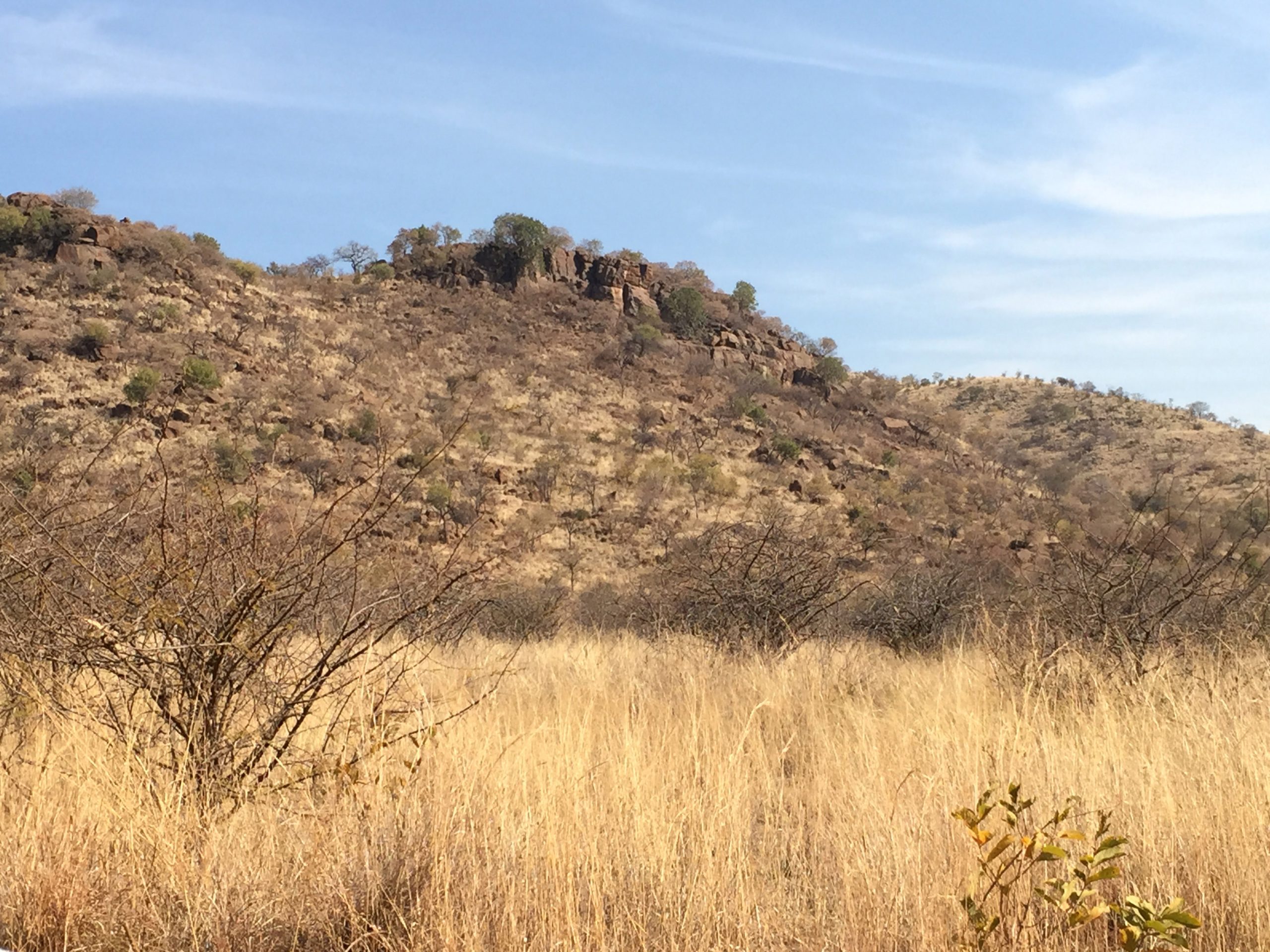
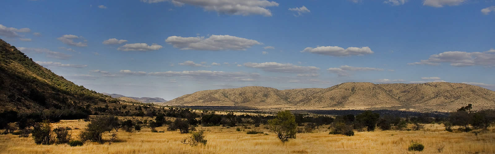
The hill rises up from the dry bushland plains, forming a 400 meter tall ridge with gaps. Pass through a gap and a new ridge appears, and another one behind it. In between are dry valleys. It is winter now and there has been no rain since early autumn: the rivers have dried up. After passing through several such ridges, the valley becomes wider and the hills are now further apart. There is a lake here, man-made, amidst the brown thorn bushes. The animals congregate to drink. Elephants abound, zebras herd and impalas jump. They are wary and with good reason: there are predators about, ranging from wild dogs to lions. The variety of animals in a smallish area already tells you that this is a wildlife reserve. Continue on your journey, and you will pass more ridges similar to the ones you saw before. Eventually the last range is reached and the plains suddenly open before you. The ridge behind you seems curved. You have traversed a circular, broken mountain.
The satellite reveals what is already evident from the ground. The ridges indeed form several circular, concentric ridges. Each ridge is perhaps a kilometer wide. The total extent is just under 25 kilometer, a distinct, isolated mountain on the plains. It is almost – but not quite – round. If you know whether to look, the peculiar Pilanesberg can be recognized even on coarse maps of southern Africa. It resembles the famous Eye of Africa, also best seen from space.

Sentinel image, October 2017. The map shows this remarkable feature of rings within rings. A fault runs through it from SW to NE, with a small offset along the fault. The bright area at the top is a platinum mine. https://www.esa.int/ESA_Multimedia/Videos/2017/07/Earth_from_Space_Pilanesberg
The Pilanesberg is the remnant of an old volcano. Each of the ridges seems to trace an apparent caldera, but one where the central hole is filled with another ridge and a smaller caldera. This nested volcano is like a Russian doll, each babushka containing a smaller one until there is no hole left. The structure is eroded, and the volcano is clearly deeply extinct. How old could it be? There has been no serious volcanism here since the break-up of Gondwana. But the Pilanesberg is much older than that. Its origin lies in deep time. The land itself is the elephant in the room: the African animals are living in a place that formed long before any animals existed, when Gondwana was a distant future and bacteria ruled the waves. This caldera is not just an ancient of days. It is an ancient of millennia. It formed a staggering 1.4 billion years ago. This is the oldest recognizable volcano in the world.

History
There is also human history here, near the border between South Africa, Zimbabwe and Botswana. The area was already frequented in the iron age, when it was a source of copper and iron. In the 1800’s a Tswana tribe lived here, the Bakgatla. They traced their origin to Chief Pilane, and the area is still named after him. The name Bakgatla refers to the local monkeys. In the Boer war the tribe sided with the English. That worked out relatively well for them: when in the 1920’s platinum was discovered, they remained the owners and received royalties from the mines. Part of the area was farmed, and the central lake was build for this. But farming was always marginal: even the ground water was barely useable, being saline and rich in fluorine. In the 1970’s it was decided to attempt a wildlife reserve in the area. There were fewer than 100 families living in the region: they moved out, and a reserve was created.
There is modernity here too, in a different kind of history. Sun City, on the southern edge of the Pilanesberg, must be one of the strangest holiday resorts in the world. It was developed in the (at that time) bantustan of Bophuthatswana. The bantustans were a series of semi-independent homelands for the black populations, created in apartheid-era South Africa, with as main aim to marginalise. The closest analogy is perhaps the native American reservations in the US. No other country ever recognized them, but this did not stop business from taking advantage. The Sun City holiday complex was build in the bantustan, away from the legal restrictions of South Africa. Gambling was illegal there, and Sun City therefore catered to a massive demand. It presented itself as ‘ the lost city’, a magical albeit imaginary place away from the real world. Here one could gamble, play golf on well-watered courses, swim in well-watered swimming pools, and enjoy world-class entertainment in the well-watered venues.
Nothing was real, of course. No lost city was ever like this. This luxury resort of the imagination, where people were invited to spend their wealth, was situated amidst the poverty of a dry and thirsty land. Sun City was created in the same year that the Pilanesberg became a game reserve and the animals were re-introduced. The Sun City holiday makers could take tours into an imagined Africa and see (but not shoot!) the ‘big five’, before their afternoon game of golf, an evening concert by Frank Sinatra, and an affordable flutter.

Ecology
The reserve now covers over 50,000 hectares, and is connected via a corridor to Madikwe, a similar-sized reserve on the Botswana border. The reserve remains small for a true African ecology. When it started, there had been little life here: farming on poor soil and roaming animals in search of food do not go well together. The animals had to be imported from other reserves. It did not go without a hitch. Some 15 years after the initial wilding, rhinos started to die. They would be found badly mauled. Which animal could do that? It was a mystery, a Death on the Nile where every suspect had an alibi and lacked a motive. The wounds fitted elephant tusks, but elephants do not kill rhinos. But the wounds did not lie, and the elephants had gone rogue. It turned out this was unsupervised teenage behaviour.
Elephants live in family groups, ruled by the matriarch. Female children remain with the group, but the male children leave the group once they reach 15 years or so and begin to live solitary. This began to happen at Pilanesberg. It turned out that these hormonal young solitary elephants had been turning violent, and they were attacking and killing the innocent (in a way) and rather expensive rhinos. But such behaviour had never been seen elsewhere. Investigations began.
The outcome was that a mistake had been made when acquiring the early elephant groups. The groups were taking from other reserves as complete units. But no solitary males had been included, as these were too big to easily move. It turns out that the mature solitary males keep the teenagers in check. Their dominance suppresses hormone production in the teenagers who cannot compete with them, and this stops the violence of the youngsters. In the absence of such elders, the teenagers had run riot. Eventually, a few older male elephants were transported from the Kruger to Pilanesberg. The rhino killing immediately stopped.
Rewilding sometimes does what it says. The elephants in this picture-perfect reserve replayed their very own Lord of the Flies.
Origins
There are geological riches here too. There is platinum in those rocks, and mines that dig for it still surround the Pilanesberg. At one time there was a fluorite mine. But the most important value is a link to the past. The Pilanesberg connects us to a deep past, and gives us a glimpse of how this land was created.
South Africa is an ancient land. Pilanesberg lies on the northern part of The Kaapvaal craton, well over 3 billion years old. 2.7 billion years ago it joined up with the Zimbabwe craton, in one of the earliest documented continental collisions. It formed a Himalayan sized mountain chain to the north of Pilanesberg. The two cratons have remained attached ever since: although the juncture re-activated 2.0 billion years ago, there was to be no separation. Together, they became known as the Kalahari craton.
The next event of note was a big intrusion, 2.061 billion years ago. It involved both basaltic and rhyolitic volcanism, but more importantly a huge intrusion of basalt formed below the surface, called the Bushveld complex. The magma chamber was a staggering 400 kilometer wide: the heat had melted the entire bottom of the crust. Was this a failed attempt at rifting? Was it a plume? The extraordinary magma chamber (the largest layered intrusion in the world) very slowly cooled and solidified: this took over a million years. It left behind a rich legacy: the world-class deposits of chromium, vanadium, platinum, and some rarer elements turned the area into some of the richest real estate in the world. Here is where the world gets its platinum, including from the mines which still surround Pilanesberg. A second intrusion followed 2.049 billion years ago with the Phalaborwa complex. It formed a volcanic pipe which has now been excavated to a depth of more than 700 meters. It is mined for copper and phosphate.

Bushveld complex (source: wikipedia)
More world-shattering events followed in this exciting 40 million years. 2.023 billion years ago a large asteroid hit the town of Vredefort – or at least where this town would be located in the distant future. It formed a crater 300 kilometers in diameter (the largest confirmed crater on Earth – some countries have all the luck), part of which still exists. The Pilanesberg area would have been destroyed by the magnitude-14 earthquake, and buried by the ejecta – the impact could have hurled blocks 4 kilometer in size 300 kilometers away. But the rocks underneath survived.
Now, activity calmed down and little noteworthy happened for 500 million years. Not entirely: there was a flood basalt 1.9 billion years ago but very little is known about it. The Congo craton came and joined Kaapvaal and Zimbabwe. A mountain range formed at the suture; it eroded, leaving a thick layer of sandstone sediment in the region. It is all just part of normal life for a craton. It seemed to become just another boring billion years.
Volcano!
But now, 1.4 billion years ago, there was something new. Rifting began in the area, roughly following the line of the Limpopo, the old collision between Zimbabwe and Kaapvaal. It came to nothing: eventually it ceased and the cratons survived. But it allowed magma to form, and this began to collect in the crust, looking for a way up and out. The magma was alkaline, rich in sodium and potassium. It formed a series of intrusions across the north of South Africa. The largest of these intrusions formed Pilanesberg, where on the surface a volcano began to grow. Some claim that the volcano reached 7 kilometers tall. That is based on the diameter of the Pilanesberg but the height seems strongly overstated. In any case, not enough has survived to decide on the original height. But what remains is impressive.
And there is more hiding underground. Surveys have shown the remains of a system of dikes, radiating out from Pilanesberg. The swarm of dikes extends to the south-southeast and to the northwest. It extends into southeastern Botswana as a 40-km wide band of anomalous magnetism. Pilanesberg is not exactly at the centre, but is about 20-km southwest of the centre of the band. To the southeast of Pilanesberg the band is less distinct but it broadens. One of the dikes runs under Pretoria, and a dike swarm south of Johannesberg may also be part of the same complex. The dike system extends 400 or even 500 km in total! (A dike swarm is called ‘giant’ if it is more than 300 km long.) The magnetic surveys have shown that the dikes often (but not always) have a magnetised outer layer but a non-magnetised core. This is explained as a dolerite dike which formed first, which was later intruded by syenite – the latter being non-magnetic.

Part of the Pilanesberg dike swarm complex
The dikes have opposite magnetisation to that of the Pilanesberg complex itself. The emplacement may have happened over a period which included a magnetic reversal of the Earth’s magnetic field. The dike swarm and the Pilanesberg are clearly closely related and are part of the same event, but the precise relation is not yet deciphered.
Other alkaline intrusions
The Pilanesberg intrusion indeed did not stand on its own. There are several intrusions of similar chemistry known in the wider region, with ages between 1.4 and 1.35 billion years.

Just east of Pilanes is the Crocodile River complex, a series of 4 or 5 volcanic remnants separated along a north-south line. The largest is Kruidfontein, a 3 kilometer wide caldera with two concentric rings.
The Pienaars River complex lies 150 km east of Pilanesberg and north of Pretoria. It consists of a series of intrusions over a length of 70 kilometers, extending northwest to southeast. Northernmost is Elandskraal, a true 10-km wide volcano with remnants of lava and pyroclastics. It is invisible at the surface but was found from geomagnetic anomalies. (It is close to the Tswaing impact crater. Some places have all the luck.) To the south, Roodeplaat volcano is rather similar to Pilanesberg but half the size and like Elandskraal not visible on the surface. There is a rim of lavas, an inner region of pyroclastics, and a series of plugs and dykes containing various forms of syenite. Just beyond is Leeuwfontein, also containing syenite dikes and plugs. It is the remnant of a trachytic volcano. There are several further locations with small volcanic remnants. Spitskop, 300 km east of Pilanesberg, consists of a 5-km wide ring, with a separate small intrusion 20 kilometer to the northeast. Another one is at Stukpan, 200 km south, just west of Vredefort. Others likely remain hidden below the surface. But Pilanesberg was the largest of these intrusions.
The combination of Pilanesberg, the enormous dike swarm and the other intrusions with almost but not quite the same age (1.4-1.35 billlion years) shows that something happened that was more than just the formation of a nice volcano. One possibility is that we are looking at the remains of a hot spot trail. The trail would start in Pilanesberg, the oldest, followed by the Pienaars River complex 200 km east and possibly 10 milion years younger, and finally Spitskop another 100 km in that direction and another 10-50 milion years younger (it has a much more uncertain age). Stukpan to the south does not fit in with the sequence and may be slightly younger. One could point at the Yellowstone hot spot for comparison, with its trail of large calderas starting from the major eruption at Steen mountain. Steen Mountain is also the origin of a massive dike swarm and the source of the Columbia flood basalt. However, there is no evidence of a flood basalt related to Pilanesberg. There is also no evidence for mafic material in the intrusion, however the original source may have been an alkali-rich basalt.
The second possibility is a failed attempt at continental break-up, as was mentioned already above. The alkaline magmatic intrusions of southern Africa appear to be found along old terrane boundaries and younger extensional faults. Sutures where continents merge (terrane boundaries) remain areas of weakness. The dike swarm and intrusion would come from a weakness in the crust as rifting set in. The Pilanesberg dike swarm follows roughly the direction of the Limpopo suture. The dikes followed the direction of the rift, just as they do in Iceland, and the width of the dike swarm show the total extent by which the continent rifted. The rifting model explains the extraordinary length of the dike swarm, and the offset of Pilanesberg which may have come from the rifting – the intrusion drifted away from its original location with the rifting (let’s call that adrift with the rift). But eventually the rift failed to develop further and the continent survived to live another billion years.
The bottom line is that we can’t always know! It is too long ago. However, the rifting model seems attractive. It has similarity to the Great Rift Valley in modern Africa, which has also reached 50 kilometers in width. No continent carries more scars from rifting than Africa. These are the wrinkles of age, where the magma in the dikes acts as the botox of the craton.
The rings of Pilanesberg
Ringdike outcrop. Source: https://earthobservatory.nasa.gov/images/86248/pilanesberg-ring-dike-complex
But how did the structure of the Pilanesberg form? It is clear that much of what we see formed underground, and that we are looking at the original plumbing, the skeleton of the volcano. The ridges were faults, filled with magma which hardened over time.
 The idea is that the underground intrusion had the shape of a cone. The picture shows the general idea. The ring fault has a cone shape, and the area around it subsided. This structure is inferred from gravity measurements. The cone-like fault developed from the pressure of a central magma chamber. As the chamber grows it pushes the land up and to the side. This allows cracks to form which radiate out from the magma chamber.

Source: Pilanesberg Guide, Jacana Education

Source: Pilanesberg Guide, Jacana Education
Here is a cross section from Sun City to the lake (not quite at the centre), and out along a different direction. Every ridge is named by its main composition. The outer ridge, on both sides, consists of red syenite. Other ridges are white foyaite, green foyaite and Ledig foyaite. In between are volcanic rocks: pyroclastic tuff and lava. At the centre of the volcano, there are parallel bands of red syenite and red foyaite. The alkaline rocks are rich in fluorine, light rare earths, strontium, thorium, and uranium.
Some of the tuff is radioactive (only mildly!), with an unusually high uranium and thorium content. This came towards the end of the life of the volcano, when heated water penetrate the tuff layers, carrying the radioactive oxides. The Ledig foyaite also has some uranium aded to it, though not in mineable quantities. The red in the red syenite comes from ironoxide, also carried in by water.
From a previous post on igneous rocks you may remember that dolerite (found in the dike swarms) is a medium-grained basalt, commonly found in dikes . Dikes cool faster than magma chambers, and therefore the grins have less time to grow. Magma chambers form gabbro (coarse grained) as they cool. This was the original intrusion.
Later, the intrusion became more alkaline, with potassium replacing the calcium. This formed an alkali feldspar: syenite, a kind of granite with more potassium. (I am waiting now for a true chemist to jump in and correct me!). If it erupts on the surface, it become trachyte – found in the remnants of the surface eruption in this region. Foyaite is also a syenite, but it contains less silica (and no quartz) and instead contains other, rarer elements and minerals. It is found mainly in connection with continental rifting.

Survival
It is amazing that a volcano almost 1.5 billion years old has survived until the current day. In fact, it is incredibly well preserved, with parts appearing just as they had formed. Erosion has been kind to it. But why? It probably formed only a little above sea level: erosion is slower at low altitude. The area may often have been dry, being at the centre of a continent. But that seems insufficient to explain the oldest volcano in the world.
Pilanesberg formed in a failed attempt to break up southern Africa. But now came the era of the supercontinents: 200 million years later, Rodinia began to assemble. During this event, a flood basalt covered part of the region in lava: it is called the Umkondo Large Igneous Province and it covered 20 million square kilometers with lava. The remnants are found even in Antarctica. For a while, the layers of lava may have protected the original surface against the slow ravage of time. A continental collision occurred to the south of the Kaapvaal craton. This formed mountain belts (part of the Kibaran belts) with extensive folding in the Northern Cape but it did not affect Pilanesberg. Rodinia broke up again, but only partially and the Kaapval craton remained in the interior of a fair-sized segment. Later, Gondwana assembled with activity all around the edges of Kaapvaal. The famous granites around Cape Town (Pearl Rock, Boulders Beach, but not the even more famous Table Mountain) formed at this time. New mountains ranges formed, and these quickly started to erode again, leaving their sediments across the land. The ancient Kaapvaal craton found itself surrounded by all this activity. But Pilanesberg never took part: enclosed by mountain ranges, as if in a fortified estate, it remained unaffected. 500 million year ago a rift developed along the southern Cape, and the sea came in. Deep sandstone sediments formed, including what later would become the most scenic mountain in the world (in my humble opinion), Table Mountain. Drive along Chapman’s Peak (take your time: you’ll be stopping at every bend, and there are a lot), and you will follow the contact between the granite below and the sandstone above. But the sea did not reach Pilanesberg, which still quietly slept while the world around changed and changed again.
Now, finally, it did begin to take part in events. A mountain ranged formed north of South Africa, covered by a thick ice sheet: the continent at this time was situated near the south pole. The ice descended to a shallow sea which covered the Karoo. This must have affected Pilanesberg which lay in between. The area may have been the recipient of sediment brought by the descending glaciers, but no such sediment is known in the area (there is some a bit further south). It has been suggested that this deep glacier instead eroded the rocks and created the current structure, with the hard ridges sticking out above the softer volcanic rocks and the surrounding area. Now the continent drifted away from the pole, towards much warmer regions. The ice disappeared and a delta formed along the northern mountain range. Sediment now covered the region again. Later the climate dried and the region became a deep desert, a sea of sand. And 180 million years ago the unthinkable happened: South Africa broke up, along a line not too far from Pilanesberg. An immense flood basalt formed, and the sea of sand became a sea of lava which covered much of South Africa. The highlands of Lesotho still show this deep pile of lava. After the sand, now kilometer-deep lava also covered Pilanesberg. This became its final saving grace. Over the 180 million year since, erosion took away both the lava and the sand that covered Pilanesberg. Some 30 million years ago, the erosion had removed the new (compared to the age of Pilanes) surface down to the level of the top of the ridges. This was also the time the African bulge formed, and the land began to rise. Did this increase the rate of erosion? The sediment that had filled in the valleys and covered the surrounding land was removed by rivers. And so the Pilanesberg re-appeared, looking like it did after the age of ice 300 million years ago. It has left us just enough. After the many years of quiet, and the years of being buried, the ridges appeared on the surface. And so, after almost one and a half billion years, while even the Moon had grown old, the Pilanesberg we know took shape.
One more thing had happened in the mean time. Around 90 million years ago a different type of eruption occurred within the Pilanesberg. It happened in different places across South Africa: Kimberlite. These are eruptions from the deepest of the deep, 200 kilometers below. Sometimes, but far from always, they bring up diamonds. One of these kimberlite eruption occurred at Pilanesberg, in between the eastern ridges, and it added a new type of volcanics as a small pockmark to this ancient of days.
Erosion is still occurring: it cannot be stopped. Weathering breaks down even the hard syenite of the ridges, and rain and gravity takes them to the valleys. A soil formed, and this soil attracted the farmers. But such an old land has little fertility left, and some of the local chemistry was positively unhealthy. The farmers reached the limit of what was possible and decided that enough was enough. The land was returned to a semblance of wilderness, so that we could see what Africa, our old home, could still be like.
Against all the temptations of Sun City, still people come to see Pilanesberg. Instead of a lost city, they find a lost world where hyenas laugh, monkeys play and bushbuck hide. And all around them is an ancient heritage. They live within an excavated volcano that formed when our world was young.
Albert, February 2022
Further reading


Good article there, Albert. I pretty much have never heard of Pilanesberg before since I joined the VC Club, so this was a bit of an eye opener for me. This also made me sort of wonder about the uranium within the tuff. I know that the uranium there is hydrothermal-formed and concentrated, but I remembered that Nyiragongo’s lavas have a slightly elevated levels of uranium in it (not to the point where it’ll affect you or the US military in 1960’s decides to get it, but still a bit surprising for scientists), and since Nyiragongo sits on a sort of high melting area, it might be possible that a deep plume might’ve brought that up from the core. (I don’t know, but that is what I assumed).
In spite of being so heavy, uranium is not expected to be in the core, at least not in large amounts. Instead it is expected to reside mainly in the crust and and at lower concentration in the mantle, as an oxide. Uranium does not bind to iron or sulfur, and that is what is found in the core. It is one of the reasons why the Earth’s core is solidifying quite rapidly: lack of heat from radioactive decay.
Soo just primodial heat .. and No radioactive decay in Earths core? It was competely liquid in the hadean As the magma ocean and liquid iron sepparated
Then the most radioactive heating is in the rocky mantle I guess sourrounding a core thats inert. But the crystalization of the core also produce some heat
The heat in the core comes from three things. The first is left-over heat from its formation. The second is the heat released by the solidification of the inner core. The third is the contraction as the core solidifies. Energy loss is mainly through mantle convection.
Nyiragongos unusual lavas are produced by very little partial melting deep down
Large ammounts of partial melting generates normal Icelandic/Hawaii basalt
Thought to have once held over 1,000,000 km3 of magma, the Bushveld Complex is the largest magma chamber preserved on the surface of our planet. Very fascinating intrusion.
One has to wonder if Bushveld ever caldera collapsed.
None of the rivers in the region have shown sediments containing Bushveld minerals. It it ever collapsed, all ejecta were fully removed by later erosion across the entire drainage system. There was volcanism (hard to believe otherwise!) but a large scale collapse could have left something somewhere. Ejecta from Vredefort (which is about the same age) have been found.
Fascinating thoughts by you about the Hunga-Tonga larger area on Carl’s post.
Many thanks for this article Albert. I had a very frustrating visit to Pilanesberg some years ago, in company with some colleagues who had no interest in the volcanic formations. Yes – the wildlife was fascinating – but volcanos!!! It’s really good to finally see so much of what I missed, while actually there.
Thank you, Robin. Glad to be able to add to your visit. And yes, the volcano is the elephant in the room – easy to miss!
Bravo !!
Another wondrous article, and a fascinating tour of ‘Deep Time’.
Hmm: I’d thought kimberlite ‘pipes’ old, But, by comparison with such ‘primordial’ cratons, they’re almost recent…
( WTF triggers them ?? )
Interesting piece about one of the oldest (visible) parts of Earth.
Elefants with high testosterone seem to have replaced rhinos with silver VW’s:
https://www.pilanesbergnationalpark.org/media/elephant-gets-friendly-vw-pilanesberg/
This question might be stupid, and I apologize if it is. I was just wondering with the age, the size and these rings and then those dikes reaching out whether the structure could be compared at all to Coronae on Venus.
It is actually an interesting question.
It could be compared, although the structures are a bit different. Pilanesberg is a pluton with ring dikes, a silicic magma chamber. Coronae are giant cone sheet/circumferential dike swarms, and most likely contain layered intrusions in their center. Bushveld may have been similar to a large venusian corona when it was active.
On Earth cone sheet intrusions are generally small. For example the volcanoes of Galapagos do cone sheet intrusions that erupt from circumferential fissures surrounding the caldera, these intrusions then rotate into radial directions and erupt from radial fissures in their flanks. Hunga Tonga also had a bunch of cone sheet fed fissures along its southern side, including the eruptions of 1988 and 2009.
Venus has giant cone sheet intrusions. Venus also has giant dikes and giant eruptions, it is a different scale of volcanism. On Earth such giant intrusions occur only in rare large igneous provinces. The Kunene Kibaran LIP is a great example of such a giant cone sheet swarm, also called circumferential dikes, which not the same as ring dikes:
If there wasn’t any erosion then it would preserve the ground when the giant cone sheets intruded. Each cone sheet intrusion would correspond to a fracture system on the surface. Thus it would create the pattern of concentric fractures seen in Venusian coronae and also in Martian giant cone sheet swarms. In the Kunene Kibaran LIP you can see the center of the giant circumferential swarm is occupied by layered intrusions and granites, these correspond to a huge magma chamber similar to Bushveld. Same as cone sheets surround magma chambers of Galapagos volcanoes, giant cone sheets surround the massive magma chambers at the center of LIPs, like Bushveld, Muskox or other large layered intrusions.
See a comparison of structures. The Kunene Kibaran LIP, the ancient centre 3 Mull volcano (a normal sized volcano compared to the giants above and below), and a simple Venusian corona in Magellan radar. Other coronae are more complex shaped when they interact with compressive stresses or when they develop the fully mature structure of a central plateau surrounded by a through.
Great, very detailed answer with examples. Quite nice of yours, thank you.
Let’s see if Mull shows up now.
Kunene Kibaran is something like 50 times larger in width than your average volcano (Mull), which might be 500 times the area covered, and 5000 times the volume stored, perhaps. Otherwise the structure is the same.
Somewhat related to this, but is it possible that Olympus Mons had some sort of structure similar to that to Venus’s coronea? I mean it doesn’t look that elongated, which would be typical for a volcano with a few long rift zones.
I also thought, at the same time, Olympus Mons is just a bigger version of the volcanoes in the Galapagoes. Or is it something else entirely?
Olympus Mons is made of overflows originating from the summit, that is not too Galapagos like. But it does have a giant cone sheet swarm, it is very feeble though. Here the fractures are shown in blue, most of them corresponding to the cone sheets:
Other Martian volcanoes have more well defined coronae. Like Elysium Mons, red shows the fracture systems of the giant dikes and cone sheets:
Syria Planum also has a significant corona, although somewhat asymmetric and ugly looking.
Here’s also an interesting passage from some older piece of Albert’s:
“Ring-dike intrusions have some similarity to coronae and it has been suggested that coronae are oversized ring dikes. But ring dikes do not show the outer depressions that many coronae show.
Drifting plates and the battle against mantle plumes
This leaves one question unanswered: why coronae are so common on Venus (513 are known) whilst absent on Earth? Mantle plumes happen on both planets, after all, and Earth has some thick crust in the old cratons. Kimberlite plugs form when mantle melt punches directly through the crust, and these are not uncommon on Earth. Are Kimberlite plugs micro-coronae? Or a mini-nova?
An interesting suggestion is that on Earth, continental drift stops coronae from forming. The idea is that a corona needs a long time to form, perhaps 100 million years. In that time, Earth’s continents move and the same point does not stay above the plume. Only Africa is currently near stationary, and that has only been since the last 30 million years. Instead, on Earth a mantle plume develops into a hot spot trail. Put the plume underneath the same bit of continental crust for 100 million years, and perhaps you would get a corona. If only these continents could stay put long enough.”
https://www.volcanocafe.org/terra-nova-the-eye-of-africa/
My suggestion is that Venus which needs much more research had water, but not as much water as Earth. I wonder about the possibility of a relationship of 30:70 ocean to craton on Venus instead of the other way around, plus the thicker crust, plus the slow rotation leading to a massive volcanic eruption with the evaporation of all water. But these things are speculative, but still interesting. Whenever I read some about Africa, also Chad and Libyan volcanoes, Venus comes to mind.
An rlevant consideration is that coronae are mainly systems of surface fractures, except the biggest complex ones. If there is erosion then the corona disappears.
If Venus had erosion then there wouldn’t be any or almost any coronae given that they formed 450 million years ago.
One problem in studying Venus is that the whole planet was resurfaced 450 nillion years ago. So the majority of Venus’ history is lost, buried under probably kilometric piles of lava and intrusions.
Yes, that makes it so mysterious. One day there will be the right material and technique to collect rock there. It is indicated in a film I linked to under Carl’s last post, closer to the end of comments.
I got to the corona idea 1) visually, 2) as Albert mentions in this piece that erosion has been “kind” to the structure.
Technique (I consider fascinating) starting at about min. 30:
Thanks Denaliwatch that is a fascinating, beautiful documentary.
Hector I think you might be interested in this 🙂

The structure is now buried but last week there was a sort of ring faukt structure visible around the lava lake basin at Kilauea.
One can though see a bit of it still showing through on the left side of the lake today.
I think in a way this lake is not best modelled as a simple rootless lake but as an actual magma chamber just with a thin roof. The majority of the rise of the lava surface in the past week has been from overflows, rather than the crust lifting, closer to shield building. The active pond actually is making a small shield, it is raised over 10 meters higher than the lake basin.
It also seems that the idea of a permanent open conduit existing into the lava lake is now more widely accepted, it is not just a dike held open by pressure like the eruption a year ago was, this is here to stay 🙂
Thanks Chad. The idea of considering it to be like a magma chamber I think it’s appropriate. For example the lava lake of Makaopuhi has been drilled, I can’t recall if it was the historic lava lake formed in 1965, I think, or the prehistoric lava lake. In any case the solidified remnants had formed layers of different crystals as the lake solidified and the composition changed. This was following the order of crystallization, first chromite, then olivine, and not sure what came next. It got pretty felsic in the end if I remember correctly. This is a bit reminiscent of mafic magma chambers, of the layered intrusions.
So it acts like a magma chamber covered only by a thin crust. A rootless lava lake can also feed intrusions and eruptions. This was revealed by the dike intrusion and eruption of Alae rootless lava lake in 1969. And also, in all likelihood, some of the 19th century dikes where fed directly from the lava lake filling the summit caldera.
I guess Kilauea is probably one of the closest things to an active LIP that we have got today. Technically by volume Hawaii actually is an LIP, it is much more voluminous and formed in a shorter time than the Columbia River basalts, for example. But Hawaii still doesnt quite have the lateral extent of a flood basalt volcano, it is sort of an intermediate. Iceland might be slightly closer in that regard, though still a fair bit smaller.
Kilauea looks like it is transitioning into a new shield eruption. Probably all activity will be at the summit for a long time now, maybe even decades, though it is only a strong quake away from a sudden swap. Will be interesting to see the caldera fill up. it is also quite possible as the fillign gets more complete other magma chambers in the summit area, those under Keanakako’i and Kilauea Iki, those will also begin to form open conduits and shields/lava geysers. In any case I highly doubt the caldera will last more than 20 years unless the ERZ opens again.
Yes, Kilauea has a high supply. It is not just that it has a high supply though but that it keeps it up for a long time. In reality many volcanoes can have magma supplies that at times match or exceed that of Kilauea, like Santa Maria (Guatemala) during the past century, possibly Fagradalsfjall right now, or Krafla when it was doing its Krafla Fires. But usually such high supply only lasts years or decades and then the volcano has little activity for thousands of years. In Hawaii however it seems the current magma supply is long-term, and that it is always flowing out from either Kilauea or Mauna Loa, although my personal opinion is that Kilauea is satellitic to Mauna Loa, and thus would be the Mauna Loa system which is always running.
I’m not sure I would compare them to a LIP though. A LIP would be able to erupt the whole volume of Kilauea in a few, or even in one eruption. A LIP would also easily send dikes from Hawaii to Kauai and make a graben system that cracks up the ground in between. I think of this as how great is the eruptive and intrusive capacity. In this sense the eruptive/intrusive capacity of Kilauea is not any greater than other mafic caldera systems of the planet. I don’t think there is that much of a difference between say Askja, Kilauea, Masaya and Sierra Negra. They have different eruptive styles, their eruptive capacity shifts over time, but stays within a similar range for all four volcanoes. The eruptive capacity of LIPs I think might be something like a thousand times superior to the aforementioned caldera systems. Although this is something that I need to give more thought to.
As far as we know, a LIP forms within 1 to 5 million years. It is one major intrusion, fast enough that hot spot drift is not important. We do not have anything similar on Earth at the moment
That is what sets Hawaii apart from almost any other location, its supply is high at a base rate and focussed to one spot, where other places are quite comparable at times but very intermitently. Even Iceland and Galapagos are sharing their plumes among many co-active volcanoes, Hawaii is only 2 at most or even just one with two rift zones by your theory. If Mauna Loa and Kilauea are one volcano it is most certainly the single most productive source of magma on this planet. As for Hawaii being not a corona structure, it probably has something to do with its location, in ocean crust. All those giant systems are continental, and other planets have thick crust too. All of those other volcanoes also caused rifting within the crust itself, where Hawaii this process is a bit more superficial. It is sort of more like if Iceland was only one volcano. Yellowstone plume was able to make such a structure in the Miocene, and Reunion in the late Cretaceous, both less powerful than Hawaii plume today. Perhaps Galapagos would be comparable, Sierra Negra actually is a ‘tiny’ corona structure, we got lucky they are both out in the ocean I think.
Virunga might have serious potential, I have to mention it is nearly exactly at the center of that Kunebe Kibaran complex. It is a second go at rifting that spot, and if the last round was able to create such a monster…
The stresses influence how intrusions occur in Hawaii. There are extensional stresses induced by the flank slip. This causes dikes to grow linearly and not radially or circumferentially. This varies however.
The Upper East Rift Zone of Kilauea is where extension is the greatest. The maximum flank slip in is front of it. In this area dikes are almost vertical and sills are absent. The extension causes the dikes to be almost fully vertical.
The summit area, and the Middle and Lower East Rift Zones feature frequent sill intrusions and the dikes are more noticeably tilted, I don’t remember how much, but the difference with UERZ is significant. Because the ground slopes southeastward the dikes are more influenced by topography and they also dip southeastward.
Mauna Loa normally erupts from linear dikes that dip northwestward. This is caused by slip in the Kona and Kaoiki-Hilea seismic areas which induce spreading of its southwest rift. However the northern flanks of Mauna Loa feature radial intrusions, this is because the extension doesn’t reach here. It is the area that is buttressed between the intrusive bodies of Kilauea, Kohala and Hualalai. Mauna Kea is also trapped in the area in between the intrusive complexes so it has a fully radial disposition of dikes.
Places like Reunion or Galapagos lack volcanic spreading so instead they develop the more typical style of intrusions. Intrusions generally start as sills which grow radially from the volcano. These sills may rotate into dikes. The dikes follow circumferential directions making a sort of corona surrounding the center of the volcano, often encircling the caldera. Outside this ring the dikes acquire radial or linear directions. The center of the ring is often dike free. Usually there is some direction that is preferred, making diffuse rift zones but where dikes are spread out over a wide swath. Sometimes they have three, four, five or more preferred areas for dikes to follow giving the volcanoes slightly star or polygonal like horizontal sections.
The volcanoes of Mars and Venus make intrusions in a way akin to Galapagos or Reunion, and different to most Hawaiian volcanoes.
I would say that the only possible exception is Theia Mons. It is a little more odd than most of the volcanoes on Venus, which it seems to have 3 “rift zones” that extend from its summit. Is there some other mechanism causing this? Or is it another but odd nova?
Venusian volcanoes intrude the Galapagos way, even though there are many rift zones and extensional structures. It is however to be considered that intrusions can locally induce extension in the intruded area while compression around it. For example, large coronae become circular rifts, with a central rift valley and uplifted flanks. Like the East African Rift but turned into a doughnut. Such circular rifts cannot have been created solely by tectonic processes but must have been linked to the giant cone sheet/circumferential dike intrusions.
Elsewhere in the planet the stresses are compressional as seen by thrust faults, called wrinkle ridges, which are distributed almost everywhere across the lava plains that make up the planet’s surface. It is very different from Earth. Venus doesn’t have plate tectonics so compression and faulting occurs evenly throughout the entire planet. In Venus compressional stress, I suspect, was created by the giant dike intrusions formed in the 450 Ma flood basalt events, which occur in mind-boggling numbers.
This is also similar to Mars, where about 3.5 billion years ago there was a volcanic episode, maybe the greatest the planet has experienced which built many shields over the planet, the one centered in Syria Planum for example. Also during this time the lava plains in Tharsis, Hesperia Planum, and other places underwent intense thrust faulting, even making veritable mountain ranges at places. Later volcanic episodes have not resulted in such spectacular faulting.
As for Theia Mons and nearby volcanoes, they are oddities indeed. The area is domed up by kilometers into several mountains. These mountains are volcanoes and they also radiate rift zones, like Theia. Some of them have erupted very little lava, and a few haven’t erupted any lava at all. They are like unhatched eggs. Deep magmatic processes were/are occurring but have not culminated into the volcanism that is seen elsewhere in Venus. Either it’s a presently emerging volcanic province, or it formed towards the end of the 450 million years ago flood basalts and magma supply ran out as they where developing.
Also about lightning at Hunga Tomga Hunga ha’apai…
https://www.theverge.com/2022/2/17/22939328/tonga-volcano-plume-record-height-nasa
Most powerful thunderstorm ever recorded.
Copy:
I suggest you maybe add a map of Earth around 2 Ga. It is a bit difficult to imagine what happened. I only found a globe. With this globe I couldn’t tell whether the volcanism was subareal or submarine.
https://www.smithsonianmag.com/science-nature/travel-through-deep-time-interactive-earth-180952886/
Basically, if it goes too much into Deep Time, even somebody who is extremely interested in the history of Earth, the Solar System and Plate Tectonics, has difficulties following. This also concerned “White Christmas” and Rodinia. That’s why the commentators might not be here. It is harder than you yourself with the brillant imagination of an astrophysicist can imagine. Imho.
My limit is s.th. like 500 Ma.
Sorry for the slight criticism which only concerns the topic, not the writing.
This map might help a little (there seems to have been little continental crust first, and therefore the volcanism might have started in the ocean, then appeared subareal and added to the cratons):
https://sp.lyellcollection.org/content/357/1/1
Australia is very similar to the Kaapvaal and may have been attached. To the south, Antarctica has been suggested. But things have moved around so much. It is like assembling a big puzzle where the picture keeps changing, pieces are missing, new ones are added and pieces change shape!
You might mean this, impressive:
https://sp.lyellcollection.org/content/357/1/9/tab-figures-datawidth=800&height=600&carousel=1
It does show the range of possibilities! And the rest of the reconstruction is equally adjustable. I think that when Antarctica emerges from the ice, that we will find a lot of clues there. Assuming that decompression melt does not obliterate it under new lava
With regard to the comment above about Virunga, Chad, it does seem as though dike swarms pop up in the same areas of crust over time. For example Mistassini and Matachewan, those mentioned in the post in the south of the African continent, and also there has been something like 16 LIPs around the outskirts of the Siberian craton, before, including, and after the Siberian traps.
This site is great:
http://www.largeigneousprovinces.org/
Yes, that is one I use
I have the idea that the oldest volcanism here started in a marine environment (s.th. like Hunga Tonga), then appeared subareal and connected the two cratons, whereas the second, 1.4 Ga appeared to separate the cratons – like mentioned by Albert – and failed. There must be more of this on Earth, but miraculously, this area is not completely eroded or overgrown.
Weak spots will be preferred, I guess. In this case it is though a weak spot that has not been rifted in over a billion years successfully if ever, perhaps this will not be either and Tanzania craton will stay attached but this has already given a better go than most. And Virunga is still young, with really serious basaltic volcanism only beginning within the last 50,000 years. At present volcanism is alkaline, so magma generation is low percentage and deep, but there is so much of it (possibly 1 km3 per decade) that there must be a massive area undergoing melting. Not to mention Both volcanoes have lava lakes and go head to head with Hawaii for the biggest title, that requires colossal heat flow.
In maybe the not so distant future the crust might well have rifted enough to properly decompress the mantle and give tholeiitic basalt in enormous volumes, probably more than Hawaii and Iceland combined, then we get a basaltic supervolcano, a second Kunene Kibara. Probably takes several million years to form a mature corona but the first really big eruptions and intrusions could be within the next million years, we probably are watching the birth of a new Deccan Traps here.
Reuinion was alot more powerful 66 million years ago, its arriving superplume head was that created the Deccan Traps .. that arriving plume head have long since ”burned off”
The Reunion today is the dying stalk thats left behind thats still going strong
Hawaii have had a similar development, althrough its much much much stronger as a plume..compared to Reunion. It formed 80 million years ago it too surfaced in a catastrophic LIP as the newly arriving plume head began catastrophic decompression melting forming an event similar to ontong Java plateu, perhaps even bigger
The 80 ma Hawaiian Flood Basalt Province have long since been subducted under Asia, and is visible in some mantle tomography maps
Galapagos Plume too surfaced in a big scale LIP
What makes the Hawaii Plume unique on the planet today, is its strenght, and productivty, Hawaii is probaly the hottest mantle plume on Earth in a very long time, its been a blowtorch for tens of millions of years through the Pacific Plate
Hawaii is a monster plume and its Not loosing strenght at all, since the last 2 million years Magmatic productivity have gone up in Hawaii, producing the gigantic Maui Nui and most of Big Island in much less than 1 million years
Hawaii Plume is probaly feeding directly from the Earths Outer core getting its heat there, a hot rock pillar column channel that goes directly to the core of the planet
Since Hawaii is so very strong as a mantle plume, and its refusing to cool off, it Will probaly be active for a few 100 s of millions of years into the future
That is why I think Hawaii would be a LIP flood basalt if it was under a continent, it is the location on an ocean plate that prevents it from forming a massive magma chamber in the crust that can generate such flows. Instead it forms a ‘normal’ volcano but one of really massive scale. If one considers that a LIP usually is a few million years lifespan, then basically all of the modern Hawaiian islands should be included by volume as a fair comparison. Adding of all of the main Hawaiian volcanoes gives a volume of around 750,000 km3 of lava in 5 million years. Now imagine it was erupting in the middle of Africa, all of that magma would go to one location and would not form a trail but build up, and you get a magma chamber of such scale – there is your corona structure.
So basically Hawaii is a LIP that was in the wrong place. I think big oceanic LIPs must form in a slightly different way to those on continents, maybe those really are plumes that first break the surface so there is a Hawaii-like magma source but it is wide, so you get a really huge area of melting, and a magma chamber forms under the crust instead of in it. Continental LIPs probably dont have to be new plumes, or even plumes at all sometimes, a normal hotspot that is overriden can have its magma trapped in the crust which will generate such a volcano, no need for new plumes. That being said a new plume rising under a continent probably would be quite the disruptive event too…
Indeed the Hawaiian volcanoes are astonishing!
Big Island itself haves many many many times the volume of Columbia River Basalts
Igwisi Hills in the south centre of the Victoria plate suggest a deep large pulse aiding the rifting/rotation. These are kimberlite volcanoes that have punched through granitic gneiss. Quite recent too.
Virunga is an Intresting future: infact that whole part of Africa is uplifted and rising .. looks indeed its there we will get the next LIP its an arriving mantle plume thats just started to melt
In a few 1000 years Nyiramuragira will grow into a giant If it keeps up the current magma production perhaps in the future it will become a future ”Land Mauna Loa?” with its production, Nyiramuragira is probaly only going to produce more and more lava in the future, althrough Mauna Loa is its own small LIP with 100 000 km3! ML Dwarfs everything in other active volcanic edifices
Nyiramuragira is at current 500 to 600 km3 and is a very Young volcano
As time goes by.. lavas in Virunga will get less and less alkaline as melt production increases, perhaps Thoelitic Basalt will jump out of Nyiragongo quite soon
In the far future the Virunga Litosphere Boulge will pop and radial fissures many
100 s of kilometers long will spew thoelitic lava fountains 100 s of meters into the air!
The future dreams of elephants and lions running from a fast moving country sized 50 meters high Aa lava wall will become real 🙂
When the Virunga mantle plume boulge starts its decompression melting it will perhaps be on LIP scale as Chad says.
But probably not on the Pangea breakup in scale
Nyiramuragira, Nyiragongos sister volcano is probaly the worlds 2th most productive volcano after Kilauea at the moment. The future looks very bright for Nyiramuragira
Probably will take millions of years of evolution to become a mature flood basalt volcano, likely all the provinces were active on lesser scale before going big, but then we dont really know because they are all either completely eroded or still largely intact.
I have wondered if maybe the Undara province in Queensland Australia is a possible analogue. It is two active volcanoes, McBride which is a shallow shield, and Nulla which seems to be possibly fissure swarms but with no surface expressions. Nulla is possibly dying slowly, it erupts maybe only every 100,000 years or more, but McBride is very much alive and erupted only 7000 years ago and at intervals an order of magnitude more often than Nulla. Both are around 7 million years old but the majority of McBride is less than 1.5 million years old.
McBride is the location of the famous Undara crater, source of some of the longest preserved lava flows we can see today.
The province is still alkaline too, but nearby Atherton had tholeiitic shields at its peak, the Newer Volcanics down in Victoria also had a tholeiitic stage, so seems likely McBride will do so in the future too.
It sounds like a good topic for a post.. hint..
Actually, I have been trying to write a post on Undara for over 2 years now… There just isnt much information on it. Doesnt help that it was regarded as extinct until 2020 and still listed as such on GVP.
So it’s the tholeiitics. My garden is a nano fraction of Victoria’s Newer Volcanics, but you should see my roses and delphiniums. And weeds rampant.
Chad, here is one piece about Pilbara which is depicted (link from me a little up) next to Kaapvaal. Maybe useful as a starter:
https://theconversation.com/how-the-pilbara-was-formed-more-than-3-billion-years-ago-94977
Also interesting, Chad:
“Earth itself is a bit more than 4.5 billion years old, and the researchers hope the new finding offers insights into the formation of the moon and the first continents. The Jack Hills rocks formed only about 160 million years after the formation of the solar system—which is surprisingly early.
The zircon crystals analysed by the researchers in the Nature Geoscience journal study point to Earth’s earliest crust cooling from a planet-wide lava ocean. The lava ocean was likely born in the astronomical collision that created the moon.”
https://www.nationalgeographic.com/science/article/140224-oldest-crust-australia-zircon-science
Ahum. The dates are for the zircon crystals. The rocks themselves are not as old. The crystals would have formed from magma, but zircon is very resilient and they can survive a lot, perhaps apart from deep subduction. The oldest actual surviving rocks are probably a bit less than 4 billion year: they have been found in Greenland and Canada.
Albert,
okay, taken in. At least – I want to mention it – I became a bit interested in the oldish stuff. As usual on VC. First reaction: Oh no, not that time. Then some reading and some follow-up interest. There is s.th. though much older which is fascinating. And that is the question of water. Was Earth possibly the lucky one that got enough water very early and developped a protective atmosphere as early? Was the Magma Ocean possibly absent on Earth? All these different theories about water and life are interesting as well.
Our water remains a bit of a mystery. It seems an addition from after the Earth formed but (I think) before the Moon formed.
“Dikes cool faster than magma chambers, and therefore the grins have less time to grow.”
Interesting turn of phrase there!
Maybe I should fix that one..
I thought the mental image of incomplete grins on magma dikes was superb. It made me grin too. 🙂
Thank you for this superb article. I’d never heard of this volcano before.
West-Mata, not too far from Tonga, video of submarine eruption:
https://ocean.si.edu/ecosystems/deep-sea/submarine-volcanoes-erupting
Thats also a very unusual lava Boninite.. a kind of ultramafic andesite that emerged at over 1300 C making it the hottest lava ever seen erupting, it maybe 60% sillica .. But as fluid as fagradalshraun because of its high temperatures that breaks down the sillicate polymerisation, 2009 was the first time in world history that a Boninite lava eruption was seen in action
But Hawaii and Iceland are much hotter deeper down
Yes, Jesper. And it seems to be more frequent here in the West-Pacific than elsewhere in the world.
https://agupubs.onlinelibrary.wiley.com/doi/10.1029/2009JB006367
Kilauea really putting on a show right now, the lake is full but most of the action is at the cone, which is fountaining and erupting a lava flow of its own.
OT: Etna in big action (Youtube LocamTeam, Skyline webcam)
Thanks! Nice paroxysm ongoing.
Héctor, just saying: After I saw what you posted under Carl’s pottery post I think you could write a very fine piece about the Tonga- and Kermadec Arc Area. Please think about it. And look for my links to some precious articles that might be helpful. The area is more than interesting.
I do have considered writing an article on Tonga. However right now I’m focused on developing an idea of mine on intrusions and volcanism, putting together data.
Thank you Albert. That’s a fascinating article on a place that was formerly a complete void on my mind’s map of planet Earth.
Thank you! It came from an emailed question about the area by one of our readers which made me curious.
Lava keeps flowing into the Halema’uma’u crater … like an unstoppable tap of liquid rock
It is goign quite insane right now, that lava channel is completely glowing along its entire length, flowing fast enoug hto cover its length without cooling. based on domensions given the channel is probably about 12 meters elevation gradient and at least 30 meters long, maybe a lot more. Lava also takes about 2 seconds to crust, so it is flowing at around 15 m/s or over 50 km/hr. All very estimated numbers but still it is clear that lava is moving really fast. Then there is the big flows above the lake, it almost made a second perched lake but then the wall broke and it all poured in.
I think this surface activity is entirely the gas rich lava foam that rises directly from the open vent and is able to surface before it sinks back down. There is no lava overflows of the lake basin so it is obviously draining into the underlying lava through holes somewhere.
I also get the feeling the cone is trying to self destruct, and become a big open lava pond of its own.
I get the feeling that the form of the whole island is very similar to the form of Oahu Island. There was a caldera there as well. Today it is called Kāneʻohe Bay. The mountain range behind (Koʻolau Range) is pitturesque.
I think this doesn’t sound too nice:
https://en.wikipedia.org/wiki/Halema%CA%BBuma%CA%BBu#April_to_July_2018:_Drainage_of_lava_lake_and_the_collapse_of_the_summit_caldera
I wouldn’t be surprized if the whole flank collapsed like on Oahu in the past:
“The Nu’uanu slide lies off the northeast coast of the island of Oahu and is one of the largest landslides on Earth. The slide is 235 km wide and 35 km long and occurred 1 to 1.5 million years ago when nearly half of the Ko’olau volcano collapsed. One of the largest blocks in the slide is called the Tuscaloosa seamount which is 30 km long by 17 km wide and 2 km high! The remaining part of the caldera shows a steep fault escarpment where the failure occurred.”
https://www.e-education.psu.edu/earth107/node/1610
Pretty maps, Oahu as part of Maui Nui in the center:
https://upload.wikimedia.org/wikipedia/commons/4/45/Maui_Nui_breakup.svg
From: https://en.wikipedia.org/wiki/Maui_Nui
I tend to make Kilauea my number one. The question is less if, but only when.
Actually Kilauea isnt ready yet, it needs to get way bigger and a lot taller first. Mauna Loa though is probably primed, its west flank has slid down twice already and it is now back in the same configuation, so while unlikely is not impossible.
The really big landslides happen at mature and full sized volcanoes, and more often than not the biggest ones are at old volcanoes that are mostly inactive. Kilauea and Loihi are young and slides there are superficial and mostly on the submarine slopes which are steep and still forming. Mauna Loas west-southwest flank is also steep and actively growing but the rest of the island is subsiding.
Is Mauna Loa slowly decling in activity?
Its been hyperactive up to 1950 with very large lava flows every 4 years roughly, and perhaps well over 4km3 produced since year 1840. The year 1840 to year 1950 high frequency of with 33 eruptions, Mauna Loa activity was in form of fast icelandic style lava floods rather than slow shield building .. since Mauna Loas magma plumbing is in souch mode now
Althrough it coud enter a new cycle of shield building If the magma column surfaces, I guess that Kilaūea haves most of the supply for the moment
Still Mauna Loa have been accumulating magma since 1984 with a supply thats higher than most other volcanoes, the next eruption maybe catastrophic as a lava flood and perhaps enough To drain a new caldera pit? I think bigger than 1950 next time .. or an oversized version of 1950 next time that does not form a caldera pit
Grimsvötn will also do something large If it keeps accumulating magma
Volcanoes evolve on geological timescales. Over 50,000 years, you can see a decline (or otherwise) in activity. Over 5000 years, you would just cycles of activity. Mauna Loa is, I think, governed by its caldera. At the moment the caldera is shallow and the volcano is dominated by its rift. 1000 years ago the caldera was much deeper. 2000 years ago there was perhaps no caldera. The other effect is the stress along the rift zone, which depends on the state of the southern faults. Mauna Loa is still recovering from the big quake of 1868 and the following 5-yearlong summit eruption.
There seems to be also a presise relationship between the nature of eruptions and collapses:
“There is growing evidence that suggests explosive eruptions and mass wasting processes have a cause-and-effect relationship in ocean island settings; whereas some other terrestrial volcanoes show no such relationship. During the development of the Upper Group (1.56 Ma to 0.17 Ma) on Tenerife, in the Western Canary Islands, the Cañadas volcano underwent three distinctive phases of growth and destruction, each ending with both a caldera eruption and a coeval lateral flank collapse. Thus Tenerife presents an excellent opportunity to examine the relationships between these two destructive processes.”
https://www.nature.com/articles/s41598-018-19285-2
Island volcanoes are particularly prone to collapses because the edifice below the water line is very steep. Once if fails, the whole side collapses. Terrestrial volcanoes don’t have that steepening. I think that in the Andes, volcanoes mainly collapse to the west, in part because that is where the rain comes from, but also because the Andes rises up very quickly on the west side, making the slopes on average steeper.
Well if Hectors theories play out Mauna Loa and Kilauea are actually one volcano, it is erupting right now as we speak 🙂
Mauna Loa is not dead in any case though, just episodic. Kilauea is also episodic, and they are roughly opposing. Kilauea does erupt a lot more long term though as its low activity rate is comparable to Mauna Loas high activity rate, and which can be seen in the much higher resurfacing rate and larger volumes of lava erupted per decade. Mauna Loa does erupt bigger individual eruptions on average though, in fact if it was an explosive volcano almost every single one of its 33 historical eruptions would be a VEI 4 or VEI 5, which is incredible really.
Well They haves separate summit calderas, and plumbing systems for the uppermost 10 s of kilometers seems separate too
They are also separate rift zones and forms two immense boulges on the seafloor
Most USGS persons today see them as separate volcanoes and thats where I stands too, I dont buy Hectors opinion just yet on that
Althrough before in 1960 s and 40 s and before it was tought that Kilaūea was just a satelite volcano of Mauna Loa or even a polygenetic flank vent
He doesn’t really say it’s one volcano, he only mentions the possibility. What he does say is that there might be one deep rift underneath and a second rift from Mauna Loa to Hualalai in the west, so a sort of V-shaped rift system with Mauna Loa in the centre, and then he says that it is difficult to completely understand the setting:
“My interpretation of the earthquakes, gravity, distribution of fissure eruption is that there is a tremendously complicated magma structure down there. Magma makes pathways along rift zones, accumulates in sills and dikes, and connects various volcanoes of the island.”
https://www.volcanocafe.org/kilauea-iii-rifts-under-hawaii/
History says that up to seven volcanoes between Oahu in the NW and Maui in the SE have been connected and are now separated by seawater and erosion, so that is a very valid thought.
Actually was a reference to a comment further up, Kilauea is possibly a satellite of Mauna Loa. It has been proposed in the past, really up until modern time Kilauea was always considered as a sort of satellite of Mauna Loa based on its lack of topography. It seems to be generally independent but then the contrasting cycles would suggest a connection does exist somewhere. On the other hand the 1959 lava is definitely right from the mantle so it has got some standing on its own.
The idea is not so weird though considering Kilauea has got at least two major satellite volcanoes, and 6-8 more minor ones. In the far future when Kilauea is much taller and the current surface is many km underground it may well be there is a double caldera, one at the present summit and another above the middle ERZ where Makaopuhi and Napau are.
Napau magma chamber is where Pu’u O’o conduit came from, more or less vertically. It was not a narrow horizontal tube all the way from Halemaumau that is not a stable configuration, there was storage on the way.
The idea of Kilauea being satellitic has been based on a number of observations I’ve made.
How Kilauea has several satellite volcanoes of its own. Fissure swarms like those of Makaopuhi or the Kamakaia Hills which have their small magma chambers or storage, produce their own eruptions, and evolve their magmas sometimes to basaltic andesites or even dacites. These fissure swarms are satellite volcanoes of Kilauea fed laterally through magma tubes at 2 km depth. The connector conduits.
Also, Mauna Loa and Kilauea have an inverse relationship in their supply, when one erupts more the other does so less. This would be reasonable if they were vents of the same system.
From a geochemistry point of view most scientists argue that it shows the two volcanoes have different plumbings, however I see the opposite is also possible. The composition of Kilauea is not actually too primitive. It is slightly more evolved than that of Mauna Loa, richer in those elements that build up in the magma as it sheds crystals. Richer in elements incompatible with the crystallizing minerals, like for example barium, potassium, thorium, or uranium. Poorer in those elements that crystallize away like chromium or nickel. Mauna Loa itself is also somewhat evolved. You find much more primitive lavas in certain Mid-Ocean Ridge areas than anywhere in Hawaii. The way I think it goes is that magma evolves slightly while going towards Kilauea from Mauna Loa. Also I think there are stale batches of magma containing very high levels of uranium and thorium maybe like a hundred times more concentrated than in normal mantle and these recay into radiogenic lead isotopes over very prolonged periods of storage causing the lead isotopes to shift minimally, however enough to cause that slight difference between Mauna Loa and Kilauea. Kilauea is more radiogenic in its isotope ratios.
Another intriguing piece of evidence was the enormous long-period earthquake swarm that took place 45 km deep directly under the summit of Mauna Loa in 2004 which preceded the rapid inflation and extraordinarily high carbon dioxide emissions of Kilauea in 2004-2007, which are recognized to have been a significant magma surge.
That’s why I think there is plenty of evidence for a connection between Mauna Loa and Kilauea. And I think that Mauna Loa feeds Kilauea. Of course who knows really what happens down there, but it is worth consideration.
Can add a 3rd satellite volcano after this century too, where Pu’u O’o is now 🙂
Been looking at some of the data and apparently there had been substantial magma accumulation under Pu’u O’o before it even formed, and actually even goign back before Mauna Ulu. The Napau chamber possibly is now much bigger than it was when that crater was originally formed, or there is a comparable sized 3rd chamber that has just not collapsed yet. Kanenuiohamo is very much liek Pu’u O’o and sits next to makaopuhi, it is actually better aligned wit hfissure swarms of craters a bit more uprift but it seems more likely it is connected to Makaopuhi. I think if there is a major caldera event in the future there could be a new crater forming next to or even at the location of Pu’u O’o.
I guess we will have to wait a while to find out, but I expect having such a massive and long lived eruption will have made some permanent change to the area. Shields require very open magma systems to form, basically open conduits no more than a few km long. I never really bought that such a narrow tube could stay open in the ERZ, there would in reality be sections of narrow tubes that connect between larger and permanent magma chambers. I also expect there is some percentage of direct deep feed to most of the ERZ chambers too through the deep rift, at least the ones in the middle and upper ERZ, maybe 10% total overall.
Same logic is why I dont think shields in Iceland should be included as parts of a central volcano, they are direct mantle eruptions that simply erupt through a fissure swarm, but are not fed from the central volcano liek the faster fissure eruptions are. Shields probably can turn into their own central volcanoes but most often dont.
There is an storage area in the Middle East Rift Zone, going from Napau to Heiheiahulu. This storage area I don’t think is a proper magma chamber but instead a complex of numerous thin stacked sills covering a very large area. The 1977 eruption was fed by this system.Many sill intrusions seem to have happened here in 1978-1982.
The other large storage area, possibly another complex of sills, is in the Lower East Rift Zone. It is much smaller however, it is centered downrift of Heiheiahulu, however I expect it extends down to the Puna Geothermal Venture. It is involved in feeding Lower East Rift Zone dikes, like 2018, 1955 or 1960.
Here is the Middle East Rift Zone inflating back in 2020-2009:
That does sound like the early works of a magma chamber though, all it would take is for the gaps between sills to melt or collapse and it is done. Maybe that is even happening now, there is no magma flowing into the rift and there is deflation. It is same as your theory for DI events except more D than I, the south flank is still moving so making some space presumably.
Great film. Continental crust: Black. Vredefort impact, day length, glaciations and oxygenation events included:
This is great except the atmosphere concentrations are not credible. The CO2 and O2 levels make no sense, for example fungi on land with oxygen levels ~1% and CO2 levels always sit at <1% yet suddenly all this oxygen appears like magic very late on. The early CO2 levels ought to at least vaguely correspond to the O2 levels, indeed early CO2 should be huge since much carbon has been removed into coal strata and much oxygen into oxididing rocks (eg ferrous) and that must have come from somewhere.
Possible. I haven’t studied all of it. In order to read e.th. I will have to take some time and stop it regurlarly.
is there any known relation between Bard’s activity and thre silence of Grimsv ?
Tuesday 22.02.22 (!!) Bard 4.8 and 3.0
Don’t know. One of Grímsvötn’s eruptions (Gjálp 1996?) was preceded by earthquake activity on Bárðarbunga’s caldera rims.
My question: is there a link between Bárðarbunga and Askja? Suspect not, but they are close.
Askja’s fissure system, from Icelandic Volcanoes
Source: https://icelandicvolcanos.is
The rift systems overlap: south of Askja is an area which can be reached by either volcano. But there is no direct link as far as I am aware. Vocanoes in Iceland more than 25km or so apart are pretty independent
Bárðarbunga
Same source as above.
Bardarbunga volcano saying hello…
Tuesday
22.02.2022 10:11:18 64.684 -17.462 7.7 km 4.8 99.0 5.8 km NNE of Bárðarbunga
That’s a nice example of Bárdarbunga’s signature non-double-couple earthquakes.
Do we have the moment tensor / beachball for the large earthquake(s) at Bárðarbunga which preceded the 1996 Gjálp eruption?
EMSC’s database “only” goes back to 2004.
There’s the Global Centroid Moment Tensor Catalog. There you can find events dating back to 1976. The linked search should give all moment tensors for Bárdarbunga up to the 1996 quake. After that there are no more events in the catalog before the Holuhraun eruption and the collapse sequence. Note that events during the Holuhraun collapse sequence have similar moment tensors, but with the polarity reversed.
https://www.globalcmt.org/cgi-bin/globalcmt-cgi-bin/CMT5/form?itype=ymd&yr=1976&mo=1&day=1&otype=ymd&oyr=1997&omo=1&oday=1&jyr=1976&jday=1&ojyr=1976&ojday=1&nday=1&lmw=0&umw=10&lms=0&ums=10&lmb=0&umb=10&llat=63&ulat=65&llon=-19&ulon=-17&lhd=0&uhd=1000<s=-9999&uts=9999&lpe1=0&upe1=90&lpe2=0&upe2=90&list=0
Wasn’t there inflation there in the run up to Holuhraun?
Albert,
There are two pictures in this article about future Venusian mission, in the middle, comparison of the Aleutian island arc and the Artemis Corona. I suggest an imaginative marine envirinment for the Artemis Corona.
Then we take out your second picture here or the picture of Bushveld and place the structure also in a marine environment.
https://www.nature.com/articles/d41586-019-01730-5?error=cookies_not_supported&code=8609b39b-f1bc-429b-ad3c-9c80371b33a6
Just an idea.
“WHY NASA’S RETURN TO VENUS COULD HELP SAVE THE EARTH”
https://www.inverse.com/science/why-is-nasa-returning-to-venus
Then, if I look at a sat. image of Midway Atoll and Kure Atoll I am wondering what they would look like if the water disappeared. I am wondering whether they would look like pancakes.
Now most scientists believe that there was once a marine environment on Venus with plate tectonics. And now Venus is becoming extremely interesting. What we see there might have partially been on ocean floors. After that no erosion, possibly partly pristine ocean floor.
So, I’m really waiting for results from those missions, really curious.
When one speculates about a caldera collapse at Pilansberg one has to remember there have been a number of continental glaciations since the Bushveld complex was replaced. About 2 miles of overlying sediments have been removed, the lid of the lopolith has in places been removed, so the likelihood of finding ejecta is unrealistic. It would have been ground up and be found amongst the Dwyka tillites which are found in the Karoo and many other places. The Pilansberg mountain is the throat of the volcano 2 miles down. My home ground, I live on the Magaliesberg which is the upturned edge of the lopolith just North of Pretoria.
Contrary to this ejecta must have been found that indicate a larger than large impact around the Barberton Greenstone Belt 3.26 Ga (and that the impactor was approximately 37 to 58 kilometres (23 to 36 mi) wide, roughly five times larger than the impactor responsible for the Chicxulub crater). Only the impact site hasn’t been found till today:
https://en.wikipedia.org/wiki/Barberton_Greenstone_Belt#History_and_description
Do you happen to know more about it by any chance?
When one speculates about a caldera collapse at Pilansberg one has to remember there have been a number of continental glaciations since the Bushveld complex was emplaced. About 2 miles of overlying sediments have been removed, the lid of the lopolith has in places been removed, so the likelihood of finding ejecta is unrealistic. It would have been ground up and be found amongst the Dwyka tillites which are found in the Karoo and many other places. The Pilansberg mountain is the throat of the volcano 2 miles down. My home ground, I live on the Magaliesberg which is the upturned edge of the lopolith just North of Pretoria.
I heard rumors about Venus atmosphere partly consisting of sulfuric acid clouds.
Do we know whether it is dilute or concentrated for that matter?
(Yes, there are questions more important to life than mine.)
Higher levels in the atmosphere have a high fraction of this. Not at ground level. The short life expectancy of Venus landers (typically hours) is because the very dense air gets inside. The air pressure is 100 times higher than on Earth
So the *air* getting inside the landers isn’t that big of a problem, is it?
The main issue I suspect to be is that this air is *hot*?
Or does the dense air mess with the lander’s functions in any way?
“Mess with them regardless of temperature” I meant to say.
Odd, I would have thought that sulphuric acid (as SO3) would be heavy and higher at lower levels of the atmosphere. Certainly SO3 is corrosive (very), sulphuric acid plants used lead containers because lead sulphate is insoluble and coats the lead like aluminium oxide coats aluminium. SO3 is also an oxidising agent, seals would be tricky.
It’s traces of sulfurdioxide:
https://en.wikipedia.org/wiki/Atmosphere_of_Venus#Structure_and_composition
The problem is making it. SO2 is much more stable. SO3 requires free atomic oxygen and that does not exist at ground level. It forms at 50 km or higher by UV photons dissociating CO2 (I think). So you can clouds of sulphuric acid but only above 50 km. There is SO2 at ground level but no sulphuric acid
Yep heard of the difficulties.
On earth catalysts are leveraged to get from O2 + 2 SO2 to 2 SO3, or something like that.
In free nature things are different, as you say.
OK, SO2 is much less aggressive, particularly without any water present. Mind you its possible the russians used valves in those days (they did in avionics quite late due resistance to EM pulses) and they would definitely struggle with high pressures (only slightly tongue in cheek).
My understanding was that the probes failed (eventually) because of pressure rather than temperature. The structure could keep the air out only for a very limited time. And at that pressure, the term ‘air’ should be used with caution. It is actually in the supercritical regime for CO2
It’s like in an ocean depth of 900 m. Bathyscaphe Trieste went down to the Challenger Deep (10.911 m), very cold there though. So, it must be the combination of pressure and the incredible heat. DAVINCI and VERITAS are not going down if I understand it right. Before going down to collect samples there has to be an idea of where to go down best and which material to use. Threfore precise knowledge about the atmosphere is important which would be delivered by DAVINCI (Deep Atmosphere Venus Investigation of Noble gases, Chemistry, and Imaging). I wish I were younger. This will take time.
Corr. DAVINCI eill also send a probe down:
“DAVINCI will drop a probe to the surface. On its hour-long descent, the probe will take thousands of measurements and snap up-close images of the surface. The probe may not survive the landing, but if it does, it could provide several minutes of bonus science.”
https://solarsystem.nasa.gov/planets/venus/overview/
Interesting facts, thank you.
Wonder what will happen 🙂
My vision for the next 10.000 or so years is terraforming of Venus. If Venus once was habitable which is the big question having had 40% more sunlight 2 Ga than we have today, man (if mankind survives in a more intelligent version) should be capable to change the atmosphere, the position and the rotation in the long run. This has more potential than any idea of moving to a planet in the habitable zone of Proxima Centauri, much too far away.
I wouldn’t say that if Albert hadn’t come forward with the idea of pulling Earth out once. A lot of things seem possible in the long run. But these are visions.
I’m pretty sure the first russian probe deposited appropriate bacteria/algae to considerable approbation.
They would all appear to have perished.
Yeah well, this would have been stupid though, and I’m talking 10k years. You can also take 100k. If mankind (a small part of it) stays smart, things will be possible that we wouldn’t dream of. Nobody could have imagined the internet i.e. 100 years ago.
When I see s.th. like this I’m thinking:
Spreading Ridge
https://photojournal.jpl.nasa.gov/catalog/PIA00311
Seeing this (massive landslide/flank collapse) I’m asking myself: Ocean floor around, once volcanic island?
https://photojournal.jpl.nasa.gov/catalog/PIA00264
Fascinating planet. Glad they are going back.
No ocean floor on Venus. It is all resurfaced basalt. the current feeling is that Venus never had oceans, but even if it did that surface would long have been lost. This area does show lava flows all going to the right. That suggests the land is sloping. Note the fainter (older?) lava flows in the bottom corner.
Is that a safe bet, Albert, without any rock samples? Isn’t ocean floor basaltic as well just with a higher density than continental crust?
Is it safe to believe this without any material and a very limited view?
Submarine volcanoes have defining characteristics. When submarine eruptions occur they make structures similar to tuyas and tindars. As far as I recall such features are not seen anywhere in Venus. You should also see paleocoastlines around volcanoes which are not present. Lastly there should also be sedimentary deposits if there had been oceans. However most lava flows have fresh surfaces. All impact craters also have surfaces that are bright to the radar, a rough terrain, so that shows no sediment has been deposited on any of the impact craters of the last 450 million years.
I’m not saying that Venus never had oceans. However when the current surface of the planet was created 450 million years ago the conditions appear to have been dry. The earlier history of Venus will be hard to study given that it has been buried.
If you are curious on submarine volcanoes then I recommend the following link:
https://www.ncei.noaa.gov/maps/bathymetry/
The multiresolution topography data synthesis given a nice view of submarine volcanoes. There aren’t similarities between Earth’s submarine volcanoes and Venusian volcanoes as far as I can tell. Of course Venusian volcanoes erupt differently to terrestial.
The absence of sedimentary deposits on crater impacts shows that there havent been any processes during the past 450 million that could place dust there. Some lava flows are partly dust covered, the dark material in the radar. I’m not sure what the origin of this dust is, however the processes making it must have been more intense during the 450 Ma flood basalts.
Thank you for the link, Héctor and also the info. I think concerning water in the past this might be interesting:
“On Earth, granite forms when shifting continents shove volcanic rocks beneath the continental crust, where they combine with water. If Venus’s mountains are indeed granite, it would bolster other observations that suggest the planet once had liquid oceans and plate tectonics, which may boost the chances for the development of life by recycling chemicals and minerals through the crust.
“This is a bold and exciting conclusion,” Bullock told New Scientist. “If this is correct, then it says there are rock remnants of an ancient ocean on Venus.”
https://www.newscientist.com/gallery/2009july14-venus-express-map/
Thanks Denaliwatch. The tesserae, old elevated regions that, perhaps, escaped the lava flooding, although were obliterated by tectonics, hold some clues about Venus past. Although I wouldn’t be too optimistic about finding fossils or evidence of water, if there is any evidence it should be there.
The formation of the tesserae themselves is somewhat of a mistery, and a question worth answering regardless of whether they contain or not contain anything additional.
Venus had no water, 2021:
https://cosmosmagazine.com/space/astronomy/did-venus-ever-have-oceans/
Venus had oceans, 2016:
https://www.nasa.gov/feature/goddard/2016/nasa-climate-modeling-suggests-venus-may-have-been-habitable
Climate models have improved. And those improvements were not helpful for Venus. Of course things can change again as models become more complex, but this is the current state
https://www.nature.com/articles/s41586-021-03873-w
“The Sun Will Produce a Beautiful Planetary Nebula When It Dies”
Who cares? Who would see it? There is a possibility that we are alone, and it’s not only about us, it’s also about plants and animals.
If there were oceans on Venus we might get ideas how to deal with the same fate and push it off for hundreds of millions of years. We are very creative. The most intelligent people have made a lot of progress in the past century. That’s why it would be great if traces of oceans were found on Venus. And I wonder what the seafloor of the Pacific Ocean would look like emptied out.
https://www.smithsonianmag.com/smart-news/sun-will-produce-beautiful-planetary-nebula-when-it-dies-180969028/
Who cares? I do. What happens after us matters. At least to me.
Well, Albert, then you love Space, you have to call it love.
And I discovered some love for Plate Tectonics and – interesting for me – for the unhospitable planet Venus.
I understand it. I don’t love Space. It makes me afraid. Extremely afraid. There is nobody there, no eyes, no hearts, no love, no human or animal warmth, but I do understand it.
Nothing to be afraid of in space. Quite a marvellous and beautiful place, everything is much too far away to bother us (social distancing to the extreme) and best of all, the Universe is pretty much optimised for us. Now, volcanoes, that is a different thing. They are scary
The strange thing is that it is a one-sided love, yours for Space and mine for Plate Tectonics or Venus. If I were standing on the wrong place at the wrong time somewhere in the Andes I could be killed by a volcanic eruption. “Nature is unfeeling”, Goether wrote in a poem.
What I wouldn’t accept in a relationship, one-sided love, I accept for nature which can be a killer.
The prospect of the sun killing all of us one day and possibly having killed Venus, and the prospect of Space devouring and destroying itsself in the end keeps me from liking it too much.
Nicer:
Hypothetical pic, NASA
We might know more after 2030.
Believing in climate “models” is a fashion nowadays. They might be wrong. E.th. can be wrong. So here, the necessity of material is obvious.
“Because stars grow brighter with age, planets at the inner edge of the habitable zone eventually enter a “runaway greenhouse mode”, in which their oceans boil away. Meanwhile, planets at the outer edge lose heat-trapping gases from their atmospheres over time as volcanic activity decreases, so they enter an ice-covered “snowball state”. Kadoya and Tajika built a model of how planets heat or cool over time, and found that both fates set in after about 3 billion years.”
https://www.newscientist.com/article/2099139-old-planets-always-get-too-hot-or-cold-for-life-in-the-end/
What else does he say? He says rightly that it doesn’t make much sense to poke around red dwarfs all the time.
Is something impending – Ash Cloud Code Red for example? Radar 24 shows a dearth of air traffic over both Ukraine and Afghanistan. A double whammy maybe.
I doubt I’d want to be pottering over Ukraine in an Airbus right now….
It’s a bit dodgy.
Finally some more maps of the area for the time:
1. Supercontinent Columbia at about 1,6 Ga, 1.600 Ma:
https://upload.wikimedia.org/wikipedia/commons/b/b0/Paleoglobe_NO_1590_mya-vector-colors.svg
This was after the Huronian Ice Age from est. 2.4-2.1 Ga (300 million years?, ghastly)
2. Approximate location of mesoproterozoic (older than 1.3 Ga) cratons, Kalahari containing Kaapvaal:
https://upload.wikimedia.org/wikipedia/commons/0/0f/Cratons_West_Gondwana.svg
both maps from wikimedia com.
My most beloved sentence from Professor Ron Blakey though, specialist in paleographic maps:
“Maps showing paleography greater than 600-800 Ma are extremely hypothetical”, this under a map of North America and Baltica 1.680 Ma.
https://en.wikipedia.org/wiki/Michael_Wutkyery pretty painting of an Austrian painter I didn’t know before, born in 1739, of Campi Flegrei:
On the page about him also paintings of Vesuvius:
https://en.wikipedia.org/wiki/Michael_Wutky
In the distance the island of Ischia, and Procida maybe in front on the left side
Had it existed at the time, this painter/artist would have definitely been following VolcanoCafe.
It would have been interesting to see the area prior to becoming a population center. The creation of Monte Nuovo must have been terrifying, perhaps more so than Vesuvius erupting as it emerged from the swollen ground. I’ve a feeling it will create a nuovo nuovo before I pop my clogs.
Latest from Hunga Tonga…
https://www.livescience.com/tonga-volcano-eruption-record-breaking-lightning
It would seem that even a month on, volcanic sunsets in the indopacific are still happening…
An idea, just an idea:
Realizing that most impact craters on Earth are overgrown or changed by plate movement, erosion and glaciations the authors propose that there was a common Moon-Earth event before the Cryogenian Period. It sounds plausible, it is a possibility.
“Considering the radiometric ages of ejecta from Copernicus crater and impact glass spherules from various Apollo landing sites, we conclude that sporadic meteoroid bombardment occurred across the whole Moon at approximately 800 Ma. Based on crater scaling laws and collision probabilities with the Earth and Moon, we suggest that at least (4–5) × 1016 kg of meteoroids, approximately 30–60 times more than the Chicxulub impact, must have plunged into the Earth-Moon system immediately before the Cryogenian, which was an era of great environmental changes.”
https://www.nature.com/articles/s41467-020-17115-6
Getting there with a Haaretz piece:
https://www.haaretz.com/science-and-health/.premium-asteroid-storm-800-million-years-ago-may-have-caused-snowball-earth-1.9009584
The question is what it would have done on Venus at the same time or another time? Imagining that Venus had water and one bigger continent (where the Tessera are seen) and a significantly higher temperature this event wouldn’t lead to a glaciation of Venus which also would not have had glaciers.
Would it lead to massive volcanism and burning of all organic matter that the planet might have had engulfing the whole planet, leading to evaporation of all water with the consequence of a halt to possibly plate tectonics (Tessera) and to the construction of the atmosphere we see today?
Concerning evidence on earth:
It won’t be found. North of the meteorite impact near Pilanesberg the forest starts. Nobody would find an impact site in Kongo, also because of lacking research for many reasons. South America is overgrown as well and the Andes are partly inaccessible. Besides Plate Tectonics and volcanism would have concealed many sites. Some impact sites should be covered by sediment on the ocean floor. Ten percent of the ocean floor is mapped at all. It is not too long ago that Chicxulub has been found and only because of drilling there. There must be many more impact sites on earth that will never be found as overgrown, covered by sediment and eroded by rain and glaciations.
So, quite clever of those Japanese scientists to work with the moon.
Actually a great deal of research has been done on Southern Africa geologicaly speaking. One of the most preeiminent geologist was Dr Alexander du Toit who’s work The Geology of South Africa (1926) catalogue the rock formations and geology of the whole country. His work was amazingly accurate and is one of the foundation stones for modern geology in the province. He was an ardent supporter of Dr Wagner and published a book in 1937 called Our Wandering Continents. An interesting read when one takes how early in the history of Continental Drift it was written. Much has been done since particularly because of the mineral richness of the region, money is a great motivator.
Interesting. You might mean Alfred Wegener though, practically father of Plate Tectonics who, unfortunately, died relatively young on an Arctic expidition?
I will look for Alexander du Toit’s work. Thank you.
Here’s a map, indeed, of Alexander du Toit which is at least 76 years old of Gondwana and Laurasia:
Doesn’t show up, ok, then on wikipedia (AdT) under external links, bottom
Example: Figure 1
Impact craters:
https://www.ncbi.nlm.nih.gov/pmc/articles/PMC6987741/
οἶδα οὐδὲν εἰδώς
Have a nice evening, everybody. Vico Caldera near Viterbo, Italy, last eruption 138.000 years ago:
Normalt is a dutch lady traveling the world on her motorbike. She documents her travels on the itcyboots YouTube channel.
Right now she’s tracking from South America to Alaska, and since she’s a geologist quite a few volcanos have been featured. In the latest video she tried to visit turrialba volcano in Costa Rica. Really nice drone shots of the volcano but the mountain was closed due to a small eruption.
https://youtu.be/G4ggxotmFGc
Noraly, noraly is her name. Nothing else.
Albert,
one day when you have some time (no students maybe) you should – I think – tackle the petticoat under Italy and the Tyrrhenian Sea.
It is quite hard to find enough material about it. Solid papers invariably contain the sentence: “It is a complicated situation”. More superficial stuff comes over with the African and the Eurasian plates. This is undercomplex. There are lots of microplates, faults, and – most interesting – extension of the Tyrrhenian Sea Basin, so possibly a new ocean in the Mediterranean.
The sea itsself is described as a back-arc basin of Sardinia and Corsica and is full of volcanos, basically starting in Ponza (although there are more further north), then passing by Ventotene, then Ischia, then going into Italy at Campi Flegrei, then having a parallel island arc in the Aeolian Islands, then a third arc south of Sicily. Very interesting.
An example of the faults around Messina:
https://www.nature.com/articles/srep00970
As you have dared to tackle the setting of the Philippines which seem similarly chaotic you’d get somewhere with this too. I’m working on it, but many papers are merely about petrochemistry and less about the geological setting which seems to be carefully avoided. Honestly, there is more information about the Philippines, maybe due to help from the United States. Italy is – imho – underilluminated underneath.
Basically when I started studying the Mediterranean Sea I had to throw an idea over board, s.th. we learned early in school: That it dried out once and then refilled from the Atlantic Ocean with rising sea levels. This sound like a bath tab.
Contrary to that image the Eastern Mediterranean is an ocean with extension in the Tyrrhenian part and possibly also around Greece and Turkey.
Sardinia and Corsica are supposed to have once sit parallel to the northern coast and turning counter-clockwise having old volcanism as well. So this looks like Italy one day merging with the opposite coast (Adria) and a new ocean forming west and south which is interesting. A lively future for Rome.
It seems like things are not so even in plate tectonics. It is not one plate coming in and pushing e.th. to the north-east, it looks more like a fight with oceans opening up which reminds me also of the Red Sea and Lake Baikal. This drive to open up oceans when place is tight might be the life-bringer and saviour of Earth.
This being said I have to state that I do not believe that either Rodinia or Pangaea have been completely solid as it doesn’t seem to correspond to what we see. Those are models anyway. And flood basalts (Deccan Traps and Iceland?) seem to develop in spreading ridges.
I must say – although I have a lot of respect of well studied people who make themselves names – I don’t understand how somebody can get to this model and what data he feeds his program:
https://science.nasa.gov/science-news/science-at-nasa/2000/ast06oct_1
This is completely unbelievable as North-America and Siberia have long merged in the North between the west of North-America and the north-east of Asia.
The second reason for a lack of plausibility is that the Pacific Ocean is shrinking whereas the Atlantic Ocean is spreading.
A new ocean might open up or is opening up between the EPR and Antarctica/South-America.
The Tyrrhenian Sea has two spreading basins, the Marsili- and the Vavilov-Basin, the Red Sea has a spreading centre, the east of Africa might come off and possibly the eastern portion of Asia with a new ocean. Japan is travelling east.
What is the motive of presenting a totally implausible Pangaea and then naming it “ultima”? I’m not amused. Is it for school-children? Not amusing either as it might scare them.
Ultimo is for man – if he still exists – maybe the hotter sun, unless he finds a way to either displace Venus or displace Earth itsself. And then definitely ultimo is everything disappearing in the last black hole unless physicists discover that black holes also give birth to new stars, eternal birth and death.
But that is too far away, and nobody might exist then. Certainly though this model is wrong, and I believe it is ashaming when a lay person with good functioning logics though can see this right away. But this lay person is used to looking at different maps, also centred on the poles and has long said good-bye to two dimensional mapping with an east and a west border.
https://www.facebook.com/Epiclavatours/videos/383014993155058
Lava rapids in Kilauea, if you would liek to go surfing now is the time 🙂
Kilauea is putting a nice show.
I was always interested in anatomy, pathology and physiology, and this way also the Earth became an organism for me. Kilauea and Big Island are the pumping hearth, lively and very young. What is Iceland then? Must be the brain. The rest is limbs breaking their legs regularly 😉
I wish Chad a very nice vacation visiting that lively structure over there.
This headline and the last paragraph can lead to the cynical thought that it was good after all:
“How the Tonga eruption is helping space scientists understand Mars”
https://www.nature.com/articles/d41586-022-00137-z
About the specialty of help there and the necessity to decolonize it:
https://theconversation.com/canadian-reconstruction-aid-to-tonga-40-years-ago-points-the-way-today-175506
Mango Island where all housing was lost
Wow so clear the ocean is
But the open tropical pacific is the worlds clearest ocean, clear and blue lacking nutrients to support the growth of any plankton .. resulting in a very clear water column
Tropical Pacific is known as a ”Blue Watery Desert” in marine biology, specialy the oceanic gyres
Coral Reefs thrive in souch low nutrient conditions, adapted too it, and can Only grow in souch conditions, Coral Reefs are teeming oases of life in the watery desert.
The worlds clearest ocean is around the Hawaiian Islands, farthest from land Continetal runoff, where visibility can be 80 meters in the water colum, some very clear and blue waters for soure! 🙂
Bit of a swarm occuring at the Talakmau volcano in Indonesia, not sure if it’s just subduction or volcanic.
About 33 earthquakes so far.
Almost fer sure the swarm is tectonic. The moment tensor shows an almost pure strike-slip motion for the 6.2mag main event.
An earthquake has occurred with magnitude: 6.2 SR, 17 km NorthEast DHARMASRAYA-SUMBAR, at: 25-Feb-22 01:39:29 UTC, No TSUNAMI threat (This event has been reviewed by a seismologist.) BMKG Indonesia.
That is about 300 km from the volcano, last eruption unknown.
Decent number of sizable quakes on Sumatra clustering in the general vicinity of Talakmau, a volcano I haven’t much heard of. M6.2 nearby from 24 hours ago, and up to M5 closer to the volcano itself.
I’m only using VD here which I know isn’t the best source, anyone have any thoughts? Assuming tectonic? The quakes do seem pretty diffuse with only a couple centered actually on the volcano.
Just looked interesting at a glance.
For some reason I missed the comment above discussing this exact event. Apologies.
https://youtu.be/gK46kC8M3bs
Discussion of there being possible far early warning signs of something in northern Iceland. Askja does reach into this area and is active, maybe we will see another rift from there.
Maybe instead the next rifting event will be from Fremrinamar volcano though, that could be the volcanic event of the century in Iceland. Im actually surprised there has not been a post on this volcano here before, it is quite a monster. Krafla and Askja are mature central volcanoes, Krafla has even got a satellite volcano just to its south called Heidarspodar, and Askja has got several lacking names. Fremrinamar though is more embryonic and is a linear fissure 50 km long. It is sort of like a basaltic Hekla but much larger. Seems also that eruptions here are a mix of fissure and shields, being that shields do form but are much more a’a dominated and seem to be fast short lived eruptions from one location. No central volcano, though there was an older one at the same location in the Pleistocene that might be the same system.
There is the now ancient article on þeistareykjarbunga that includes talk of major future eruption there. Seems to have passed. That system though seems to be a slow system with only shields, no fissures. Fremrinamar is though much more akin to the description of that article, long lived eruption events but with great variation in intensity. It is a bit like Lanzarote, with less pyroclastics.
Hard to find anything, but then I found s.th. very good, and it doesn’t sound as if out of all this volcano would erupt:
“The central region of the Fremrinámar central volcano is covered by two large
lava shields. No calderas are visible. Lava shields aregenerally very prominent in the NVZ. Many of them were active in the first few millenia of the Holocene (Sigvaldason et al., 1992).
The activity in the volcanic systems appears to be episodic. An episode of magmatic and tectonic events may last several years or a decade, and be separated from the next episode by centuries or thousands of years. Only the Askja and Krafla systems have had episodes involving eruptions in Historic times (Björnsson et al., 1977), Askja in 1874–1876 and 1921–1929, and Krafla in 1724–1746 and 1974–1989.
There are indications that the Þeistareykir system had a rifting episode without eruptive activity in 1618 (Björnsson et al., 1977).”
Page 47-49
This is a brillant paper by Páll Einarsson:
https://jardvis.hi.is/sites/jardvis.hi.is/files/Pdf_skjol/Jokull58_pdf/jokull58-einarsson.pdf
Answer to Chad.
Is just based on an observation that Krafla has rifted twice in the last few centuries, and Askja once. Fremrinamar is inbetween the two, and has not rifted in a fe thousand years, so the strain might cause it to break eventually.
I guess we wont really know until something actually begins though. For all we know the area strain night be taken by a rift forming out near Herdubreid, which would be an unusual location but one that seismic data of recent would suggest is not impossible. Holuhraun rift did keep going north, the dike didnt extend that far but the extension zone did, and that could induce decompression melting.
I encounter the same questions in Italy. Why does volcanism seem to have moved south, but then there is uplift in Alban Hills and earthquakes in the north near Mantova?
We just can’t creep underneath and take a look. That makes these things mysterious with some enigma left in spite of all science. That’s why they have the VCDP in here.
Volcanism in Italy moved because the tectonic plates have moved around. There’s the Eurasian Plate, African Plate and several micro plates involved.
It’s much more complicated with extension and transform faults and no order in it. It’s much more like the Philippines than like orderly processes like the Hawai’i-Emperor Chain or subduction zones. The key is probably lack of space.
Denali – I would put this down to the Adriatic Plate being compressed from the SE by the Aegean Sea Plate which is itself being squeezed SW. This means a greater pressure on the lower part of the plate and perhaps a change in the angle of subduction, meaning more fuel for the volcanoes in the southern end of Italy? There is also the ongoing seafloor spreading in the Tyrrhenian but this has so far been mostly basaltic and juvenile magmas, becoming increasingly more evolved towards the mainland, especially in the area of Ischia/Campi Flegrei where there’s the transitional graben.
I don’t know if any (many?) of you follow Hackaday, but there is a very interesting project there that is about the development of a different type of seismic instrument. At first I thought it was an education-type project, but the more I read, the more fascinating it became. If you look at it, be sure to read the comments and the project log.
https://hackaday.io/project/20735-device-for-seismic-noise-analysis
Héctor,
I’m getting back at this, thank you for the link:
http://www.largeigneousprovinces.org/19jul
Indeed, it reminds a bit of Coronae. Now the difference is that it all happened at different times. Imagine it would all have happened at the same time like on Venus. Plus what is on the ocean floors. Imagine. It would have all come to a halt. No life, and it nearly did once at the end of the Perm.
So, basically the open question is: Why for God’s sake did it all happen at the same time on Venus, create that atmosphere and suffocate the planet?
I only have one idea to it: Venus’ crust is supposed to be a lot thicker with maybe one single continental mass. There was no plate tectonics possible. That’s why I don’t believe in Pangaea in that form, also not Rodinia. When we imagine one solid ball with ocean around, plate tectonics make no sense any more. Plate tectonics need subduction and subduction needs spreading ridges. All the time. Otherwise a door is locked. Thesis: There were spreading ridges inside Pangaea from the very beginning. Think Red Sea and African Rift. Movement. Venus probably didn’t develop these features. There might have been water, but I imagine it more like Aral Lake, gone at some point. What a rare planet this is.
Besides there is also no magnetic field on Venus, as far as I know. Life obviously needs water, plate tectonics, the right thickness of crust, around 70-75% water, a magnetic field and possibly a satellite. No trace of life will be found on Venus, neither on Mars, and no life will ever be possible there. My bet. This is unique, and we should start getting rid of the trash in the oceans. This is the point where Greta Thunberg started, and in this point I support her. The rest, where adults got her, is debatable. And still, nothing is done against humans using this planet as a trash bin. Nothing significant. A new mobile phone every second year, the old one: trash.
The volcanoes on Venus and Mars are sterile witnesses of planets getting rid of their inner heat. There must be lots of planets like those in the outer Solar System. They will be found. If one looks like earth it would be a miracle. But beware: It might be inhabited by reptiles right now. This will fascinate me for some time to come.
More interesting might be, whether Venus will have to get rid of its inner heat again and what influence this would have on Earth, any or none.
And: If we found one with giant ammonites like in the Perm, it’s good we couldn’t travel there, because they would be sold on the markets. 😉
We know none of these things is true or not. Indeed I think its highly unlikely that any of them are.
The things life needs is:
1) An energy source with a high enough energy differential to power the relevant chemistry.
2) Probably a liquid phase to operate in.
3) Supply of appropriate chemicals in an appropriate unstable relationship that permits self replicating structures to self replicate.
4) Very important, TIME. How long? On earth it was fast, perhaps more than a few hundred thousand to a few tens of millions of years. For colder systems with less energy to work with it could be billions of years. For warm highly energetic systems it could be less.
Chemistry does not have to be carbon based, silica also produces complex chemistry and I’m sure other combinations would also function.
Radiation (eg short UV) should not be seen as necessarily making life impossible, it can start under cover and them move out as it evolves protection.
Large deep planets like jupiter should also not be discounted. Indeed the jovian atmosphere has a complex chemistry and plenty of energy so I would not be surprised to find life there.
Its worth bearing in mind that our sun’s light will not produce the starting energy for photosynthesis per se, it actually requires both red and blue simultaneously to get enough energy, and that involves a molecule that uses quantum entanglement to achieve its end. That would be totally unbelievable to a lifeform round a rich UV planet, for example (and is pretty damn amazing anyway).
We are all too parochial……..
I have reached a similar conclusion, the absence of plate tectonics in Mars and Venus causes magma to build up in the asthenosphere and be released catastrophically. On Earth plate tectonics keep volcanism going on all the time, even hotspots can normally be linked to tectonic events. For example Iceland is linked to the rifting of the North Atlantic, or Reunion to the rifting between India and Madagascar.
Good explanation for that Gakkel caldera, a very slow spreading ridge transitioning to continental crust giving enough time for a large bulk of magma to build up.
The same is true of the Altiplano, the area has stayed constantly fed over a large period of time with few tectonic changes.
Do we know when tectonics stopped on Mars?
As far as we know Mars never had plate tectonics. Maybe in its very earliest history, first 500 million years or so, which is not well preserved due to meteorite impacts, but there is no good reason to think it had tectonics as far as I know.
Mars Is only 1/10th the mass of Earth .. it probaly never had the internal heat stores to drive tectonics… even if Mars Interior is very hot… Earth is just even hotter still
Actually spreading ridges are passive, except at a few select locations like at Iceland. Plate tectonics is primarily driven by subduction and slab pull, the force of a dike at a MIR is completely trivial, vs the pull of a slab of crust that is going 1000 km down into the mantle. If dikes were able to force continents apart there would never be eruptions. This can be seen on lava lakes where the subduction of lake crust is driven by gravity and the weight of the slab dragging it down, solid lava is slightly denser than liquid lava. Ocean crust is denser than the mantle so it will sink as soon as it is given any opportunity.
Venus is closer to the sun, it is not only volcanism at play but also that there was possibly never any water to begin with. Albert said that if the oceans on Earth now were evaporated then the atmosphere would be stable, the water would not condense again (no that wont happen from our CO2, it would need something more). Now imagine on a planet that is 50% closer to the sun, twice the energy maybe more, was probably in that situation much earlier. Venus probably was a hot desert planet since the late heavy bombardment. No water means no tectonics ever began, it didnt start on Earth until the Archean, so basically there was the same effect if heat trapping as happens under a supercontinent except supercontinents on Earth can break up. Venus had no such luck, its crust was more or less uniform, probably 90% basalt at least, and more like the thick ocean crust of the Archean than the thin crust of Earth today. So the heat built up until the entire crust was shattered and flooded.
It is more than likely, if you swapped Earth and Venus in their baby years maybe just after the moon formed, that Earth would look just as hellish. In fact it might be even worse, Earth has more internal heating.
Without going and looking up the annals of geology before my coffee, I wonder if the presence of a large amount of liquid water on Earth acts as a tectonic ‘lubricant’. On the sea bed it facilitates rock slide faulting. That one of the reasons our planet has tectonics is down to water.
I’ll go and brew that coffee now, while those in the know roll their eyes and shake their heads.
It has merit, because we know that oceanic plates are weighed down by the water and tend to dive beneath continental plates (or other oceanic). It also erodes crust over time weakening it, and bonds with rocks to lower their melting temperature. If we’re looking for other habitable planets, we might want to see if any have X amount of water.
New post is up. Slip sliding into paradise
https://www.volcanocafe.org/piton-de-la-fournaise-or-putins-furnace/