
The crater of humankind
The centre of South Africa is an amazing place. The long drive from Cape Town in-land is exciting for the first two hours, while the road climbs up through the mountains, past vineyards and valleys full of fynbos. Once on the high interior plateau of South Africa, the landscape becomes dry and monotonous – and it stays like that for hour after long hour. This is the Karoo’s dry shrubland. It was covered by the Karoo flood basalt, 180 million years old, associated with the break-up of Gondwana. Half of the flood basalt is now in Antarctica. Not much seems to have changed since: in the Karoo, Gondwana counts as recent history. Slowly, the land becomes less dry; after many hours, grassy fields and even trees appear. It also grows ever more ancient with the passing hours. Cape Town is the new addition to South Africa – Table Mountain is a mere 500 million years old. In the deep interior lies one of Earth’s original cratons which has been here for more than 2 billion years. Our goal is the region of Johannesburg, near the heart of craton. Go further, several hours beyond Johannesburg, and the age of the land reaches well over 3 billion years and the lava becomes komatiite. That is too much time. We don’t want to go there.
As we approach Johannesburg, the landscape becomes one of rolling grass lands and rock outcrops. There is not a single volcano on view anywhere. But underneath the surface lies history. 50 km northwest of Johannesburg is a place known as the Cradle of Mankind (now renamed into Cradle of Humankind). It an area of limestone caves which is our largest source of hominin fossils. Something like a third of our ancestral fossils known in the world come from here. 1000 fossils from a variety of hominid species have been found. Here is also the oldest known use of fire, dated to 1 million years ago. The Australopithecus africanus (the Southern Ape of Africa) known as ‘Mrs. Ples’ lived here. If you have time, the Maropeng visitor centre comes highly recommended. It will take you on a journey through time, starting with a thundery boat ride. Do be aware of snakes in the surrounding fields.

The famous Australopithecus africanus known as Mrs. Ples, more than 2 million years old and not looking a day over 1 million. The head band is holding the pieces together: the discoverer thought that dynamite was an easier way to extract fossils. And in spite of the name, the fossil is thought to be male.
But there is much more to see. If volcanoes are high on your list, another 150 km to the northwest is the Pilanesberg, the oldest visible volcano in the world, dating to 1.4 billion years ago. If you want entertainment, of a type that also feels slightly outdated, the make-believe world of Sun City is there as well. If you need elephants, again the Pilanesberg is a good place to go. Many more wild elephants as well as the other ‘Big Five’ (and the countless smaller ones) can be found a few hours east of Johannesburg with some of the best (and malaria-free) wildlife viewing in Africa. The Kruger National Park may take you a week to explore. If you like money, the mineral wealth of the Bushveld intrusion is east of Johannesburg, and of course the infamous gold mines are near Johannesburg. How did one country end up with so much treasure?
Craters
Not every hole is volcanic. 40 km north of Pretoria lies the Tswaing crater. It is just over 1km in diameter, with a saline lake at the centre – the name ‘tswaing’ means ‘salt place’ in the Tswana language. Much of the salt was mined and the lake is not as saline as it used to be. Initially the crater was thought to be volcanic, but drilling done in 1989 found no evidence of any volcanic activity. I would guess they were hoping for a diamond find! Instead, shattered rock indicated that this was an impact site. Tswaing is among the most recognisable meteor craters in the world. The crater is 220 thousand years old (ten times younger than Mrs. Ples) and was made by a meteor some 50 meters across.

Tswaing meteor crater
Meteors come in all sizes. Small ones burn up in the atmosphere and cause fire balls. Larger ones reach the ground and do damage but may not leave a large or long-lived crater. When found on the ground, a meteor is called a meteorite. The first one known from Africa was found in 1793 at the Cape of Good Hope. It was a 140 kg block of iron – nowadays most of it is kept by the National History Museum of Vienna. A much larger meteorite is on display in Namibia, the 50-ton Hoba (iron) meteorite. The display is built around it as it was too large to move. The Chelyabinsk meteor was 17 thousand ton, but it fell apart in the air and all parts found on the ground were small. The only crater was formed within a lake, under water. The Tswaing crater was formed by a 30 thousand ton meteor. The rock hit the ground at its enormous speed, came to a halt, the kinetic energy melted and vaporized the rock and caused a big explosion underground – hence the crater, and hence the lack of any remaining Tswaing meteorite.
There is another meteor crater in South Africa. It is in the northwest of the country in the Kalahari desert, is 145 million years old, and is far larger than Tswaing: the Morokweng impact structure is 75 km in diameter. (Some have argued for a much larger size but drilling has not confirmed this.) It is similar in size to the Chesapeake Bay impact structure. But nothing is visible on the surface: it was found from gravity surveys which revealed this buried structure underground. Impact craters don’t last – see them while they are young. How many impact craters will have been lost to time in a land more than 2 billion years old? Did good old Mrs. Ples see ones that we no longer know about?
But there is an impact crater near Johannesburg that is both older and larger than Morokweng. And it is visible above ground, if you know where to look. You do need to zoom out – it is too large to be recognizable from a view from the ground. And Mrs. Ples lived on its edge.
Vredefort
It is a small town some 120 km south-southwest of Johannesburg. It feels far from anywhere. This is a farming region and there are grain silos on the edge of the town. Vredefort’s main claim to fame is as the site of one of the concentration camps used during the second Boer war – something that would now be seen as a war crime. There isn’t much to do and don’t expect niceties such as cafes. There is a larger town, Parys, 15 km away with a bit more activity. It is a peaceful town: ‘vrede’ means peace. The name reportedly comes from a major dispute between two Boer regions, which was resolved at a meeting over coffee and cake at a local farm. (Other versions mention brandy.)
But Vredefort is also near ground zero of one the most devastating events to hit the Earth since life began. It was an accident.

Some 10 km from Vredefort is a small range of hills, forming a distant an arc around the town. The hills consists of several aligned structures, a bit like Pilanesberg. On top of some of the hills are lines of rocky structures, which were interpreted as a ring dike. The plains inside the arc contain granite, which should have been much deeper down. This uplifted granite is called the Vredefort Dome – although it is a dome that is entirely underground. It is an extraordinary structure, and even early on (1930’s) some papers argued that this was caused by an impact. But geologists are down-to-earth people and frown at extraterrestrial speculation. The dominant geologist in South Africa, Du Toit, was among those coming out against it. A paper as late as 1988 called suggestions of an impact as ‘somewhat premature’. The Vredefort Dome was seen as a prime example of a series of such domes around the Witwatersrand. A magmatic intrusion from the large ring dike was considered, with perhaps a large hidden batholith. The age was the only aspect all geologists were agreed on: the structure had formed some 2 billion years ago.
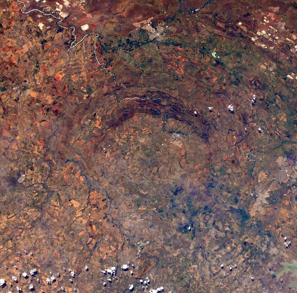
Vredefort with it’s arc of hills. The semicircle has a diameter of some 25 km. Source: ESA
The dispute may seem surprising to us, as the evidence for an impact origin was actually quite strong. But remember, up to the 19th century it was not known that stones could fall from the sky. Then in 1803, a meteorite broke up over L’Aigle in Normandy and showered the town in some 3000 fragments. Jean-Baptiste Biot investigated and found that the physical and oral evidence agreed: these stones had fallen. But to go from there to the idea that those stones from the sky could create geology remained a step too far. There was no need to call upon the heavens to do things the Earth was perfectly capable of itself. There were enough other processes that could cause ring-like structures: volcanoes, intrusions, erosion. Even the obvious impact craters on the Moon were long attributed to volcanism.
The scientific dispute blew up in 1980 when Luis Walter Alvarez and co-authors argued that the iridium anomaly of the time of the dinosaur extinction had an extraterrestrial explanation. He was already a Nobel-prize winning scientist who had worked on the Manhattan project, but he was not a geologist. It was seen as an unwelcome intrusion in the field and the arguments became emotional, personal and at times vitriolic. The argument about continental drift seemed little more than a minor disagreement in comparison.
The discovery of the smoking gun in 1990, when the predicted crater was discovered, tilted the discussion towards acceptance, but this was after Alvarez had died. The discussion now became about what had made the dinosaurs susceptible to extinction by impact. This is of course a valid question, but the strength of the impact hypothesis is such that any other cause was now seen as secondary to the extraterrestrial killer blow. It showed us that extinction events can happen to anyone, anywhere and at any time. But emotions still run high. A recent as the 1990’s, impacts were rarely covered in geology textbooks.
It was against this background that the discussion took place whether or not the Vredefort dome was an impact structure. The defining characteristic that identifies a structure as originating from an impact is the presence of shocked minerals. A falling mountain that impacts with a speed of over 10 kilometers per second creates extreme pressure. This gives rise to minerals such as stishovite, an extremely hard form of quartz that has only ever been found in meteor craters. Planes of deformation inside minerals are another telltale sign of massive shocks. Shatter cones are also an important sign of impacts. They are rocks with lines that form a cone shape, with the top of the cone shape pointing towards the centre of the impact. They require high shock pressure, but not as high as some other minerals: they can also form in nuclear explosions (something else not commonly considered in geology). Shattecones are widespread in Vredefort.

Planar deformation inside a microscopic mineral. Source: Earth & Life, McCarthy and Rubidge, 2005 (Struik publishers)

A shatter cone. Source: Bevan French, Traces of Catastrophe. https://www.lpi.usra.edu/publications/books/CB-954/CB-954.intro.html
All this evidence for Vredefort had been known by 1978, and in hindsight it was compelling. But geologists take their time – after all, they work on geological time scales. And there was a commercial angle. The gold fields of the Witwatersrand also ran in an arc around Vredefort, albeit much further out than the Vredefort dome. When money talks, scientists become cautious and are wont to stay away from disputes.
But the data spoke loud and clear, and by the mid-1990’s the Vredefort dome was largely accepted as an impact structure, with an age of 2.023 billion years, give or take a few million years. The accuracy of the dating is remarkable. Clearly, the land itself must be even older, and indeed it is: the basement rock here is 3.2 billion years old. The Bushveld complex which gave rise to the mineral riches and lies east of (and not within) the impact structure is older, and lived through the impact. So did the gold deposits.
The gold mines are spread over a region called the Witwatersrand Basin. The Witwatersrand is a 200-meter high plateau, 100 km long and 40 km wide, which runs from a bit northeast of Johannesburg to the southwest. The name is used both for the plateau itself and for the steep escarpment on the north side. The Witwatersrand Basin lies to the south of this and is a larger region: this is a sedimentary basin which was a shallow sea around 3 billion years ago, when the gold became deposited. The Cradle of Humankind lies within the basin. The Vredefort Dome is at the centre of this basin, although the two were not related: the impact came many hundreds of millions of years later. The gold mines are largely along the Witwatersrand at the edge of the basin,

The Witwatersrand Basin. Source: Tucker et al., A Review of the Witwatersrand Basin, Episodes, 39, 104 (2016)
Size
The Vredefort Dome is an uplifted area, 50 km across. (Erosion has long removed the uplift, so now it is an area where the deeper granite rocks have come to the surface.) Around this dome is a collar with a diameter of 80 km, consisting of younger rocks: sediments and lavas. This would seem to be the limit of the original crater. But there are larger concentric features as illustrated in the figure. How large really was the original crater?

Source: Tucker et al. 2016
To answer this, we must look at how impact craters, especially very large ones, form. But first, let’s have a look at the region.

Source: https://www.vdome.co.za The river is the Vaal.
The arc of hills around Vredefort look remarkable in the images. They consist of sandstones, not surprising in a sedimentary region. But where in the general region the layers are approximately horizontal (although there is a bit of a tilt), in the hills the layers are nearly vertical. Originally this was several kilometers below ground, by the way. Everything higher up, including the crater wall and bottom, have been eroded away. Something upended these rocks and only these rocks, while deep underground.
There are quarries near Parys, within the uplifted dome. They reveal granite – this is after all uplifted granite. The image below shows a side of the quarry. The light grey granite on the left is the original base rock which formed 3.2 billion years ago and was tens of kilometers underground. At the centre and to the right is a different band of rock where the granite is broken and surrounded by a dark, smooth rock. The second picture shows a close-up of this. The pictures are from Mike Gaylard.


The black mass is glass. It is called pseudotachylite – the ‘pseudo’ part is because this should be a volcanic rock but Vredefort is not volcanic. The pseudotachylite formed when the shock from the impact pass through the granite rock, and melted it. The shock melt formed the dark rock; the granite blocks are the broken-up granite that fell into the melt. All this happened deep underground.
There is another melt type. When the crater formed, it became filled with lava which formed a melt sheet. This sheet is long gone: it has completely eroded away. But immediately after the impact, the ground was deeply fractured and the melt flowed down into those cracks. This formed deep dikes and those can still be seen. This is called a granophyre, and if you have never heard of that, join the crowd since it is rather rare. Some of the granophyre has osmium/rhenium isotopic ratios which appear to come from the object that created Vredefort, so the granophyre is in part extraterrestrial. The pseudotachylite is pure terrestrial granite.
How large was the crater? The granophyre is found only close to the impact centre, out to the ring of hills, within around 25 km of the centre. The ‘planar deformation features’ are seen as far as 45 km from the centre. And the shattercones are found out to 90 km, which is not far from Johannesburg. This has been taken as the size of the original crater, giving it a diameter of 180 km.
Again, it should be pointed out that this is not the crater itself: there has been between 6 and 10 kilometers of erosion. We are looking deep underneath the original crater. This is the reason Vredefort is called an impact structure and not a crater, as the crater is long gone. That makes it hard to define where the original crater ring was.
Shape

Cross section of the original crater. The dashed line shows the current level of erosion: everything above this level is gone. Source: Earth & Life, McCarthy and Rubidge, 2005 (Struik publishers)
Craters come in four different types, depending on size.
A crater up to a few km is called ‘simple’. It has a bowl shape and an outer ring and that is it. Tswaing is of this type.
Between a few and perhaps 20 km the crater is called ‘complex’. It has a shallower, flat bottom rather than a bowl, and has a central rise caused by rebound after the impact.
Eventually, the central peak becomes a central ring. The crater is now called a peak ring crater.
The larger the crater, the larger the central ring. Eventually this ring approaches the outer ring and the crater is now called a multi-ring crater. The diameters where the craters change type depends on the local gravity (it is different on the Moon and on Earth and also depends on the type of surface (rock or mud, for instance.)
(Strictly speaking there is a 5th type which is the first. These are the pit craters that are created when dust particles hit a surface. They only form in vacuum and have sizes of millimeters or less.)

Source: https://clrn.uwo.ca/clrn-research/impact-crater-formation-and-morphology/
There are only three multi-ring craters known on Earth: Chicxulub, Sudbury and Vredefort. In all these cases, it is hard to know whether the outermost mapped ring is or is not the outer ring! For Vredefort, it appears not to be. The true diameter of the original crater is thought to be 250-280 km. That makes it the largest one on Earth, just beating Sudbury. There is a fragment of an arc of the granite base rock found far to the northwest – if that is from the original crater rim, then it reached 300 km diameter.
Why is there only half a structure left? The structure is visible in the north, but the southern half is not seen. Actually it is seen in gravity measurements, but it is buried. The reason is the Karoo flood basalt (already mentioned): it covered the southern half, and the weight of the lava depressed the region. Just wait a few hundred million years. By then, the northern half will be eroded away but the southern half should appear.
What kind of impactor could it have been? A useful rule of thumb is that the crater is 20 times the diameter of the object that caused it. That is not a law of physics: it depends on what kind of surface was hit. But it gives a reasonable idea. That makes the Vredefort rock 10-15 km diameter. It was bigger than Mount Everest. Imagine Mount Everest falling down on your favourite location on Earth. It was like that.
Impact
It was worse than that. The mountain came down with a speed of some 15 kilometers per second. It passed through the atmosphere in mere seconds. Earlier, while in space, it would have been visible by reflecting sunlight. At a distance of 3000 km, it would already have been as bright as the moon. And well before it would have been easily visible at night to the naked eye – at least if it didn’t come in from the direction of the Sun. Even at the distance of the Moon, it could have been the brightest star in the night sky. That may have been one to a few days before the impact.
Asteroids tend to move on orbits that are not much faster or slower than the Earth, so the relative velocity was likely small, a few km/s. (Ok, that is fast for geology, compared to, say, continental drift.) As it moved closer, it came under the influence of Earth’s gravity and started to move faster and faster, falling down. At a distance of 3000 km, impact was only minutes away. At 200 km it began to feel the atmosphere and by 100 km it had formed a bright fireball, burning the ground below just from the radiation. Along a track of several hundred kilometres, everything was killed well before impact – or at least it would have, had there been any life there. Less than 10 seconds later, it hit. It was not heard: the impact was before the sound wave arrived because the asteroid came in supersonically, and to the unlucky observer the asteroid would have been seen first, with the sonic boom arriving a minute later being the least of their worries. (The is true even for the Chelyabinsk meteor where most injuries came from the atmospheric sonic boom arriving a minute later. If you see a large meteor, stay away from windows for the next two minutes.) (But don’t worry about this if it is an asteroid.) If the observer was able to continue observing, they could have heard the asteroid safely moving away from them – because the sound from the more distant, earlier parts of the trajectory arrived later.
The impact was extremely energetic. The shaking was equivalent to an earthquake magnitude 14. (I don’t know what that feels like either. Very roughly, at a distance of 10 km, objects would be thrown into the air with a peak acceleration of 10g.) At a distance of 300 km, the earthquake would arrive after roughly a minute. Ballistic rocks thrown out by the impact arrived shortly after. The atmospheric shock wave arrived after 5 minutes. But the radiation from the rising fireball of the impact got their first, moving at the speed of light.
The underground explosion blew a rapidly growing hole in the Earth. The explosion occurred kilometers below ground but it did not penetrate into the mantle. The rebound was from granite from deeper levels in the crust, not mantle material. That would take an impact even larger than Vredefort.
The approximate sequence of events is shown below. This is taken from an old simulation of a large impact (not as large as this) hitting Berlin. (It was made by German scientists eager not to endanger the rest of the world.)

20 seconds after impact, the hole is growing and ejecta are spewing out from the side of the growing crater. The expansion continues for two minutes. By that time, the ground at the centre of the crater, which was pushed down by the force of the explosion, is rebounding and just like a drop of water falling in a bath, creates a central bulge. In a complex crater, the rebounding bulge solidifies at this point to form a central peak, but in a very large impact this rebound itself falls down again and in a second rebound will create a ring around it – the inner ring of what will be a multi-ring crater. The crater at this point may still be expanding.
As the deep crust is pushed down, it will in return push the ground much further out upwards. This combination creates a central bulge (the Vredefort dome), the deep crater around it, and around that a higher rim from this outer uplift.
Matter that is evacuated from the crater flies through the air. Much of it is fragmented rocks, although ‘fragmented’ should be taken with a grain of salt. Rocks that themselves would be decent-sized hills are thrown hundreds of kilometers distance. They are joined by much smaller fragments, down to dust. It creates a blanket around the crater which even 500 kilometers away is still 100 meters thick. Other flying material comes from the melt caused by the asteroid. These droplets rain down on top of the debris layer as minute glass-like spherules. They come in two forms, fragments that are ejected in ballistic trajectories and fall back down from space over several hours, and ones that drift in the atmosphere and are carried by wind – lots of wind after such an impact. The ballistic droplets may fall down thousand of kilometers away. The entire world was hit by a Noachian deluge of rock and glass.
But perhaps most damaging was the heat released by the impact. The spherule rain would have heated the upper atmosphere to a temperature of 1000 K. The radiation from this would be as strong as 10 times the radiation of the midday sun, comparable to an oven. The air temperatures, especially in dry air, are less affected by this one-hour heat pulse, but any surface exposed to the sky would be baked.
Remains of the day
These events happened long ago. Erosion has removed the rim, the crater with its melt sheet and the inner ring, as well as all ejecta. What we now see is the granite dome, the bit of the uplift which stayed below ground and which is surrounded by younger material (where the ground was flexed down), and another outer ring where deeper material has come up. But what was at ground level 2 billion years ago is long gone. Don’t expect to find spherules here!
But millimeter-sized spherules from Vredefort have been found, just not in South Africa. They were found in a 10-cm thick layer in Karelia, north Russia, with spherule shapes indicating that some came in from space rather than wind. Both the age and the composition point at an origin in the Vredefort impact: the iridium, platinum and various isotopes indicate that they are from an impact and are not volcanic. Russia is a world away, 10,000 km from Vredefort! But of course, the world was different in those days and continents were not where they are now. Models of the impact indicate that a 10-cm debris layer could have formed as far as 2500 km from Vredefort. Clearly, Russia (or better, the fenno-scandinavian shield) was much closer to South Africa in those days, but this is still a long way apart.
Spherules have also been found on the southwest coast of Greenland. Their date is more uncertain and they could come from either Vredefort or Sudbury. But the chemical composition is different from Sudbury and points at Vredefort. The layer containing the spherules is one meter thick and extends over 25 km. The layer appears to have been deposited below water, by high-energy waves or a debris flow which also deposited rocks up to 1 meter in size. It is tempting to associate this with a tsunami induced by the impact. The Vredefort impact itself was on land, but the pressure wave would still have whipped up the oceans into a frenzy. However, this is speculative. The region can also have been destabilized by the massive earthquakes caused by the impact which would have rocked the entire world. The Earth would have rung like a bell for weeks.
The layers below and above the spherule layer are a bit different from each other, indicating a change in the ocean chemistry. This could have been caused by a lot of continental debris entering the ocean but this also remains speculative.
Life
We know very little about the impact on the rest of the world. Nowadays, such an event would be devastating worldwide, as was the case of the Chicxulub event which was smaller than Vredefort. Imagine the entire world on fire! But 2 billion years ago, the continents were lifeless and without life there can be no fire. The dust from the impact would have dimmed the planet for anywhere from a decade to a century. Sulphur may also have been released as the impact hit an old sedimentary basin, though deeply buried at the time, causing additional cooling. This was counteracted by the sheer heat from the impact. But the oceans are more resilient than the land and take much longer to cool down. There is no evidence for a mass extinction at the time, but this means little, seeing how limited the fossil record from this age is.
We do know that life survived. The Earth was devastated, but not destroyed. There would have been a difficult decade for bacteria, algae and other single-cell life forms, but they pulled through. How many did not make it, we may never know. Stromatolites would have been destroyed but they re-established themselves. But if any multi-cellular life forms had developed (something we don’t know but possible), those did not survive and they had to re-evolve.
Gold of Humankind
South Africa is an amazing country. Within a relatively small area it has the Bushveld with the richest mineral deposits in the world, the gold fields of the Witwatersrand responsible for 30% of the gold mined in the world, and the largest impact structure known on Earth. And of course there is the Cradle of Humankind with the remains of ancient Mrs. Ples and 30% of all other known hominid fossils. Is there any relation between these?
Mrs. Ples and Vredefort are 2 billion years apart, so this coincidence seems coincidental. That Mrs. Ples was aware of the gold and platinum also seems unlikely. The Bushveld intrusion happened shortly (50 million years or so) before the Vredefort impact but we know that the two were unrelated. The intrusion is outside of the original crater but some dikes intrude into the region. Those dikes show the shock impacts, meaning that they were in situ and had solidified at the time of the impact. The orientation of the magnetism in the Bushveld intrusion also shows that it predates the asteroid. So this was coincidental. It is just that some countries have all the luck.
But how about the gold? Why are all the goldmines located in a semicircle around the Vredefort dome? And it is indeed all the goldmines: a third of the world’s gold comes from the Vredefort crater ring. The map below shows the goldmines in blue. How can this be accidental? The gold itself is solidly terrestrial, though. It was put done many hundreds of millions of year before the impact. Do asteroids hunt for gold too?

The Witwatersrand basin. The gold mines are shown in blue
The answer is a bit more down to earth. Remember that some of the regions were pushed down by the impact, and some regions came up. The outer rim and central dome came up, and the main crater went down.

This image shows the effect, The reddish colour depicts the deep granite base rock. The yellow layer is the one that contains the gold. This layer was bend upward near the outer edge of the crater. The black dashed line shows the current surface level. The gold mines are located where the yellow layer approaches the current surface. There is probably much more gold elsewhere in the layer, but it is deep underground and we can neither find it nor mine it. It became minable because of the uplift by the Vredefort impact, the 6 to 10 km of erosion in the two billion years since – and because of other accidents such as the fact that the Karoo flood basalt left half the impact structure uncovered.
You may note that the yellow layer also reaches the surface near the centre, immediately around the Vredefort dome. And indeed, there are some gold mines in the hills around Vredefort. But the gold veins are much more broken up here and are difficult to find and follow underground, so the mining was abandoned here a century ago.
The twist at the end
There is a final twist. The gold deposits are located in a layer of sediment that formed in shallow water. The sediment is not just gold: it is mainly limestone deposited in a shallow warm ocean, as is found in many places around the world. Limestone dissolves in rain and forms caves. The hominid fossils of the Cradle of Humankind were found in those caves.
Hominids -us included- have always been attracted to shallow caves. Just look at how we build our houses which resemble large, airy caves with a view of the outside so we can see the neighbours and other threats. The Cradle of Humankind is there because of the uplift of this sedimentary layer by the Vredefort impact, and the fossils survived because they were protected inside those caves.
There is a relation after all: The Vredefort impact built us our first homes. Caves as safe as houses.
Legacy
The Vredefort impact has left a lasting legacy in South Africa. The impact shaped the country and made much of its wealth accessible. It may not be immediately obvious on the ground and it takes effort to see the signs of the event, but it is well worth that effort. This designated world heritage site is one of the wonders of the world, albeit a scary one.
If an event like this were to re-occur, humanity would go the way of the dinosaurs, and would do so in the way of the dinosaurs. Vredefort helped create us, but it also shows us our fragility.
Albert, June 2025

Source: https://www.vdome.co.za
Normally there would now be a set of papers or reading list. Instead, there is a link to a youtube presentation by one of the main researchers working in the field (literally so, in this case). You will find a good overlap with the post, and for good reason. You may even recognise some of the figures.


(KWcam, live)
Looks like one of the cams is now online (not on the interactive map but in webcam part of media section).
I would expect for F1cam to follow, but isn’t really doing anything yet.
Laser is back too, the elevation of the crater floor is about 982 meters, presumably the same area it looked at before where the old lava lake of 2022 was. So well below both vents.
At this elevation, the lake is 464 meters deep. Maybe 20 of that is solid at the edges and top, but theres certainly way over 400 meters of liquid lava that most likely has barely cooled with that kind of thermal mass.
If the crater floor is about 980 meters elevation, and the rim on the north side is 1070 meters, then there is 90 meters left to fill before it overflows that way. And maybe 120 before overflowing south. Its also about 360 million to 400 million m3 away from overflowing, a lot less than I thought (600 million) so at current rates of 0.22+ km3 of lava a year it will probably be overflowing at the end of next year, and southwest probably starting in 2027. Its very unlikely the 2018 caldera will see its 10th birthday…
It also means if the pressure is too high to actually do that and magma goes elsewhere or even the caldera drains, that will happen probably within 18 months…
That’s 30m higher than the highest volcanic peak of Hesse: Wasserkuppe https://en.wikipedia.org/wiki/Wasserkuppe
(Oligocene to Miocene)
So Chad, You said these signals were comparable to Kilauea. Throughout the last month, there was a substantial shift of 800 microradians and the deformation at the Chiles cone proper expanded massively.
If something like this happened at Kilauea, what would you say of it?
Its not really comparable, Kilauea has the most fluid lava of any normal volcano, and a very cracked edifice, so lava will leak out of basically anywhere before building much pressure. Chilles Cerro Negro is a viscous volcano in thick crust and an active forming mountain range, so almost the opposite. 800 microradians is only 80 cm from 1 km away, which is baby steps for viscous laccoliths (cryptodomes). Kilaueas lava when it erupts is probably only a couple hundred times more viscous than water (more after flowing away) but the lava flows at CCN look like glaciers of rock, maybe a million times more viscous and debatably even a liquid at that point really…
As a side, it happened over too long to show on any of their graphs in a single picture, but Kilauea did probably show over 1500 microradians of tilt increase at its summit from September 2023 to December 2024, that was probably only possible because it was refilling after 2018 drained it away.
In a way too, 800 microradians of tilt doesnt mean anything unless the location is factored in. The 800 only means something 1 km away lifted 80 cm, or something 10 km away lifted 8 meters but that would probably be pretty obvious 🙂 There is also direction of tilt, which way is the uplift.
I agree with you CCN is probably going to erupt eventually, but viscous volcanoes do extreme deformation easily, if Kilauea did this right now then we all picked the wrong volcano for the next Laki, but any average lava dome volcano could probably do this before it does anything. CCN might need to do thpusands or even tens of thousands of microrads to be clear it is magma about to surface. Im not sure if that applies to an explosive eruption, but if the magma was particularly gas rich I think it probably would have erupted already.
Chiles-Cerro negro is such an insane volcano, I’ve seen it do a 40,000 microradians shift in a years time but the SGC hasn’t been reporting data from that station in months so who knows what’s happening there. The reports on the deformation data are so incomplete that I can’t make any solid conclusions on what’s going on. I can’t contextualize these new developments since some of the uplift data contradict each other, and I am only getting half or a quarter of the inclinometer data.
There are likely few volcanoes with magba more viscious than Chiles-Cerro Negro right now, and analysis into the systems past products have shown that it’s magma is gas-rich indeed. It’d have to be considering it’s over decade old dike is still active and kicking!
What interests me currently is the expansion of the deformation field and the constant VLPs and Tremor. For the first time, the volcano is actually starting to produce magnetic disturbances. The current swarm has been the weakest but it’s been interesting and has produced more VLPs and Tremor quakes than any other swarm before it.
40,000 microradians is 40 meters 1 km away, that probably would have been noticed if it was ground deformation, so either an error, or the instrument was moved. Doesnt change the situation of it waking up but numbers like that are suspect. If that much movement happened anywhere near any active volcano that isnt already erupting theres no way it would be hidden, someone would have taken a picture even if there was some conspiracy to hide it.
Alternatively, if it is real, then there is probably a cryptodome growing somewhere, which is probably a sign that an explosice eruption is unlikely to be serious unless it is rapidly decompressed like at St Helens.
I don’t even know anymore, i almost don’t care. I thought it was an error, but they never corrected it after 3 years, and once again, the fact that they didn’t change it and never clarified on the situation is frustrating. Insar data is unreliable; the GPS data sometimes contradicts each other. How am I supposed to work with this? Every year, something different happens and there’s almost never a conclusive answer. Deep LPs in 2020? Nothing. Massive shift in the Inclinometers in 2021 with a retroactively anomalous pause in seismic and uplift activity? Nothing. Possible subsidence surrounding the dike? Nothing. Massive Tremor and VLP spike over the last 2 years? “Shallow movement of volcanic or hydrothermal fluids are the likely cause.” Seriously, that’s it? A modest dike that’s somehow hasn’t cooled or solidified after 11 years and is still somehow producing unrest?
Everything about this volcano just seems so damn odd, it feels like there’s something missing that no one is trying to understand.
What is the first sign, if Mauna Loa begins with post-shield stage?
Mauna Kea has ~1km of postshield lavas that bury the shield stage caldera. If Mauna Loa also adds 1km during postshield stage, the summit will head towards >5km above sea level. The early postshield stage must still be very productive with 850 km³ of Mauna Kea (212 times Pu’u O’o) over a span of 180,000 years.
Its not abrupt, I used to think it was right on the edge but its showing no signs in its geochemistry. Mauna Kea also was probably a bit different, it has no rift zones and grew up high on the side of Kohala, and it is actually younger than Hualalai but more evolved. It also was never as productive as either Mauna Loa or Kilauea has been historically.
Hualalai also is much less alkaline than it sounds being described. The lava has 2.5% and 0.8% Na2O/K2O respectively, Grimsvotn is always stated having tholeiitic basalt, but the Laki lava is a very similar ratio, 2.6% and 0.4%. Hualalai also has twice the MgO content roughly, 9% MgO vs 5% MgO at Laki. By comparison Kilauea has 2.3% and 0.4% Na2O and K2O, and also 9% MgO primitive, and Mauna Loa 2.3% and 0.3% Na2O and K2O, and 10% MgO.
Hualalai does have only 45% SiO2, vs 49-51% for the other volcanoes. I think ‘alkalinity’ in basalt refers to the ratio of Na2O and K2O to SiO2, not necessarily the absolute content of those oxides in the whole rock. Alkaline magma has less SiO2 so needs more of everything else, I guess. Point is Hualalai is still very similar composition to Mauna Loa and Kilauea, its not some exotic magma that suddenly starts erupting one day, except the trachyte but that would take millennia to evolve and there would still be basalt too. The only trebds I can find actually looming at tbe data quickly, is Mauna Loa abd Kilauea actually have slightly higher SiO2 vs alkalis now vs in the earlier shield stage, so partial melting has probably increased over time not decreased, on average.
I guess very short answer Mauna Loa isnt about to change over, although it probably has reached its max size above sea level. Kilauea, obviously, has its big days still ahead. Mauna Loa is old but its not dying yet
ML will continue to grow, but most of that will be mass wasting off the SWRZ–that sector is unbuttressed.
I can’t see Kilauea doing much vertically until Kamaʻehuakanaloa and the next of the Kea line block the palis from slipping.
I actually think it is more likely Kama’ehuakanaloa will struggle to surface soon without Kilauea helping. Kilauea hasnt grown south much from its summit, theres even still preshield lava exposed in the seafloor in its slump zone. Majority of its growth so far has been eastwards, but the ERZ gravity anomaly is north of the active part so might indicate an imminent shift where the ERZ might be less connected, and most magma erupts close to or at the summit.
HVO says that the magma becomes more viscous during the postshield stage. This can only happen with either evolved basaltic Andesite or a Trachy basalt / basaltic Trachy-Andesite.
Real alkali (La Palma, Vesuvius, Nyiragongo) magmas are explosive, although they aren’t viscous. They are liquid, but very gasrich. The gasses dissolve with decreasing pressure and make the explosive eruption. Hawaiite https://www.mineralienatlas.de/lexikon/index.php/RockData?lang=de&rock=hawaiite https://en.wikipedia.org/wiki/Hawaiite is indeed a trachy basalt, but typical for posthield or rejuvenated volcanism?
Magma can get more viscous because lower supply leads to evolution and potentially large volumes of intermediate or felsic magma. But at the same time, Hualalai is postshield and just as fluid as Mauna Loa and Kilauea, and doesnt have any more trachyte. Mauna Kea is more viscous but its lava is more evolved, and it is also inland within the main thickness of the Big Island where the crust approaches continental thickness.
The main feature of postshield is the lack of a shallow magma chamber. The shallow chamber evolves quickly as supply declines and then you get trachyte or similar, before the upper system dies and gets buried. Hualalai has a high enough supply to keep its deep storage hot and fluid, Mauna Kea probably doesnt. I dont know about Haleakala, it is between the other two in viscosity, probably similar productivity to Mauna Kea but the frequency is much higher. I wonder if Kohala was taken over by Mauna Kea at some point due to proximity.
And not all Loa volcanoes develop a post-shield stage; in fact, possibly most don’t. Hualalai has the only proper postshield of a Loa volcano. West Molokai was neutral volcano (neither Loa nor Kea). Mahukona it’s unclear if it even had a shield at all, so it might be considered to be a pre-shield only volcano. Lanai and Koolau never had any postshield, they went out being tholeiitic, and Lanai even more tholeiitic than Kilauea and Mauna Loa (it likely formed a Loa-Kea pair with Haleakala volcano about 1-6-1.4 Ma, at the/a peak of Hawaiian volcanism. Kahoolawe also had barely any postshield, and both Lanai and Kahoolawe still preserve their calderas produced by shallow shield-stage basalt chambers. Lanai’s caldera is huge, about 13 km long, way larger than present-day Mauna Loa, it filled to the brim along the west side, but still preserves the eastern rim.
So we can’t know now, whether Mauna Loa will do a postshield stage in future or will retire silent. Do we know whether Mauna Loa is past its peak acitivity of shield stage or before? Are the Loa volcanoes like Mauna Loa usually less productive than the Kea volcanoes like Kilauea now?
Chad is right about the maximum height. The mountain can’t support even its current height. It is sinking by a few cm per year, because the mantle underneath is pushed down and sideways. This is compensated by the new magma that is arriving, which keeps the height stable. Change the magma and the mountain will start to sink
Mauna Loa has flat slopes now. During postshield stage the relatively explosive eruptions (Hawaiian-Strombolian) make the slopes steeper and add mass on the summit. So I’d expect that the volcano mountain can still bear some vertical growth without a collapse or instability. But it’s right, that the weight of Hawaii’s volcanic seamounts lets them sink down a bit. Without the conter-force of the plume, they sink down like the Emporer Chain atolls.
Kilauea UWEV tilt has broken the trend, and there was a small earthquake on the east end of the caldera again. SDH has no change so its not related to magma supply, maybe asmall amount of mag.a leaked into the ring fault and moved some stuff.
Ironically the iron in the knife is older than the rocks, since it was produced by a presolar supernova.
These Canadian rocks may be the oldest on Earth (Phys.org, 26 Jun)
Quite pretty they are too. Interesting to know what the minerals are that are present in the alternating grey and white bands.
New map of the lava thickness at Kilauea for this eruption up to about 2 weeks ago. The vents are about 100 meters elevated above the pre-eruption terrain.
Based on this map, the elevation of both vents is now about 1020-1030 meters. The spot the 2024 fissure opened through was slightly over 3000ft elevation, or about 920 meters, add 103 meters and then a bit more for subsequent E25 and E26. If anything it is probably over 1030 meters now after the huge growth in the last two episodes.
Still about 100 meters to go to reach the elevation of the caldera rim, ignoring the growing tephra cone. But at this rate this could happen by next year, if fountaining of similar intensity stays the dominant style. My earlier volume re-estimate is outdated now though, if the average of 955 meters is taken then the 2018 caldera is on average about 110 meters deep from the north edge now. Which gives a volume of 440 million m3. So its probably at least 2 years off of filling to overflow.
Can someone edit my name back to Chad, thanks 🙂
Done as requested – admin dragon
The USGS posted a GIF showing the growth of the tephra cone through the recent 26 episodes:
Impressive to see for sure.
The tephra hill is around 20m high, that’s comparable to sand dunes on the coasts.
Spatter show now:
https://www.youtube.com/watch?v=BqmpkUdMtyA
https://youtu.be/BqmpkUdMtyA
E26 was preceded by spattering like this and a pause of 1-2 days. Maybe this spattering is a first attempt to do an episode that fails.
A little different news.
“Fireball meteor believed to have crashed into Georgia home after sending shockwaves across Southeast”
“Images of damage to a home in Henry County, Georgia, southeast of Atlanta, showed a hole in the roof and ceiling along with rocky material and other debris on the floor inside the home.”
I did not see or hear this, but this county is only around 50 miles from us.
https://www.foxweather.com/earth-space/daytime-fireball-sighting-southeast-june-2025#google_vignette
New images from Kīlauea.
I wonder if the moving tephra mound within the caldera would eventually block lava, initially, from moving to the south or southeast as this thing builds each episode, only to move and crack like a glacier, slowing down until the next episode comes. Also, it might provide a base for the connection between the mound below and above, burying the wall in the process…
I think it will merge with the cone on the rim probably pretty soon at this rate, and form a massive hill that might end up becoming the new summit this year. Pu’u O’o got over 250 meters tall, a similar cone grown on the south caldera rim now would have a summit at about 1400 meters elevation.This angle provides a view not really offered by any of the cams, a perspective on how much the vents are elevated compared to the rest of the floor, and how thick the tephra actually is.
I think too, it needs to be considered the possibility that the growing cone at some point soon might start repeatedly slumping into the vents and burying them, but in the process as episodes break through again it also rapidly builds the vents higher far more than would happen otherwise in that time.
That is kinda what I was thinking with the mounds collapsing into the vents and blocking them, although that might mean they’ll change fountain direction or even make them sort of corks in a bottle, allowing more pressure to build until the blow. Kīlauea Iki sort of had that same situation, where in one episode it moved further up in elevation and, in another episode, sprayed spatter and tephra on the other side of the crater before correcting itself.
This could happen any time at any point, but it is also possible new vents could emerge, like the lower north vent in Ep. 24 (I think) or the many vents around the main south vent. Those might change the whole eruption dynamic here.
Im not sure the fountain angle will matter much as the wind tends to be the main factor building the cone, fountaing angle would matter more for where the fallout spatter and associated flows would go though.
Its also still entirely possible even likely that both vents swap being the dominant one, it has happened already a few times, and the south vent is just as wide open as the north vent, and doesnt shut off at the same time either so their divergence is deep and they might not even be connected at all, two separate parallel open conduits
We should find out shortly. it is building up to the next fountaining episode.
The dominant factor in building the cone is the height of the fountains.
The black tephra sand dune is towards the southwest direction, because NE trade winds move ash and lava fountains towards the SW.
Tephra and lava fallout of lava fountains have filled the SW bay of the caldera, as the lower photo shows. On the left side of the bay was 2022 or 2023 a “Vent on the cliff” that erupted lava there.
Until now most lava has run east towards the inner caldera. This may change, if the vent grows above the caldera rim. But then it’s uncertain how stable the cone will be. It’s possible that we get collapse events, because the fast growing cone balances wobbly above the vertical cliff of the caldera.
Regarding this gif of the cone growing on the rim, theres actually a pretty big detail, the cone is basically only from the last couple really tall fountains, and its unlikely any of the episodes that were less than 200 meters contributed much tephra at all. Going through the frames, the cone is almost entirely absent until the last 6 or 7 frames, and appears half its height was in E26 alone…
So the cone is actually growing at probably as much as 10 meters PER EPISODE… Its likely the fountains will stay tall for a while and may only get even taller, so its actually entirely plausible the cone exceeds the current height of U’ekahuna within a few months at this rate.
I did notice something potentially very significant in that lower picture though.
https://i.imgur.com/1oHnEIg.jpeg

Its hard to see but there seems to be two possibly glowing cracks above the vents, where the steaming was reported on the walls the other day. Its probably just red oxidised tephra but it doesnt look the same colour to me.
Even if it is incandescent, its not an automatic new vent ir SWRZ intrusion, jt might just be hot from last episode. But its interesting still.
I’ve also wondered about the area of “thousand smokes”. Maybe a future central crater or even lava lake?
HVO has already published a warning concerning next episode: https://www.bigislandvideonews.com/2025/06/28/volcanic-activity-notice-issued-for-kilauea/?fbclid=IwY2xjawLOAwhleHRuA2FlbQIxMQBicmlkETBpcWZnUTRwWTdnVkd3Q2pPAR4IAIrUxiFj7rCHZkBz4AMPj-ONy9dLZDIUbK004f4uzVnxX4kb_oAwpHlUPw_aem_N8venfTg2BNxbu8Tfz9XyQ
“low-level activity for Episode 27 began at around 7:27 a.m. HST on June 28. Sustained lava fountaining is likely to begin on June 29 or 30” Wind direction remains the same, so we can expect that the volcanic sand dune is going to grow again.
If this is a new conduit it will eventually be host to both of those I expect, as was the case of Pu’u O’o. But its unlikely that the vents will become a crater unless magma is withdrawn from them to allow collapse, which is probably years away still. Up until that point theres really no mechanism to cause the fountaining to stop.
Magma was never deep below the surface between the episodes. We can call it a “magma lake” at an unkown depth. If the ground above it collapses one day like 2008, we may get a lava lake like this, but probably more energetic and exciting than 2008-2018 that had nearly zero output.
Looking at the Icelandic map today, it might appear that the ‘Inside the Volcano’ tour might get more than they bargained for.
https://www.getyourguide.com/reykjavik-l30/inside-the-volcano-guided-hiking-day-trip-t33718/
Seismic rumbles in the area…
£300/person!
4 hr hike?
ye gods, I cannot imagine how much a beer costs ….
2.7 euro at state bottleshop for 0.5L.
https://www.whatson.is/beer-prices-in-iceland/
One of of the sites I like to check each day is the Icelandic broadcaster RÚV. The entire population of Iceland is about the same as the obscure and rather boring Aussie city that I live in. Yet the drama in Icelandic news is dramatic!
Today it’s the Leaning Tower of Gjögurtá. Yesterday it was the Heart Shaped Traffic Lights. Icelanders are very entertaining.
As for me I avoid beer, not least because there’s whole province worth of excellent wine a short drive to the west of my house.
Hunter Valley wine (wiki)
My daughter suggests this as a UK alternative (I prefer iceland myself).
https://www.google.com/search?client=ms-android-samsung-ss&sca_esv=60a23ae29e3c6b22&sxsrf=AE3TifPqJygJ4Vk12DiVC2YjzL071uZ2_Q:1751183393189&udm=2&fbs=AIIjpHz30rPMyW-0vSP0k1VTNmO_kCOARpjPjQRkBWH2HwUIz5XUSIJvSK0oms7XOxizDlkGhD-Y24a-VmufGWrnriDKUVb9LsH2YdQcKhTwVjjd11jO5ZBTi3_CdGw6jo_F1UjT8T1U8auZv-QWUlZX2m4Kvh15Qmg0JYpFQwf7O8QV86LBb37wWLzbRSYFXifCIldz_d02Ptv_qjBGYAjijVGY3K1-4R1lWlTRkflnEkhybiHuOsg&q=traffic+lights+trafalgar+square&sa=X&ved=2ahUKEwjytdnAkpaOAxVzYEEAHQgsPWAQtKgLegQIDxAB&biw=360&bih=645&dpr=3
Probably not included
Japan’s volcanoes are very active now:
– Kirishimayama had on 22nd June the first eruption since 2018. ” An eruption detected during 1637-1755 on 22 June produced an ash plume that rose 500 m above the crater rim and drifted E. … On 23 June the Alert Level was raised to 3 (on a 5-level scale)” Usually this volcano does VEI2 eruptions, but had a VEI4 in 1235
– Kuchinoerabujima (difficult to pronounce) has had an increasing number of shallow quakes and inflation since April. “135 volcanic earthquakes recorded during 2-11 June … The Alert Level was raised to 3 (on a scale of 1-5)” They warned about the risk of ejected blocks and Pyroclastic Flows. (did VEI4 1933-34)
– Miyakejima only earthquake unrest. Last eruptions (f.e. 2010) were VEI1, but can doe VEI4
– Aira usual eruption (did historically up to VEI6)
– Suwanosejima strombolian eruptions (can also do VEI4)
With reference to the very latest internet hype about a prophecy of doom between Japan and Philippines on 5th of July with a big thing to happen, I got intrigued to monitor closely the earthquake swarm in the Ryukyu area, which started on June 21st and is ongoing right now and it looks quite massive with a lot M3-4 and several M4-5 quakes.
And I wondered, if probably an undiscovered magma chamber could sit below this area and is now running up for some bigger eruption? I mean the Kikai caldera sits just north of this area.
Is there anybody with expertise on that? Thanks.
A VEI4 eruption seems possible for Kirishimayama. I don’t know how dangerous this would be for populated areas around it. Sometimes an ugly VEI3 on the wrong place can be worse than a good VEI6 (f.e. Novarupta 1912) in remote areas. 1566 an eruption of Kirishimayama with VEI3 killed “many people”: https://www.data.jma.go.jp/vois/data/filing/souran_eng/volcanoes/087_kirishimayama.pdf
1235 they didn’t report about fatalities, although it was a VEI4 eruption.
Small subglacial eruption of Katla caused probably a “glacier run” (jökulhlaup) 2024: https://www.ruv.is/frettir/innlent/2025-06-27-eldgos-undir-jokli-i-kotlu-mogulega-orsok-jokulhlaups-447183?fbclid=IwY2xjawLN-klleHRuA2FlbQIxMABicmlkETBpcWZnUTRwWTdnVkd3Q2pPAR65XHYVJWvvIT8IGvDBYey0jR3MPxe2gB8ZlVJDWjRPSeLNlmP8NVFDkDYZAw_aem_dfBIcd3ZmAU2TQTdZl2SWQ
They had indicators that there was 40 degree warm water, either because of geothermal heat or a small eruption. Small subglacial eruptions happened 1999 and 2011. In August 2016 was a short tremor event (failed eruption?).
Since 1999 we’ve probably had three minor eruptions. Before 1999 there is a gap until 1955. Was Katla less active before 1999 or was monitoring weaker? Can an increasing frequency of minor subglacial eruptions precede the next big eruption?
Kilauea episode 27 comming up very soon when the inflation starts to sourge again like crazy but for now pre – eruption spattering and gas venting. Here is a very strange map: the world climate zones including the ocean areas around land which are normaly never mapped. I guess over the wast oceans that store both heat and cold then seasonal temperature variations may barely exist at all … being very unseasonal enviroments compared to the continental areas at temperate latitudes.
https://www.reddit.com/r/geography/comments/1j1u0z7/climate_zones_over_the_oceans_is_humid_climate_on/
I have not looked at a GPS station in a while….but I just looked at a several of them and they are reporting again. AHUP, OUTL, BYRL.
It looks like this might be the start of Ep.27 fountaining.
https://www.youtube.com/usgs/live
Yes its much too high volume to only be gas pistoning. That has a sequence of rising then overflowing, but fountaining is brief and stops the overflow. This is low fountaining with high volume, the upper maybe 1 km of the vent that has degassed and is capping the gas rich magma below. As I type this it has gotten stronger, its very probably going to go far over 300 meters within 20 minutes.
The fumaroles up on the wall to the south of the vents, left on the V3, they are interesting. It was brought up before during a time everywhere was steaming so it could have been weather, but the colour of all the clouds right now has the characteristic pale blue so there might well be magma going that way, I dont know if the tephra piled up in that area would be degassing in that manner by itself.
Once the gas rich column below gets decompressed it will rush out into a +370 meters high lava fountains, it will be very intresting to watch the stations on the SWRZ for any signs of deformation, uplift or tremor signs that magma is leaving into these parts of the caldera complex but likey is not happening and the moment but the blue gas line is very intresting
Fountaining is really increasing dramatically.
New post is up! How high can it go?
https://www.volcanocafe.org/volcanoes-limits-to-the-growth/