
Guest post by Tallis
Humans have always had some fascination with rankings, some of the most popular videos and articles on the internet have dealt with comparisons and rankings. However, this doesn’t mean that it is just another useless fad, on the contrary, a well thought-out “Top 10 list” can be very informative. For disasters, we have created scales, and we are all very familiar with these scales, the Fujita scale, Safir-Simpson scale, Moment magnitude, and the VEI scale. Just like us, these scales are imperfect, they don’t factor in all of the variables, most of which you would only know right when the disaster is taking place or afterwards but they get the job done. We don’t need to understand all of the variables to understand that when an EF5 is coming, that means get into a basement. However, volcanoes aren’t like most disasters, we don’t really see disasters that produce such varied and extreme consequences on so many levels. For example the Laki eruption, a VEI 5, killed more than 30,000 people directly, and the explosivity of that eruption had negligible effect on the actual population. The VEI scale is a great scale for scientific purposes, easy to understand and easy to apply but when it comes to the effects that is where it’s reliability breaks down somewhat. For instance a VEI 7 can cause less direct death and damage than a VEI 3.
My VSI scale will have it’s focus completely dedicated to the consequences of eruptions, and will serve as an excellent way of estimating the scenarios born from volcanoes. What does it mean? VSI stands for Volcanic Societal Impact, and it’s focus is dedicated solely to direct volcanic impacts, so climate consequences are not a factor. Climate effects of larger eruptions are chaotic and unpredictable. When a large eruption takes place, by the time it takes to get a general idea of the volcanic winter, the eruption could have already ended. The damage done by a on-going eruption does not include subsequent climate effects (although it could be factored in for historic eruptions).
For the VSI scale, lahars, ashfall, tsunamis, landslides, shockwaves, gas emissions, glacial flood outbursts, and pyroclastic flows can all be factored in with relative ease. The two primary factors are range and impact. Both are split into 4 categories, Short range: 0-30 km away from the volcano, Medium range: 30-70 km, Long range: 70-100 km, and Distal: 100+ km. The impact categories are, None or negligible, Minor, Moderate, Severe, and Catastrophic. If climate consequences were to be factored in, they would go under the Distal range.
The scale goes from 0-12, but how would we discern whether an eruption is a VSI 1 or 12? We think about what impacts the eruption would cause over any of the ranges listed above. We convert the impact categories to the numbers 0, 0.5, 1, 2, or 3; we then add all the numbers to get where the eruption lies on the scale. For instance, the recent eruption of Fagradalsfjall would be VSI 0 as it has negligible consequences on all ranges, so 0+0+0+0=0 and a truly Catastrophic eruption be 3+3+3+3=12.
Now this is where the problem shows, the definition of a moderate, severe or catastrophic impact would vary depending on who is using the scale, which would lead to some conflict on where to place certain eruptions, the Enhanced Fujita scale has similar issues. Another issue is that the scale doesn’t tell you what the primary hazards are, a VSI 8 over land and VSI 8 over water will have different hazards. Another issue is that this scale focuses on impacts and with some good preparation, the impacts of a massive eruption can be reduced substantially and as such the eruption would rank lower on the scale then a smaller eruption that took place without good prep. The largest eruption of the 20th century, the eruption of Novarupta ranks at 1.5! Needless to say, the population and infrastructure surrounding the volcano plays a crucial role in finding out what it’s potential ranking is.
Now that I’ve explained the scale, I will rank some past eruptions and I know the perfect place to start!
The 1883 eruption of Krakatoa
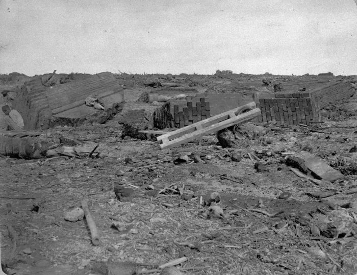
The town of Anjer, after the eruption
This eruption is one of the most infamous in all of history, and it was the first disaster to grab global attention, so naturally it’s the perfect place to begin. The eruption produced several explosions that were more energetic than most nuclear weapons and while the cause of the explosions are fascinating, it doesn’t matter for the ranking. Most of the deaths were caused by the four massive tsunamis produced by the eruption. Each explosion also caused massive pyroclastic flows that reached distances of up to 40 km in some areas. This eruption is one of the deadliest in Human history killing more than 36,000 people. In Anjer alone, 7600 local inhabitants and 14 Europeans died.
This volcano ranks pretty high for a low end VEI 6. The Short and Medium range impacts were all Catastrophic due to the tsunamis and pyroclastic flows, Due to the tsunamis, the volcano produced severe Long range impacts, and the ash fall and the tsunami would’ve produced moderate distal impacts. So this eruption would a VSI 9 (3+3+2+1=9)
The June 1991 eruption of Pinatubo
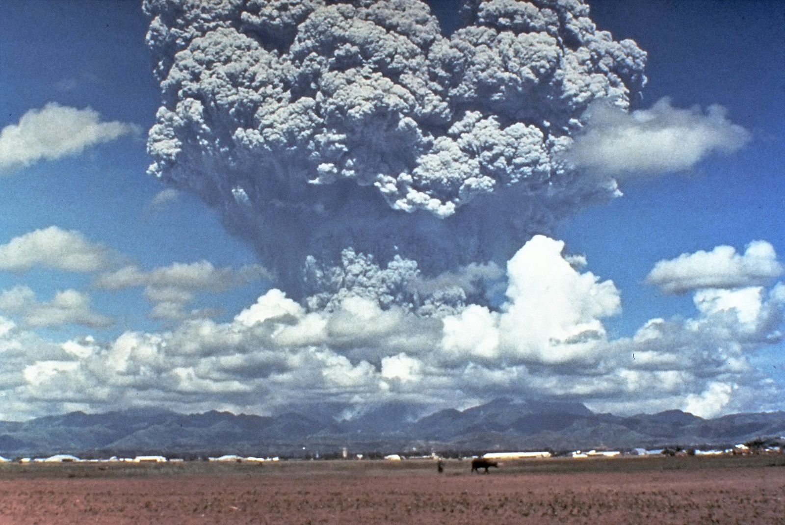
The most recent VEI 6 eruption, this eruption was one of the most important in the history of volcanology. It was the first VEI 6 and volcanic winter to be analyzed with modern technology, and this event greatly broadened our understanding of large volcanic eruptions. The response to this eruption was a triumph, as the preparations prevented 1000s of deaths. Still, this volcano killed more than 800 people due to falling ash. This eruption did substantial damage to the Philippine economy and it produced lahars for years but consequences for the country were nowhere near as bad as it could have been. As such his volcano ranks a bit lower on the scale. Short and Medium range impacts were severe, long range and impacts were moderate, distal impacts were minor. So Pinatubo would be a VSI 5.5
The April 1815 eruption of Tambora

This eruption was one of the largest and deadliest of the past 4.000 years, killing more than 75,000 people directly and causing global famine. All life surrounding the volcano was destroyed by the massive pyroclastic flows. Despite being 10s of km away from the coast, the pyroclastic flows still displaced enough water to cause a moderate sized tsunami that would kill over 7,000 people, the ashfall was so severe that it plunged several major islands into famine and the extensive rafts of pumice would hinder sea travel for years.
The short and medium range impacts were catastrophic, with severe consequences for Long and Distal ranges so this eruption would be a VSI 10
There are several big candidates for VSI 12 eruption, some you already know about but there are some that don’t get talked about but that’s an article for another day and in fact I would like that series to be a joint venture.
With this scale we can have a better gauge of the societal effects of major eruptions but it’s not perfect. If you have any suggestions on how to make the scale better, I would like to hear them in the comment section. No scale can be perfect, since the scale makers aren’t perfect. Perfection should be sought after but never expected.
Tallis


Great article Tallis! An excellent way to gage the human costs of eruptions what would you rank a Mt Pelee or Vesuvius?
I am thinking VSI 4 or 5 for the both of them
I guess our wee pet in Iceland would be less than 1.
Super article.
VSI 0, as mentioned in the article.
VSI is a great idea. But should the VSI include the impact of risk mitigation, should it be potential damage before any risk mitigation or should each volcano have two ratings – without mitigation and with mitigation? Downgrading Pinatubo because of the great work done by local volcanologists, USGS and the local authorities (sorry if I have missed anyone out) assumes that the same level of mitigation would be in place next time – for some volcanoes that might be a dangerous assumption.
That’s reasonable, I would prefer the later the option of two different scenarios, one with prep and one without.
RE: “But should the VSI include the impact of risk mitigation…”\
Well wrought, Tallis. IMHO the K.I.S.S. factor should prevail in the design and utilization of this scale. [Keep it simple…..]. The effect of risk mitigation will be described and explained in comparative analysis as you did with Pinatubo. Each event would have to stand on its own merits. E.g…if the powers that be in and around Naples are asleep at the wheel next time, then the index number will reflect that.
Would you consider multiplication instead of addition for your index? It is the way to measure risk to begin with + the damage of truly bad eruptions is exponentially worse.
The problem with that is that any zero will make the final number zero. Krakatau ends up zero.
Of course. Would have to start the values at 1 instead as 1 is to multiplication what 0 is to addition.
That is probably not possible for some parts of index.
Mitigating factors would have a coefficient less than 1 but greater than 0, so that works.
i’m glad i was here to see the Begining of the VSI scale…. will be fun to say…”yes, i remember it like it was yesterday… there was this Tallis Rockwell……… 😉
I look forward to being the subject of that conversation!
Thanks Tallis! Hope the VSI becomes standard practice!
There seems to be plenty of “rumble in the jungle” underneath Ragnar (or whatever it is called now, Erik? Steinar?). Even a tornillo or two and a few bumps. this morning
But the tremor remains stubbornly disinterested.
I continue to believe the conduit collapsed around 5km down; there have been minor quakes in the area at that depth the last few days. That’s my theory and I’m sticking to it! 🙂
I wonder what will come of this? A new conduit? A conduit by-pass with services and rest rooms? A high-pressure throat clearing blow-out?
Or will the intrusion decide enough is enough for now?
Something to keep an eye on: rapid uplift west of the Askja caldera lake that was formed after the 1875-76 eruption.
https://twitter.com/GeirssonHalldor/status/1435205712590905351/photo/1
https://twitter.com/subglacial/status/1435198530071707650
Something is happening at Fagra. The tremor has spiked and the seismograph has gone wild. Of course it may just be a restless sleep.
Something is a nice way to put it. Harmonic Tremor Readings – Fagradalsfjall is off the charts.
Smoke is increasing as well
I am wondering whether they are working on the seismograph!
I rolled the video back to around 1500 and saw the video vibrating too. Is the seismograph colocated with the close-up camera?
That would certainly make sense, and it also makes sense that maintenance happens during good weather and a calm volcano!
The quake table for Reykjanes is also the busiest I’ve seen it for some time.
Great article and food for thought, Tallis!
If I may, I would question the elimination of climate effects from the VSI scale, since you do include tsunami and pyroclastic flows.
Whether a volcano’s effluent (or power released) flows as a solid/liquid over short distances near the ground vs. dust/ash and gas over longer distances high in the atmosphere is somewhat a matter of semantics since all can (and have) resulted in human impacts.
As you mention, the impact to climate comes in large part from the power of the eruption propelling ash and aerosols into the stratosphere…so I think that this “eruptive power” which directly translates to adverse human impacts should be included in your algorithm.
For example (and highly hypothetical), let’s say a vent with a small scoria cone opens up in downtown Los Angeles and releases a huge volume of CO2 that kills 10,000’s of people trapped in low lying areas.
Would this be considered a high VSI event even though the progenitor “eruption” might have been piddling?
If so, then doesn’t “death toll” pretty much represent what VSI is also measuring?
Regardless, really looking forward to future suggestions of other high VSI events in the past.
Since climatic effects are excluded, should the VSI be considered a “Local and Regional” indicator?
A volcanoes climatic consequences are too unpredictable to be added into this scale for potential scenarios but it could be added in for historical events. The samalas eruption produced an inferior climate anomaly then the 536 eruption despite being much larger. Even now we can’t accurately predict the cooling from eruptions.
For your example, it would depend on where those people died but judging by your description that eruption wouldn’t rank higher than VSI 5. A high death toll won’t ensure a high ranking due to the nature of the scale
Thanks Tallis for the additional clarification. Much appreciated.
I can see your point that other antecedent factors such as weather patterns can artificially enhance (or degrade) the climatic impacts on humanity from any particular eruption.
I have often thought about some type of scale that revolved strictly around human impact…but admittedly there’s too much subjectivity in determining what is volcanic impact vs. second order after-effects.
Confused. Why wouldn’t a high death toll be significant to the VSI? The VSI measures the societal impact?
Let’s say that there is around 100,000 people living 5 km away a volcano that erupts and kills everything in 10 km radius. The eruption would have a high death toll but it’s range is too limited rank really high on the scale
Whats the chance that Saõ Miguel erupts in my lifetime?
Not high, area seems to be episodic and we arent in one of those episodes. Come to think of it all of the Azores was pretty active around 500 years ago but not much since, there must be a cycle but the intervals I dont know, probably we are not about to change though.
As you said before though the eruptions here are dangerous, either silicic eruptions of VEI 4-5 or fluid basalt that can probably flow very fast down the steep slopes, I know one eruption did have both. So not a tourist volcano, better they stay asleep I think.
There are cities too inside the calderas like Furnas and Sete Ciades
A peleean boilover PDC woud kill everyone there as the PDC hugs the ground
Both these volcanoes have shallow evolved chambers of stale Trachyte at around 880 C
There are 3 major trachyte volcanic centers on Saõ Miguel Island
None of the volcanoes are open conduit
Some Azorian mafic lavas are almost Basanite and can reach 1140 C so they are very fluid for soure
In 1563 Água de Pau did a powerful Trachyte pheratoplinian blast that showered the Island in beige evolved pumice.
After that eruption a mafic Basanite lava erupted on the Northen flank and the black red molten mass quickly flowed down and completely buried the old village of Ribeira Seca under many meters of a very fast lava flow.
It flowed like a raging river in spring flood
The lava flow have long since dissapeared under vegitation.
Ponta Del Gada city sits also on a volcanic monogenetic field between Augua De Pau and Sete Cidades volcanoes. Picos Fissural System coud be troublesome for the city If a cinder cone formed in the streets.
But the magma supply to Sao Miguel is so low .. miniscule
https://www.swisseduc.ch/stromboli/perm/acores/g08-en.html
It’s Ponta Delgada and Água de Pau…
Augua De Pau, Furnas and Sete Cidades are the major Trachyte Centers on Saõ Miguel Island
They produce Only stale shallow Trachyte and nothing else
Ponta Del Gada city is under the threat of mafic monogenetic eruptions that ascend directly from the mantle..
The Big caldera forming events in Azores are on Tambora scale and Trachyte! Sete Ciades caldera formed 25 000 years ago
And Furnas did a massive pyroclastic blowout 30 000 years ago, that makes Pinatubo look like a dwarf.
Souch massive blowouts are the products of slow sluggish magma accumulation over very long timescales .. Furnas vent dormant for 30 000 years before that pleistocene caldera eruption, says something How slow the magma supply is to build up souch alkaline evolved resovairs
Not sure it was that big, with how we have observed calderas forming I think there is a good chance, actually even a very high chance, that the calderas are cumulative formation over time and probably also related to rifting, that seems to be really a quite essential part of most calderas of large size. It looks sort of like a cluster of calderas that have merged into one bigger depression.
I think the only oceanic island settings you can actually get a magma chamber big enough to do a borderline VEI 7 is Iceland or Hawaii, just for the sheer size, but the magma flux in both those places is way too high to let it sit alone for that long, except maybe at Oraefajokull but that is only hypothetically. VEI 6 I can definitely see at Furnas though.
As a side note, for those speaking Portugese, does Furnas actually mean furnace, or oven? Seems an obvious answer but you never know 🙂
Furnas is not going to do anything soon .. last time was in 1630. I was there in september 2019. Well the around 30 000 years old Furnas event coud have been a borderline VEI7. And a sizable VEI 6 happened 12 000 years ago in the caldera
Since then its been many smaller VEI 4 s Trachyte events, with 1630 being a large VEI4 that killed 200 persons by PDC s
Azores haves a Oceanic Subtropical Climate its around 16 to 24 C depending on season, making it pretty much best climate on the planet! Often it hovers around 21 C constantly
The Subtropical Miocene Laurel European forests surivived the glaciations by escaping to Azores, Madeira and Canaries.. their last refugee. This biome will dissapear When the Islands erodes away
Woud be fun If it erupts again and goes effusive filling the entire caldera with stale Trachyte dome. Althrough the magma supply for big blocky flows probaly dont exist either there
Azorian Trachyte haves relativly low sillica and are quite mobile .. many domes are pancake domes or thick coulees
It is a cluster of calderas
But the 30 ka outer ring is its own formation
Albert my gmail is visible remove this comment 😂 please
I wrote too fast
I’ve sorted it Jesper 🙂
Very good dragon
Furnas means furnace yes
All over this Subtropical forested caldera is geothermal steam vents
One arera is full of vents
Its spooky with the fumaroles as they steam.
Reminds of the last episode of Walking With Dinosaurs
”Death Of A Dynasty”
As the doomed cgi T Rex walks among the fumaroles at Volcán Llaima where the episode where filmed
Althrough Cruel Sea is my favorite episode in that series filmed in New Caledonia
In Furnas they bake food in the ground easy acess to hot water and steam, sadely the sallad and meat is always overcooked
Would be nice if Walking with Dinosaurs was remade today with how much more we know about dinosaurs, and computer graphics… Probably only the episode set in the Morrison formation still holds up, apart from the notable lack of Torvosaurus and Ceratosaurus it is a very good portrayal of an iconic environment.
Cruel Sea would be better set in the late Cretaceous, Mosasaurus was much bigger than Liopleurodon or any other pliosaur that lived in a shallow sea environment, and it was perhaps also better adapted to risk beaching itself in an attack and actually survive…
The Triassic episode definitely needs some seriously major improvements though, portraying everything that wasnt a dinosaur as being incapable of moving faster then 1 km/hr. Postosuchus could definitely run, so could Placerias, and there were also tiger sized cynodonts around too. Was far from a dinosaurs paradise, that is for sure.
Think the west end of the Alpine Orogeny is in a quiescent period, african plate seems to be sticking here, potentially subduction reversing and development of a microplate. As such I think the subduction has slowed right down, melt is accumulating but slowly, and magma is spreading into the rifts. I predict the pattern will stay the same, long periods between eruptions, but when they come they come in a massive blowout of evolved magma. Sete Cidades is significant.
I think the Canaries also act in the same way.
Azores are leaky transform faults and slow spreading
Combined with somekind of weak hotspot
The Hotspot is so weak its unable to form a subarial lip plateau like Iceland thats astronomicaly more productive than Azores
Great visibility today. Mila’s Reykjanes cam zoomed in on the crater. A helicopter is circling. Are they waiting? Are they (like us) fooled by the nervous tremor?
https://www.livefromiceland.is/webcams/reykjanes/
Is Fagradalsfjall (faf) tremor meter malfunctioning? The stations around it are quiet.
I think someone kicked it, trying to get Nar to wake up
That’s what I’d do if I was there 🙂 Just to mess with everyone on Volcanocafe.
If someone kicked it, they would have to continue kicking it as it has increased over time…
The FAF tremor plot looks like the readout from an implanted defibrillator having detected a heart failure.
https://maps.acme.to/gos/index.php#tremors-1
Here’s hoping whatever that shock was reestablishes a regular pulse.
Volcanic heart surgery.. the seismograph has gone calm, but because the auto scaling is messed up by the surgical hammering, it will be a while before we know how quiet is quiet. By the way, the event is better seen at the low frequency plot
A bypass 😉
Also known as a new vent? 🙂
Tremor on FAF just took a sharp rise.
Whatever that was, it was almost certainly local at the seismograph, and had nothing to do with the volcano… It is still fast asleep, with a very low tremor baseline.
Apparently the spikes we’ve been seeing on the charts are do to maintenance.
At least thats what the comments on the youtube stream are saying. :p
Would they do maintenance to other seismographs at the exact same time? The reason I ask is that I see similar spikes in that same timeframe at latur (lat) and (sgi) on this page;
http://hraun.vedur.is/ja/oroi/allarsort.html
I don’t know where either of those stations are, but they must be close to faf due to showing signals from eruptive episodes.
Could be just wishful thinking on my part though.
Speculations of technical maintenance are emerging on Facebook groups.
Elsewhere, cardiac palpitations are being reported worldwide…
Meanwhile… How is Hawaii doing? Is it still jiggling a bit?
Yes, not like before but Kilauea is still primed to erupt. The recent swarm maybe put off the next eruption by a few weeks at most, still very likely by the end of the year.
From what i can tell there was no deflation associated with the recent intrusion, the contraction on the GPS is from the intrusion pushing the stations together from the south and not the caldera subsiding between them, or the tiltmeter at HVO would show a big drop. Basically nothing has changed except now both rifts are active.
I gather the sledgehammer used to work on the Fagradals seismic station is now broken, and Lars Bashingsmashadottir has been fired.
Unfortunately, the volcano did not respond to the encouragement.
(Unless this was all down to the muppets on the hill?)
We wait. patiently.
Is the magma flow off or has the hose split somewhere and now the hot, fluid magma is mixing with some ancient crystal mush?
Is it possible that the eruption would be becoming… erm… less hiking-tourist-friendly?
https://www.sciencedirect.com/science/article/abs/pii/S0377027300002997
The eruption may become more explosive. But it is very unlikely to be as bad as those in the paper. The previous eruption here has been so long ago that there is no old, partially liquid magma left, and that is needed for a rhyolite explosion. Also, the largest explosions in Reykjanes involve sea water and occur near the coast. But yes, tourists should also be careful. Unexpected events should be expected.
White Island is at it again, did they cancel tourist trips indefinitely?
It’s not the most dangerous volcano around but quite capable of a phreatomagmatic blast, or even a collapse
Furnas is one of Europes most dangerous volcanoes
Furnas in Azores is an potentialy extremely dangerous volcano. It Maybe a sleepy and tired and very stale volcanic system, 1440 persons stil live in this caldera, thousands of persons visit every week. Furnas is capable of infrequent large VEI 5 s plinians and much larger. It generaly produces gassy stale trachyte magmas. But Furnas is indeed a very stale magma system with very low productivty.
With a small magma supply, it means that eruptions are very rarely infrequent and large amounts of magma can accumulate over many thousands of years. The Pleistocene pyroclastic events there where quite big indeed.
So big old stale magma reservoirs are able to form under the calderas. So the eruptions can sometimes be really big plinian and other types of pyroclastic events.
The year small VEI 5 1630 Subplinian killed over 200 persons. The entire arera was showered by trachyte pumice and pyroclastic currents spreading in the valleys. Furnas eruptions are very rare, but if something happens, it will be dangerous. ”Invisible” volcanoes like these are often the most hazardus. Saõ Miguel is not very productive in volcanic materials, its on a superslow transform fault spreading, and partial melting is small. But the volcanoes gets full of gassy old stale magmas, and haves huge explosive eruptions sometimes. Both Furnas, Sete Cidades and Auga De Pau volcanoes are dangerous.
Strange having cities in the calderas
A peleean boilover PDC woud kill everyone in the caldera ..souch pyroclastic density currents hugs the ground like mud convective torrents spreading over the seafloor
But the chance of eruptions in Furnas is very low on a human lifespann
Seen Naples?
RE: “Seen Naples?”
Did come to my mind just the other day,
Infrequent means there should be plenty of rock-breaking quakes before the next eruption. So, a seismograph in the area should give early enough warning for an evacuation. Is there one?
Will be a hell of an swarm before an eruption there
But Furnas does have a shallow Sillica rich chamber of Trachyte thats partialy feed by injektions of alkaline basalt dykes
Furnas is very much like a. ”little yellowstone” haves many of the same features
Just alot warmer in climate and the larger pleistocene Trachyte eruptions never go beyond a very large VEI 6
Saõ Miguel is a stale Island for soure .. magma supply is tired
Lots of monitoring in Furnas
I doubt it will erupt in our lifetime
Its a very stale caldera on a low supply Island
Naples ( Campi Flegeri and Vesuvious)
Are the worlds most hazardus volcanoes
Althrough Furnas is pretty bad too
Most persons in Furnas perhaps dont haves in mind lts an active volcano
Furnas is a subtropical valley for them
Anyway Saõ Miguel is really stale Volcanism ..alkaline basalt and
sillic Trachyte ( an alkaline version of andesite and dacite)
Very little magma supply
Would argue Managua is in a worse situation than Naples. Campi Flegri and Vesuvius are infamous, while at Managua it is bordered by Apoyeqye, which has not even erupted since the city was founded, and Masaya, which has apocalyptic caldera formations but otherwise is a nice tourism volcano, which is exactly what everyone thinks of it…
Would add Quito too. Mojanda and Cayambe are massive, too massive. Cayambe is incredibly unstable. Puluhalua hosts a 5×7 caldera while Chacana is highly rhyolitic and sits in a 24×32 caldera. At least 2 million live in the urban area.
Really theres a lot of places now that are just as dangerous as Vesuvius, just that one is quite a long standing example, and also one for which there really should be no excuse at all given the history behind the area.
I guess it is just a matter of time. maybe that NDVP series could be rewritten a bit today with the knowledge we have now, I think theres a few that probably are not on that list that should be, and also a few examples that definitely are not million death risks.
There’s life in the old girl yet. I’ve spotted a couple of what I imagine are little red spots around the crater rim in the last while when the fog lightens. Hopefully we’re in for a night of fireworks or else it’s only the dwarves with their lanterns checking for newly minted gems.
It’s just the hot lava underneath the crust. It shows through in spots when it gets dark. It was doing this last night and nothing happened.
While we’re back on Iceland, here is an overlay of the earthquakes from 31st July to 7th September around Askja, using a screenshot of the IMO Skaftlisa tool, overlaid onto the deformation image IMO released. The alignment isn’t perfect, but it is the best I can manage manually, as I think the satellite image may be a little skewed from the angle it was taken.
If there is uplift under the lake, would satellites detect it?
Uplift of 5cm since August according to the experts:
https://www.vedur.is/um-vi/frettir/land-ris-vid-oskju
I think the IMO news article mentioned that the inflation would continue under the lake, but wouldn’t be detectable by satellites.
So there could be more uplift under the lake? closer to the earthquakes?
Is there a GPS station nearer the earthquake epicentres?
Water (fluids in general) has the tendency of leveling things out….
I am concerned about this happening in regard to the lake at Askja – https://www.usgs.gov/center-news/hydrothermal-explosions-hidden-beneath-yellowstone-lake-s-serene-waters?qt-news_science_products=3#qt-news_science_products
I dont really think theres a lot to fear from Askja, its about as far away from everything as possible. There was a major landslide and tsunami in Oskjuvatn in 2014 and that didnt do any damage, I cant imagine an eruption being more dangerous than that.
Will be another nice photogenic effusive eruption. Probably a lot more powerful than Fagradalsfjall though, Askja is basically Grimsvotn without ice, same magma and similar size, there is also some rhyolite so it is probably a bit more mature.
Could go full on ash eruption like in 1875, not saying it will, but it has the potential.
Actually I would disagree, it did that in 1875, which was only about 150 years ago. It also did it in the early Holocene, but rifts like this seem to be very infrequent. I think that these two cases are also the only times it has erupted anything other than basalt.
Will probably be like 1961, which is good, very photogenic and safe. Looking at the western edge of the caldera some of these ring fault eruptions must have been very powerful, massive fountains. At least 4 times in the last 600 years, last was apparently unwitnessed in 1873 because tephra from Grimsvotn eruption of that year was mixed in. Probably that eruption was related to the eruptions of years to come, an early sign of instability perhaps.
Grimsvøtn haves much much more constant supply than Askja
Althrough the direct supply to the caldera is not enormous
But the deep resovairs under Grimsvötn are probaly massive for soure
The shallow supply is high enough to prevent it going stale and sillic
Chad Whats the worst scenario for a caldera eruption at Grimsvötn?
😂
Any thougths
The worst would be if it decides not to erupt. We have been waiting for years – it would be terrible
Next eruption wont be very large albert
It already had a massive show in 2011
Probably nothing a lot bigger than 2011 under normal condtions. Bigger eruptions probably happen during rifting, that is probably what also happened in the Saksunarvatn eruptions too. But in terms of big I mean very powerful, not extreme volume, I doubt Grimsvotn has had an eruption directly that is bigger than VEI 5 in volume.
This is of course very in line with other caldera collapses at basaltic volcanoes. Kilauea in 1790 was a VEI 3-4 in volume but a large 5 in power. Masaya did a VEI 7 sized explosion, but VEI of new magma was only a 4. Taal in 1911 is not even a VEI it is basically just not there, but had the force of a VEI 5.
Thanks for that.
Something that’s puzzling me is that the earthquakes – including a couple of deep ones in the last few days – are at some distance from the area that’s been lifted up (ca. 4-6 kms). I haven’t been tracking them in detail but my impression is that over the last few years, the great proportion of earthquakes have been on the E side of Öskjuvatn. Anyone?
I guess it’s a sill, just like the one we saw at Kilauea recently. The area above the sill shows uplift, but the maximum stress is at the edges of the sill, so that’s where most earthquakes happen. You can compare with a dike intrusion, where earthquakes happen at the tip of the dike. A sill is similar, only that it’s lying flat on the side so the intrusion is horizontal instead of vertical. The edge of a sill behaves a bit like the tip of a dike.
Thanks for the helpful explanation. I had been wondering whether it might be a sill.
Being where it is I think it must be pretty deep. It is centered on the older caldera, not Oskjuvatn. I guess to compare with Kilauea the 1870s eruptions must have drained a more shallow pocket of magma, but the larger chamber is intact. It might not be a new sill then.
I guess maybe then Oskjuvatn is like Halemaumau. Probably before 1875 it was some sort if vent structure, a lava shield pethaps, though it must have been pretty old to have evolved rhyolite, at least several centuries. Probably as activity gets shallower it will center under the lake, which could complicate detection.
7.0 M – Acapulco, Mexico
https://earthquake.usgs.gov/earthquakes/eventpage/us7000f93v/executive
https://www.bbc.co.uk/news/world-latin-america-58484951
I was pottering about the Fagradalsfjall page, as one does, and I think the ‘drumplot’ chart has been switched to a higher setting that does not show the background tremor (please excuse my tecchie explanations).
The nearby Grindavik charts show more of what is going on.
Why would they do that?
The scaling is automatic, so this is a response to the strong signals that appeared yesterday (caused by human activity at the site). It will scale back down as soon as those signals disappear from the plot.
Ah – thanks! I didn’t know that. Even after following VC for ages, my thickness knows no bounds.
Cheers!
And I can see the chart is now back to normal, too. Plenty of subterranean activity from “Ragnar” – enough to make me wonder if the blockage can resist.
Don’t worry. After all this time, my knowledge knows no beginning. I am learning every day
From Mexico, signs of another new volcano getting ready to be born… Scientists from the National Autonomous University of Mexico (UNAM) warned that the intermittent seismic activity registered in the state of Michoacán could be related to the birth of a new volcano.
Here is the link… https://mexicodailypost.com/2021/06/10/a-new-volcano-could-be-born-in-michoacan/
RE:”From Mexico, signs of another new volcano ready to be born…”
I have a second home in Puerto Vallarta. Unfortunately, the activities of the cartels in Michoacan and surrounding areas have tempered my enthusiasm for exploring the volcanic fields to my north in Jalisco and south to Michoacan and Colima.
Bummer. But, just remember…
ANY new volcano, will bring a lot of people over there, cartels be *amned.
A Volcano is bigger than all of them!
I noticed on the FAF plot that when it’s not active, there are short-term cycles, approx. twice per day, in the signal. Do these represent daily tidal influences affecting the plots?
Some of this is due to the overflying helicopters, in the morning and afternoon/evening but not at lunch time.
Has the IMO mentioned anything about the lack of activity?
Well, what should they mention? That there is a lack of activity? 🙂
I suppose the only additional info not already available could be if there are some fresh radar satellite interferograms which could potentially give a clue.
There’s a report on RUV today, with comment by an IMO person:
https://www.ruv.is/frett/2021/09/08/otimabaert-ad-lysa-yfir-goslokum
Giggletrans:
‘It is premature to announce the end of the eruption in Geldingadalur, although there has been a break since Thursday. Gas is still flowing from the crater and magma seems to simmer and seep into it in the night darkness.
This is the longest continuous break in the eruption since it began on March 19, but this summer there was a five-day break. Bryndís Ýr Gísladóttir, a nature conservation specialist at the Icelandic Meteorological Office, says that the eruption valves [“goslokum”] are only declared after careful consideration.
“Scientists and the Civil Defense will all discuss this most likely at some point, as this will be taken together with other scientists,” says Bryndís.
Although calm in the crater, embers have been seen after dark. “Also, gas is still flowing out of the crater, which indicates that there is still magma there,” says Bryndís and says that the amount of gas flowing out of the crater seems similar to before. ‘
The scientists on here will know what the implications are of the last statement, but my inference is that Ragnar may well just be toying with us. And on a linguistic note, the key word is “goslokum” which is translated as “eruption valves”. “Lokum” has several meanings but Giggle has, I think, the wrong one: here it has to do with the end of something. Hence “the ending of eruptions is only declared after careful consideration”, perhaps. Perhaps an Icelandic speaker could confirm.
Thank you for this.
Question to anyone who may recall; was the 5-day hiatus mentioned real, and if so, did that hiatus marks the changeover from eruptions ever few minutes to the roughly once a day cycle we were seeing recently?
Don’t think so.
Mid july there was a gap of 4 days (if that is the gap referred to).
Before and after there were (about) one day cycles.
The change from minutes to days wasn’t very abrupt. It changed from minutes to days and back some times.
Thanks, Rob. I wasn’t paying attention at the time (life happened) so I had no idea, and hadn’t been able to find the answer by searching.
I’m seeing a pretty steady decline on the FAF. I’m expecting an uptick shorty, because I believe in Albert’s theory that they are cyclic and due to helicopters. However, the overall trend seems down.
I also suspect that the “helicopter upticks” will decline as well.
If they are talking about what happened in July, the volcano stopped from the 6th to the 10th and then erupted without a break until the15th. I think the cycles were happening both before and after that.
https://www.bing.com/videos/search?q=drfox2000+day+171&docid=13843375916965&mid=C9EE2467DA0BA0AAB722C9EE2467DA0BA0AAB722&view=detail&FORM=VIRE
I hope this video link works. 45 minutes in they show the tremor graphs from that period
Looking at those tremor graphs, you can see that between July 10 and July 15 it went back to doing short cycles with overflows on a roughly 15-minute schedule. Then there was a brief period where longer breaks were mixed with the short cycles, before going to long cycles only.
It will be interesting to see what happens if activity returns.
You can see very faint pulsing on the tremor charts. There is still activity, but it is in a stable state, where the degassing is fast enough to not let gas build up below the cone. Note that the high frequency tremor has been a bit above where it was during the quiet phases between the eruptions, perhaps because of the degassing (I guess). It may return to life very suddenly if something destabilizes the conduit or volatiles do build up past a critical point. But that is not a certain event: it is an ‘if’, not a ‘when’.
Albert, I am not quite sure what you are referring to with the pulsing? Also – the high frequency tremor intensity in the faf plot to my eye looks to be significantly lower than in previous quite episodes. (No counting the effect of bad weather of course)
No idea what this means of course, it might come back tomorrow, it might never come back.
If it comes back though in a single epsiode outputting four episodes’ worth of volume into Geldingadalir, that would make for a truly spectacular lava lake up there. And probably some overflow into Natthagi.
Here is an example. It has a similar pattern to the original pulsing, but it is of course much weaker and only visible when the background goes low.
The tremor has decreased over the past hours, and is now at levels similar to those on the quiet periods/
How to translate this degree of local nuisance:
The damage of ash falls on a developed electricity network in a country that is very dependent on it, health, economy, currency, mobility (I think of Japan) and those in a country that is less dependent on it because less old people to assist, rather agrarian economy of survival, pays in cash and rides motorbikes (Indonesia)?
The inconvenience is the same for people’s lives, just that the inconvenience is different.
Translated with http://www.DeepL.com/Translator (free version)
Started Sept 5th apparently:
“Another glacial outburst flood begins at the Vatnajökull ice cap, Iceland”
https://watchers.news/2021/09/06/glacier-outburst-flood-in-skaft-river-civil-protection-s-alert-phase-in-force-more/
The graph shows the measurements of the Sveinstind station.
Flow and waterlevel are decreasing again. Interesting is also the riverwater conductivity (positive ions in water – micro Siemens) which is dropping fast during the second jökulhlaup passing.
From http://vmkerfi.vedur.is/vatn/index.html
Also Vonarskard picked up the watermass.
Credits IMO.
There is some tremor at Kilauea, localised to the south caldera.
I think we are going to be in for a treat when lava returns to fagradalshraun. The gas emissions are still very high, suggesting lava is not far underground, it is not like at Kilauea or Ambrym where it went to very low levels after their collapses, the conduit is still open. I guess there must be some place magma is accumulating underground building a magma chamber, perhaps there is inflation that is going unrecognised.
What is next is possibly much more separated episodes, and the eruption entering a much more voluminous stage, with tall fountains again and much longer lava flows. Pu’u O’o went weeks back in the 80s where there was not even lava at all in its crater inbetween fountains. 60 days I believe at one point in 1985, as well as early in the eruption when the main vent switched to Pu’u O’o.
I take it that you know the conduit is open by all the smoke venting out of the big fella.
Alert level at Askja has gone up to Yellow, the inflation is now 7cm in the period July 27 to September 9. So far only Icelandic report https://www.vedur.is/um-vi/frettir/ovissustigi-lyst-yfir-vegna-landriss-i-oskju
The latest InSAR image also indicates more clearly that the inflation seems to continue under the lake, as you can see the clearer outline along the north and particularly the south banks.
If the uplift is uneven, will the lake shoreline show evidence of shifting? Has it done so in the past?
Not if we talk about a couple of centimeters. That is too little to make any difference to the shore location
The Iake shoreline can fall soon, if it will vaporizing … Magma is only 3km below it.
3 km of rock insulates pretty well…
But magma can find a way up, when is growing pressure.
Bit of throat clearing at Geldingadalir at about 17:13 (either available close-up cam). Or might be another inner wall collapse. Or a new Vulca-Pope has been elected. Who knows.
Well spotted! I’d guess that was a collapse in the crater. It looked dusty and there was no ejecta.
Or Carl elected VC Pope… 🙂
Drone video from today, a look down the vent
Say whatever you want all you cold hearted scientists: This small dark whole down there is scary. Who’s living there? (Hades)
Probaly glows orange in the night too that hole
The lava is so fluid it just drained away …fluid enough to drain in that hole quickly
But it was an open pipe shaft during the eruptions thats collapses during pauses
This been a very unusual eruption with No other historical equalent in Hawaii or Iceland as startup
It started tiny .. and grew into Mauna Ulu sized fountains. And lava That was very very hot indeed and rich in titanium
Now they are worried that the magma will breakout in other places
But Geldingadalir is Probaly just resting
Awesome video! Curiosity may kill cats, but the urge as a person to walk up to that conduit hole and peer in is strong! It’s amazing to think of the volume of lava and gas that has roared out of that hole. The rest of the edifice looks really dodgy, with cracks and overhangs. Even had some stones tumbling down during the filming.
Wow! Thanks for spotting that!
You’re welcome! I found it interesting that virtually all the outgassing we see is coming out of the walls, there is virtually nothing from the bottom. Might well be a sign that the lava has retreated a long way….possible end of eruption ?
That seems to be a common effect at every volcano, gas vents out of the edges and out of sharp peaks not out the actual vent unless it is actively exposing lava or erupting. Maybe for whatever reason the gas will try to stay underground as long as it can.
(I meant “hole”, not “whole”. The one at ~3:20, with the wooden door.)
Great, Tallis. You know the problem with this, however. You mention the brilliant preparation for the Pinatubo eruption in 1991, and obviously there was no preparation whatsoever for Tambora in 1815. The problem is time and knowledge. The Romans were completely unprepared. Today there would hopefully be ecacuation. St. Helens had next to no fatalities concerning deaths, but landscape and properties looked awful. So Tambora today would most certainly produce less fatalities.
You asked for suggestions to make the scale better. I suggest devastation of land, crops and houses to compare. But only with pics, so visible devastation, as monetary comparisons have the same problem with changing times.
Best regards
Addition: The Jesper thread further up gives me an additional thought: There is a difference in loss between Furnas and Campi Flegrei. So any scale like this one should have a reference to the number of population.
Damage to agriculture and property would be factored into the impact but using photographs to help rank certain eruptions seems a bit redundant in my opinion.
English version of the Askja news https://en.vedur.is/about-imo/news/headline-for-askja-item
I wonder if they are restricting access to Askja and the lakes. Back in 2010 my wife and I hiked to the little lake from a tour bus; it was a popular attraction then and probably still is.
I don’t imagine that access will be restricted just yet: the weather will be rendering the roads largely impassable in a few weeks, and the yellow alert level itself is a warning. Also, iirc, the authorities were unusually restrictive about getting to Holuhraun owing to the amount of SO2: compare access to F’fjall. But if an explosive eruption is on the cards, well…
It is not, an acquaintance of ours was there 2 days ago. Mostly worrying about the Hlaub and getting through Eldhraun though 😔😉
The northern hemisphere aviation community should invest in a pipeline/pumping station potent enough to empty that lake on a weeks scale. Could potentially save some trouble 🙂
Is anyone currently writing anything about Askja? If not then dibs 🙂
Been looking at it quite a lot this past few days, making maps etc. I think there is a not small chance it will erupt before I finish though.
We suggest you wait until after the weekend as there is a post in the pipeline.
That is good, I have not written much yet 🙂
Thought I might try to write about it before an eruption actually happens. I had not realised active magma was only a few km deep, more that it was still down in the depths of the volcano and still years off. 3 km is almost at passive degassing depth. Theres perhaps some assumptions to hold on this but we might only be a few weeks off from the first ever undeniable dual Icelandic eruption 🙂
well – Reykjanes remains on hold and may not come back
Yes, one of those assumptions, the other is that Askja will actually erupt because we havent seen it do that with modern tech. In general though now is a better time than most to see dual and actually simultaneous eruptions in Iceland.
Breath in…, bbreath out ….
That’s Askja! 🙂
I’m pretty sure Fagradalsfjall is over for this period.
I’m sticking with my theory the conduit collapsed @5km down on 3 September. Gas is getting through, but there’s not enough ‘ooomph’ in the system to clear the blockage.
If there is a second phase, it may be elsewhere. Or it may be at Fagradalsfjall. In either case we will see a lot of seismic disturbance before anything restarts.
Meanwhile the view over Natthagi valley has a parade of 50+ aged men pulling silly faces at the camera. Sigh.
(I write this post in the hope Fagradalsfjall will prove me wrong in the “famous last words” category.)
I tend to agree with you – but this volcano has a tendency to do its own thing
While we are distracted by another Icelandic volcano showing inflation of 7 cm in a month, Kilauea has inflated by 17 cm in about 2 weeks. The earthquake swarm stopped a while ago now, so no new rock breaking, but magma has continued to flow into the south caldera rapidly. OUTL station right above the August swarm has actually kept going up almost as fast as back then, just not moving in other directions so magma is local. The tilt at HVO has also just this past 2 days begun going up, the cross caldera GPS shows no change but that is both of the relevant stations being pushed the same direction and not towards each other.
Basically all the signals of an imminent eruption, but not in Halemaumau.
The recent interferogram shows no inflation over the recent 6 days, SDH tilt has flattened, very little siesmic activity, OUTL gps movements look like noise, there is no “HVO” tilt station?? Is the eruption imminent because nothing is happening?
https://sarviews-hazards.alaska.edu/Event/80?pinned=8c3ff8cb-cf1d-48e1-a18b-f439fc674a88,50f8c296-fede-4944-b8f4-019393b368c8
This seems correct. There has been little change in the last several days. The overall movement is impressive, though.
I think the map you linked is not resolved enough, showing the whole island. Most INSAR of Kilauea are focussed on it in particular, so I think could be targeted. But my phone wouldn’t load the site properly so I couldn’t check 🙁
OUTL is moving on cm scales, in GPS that is a lot, they are calibrated to an order of magnitude less. It doesn’t show any more movement in to indicate the August intrusion is ongoing but the vertical is still going to the moon. So is CRIM, and AHUP. There is no movement on SDH tiltmeter so the magma must be a bit deeper, tiltmeters arent sensitive to anything over about a mile deep unless it goes really crazy. HVO tiltmeter is on the main deformation page, it is really UWE but that instrument on the map is not available.
Mauna Loa stirred a bit over the past few hours–the usual place NW of the caldera, 4-5 KM depth.
Askja shouldn’t be all that dangerous. Seems to do larger eruptions tens of thousands of years apart, and mostly ring fracture basalt. Great old documentary here from the 1961 eruption, rivers and fountains of fire:
https://www.youtube.com/watch?v=udoCcutHN28
Oraefojokull is more of a danger given the greater repose time and the history of huge silicic explosions, there was a series of earthquakes in 2017 if I recall?
Always learn something new when studying icelandic volcanoes, it’s amazing that such advanced magma can be created in a rift-stretch setting. Hawaii tends to belch everything out before it has time to mature.
Also puts the Altiplano into perspective. If dacitic magma can be generated in a thousand years or less, then it’s no wonder the crystal mushes that have been sitting in massive sills under Uturuncu and co. for a million years that are then overturned by a basaltic injection well and truly explode.
First analysis of Martian rock samples – Volcanic rock and water interaction.
https://mars.nasa.gov/news/9036/nasas-perseverance-rover-collects-puzzle-pieces-of-mars-history/
Some really good images coming in on raw feed from Ingenuity Flight 13.
Sample image.
Do we have any idea of the scale of the features here?
This should help
http://www.unmannedspaceflight.com/index.php?showtopic=8610&view=findpost&p=254424
Forgot to credit the user who posted – Nahúm on Unmanned Spaceflight forum
Also there’s the 3d model at https://www.perseverancerover.spatialstudieslab.org/ with flight paths.
You can also get a sense of scale from the 1 frame per second navcam downloads. Speeded up gif of Flight 13 – helicopter shadow is same size as helicopter – blades 1.2 metre diameter. Note that the colour camera points towards the left in the navcam images.
The gif is too big to embed here but can be seen at link
https://twitter.com/martiandennis/status/1436417894020050946
Furnas translates as ‘caves’
Not a nice volcano … a stale invisible killer caldera. But the chance of eruptions are very low on human timescales .. Furnas is an extraodinary stale system .. alive but stale as heck
It probaly dont even have any frequent supply at all ..
But it remains alive and can produce very large pyroclastic events
Some Pleistocene events there been truely enormous ( VEI 7 ) holocene events been many VEI 4, and one huge 5 .. year 1630 was a borderline VEI 5 Trachyte event
Althrough the melting supply is large enough to avoid Phonolite in Azores
The primary melts are alkaline basalts that are on edge of being Basanite that is the parrent melt of Phonolite
There are No major Phonolitic centers
Expect Erebus.. that is an extraodinary active phonolitic volcano
And the Only higher viscosity lava lake at current
I wonder what the evolved version of Nephelinites are .. But they are produced in souch small ammounts that they cannot support large chambers. Nyiragongo is the Only major nephelinite center for now
And now I find myself staring at the tremor plot and thinking ‘is this it?’ The volcano is playing with us
There is a new signal right now. Perhaps not just a single spike.
I know.
It’s sucked me in anyway.
We just can’t help ourselves.
https://www.youtube.com/watch?v=udoCcutHN28
Video of Askja in 1961. Looks like the lava is very fluid, just like Bardarbunga or Hawaii.
Cheers for that! Great find-the music sounded real creapy esp at the end- was expecting the little green men from Mars to arrive feel..
Yeah, agreed, sound track was excellent.
Splendid to hear English pronounced correctly, too, I say. What.
(And in unironic mode, almost sounds like a foreign language.)
Tremor graph looking a bit more promising:
 is getting noisier at the same time. Could be many hours yet though.
Starting to show similar pattern to previous eruptions.
Duh…
links disappeared:
Hope they show up now.
Maybe not 🙂
An eruption now would be good timing…a new 3D model has just been published
https://sketchfab.com/natturufraedistofnun/models
It’s beginning to look like a bona fide shield. Looks like there has been significant infill ‘behind’ into Geldingadalir.
Dammit both closeup camera URLs are stale. Does anyone have the new ones?
Think they turned them off because of lack of activity. I think both closeup cams were actually up at the same place as the main cams and zoomed in though, the old one on theater hill got buried I think.
I think they will be quickly restarted if eruption resumes though, it is probably just to preserve battery life in this bad weather, or maybe bandwidth.
Try https://www.livefromiceland.is/webcams/keilir-thermal/ It shows hot air rising above the crater
Does anyone have the tremor plot link. I lost it 🙁
Also how long ago since it last updated? I think it is once an hour.
Don’t know how often it is updated. My guess is every 30mins.
Oh, of course (stupid me). Here is the link: ‘hraun.vedur.is/ja/oroi/faf’ (add .gif as suffix).