The Barberton geotrail
People mellow with age. (At least, most of us do.) The emotions of youth become less all-important and less demanding of our attention. Young people feel that every perceived slight needs addressing. The heat goes to the head and mistakes are made. Older people consider more before responding. The Earth, too, went through a youthful phase, before it settled down in middle-age continentality. In its youth, volcanoes were everywhere and the lava they produced was hot. It was a restless time. It took the Earth a billion years to grow out of it.
The young, hot-headed earth was almost entirely a water planet. We are talking 4 billion years ago and the time of the late heavy bombardment had just ended. The first continental slivers were forming. The oldest of these that survives is at Amitsoq, south-east Greenland, a combination of volcanic and sedimentary rock. Plate tectonics was beginning although still in its infancy: full blown plates with their subductions would not exist until another billion years. But mantle plumes existed, probably more plentiful and faster than nowadays. These threw up volcanic plateaus and islands, and these became the cores of the new continents.
The best recorded of the origin stories of the continents comes from the Southern African craton. This was once the heart of Gondwana. But the region was much older than this. The oldest rock here is a staggering 3.6 billion years. It takes us back into a different era, called the Archean, a period lasting until 2.5Gyr ago. The Earth was a different planet. The atmosphere was not conducive to life, with high CO2, probably mixed with methane to give a photochemical haze in the air. But the ocean already existed. The oceanic crust was divided into numerous microplates, where everything was more active than now. The interior was hotter. There were no continents yet but there were plenty of oceanic islands.
Building a continent
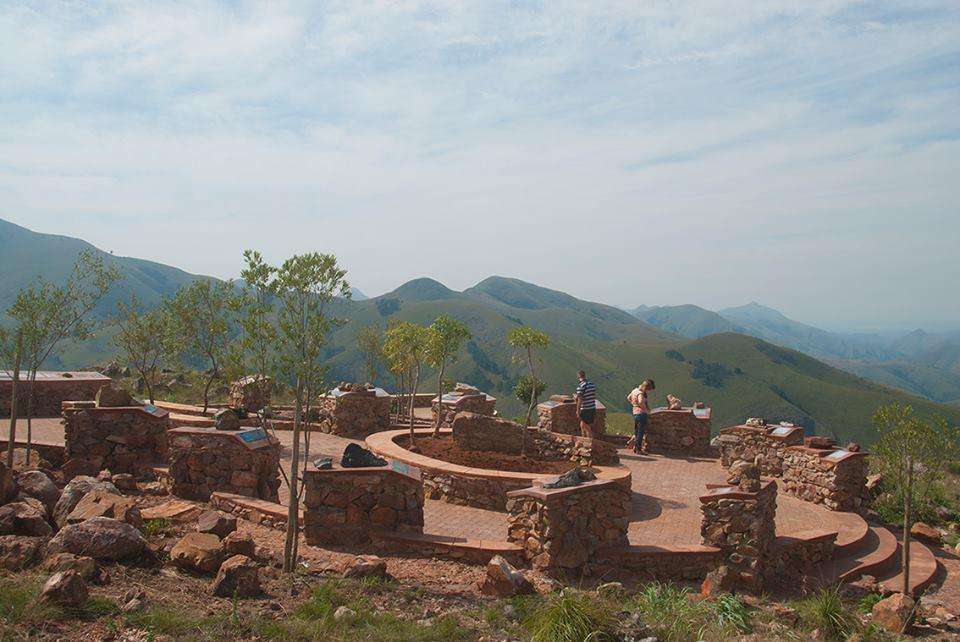
The location of the oldest rocks of the South African craton are in Barberton. They are called the Barberton greenstone and they tell a story about how the continents formed.
The rocks form a belt stretching from northeast to southwest, roughly 100 by 60 km with rocks covering an age range of 500 million years. The region is at the border of Swaziland, just south of the famous Kruger park. The southern parts of the Kruger park are dense with wildlife and tourists. The river is full of hippos and crocodiles and the wooded area hides the elephants well. They have right of way, even if suddenly appearing from the bush, and they know it. They happily chase the drivers to let them know who is boss. The real Kruger is not here: that is much further north where the land gets wilder and the animals more dispersed. But if you want to quickly get your African safari in, the southern Kruger is hard to beat. The birdlife is also superb. Sometimes the animals get out of the park, and you may suddenly find a hippo in your pond. Nothing to do but call the park service and ask whether they do collect.
The Kruger park is rugged, with lots of granite ‘kopjes’ (small peaks). The landscape looks ancient. But it is nothing on the Barberton area where the rock are many times older. Not much has survived, of courses. The originally horizontal layers have turned on edge in timeless upheavals. This is why the belt is narrow. The whole area is embedded in ancient graniodorite which has survived better – partly because it was underground. It is all part of the story.

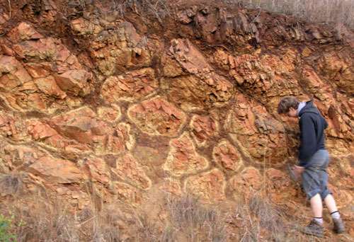
The Barberton mountains are a green land: in the wet season it is covered in bush and some forest. It is an ancient greenstone, but that does not refer to the vegetation. The ‘green’ in the greenstone comes from chlorite, and it makes rock rather unpalatable to vegetation. The chlorite is a later metamorphic addition to the rocks, but it shows its origin as oceanic crust.
The original rock consists of three groups, called Onverwacht, Fig Tree, and Moodies. Onverwacht is the oldest of the three. It is mostly volcanic. The rocks of the Onverwacht group show how volcanic rocks erupted onto an ocean floor. Just like in modern oceans, the water cools the surface of the lava and the pressure prohibits any explosive activity. The result is pillow lavas. Indeed, the Onverwacht group shows plenty of these pillows in the region. There is little doubt how this land began, deep under water.
Pillow lavas in Barberton. Source: http://all-geo.org/highlyallochthonous/2007/07/what-is-a-greenstone-belt/
The most common origin of pillow lavas is a mid-oceanic spreading centre. That has also been suggested for the Barberton rocks. But it has been questioned. The eruptions began 3.54 Gyr ago and lasted for 250 million years. That seems too long for a spreading centre. The layers also are extensive and not faulted. The suggestion is that this was a volcanic plateau or submarine shield volcano. It is not known whether plate tectonics in its modern form, with spreading centres and subduction zones, had already developed on Earth. It may have been an environment more like Venus, with areas of volcanic activity and deeper basins without, but without larger scale motion from one such area to another. The origin of plate tectonics is still debated.
In the modern world, pillow lavas produce basalt. But although the Onverwacht group has a minor basaltic component, the majority were a different, much hotter type of lava. This type was first identified in the Barberton belt, along the southern part where the river Komati flows. It thus was given the name komatiite. They don’t make it any more. Nowadays, oceanic basalt is melted in shallow magma reservoirs at temperatures of at most 1300 C. The komatiite was formed several hundred degrees hotter, up to 1650 C. They came from a mantle that was notably hotter than nowadays.
The eruptions were not continuous: they were interrupted by epochs when thin layers of sediments collected, composed of iron-rich and silica-rich mud and volcanic tuffs. After the pillow lavas stopped forming, the sedimentation kept forming, now including carbonate layers which buried the lavas. The sedimentary layer is called the ‘middle marker’ and is a widespread part of the Onverwacht group. The carbonate shows that the ocean was much like that of today, with abundant calcium carbonates. The most notable is a dacitic layer, 2 km thick, dated at 3.45 Gyr ago. This has been interpreted as the subsiding volcanic peak, in fairly shallow water.

Fine-grained mafic ash, Onverwacht Group showing cross-bedding stratification.
Now a second pile of volcanic rocks formed, but with a composition of basalt and dacite. This is the upper Onverwacht group which formed around 3.42 Gyr ago and there are similarities with modern-day island arcs. The magma did not come from as hot a chamber as the earlier komatiites. The dacite suggests that the magma chambers had time to cool and differentiate. It has been suggested that the newly formed oceanic crust was subjected to some subduction, partly melted, and percolated back into the crust.
Now things quieted down for a while, until the Fig Tree group formed between 3.26 and 3.23 Gyr ago. It is a volcaniclastic sedimentary sequence that is capped by felsic volcanic rocks that formed in deep- to shallow-water to alluvial environments. Some of the deposits show evidence for turbidites: underwater landslides. In these slides, the coarse material (sand) reaches farthest and mud the least: mud therefore forms the upper slope. The mud stones are quite black from the amount of graphite. This suggests that the volcanic islands were bounded by a trench into which the slides went down.
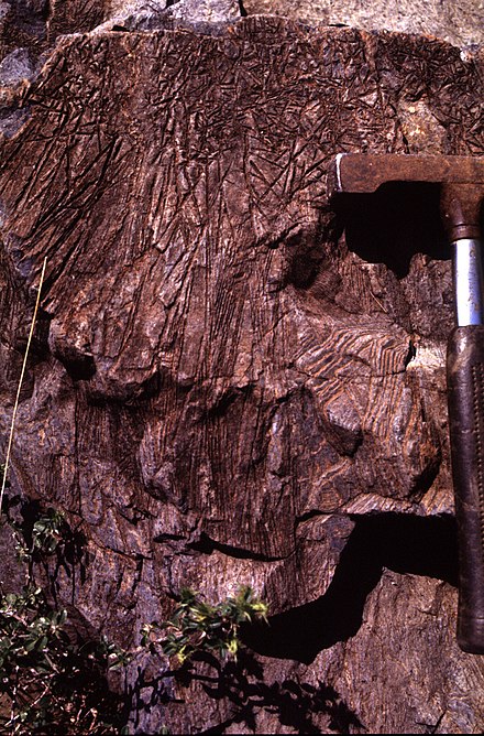
The Moodies Group was deposited next, between 3.23 Gyr, and 3.11 Gyr ago. It consists of shallow-marine to fluvial sandstone and conglomerate with minor shale and banded iron-formation. It shows some banding that is typical of tidal bays, where even the neap-spring tide cycle can be seen. Counting the layers shows that there were only 18 days in a tidal month, a combination of the Earth spinning faster and the Moon being closer than nowadays.

Silicified cross-bedded and wave-rippled sandstone overlain by chert-slab conglomerate; Buck Reef Chert , central Barberton Mountain Land.
What happened? The island arc and trench suggest that plate tectonics was beginning to behave more like the modern Earth. The partial melt had formed a graniodorite (felsic) which had been emplaced in the oceanic crust. This reduced the density of the crust, thickened it, and caused the area to rise. When the oceanic floor began to subduct, this region was too buoyant for that. This lower density material formed the core of the island and morphed it into young continental crust. The lithosphere thickened and formed the 100-km deep keels of the modern continents. The Barberton area was not a single terrane: it was several distinct regions which formed in different places and only came together during the last phase of the Moodie group.
This process went on not just in the Barberton area. Similar events took place elsewhere in the world. The Pilbara area is an example, with the same age as the area here. The next phase came when series of these new island arcs began to amalgamate. This formed the core of the new cratons. The earlier granite was remelted, and now formed large emplacements of over 60 kilometers in size. The process would continue for another 500 million years. By the end, the world was full of microcontinents. The first continental collisions occurred. Mountain building began. 2.5 Gyr ago, the Archaean ended and the modern world took shape.

Microbial laminations interspersed with sandstone and overlying conglomerate of a fluvial-supratidal sandplain, exposed in the Moodies Group of the Saddleback Syncline, central Barberton Greenstone Belt. Angular green clast is composed of altered ultramafic rock. This and previous photos: 35th International geological congress, 2016, Cape Town
Impact
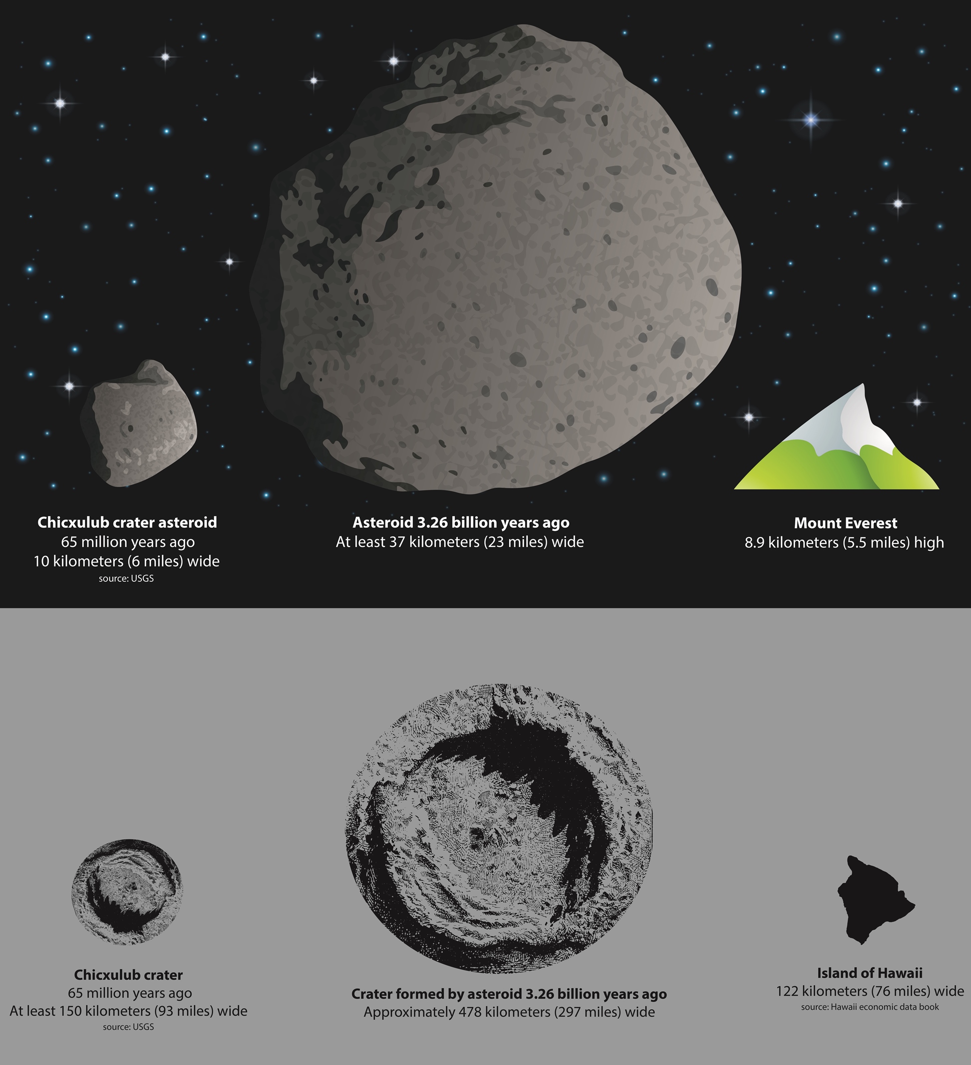
There was another event which left its scars. At 3.26 Gyr ago, the Barberton area shows a layer of spherules. The spherules are the size of sand grains, and formed from condensation of rock vapour in the atmosphere. Effectively, these were liquid rock drops which formed in the atmosphere. It rained rock. There are four such layers in the Barberton greenstone, but this layer (number 2) stands out, at the border between the Onverwacht and Fig Tree groups. The layer has a thickness between 20 cm and 3 meters, of which between 10% and 50% consists of the spherules. It is present in the southern area of Barberton. The same layer is seen in the Pilbara area. It contains chromium indicative of an extraterrestrial origin. This was a meteorite impact, from a carbonaceous chondrite. And not just any impact.

Spherules from layer S2. Source: Lowe et al. ASTROBIOLOGY Volume 3, Number 1, 2003
Based on the thickness of the layer, the impactor has been estimated as between 37 and 55 km in diameter. This is considerably larger than then the KT event. The impact caused dikes to form in the Onverwacht group. Some of the spherules found their way into these dikes, suggesting they were still open when the rock rain arrived. Gradation of the spherules suggests passing tsunami waves. The area was still deep under water, but this did not protect against currents caused by the tsunamis, or the earthquakes. The moment of the earthquakes has been estimated at a minimum of M10.8. A crater of some 500 km across may have formed. However, this would have been on Archean oceanic crust of which little survives, thousands of kilometers away from the Barberton rocks.
Credit: American Geophysical Union
There was a second impact of similar size 30 million years later. These are likely the two largest impacts the Earth has suffered over the past 3.5 billion years ago. Were they related? That seems plausible. Perhaps a large asteroid had broken in two following a collision, and both fragments ended up with orbits with intersected the Earth. A game of russian roulette followed which only had losers.
One more thing is worth pointing out. The S2 layer is exactly at the change-over between the Onverwacht and Fig Tree group. In fact, so is the S3 layer, as the change happened a little later in the north of Barberton where the S3 layer is seen. The Fig Tree group is one of felsic volcanisms, and the onset of internal melt which formed continental crust. Perhaps these impact had a role in this. They formed large cracks where magma chambers could collect, may even have induced melt themselves, and ended the epoch of komatiite. Was this a worldwide change? It probably would have happened over time any way, but these massive impacts may have accelerated the change.
Komatiite
But what is komatiite, and what was different about the Earth to make it form?
Komatiite is an ultramafic magma. ‘Mafic’ stands for a magma that is rich in magnesium and iron. Basalt does this: it is a property of mantle material, and mafic magma thus indicates that there is a conduit to the mantle. The mantle is not normally melted, so heat needs adding. That can be done either in a spreading centre (where mantle material can upwell from deep because of a lack of pressure above), or it can through heat from a hot spot. The hot spot can be shallow (most are) or it can be a proper mantle plume. The lack of silica makes the magma to be of low viscosity: it flows easily, and over long distances. It is also dense, and that makes it harder to erupt over the less dense continental crust without some significant heat input.
Ultramafic is even closer to the composition of the mantle, and has very low silicate content. In the modern world, this happens when magma chambers collect olivine from the mantle and slowly become more and more mafic. The result is picrite basalt, and this can erupt in places like Hawai’i. But in the early Earth, the olivine from the mantle could erupt directly and this is komatiite. It is silicate and aluminium poor and has a very high melting temperature. Its viscosity approaches that of water, so it flowed every more easily than basalt. But there haven’t been any significant komatiite eruptions since 3 billion years. The aluminium is not always the same: some komatiites are depleted in aluminium, but others are not. The undepleted ones are older.
Barberton komatiite. Source: wikipedia
The melting temperature of komatiite depends on its precise composition, and it appears those changed over the archaean. For a MgO fraction of 30% (typical for the early archaean) and chromite content over 1500 ppm, the melting temperature is around 1600C. The melt happens at 400 km depth, at a mantle temperature of 2000 C. This is believed to be appropriate for the Al-rich komatiites of Barberton, and those elsewhere in the world at that time. The mantle was hotter than it is now, due to higher level of radioactives, but not this hot. So where did the komatiites come from? The temperatures of a few hundred degrees above the normal mantle suggests the presence of mantle plumes. The komatiites are believed to have formed in the tails of superplumes. This puts the evidence for the extensive pillow lava under new light. These regions may have been the ancient, subsea equivalents of modern flood basalts.
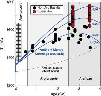
Mantle temperatures
The hotter mantle would have had lower viscosity than the modern mantle, making plumes easier to form and faster to rise. But as the mantle cooled, things changed. The komatiites show lower MgO, less Al and Cr. They would have melted at lower temperatures, 1400C, and lower depth of 150-200 km. By the end of the archaean, 2.5 Gyr ago, conditions for komatiites were only found in few places and the fraction of such lavas decreased dramatically. The youngest komatiites erupted 100 million years ago on Gorgona island. But these are lower MgO, and the melting temperature was much lower than hat of the pure komatiites of the Archaean. They are part of our new, mature world. The hotheaded days of the Earth are well and truly over. All that is left is a memory of greenstone belt. Barberton is the graffiti of our youth.
The South African craton had more to look forward to. It would merge with other cratons, and suffer break-ups. There were massive intrusion and more than one large flood basalt. There would be seas and deserts. Life arrived, and three million years ago hominids arrived. And there was another impact, possible the largest on Earth since the Barberton greenstone. That impact is for another post.
Albert, February 2019

Protea in the late Barberton winter


Really good article – nice
I’ve often wondered whether the Bushveld Complex was actually due to an asteroid. It’s later than the komatiites, at about 2 Gy. The presence of large amounts of exotic elements like iridium, and of course platinum and palladium, suggests an extraterrestrial source, although that doesn’t seem to be the received wisdom. That the whole complex is fairly circular in shape is also suggestive.
This is not without analogy since the Sudbury Basin nickel provinces in Canada most certainly were from an asteroid. Interestingly the shape and size of the Sudbury Basin and its associated nickel mines is similar to the Bushveld Complex mining province. And they’re of reasonably similar age (Sudbury is about 1.85 Gy).
I’ve done a lot with nickel over the years, and most of the time it comes from ultramafic units. Komatiite is responsible for a lot of the Western Australian nickel mines, which I’ve assisted from time to time.
Gorgona, Pacific Ocean, Colombia. Youngest Komatite, from the Cretacious.
It is always the same in Geology. You have some associations, then make a link, assume s.th., and then the guy turns up who destroys everything. In the case he is rightly named after Gorgo.
Anyway, what makes Geology (and Paleontology plus Biology) so interesting is not what we know, but what we do not know. Working with dots all the time.
One of the best programs on this is Aubrey Manning’s Earth Story and the irrepressible Maartin De Wit holding forth on barberton with its pillow lavas and deep sea vents from 3.5 billion years ago.
I can also recommend the book ‘The story of Earth & Life’ by McCarthy and Rubidge, which focusses on South Africa. Very good if you plan to visit the country.
The Onverwacht impact was probably one of few asteroids that created a hole deeper than the crust. An impact like this would cause high temperatures that would vapor rock and metalls. What temperatures can we expect there? Do they get close to nuclear explosions? Can an impact of this size even cause a temporary plasma?
Did plumes/hotspots precede the occurence of plate tectonics? If there were plumes without continental drift, even relatively weak plumes would be able to accumulate big masses of lava. Maybe some hotspots looked like Olympus Mons.
To get a sense for the Ages of the Earth, it’s interesting to look for the basal complexes that once were high mountain chains, but now are the flat crystalline base for continents. Compared to the Alpes, Himalaya or Rockies, for us humans the Caledonian orogency looks very old 400 million years ago. But the Caledonian orogency occured on the edge of Baltica that is the crystalline base of the microcontinent below Baltic Sea. The whole Baltic plate was created from orogency mountains ~2 billion/milliard years ago, that are long gone, but left extremely solid rock behind. The Swedish and Finish rocky skerries reveal this crystalline rock well.
https://www.sciencedirect.com/science/article/pii/S0012821X20302399
Hawaii plume has erupted lava as hot as 1700 C, olivine with a Fo# number of 91.8. One of these near 1700 C olivines was erupted by Mauna Loa only 0.1 million years ago too so its likely still that hot now just not getting to the surface fast enough to avoid cooling. Some of the olivine erupted in 2018 at both Halemaumau and the lower ERZ had Fo# numbers up to 90, indicating temperatures of 1300+ C within the main magma chamber of Kilauea, the one under SDH.
Yet for all of these as well as similarly hot lava at some other locations the lava was still basalt, so there might be more reasons than just temperature for why komatiite isnt erupted now. Maybe billions of years of subduction has affected even the deep mantle and altered the chemistry.
It could be that komatiite actually does exist in Hawaii, but like how rhyolite will float on basalt, basalt might do the same to an ultramafic melt, so it is impossible for it to get to the shallow system and erupt. Some mid ocean ridge sections with no cover might be able to erupt komatiite though, that is likely what the Gorgona rocks were.
https://www.earthmagazine.org/article/young-costa-rican-lavas-might-reflect-pockets-primordial-mantle/
Komatiite has high density. It needs to be very hot before it can rise to the surface. So it may still exist but doesn’t easily erupt
Thats why I mentioned mid ocean ridges, particularly fast spreading ones and possibly the Reykjanes ridge far south of Iceland. Maybe the best chance is in the Lau basin near Tonga, which has erupted boninite that is very similar though with higher SiO2.
Very interesting question. I might be that the balance between calcium and magnesium is slowly changing, since calcium can be deposited as gypsum onto the ocean floor, but magnesium tends to stay in solution in the ocean. A couple billion years later and you’d have a higher Ca:Mg ratio in magmas at about 600 km depth where the slabs dissipate. Then of course there are all those subducted coral reefs rich in CaCO3.
Kilauea E24 visible from Oahu, although this isnt in visible light I presume it is near infrared.
https://www.facebook.com/share/v/12JWJfx9p4f/
Fascinating! Thank you Albert!
“The komatiite was formed several hundred degrees hotter, up to 1650 C. They came from a mantle that was notably hotter than nowadays.”
1650 C, outrageous. Where is Jesper?
Might be an interesting addition:
“A new study has unraveled key findings about the earliest life forms on Earth. In rock samples from Barberton, Republic of South Africa, researchers were able to find evidence of an unprecedented diverse biological carbon cycle established at 3.42 billion years ago. This proves that already at these ancient times, ecosystems hosted complex microbial communities.”
https://phys.org/news/2024-01-ecosystem-billion-years-pieces-cradle.html
There is always a bigger fish:
Note: Hypothesis
Aftermath of Theia merger must have been an impressive sight the kinetic energy of souch a large planetesimal merger is hard to imagine, alot of Theia and local parts of Earths upper mantle was vaporized during the collision, young Earth covered by an incandescent “photosphere atmosphere of rock vapor gas” for quite a while after that impact until that rock gas cooled and condensed and rained out as lava after 2000 years.
The infant moon is tought to have formed rather very quickly in the hot impact debries rock cloud, it woud be an impressive sight shining white hot of its heat …
I think the small lunar fragments would cool quickly given radiative losses into space. The moon would be made from relatively cold fragments colliding at relatively low speed (all being in roughly the same orbit) which explains why the moon has no liquid core now. It probably never had a very large hot one anyway.
However very many volatiles (for some definition of volatiles) would have escaped and perhaps made their way sunwards via venus….
My 10c worth anyway.
Moons small size means its cooled quickly, its a completely differentiated mantle core and crystaline crust body so the moon was nearly 100% completely molten long ago it was ( likey formed from theias condensing rock vapor into a magma ball )
It woud be as if the sun itself have come down to Earth with the extreme surface conditions of Earth weeks after the Theia impact. Imagine the whole planet covered in a cocoon of rock vapor gas, Earths molten surface roasts at perhaps 6000 degrees c and being under a pressure of a few 1000 s of atmospheres of “rock vapor gas” there maybe barely any sharp boundary between Earths molten surface and the vapour weeks after the Theia impact. Viewed from orbit Earth looks like looking into the sun itself I guess shining hot of kinetic energy … high up in the vapor envelope there maybe superhot clouds of magnesium oxides condesing…a total hellworld is a fitting description of the peak of Earths early ackretion
Without this, we probably wouldn’t have life on earth. The – in fact – double planet system of Earth and Moon stabilizes the rotation and movement of the Earth and allows the evolution of life.
That is often claimed but I have not been convinced by the argument. Life evolved in the oceans and therefore was quite mobile. The changes of the rotation axis may not have been a major problem.
We might find out soon enough if this is useful when Europas ocean is explored. Even if the ice is very thick there will be parts that are thinner, maybe even basically at the surface depending on how hot the ocean is. Based on Io, theres a reasonable argument that Europa is also volcanically active, it is a rocky moon too just with an ice layer, and involved with the same tidal pull just not as intense.
If enough H2O2 is present in the ice, then the surface of the ocean is likely oxygenated enough for aerobic life, although maybe not enough for fish to live in.
This is an interesting article. It’s no secret that komatiites are quite fascinating, being so hot it could thermally eroded through rock and quite fluid, as fluid as water. Most of the komatiites has gone by 2.5 billion years, but there are exceptions. The Gorgona komatiites is the more famous and recent of the bunch, having erupted about 85-90 MYA, however it isn’t the only one. There are the komatiites of Mashhad in Iran and Gilmore Island, both post-Archean era in age (Mashhad being about ~280 MY old). There’s a fourth one I would like to focus on – the Tortugal komatiites.

Now, the Tortugals are not new. Maybe a year or two, I have been screaming from the peaks about this one. Why? They’re just interesting and I am going to talk about it, again.
Doing a bit or research, these komatiites (including the Gorgona komatiites) all formed as part of the Caribbean Large Igneous Province (CLIP), a step in the formation of the current Caribbean plate. Now, it seemed to initially formed around 110-140 MYA, perhaps by the Galapagos plume, whereas it experienced a sort of reactivation 70-90 MYA. It’s this second pulse where the infamous komatiites are formed.
The Tortugals in general are formed first, whever be it underwater or above is unknown (at least to my knowledge) before quitting down and erupting the less exciting alkaline basalts or trachybasalts that split the komatiitic rock.
Now, what makes these Tortugals interesting is their composition and the conditions to achieve it. In the case of the Gorgona komatiites, their MgO (magnesium oxide) rick percentage is about 15-20%, which is about enough to be considered komatiites (along with their spinifex texture).
The Tortugals, however, exceed that. The minimum for this is around 26%, but some are a bit higher than this.
As for temperature, olivine usually tells the story. According to the analysis from a paper, the Tortugals would’ve formed in conditions about a staggering 1800°C – and very deep.
Now, what does this mean? In the analysis of the isotopes, the Tortugals are OIB (ocean island basalts) in origin, compared to the MORB (mid-ocean ridge basalts) that is the Gorgonas. That would mean, somehow, the komatiites at the Tortugals rose quickly from a deeper source than say the ones at Gorgona.
As for the later volcanics at the Tortugals, I would presume that conditions changed, either the once hot komatiites got stuck somewhere in the crust and fractionalized, or the melt has become sparse to the point it’s a small melting degree, who knows. Either way, this was perhaps a chapter in Earth’s history where, like all of us, we get a little hot-headed. It’s only a matter of time the Earth gets this heated again.
Sources:
https://www.researchgate.net/publication/28129597_Characterization_and_tectonic_implications_of_Mesozoic-Cenozoic_oceanic_assemblages_of_Costa_Rica_and_Western_Panama
https://agupubs.onlinelibrary.wiley.com/doi/full/10.1029/1999GC000020
https://www.sciencedirect.com/science/article/abs/pii/0024493795000399
(Continued)
https://www.researchgate.net/publication/317382845_The_hottest_lavas_of_the_Phanerozoic_and_the_survival_of_deep_Archean_reservoirs
https://www.researchgate.net/publication/351780257_Implications_for_the_Caribbean_region_of_the_high-Mg_volcanic_rocks_in_the_Costa_Rican_ophiolitic_complexes_The_case_of_the_Tortugal_komatiitic-like_suite
https://academic.oup.com/petrology/article/66/1/egae131/7942651
https://m.youtube.com/watch?v=DBm_D_tsWMw
Nice animation whats its like to be swallowed br Neptunes bottomless atmosphere ( your spacecraft will be crushed in the depths/ implode by the weight of the atmosphere if you go deep down in the soup ) I rather inhale sarin than failing into my death into a gas/ ice giant even if Neptune is less painful death
https://m.youtube.com/watch?v=ERMDerlleOw scary stuff and a good lecture
A new swarm at snaefellsness. Seems slightly shallower than before, but the depth may not be as accurate as for the larger quakes
Kīlauea is kinda intensely fountaining right now…
It is glowing but still in the run-up to the next episode which I believe will be the 25th. Halfway to gold!
I believe that too. Looks like the gas to magma ratio is off. It needs more magma so it could propelle to make tall fountains. In spite of the oddly high inflation rates, I still think it might happen at least this Thursday, more likely this weekend or maybe even past that.
Go to 22:45 on the webcams and there is this sort of strombolian-esque type fountaining that occurred.
It did the same thing before E24, within the couple days before. The style is newer though, precursors used to be weak spattering and small overflows, but now the gas pistoning is much more violent, I would call it true strombolian fountaining. The lava must be very gas rich to do this with such a low viscosity.
With the tilt where it is, and now this precursor activity, I give it 2 days max, and more likely within 24 hours.
Inflation has stayed much higher than in the run-up to previous episodes, which is quite impressive. Magma supply may have increased…
11+ microradians in 5 days, an average of over 2 a day, maybe 1 million m3 of magma a day. That wpuld be 0.36 km3 a year if it keeps up that long, or more than the entire volume of lava already in the caldera.
HVO has published a new Photo and Video update with maps that show tephra accumulation of the last episodes: https://www.usgs.gov/observatories/hvo/news/photo-video-chronology-june-6-2025-kilauea-episode-24
Ep. 23:
 ?itok=o0FtDKc9
 ?itok=a24P70fm
Ep. 24:
To note, quite a difference here. Maybe wind direction changed in between the two episodes but generally the same.
Mauna Loa inflation appears to have reached the same level as 2022.
0.05 km3 a year average at that rate, about 4-5x less than Kilauea but still faster than almost all of the Icelandic giants. Its maybe still unlikely to erupt particularly soon though with how quiet it is, but an eruption before 2030 seems plausible, and before 2040 very likely.
That’s a really fast reinflation, maybe not all inflations are created equal? Seven years from 1942 to 1949, five years from 1935 to 1940 and of course 38 years from 1984 to 2022.
Unless…2022 wasn’t a traditional NERZ eruption and instead a summit one? Shoot, if HVO can redefine the limits of the summit, so can I…two years from 1940 to 1942, two years from 1933 to 1935, and three years and counting from 2022.
5:42 am Hawaii time – Lava pond in North vent at Kīlauea and barely overflowing as of this moment.
After the drop of that one, the pond was rising again and overflowing at 5:54 am. Part of that lava went into the vent that formed during Ep. 24. I wonder if this is going to be similar to that situation with Maunaulu.
Yes, a red syrup: https://www.youtube.com/watch?v=BqmpkUdMtyA
Big Island News took a good clip of the build-up towards episode 25: https://www.youtube.com/watch?v=dXp_nbgSAhc
Here we can watch deformation as an indicator for the coming episode:
The first lava looks a bit sluggish. Maybe the cold, a bit viscous lava is erupted first, before the hot magma follows. I imagine a great blob of gas that pushes up magma. First you get relatively calm and evolved/cool magma. Second you get hot magma and finally the gas shoots out with tall lava fountains, that initiated the whole episode. I’m not sure, how much the gas is solved in the hot magma or comes out seperately.
Clear negative trend on Pu’u O’o:
This trend is not for Pu’u’O’o. Both tilt and GPS are responding to what is happening at Kilauea itself. The instruments are sensitive enough for that. Sadly almost GPSs no longer report public data (and that is unlikely to change, I guess, in the current situation in the US – it is sad to see a nation regress into the past). What you are seeing is that Kilauea is losing magma. The eruptions are not being resupplied: the episodes are using magma that was already emplaced in a shallows magma chamber. The effect is that magma is moving up, and a little northward. That gives near-constant levels at the caldera, a slight increase in the northwest of the caldera (as magma is moving that way) and a decline at some distance caused by the magma moving up. There is also a southward motion at Pu’u’O’o but I think that is just the 4cm/yr that the south side of the island is always moving.
If new magma was arriving, that would show up on the GPS. I don’t see that.
The current eruptions are driven by gas. The episodes end when the gas runs out (should have gone electric) and the week-long wait is for gas to collect again at the bottom.
There isnt any magma flow between the summit and rifts since last October Albert. When there is, there is rapid deformation visible on GPS and interferogram, and strong seismicity along one or both rift connectors.
The slow change I used to think was slow magma flow in various directions but I think it actually only shows magma flow during inflation in reality, when the GPS goes down it isnt backflow of magma to the summit but just a lack of magma to hold up against the slow spreading of the ERZ so the ground slowly subsides. The summit is both uphill and under higher pressure, it doesnt make sense for magma to be able to flow back, with possibly some exception at the end of 2020. But not now.
I don’t see any evidence for activity at the east rift. But changes at Kilauea are detectable far away. 1cm inflation at Kilauea corresponds to a tilt of 10 micro radians at 10 km. In practice, of course, the relation is not linear with distance so this is a rough indicator only. But it explains why Pu’uO’o responds to Kilauea in the absence of a direct connection. The pressure in the caldera also has an effect on the rocks and rift, and that shows up in the GPS. No magma flow is required.
I was refering to your comment that the magma isnt resupplied, it definitely is and is possibly even not keeping up based on the main cross caldera GPS, which has historically been very reliable at showing inflation even though it isnt displaying vertical motion.
I misread it as you saying the ERZ was deflating because magma was being erupted and getting replaced from the rifts.
I think we are just using two locations.
(ESC, 1 month, live)
Looking at the ESC here, ignoring the minor variations, it seems to respond more to the eruption than the Pu’u’ō’ō site. It seems that there is some contraction, but not like Pu’u’ō’ō.
(JKA, 1 month, live)
JKA, further up-rift, seems to show a similar trend to Pu’u’ō’ō.
I tried to find any GPS (besides the summit) that are updated, but could find one more.
(AHUP, 2 year, live)
I guess we are starting to feel Tallis’s frustration with the Chiles-Cerro Negro volcano, but seems enough to get a sort of picture at Kīlauea.
Some of them are more visible here
https://geodesy.unr.edu/NGLStationPages/gpsnetmap/GPSNetMapMovable.html?latz=19.393&lonz=-155.110&zoomlev=11
But yes generally the stations arent updating publically. I dont know why, but if there was an eruption building on either rift it would be obvious from deformation. An eruption down on the SWRZ fed directly out of the caldera would be more unpredictable, though.
i wanted to write an article on CCN because the past activity is so weak and interesting but I just can’t write anything on it. Everything is so confusing with SGC and IGEPN saying completely different things. Hell, Some of the IGEPN deformation plots for the same stations also show different stuff.
Can’t use any of that and don’t even get me started on Iwo-jima.
Thank to Chad’s link, I’ve found the GPS of AHUP station that I used a lot in the past: https://geodesy.unr.edu/NGLStationPages/stations/AHUP.sta
How big is the vent with the rising/sinking lava pond? https://www.youtube.com/watch?v=oG5zz9Sjw3E
The lava lake 2008-2018 was most of the time not very large. It didn’t fill the whole Halema’uma’u, but a tiny crater in the ground.
Looks like, with each pulse/gas piston and overflow, the north vent seems to be making a mini-shield within the crater. The vent that the lava flows might be resupply a small bit of magma back into the system.
When do y’all reckon Grimsvotn will erupt? It lost some strain after 2023, but it’s more pressurized than before, so regaining it shouldn’t take too long, I think.
Next 5 years, before 2030, but it will be a small eruption VEI 2-3. Bardarbunga seems to be in control now, recieving more magma despite only a 30% recivery of Holubraun, compared to Grimsvotn which had a 3 year head start.
Its nowhere even close to the 0.5 km3 a year I saw in one of the ancient VC posts shortly after 2011, probably about 10x less than that realistically.
We’ve had 10 years without eruption on Vatnajökull after Holohraun 2014-15. A short time span compared to the 29 years pause between 1954 (VEI1) and 1983 (VEI2).
2011 was a VEI4. The next VEI4 before that was 1873. After 1873 a pause of ten years followed until 1883 (VEI2).
I had wondered if HVO was able to get any samples of the lava from the eruption, I guess this answers this.
From channel “Doing Hawaii” on you tube.
“USGS Lands Helicopter on Kilauea Crater Floor to Sample Lava 2025-06-10”
https://www.youtube.com/watch?v=4EDKPy7v75c
Mac
Maybe they will finally release composition details about it.
I know that they have to get a lot of agencies and such to allow these flights, but I wonder what the calculations were for the Helicopters performance in such hot and dry air?
Mac
That video really gives a sense of scale
Pu’u Norm?
Peles pet I guess:
Wisdom (name),
Laysan Albatros, female
First tagged by the USGS in 1956 on Midway, still alive, last chick January 2025, here with partner Akeakamai, source wikip.
Looks like the climax of Ep. 25 is approaching…
Clearing the throat.
Going now
Other view just zoomed out
When out to cut some grass, what a difference.
Mac
South vent has now joined the action.
It looked like the v3 camera might have been close to the ash, around 13:00 to 13:25 local time.
Mac
(KP cam, static)
Immense plume above fountain.
(S1 cam, static)
Tephra and ash raining down on the camera…
Also, saw this tephra flow coming down, likely still hot.
B1 shows the decreasing eruption with Mauna Loa in background:
The view shows the growing lava shield on the W side of the caldera. The lava shield there grows faster than the flat eastern part of the lava reservoir.
Utterly spectacular fountaining under perfect viewing conditions.
Can’t say for sure, but may be the highest yet?
Hopefully HVO will post the “official” height in their next update.
So far they have said it was over 300 meters. The view at sunset was spectacular
To get an impression of the erupted volume since Christmas, we can compare the videos of the first eruption with the recent ones.
Episode 1: https://www.youtube.com/watch?v=3tj2UAp3b7Y
Episode 24: https://www.youtube.com/watch?v=sVGlmQPL_kA
BINV will probably publish the video for episode 25 today.
Comparison of the maps:
 ?itok=a6xWlAX2
 ?itok=EFljJSX7
I suppose that most growth has happened in the SW part of the caldera. The short episodes limit the range of lava flows. Much of the lava fountain fallout stays in the SW part without running elsewhere. So the growth is probably predominantly vertical in this part. Therefore the maps don’t show much difference, because they can’t catch to vertical dimension.
Last sentence should end with “the vertical dimension”. I typed faster than attention could follow.
The lava on June 6th was at 3200ft elevation in the southwest bay just south of the vents, and where the fallout is. Most of that map was made on overflights from the 28th May, so doesnt include E24 or now E25.
Before the eruption began, the same southwest bay was at about 3000ft, so there is 200ft of lava in that area, or about 60 meters, and that is before most of the huge pile of tephra dumped there in the last 3 episodes which might have added 50% or more height again. 3200ft is 975 meters elevation. The vents are very likely well over 1000 meters now, starting off at about 3050ft, 930 meters, so 70 meters taller in 6.5 months. At this rate they will be as high as the old rim this time next year.
Yes, the lava shield grows so fast, that I imagine that it’s going to leave the caldera around next Christmas. As long as the eruption continues episodic, the flows outside the caldera won’t be very long and voluminous. But the eruption can change in one or other direction any time.
The current eruption has with ~0.1km³ already exceeded Mauna Iki with 0.04km³ (223 days). But Mauna Iki did a larger territory with 12 km².
Its not going to increase in area much at all without overflowing the caldera, unless the tephra builds up enough that HVO starts counting it.
I also think its too early to assume there wont be long flows if tbe caldwra gets filled. Both Pu’u O’o and Mauna Ulu sent lava flowing over 10 km away, up to 13 km into the ocean even, with similar volumes involved as what erupted today, and the 1974 SWRZ eruption was 8 million m3 in 6 hours to create a 12 km long flow down exactly the path an overflow of the caldera would go first.
Mauna Iki is nore like what would happen when the co duit eventually fails and magma pushessouthwest, than a good comparison to the present ongoing scenario.
The square kilometers of the tephra falls are impressive, they are as much as some minor eruptions of Grimsvötn.
I thought that short episodes prohibit long ranges of lava flows. But now Mauna Ulu has teached me something different:
June 1969 Mauna Ulu did fast voluminous episodes that reached the ocean within one-two days: https://volcano.si.edu/volcano.cfm?vn=332010#bgvn_196906
I’m not sure whether the current summit cone can do this fast eruption style.
It is doing that eruption style right now… 🙂
The fountains seem to be only getting ever more intense, E25 was 8 hours and fell 13 microradians, 1.6 microrads an hour, but it tailed off after 4 hours so the start was probably twice as fast or close.
Compared to E23/24 though the lava looked distinctly more fluid, at the very start it was washing down the spillway in waves like a sloshing tub overflowing, and was a bright orange in daylight. Even when the fountain was at full height most of the tephra looked like it was kicked up by the impact of lava falling on it rather than being created in the fountain itself. And even the pikely far over 300 meters peak height saw rootless lava flows moving away, which didnt really happen in E24. This lava looked hotter and faster flowing, with a shiny almost metallic surface.
Its also starting to get pretty obvious that the tephra hill is growing up much faster than anything else. At the same time, the wall between the two vents is rapidly eroding under the fallout. But both vents are now lower than the area immediately south of them, which only weeks ago was far below them. A whole new mountain being created before our eyes. I have strong doubts any of the south caldera will exist in 2040, only an overflowing vent burying the south flank, and a return to summit overflows.
The episode has only been over about 3.5 hours and there is already about 0.5 microrads recovered too. I think supply increased this past week, E26 in 6-8 days time.
Video summary of E25: https://www.youtube.com/watch?v=DWTn61v06AU
 ?itok=3hYTDw0N
Volcano Watch: https://www.usgs.gov/observatories/hvo/news/volcano-watch-six-months-halemaumau-lava-fountains?fbclid=IwY2xjawK40hZleHRuA2FlbQIxMABicmlkETBRNDRhc2N2cnhxUGFPN1VqAR4rXwIuWuTCxCw9ug3f4TnZNCb8LPEcp4I3_jlXfxgcIfFUwR0PAdSdO8muTg_aem_pGsOMJScLIH14R3Bp16Ivg
… with images that show the spread of tephra on the southwestern caldera rim:
The upper image is from December, the lower from 10th June. Until December we could well see the lava flows of 1971 and 1974, that left the caldera that way during summit eruptions. This old lava exit is covered with thin tephra, while thick tephra is more towards the west above the erupting vents.
It is incredible how the V3 live webcam is the old B2 cam that we all thought was melted over a month ago, surviving being only a few meters away from one of the massive lava flows. These flows are incredibly hot, the radiant heat flux of Kilauea goes up to over 10 GW during the fountaining episodes, lots of incandescent surface… I would think it actually is even higher, as the vent itself will be obscured by clouds of its own creation.
https://www.mirovaweb.it/?action=volcanoDetails&volcano_id=332010
It is also clearly visible how much tephra and lava has accumulated around the vents. Probably half of the height of the back wall is buried.
With E25 behind us I thought it was a good idea to update the graph I shared two posts or so ago:

There still remains a difference of up to 1 µrad between the numbers I get from UWD and what HVO notes in its updates. With that in mind, the recharge rate ahead of E25 was the second-highest “natural” recharge rate, at 9.1 m³/s, surpassed only by E5. Those ahead of E2 and E3 were artificially increased due to drainback; therefore I treat these two as outlier.
Numbers for E21 to E25 (rounded to one decimal):
* E21: 2.7 million m³ recharged ahead @ 6.8 m³/s avg. | 3.0 million m³ effused during @ 106.6 m³/s avg.
* E22: 2.3 million m³ @ 6.1 m³/s | 3.5 million m³ @ 93.7 m³/s
* E23: 4.1 million m³ @ 3.4 m³/s | 4.6 million m³ @ 206.2 m³/s
* E24: 5.0 million m³ @ 5.8 m³/s | 4.8 million m³ @ 180.3 m³/s
* E25: 5.0 million m³ @ 9.1 m³/s | 5.0 million m³ @ 172.1 m³/s
And here’s are the numbers from HVO: https://www.usgs.gov/volcanoes/kilauea/science/eruption-information#overview
I don’t really know what method they used to measure the volume or if they account the pre-climax volumes, but they are pretty close.
Something else to note is that Ep. 24 has the highest fountains (so far), but not the largest output. It seems that Ep. 23 has the largest output, meaning something is beginning to change within the system. I think we could pinpoint that change:
(UWD, 1 Month, static)
Before Ep. 23, there was a delay, a plateau. Even ignoring the minor variations caused by external forces, it is pronounced. Ep. 23 came along and produced the highest output rate.
In my opinion, that delay marked a change. The older stuff is getting out, whereas the new, gassier stuff is now getting out. If that is the case, that means there might be more high fountains, or it simply means an eruption could be ending (although that is low).
The recent episodes look more constant than before. The minimum points stay at the same levels (~ -7 microrad), the output is appr. constant (5 mio) and the duration is nearly constant.
How much tephra output can we estimate? I’d guess a VEI1 applies well with up to 1 million m³ ash. The volume of tephra was smaller than the volume of lava, but above 10.000 m³ (upper limit for VEI0).
Its probably a VEI 2 at least, maybe even a 3 if the stuff in the caldera next to the vents counts. Its certainly not just a VEI 0, about 5% of the volume is tephra, but the percentage now in recent episodes is higher than in the past too, a big part is less than a,month old. E23-25 might have been as much as 20% tephra,
I dont know how to confirm any of this though when HVO doesnt publish numbers.
Volume per month 2025:
January 11.5 million m³
February 16.3 mio m³
March 21.9 mio m³
April 9.1 mio m³ (only two episodes)
May 16.5 mio m³
June until now 10.3 mio m³; if we assume two more episodes with 5 mio, it will be 20.3 mio m³
April had the disadvantage of two episodes on the month’s border (31st March, 1st May). This list counted the episode of 31st March as “March”, although it ended in April. A rate of 15-20 mio m³ per month is the approximate average. A monthly rate of 16 2/3 mio m³ leads to 0.2 km³ in a year.
If the eruption does 0.2 km³ in 2025, it’s faster than Mauna Ulu I and II that did 0.19 1969-1971 and 0.16 1972-1974. With 0.2 km³ per year it would need 22 years to do Pu’u O’o’s volume.
Speaking of Maunaulu, I have made a graph for the episodes of each eruption with high fountains:
Sources:
https://pubs.usgs.gov/pp/pp1676/pp1676_01.pdf
https://pubs.usgs.gov/pp/0537e/report.pdf (this one had no chart, so I had to use a tool to see how high each point is)
https://pubs.usgs.gov/pp/1056/report.pdf
Thank-you for the overview of the episodical eruptions!
Mauna Ulu did 12 episodes from May to December 1969. They lasted each longer than Kilauea’s present episodes. But the rate of the eruption was smaller than the 2025 eruption. If the 2025 eruption happened on Mauna Ulu’s location, the spread of lava was probably much bigger than 1969.
https://www.soest.hawaii.edu/GG/academics/theses/Stovall_DISSERTATION_Master_02.pdf
Nevermind, found where I got the fountain heights for Kīlauea Iki.
Kilauea Iki’s episodes had drainbacks after the fountaining. Does something like this happen also in the final phase of the episodes 2025? I haven’t seen the last minutes of the episodes well. So I’m not sure if there is draining or not.
I’d assume that there is magma/lava in the conduit left, when the fountains stop. So it seems possible that a small amount of lava/magma drains back towards the magma chamber(s) after the episodes. Maybe this is the first magma to be pushed out during the early phase of the following episode.
9 m3/s is an annual rate of 0.28 km3/year, if it keeps up long term. The supply rate doesnt appear to be obviously increasing at the eruption itself, but the average effusion rate definitely is, and at the same time all this is going on there is extension of the caldera of about 7 cm since the eruption started, suggesting maybe there isnt actually a perfect equilibrium but pressure is increasing.
That being said, recharge now seems to be just as high as before E25. Other points on your graph with similar rate was just a spike that fell back, this time might actually be different.
Its also exiting to think about what it will be like in a years time. If the eruption is still episodic it might have average eruption rates of over 700 m3/s, peak rates in the thousands. Even at 0.28 km3/year, at 700-1000 m3/s that would only take about 4 days to erupt at that rate. At 5 million m3 an episode each would only be 100 minutes long…
Its all extrapolation, but its reasonable to expect that eventually we either get very intense episodes of short duration and high frequency (at least once a week for above) or episodes are further apart and huge volume.
New post is up! A hominid, a gold mine and an asteroid walk into a pub .. is this a joke?
https://www.volcanocafe.org/the-vredefort-impact/