
The resemblance with Pompeii is daunting.
It is far harder to write about a large eruption when it is at home. Many of my readers know that Guatemala City is my second home, and that I have my family and relatives there.
On top of that this hit’s home harder since my wife is one of the medical doctors fighting to save the lives of cooked children. I have seen images of children with their skin falling off being treated two at a time at hospitals, by doctors knowing that it will not end well.
A while ago there was a discussion in here where Albert tried to harmonize the Volcanic Explosivity Index with effusive eruptions like the one at Hawaii. This eruption shows exactly why I do not think it is a good idea to do that, because it moves the focus from lives to energy. And explosive eruptions and the VEI-scale is an attempt at judging how dangerous an eruption is to human lives. And, as we have seen today, even a VEI-3 eruption is far more dangerous to human lives than most effusive eruptions.
Background

Remnants.
Fuego is an explosive strato-volcano that has been masquerading as a nice friendly tourist volcano. It has been doing that pretty much non-stop since 1974 when it had its last big eruption. But behind the beautiful strombolian fireworks has always been the potential for far worse.
In reality Fuego is deadly. It is a constant threat to the surrounding villages and towns, never far away from hurling deadly pyroclastic flows and lahars down it’s sides. It also has the potential for a catastrophic flank collapse like at Mount St Helens.
Earlier today I was asked if there have been signs, and if it wouldn’t have been possible to predict an upcoming eruption. The answer to that question is that we have known for the last few years that the strombolian eruptive phases has grown stronger, and we also know that there has been an increase in seismic signals.
What we could not know is that it would come right now. There are two reasons for that. One is that there is not enough equipment around the volcano to accurately forecast an upcoming eruption. Guatemala is just not rich enough to be able to afford such a network.
The other reason is that it is always very hard to forecast a volcano that is in a state of constant eruption, like Fuego.
In a couple of years, the area will be covered with the most extensive network on the planet, due to MantlePower (a geothermal venture). And they will share the data with the local government agencies. But, even with that network in place it is far from sure that the INSIVUMEH and CONRED could accurately forecast such an eruption, nor is it sure I could.
The eruption
The initial blast sent an ash column 10 000 meters up into the air, that column collapsed and sent pyroclastic flows down the flanks of the volcano into several towns, among them Esquintla. After that came scaldingly hot lahars flowing.
After the initial eruption the column height has been around 5000 meters. At this moment this eruption rates as a VEI-3.
The firefighters have concentrated on finding living people and not done a search for the already dead. So, expect the mortality figures to climb.
A personal request
Guatemala is a poor country, if you have the ability, instead of sending thoughts and prayers, send money. Preferably via the Red Cross or Medicins sons Frontiers (Doctors without borders). There are a lot of children in need of reconstructive surgery so that they can have a life looking as normal as possible. I really meant the part of many of the children being cooked alive.
Carl Rehnberg


I am sorry that I could not write a more technical analysis of the eruption.
This one just hit a bit to close to home for me to be able to do that.
Was the alert level raised to orange or red? I’ve seen conflicting reports
It was at orange, and raised to red afterwards.
Dear Carl,
I happen to be thy guy who asked you about the possible precursor spotting and whether you could detect domething in the data in a 48h to 24h hour window ahead of the eruption.
Thanks for responding in depth …!
Kept in the dungeon for approval. Future comments should appear without delay – admin
I am the spoil sport. My idea of Homo Stultus points toward more people going to find a closer vantage point if clear precursor signals are seen. My opinion is its human nature, and we as a species, are not the sharpest tacks around.
Rescued from akismet
Is it still erupting actively or has it stopped now?
Still erupting.
I just checked volcanodiscovery and they said it went for 17 hours, although if you are actually there on location and saying it is still erupting then that could push it up to a VEI 4 if it is still going at that rate now.
This eruption just came out of the blue, it might have been showing some long term warning but for it to happen now and so suddenly was probably not in anyone’s expectations.
CONRED just declared it over. It was not in my expectations.
It erupted again this afternoon 5 June 2018
Kept back for approval by an admin. Future comments should now appear without delay – admin
Do you know how large an area and how many were unfortunate enough to be living in the effected area yet, obviously hoping that people were away at work or school, and so as few as possible killed and injured.
In the nearby villages there are 30 000 people.
In the strike range for pyroclastic flows and lahars there are 100 000+ people.
The eruption started around 10:00 am on a Sunday morning. The kids were likely out and about enjoying a day off from school, parents enjoying a day of rest. Think of your Sunday morning routine and what it was like to be a kid on a Sunday morning in early summer.
Did you really have to show us bodies??!
Showing a graphic image is always a tough call.
In this case I felt that it was merited, first of all to show the severity of the disaster.
And also since lately people have been competing in taking pictures and filming with their mobile phones, portraying volcanoes as harmless.
So, in this (probably) once and only time I felt that it was cause to show such an image.
Volcanoes are not harmless fireplaces to roast marshmallows on, they are deadly and dangerous. And we who write about volcanoes and know them intimately should some times remind the world about that.
I do though understand that most people find the images disturbing. Trust me on this though, I picked the least horrible picture I could find.
Fair enough.
I am crying when I think about what your wife has to go through!
As I’m not wealthy I still managed a fair amount to the MsF and the Red Cross.
I saw a couple of pictures that she sent in the morning.
It is not often I cry when I see things, but this was it for me.
She will not be in good shape when this is over.
Ay, Carl, I am so sorry you have to go through this. Please give your wife a hug from me, and one to yourself.
She will need you then. Be her rock.
Thanks for all your posts and informations you shared with us. This is a great and decent place. I’m just a reader and occasional writer and I’m not with you here. Please don’t show these dead bodies here. Let this be a place that doesn’t go with todays need for brutal pictures. For some or even many people these pictures will be entertaining (this is even hard to write, but true, unfortunately). And the pictures will be copied and linked everywhere and not for didactics. What will happen is that the threshold will be lowered. Let’s keep such images taboo, for decency.
I disagree – we need more reality in this modern world where too many people take the death of an unknown person too lightly.
People are more cautious after seeing that these events are not an abstraction. Same thing for war, people were not nearly as supportive for wars in times when the TV was still showing its horrors. I am glad I saw relatively uncensored media’s when growing up, as hard as it can be.
I think titillation was the very last thing on Carl mind when he shared this. I do find people sometimes need to see devastation to engage their empathy. Someone once said a picture is worth a thousand words. All journalists struggle with showing the results of war or disasters I feel it is justified by the reason shared which is to urge action and solicit help.
This is a site about discussing brutal disasters. Death and destruction are a important part of that which we cant just shove out of the way becouse we prefer happy discussions about beautiful lava fountains.
Besides. They arent that bad. They look like they could be living people just posing. If Carl didnt care he could have posted the boiled children pictures he mentioned. You see a lot worse on the news media that are still respectfull in this aspect.
I think you are right to do this.
I agree.
This site does not do such things lightly.
It isn’t a question of sensationalism, but of stark, brutal reality. This is a timely reminder that , fascinating as they may be, volcanoes are just about as serious as natural phenomena can be on this planet. And that eruptions that may be far from us whilst we hold these discussions are sometimes changing or ending lives.
Perspective !
But please, for those who find these images difficult, I don’t mean any offence to you. I think most of us find it hard. Life is very immediate and real sometimes.
Hi Carl, I do not disagree with the picture as such and I certainly agree with your two reasons for it’s use inclusion but maybe it would be better to embed it in the article with a warning at the top of the article of it’s use?
At the mo it’s the first thing to greet you on the VC landing page and some could understandably be upset by such an image?
After Hawaii I think we need a reminder of how deadly volcanos can be; and that those contorted figures unearthed at Pompei were real people and real homes that met the same fate as these.
The media coverage of the eruption in hawaii has been great, but at the same time they are really downplaying the scenario a lot while simultaneously driving away the easily scared tourists who probably think hawaii is getting buried (even some people on oahu have apparently left out of fear of the eruption…………. -_- )
The majority of people who see the news about hawaii probably still think the lava is the slow moving little flows that were happening at pu’u o’o over the last 30 years.
If you watch the update videos you can tell how frustrated some people are getting, particularly with the government and sometimes with USGS/HVO (those ones probably watch too much ‘duchsins’)
There was a line from a Spenser novel, “Crimson Joy”. A woman had been murdered in a perverted, grisly manner, and Spenser has an interest in the case. He was asked if he wanted to see the body, and paraphrasing the narration–“If she could experience it, I could see it.”
Is there a map to show where the pyros and lahars have hit?
I have not seen one yet.
I think CONRED will publish one in a while.
I found this, although it mainly indicates the cloud:
There are 1.7 million of people affected by this eruption, says the Government of Guatamala. Although the eruption seems over (there was a second large explosive event) the problems are not. There is still and ash cloud drifting as far as 20 km from the volcano, and due to ash fall there are problems with the water supply…
The decade volcano list should really be the century volcano list, as there are a lot more volcanoes with high risk that would meet the original definition. I am actually surprised that there is 2 volcanoes in all of central and south america on that list, but there are also 2 in the US on its own…
Really there are probably even more than 100 volcanoes that could fit the original decade volcano definition now. And some of them that are actually on the current list probably dont need to be, like santorini and unzen and possibly uluwun. What we have discovered about kilauea in the last 10 years could even qualify it for the list, especially the discovery that it is capable of violent magmatic eruptions (VEI 4 subplinian and up) and its recent habit of erupting in inhabited areas… It really is trying to throw its ‘friendly volcano’ title out the window.
Fuego really should have been put on the original list though, especially after its 1974 eruption. The NDVP series on here really showed how much was missed about Guatemala, and central america in general, due to lack of information on the local volcanoes prehistoric activity.
(if that link doesnt show properly can someone fix it, thanks)
I’ve never commented (but read this site a lot). Guatemala is lucky to have people like your wife thanklessly helping to save lives. I hope she does not suffer PTSD.
All new commenters have their first comment put in the ‘for approval’ queue which causes some delay. Future comments should appear immediately on submission – admin
All the best for your wife and you Carl! This is hard, and hard-hitting. There will be analysis of exactly what happened later. At the moment, the people have priority.
Wow.
The big flow must have gone through there, I’m actually surprised that the volcano looks relatively unscathed based on how closely it resembles an over steep pile of sand… That video must have been scary to take.
I’ve been think of your family, Carl.
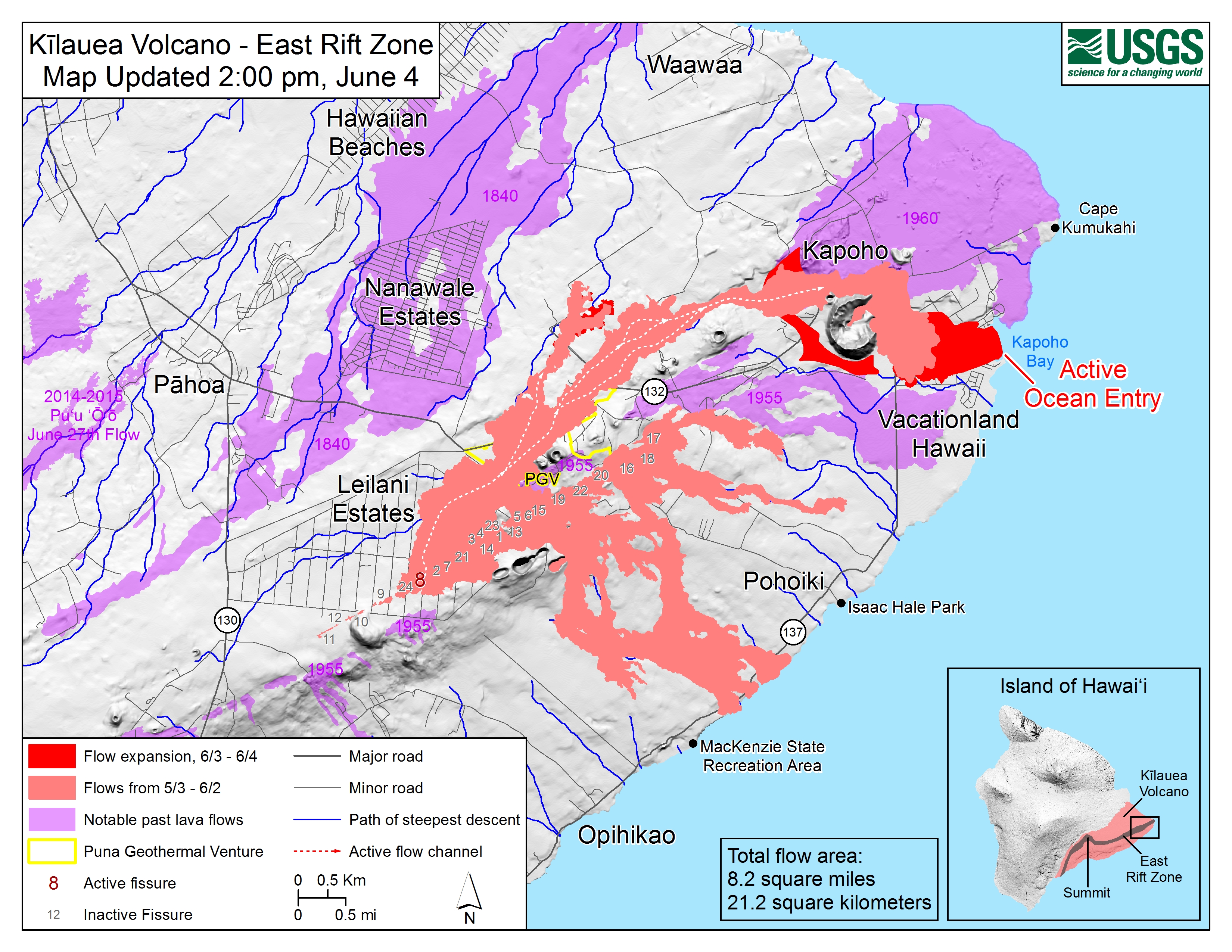
Kilauea – 2018-06-04 10:26:11
As of 6:30 AM overflight, lava has built a delta a few hundred yards into Kapoho Bay; flow front is about 0.5 miles wide; laze plume blowing onshore but dissipating quickly; small breakout above Kapoho cone cinder pit.
no words….. just sorrow…………Just some ideas to consider: i may be in the minority but i don’t think showing dead bodies is disrespectful. It is in fact recognizing what they went through. Joining them in their humanity. Honoring our oneness. The disrespect comes when one ‘gawks’ at the pictures for the horror of it. Being upset with pictures of dead bodies is considering ourselves and not the people who went through it or their families. just something to consider and in no way judging anything said here… just something i’ve been thinking about for sometime…. In recognition, motsfo.
Gore for the sake of gore is perverse. Illustrating the gravity of a problem is different, unless it is pushed to the extent of being a gore fest.
The situation in Guatemala is dire. And this is about as close as you will see VC asking for funds… specifically, donate to the cognizant agencies dealing with the problem. That’s the best way we can help.
Also, a cautionary item. Scamming weasels will always show up misrepresenting themselves as charitable organizations.
Verify who you are dealing with.
ok.
It happens to the Gulf coast and the Caribbean all the time. We get lots of hurricanes, and invariably someone will do a mass mailing asking for money.
Lurking is right.
I cherry picked two such organizations since I have met them time and again out in far away places doing a lot of good. And the funds go where they are supposed to go.
I am a bit biased towards the Medecins sons Frontiers due to my wife.
There are though a few other organizations that also do a lot of good relief aid.
My best wishes to you Carl, and to all in Guatemala.
Pingback: Uitbarsting vulkaan Fuego – De Geobronnen
News item from ABC News Australia. They are an amazing part [of] nature, but I’m glad I don’t live near one.
http://www.abc.net.au/news/2018-06-05/guatemala-fuego-volcano-death-toll-climbs/9834448
I am sorry to hear about what happened. I hope Carl and his family and all the people hurt by this eruption will be fine.
After watching natures show for the past month. This is a dark reminder that this beauty has a very ugly side.
I can only hope that it awes enough people to pick up the books and instruments and figure out more and better ways to protect.
Do you have a link through which we can contribute to the relevant aid organisations (local hospitals etc?)
This?
Thank you.
Regarding my comment above wishing Carl and Guatemalans well, what is this that appears below my post?
Pingback: Uitbarsting vulkaan Fuego – De Geobronnen
Is there a reason it is on my post? It’s leading to something with Erik Klemetti.
Thanks – curious why & how and what deep meaning it has.
Usually Pingbacks appear separately I think, probably it happened when you posted your comment… they happen when another page on the internet links here. If you look below the Dutch article, you see a link to this article here. At the end of the article it links to Erik Klemetti’s update on Fuego ‘for further reading’.
It is separate — note how it is an unindented, top level item — but the horizontal line separator that should be above it, between Clive’s post and it, is missing for some reason.
Flankeneruption. Fuego now has a big hole. https://www.facebook.com/photo.php?fbid=1725016550868267&set=gm.1750088495029316&type=3&theater&ifg=1
All the best wishes to you and your wife, Carl. I really hope she (and you) can pull through this terrible tragedy.
Those pictures kind of remind me of Armero….I really really hope the death toll won’t climb anywhere near that high.
I will make a donation ASAP.
Thoughts with those affected by Fuego.
In addition to, or, instead of, donating to disaster relief (depending on your preference), is there any where reputable to donate money towards volcano monitoring equipment for Guatemala?
Novel idea, but I have no clue. I don’t know if Guatemala has the same problems as other countries where seismic equipment is stolen for it’s metal content.
After Hurricane Ivan here in Pensacola, Florida DOT had an issue with keeping their emergency generators in place for the traffic lights. They tended to “walk off.” I chained mine to a tree.
Guatemala is a poor country so equipment might well “walk”.
Reminds me of one of the usage tips tgat came with my accelerometer. They listed disguising it as a rock to get a data pull on railway traffic patterns. I haven’t tried that yet, but I can get a decent data set by sticking mine to an old 12-18Ahr battery and setting it securely in some sand in the yard. (This was when I was looking at the “lawn dart” idea of placing a temporary sensor for an idea Carl had. My lawn dart idea seemed to be more dangerous than useful. Yeah, you can get great coupling to the ground, but you might impale someone in the process of deploying it.)
We also have an issue with copper theives. The most audacious one I know of was when the AC units were stolen off the roof of Santa Rosa county’s administrative offices.
Looks more like a slide. if it were a flank eruption it’s look mor elike this:
https://twitter.com/twitter/statuses/732984949209321472
Can’t get a much better example than that.
M4.5 on the coast of southwest Greenland. GIven the location and time of the year, this is most likely a coastal collapse similar to the one a year ago, triggered by melt. The one last year triggered a tsunami with a run-up height of 100 meters. The lake/fjord that today’s quake was on is probably uninhabited.
https://ce.gatech.edu/news/after-recon-trip-researchers-say-greenland-tsunami-june-reached-300-feet-high
Very sorry to hear about Fuego .My wife’s chair as I sit here, has a Guatemalan throw on it.
She spent time there in the late ’70’s . She loved the country and it’s people…
There is a breakout that has gone south of the Kapoho crater that looks it could hasten the demise of Vacationland.
The lava flow from fissure 8 has slightly contracted since yesterday (comments on previous post). The flow rate may be going down a bit – one can hope.
Not according to HVO, they are saying the flow rate is increasing… Very slowly but it isnt letting up at all. The channel is getting narrower because the outsides are cooling and concentrating to the faster flowing portion. It is the same as how lava tubes form except exposed to the surface.
You may be right, But the latest HVO information that just came out states ‘Multiple observations from field crews and overflights suggest the Fissure 8 fountain is less vigorous this evening..’
By now the eruption seems to be approaching the 1840 one in terms of surface area.
It is 21.8 km2 in area as of last map, which is probably already outdated.
Given that new magma started erupting in a big way on May 18 ( 19 days ago) and the area before that was about 3 km2, that means the eruption covered 19 km2 in 3 weeks. Apparently the 1840 eruption lasted for about a month (27 days) and covered 20-22 km2 in area so this eruption is probably the biggest eruption on the lower east rift in the last 2000 years, despite the relatively low fountain height compared to 1960.
2000 years is a long time. There are some big scoria-spatter cones in the Leilani area like the 60 m tall Puu Kaliu (at least before being quarried away) or the not much more smaller Puu Honualua. It is difficult to tell if there are other important cones belonging to the same fissure event but at least in Puu Honualua there is a line of spatter cones extending to the east of the main vent. The two eruptions should be younger than 1000 years BP and I’d say they would have been comparable in size to the present eruption. The problem is that I dont think the extent of their flows has been studied.
By the way Puu Kaliu is very strangely looking, to me it is more like a 700000 years old eroded dome-like scoria cone I saw at the closest volcanic field to where I live.
That is land surface covered. Part disappears into the sea…
I am not sure about how lava flows behave after reaching the ocean but I think that they build lava deltas at sea level that at some point if they grow too big will collapse and it is then when the fragments of the flow will be lost to the sea. So the lava flow would then stop at the delta and go no further only the lava breccia would sink into the sea. Also given that the water is relatively shallow around the 1960, 1840 and the 2018 Kapoho ocean entries I would say that the subarial extension is what really matters.
Thedustdevil HVO themselves have reported that the 1840 flow is the biggest eruption on the lower east rift in the past 2000 years. What that actually means is the shortest time to erupt the most magma. 1840 lasted a month and erupted 227 million m3 of lava.
Pu’u kaliu and pu’u honuaula are both not actually much bigger than the current cone forming around the active vent now. They look bigger because both are sitting on a ridge that boosts their height while the current cone is standing alone. The flow field for pu’u kaliu is about 14 km2 but up to 15 meters thick. That eruption was quite big but not the ‘fast and furious’ type as that wouldn’t stack the flows that much, it was probably relatively long lived (at least a few months up to a year) and likely episodic with similarities to the first few years of the pu’u o’o eruption in the 1980s. It looks old because it has been quarried a lot for scoria to use in roads. Pu’u honuaula apparently erupted a lava flow towards the kapoho area because a lava flow from it was used to give a maximum age for kapoho crater, which overlies that flow, so the flow from pu’u honuaula probably looked similar to the one from this eruption but maybe a bit smaller. Again it is built on a ridge, I haven’t found any information on whether the ridge was made in that eruption but it is likely that some of it was pre-existing looking at the fault lines going through it. Judging by its closed shape with no outflow channel it probably formed towards the end of its eruption.
The last time I saw a measurement of how tall the current cone is was a few days ago at a minimum of 40 meters tall but 3 days ago the cone was half as old as it is now so it could well be 50 or 60 meters tall at this point and the fountain is 80-100 meters tall so the cone can still grow a lot more too.
The sea drops off where pu’u kaliu flows enter the ocean, so it probably never had a big lava delta. The flows in kapoho now as well as 1960 are flowing over shallow tidal ponds from a lava flow about 1500 years old, which is why they built out so far into the sea so quickly. Once that happens the lava deltas will grow very slowly and stay small like the pu’u o’o ocean entries did.
I think that in the map I was looking at Puu Kaliu hadnt been quarried yet and it already looked weird then. If you measure its height over the closest spot of the ridge it really doesnt matter if the cone is on top of the ridge or not. It still rises 60 m over the ridge downrift from it and it may have been more before the 1790 flow was emplaced. It rises almost 60 m at the opposite slope and more than 100 m from the southeast.
I dont know how could anyone get the extension of the Kaliu flow since it is the oldest exposed major cone-crater structure of the lowermost east rift area maybe with the exception of Puulama and Kahuwai craters (the Malama fissure) which may be older. This means that the flow field has been buried by several more recent flows like the 1790 flow or the Honualuha and Halekamahina fissures. Puu Kaliu is on top of the ridge and so lava flowed south, north and also probably east when channelized by the graben structures of the area. The south part may still be discernible but any of the flows going east or north are completely buried. And also the length of the fissure associated to Kaliu is unknown
(there has to be a fissure but all other spatter cones belonging to it must been buried or not identified).
I see some morphological similarities between Halekamahina, Honualua and the current eruption and I think that Puu Kaliu must have been similar too. I was considering just volume not the eruption rate and based in volume I dont think Halekamahina or Honualua are much more smaller than what we are seeing and that Kaliu was maybe even larger.
HVO makes the new cone 35 meters high: your estimate seems a factor of two too high. The lava fountains are now 50 meters tall and get above the cone but not by much.
Regarding prehistorical data, these refer to visible and datable flows. Parts of flows lying underneath younger flows are not included. As Pune resurfaces itself every 1000 years, that means that flows older than 500 years are underestimated and older than 1000 years will mostly be missing. There is solid data really for a few hundred years only. That is nt enough to know what is ‘typical’.
I wrote that before I checked the HVO updates for today, so I thought the fountain was still 100 meters high or somewhere around there. I do remember seeing something about the cone being 40 meters tall though but that could have been a false estimate.
The reason I said that the 1840 eruption was the biggest eruption on the lower east rift in 2000 years is because HVO have said that themselves.
I would agree that pu’u kaliu was definitely a bigger eruption in total size, but what I meant by ‘biggest eruption’ is that the 1840 (and to some extent the current eruption) is the fastest developed lava field that we know of. 1840 is all one flow and we know exactly how long it lasted for, and the volume is somewhere between 200 million and 300 million m3. Pu’u kaliu is about the same volume or a bit bigger but it was not one flow which indicates it was active for much longer and with more intermittent eruption. I also think there would be some exposure of its lava somewhere on the north if it flowed over there to a significant degree which would have been taken into account in measuring its surface area. Based on the presumption that it was episodic (likely given the presence of repeated flows) then there was a point where it was as big as the current cone and that point was likely more than 1 week into its life, so maybe we are just not patient enough and this current cone will be similar. 35 meters in a week isn’t bad, I think that is probably about what would be expected from how the eruption is going so far. Its probably going to get bigger.
I think that the Kaliu eruption was considerably bigger than the 1840 eruption in terms of volume. It is said to be at least 12 km2 and commonly 15 m thick or more. With this you get a volume of 0.18 km3 which is almost what the volume of the 1840 lava flow is estimated to be. But those 12 km2 are more or less what the lava field inmediately south of Puu Kaliu covers. For an eruption happening at the top of the ridge it should be expected lava flows to go both south and north. All the flows going north are buried now under more recent lavas but at some places to the east and to the north flows estimated to be the of a similar age to Kaliu are exposed. It is very difficult to know whether these flows correspond to the Kaliu eruption or not but at least some of them should belong to it. Also all the recent fissures of this segment of the rift (“1790”,1840,1955.2018) have been very long in terms of size so what are the chances of Puu Kaliu being the only vent of the Kaliu eruption. It was the main one and probably more than half of the lava it produced went south. But there where probably other vents along the LERZ and also a important part of the lava flowed north.
Puu Kaliu rises 60 m over the surrounding current ridge which is probably higher than it was then and rises even higher from the north and the south reaching more than 100 m over some spots so for now fissure 8 is smaller but it can still catch up since we dont know how long the eruption will keep going before it ends.
Puu Kaliu before being quarried. Hard to imagine where the crater was 😕
I think that with the quarry now it would be easier to see it.
I read something about another eruption happening very close to it a few hundred years later and partly covering the original cone, so that is probably why it looks like that. The area between pu’u kaliu and the craters to the east was where the 1790 eruption happened so that could have smoothed over those vents
The comment from HVO comes from a paper that makes the provisos. HVO will report measured numbers rather than estimates, so it would normally give the known flow areas, not the possible areas underneath younger flows. Another issue is that if a prehistorical eruption had two fissures, in the data it may well appear as two different eruptions, since how do you know they came from the same eruption?
do we have a landslide expert around ? – could scoria slopes be treated in much the same way as avalanche control use howitzers to set off avalanches in a slightly more controlled manner – would volcanoes with steep repose angles and fresh deposits behave in a similar manner – or does rock not compare well to snow in these circumstances?
Geoloco might have a clue, but I haven’t seen him around lately.
[fiximated]
yes GeoLoco was who I was thinking of – couldn’t think of his name. For that matter I’ve not seen Diana recently either (perhaps they have eloped to a volcanic island).
I think it would spark some controversy if we suggest to trigger bigger threats, that would leave people homeless, destroy farmland and businesses. Even if there is some logic to it..
“eloped to a volcanic island”
Hopefully not lower Puna. However, stranger things happen on the Net.
The greatest difference in the two that I know of is that snowfall can easily develop weak layers prone to shear with more solid material on top. This yields slab like failures of the snowpack as it comes down.
[fiximated]
Hmm… WordPress thinks I’m a different person. This is GeoLurking.
[fiximated] ← not a real word.
I’ve fixed the misidentified me from last night.
I knew it was you from your IP, although I was getting an IPv6 address before – it’s now v4. Plus I recognised your spoof email address.
Yeah, it’s one of my favorites. I had made a comment on another WP blog that I didn’t want connected here and forgot to change back.
For all, my favorite “spoof” address is an old Email abuse reporting address. It used to be that when spammers were reported to it, their network backbone feed was pulled until they proved to their service provider that they would behave. For some odd reason, the reporting address is still valid and will receive Email but I don’t know if it is even monitored anymore. I used to embed it as hidden text in web pages I authored where only web spiders would see it and add it to the Email target list they were gathering. Sort of an informal personal land mine for them.
And yes, if I’m “not nice” somewhere else I don’t think it should reflect on VC.
No, I wasn’t mean, I just stated the obvious.
Occasionally pointing out truisms to someone sort of pisses them off. No need for retaliatory action against VC.
As for the address change, I had just switched into a different network on my phone. I didn’t bounce my comment off of a proxy address to mess with the admin. (though I have done that before to a friend of mine just to see how he would react.)
Test.
And since I’m done being a jerk elsewhere on the net, I’ll relay some oddness from broadcastify. Somewhere on the big Island, there were reports of powering arcing and an eventual outage in that area. No idea if it’s puna related, but it did scare a few callers.
Volcanic gasses and electricity are like gasoline and fire. Which is why volcanic lightning looks so spectacular.
I am not sure about the context but this would be the first time it causes issues like this.
I think it only makes existing lightning worse but not cause it. So blaming puna is a bit far fetched.
Well there is a pretty massive pyrocumulus cloud above fissure 8. Usually they form over big fires but a lava flow might be even better, and they are known to become thunderstorms sometimes.
I wasn’t thinking of a lightning connection. I was wondering if perhaps magma is pushing over power poles and causing physical tensioning of the lines and yanking them off of the poles.
https://www.facebook.com/photo.php?fbid=10155976836394843&set=a.42543314842.55501.539464842&type=3
A look at the eruption from a different point of view, maybe something to lighten the mood a bit and bring some distance to the eruption. Picture by Andrew Hara, from the summit of mauna kea.
I can start to see why there are reports of the 1840 eruption glow being bright enough to read a book under as far away as Hilo. This eruption is just as big as that event so maybe a few people are doing that now.
Wow that’s beautiful
If you can see the Milky Way, the light is definitely too faint for reading!
Yes well I suspect the 1840 reports were exaggerated somewhat too, but people in Hilo have reported that the glow over the past few weeks has been very visible so maybe there is something to it.
Beautiful! A view of my two favorites, volcanoes & stars.
https://www.facebook.com/USGSVolcanoes/photos/a.984262971602264.1073741827.984239038271324/2053162014712349/?type=3&theater
On this page there is a comment by USGS where they say the eruption rate is about 6 million m3 per day over the last few days. That would bet 70 m3 per second. It is possible that it was higher during some of the earlier flows when the vents were less certain and often changed.
It is also probable that the eruption rate will increase in the coming days as would be consistent with the previous eruptions in lower puna once a main vent was established. This would be accompanied either by much higher fountains or by lava erupting from other fissures nearby, or both if it is really intense. Neither is really a good option if your house is downhill…
At that rate, the eruption will be approaching 0.1km3 which is typical for a Puna eruption. The reason it has covered so much area is that is has ‘leaked’ into two different directions, down to the southern coast and along the rift. If the eruption stays fixed, the area should not increase dramatically anytime soon. If another fissure uprift goes,all bets are off.
There are still some occasional outbreaks to the north. If those manage to reach a slope downwards they can still add some reasonable surface.
5.6 now
It might be typical in size, but it follows a very atypical situation at kilauea with the 30 years of continuous eruptions at pu’u o’o. That throws a massive wild card into the mix that shouldn’t be taken out of the equation. For pu’u o’o to have erupted for so long there had to have been a large open system in the upper rift that will contain a large volume of fresh magma, and all of this is what is erupting now. The stuff from the summit hasn’t even got to the vents yet but when it does it will probably be relatively brief but intense. The fact that the rift zone isnt deflating means that there is still new magma moving into the area which means the eruption can continue at the pace it is now for a while, and when very gas rich summit magma erupts it will probably cause higher fountains.
5.5 at Kilauea
Coordinates:-155.2936, 19.404
Depth:1.45 km (0.9 mi)
Magnitude:5.5
Date:2018-06-05 10:32:27 local
2018-06-05 14:32:27 UTC
Age: 0 days
Distance From:6km WSW of Volcano, Hawaii.
This one was predicted by HVO.
In the public record?
Yes. It was in the update a few hours before the event.
I did hear in one update that they expect the next one in 24 – 48 hours.
The BBC’s look at why Fuego’s eruption was so bad. They blame it on the pyroclastics which was clearly part of it. The mention of lava has now gone. I am unsure whether any lahar was involved: the BBC report does not mention it.
https://www.bbc.com/news/world-latin-america-44369461
This video is just terrifying. https://youtu.be/rQ0x26PT3JE Prayers to all involved. 🙁
And we were commenting on how dangerous it was to film a lava fountain. Wow, this is much worse.
One thing puzzles me here if the flow resulted from collapse of a vertical eruption column, should there not have been several PFs distributed radially from the summit rather than a single vigorous flow down one narrow channel? Was the shape of the crater (eg a breach in the crater rim) a factor?
Logically, yes. Prevailing wind tends to push the column to one side of the edifice and when the thermal energy keeping it aloft fails, you get a gravity driven surge down one side.
That is what I was wondering about too. The pyroclastic flow must have originated high up the mountain, quite near the summit.
Vesuvius 79 AD was similar. Prevailing winds dropped the column on the southern face and killed the towns on that side. Including Pliny.
Think I might (might!) have a possible answer to my own question Phase change Courtesy of, I think, the late Peter Francis, -not my idea, can’t claim it Initial explosion, highly energetic, debris goes up, high eruption plume As eruption proceeds, energy level declines, at some point abruptly becomes insufficient to lift the material much above the crater rim, whereupon it overflows to move downslope If there is a crater breach it will go through that breach as a single, powerful flow This mechanism will produce a very high temperature flow -straight out of the vent, not subject to the chilling effect of a brief trip to the stratosphere and back Would this idea work?
Well, yeah since column height is a function of heat output. That’s how the Mastin et al and Sparks formulas estimate mass rates. Also why they don’t work as,we for purely phreatic events. (And why I quit doing DRE tallys)
Caption has been changed. Thanks.
__________________________
askHVO@usgs.gov
U.S.Geological Survey
Hawaiian Volcano Observatory
http://hvo.wr.usgs.gov
On Tue, May 29, 2018 at 8:51 PM, Peter Vervoorn wrote:
I think you may have incorrect information on the blurb underneath the PGcam. It says “From left to right, one can see the eruptive fissures, with Fissure 15 on the far left, and Fissure 10 near the center.” Surely the large fountain near the center is fissure 8 and not fissure 10? Fissure 10 would put the source of the active lava flow 1.4 km west and uprift of fissure 8, endangering 6 blocks west of the main flow.
that notation made by HVO was correct as it was made before 8 went nova…. 10 was the dominant at that time. Maybe 9 will be next…. 10 looks shorter(but wider) this morning to me… Best!motsfo
Not sure what you mean; but I’m glad they changed it to read fissures 15 and 8. It was misleading for too long.
and i meant 8 was shorter and wider….. i should know better than to try and communicate before coffee…… 😉
Me too. I’m going back to bed. 🙂
To the best of my knowledge fissure 10 has never been the source of a fountain. The post above is the email HVO sent thanking me for pointing out the mistake and advising me of the correction.
Is this just paper trash or could it be true that the Army may ue bambs to divert the lava flow ?
https://www.express.co.uk/news/world/969886/hawaii-volcano-eruption-latest-mount-kilauea-us-army-bomb-lava-flow
I suspect it’s paper trash.
At one time the military has tried such action, but we had quite a surplus of bombs distributed out in various theaters and we’re using them on a regular basis anyway. There have been many decades of study and thought on the matter since then and there isn’t an urgent public relations mater that needs to be dealt with.
We just saw a whole town being swallowed up by it. If there were plans to intervene. That would have been the moment.
And I dont think any other towns wil be threatened now on except of course the rest of Leilani but thats too close to the fissures to atempt anything.
With now on I mean this eruption
Yes they drop a bomb into the lava and…? The lava will just flow on as if nothing happened. Even dropping a nuke into the vent would do almost nothing except kill everyone and make a hole which would fill with lava again in minutes. Nothing short of a tsar bomba is going to do anything to this eruption at all…
Express is notorious for their clickbaiting and alarmist articles. They shouldn’t be a certified news outlet as they are very irresponsible, at least talking about natural events. Everyone knows about the dailyfail but they aren’t the only ones doing it. YouTube comments are a much better and more reliable source than they are, and that is saying something…
Apologies ”may use bombs to divert the lava flow ”
i’ve heard it’s bad to mess with the flows… doesn’t help… only hurts in the long run. And how do You determine which person’s land to divert the flow too?? Eventually any messing with the flows makes them too deep/high and they then really become unmanageble. All efforts used to divert flows works better in Iceland and Italy. Best!motsfo
Some news;
“Hawaii County officials confirmed on Tuesday that a home owned by Mayor Harry Kim was among those claimed by the lava flow, which has already inundated most of Kapoho Beach Lots and Vacationland.”
http://www.hawaiinewsnow.com/story/38344763/lava-covers-more-subdivisions-while-pouring-into-ocean
Latest map for Kilauea Easr Rift lava flows:
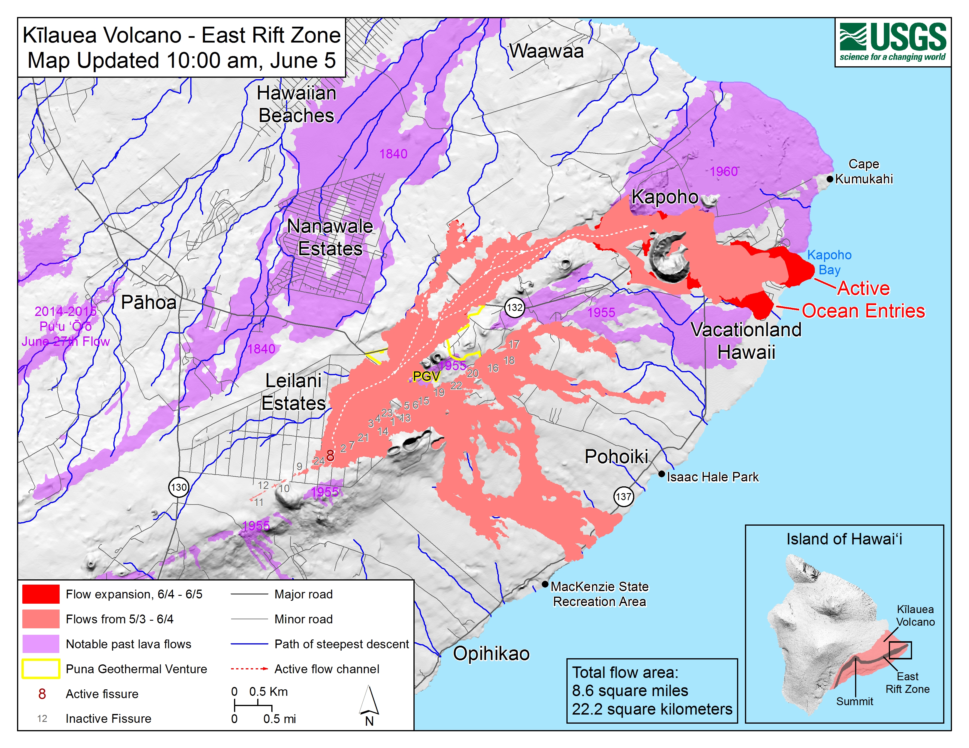
That doesnt look good for Kapoho
Well, that’s different. The drone operators just requested flight clearance up t0 2000 ft AGL to go look at Fissure #8 and Leilani Estates. Usually they only request 1000 ft clearance. My guess is that this is a damage survey mission.
something big going behind 8 and please look at the summit Kilueau crater while it’s clear.
and looking at the latest cam view from HVO there seems to be a large cloud of vapor/steam/particulate just next to but not connected to fissure 8…. Anyone? anyone? Best!motsfo
and now the view is obsured by smoke… looks like something is on fire close by… hope we don’t lose the cam.
Obscured by Clouds…
What’s giving the smoke a pink/orange tint on the left side of the image? Source of the image IS Geological Survey.
The lava you are seeing is the channel coming out of the cone. There is no obvious fountain at the moment. The steam comes from the cone itself which is right behind the lava channel.
Left side? OTH it was probably just something to do with the weather conditions.
and looks like the upper overview crater is even larger today….
I see these deep quakes under Pahala show no signs of stopping.
Latest https://earthquake.usgs.gov/earthquakes/eventpage/hv70235912
M 1.7 – 4km SSE of Pahala, Hawaii
Time
2018-06-05 16:59:17 (UTC)
Location
19.166°N 155.465°W
Depth
30.1 km
==-==
I’ve gone back and checked historically and from 2000 to 2009 no quakes were recorded at depth between 30 and 40km within a few km of Pahala. Then there was a 3.5 on 2010-02-02 followed next by a 3.1 on 2013-08-24.
Things picked up a bit with 6 quakes in October and November 2015 at 2 or above but we only really start moving in July 2016 when multiple 2+ quakes start happening monthly and that sequence has continued until now with an uptick in tempo.
As of now there are 15 quakes within 5km of Pahala on the USGS 7 day all magnitude map all at depth between 30 and 40km.
Retrieved from the dungeon – admin
If those earthquakes aren’t stopping then that means the magma supply hasn’t slowed down either, which means this big drain out of the volcano will not result in a prolonged dormancy like I’m 1924 but rather an intense period of eruptions over the foreseeable future.
Score one for me 😎
I am taking your score away.
Those deep earthquakes are related to a combination of downwards pressure from the weight of the volcano and after effects of settling after the big earthquake (M7+) a while ago. In other words, there is no direct causal relation between that seismicity and the ongoing volcanism.
The ongoing volcanism is regulated by the volume of magma leaving the shallow magma chamber residing under the caldera floor. So, the amount of earthquakes at the caldera is indicative of the ongoing volcanism as a secondary effect, visible as the ongoing blocking that is causing the current formation of the nested subsidence caldera feature destroying Halema’uma’u.
Trick is to know what is what 😉
It was actually HVO who said this deep cluster at Pahala, that has been active for some time (year) was a magma conduit. They saw a connection to Kilauea (in fact on the historical earthquake plots you can see a shallowing line from there) which seemed surprising as Pahala is better placed to feed Mauna Loa. But indeed, Kilauea inflated and erupted so HVO was probably correct. There are some settling earthquakes as well, but those are scattered around the island. Pahala is a definite cluster.
But the current activity is too late to affect the current eruption. The deflation shows that magma is lost from the chamber. It may help recharging the chamber once this eruption ends: it probably takes months to years for magma to get from Pahala to Kilauea.
I would be tempted to award the point to squonk who paid attention.
I wasn’t aware that HVO had commented on the Pahala quakes but suspected someone must have.
When I noticed they kept popping up I checked back a bit and saw that they pre-dated the approx 7 quake so I then used IRIS wilber3 to find all events since 2000.
I’ve also been rotating 3d earthquake views until my head’s spinning but possibly more of that later 🙂
This is the plot that shows the connection between Pahala and near Kilauea. It is the blue sequence, trending upwards towards Kilauea.
Be careful about extrapolating into the future using one data point. We have no way of knowing what the future activity will be. Just to be clear; I’m not stifling speculation and hypothesising about what might happen though, just not keen on self back-patting before the events have actually come to pass.
That is true except I have more than one data point 😉
This eruption is draining (has drained?) out the summit like in 1924. However 1924 was almost a record low in terms of magma supply rate per year, about 1.5% of what it is now. That is probably why the intrusion didnt erupt (at least not straight away) and maybe also why the current collapse was a lot bigger than the 1924 one.
On the contrast the last 10-20 years have been almost the record high of magma supply for kilauea, as evident by the 10 years of continuous stable eruption from two different vents. That is also evident by this eruption now.
I did some research and apparently the 1790 lower east rift eruption preceeded the better known explosive summit event, and given that both eruptions were similar in volume that indicates the supply rate was probably quite high for a time before that happened. After that there was a huge increase to the supply and the 500 meter deep caldera was only 100 meters deep 50 years later when the 1840 eruption started and things slowed down a bit.
If there is still magma moving into kilauea, as evident by the earthquakes, then this scenario now is much more reminiscent for the 1790 events so a similar increase in magma supply is likely, and at the very least the supply isnt slowing down so new eruptions will likely start within a few months of the deflation ending.
Eruptions might be restricted to the area between kilauea iki through halemaumau and down to mauna iki for a while though, as that is a shallow system that is within the upper 1 km of the volcano. Nice for tourism though.
There is also the interesting correlation between the end of the kane nui o hamo eruption, similar to pu’u o’o, and then the start of large scale summit overflows shortly afterwards (within 20 years). There is no actual proof of this but kane nui o hamo has a big summit crater like pu’u o’o and possibly underwent a similar fate with its magma supply being cut off by an intrusion downrift. That event could have caused a large volume of magma to be pulled into the volcano and lead to the summit filling and then extensive overflows from the observatory vent and then the aila’au shield. That idea isnt confirmed at all but the semingly close dates for the end of kane nui o hamo and the start of large summit overflows is a noteworthy correlation.
Also something noteworthy, kilauea can do and has done magmatic plinian eruptions, no that is not written wrong. It happened from the deep caldera that existed prior to the year 1000. The VEI numbers are unknown but most likely well into VEI 4 based on the thickness of the tephra. It is called the kulanaokuaiki tephra. These eruptions predated the first known settlement of the big island but some of the other islands were probably inhabited and might have seen this happen.
The two main phases of volcanic activity at the summit during the last predominantly effusive periods were Ailaau and the Observatory flows. I think there is a lot of uncertainty about their relative and absolute ages even about the estension of their flows or at least I have found conflicting ideas about it. According to HVO the observatory flows came first and then the Ailaau but in other places Ailaau was the first. In any of the cases I think there was a pause, a period o activity focused around the ERZ in between. Puu Huluhulu (the best candidate for a prehistoric long lived vent at the middle-upper rift after Kane Nuio Hamo but much more smaller) is newer than Kane Nui o Hamo at least if the Keauhou lavas which are more recent belong to it and probably they are. Puu Huluhulu and other activity at the lower east rift must have taken place between the strong phases at the summit.
A lake formed during the 1790 explosions right? Can another one form now if the overlook crater keeps growing?
There was a very interesting volcano watch article last year that said the observatory vent formed first starting around 900 years ago and the first overflows starting about 700 years ago. This 200 year period was probably similar to what the summit looked like a month ago.
The observatory vent lasted up until the caldera formed although it rarely overflowed after around 1400, which is about when aila’au formed. Aila’au is more certain because it still exists as a full structure and it flowed over a lot of forest (where it got its name, Aila’au was the original volcano god before Pele, the name means ‘the forest eater’) which has allowed radiocarbon dating. That vent was active over a roughly 70 year period where there was probably near permanent activity (lava lakes and small vents within the crater area), although the flow field was very likely created by many individual separate lava flows like at pu’u o’o, with gaps of probably a few years to maybe over a decade in between, basically there was active overflow probably less than half the time but it was big when it did happen.
I think the best date for the formation of the caldera is in the 20 year period between 1480 and 1500, which is when explosive eruptions became frequent and lava flows were rift restricted. The caldera probably didn’t form instantly either but in a more drawn out process a bit like now but on a larger scale.
The idea of there being a lake in the caldera before the 1790 eruption is inferred by the amount of water needed to cause a VEI 4 explosive event, but there is actually no proof of its existence at all as everyone near the caldera on that day didn’t live to tell the tale… That whole lake idea is also based on the assumption that water has to be there to cause explosive eruptions, an idea that has since been found to be false through recent observations of most of the explosive eruptions in the last month being driven largely by magmatic gas (vulcanian eruptions), as well as the discovery of a plinian air fall deposit in the kualanaokauiki tephra deposit in 2011, dated to about 800 AD (annoyingly the only papers on it are paid access only…). Maybe the reason there were footprints in the wet ash is because it was raining at the time, rather than because the ash was wet before landing, that area recovers a lot of rain, so much that it shouldn’t be called a desert but a rainforest, if there was actually a forest there (plants can’t easily grow there because of loose tephra allowing water to drain away as well as acid rain).
If HVO report discovering volcanic glass beads in the 1790 tephra then that throws a spanner in the steam theory, as the beads wouldn’t form if the eruption was through water (they would be more rough and irregular and broken-looking). It is unfortunate that nearly all of kilauea’s recorded history has been when it was in a low period of activity, if recorded history started in 1500 then kilaueas reputation as a ‘safe’ volcano would have been killed before it started, is might actually be one of the more hazardous volcanoes for that reason as there are several thousand people on it at any given time that would be in trouble if it really showed its true nature.
I just realised that the overlook vent filling the caldera was active over the same time as kane nui o hamo, so there could be another similarity between it and pu’u o’o, a possible stable summit/rift double eruption.
The crater that is forming now at the summit might not be deep enough for a lake to form, and probably isn’t going to last long enough either. The area has to cool down to allow water into the rock there and that will take a long time, and there will very likely be at least one eruption there within a year and the deepest part might get filled in by the east wall landslide moving towards it. All those steep drops and cracks are going to make for some interesting eruptions there over the next few years. Lots of lava cascades and maybe bigger lava lakes or events similar to the 1959 eruption.
Forgot to add that part in the last comment.
Update by USGS.
”Kilauea – 2018-06-05 18:02:08
HVO Overflight at 6:30 AM HST confirms lava extends 0.7 miles into Kapoho Bay; most of Vacationland and all but northern edge of Kapoho Beach Lots inundated; Fissure 8 fountain to 150′ but lava channel still full.”
https://volcanoes.usgs.gov/observatories/hvo/eruption_updates.html
Inundated sounds so temporary, like the magma is gonna recede when the flood is done. “Paved over” seems more appropriate.
USGS now has a Kilauea livestream running. I hope they stay live until the next big quake hits. Would be great to see a plume from this close and live.
I just made a comment about the ongoing sequence of quakes between 30 and 40km under Pahala but had a typo in my email address so it got stuck. If a mod could free it up that would save me retyping 🙂
Brief summary – I think the sequence started in February 2010 and has been building since then. Current quake rates are at the highest they’ve been for the region.
Wow…. live coverage…. https://www.youtube.com/watch?v=JlP-8JiKOS8
This is a live link also showing split screens including fissure 8.
Well, Janet, You young upstart ( 😉 ) You bettered me by 5 . Nice! Best!motsfo
Not so young old enough for my free bus pass 🙂
On the Pu u O a Crater screen is that something happening in the top right hand side of the screen or is it just dirt on the camera lens ?
Camera lens…. doesn’t change with the updates….. sorry….
It looked to me like a thin ash cloud column and I can see flashing black spots think it’s time for bed 🙂
Not to mention that now days, textual search programs can cross reference entire papers and trigger hits on similarities to previously written work. I think UUEdit even has a similar function in it. (It’s mainly geared towards scripting languages)
and one of my ‘library aide’ jobs was re alphabitizing the card catalog.
I retired last year, after 38 years of librarianship. From card indexes to Google. I’ve seen most of us lose our jobs over it. Sadly, the Google generation have absolutely no idea how to find information.
[redacted]
Looking at the PG webcam it almost looks like 2 fissures’ an optical illusion maybe.
Kept back for approval by an admin. Future comments should now appear without delay – admin
Here is the summit of kilauea today. Basically the entire area between the overlook crater and the edge of the main caldera (including all of pre-2018 halemaumau) is falling into the deep hole created by the collapse of the overlook crater. HVO is saying this is because of ongoing summit deflation but it looks like it is going too fast for that and a lot of it is probably from that mass of rock sliding into the pit, basically a massive landslide.
It has done all of this in the past 3 days… This time next week the deep pit could be filled by the slide and replaced with a much wider and more shallow depression.
The question now is whether this is still called halemaumau now that the old crater has been entirely consumed by the collapse.
It is interesting that the collapse and landslide seem to be going along the trace of a shallow magma system that extends from kilauea iki through halemaumau and down into the southwest rift. It is not impossible that more pit craters could extend along the upper part of the southwest rift and towards kilauea iki, a new chain of craters if you will. That might shift the eruptions more in that direction for a while which would be a big change. It would probably be a change that a lot of people would welcome though as it would be much less destructive to property compared to what is happening now.
Hopefully in that scenario people dont become complacent with the east rift again and forget that it is still active.
This is a picture I made roughly showing what is happening.
The red solid area is where the lava lake was. It might be a bit small but its close enough.
The orange line is the rough area of the deep pit as it was in the last overhead picture (a few days ago so probably outdated now)
The yellow is the landslide area that is falling towards the deep pit, based on the outermost cracks on the last overhead picture from HVO.
The pink dot is HVO where the webcam is.
Now that the barrel of the cannon is loaded, I wouldn´t want to be anywhere near the summit when the next blast happens. I think the new webcam has a short life expectancy.
There probably isn’t going to be another big explosion. When the explosive eruptions were happening the crater was actively collapsing and getting deeper. Now it is being filled in again by a landslide that is moving in from the west. There will likely be more explosions but not really big ones. The crater was also enveloped in steam while now it is mostly cleared.
There was already one explosion that exceeded the height of all the 1924 eruptions, over 10 km high on May 18, so this ‘big one’ that people are talking about has already happened.
The summit show is probably over for the most part, if you want to see something, it would be better to watch the east rift vents, as it is likely for high fountains (200 meters+) to develop at some point based on the cycle of activity at other puna eruptions in historical time.
“Hopefully in that scenario people dont become complacent”
Don’t count on it. The government mandated insurance coverage will finance reconstruction and the whole process will repeat itself in the future.
That is, unless the new lava flows are incorporated into an expansion of the park system. In which case, the previous land owners would likely be compensated for the land via imminent domain law. IMO, any remuneration should be based on the usefulness of the property as it now stands rather than on what it was before the Pele’s 1000° bulldozer rolled over it. I’m pretty sure that the point will be a source of argument in some courtroom if it happens.
I would personally like to see at least the fissure 8 cone and surroundings be turned into a park, as it is somewhat of a more significant vent structure than most of the other fissures. The fissure 17 cone might be even taller but I think that is still on mostly useable property so that one might not last, especially if someone builds their house on it.
I guess if lava tree state park gets buried (not unlikely) then people will probably want to make something of the new eruption as a replacement.
Even though this eruption might fade from the main view over the next few decades, it is unlikely to be forgotten due to the attention it has received. If someone wants to build their house in those places again then there isn’t really an excuse now. Maybe the impact this eruption has caused will make people reluctant to live their again and the community will make it a park, community efforts have been the biggest player in how this scenario is playing out, and a lot of people (probably the majority) have respect for the culture and so will probably want to preserve that by not destroying the eruption site to rebuild houses in those places. That is something that was far less influential in 1955 or 1960, when everything was really pretty blunt and most people moving to Hawaii probably just thought of it as some exotic islands that America had come to claim ownership of, and they needed somewhere to live so random plots were made with little regard to eruption potential or cultural significance. I would be surprised if there are any pre-contact settlements in the puna region, the natives knew exactly what happens there and probably stayed well clear of it as much as they could. They were there when the average eruption rate in that area was once every 10 years or less so it must have been a frightening place to be.
One would indeed hope for common sense. Kapoho is gone and won’t be rebuild: there is nothing green left there. A few houses backing on to the 1960 flows have survived so far, but are left with no access, utilities or attractions. Half of Leilani survives but with a life expectancy measured in decades.
There was certainly a lot of Hawaiian activity in the area: that is how so many were killed in 1790. Kilauea shifts its activity around and living memory may not be long enough to know what it can do.
On the otherhand. We cant just stop living in hazardous areas. If its not Lava. Its Earthquakes, hurricanes, floods and tornadoes. The US would lose most of its mayor cities if we banned people in areas that are at risk of a mayor disaster in the next 100 years.
I think that if the people are informed and prepared, and with some clever city planning and disaster mitigation. People should be able to live there.
Hear hear!
People tend to forget that the best soil and living conditions normally comes with a sign attached “here be dragons!”
“Here be Dragons” one of my favorite map notations…. (on the edge with some fire breathing cartoon) 😉
I have to disagree with having new pit craters in the upper southwest rift. The east rift has an intense recent history of big collapse craters forming there but the southwest rift has none in fact the summit caldera complex is the westernmost pit crater of kilauea. I am talking just about magma reservoir collapses since there are other mechanisms that can cause smaller pit craters to form.
The craters of the ERZ reach their maximun density and size around Napau with Makaopuhi, Napau and two other large ancient pits now filled. Thats what makes it so unique the fact that these are not just an extension of the shallow summit reservoir (which is what happens at Mauna Loa) but an independent feature. The east rift faster dilataion, episodes of long lived activity and the pit craters are all probably related.
If a pit crater forms somewhere it will be in the summit or the ERZ. I think that a large collapse at the summit or craters on the upper and middle east rifts would mean the interruption of the shallow conduit that has been the main feed for the activity of the ERZ up to now and then the activity would focus back to the summit, Kilauea Iki and the SWRZ. So I also think activity could return there but only if the collapse is large enough and if the the Leilani fissure keeps going enough too.
The idea of pit craters forming along that section is because a shallow magma system exists that connects halemaumau to kilauea iki and the western half of the SWRZ st a shallow depth. This is why the 1823 and 1919-1920 eruptions happened so passively and why deformation was recorded between halemaumau and kilauea iki during the 1959 eruption. If the magma has drained out of the upper conduit in halemaumau then it has probably done that over the whole upper part of that system. My idea doesnt mean really big pits will form but smaller ones maybe 100-300 meters wide. Given the way they form it could be a year or more before the cavity reaches the surface. The fact that there are no pits on the SWRZ now and lots on the ERZ is probably not a good reason why pits cant form on one or the other, especially as both areas are almost entirely less than 1000 years old. Mauna ulu is a good example of how fast even big pits can be filled too, alae was the second biggest crater on the east rift and it was mostly filled in a few days…
I quickly drew this picture to show what I mean.

The black areas are pit craters (in rough location), the blue areas are major vent s structures (also in rough location).
The red areas are the eruptive areas on the rift zones, the orange is mostly non-eruptive although eruptions can happen in this area sometimes. The purple is the caldera outline.
The bit I am talking about in the previous paragraph is the green area, which is connected at shallow depth to halemaumau and which likely has drained with it in the last few weeks. The slumping of the crater towards the east as well as a lot of the collapses on the east wall have both followed this line quite well.
Mauna Ulu was a very voluminous eruption much more voluminous than what I think the southwest rift is capable of doing. Alae wasnt the second largest crater, Napau was, it was also partially filled during Mauna Ulu but it survived that one and other eruptions coming afterwards. I agree that Kialuea Iki has a shallow connection and that it will probably collapse again but there is no evidence for shallow reservoirs at the southwest rift. Both Kilauea Iki and the middle ERZ have suffered repeated collapses. Kilauea Iki is a compound chain of craters formed in different moments and in the ERZ there are craters older than Kane Nui o Hamo (a crater west of Makaopuhi with a similar size is under Kane Nui o Hamo lavas) then there is Napau and Makaopuhi more recent but with abundant vegetation and then the most recent craters: West Makaopuhi, Alae, Aloi… I have seen somewhere that Alae and Pauhai were compound craters too. And theres Puaialua which could be older than Kane Nui O Hamo too if the geologic map I have looked at was right and for some reason the lavas didnt inundate its crater, an old shield then?
But the southwest rift has no known pit craters and a behaviour resembling a typical rift with narrow punctual dyke intrusions that lead to short lived eruptions like Keaiwa 1823 while Kilauea Iki and the Middle ERZ have experienced long lived events like Ailaau or Pu’u’o’o probably sustained by wider conduits made up of connected shallow reservoirs? At least the conduit said to belong to the 1919? Kilauea Iki eruption was very wide and shallow when exposed during the summit collapse afterwards.
The southwest rift is divided into two parts, although they are not technically different. The southern part is called the seismic SWRZ and it is a deeper structure that seems to be relatively recently formed. That is the red area on the map I made. The green area is the part where most of the eruptions have happened, and is known to be connected at shallow depth to halemaumau because of the 1919 mauna iki eruption. The 1823 eruption also happened because of this. The green and red zones sort of merge further down where the great crack is, which is why the 1823 eruption happened among cones formed from more deep seeded eruptions.
Given the way the current collapse at he summit is going, it is not impossible that some of the flank craters formed the same way, with an initial mostly circular collapse followed by the side sliding down and giving the appearance of two conjoined craters. This isn’t the case for all of them but could explain some things.
Also napau is the second biggest in diameter but alae was a bigger volume, and yet it still got filled mostly within a day. Mauna ulu was a very big eruption, but a number of other eruptions could have done it too, at the point where it filled alae crater mauna ulu was still a fairly typical eruption in that size range, similar in size to the current eruption in leilani estates. The apparent much larger size was because it wasn’t erupting continuously, with high fountains being some weeks apart. Had it been continuously flowing it would be similar to the current eruption.