
Gunung Agung during the eruption. Photo by Emilio Kuzma-Floyd (http://www.eyesofanomad.com/)
Most people have by now noticed that Gunung Agung has stopped erupting. And to understand why that has happened, and what will happen soon, we need to look at what happened during the eruption. We also need to look at what is currently happening.
When a volcano is showing no visible signs of activity, we have to turn to instrumentation to understand what is going on where we can’t see anything.
But, before that, we must look at what a volcano is at its most fundamental level.
Volcanoes as energy transfer systems

Tempel covered in ash. Photograph by Tangkaswara TP.
Most people tend to think of volcanoes as outlets of magma, but the magma is just a way of transporting energy. In mantle plume volcanoes this energy has travelled from the bowels of Earth, at spread centre volcanoes the energy is transferred from the mantle, and in subduction volcanoes that energy is caused mainly by friction from the subducting slab grinding against the thicker upper crustal part.
Now, many will say that it is lava that is squirting out. Well, yes it is lava that is squirting out, but the greatest difference between lava and your average garden rock is heat. And heat is a form of energy.
So, any volcano will be a basic energy transfer system. But, the magma type does have effects of how the volcano will erupt. The energy transfer affects when, size and type of eruption in combination with the type of magma involved and the involved volatiles residing in the magma.
These combinations are affecting the behaviour of every single volcano on the planet. Sometimes two close by volcanoes erupt in completely different patterns and ways due to this.
Gunung Agung as an energy transfer system

Current tremor chart. Image from Badan Geologi.
Agung is a subduction volcano of a fairly ordinary type. At depth magma accumulates at a point called the accretion zone, it is where melted subducted rock pools complete with its molecular components and energy in the form of heat.
This pool of magma will take on characteristics of the subducting plate. If it is water rich the magma will be water rich, if it is rich in metals and sulphuric compounds the ensuing magma will also be that.
Due to the heat the melt will weigh less than the rock above, so it will be buoyant and try to migrate upwards like a hot-air balloon.

Heavy volcanic tremor episode. Image from Badan Geologi.
In the end that balloon of hot magma will enter the magma chamber of Gunung Agung and it will start to expand, both from the heat increase and the volume of the fresh magma. There will also be considerable exsolution of volatiles as the magma nears the top of the magmatic system.
In the case of Agung the magma is rich in silicates, water and sulphur. The magma at Agung is of a highly silicic type called andesite. That means that the magma is sticky and prone to being able to contain substantial amounts of water and gas before fracturing. That makes it potentially very explosive as it comes out.
What has happened at Agung?
Before any visible signs happened at Agung, scientists started to pick up small earthquakes and see a slight inflation of the volcano indicating that new magma was entering the system. In this case they knew that Agung was reactivating about a year prior to the current activity.
This made it possible to increase the monitoring and start to produce more detailed evacuation maps. At the same time local authorities started to consult with the scientists to prepare for what would potentially come. As activity increased over time these plans became more detailed and the local population was informed about evacuation plans.
As things progressed even further an exclusion zone was put into place and people where evacuated from the mountain.
After that the volcano started doing what volcanoes do best, and that is erupting. The opening stage was a hydrothermally driven phreatic detonation that lasted for a short while. After that the volcano returned to a more restful look.

Sulphur cloud caused by Gunung Agung. Image by JPL/NASA.
A phreatic detonation is when increased heat from below rapidly heats water inside the mountain causing steam explosions. This often clears out an upper conduit through the mountain that the magma can follow at a later stage.
During this interlude the seismic signals and inflation continued and increased until the mountain finally erupted by ejecting fine grained tephra and prodigious amounts of sulphurous gases. This eruption phase has been calculated to have been a small VEI-3 with 0.012km3 of ejecta.
Here comes what is rather unusual. A second vent opened up after a couple of days, and pure steam came gushing out next to the vent ejecting the tephra. This can be seen on the video above. Normally all water has been boiled off from a volcanic system prior to the magmatic phase, but here there must have been a rather powerful aquifer or water body next to the volcano that took to long time to heat up to an explosive level.
In the end the shear volume of water quenched the andesite in the conduit and a glassy plug formed that corked up the eruption completely. This is among other things measurable on sulphur gas output that has diminished quite a lot from during the eruption phase.
What is happening now?

Daily life near a volcano. School children going to school outside the exclusion zone.
After the eruption there have been almost daily episodes of violent tremor caused by ever more increasing pressure inside the volcano. This pressure is caused by the energy in the form of heat causing the old magma in the system to expand further as it heats up, and it is also caused by more magma entering the system.
This tremor has been very large compared to other similar systems, so we do know that the rate of pressure increase is high. There has been a lot of volcanic type earthquakes also, and that is another sign of increasing pressure.
What will happen?

Evacuation being enforced by the Indonesian authorities. Photograph by Humas Basarna.
The shear intensity and duration of the tremor episodes tell a story that it is in the long run impossible for the quenched plug to hold back the lava. It also tells that the plug is very solid and sitting very firmly in the barrel of Agung.
This is potentially bad news. Either the plug will start to slide up and form a dome or a spine before being blown away. Or, the plug is so firm that it will shatter inside the conduit and come out explosively during an explosive phase.
And the general rule is that the longer time we must wait, the larger the ensuing eruption will be.
Currently the seismic signals have quietened down, this is normal prior to an eruptive phase. But, it is also possible that we will see several more phases of intensified seismic unrest prior to the next eruption.
If I was to hazard a guess here, it would be that we will see a more intense eruptive phase at any time, ranging from in a few hours to a few weeks. But, my opinion may change as we get more data.
One thing I am thankful for is that it is the Indonesian authorities that oversee this. The local scientists and authorities are very good at these things. I would even go so far as to say that they are the best in the field currently.
CARL REHNBERG
EDIT: Correctly attributing the photographer of the featured image, thank you to Emilio Kuzma-Floyd for pointing out our oversight, and providing this GIF for usage


Will be interesting to follow.
For some silly reason the absolute first thing I thought of when reading this article, was this
I hope that it will not come to that. But, it is a powerful volcano so it is not out of the question.
I would say that there probability looks something like this:
25 percent that it stays as a VEI-3
50 percent that it becomes a VEI-4
20 percent that it becomes a VEI-5
and about 5 percent that it goes caldera in a VEI-6. That would be the Big Bada Boom.
I wonder if it’ll turn out to be a low or high-end 4. The repose period was half of the previous one, we’ll see if that makes a difference.
Just remembered that Agung also inflated between 2006-09, so we possibly could be dealing with more magma than that added in the last year?
Maybe that’s 2006-stuff that’s erupting now….. The rest is still on its way up….
Just FYI, the video of the black & white columns was recorded by Made Nagi, a Balinese photographer who often publishes with AP.
Held up by our deamonn for admin approval. It happens to all first time commenters. Future comments should appear without delay – admin
There has been discussions earlier in the blog if the massive tremor like signals was really tremor or lahars, rain fall, water streams passing by close to the only seismometer showing its results in public on the net. If these very strong signals indeed were tremor and not from other sources. How do we know that? Are there other data/info around so that we can conclude these episodes were really representing tremor/magmatic movement?
Something moved again 06:35.
https://magma.vsi.esdm.go.id/live/seismogram/
Very interesting update, and it’s very good to see you posting again , Carl. Your insight is missed here when you don’t post so much… Although I am grateful for the knowledge expressed by many who post here, and the views of all.
I am sadly experiencing a severe case of real life…
I have been forced to work in the dungeons preparing to drill a rather sizeable hole into a rather sizeable volcano…
Sounds dangerous, Carl, be careful. i didn’t realize the volcano had plugged itself, altho if You think about it, all volcanoes eventually put themselves to sleep. Just not in this particular manner. and i agree that these volcanists in Bali are very informed. Good to see You post again. and just a side perhaps idealistic view: is there anyway they could safely drill a sizeable hole and relieve some of this built up pressure?? like bomb a side towards the sea?? i know, stupid but i don’t like watching a bomb…. unless it wouldn’t affect anyone… Best! motsfo, suffering from a warming storm from the Pacific which is melting all our snow and turning the roads to ice rinks.
Word of caution and wisdom…. don’t mess with pressure vessels by poking holes into them….
If we’re lucky, it may just have plugged itself enough to snuff itself out.
If we’re not…….
Alas, there are approx 150,000 people living all around that mountain.
It will doubtfully affect anyone as the majority have now left the exclusion zone. Balis tourism is taking a massive hit though and a number of businesses are begining to struggle.
Sadly Aron there are a huge amount of people STILL in the danger area! Their whole livelihood is in that area and many WONT leave the danger area even if they have to die there! If they leave then their livelihood is lost, possibly for very many years and for the older ones they would sooner die than suffer the privations of the evacuee camps.
Unzen not acting up again, then? 🙂
Not another Icelandic power project, I trust?
Agung is forming a bulge on the North flank. Before anyone screams “St. Helens!!!! Omfg!!”….atm the bulge shows about 45cm of Inflation, so nothing compared to the bulge st. Helens had. Still…that could be bad news.
It is normal for volcanoes to inflate asymetrical. This is not a bulge as it was in St Helens.
A very sensible reply Carl. On Mt St Helens even the casual observer could see the MASSIVE bulge. On Agung it is observable only by instruments.
http://www.en.netralnews.com/news/business/read/15756/mount.agung…s.volcanic.activities.and.magma.are.increasing
According to PVMBG a Lava dome or blocky flow is emerging in the crater of Agung according to latest reports. Thats resposible for the glow at the night. This viscous magma is quite gas poor then but many more things may happen…
And……
“Meanwhile, Head of Sub-Division of Mitigation of Volcano Monitoring of East Region PVMBG, Devy Syahbana added, PVMBG also plans to re-monitor the crater using UAV. But this will only be done next week, because the UAV is being repaired in Bandung.”
Next week? So bad news ………..
Just a quick note, Agung is andesitic….
Btw, PVMBG says that about half of the crater has been filled in with lava, and think it could completely fill in within the next two weeks, if it isn’t all blown away by then of course.
At the risk of repeating myself, this eruption just *screams* 1963. The system is busily blocking itself, meanwhile fresh gaseous magma is coming from depth…
And that bulge…. 45cm? If the magma finds weakness on the N flank, then it may very well pop a crack and erupt Sakurajima-style (1914 eruption, the cone cracked open in 2 fissures, emitting profuse lava flows and covering Kagoshima in ash and scoria)
Again, it isn’t a bulge. Besides, Agung seems to be structurally sound, and doesn’t do fissure eruptions. This isn’t a “Pinatubo” situation where the plug is completely unbreakable. This will be a regular major eruption, if indeed it actually goes major at all.
Right on the spot. No St Helens-style event to be seen.
The term “bulge” is a bit of an overstatement to describe this. But this inflation zone (to be more PC :p ) could wery well be the site where a flank/lateral eruption may develop.
On the topic of Pinatubo: Agung is absolutely no Pinatubo, not the same type of magma, not the same cone type setting and time of repose before.
Pinatubo went that big, because the magma chamber was capable of delivering such a volume of magma…. The cork was just holding it back.
To put it more clearly… That’s the difference between popping a regular 0,75l champagne bottle and a 12-l mathusalem….. Agung is the run of-the-mill sparkly wine bottle, Pinatubo was a very shaken aged mathusalem with the cork on it giving way by the second.
Pardon my French :p
This is true, but you could have said the same thing about Tambora or Samalas/Rinjani prior to their VEI-7 eruptions.
Agung may not be super similar to Pinatubo, but it does seem to be very similar to its other big neighbors, which have all created enormous eruptions, many within somewhat recent time spans.
Agreed this isn’t a bulge, just inflation as happens in most volcanoes pre-eruption. 45cm is only 17 inches for people who use Imperial measurements. Not even discernable without instruments on a volcano the size of Agung.
It erupted vei3 past weeks, with the current stuck plug, we look for a potential being 5 ahead, and I think there is no data to day it can or can’t be bigger. The longer the wait, the larger the blow. But there is a minor chance that it does not erupt further.
Everybody hold your horses with the VEI7 scenario, we’re not quite there yet…… Since what’s left of Rinjani still easily surpasses 3600m altitude (more of the whole Mt Agung), I bet it was absolutely ginormous, we were talking about a 4500-4800m high mountain by the time it exploded. Agung is nowhere near that and still in a phase of cone building.
Sme thing for Tambora which surpassed 4000m altitude, and pre-Tengger/Bromo was inferred (by the sheer size of caldera and slope inclination at base) to have far surpassed 4800m high.
Same thing applies to pre-Batur…
Again, Agung is only 3000 m high It’s big, but way too young to go through an existential crisis of this sort and start anew.
Maybe in 10K – 15K years…….
We don’t know what Rinjani was like before it erupted. Tambora was indeed much taller than Agung. But the talk about VEI7 here is irrelevant. There isn’t enough source material in the mountain for that. A VEI6 is in principle possible, although rather unlikely. At the moment we are not even certain it will get any further than VEI3! For the sake of the locals, hopefully it won’t.
It may be worth noting that Serious caldera-forming paroxysms usually -at least among the fairly recent examples where the previous history has been studied- happen after exceptionally long repose periods (Tambora c 1000 years, Pinatubo c500) and/or the development of a large, chemically evolved, magma body Neither of those apply to Agung, a regular performer through the Holocene -this is at least the fourth eruption since 1800- and erupting so far andesite/basaltic andesite Doesn’t make it impossible, but IMHO either a regular VEI4-5 boom like 1963 or, as a VERY distant outside possibility a flank collapse of the north flank are both more likely
@ Albert and other level headed commentators, Thank you for your good sense. I can see NO WAY possible for this volcano to go VI7 or caldera! Sadly on Internet all sorts of scenarios are being hypothesised. After such a relatively short interval since ’63 it may not even be as large an eruption as then. Could this possibly be just another cone building exercise?
Yes
http://www.diva-portal.org/smash/get/diva2:759515/FULLTEXT01.pdf
Welcome back Carl, happy to see the Edge-related mayhem didn’t prevent you from posting :p
I’m quite surprised with Agung erupting dacitic magma? Have seen somewhere (maybe even here, at Volcanocafé) that it’s more like basaltic andesite hence the lava flows from the last eruption.
Did it switch composition? Is it tapping another zone from the magma chamber?
https://link.springer.com/article/10.1007/s00445-012-0615-z
Think that is the paper you were thinking of; -I don’t make a habit of scouring Bull Volc abstracts, so i probably spotted it on VC
Indeed… Thanks!
Nah, the dacite was a confusion typo on my part… It is fixed to the correct andesite now. 🙂
https://www.youtube.com/watch?v=aXwzSPc0FoA
Kinda fits in ….
Sweet! 😀
Haha, I liked that!
a quick search of the page shows the word Dacite still in the article – not sure if that is intended to still be there ?
The one that got away… I’ve beaten it into submission with such force it has changed its composition back to andesite.
ooh interesting idea – think you need to stretch it enough that it turns back to liquid and then change the composition (add or subtract a few minerals) – beat well with an egg whisk (which would probably melt too adding extra aluminium to the mix) and then allow to cool – not sure that recipe is for andesite but I’m looking forward to someone bringing out an experimental rock cookery book soon.
http://www.taste.com.au/recipes/rock-cakes/4cbe6f14-5400-41ea-a103-5810822f4d06
Tremor again ramping up, albeit slowly.
Based in what we see, the eruption we saw over the past week was most likely a preliminare. Just like other large eruptions such as My St Helens, Pinatubo or Krakatoa.
I think we have a period of perhaps a few weeks until the final blow. This might be a large Vei5 to vei6-7, depending on how much magma we have in the system. Yeah it’s bad news. I think we look at least to something similar to 1963. But please be aware that we can’t say how likely we could see a vei6.
Throat-clearing… It ain’t over till the fat lady sings….
A VEI7 eruption of Agung will spell disaster for the whole world, think about a very large global cooling effect, crop failures, world wide famine, etc. Just what Tambora caused.
Has the size of Agung’s magma chamber already been determined by measuring low-velocity zones by means of earthquakes?
Tambora erupted in April 1815, just before the rice harvest in the region and the growing seasons in the northern hemisphere. An eruption of Agung in winter may not have such a devastating effect. But would depend on the growing seasons in the southern hemisphere.
Irpsit, I think for an Icelandic eruption your estimate of time would hold good. Agung though in ’63 took around a year of eruptive events before it went back to sleep. So far I have seen nothing to say it wont happen again to erupt over an extended period. Keeping in mind the Balinese people, especially the very poor ones close to the volcano who have had their lives severely disruptive already, I sincerely hope it would only be a few weeks. Very, very sadly I think that is an optimistic assessment of the current situation.
VEI 5 or +, not very sure…. But a big fat VEI4 is almost certainly on the menu.
I’m not really sure the next pyroxism will be all that spectacular. Water has a specific heat capacity of 4.2 kJ/kg/K. Basalt – 0.84 kJ/kg/K, Granite 0.79 – kJ/kg/K. Agungs magma is going to be somewhere between Basalt and Granite, likely closer to Granite.
What this means. For each K that the one kg of magma/rock drops in temperature, 5.3 kg of water will rise by one K. (when water is the cooling agent) Unless there is a pretty constant supply of water, the magma is not going to cool off very fast. (rock is a good insulator) Ultimately it all comes down to how thick and massive the vent is, but it will not necessarily become brittle in a short timescale. This sort of points to it just being a gooey plug with a veneer of hardened rock surrounding it. At the rate that magma seems to be coming into the system, it may rupture that veneer of crust and erupt before significant pressure can develop.
It’s been some time since I ran the Dead Zone scenarios through Heat3D, but in my most recent attempt to model Agung, I was getting timescales out beyond several thousand years before the magma body was dropping into the solidus zone. That’s where that “mass of the obstructing body” comes into play. It doesn’t rule out a big energetic eruption, but it does illustrate that there are a lot of variables that we don’t know that are going to determine what actually happens. If what we just saw were from a small vent, then it could solidify much faster than what my model run said. In that case, it could get stupid fast. If it’s as massive as what I had in the model, it could be quite some time before it gets weird. Magma influx rate into the system will decide that.
How does rainy season in Bali impact those numbers?
That’s just it, you can’t really quantify it. But, prodigious rain would allow for additional cooling of whatever is left in the vent and hasten hardening of any obstruction. It would also recharge the aquifer system of the mountain.
Geo, I think you might mean 1 kg of water rises 1K for each 5.3kg of rock that drops 1K
Well…. An eruption can reach VEI5 by 2 ways…
Either instantaneously (big explosion, all is over in a few hours, and devastation is immense)
Either in a long-distance race sort of way, not that big instantaneous violence, but explosions going on and on and on….. A violent strombolian long-run phase interspersed with individual Plinian events. Devastation will be less, but disruption of human activity may be immense, having to live under ashfall for months is no pleasure. Think Galunggung 1982,or the last 20+ years at Tarvuvur/Rabaul….. Strombolian, lava flows and all punctuated by extremely violent paroxysm, some of them sending ash 20km+ ASL…. coming into the territory of a very big VEI4 not even counting the onset of eruption in 1994 at Vulcan, which was clearly a 1st type VEI5 (smallish).
I would like to point out that the last VEI-5 was at Cerro Hudson in 92.
After that we entered the long draught. The only two that was on the brink are Grimsvötn 2011 and Gunung Kelud.
We have indeed been living in volcanic bleak times indeed, or thankfully depending on how you see it.
Didnt you say at one point that grimsvotn 2011 would have been called a VEI 5 if it was anywhere else in the world, but iceland has a different (more strict?) definition that meant it was a VEI 4 instead? It looked pretty plinian in all the pictures I have seen of it, and 1 km3 in a week seems like a lot and probably would be up there.
If the eruption occured when the glacier wasnt/isnt there (like in about 100 years or so) would it have been explosive anyway or would it have been a really intense localised lava flood event? It was similar in size to holuhraun but erupted (mostly) in 3 days instead of 6 months… That kind or eruption rate must surely be much higher than even the 6000 cubic meters/second that the skaftar fires started with.
-turtle
You forgot Puyehue-Cordón Caulle in 2011. WP has that as a VEI-5
Carl, draught or drought? Was that a typo? Drought would seem more apt.
Oh, by the way, a brilliant article. In my view you have nailed it spot on! Thanks!
No, it was me being a vowelly confused Swede… 🙂
🙂 Nonetheless Carl, it was a brilliant post and I for one thank you greatly for it. It helped to clarify thoughts I have had about this current eruption, some have likely been wrong and some right but you put things succinctly enough to help me make my mind up about what I feel is likely to happen. Many thanks.
At http://www.sciencedirect.com/science/article/pii/S0377027313000917 “Fluid ascent and magma storage beneath Gunung Merapi revealed by multi-scale seismic imaging” more about the complex low-velocity zones and magma storage below Gunung Merapi.
Since 16:45 Bali time there have been 7 large coughs and spurts ?
https://magma.vsi.esdm.go.id/live/seismogram/
There has been discussions earlier in the blog if the massive tremor like signals was really tremor or lahars, rain fall, water streams passing by close to the only seismometer showing its results in public on the net. If these very strong signals indeed were tremor and not from other sources. How do we know that? Are there other data/info around so that we can conclude these episodes were really representing tremor/magmatic movement?
Looking at the recent graph since 15:45 Bali time and the signature way they all taper off this looks like Volcanic activity and nothing to do with rainfall water streams or anything else. Please correct me if I am wrong.
https://magma.vsi.esdm.go.id/live/seismogram/
Janet, thank you for a bit of sense in the discussion! The Monsoon season has been going since well BEFORE Aging erupted and the rains, monsoons, storms, lightning and streams of water etc. have been ongoing from BEFORE the beginning of the eruption. It is more than likely the tremor signals were showing the strength of the eruption and nothing at all to do with storms, lightning, monsoon rains or anything else I have seen hypothesised on the Internet.
I think that if we don’t have full details of the data, we simply HAVE to go with the local specialists, who probably have all available data. If they say the tremor is volcanic, for me, that’s the most informed expert opinion we have.
That, what local specialists can say is impaired by local social policy constraint.
The main goal is to protect human lives, but they are under pressure and they have to legitimate that there is real threat .
The 1963 eruption is in living memory so most know the threat is very real. Unless there has been an update today that I have missed, the local authorities are encouraging more to evacuate / leave the exclusion zone than have actually done so; they are not downplaying the risk.
I agree Karen and think it is mainly the local Bali people themselves that would rather face the possibility of disaster with the hope that it wont happen, than face the risk that evacuation into camps may be a prolonged experience that the older ones just do not want to face! These older ones would have been children in ’63 and could possibly think they can escape again. Sadly that may not be the case this time or on the other hand they just may escape. I always feel that no matter what the risk everyone should make that choice themselves! I hate the thought of imposing other’s will and over-riding the free will of people as long as they have been warned of the risk they run.
I totally agree with you Neil!
Very simple, I asked VSI… 😉
I’m a shopkeeper…. I don’t even know what VSI is ! 😉
Hello Carl, did VSI indicate if magma is flowing into the crater again? Certainly seems to be a good glow coming from the crater
It’s crystal clear:
https://magma.vsi.esdm.go.id/press/view.php?id=117
High-frequency volcanic earthquakes continue at Mount Agung, and include both shallow (and proximal) and distal types, although the occurrence rate has decreased compared to September- October 2017. The decrease in number of volcanic earthquakes is attributed to the fact that a more open pathway for magma to rise to the surface is now present. However, high-frequency earthquakes continue to occur and show that the volcano is very active and capable of pressurization to cause the ongoing eruptions.
Continuous seismic tremor has taken place from 28 November 2017 through today (December 1 , 2017). Amplitude of the tremor has ranged from just above the background levels of the CVGHM seismic network to over-scale (i.e., exceeding the recording limits of the instruments used). The tremor is a result of the ongoing gas and ash eruptions through the summit crater.
Low frequency earthquakes have also taken place and are attributed to movement of magmatic fluids as they rise to and are erupted at the surface.
“The tremor is a result of the ongoing gas and ash eruptions through the summit crater.”
Yes, because this is a result of results ….
Chicken and Egg scenario. The reason the chicken crossed the road was because the egg rolled across it.
Haha, a chicken looking in a cafe window at someone eating scrambled eggs. – comment – “There goes my crazy mixed up kid!” Many adults can sympathise. 🙂
None of the recent descriptions really refers to the extreme events. That there was continuous low level tremor is not disputed! Note that even though the activity is increasing rapidly in the last hours, none of the tremors reach anywhere near the magnitude of those saturation events. I still remain to be convinced. Also note that the current tremor looks right with fluctuating intensity in quite a typical pattern. The big events looked very different.
The guys owning the seismometers around Agung, aka. The local scientists 🙂
In which case, that’ll do nicely 🙂
🙂
It is rated wrongly, neither the amount of ejecta based on Isopac, nor the maximum altitude indicates that it was a VEI-5. It is a bit baffling actually, I tried to find a credible source for that one. But nobody seems to know where it came from. But it still ended up in GVP.
It came from here: https://www.nature.com/articles/srep17589 Based on this, it was given VEI<=5.. Make it 4.99.. It did produce a lot of tephra, half a meter thick in places.
I have for quite some time been planning to write an article about that particular eruption.
It is in the pile of “when I get the time” articles I have 🙂
From my data:
Kelud – 0.65km3 (VEI-4)
Puyehue Cordon-Caulle – 0.7km3 (VEI-4+) (I put the + sign in cases where the volume is >70% of the next level)
Grimsvotn – 0.8km3 (VEI-4+)
What was the volume of the 2015 calbuco eruption? Its also a VEI 4 and I had a pretty huge plinian ash column (I think 15 km at one point and at least 11 overall) that I think was sustained for at least a day in one of the several eruptions it had (I think there were 3 eruptions in total).
Looking at the amount of VEI 4 eruptions on the wikipedia list it seems like the chance of one happening in any given year is about 50% at least. So because the last one was in 2015 that means the chance of one happening in 2018 is 100% at least ( 🙂 unless you are right next to it). Maybe that next one is agung, or maybe it is in Iceland, or really it could be anywhere but those places look good to stay and watch.
-turtle
Calbuco was 0.275km3. The odds of a VEI-4 next year aren’t 100%! There were zero VEI-4s between 1995 and 1999!
That is actually a lot smaller than I thought it was, but then again volcanoes dont care what we think, and I bet it was big enough for that guy who caught the start of the event on camera.
I know the chances arent 100% at all, but aside from that I would actually be sort of surprised if something significant didnt happen next year, with what is happening at agung and with 4 volcanoes in iceland at above background levels.
Useful and informative update, Carl. Thank you. The Indonesian Volcs people are pretty amazing and they have a lot on their plate. I wish their team well and hope they can spare some time to keep us updated. It would be nice if one of them could spare a few words on here, but they are busy!
I message my usual goto guy, but he is answering several days later due to workload. Normally he is answering asap. It is not the best of moments to go bugging them.
I will try to get an interview with him when this is over. We had planned one about Sinabung, but then this happened.
I understand – they have a lot going on. I’ll look forward to that when it comes around. Thanks!
And don’t forget also Oraefajokull!
Haha, I see them regularly on the Rendang cam https://www.youtube.com/watch?v=yyxYdjOgAKg and they are out in the garden regularly taking photos or observing what is happening when the visibility is good, even during the middle of the night! I think these poor guys are sadly overworked at the moment. I wouldn’t swap places with them for all the tea in China!
Seems that continuous low frequency tremor is changing into 1-2 Hz “bursts”.
And a new continous tremor have appeared with very narrow spectrum 5,4 Hz. I don’t know what it can be, maybe non volcanic. (working machine?)
Full moon on Klyuchevskoy: “
“
“
Maybe a recent lava flow?
Not a lava flow, it’s been quiet for a few months (on green alert). It’s a shadow of the gas plume I’m pretty sure.
Latest view of the summit:
Not suggesting one way or the other what the central dark feature is but what would a lave dome look like on a view like this?
That’s the shadow of the cloud above, I think.
So far we haven’t seen our regular/daily out-burp. However, in recent hours the drumplot’s showing another change in the seismic signals….which I think are signs the mountain is re-pressurizing…and perhaps heading towards a more violent, ash-filled eruption phase.

In the last 12 hrs or so an increasing number of “apparently” rock-fracturing earthquakes are occurring, similar in strength and frequency as before the start of the Phreatomagmatic eruption cycle (IMHO). What differentiates these new quakes from the earlier ones is many seem to have signatures of hydro-thermal activity along with some minor low-amplitude tremor which may be indicating magma is directly in contact with the fracturing rock and is oozing into the cracks. Before, we saw literally thousands of quakes will no hydro-thermal/magmatic signatures, so this new uptick in seismicity is reflecting some other forces are at work that’s building up pressure other than a building gas bubble causing rocks to start fracturing.
While I do not have GPS data on hand, it would not surprise me if there is an uptick in inflation going on at the moment as well?
GPS data are available at https://earthquake.usgs.gov/monitoring/gps/Agung/
Nice find.
Its seems another gps station has been added to the IMO monitoring system, situated on the southern slope of Öræfajökull. Slettubjorg (SLEC).
http://brunnur.vedur.is/gps/oraefajokull.html
They have also added webcams.
This one which is east looking ENE and 3 more on bridges along the ring highway east and south
Might you please have direct links to these? Thanks!
Sorry, there really is no direct link to the cameras, you can see in the properties of the picture posted they are all pictures posted each day from each camera.
You need to manipulate the address of the picture to find them and they change all the time.
Just looked at the CCTV feed from Bukit Asah and it looks to me like we might have some ash, or some very heavy steam. At 1:16 local you can see some glow on the right side with a very dark area to the left of the illuminated steam (IMO). At 1:18 you see a cloud move in from right to left and markedly reduce the amount of glow seen. At 1:21 you see the cloud move off and the glow on the right returns and the very dark area remains on the left side, similar to the pattern in the previous venting. If you are able to go back to 00:47 you can see a similar pattern.
Mac
I agree, Mac. Early in the night there was a soft glow around the summit, with a gentle plume. That disappeared behind cloud, but when it returned a couple of hours ago it was much brighter, with a much more substantial plume.
This probably falls in the category of seeing things that aren’t what they seem to be, but look at the area I’ve circled on the screen cap of the live feed. That cloud like feature has been there for quite some time and seems to originate from one point on the side of the mountain. Could be simply a fire there that is being quenched by the rain, but could it also be a new fumarole on the side of the cone?
https://imgur.com/a/UhVO5
Is this dark ash plume/cloud over Agung at the moment ?
Janet, there may or may not be ash IN the cloud, but if there was a huge plume, there presumably will have been a huge explosion, or an ongoing and very significant rumble on the seismogram. Neither has, or is happening.
If you scroll back in the live feed to the times Mac refers to in his post above, you’ll see the top of the mountain. You’ll also note a lot of lightning in the area. I think what is seen here is just the weather having rolled in. Earlier there was evident water on the camera lens too.
Can anyone understand what is happening on this spectrogram of Agung please. http://agungcctv.brunswicktech.com.au/sgram
Fron 02OOam local time it looks odd to me but I have no understanding at all of spectograms.
It can be hydraulic pump working at 5,5 hz, which prevails over the rest of noise.
Thank you for your answer Marek, there have been suggestions that the sand mines might be working during the hours of darkness, they are in the danger zones and should not be working at all! So could that possibly be, in your opinion something like the conveyor belts carrying sand to the top of the piles to later be transported away by truck. It seems a possibility at least, For the workers at least I really hope not!
I really don’t know what it is. But narrow spectrum line sugests, that it has specified frequency. I think that after lahars destructions, there is a lot of need to repair.
Can’t say what it is either, but do note that whatever it is, it effectively performs AGC capture when it is turned on. Notice how the intensity of the other signal drops while it is running.
AGC – Automatic Gain Control. Used in circuits to prevent them from being swamped by stronger signals.
To be a bit picky I don’t think it’s an actual AGC that changes. It looks more like every single row in the spectrogram is normalized so the largest amplitude is represented by red. Note how each row has at least one red pixel. When a strong frequency component appears the effect is similar to an AGC. The largest value controls the appearance of other signals. Personally, I don’t think this is a good way to present data, but it is all we have and better than nothing.
I think the moon over the mountain this morning From Burkit Asah was spectacular, the way it lit up the clouds. Even if there is none other than thermal activity.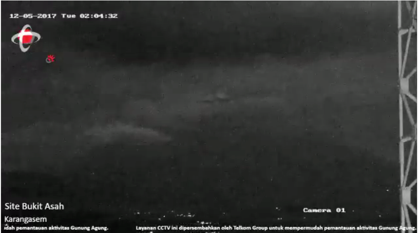
(also a test if I can embed a photograph.)
GL Edit: It worked. Since it was a direct link to a file delimeted as a png, the IMG tags were not needed, I removed the extra tags that WP didn’t need.
Just after 0400 (Bali time) the seismogram had a cluster of those very sharp spikes which, I believe, are the sgnature of lightning strikes, which ties in with what you said
Great feature on ‘Dr Atl’ and the paintings of the pop-up Mexican volcano on BBC 4 right now – “The Art That Made Mexico: Paradise, Power and Prayers “
Nothing on the seismogram since 04:30 Bali time.
https://magma.vsi.esdm.go.id/live/seismogram/
So frustrating isn’t it! A couple of times it has coincided with high tremor levels. That may or may not be a coincidence.
On the right side of spectogram, there is vertical line, which is simplified seismogram, and it is working.
Thanks for that reminder Marek! I know this but I am getting forgetful and don’t look for it! 🙁
Plume looking much more visible than for several days. More pressure than yesterday, but not exactly pumping. My guess is it’s mostly steam with maybe a little ash.
Either a strong wind, or something else is shaking the gantry.
Did I just say that?
At 8.55.50 local time, plume grows vertically with greater intensity… Explosion in the crater?
More obvious when seen from the Rendang cam. Plume suddenly grows to (my guess )1500 metres above the crater.
VAAC Darwin has not taken notice of it.
Would they take notice of a moderately sized steam plume ?
Anything that can be detrimental to flight, they would be all over it.
Well, there was, in this case, absolutely no doubt that it was there. I witnessed it clearly rising way above the rest of the local cloud. It dissipated pretty quickly and was followed a few minutes later by another…. By which time it was very late here in the UK, so I went to bed.
I’m pretty sure it was steam, or mostly steam.
From Rendang this was clearly visible as a fairly solid column of steam., rising much higher than the rest of the cloud in the shot.

Link to the PVMBG image that seems to show it best.
Fabulous reading ,a true gentleman posting this.
Geologist here with travel plans throughout Indonesia for the second half of December, including a flight through Bali next week and a full week in Bali at the end of December (about 80km south from Agung so should be safe-ish). Travel insurance wont cover any flight cancellations related to the volcano. Wish me luck!!…
Hoping that even in the event of more eruptions, the southerly winds and rains typical for this time of year will hold up and keep the ash clear of the airport.
Enjoy! Keep us posted on news if you can.
Regarding other sources for seismic noise. Interesting BBC report…
How ‘bomb cyclones’ can let us peer deep inside the Earth – http://www.bbc.com/future/story/20171204-how-bomb-cyclones-can-let-us-peer-deep-inside-the-earth
Looks like something’s happening at 14:00.
https://magma.vsi.esdm.go.id/live/seismogram/
This cam looks like heavy rain.
Another of these high amplitude tremor like events. Heavy rainfall with water flows and lahars? Real tremor signal from rising lava? Info from more seismo stations around the mountain needed to find out.
Try this link, posted by Frances earlier.
http://agungcctv.brunswicktech.com.au/sgram
Thanks Neil and Frances. Useful site.
Anyone have a quick note on reading the graph? It looks like lite colors indicate energy at that frequency, which is fine, but what does the seismograph like plot down the right side indicate?
My guess is real volcanic tremor..
Not based on any real knowledge, besides people gathering in front of the Rendang camera, and looking in the direction of the volcano when the “tremor” started..
If you look back at the Rendang video, at about 14.45, just after the tremor starts..
Wind.
It’s not wind – wind speed is only a few km/h at present.
It’s volcanic tremor.
dont know how much it differs from the summit, but at Redang it looks like almost no wind.
Wind speed even at summit altitude is about 5km/h – so that is NOT wind.
There’s only ever been a loose correlation between that high amplitude tremor and visible/surface activity.
Anyway, those links provided above are great. SSAM shows blobs of low frequency tremor below 3Hz increasing over the past few days – as the higher frequency tremor has subsided. It’s changed. What that means, I’ll leave to experts. My guess, activity down deep has increased and this isn’t over – it may have hardly started.
Starting almost the same time as last time (than it was 2:20pm, now 2:40 or so). I looked back at three from last week : they started 2:40pm, 1:10pm, and 2:20pm. If it is volcanic, the volcano is doing afternoon shifts only (or it carries a pretty good clock). Almost makes you wonder whether it is human. But weather-related is most likely.
I don’t think I’ve ever seen it at night, that’s for sure.And the more that happens the more it tends to suggest that it is related to something that only happens by day.
It’s very odd. I agree it correlates with time of day – looked back on some past images. It’s not wind. It doesn’t look like what I’d expect from traffic. after about 3 1/2 hours, and it tapers off.
https://www.jawapos.com/radarbali/read/2017/12/04/31346/aktivitas-galian-c-berjalan-normal-bupati-mas-demi-pembangunan-bali
https://www.jawapos.com/baliexpress/read/2017/12/04/31092/depo-galian-c-beroperasi-dan-dijaga-polisi-di-jalur-evakuasi
I searched back the seismograph data (http://agungcctv.brunswicktech.com.au/tmks/review)
These are the periods I found the tremor discussed, local time
29-11 14.21-19.00
30-11 ? – plm 9.30
01-12 16.42-17.47
02-12 14.03-16.15
03-12 15.30-17.45 (weak)
04-12 no tremor
05-12 14.20-17.50
Could be very well rainshowers as Albert wrote, isn’t there any radar available, to check?
And torrential rains can trigger lahars down the mountain?
Wish the clouds would go away. Seismogram tempts me to watch, but alas I must to get some sleep. I’ll check later to see all your opinions. G’nite 🙂
Info Gempa Mag:3.0 SR, 05-Dec-17 15:57:29 WIB, Lok:8.85 LS,115.02 BT (29 km BaratDaya DENPASAR-BALI), Kedlmn:13 Km, drskan di Kuta dan Nusa dua III MMI (II SIG BMKG) ::BMKG
https://twitter.com/Sutopo_BNPB/status/937997030437167104
If it was the sand and gravel production, would that impact on ALL the sensors? And why would the activity fade off over 30-60 minutes? Surely it would all shut down within one or two minutes?
TRAVELING TIME LAHAR
Noteworthy Traveling Time Flow Begar begins from the observation of lava flow signal at 15.00 WITA 05 December 2017 upstream by SRR Radio Relay Station to Tukad Bridge is 30-40 minutes for this small lava flow … It is said small lava flow because it is still mixed water dust and volcanic ash, there are no rocks or big rocks that come flowing …
This is useful for the preparedness of people living near the river …(Lesto Prabhancana Lesto ) facebook
Kelud seismograms before the eruption in 2014

Note that every line means 4 minutes.
About 200 low frequency non harmonic quakes had appeared day before the eruption.
Comparing to Agung seismogram ( I ignore lahar tremor), seem that Agung is about week or two, before the plinian eruption. About 40 LF eartquakes noted in last day.
Intriguing sequence of data.
If the frequency of quakes was more or less smoothly progressive over days and weeks, and Kelud was closely comparable to Agung, this would be a great predictor.
A question. I don’t get the 4 minute line length of the graphs at all, because that would make the quake signatures only seconds in duration. Is that right?
Steve G.
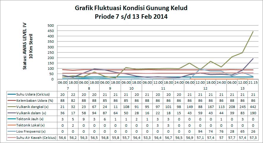
Yes, you are right about duration. I think it also means, that these quakes are very small compared to larger Agung quakes and there are a lot of tectonic quakes between them.
(picture from volcano discovert)
It differ from Agung, where volcanic tectonic earthquakes appeared earlier in distinct episode.
Is there a glow and a plume from the crater now ?
It was stronger at 20:05 .
I see it also.
Yes, definite glow, and at times I believe I’ve seen it shining on a plume… I haven’t seen enough to say how big the plume might be. It would really help if the weather changed !
I’ve just had a look at weather radar for the area, and it looks like it may clear up over the next couple of hours.
But you can never be sure with mountains.
https://www.accuweather.com/en/id/denpasar/202196/satellite/202196
Visible light rays from lava that bounced to smoke at the peak crater of Mount Agung on 5/12/2017 at 20.30 Wita. PVMBG continues to monitor the volcanic activity of Mount Agung. Caution Status (level 4). https://twitter.com/Sutopo_BNPB/status/938034971582664706
Still visible.
I can’t quite figure out the relative locations of the Desa Rendang and Bukit Asah cams, but couldn’t we just be seeing moonshine through clouds at the summit? The moon is almost full. Surely, if there was activity at the crater we would see something on the seismograph?
Okay, there is definitely incandescence at the summit because the moon is now visible separately from the Rendang location.
Bukit Asah is South South East of the crater, and Rendang is very roughly 90 degrees (actually a bit less than that) around to the West of the crater.
On the Desa Rendang cam you can at the moment see the silhouette of the mountain and the plume thanks to the bright full moon. Part of the plume is also lit up from below by the glow of the lava.
And a screenshot:
Just as confirmation it is definitely a lava dome in Agung
How do we know this?
By the way, it is amazing how many lights are on up to 1/3 of the way up the volcano. Hopefully, those are not people, but streetlights or lights left on in homes after the occupants left.
https://www.volcanodiscovery.com/agung/news/66391/Agung-volcano-Bali-Indonesia-activity-update-new-lava-dome-growing-in-summit-crater.html
:::: MAGMA-VAR :::: *
* GUNUNGAPI ACTIVITY REPORT *
* OBSERVATION PERIOD *
05-12-2017 18: 00-24: 00 WITA
*VOLCANO*
Agung (3142 mdpl),
Karangasem,
Bali
* METEOROLOGY *
The weather was clear, cloudy, and overcast. The wind was blowing weakly eastward. Air temperature 22-25 ° C and air humidity 83-87%.
*VISUAL*
● Mount clear until fog 0-III. Medium pressure crater smoke is observed in white with moderate intensity and height 1500-2000 m above the top of the crater.
● Observed by the fire at the top of Mount Agung.
* REQUIREMENTS *
■ * Blowing *
(Amount: 5, Amplitude: 3-10 mm, Duration: 25-45 seconds)
■ * Harmonic Tremor *
(Amount: 1, Amplitude: 12 mm, Duration: 118 seconds)
■ * Low Frequency *
(Amount: 9, Amplitude: 4-16 mm, Duration: 40-59 sec)
■ * Shallow Volcanic *
(Amount: 6, Amplitude: 3-5 mm, Duration: 10-24 sec)
* Continuous Tremor (Microtremor) * recorded with amplitude 1-4 mm (dominant 1 mm)
* OTHER DESCRIPTION *
Nil
*CONCLUSION*
Activity Level G. Supreme Level IV (Awas)
*RECOMMENDATION*
Communities around G. Agung and climbers / visitors / tourists not to be on, not climbing and not doing any activity in the Hazard Zone Zone within the G. Agung crater area and in all areas within 8 km of G. Agung crater and plus the sectoral extension to the North-East and Southeast-South-Southwest as far as 10 km from the crater of G. Agung. Estimated Zone Dangers are dynamic and continually evaluated and can be changed at any time following the most recent / recent G. Supreme observational data.
* REPORTING REPORT *
Wahyu Ardi Setiawan
*DATA SOURCE*
KESDM, Geological Agency, PVMBG
Gunung Agung Observation Post
https://magma.vsi.esdm.go.id/
The Ash cloud looks even higher now .
Just to remind folks this camera is prone to the “smoker”. Someone pops out onto the balcony (just below this camera) and smokes, from time to time. Gives weird effects of whirling haze and ash particles right in front of the camera! I do wish they’d move along the balcony a bit when they choose to smoke.
Good morning from Alaska, this is a time test check….
spider web??
https://www.huffingtonpost.com/entry/in-bali-science-collides-with-money-politics_us_5a236d09e4b05072e8b569e9
At about 1:04 am local time there was an increase in activity. Maybe a small explosive event.
Mac
And a glow from 1:12 to 1:25 after that. So that event maybe is related to bubbles formation inside the magma, and we have to wait a while, when it come out on the surface?
Big glow at the crater right now (18:01 UTC)
Hoping this picture posts as a picture not a link:
https://imgur.com/a/wzzpY
TINGKATKAN KEWASPADAAN
Banyak laporan suara gemuruh dan suara mirip kompor gas malam ini
INDIKASI TEKANAN DAN AKTIFITAS MENINGKAT
INCREASE KEWASPADAAN A lot of reports of thunderous sounds and sounds like gas stoves tonight INDICATED PRESSURE AND ACTIVITY INCREASE
Gogle translate-gas stoves, that totally freaks me out.