
Gunung Agung during the eruption. Photo by Emilio Kuzma-Floyd (http://www.eyesofanomad.com/)
Most people have by now noticed that Gunung Agung has stopped erupting. And to understand why that has happened, and what will happen soon, we need to look at what happened during the eruption. We also need to look at what is currently happening.
When a volcano is showing no visible signs of activity, we have to turn to instrumentation to understand what is going on where we can’t see anything.
But, before that, we must look at what a volcano is at its most fundamental level.
Volcanoes as energy transfer systems

Tempel covered in ash. Photograph by Tangkaswara TP.
Most people tend to think of volcanoes as outlets of magma, but the magma is just a way of transporting energy. In mantle plume volcanoes this energy has travelled from the bowels of Earth, at spread centre volcanoes the energy is transferred from the mantle, and in subduction volcanoes that energy is caused mainly by friction from the subducting slab grinding against the thicker upper crustal part.
Now, many will say that it is lava that is squirting out. Well, yes it is lava that is squirting out, but the greatest difference between lava and your average garden rock is heat. And heat is a form of energy.
So, any volcano will be a basic energy transfer system. But, the magma type does have effects of how the volcano will erupt. The energy transfer affects when, size and type of eruption in combination with the type of magma involved and the involved volatiles residing in the magma.
These combinations are affecting the behaviour of every single volcano on the planet. Sometimes two close by volcanoes erupt in completely different patterns and ways due to this.
Gunung Agung as an energy transfer system

Current tremor chart. Image from Badan Geologi.
Agung is a subduction volcano of a fairly ordinary type. At depth magma accumulates at a point called the accretion zone, it is where melted subducted rock pools complete with its molecular components and energy in the form of heat.
This pool of magma will take on characteristics of the subducting plate. If it is water rich the magma will be water rich, if it is rich in metals and sulphuric compounds the ensuing magma will also be that.
Due to the heat the melt will weigh less than the rock above, so it will be buoyant and try to migrate upwards like a hot-air balloon.

Heavy volcanic tremor episode. Image from Badan Geologi.
In the end that balloon of hot magma will enter the magma chamber of Gunung Agung and it will start to expand, both from the heat increase and the volume of the fresh magma. There will also be considerable exsolution of volatiles as the magma nears the top of the magmatic system.
In the case of Agung the magma is rich in silicates, water and sulphur. The magma at Agung is of a highly silicic type called andesite. That means that the magma is sticky and prone to being able to contain substantial amounts of water and gas before fracturing. That makes it potentially very explosive as it comes out.
What has happened at Agung?
Before any visible signs happened at Agung, scientists started to pick up small earthquakes and see a slight inflation of the volcano indicating that new magma was entering the system. In this case they knew that Agung was reactivating about a year prior to the current activity.
This made it possible to increase the monitoring and start to produce more detailed evacuation maps. At the same time local authorities started to consult with the scientists to prepare for what would potentially come. As activity increased over time these plans became more detailed and the local population was informed about evacuation plans.
As things progressed even further an exclusion zone was put into place and people where evacuated from the mountain.
After that the volcano started doing what volcanoes do best, and that is erupting. The opening stage was a hydrothermally driven phreatic detonation that lasted for a short while. After that the volcano returned to a more restful look.

Sulphur cloud caused by Gunung Agung. Image by JPL/NASA.
A phreatic detonation is when increased heat from below rapidly heats water inside the mountain causing steam explosions. This often clears out an upper conduit through the mountain that the magma can follow at a later stage.
During this interlude the seismic signals and inflation continued and increased until the mountain finally erupted by ejecting fine grained tephra and prodigious amounts of sulphurous gases. This eruption phase has been calculated to have been a small VEI-3 with 0.012km3 of ejecta.
Here comes what is rather unusual. A second vent opened up after a couple of days, and pure steam came gushing out next to the vent ejecting the tephra. This can be seen on the video above. Normally all water has been boiled off from a volcanic system prior to the magmatic phase, but here there must have been a rather powerful aquifer or water body next to the volcano that took to long time to heat up to an explosive level.
In the end the shear volume of water quenched the andesite in the conduit and a glassy plug formed that corked up the eruption completely. This is among other things measurable on sulphur gas output that has diminished quite a lot from during the eruption phase.
What is happening now?

Daily life near a volcano. School children going to school outside the exclusion zone.
After the eruption there have been almost daily episodes of violent tremor caused by ever more increasing pressure inside the volcano. This pressure is caused by the energy in the form of heat causing the old magma in the system to expand further as it heats up, and it is also caused by more magma entering the system.
This tremor has been very large compared to other similar systems, so we do know that the rate of pressure increase is high. There has been a lot of volcanic type earthquakes also, and that is another sign of increasing pressure.
What will happen?

Evacuation being enforced by the Indonesian authorities. Photograph by Humas Basarna.
The shear intensity and duration of the tremor episodes tell a story that it is in the long run impossible for the quenched plug to hold back the lava. It also tells that the plug is very solid and sitting very firmly in the barrel of Agung.
This is potentially bad news. Either the plug will start to slide up and form a dome or a spine before being blown away. Or, the plug is so firm that it will shatter inside the conduit and come out explosively during an explosive phase.
And the general rule is that the longer time we must wait, the larger the ensuing eruption will be.
Currently the seismic signals have quietened down, this is normal prior to an eruptive phase. But, it is also possible that we will see several more phases of intensified seismic unrest prior to the next eruption.
If I was to hazard a guess here, it would be that we will see a more intense eruptive phase at any time, ranging from in a few hours to a few weeks. But, my opinion may change as we get more data.
One thing I am thankful for is that it is the Indonesian authorities that oversee this. The local scientists and authorities are very good at these things. I would even go so far as to say that they are the best in the field currently.
CARL REHNBERG
EDIT: Correctly attributing the photographer of the featured image, thank you to Emilio Kuzma-Floyd for pointing out our oversight, and providing this GIF for usage


So…basing this on absolutely nothing other than the reported presence of a growing lava dome in the crater, I am guessing that the activity we are seeing (glows, etc…) is occurring when the dome has a landslide or other event causing the “crust” to break open, exposing the still incandescent lava within. Then the glow fades as the “crust” cools with exposure to air.
That fits.
http://bali.tribunnews.com/2017/12/05/breaking-news-gunung-agung-semburkan-asap-setinggi-2000-meter-di-atas-kawah
Groan…. even their journalists are twits.
“Asap” → smoke.
Smoke particles won’t kill a turbine engine. Ash is different. Ash is pulverized rock, typically high in silica. In other words, crushed glass. It scours surfaces and adheres to turbine blades and clogs fuel systems.
Perhaps you are confusing the poor translation of Indonesian as poor journalism? I don’t know but having seen Google Icelandic translation referring to ‘boilers’ I would most certainly not blame Balinese Journalists when it could be a translation problem.
I think this is a typical “lost in translation” case.
Smoke in English is defined as: “… the vapour or volatile matter which escapes from a burning substance during combustion.”
In German (as example) the direct translation “Rauch” is defined as any mixture of solids in gas, no matter whether product of a combustion or not.
Maybe this is similar in Indonesian?
In any event, your average journalist will be puzzled that ‘smoke’ is inadmissible while volcanologists themselves still happily use the word ‘ash’ which likewise implies combustion
Another “BUM” at 3:12
small edit to the main post to include proper attribution of the first image, thank you to the photographer for pointing out our error and giving us a .gif for our viewing pleasure.
Thank You Nomad, I meant to check out your web page the other day, it is a fantastic picture.
Tuesday
05.12.2017 19:35:49 64.012 -16.627 0.5 km 2.3 99.0 2.7 km E of Hvannadalshnjúku
I am a little surprised it has been given a VEI-3 but I guess it is a small VEI-3. This scenario with the possible ground water interaction is troubling, and a plugged vent to boot. Water and magma don’t mix.
Yep, definitely in the VEI-3 realm. But I don’t think it is anywhere near over.
Thanks Lurk. I love charts, plots and graphs. Looking at the seismo there are plenty of small quakes on the right side. I wonder if the chamber is pressurizing at a fairly steady rate and when it gets to a point there is crack. The time interval is fairly consistent but not close to exact.
https://magma.vsi.esdm.go.id/live/seismogram/
https://www.youtube.com/watch?v=uWOfumfi4LA
This is the second ‘blast’ from Agung this early morning in Bali! Not sure what is happening currently but something surely is!
http://agungcctv.brunswicktech.com.au/cctv
Look back at the cam images, this is the second time the plume has blasted high!
I expect that by the time anyone notices this comment that these strange ‘eruptive phases’ may be over but believe me please, something is making Agung’s plume explode in regular intervals. Sadly I don’t know how to post the images.
It seems I am talking to myself here but I am wondering if degassing could cause this sudden eruption of what appear to be steam and most likely gasses too?
OKAY! , obviously nobody here. So to explain what was happening in case it is all over before anyone arrives and observes it, (So frustrating! Where are you all? ) The plume was going from it’s normal (currently normal) small amount of steam to a plume at least the height of the mountain or perhaps higher. I am not the best observer or estimator of plume height, but it was HUGE, and happened at least twice as I was observing it over a period of one hour. So sadly, as none of you observed it it shall perhaps remain a mystery as I don’t have the knowledge to explain what was happening.
So now I am off to bed as I hate talking to myself, so goodnight all. 🙂 🙂 🙂
Checked the web cam, and nothing but a tiny bit of ‘smoke’ and a glorious calm morning – then right before my eyes there was a bit of a parp a second ago
White smoke with moderate intensity out of the crater of Mount Agung. Caution Status. Radius 8-10 km from the top of the crater is a dangerous zone. Blast of gray white smoke accompanied by a roar from the summit crater of Mount Agung on 6/12/2017 morning. Continuous tremor amplitude 1-2 mm. Caution Status (level 4). Within a radius of 8-10 km there should be no community activity.
I saw something right before 7 am, had to let dogs out and now off to feed horses, but something is happening.
There is a lava dome which restrain degassing. But when more of gases will come, a pressure can lift part of dome and release the gasses in “explode” mode.
Thanks Frances, good someone is a wake and keep track. Early morning here and first thing I looked up was your report.
If I had to venture a guess, I’d say it may be related to the landslides on the lava dome I speculated about earlier.
I think, that it is something like semeru lava dome but in 10 time greater scale and it don’t need a landslides. This is andesitic magma.
Magma :::: *
* Gunungapi activity report *
* period of observation *
06-12-2017 00: 00-06: 00 com
* Gunungapi *
Agung (3142 m),
Karangasem,
Bali
* Weather *
It is cloudy and cloudy. The wind blows to the east. Air temperature 21-22 ° C and air humidity 86-87%.
* Visual *
● The mountain is clear until the fog crater 0-II, until observed, is white with a fine intensity to medium and high 1000-2000 m above the crater.
● -on the night he observed fire of light,
– smoke to the east ..
* Kegempaan *
* Low frequency *
(total: 8, range: 4-20 mm, duration: 40-115 seconds)
* Shallow volcanic waters *
(total: 5, range: 2-5 mm, duration: 10-24 seconds)
* * Volcanic Volcanic *
(total: 3, range: 3-17 mm, s-P: 1-2 seconds, duration: 9-42 seconds)
* other description *
A tremor in 1 MM, dominant 1 MM.
* Conclusion *
The activity level of g. Agung IV (Beware)
* recommendation *
People around the g. Large and mountaineers / non-travelers, do not climb and do no activity in the danger zone is within the area of the crater g. High and across the area within a radius of 8 km from the crater g. Agung and added to the expansion of the north-north-east and south-west-southwest divide, 10 km from the crater g. – Great. – Great. An estimated danger zone is dynamic and continues to be assessed and can be altered during the development of g surveillance data. The most recent / most recent.
* Compiler report *
Nurul Husaeni, a. Doctor.
* Data source *
Kesdm, geological organism, pvmbg
Great observation gunungapi
https://magma.vsi.esdm.go.id/
http://www.nusabali.com/berita/21997/ini-dia-dua-skenario-erupsi-gunung-agung#.WidDoK2hRPA.facebook
Not sure what the seismic signals have telling us for the last couple of hours. Totally unlike anything we’ve seen so far…unless it’s a data/telemetry problem? The short-period pulsations are very regular ATTM.

I noticed that too… If you look at the spectrogram you’ll see a signal at 6.5 Hz which completely drowns out everything else, due to the automatic gain correction effect.
My bet is on human activity, perhaps some kind of machinery that has been started this morning.
Might be wind too. If you look at the flag at the Resa Dengang location you’ll notice that the wind speed has increased since yesterday. Perhaps the frequency of the strong signals in the spectrogram correlates with wind speed?
Also faintly visible on the spectrogram is the first harmonic of the 6.5 Hz signal. 6.5 / 13 Hz seems a bit high for harmonic tremor, no?
And now the strong signal in the spectrogram disappeared and the flag looks calmer. Another piece of evidence for wind correlation.
Yes. It doesn’t look like any tremor I’ve seen so far. If you look real close, the periodicity isn’t EXACTLY regular as if a machine was nearby. IMHO, there are natural forces at play.
Replying to myself again since I don’t know how to edit my comments…
In case someone reads this later, this is what I mean. I circled the signal and the first harmonic in the spectrogram.
Certainly artificial. Note the starting time of 8:30am. The frequency jumps seem due to a changing load. I think they may have done maintenance on the sand mining.
From just after 8:30am to around 9:45am the conveyor belt at the sand mines were clearly running. Check the seiso to see that.
http://agungcctv.brunswicktech.com.au/tmks
You can clearly see the rhythmic signal of it on there. Apparently the sand mines are STILL working despite being within the danger zone. I just hope they are paying their workers danger money! Maybe they have been given permission to get out the remaining processed sand and gravel? Maybe they are doing it without permission, hence that signal being mainly during the night?
Your right. The 6.5 Hz is what the drumplot is showing. Not sure it’s human caused, though. But, with the “lull” in activity, maybe some folks are being overly complacent? Sure hope not. Carl’s analysis is spot on, IMHO.
A closer look at the data suggests the pulsations are approx. 200mS, or about 0.20 Hz. Given the low frequency, the only thing I can think of is an oscillation/tremor resulting from freely-flowing magma?
Correction: That’s ~5 Hz, not 0.20 Hz. Pardon my math-fart.
Another thing about harmonic tremor caused by moving magma: if the harmonics were strong enough, you’d expect to see sharp vertical bands in the spectrogram. And the spacing between the bands would be fairly small because the fundamental frequency caused by moving magma is low. In addition to that I would expect some kind of glissando effect, which would cause the bands to bend. Especially close to an eruption. See this article for more info: https://pnsn.org/blog/2011/12/14/why-does-a-volcano-scream
The strong signals in the spectrogram shows only weak vertical bands which are widely spaced and there is essentially no glissando effect.
Also, about the glissando close to an eruption: this would probably be a continuous frequency bend. You would not expect the bands to jump in a “stepped” fashion (like in a piano glissando), but rather more like a trombone or a electric guitar bend. Cf. the whistling sound of a kettle of boiling water. As the temperature and pressure inside the kettle increases, the pitch of the whistle goes up. To add to the confusion, in musical terminology, this effect is sometimes also called portamento or legato. Again, the important distinction is whether frequency changes are discrete or continuous. For a natural phenomenon like moving magma I would expect continuous rather than stepped changes in fundamental frequency.
I couldn’t help myself…
Here is an spectrogram image that illustrates the difference between a continuous bend and stepped glissando type effect. The bend is just short of a semitone (because the strings on my acoustic guitar are very stiff and my fingers are too weak…). The glissando effect covers about five or six semis.
The left side of the spectrogram covers the continuous bend. This is what I would expect volcanic tremor to look like before an eruption, or for that matter the whistle of a kettle. With the difference that the bending range would be much more extreme, perhaps covering a couple of octaves instead of barely a semitone.
On the right side of the plot you can clearly see the harmonics jumping in a stepped fashion.
NB. to further add to all the confusion, frequency is on the vertical axis on my plot, while you’ll find the frequency on the horizontal axis on the spectrogram plot from Bali. 🙂
Thanks, i teresting. Now it will be hard not starring at the spectrogram 😁
Post-post scriptum:
The spectrogram I posted above is of a steel stringed acoustic guitar. Because of conservation of energy, once plucked the intensity of the vibrations of a guitar string tends to decay in time. Essentially, energy in the form of string vibrations is lost to the surrounding environment (if this did not occur we wouldn’t hear the instrument!).
I would not expect this from harmonic tremor generated by moving magma. A volcano is acoustically much more like a wind instrument, where energy is constantly being supplied.
What all this means is that volcanic tremor would not display the smearing effect in time which is evident in the above plot, as the harmonic bands get “thinner” horizontally.
So use a bottleneck and a sustain… Big Muff style ! 😀
Good to see someone else speaking my language.
BTW, I have regularly seen that big signal when the flag is utterly motionless, so I don’t think you can use that as evidence to tie the noise to wind.
Rainfall might seem a better fit, if it wasn’t for the apparently regular pattern of i.
It’s not low enough for my liking, I’m more partial to something around the 36.7 Hz mark on occasions with 41.2 Hz for everything else…
I usually put a gate on anything below 50Hz….. except for one or two of my favourite toys 😀
Both cams frozen, but if the Rendang image is anything to go by, there’s nothing to see except torrential rain.
I hasten to add, four strings an absolute maximum.
Hopefully that’s not what’s happening inside the mountain.
https://www.youtube.com/watch?v=XY2VgvOk5Zo
Inspite of how it looks like, we’re not really looking for explosions and fire… (unless it’s safely contained, visually attractive, and causes no harm to the surroundings, ie nice natural spectacle)
No four strings is truly, all any half decent musician needs ! I’m happy with just the four… Although my usual territory is one or two skins… not strings.
(Bass, baritone uke, and mainly percussion… NOT kit !)
Alcide Cloridrix….
Looks like we have bass, guitar and percussion sorted.
We just need vocals…. for which I could always recruit my daughter. She’s….. A bit good.
Indulge me.
This is her just after her 13th birthday, jamming with a professional guitarist friend of mine… He wouldn’t even let me play the kit on this ! 🙁
https://soundcloud.com/user-879188213/wayfaring-stranger-rock-version
thanks emanuel for the waveform stuff, and then also thanks to neil for the soundcloud link -props – you all need to start touring with some volcano rock 🙂
Many thanks to Emanuel and Frances for the clarification(s) and tutorial!!
Your analogy to a wind instrument is very interesting, as I had considered the same thing (but in a more pedestrian manner), but the regular beats at 200mS at night was throwing me (until Frances mentioned the sand operations).
I wonder if you could tell if the orifice size of the magma conduit was changing based on the “pitch” of the signal? i.e. smaller orifice=higher frequency, higher velocity?
Thanks everyone for your comments! I’m not a professional musician but one of my (many) special interests is in acoustics, signal processing, and the related physics and mathematics. These are merely my amateur musings.
In answer to Craig Heden about the size of the magma conduit and its relation to the pitch: I think the pitch of the tremor has more to do with the number of rock fractures/slips per unit of time than the geometry of the volcano per se, because the geometry is relatively static in comparison. As I understand it, the number of “drums” per second increases quite rapidly (at a rate of, say, a couple of octaves over just 10 minutes) just before an eruption. That said, the slowly changing spatial dimensions will definitely determine where the resonance frequencies are. Much like how the body of a guitar or a violin affects the tone of the instrument.
This cam is working.
Thanks Janet. I didn’t know about this one.
And now we’re back into high-tremor territory, slowly tapering offas it did, did and did again……..
Yet another pulse of dome growth???
No expert here, but….
Let’s just expose an hypothetical thought for a moment. I may (certainly) be flat out wrong, but whatever makes you think, is good.
One of us there, reminded that Agung underwent an important inflation event in 2006-2009 that resulted in nothing. Probably some recharge at depth, but not enough energy to make it to the surface. But that leaves a lot of magma festering and simmering away into the deep reaches of the system, slowly loosing gas and heat as time passes, until….
Some 10-years later,another magma injection event takes place. This time, it’s more than what the structure of the volcano can take, and rock starts breaking. Hence the seismic crisis of mid October.
This also reprimes the stale magma from 2006 (and preceding)events, making it energetic enough to start ascending at a very slow pace, bit by bit since it just had the most bare minimum on energy to do it.
Upon reaching contact with the surface aquifers, phreatic to phreatomagmatic explosions occur, and the only gas providing the explosivity is the boiled water from the hydrothermals.
When the white vent exhausting steam popped open, it provided an easier path for this pressure to exit, instead of having to blast through extremely-stale very viscous magma, it had free-way to the surface, so ash venting stopped very quickly.
Now we’re in a dome growth phase (think Soufriere 1971, or Kelud 2007).
Every episode of saturating tremor may be the dome growing a bit more, once pressure from below is enough to start things moving. The near-coincidence in time may be due to tidal effects.
Magma is bizarre stuff, it’s non newtonian, but works like reverse oobleck. By itself it’s hard and pasty, but when you give it the right push, it becomes free-flowing. Like ketchup.
So nothing moves as the plug of pasty lava sits in the throat of the volcano, letting pressure rise from below. Once pressure reaches critical level, or an external force (tidal deformation, here it comes), the magma plug suddenly starts moving up again in one go (this explains the sharp onset), pressures relieves slowly and magma starts solidifying again, hence the slow taper off.
The question is… How long will it last?
It may go Sinabung, and spill over the crater edge making for a long run of pyroclastic flow actiity.
Or once stale magma will be exhausted, it will start to tap into the fresh, hot, gassy magma from october that’s providing the driving force, and things will get ugly in a hurry.
Think the 2007-2014 eruption cycles at Kelud…. It may do both styles right next to each other, or it may pause for weeks/months between making a dome and going kablam…..
Based on 1963 precedent, it seems usually not want to take a break.
sounds sort of plausible to my inexpert ear 🙂
Interesting scenario. Let us see what will come next!
Neil Law … Pardon me for the off-topic, since I couldn’t reply under your post…. This is lovely stuff. Like it.
On the other hand, speaking of rock music, one of our French veterans just passed away. Rest in peace Johnny.
https://www.lci.fr/people/en-direct-video-johnny-hallyday-mort-notre-douleur-est-immense-declarent-ses-enfants-david-et-laura-smet-2072601.html
Johnny Hallyday… Iconic !
Volcanic music was something suggested on a previous post when I likened some Seismic signatures to certain transients I’m familiar with, working with recording software.
And at some point I will indeed look into a possible project based on the concept.
As for my daughter, she’s 17 next month, and already way beyond me as a musician. Watch that space… She’s caught the eye of a couple of music industry big players … And before anyone wonders… she’s got a big, mean old man making sure only the good people get to talk business to her !
This is a very good link to get info and updates on what is happening in the Agung area.
https://twitter.com/@Sutopo_BNPB
I have seen him in uniform at press conferences, so he does seem to have the official news of what is going on.
Thanks Frances
At least you know someone else is reading your posts this time 🙂
I was doing a piece of work last night and didn’t get to look at any screens.
🙂
Lovely sunsets on this cam now.
http://agungcctv.brunswicktech.com.au/cctv
* :::: MAGMA-VAR :::: *
* GUNUNGAPI ACTIVITY REPORT *
* OBSERVATION PERIOD *
06-12-2017 12:00 to 18:00 WITA
*VOLCANO*
Agung (3142 mdpl),
Karangasem,
Bali
* METEOROLOGY *
The weather was overcast and rainy. The wind was blowing weakly westward. Air temperature 23-28 ° C and air humidity 71-90%. Rainfall volume is not recorded.
*VISUAL*
● Mount clear until fog 0-III. Smoke from mild to moderate pressure crater is observed in white and gray with a thin and high intensity 1000-1500 m above the top of the crater.
* REQUIREMENTS *
■ * Blowing *
(Amount: 1, Amplitude: 6 mm, Duration: 35 seconds)
■ * Low Frequency *
(Amount: 12, Amplitude: 4-23 mm, Duration: 40-65 seconds)
■ * Shallow Volcanic *
(Amount: 2, Amplitude: 8-18 mm, Duration: 15-20 seconds)
■ * Local Tectonics *
(Amount: 1, Amplitude: 24 mm, S-P: 4 seconds, Duration: 130 seconds)
* Continuous Tremor (Microtremor) * recorded with amplitude 1-24 mm (dominant 3 mm)
* OTHER DESCRIPTION *
Recorded Tremor Overscale starting at 14: 46-15: 06 Wita.
Recorded Tremor enlarged with amplitude 3-24 mm starting at 14:40 to 17:00 pm.
*CONCLUSION*
Activity Level G. Supreme Level IV (Awas)
*RECOMMENDATION*
Communities around G. Agung and climbers / visitors / tourists not to be on, not climbing and not doing any activity in the Hazard Zone Zone within the G. Agung crater area and in all areas within 8 km of G. Agung crater and plus the sectoral extension to the North-East and Southeast-South-Southwest as far as 10 km from the crater of G. Agung. Estimated Zone Dangers are dynamic and continually evaluated and can be changed at any time following the most recent / recent G. Supreme observational data.
* REPORTING REPORT *
Wahyu Ardi Setiawan
*DATA SOURCE*
KESDM, Geological Agency, PVMBG
Gunung Agung Observation Post
Picked up a link posted by Pyter,
http://www.nusabali.com/berita/21997/ini-dia-dua-skenario-erupsi-gunung-agung#.WidDoK2hRPA.facebook
Interview with mr. Sutopo published 6th of December.
Short, short version, translated:
Outcome of analyses of the monitoring data, there are two scenarios. First is a further decrease of activity of the volcano. Second is a period of rest due of a blockage, and finally a new, strong outburst. The longer the rest, the larger the outburst.
The blockage (second scenario) may be supported by the fact there has been a sudden decrease of measured SO2 emission (26-29 dec 5000-10000 tons a day, 30 nov only about 1000 – 2000 tons). The growth of the lava level in the crater has been decreased likewise.
Giggle makes a mess of the last part of the article, maybe someone can translate the last three paragraphs. Could be interesting. 🙂
I can’t make heads or tails of it either, I now only know that they kiss in the disaster prone area.
Lol. Could be helpful at some point… 😄
http://agungcctv.brunswicktech.com.au/cctv – Red dot ?
Changes between green/red over various images regardless of cloud cover so looks to me as if it is a camera flaw (assuming it is not a very bright traffic light!)
🙂 Thank you ! – https://magma.vsi.esdm.go.id/live/seismogram/
I agree. That looks like a stuck pixel to me. One way to find stuck pixels like these is to combine several images taken by the same, fixed camera at different moments in time. Sensor flaws like these will stick out like a sore thumb in the resulting average image.
First night lahar is begining.
Wondering if this is possibly true tremor? The off scale events that we have suspected of being lahars, have, if my dodgy memory serves – reached peak noise by 5-10 min from onset before decaying, kind of what you would expect if a surge front with debris is approaching and passes at speed. The current signal has shown a steady and gradually increased over a 30min period.
I think it depend on how the rain started, so every lahar/cold lava can be different.
PVMBG now insert this off scale events into * OTHER DESCRIPTION * 🙂
Look on Pyter post: http://www.volcanocafe.org/gunung-agung-and-the-potential-future/comment-page-2/#comment-20418
Just found a time-lapse on Youtube of the explosive plumes I was seeing last night.
Ash is detected by NOAA satelite.
Hi Marek, do you have a link for that please?
https://volcano.ssec.wisc.edu/imagery/view/#sector:Lesser_Sunda_Islands_West_750_m::instr:all::sat:all::image_type:Ash_Height::endtime:latest::daterange:60
Hope it is ok.
If that were really ash (not certain) it couldn’t come from Agung because the wind direction is all wrong.
Emanuel , Are they musical notes? http://agungcctv.brunswicktech.com.au/sgram
No, these frequencies are all subsonic (below 20 Hz). But you could move the bands up to the audible range using signal processing techniques. A crude way to do that is to simply play the signal back at a faster rate.
Big noise on the seismogram again, but this looks more natural to me. Started some time after 1 am local and built over time and is still there but fading around 1 hr 15 later.
For what it’s worth I agree that this looks much less “artificial”. This is getting interesting. Especially the spectrogram…
Hi Emanuel, are you able to explain, to a volcanically uneducated person, why the spectrogram is getting interesting? I am very interested at yet another large tremor pulse so soon after the other on the seismo but sadly am totally unable to read the spectro.
To the right of the spectrogram you have a column that looks like it shows some sort of average intensity. When “bulges” appear in this column they seem to coincide with obviously artificial signals like the 6.5 Hz I mentioned earlier.
The interesting thing about this “bulge” is that the spectrogram looks natural. As in no obvious artifacts.
In the end, only time will tell. And I’m probably just as uneducated as you. 🙂
Grinning. The last sentence not possible I think but very many thanks indeed for the explanation. I feel things may be beginning to build a bit but that differs from what Bali officials are saying, so more likely I am wrong than them. 🙂
A picture says more than 1000 words:
Hi Neil, I noticed that also, the first time I have seen the large tremor occur again within a 12 hour period.
Rain, I expect!
Quite possibly rain, yes. I hear the weather has been awful down there.
what happened to this camera? Cant find it on you tube anymore.
CCTV Pemantauan Aktivitas Gunung Agung dari Bukit Asah Karangasem
Mac
I have been looking for it all day Macusn and also the Rendang cam is down too. I think perhaps they died in the severe electrical storm earlier in the day as I have tried to get both those cams since 08:00 UTC with no success at all.
Ash cloud height is signed by blue color, so it’s means 10-12 km ……. eruption on the way?
Where are you seeing this Marek?
I have checked Darwin Volcanic Ash Advisories which usually show ash advisories for Agung but can only find them for Dukono and Sinabung.
I tired your link above but cannot find anything at all for Agung. maybe someone else will have more success, I am after all a rather mature woman. And sometimes we don’t age as well as wine does. 😉
*tried, not tired, although the later applies well to me. 🙂
https://volcano.ssec.wisc.edu/imagery/view/#sector:Lesser_Sunda_Islands_West_750_m::instr:all::sat:all::image_type:Ash_Height::endtime:latest::daterange:60
https://volcano.ssec.wisc.edu/imagery/view/#sector:Lesser_Sunda_Islands_West_750_m::instr:all::sat:all::image_type:Ash_Height::endtime:latest::daterange:60
Ash cloud satellite map
https://volcano.ssec.wisc.edu/imagery/view/#sector:Lesser_Sunda_Islands_West_750_m::instr:all::sat:all::image_type:Ash_Height::endtime:latest::daterange:60
This is showing a blank map for me ??
And now it isn’t.
I noticed that with my last post (about the “natural” look of the noise on the seismogram) that there was some sort of issue. There were no other posts at the time I started to type…which only took me about a minute.
I posted it…and a whole string of other posts were suddenly there that I hadn’t seen before.
I’ve just had the same thing with Marek’s ash image.
Frances I am not able to put full link. Try to copy link together with text and put it to you explorer.
Not sure if this is going to work, but I captured a GIF(v) from the link. Does look a fast forming cloud of unknown composition that’s triggering the Ash/Dust parameter
Yes, this is almost certainly an artifact. Ans as I commented above, the wind direction is totally off. Whatever that thing is, it did not come from Agung,
So false alarm, cloud is disapearing.
The intermittent pulse is showing again from 04:00 .
I was just looking at that Janet. Is that harmonic tremor or just drumbeats? Or even just a lot of small quakes? Just trying to learn to understand these things.
I wish I knew Frances I am a complete novice and trying to learn as much as I can. Maybe someone else could explain what they are .
Anyone considered checking the time of day when these blasts of ‘tremor’ happen? If they’re usually about the same time it would indicate an artefact of possibly human origin
Frances found this on the internet if you scroll down it just could just been wind ?
http://www.iris.edu/hq/files/programs/education_and_outreach/aotm/17/SeismicSignatures_SeismogramMSH%20addition.pdf
Apologies should have said ”it just could have been wind”
Thanks Janet but somehow I doubt it is wind, it has happened on still days as well, but like you I am afraid I have no idea what else it is.
That’s not the first time there’s been an “out of sync” tremor pattern like that. The “daily” tremor also isn’t happening at a consistent enough time to be for example road traffic. It’s not wind – because it happens when there’s effectively no wind.
I have no idea what it is – except it usually seems to be a too consistent pattern to be volcanic, it could be weather, maybe it’s something like a generator or pump or something near the instrument – or maybe it actually is volcanic tremor that we’re dismissing just because of a coincidence that it’s happening daily.
I haven’t got a clue what this is! Too irregular to be a pump, too regular to be volcanic (I think). Note that it fades a bit over the 30 minutes or so. How about a grazing animal?
Grazing animal? No those are too erratic, once they have grazed some spot, you won’t see them back until new grass or herbs have grown in that place…. Perhaps some diesel aggregate nearby? Although that seems very unlikely too, as it interferes too much with the gathering of data…
I’m thinking man made but not mechanical because as you say, it’s not entirely regular enough. In my minds eye i picture a workman moving wheel barrows of boulders from one point to another, although i doubt that would be happening at 4am!
The cam on the left is Agung. Currently has an ash plume again.
Just click on it. It will show Agung on the left. Mt Popocatepetl (Mexico) is on the right.
This cam refreshes every 1 minute. I wish they’d wipe the rain drop off of this cam
https://www.youtube.com/watch?v=NA6zyFZ7q8s
I’m not sure why no view is on this one. It says live,
Don’t know what happened but the cam above is the one with the rain drop on it. the other I mentioned with no view currently did not show. So no view either way. 😀
That cam has been frozen since before nightfall.
A plume, but not an ash plume currently. No ash advisory issued at all, so just currently a steam plume.
Also can be seen on this cam.
Thanks. I’ve never watched a volcano before where I find a cam and it’s discontinued, then find another so many times like this one.
A plume, but not an ash plume currently. No ash advisory issued at all, so just currently a steam plume.
Yes, I’m corrected. Looking at it now it does look like a steam plume. The other cam it looked more like ash, but I should have checked before saying it was. I’m busy here & keep checking in on it. This cam sounds like someone is eating potato chips. 🙂
OH! I am glad I haven’t put that cam on as I am on a diet and sooo love crisps!
Our regular cams appear to be back online.
Frozen again.
So summarising today mornig,
1. Steam (and other invisible volcanic gasses) is apearing in puffes as yesterday.
2. There are also others sources of degassining around the crater rim, not observed yesterday (suggesting change of lava dome structure)
3. I need sleep.
little blow at 10:35 local. Still can’t find the cctv feed with the tower in the right had side.
Mac
Is this the one you are looking for.
OOPSIE apologies its showing Tuesday’s date .
Seismo suggests sand mining has just resumed this afternoon. Brave?
Yep, the 6.5 Hz and its harmonic is back. 🙂 Brave? I don’t know. Maybe it’s just necessary.
I just think it’s sad that the signal drowns out everything else because of the automatic gain control effect. The spectrogram now contains almost no information thanks to that stupid signal…
And before that there was a 9-ish Hz signal that started at about 8:30 AM local and which took a break during lunch. It’s strong enough that it’s faintly visible even now that the 6.5 Hz dominates the spectrum. I’m willing to bet this signal is artificial too.
I’m wondering if this is maintenance? Dig a hole in the ground and it will fill with rain water and they have had no shortage of that recently. When they lowered the alert level last time, this very short signal (10-15 sec pulse) is what i recall seeing for a couple of days prior to the longer/louder mining signal. I wonder if they have permission to go in and pump out flood water from the pits before it damages equipment, signal was about from 8.30 to 10am yesterday, 13.45-17.15 today, so it looks like it is working to a clock.
I am just amazed they are flouting the law by working there again today. Yesterday they were warned by the military to stop their dangerous operations. Apparently the owner said what they were doing was for the good of Bali! Crazy people around! If you look carefully at what the warning says though it just says ‘No community activities to take place inside the danger zone.
Regarding the big tremor events that we see on the seismogram, here is what I think:
1) It’s not rain or wind. Remember that there has been a lot of bad weather since the drumplot came online, but it is only since after the eruption took place that we started to see these tremor events.
2) It’s not man made. The man made signals have low amplitude in the time domain (drumplot), but the energy is focused at distinct frequencies, resulting in a large amplitude spike in the frequency domain. In the spectrogram the result is a thin vertical line. The tremor events are much more wideband in frequency and have large amplitudes in the time domain.
3) It’s not animals, humans or machinery moving around. The signals are much too continuous for that.
4) If you google typical seismograph signatures, you will find that this particular waveform matches very closely in both shape, duration, amplitude and frequency contents that of a lahar or debris flow. I also think the signals started to appear about the same time as lahars were first reported.
The only thing really that speaks against the signal being from lahars, is the fact that the local scientists seem to believe that the signal come from within the mountain. It is sometimes difficult to interpret giggle translated text, so there is room for confusion, but Carl says he asked the people in charge of the instruments and that should have sorted out any confusion.
Still, I think it looks very much like the signature of lahars. Two things could set things straight:
– Time domain correlations from several stations, allowing triangulation of the source.
– A record of all lahars that have taken place to compare the timing with the timing of the signals.
Those signals are a real curiosity indeed. Everything suggest a lahar/flood like event to me as well, especially given the weather out there but Carl has said that VSI are attributing them to tremor. If only we were able to see other seismo’s on the network.
What i would say is that EQ #’s are picking up! I’m now thinking back to Marek’s post earlier in this thread where he posted the charts from the run up to the Kelud eruption – would suggest that things are not settling down at all.
I don’t get the impression of settling down at all. It seems more like developmental phases to me.
I agree with you on this.
The constant in the equation seems to be reports of lahars.
The only contraindication seems to be that they appear at convenient times for human activity.
But I think I have a hypothesis or this… Or rather I have two.
Firstly, it could just be chance.
Secondly, I’m wondering if people are noticing water building up in certain locations and digging small channels to release water before it builds to a point where it comes to represent a real threat. All they need do is dig a small outlet by hand, and the force of water flowing through it would do the rest of the work.
That would explain why many of them have a gradual onset and a trailing off (reducing water pressure/flow).
Hi Neil, i think in terms of lahar timings it is simpler than that. It is the tropics and it’s rainy season so I suspect you can set your watch to the time of the downpours – In the absence of a storm system, then it’s likely to be sunny first thing, come mid morning cloud builds – deluges set in early afternoon and through in to the evening. I don’t feel it is coincidental that we see these strong noise signals mid afternoon and evening.
ah yes, forgot the tropics have much more uniform weather patterns
You could well be right there.
I notice something similar with the Alps?
You climb early in the day, because as the day goes on, cloud rises out of the valleys.
Similarly, having lived on an Indian Ocean sub-tropical coast, it takes a little while for the heat and humidity to build.
Yes, there is scant information. All we can do is watch the drumplots and the spectrogram and make semi-educated guesses.
There are obviously man made signals in the spectrogram. These are narrow band and you can often identify the first harmonic too. The problem is that the stupid automatic gain control smothers the rest of the spectrum whenever these signals are present…
What I find curious is the wide and noisy resonance about 4 Hz. What could cause this? There is no time-of-day correlation for this band, it’s essentially omnipresent.
Also interesting is the stuff we can sometimes see below 4 Hz. I don’t believe it’s all noise, there are bound to be interesting signals buried down there. How I wish they would disable the AGC and just let the artificially sourced bands clip instead! Then we could always see the bands below the 4 Hz resonance, even in the presence of machine/rain/traffic caused stuff. Another thing I want for Christmas is better frequency resolution. There are really too few pixels for the lowest bands.
I think, 4 Hz noise can be related to the natural frequecy of the soil. (bandwidth where the soil is most easy to oscillate) and can be caused by the wind, water streams, natural and artificial waterfalls and all other sources with frequency around 4, 8, 16, 32 …. Hz
That sounds plausible. Do you have a reference for this?
It’s only based on my knowledge of building motion.
And for what it’s worth, the Rendang cam appears to be working again
Here’s a collage I made of an event on the seismogram together with the corresponding spectrogram. I circled the drum in pink, the intensity blips in maroon and the interesting spectrogram area in green. The event occurred some minutes past 21:00 local. I believe the strongest intensity blip just before the event is unrelated, but it coincides with a red line in the drum plot.
The green bordered area of the spectrogram is what we can see when a drum strong enough to drown out the man made crap occurs. I’m sure there’s interesting stuff here.
It appears there has been an increasing number of LF earthquakes in the last 2 days or so per the earthquake frequency chart. My guess is either rock is starting to heat up and is becoming more ductile, or there are some deeper earthquakes happening nearer the magma source which may be indicating more magma is moving up at depth?

There are certainly more “longtailers” in the seismogram as before, the orange marked, that should be the low frequency earthquakes I think (no specialist!)
The green marks the puffs that are showing up as regular, smaller signals, I checked yesterday the Batulompeh cam a while, those small signals were coinciding with the steamclouds rising up from the crater.
Image credit PVBMG
We finally have images of the new lava in the crater, which is now filled in up to 100m below summit:
Before:
1 Dec:
Satellite: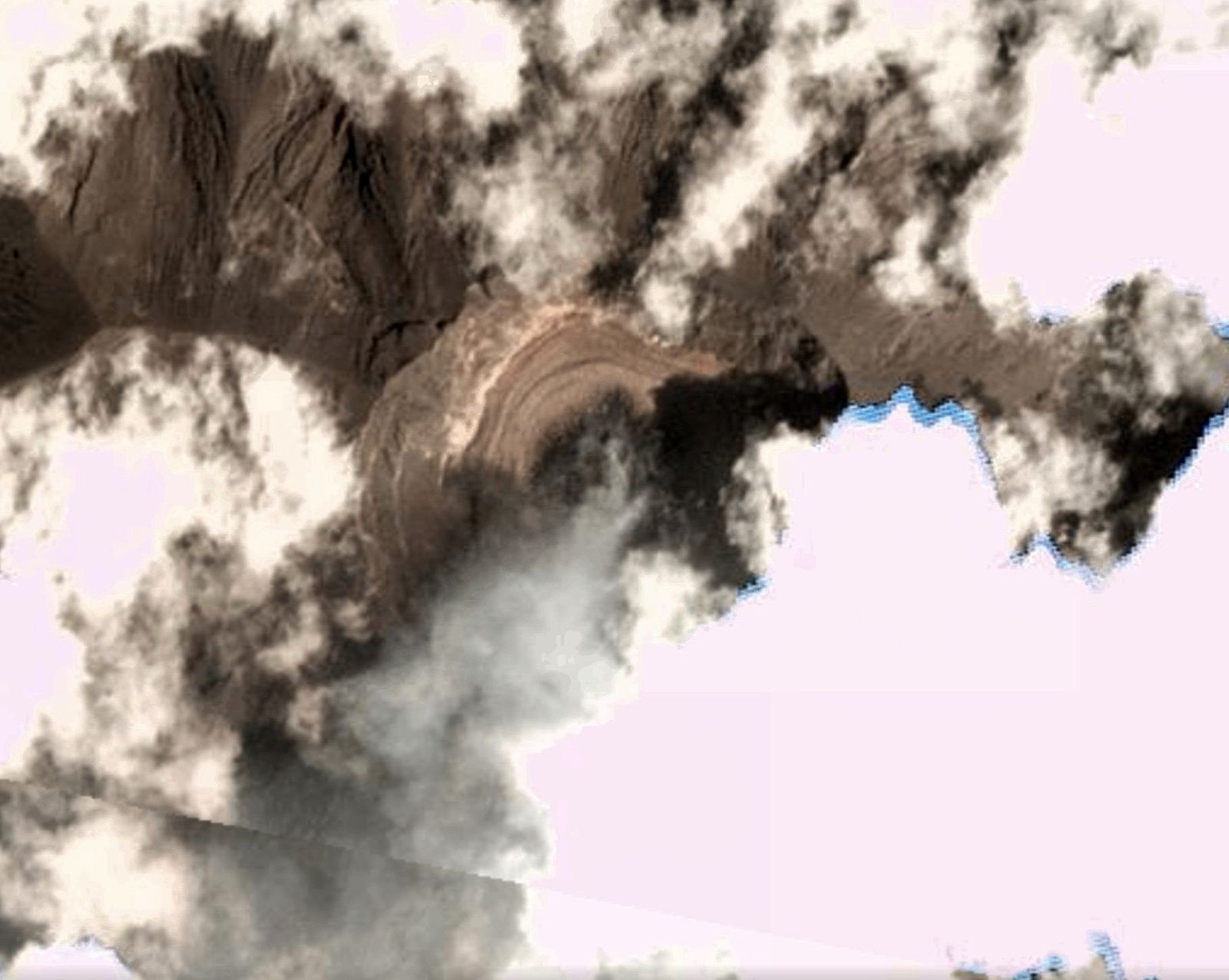
“a likely degassed dark cone surrounded by a lava flow, presenting arcuate ridges”
And now the other cam is back
I can not sign in to WordPress, (password) is it me or “it” ?
Not to say there is any comparison between Pinatubo and Agung, or that its going to do a VEI-6, but there are similarities in the seismic signals, showing pressurisation of the volcano.
And an example from Pinatubo.
Those regular and similar in size/waveform quakes do look like a very unhappy volcano…
I looked at that Pinatubo information earlier and was wondering. Maybe the ground water at Agung has created a very strong plug. Still other volcanoes look similar with much weaker eruptions.
I have also done a new graphic today, a composite of my own graphics and some IMO graphics. I call it the Grimsvotn “allroudner” since it contains the basic all round data for Grimsvotn. A few words on it in the future.
It is very HD, so open it in a new tab.
Seriously folks. If you have a paper jam, don’t angrily snatched it out of the printer. You will usually do more damage than there is. I spent an hour rolling around on the floor wrestling a printer trying to find and repair a sensor flag the user had knocked loose inside the thing. It’s not the first time I’ve had to repair damage from a user’s childish anger fit.
Still not as bad as the one that was beaten with a stick.
https://www.google.co.uk/url?sa=t&rct=j&q=&esrc=s&source=web&cd=1&cad=rja&uact=8&ved=0ahUKEwjOseKU9_nXAhWJHsAKHWcQAb0Q3ywIKjAA&url=https%3A%2F%2Fwww.youtube.com%2Fwatch%3Fv%3D78b67l_yxUc&usg=AOvVaw3UAVlK_ItrVAu2iwWaW2zH
Sounds like my son-in-law.
He’s not alone. I have one user that I had to point out to his manager that he needs to be more gentle with loading paper. Throwing the pack of paper in the tray and kicking it shut is not appropriate. He’s snapped off two paper sensor arms that I know of. (I’ve had to replace them). Now, it may just be me tossing him into a stereotype, but I think that ex high-school football linemen tend to be more aggressive with equipment than they need to be. The printer is not going to jump up and pound you into the dirt if you don’t get it first, though I think some printers should have that feature as a defense mechanism.
Caveat: I played line in highschool… it’s one reason that I stopped doing that. It tends to hurt. (A fit 210 lbs at 17, I was still not large enough to deal with the crushing forces at play)
Large plume at the moment.
Activity in Öræfajökull 12th okt – 6th december

Unfortunately Google translated
Meeting of the Scientific Advisory Council on Civil Protection 7.12.2017
December 7, 2017, 17:31
Today a meeting was held in the Scientific Council on Civil Protection of Öræfajökull. The results of the meeting are as follows:
During the past week, small earthquakes that have occurred in Öræfajökull have increased. Last week there were 160 mini-jokes. So many earthquakes have not been detected there before.
The earthquakes are predominantly dispersed in and around the top 10 km of the Earth’s crust.
The latest measurements of the seabed in the Öræfajökull caldera show that it continues to deepen and expand in accordance with sustained increased geothermal activity and that water drains from the boiler.
Measurements in Skaftafellsá, Virkisá, Kotá and Kvíá show insignificant changes in recent weeks. Measurement of conductivity and chemical composition shows that geothermal water is present in Kvíá.
Further interpretation of the measurements of last year’s crust changes shows small amounts on the southern jetty of the glacier.
Scenarios and measurements in the area indicate a small particle penetration of about 2-6 km depth below the mountain.
Over the last few weeks, monitoring at Öræfajökull has been greatly increased, watermarks, earthquake meters, and GPS GPS devices as well as some webcams have been added. Research on the ground has been increased.
What could be the proper translation of what lead to ‘small particle penetration’?
Not meaning to joke here. 🙂
Small intrusion probably. Haven’t read the original yet.
Thanks!
Yes, the original word is kvikuinnskot. Kvika means magma and innskot means intrusion.
I don’t speak Icelandic, but I know enough to understand most of the text and the rest can usually be sorted out using giggle.
Tomas, does it mean it was a small intrusion or it that part lost in translation ? It sure doesn’t look small to me and note the upward pointing wedge shape, we did see this same shape back when there was a swarm slightly wast of this same location a while ago.
I think it translates as minor intrusion.
Small is a relative measure, depends on what you compare it to. It might be small in the sense that the mountain hasn’t blown up yet 😉
Gun shot
Were you able to get a translation of any of the mini-jokes? I could use a laugh, even a mini one.
I have no idea where the jokes came in. The text says small earthquakes.
Remarkable. Shift the caldera overlay a bit to the northeast, and quakes fit on the calderas ringfault pretty well!
Don’t know what the other cams are showing, but it looks ashy to me.
Definitely ash in that last plume.
Yes, puffies are obviously more ashy today and one LF quake = one puff.
https://www.volcanodiscovery.com/agung/news/66454/Agung-volcano-Volcanic-Ash-Advisory-MINOR-DISCRETE-ERUPTION-TO-FL140-MOV-NW-AT-072246Z.html
https://twitter.com/Sutopo_BNPB/status/938951320379080704
No sand mining this morning. And the quaking rate seems to be increasing
From a back channel discussion that was mainly me asking a question and then responding to myself… 22 December is about when things should be dicey for Agung, based on a (possibly flawed) read of the events of 1963.
Cavveat: This interpretation has not be reviewed by other more knowledgeable admins of VolcanoCafe. Call it a gut feel if you like. In my defense, I am sitting here in sub-par Florida weather (potential ice and sleet) sipping Ginger Tea and Whiskey with Honey. {47+ years ago, I got deathly sick in the exact same weather and am taking no chances} I’m dry, I’m warm, and I’m quite content. There ain’t nothing outside that needs my attention. The Whiskey is double aged Jim Beam Black. Jack Daniels and I do not get along.
and here it’s sleeting and snowing and icing…. definately too warm…. and causing problems. Ginger tea and whiskey and honey sounds good but don’t forget to increase vit C tomorrow.
I am a great fan of vitamin C. I also tend to overdo it with the lemon juice in my tea.
Lurk, this is a small point but important for You…. heat (even a small amount) distroys Vit C so don’t count the lemon in Your tea…. and Ot/ how You doing with the bad weather in Your area? Best!motsfo
From the main post; “And to understand why that has happened, and what will happen soon, we need to look at what happened during the eruption.”
So, to help everyone along, here is a good paper (my opinion) about 1963 Agung.
https://link.springer.com/content/pdf/10.1007%2Fs00445-012-0615-z.pdf
From that I get the 27 day delay in the large eruption (17 Mar) following the start of 18 Feb eruptions. That’s what I base the 22 Dec dicey time-frame from. Might be something, might be me acting stupid. They also note in that paper that the crater was not full of magma at the time of the main eruption. About the only real difference with the current episode, is that it’s not flowing magma from the crater. (yet)
I won’t pretend to know if your hypothesis is dumb or smart… Wtf.. The advantage of not being the specialists responsible is that we’re at liberty to speculate, yes?
As long as any media sources reading this are absolutely clear on that point…. This is speculation, and I,for one am absolutely not qualified in any way, shape or form….
Ok, so disclaimer out of the way… on with business . GL, is there any way to factor into your thinking anything to do with the relative dimensions of the crater? It must surely have changed as a result of 63.
Possibly, but I haven’t added in the pool in the crater. I’m more interested in estimating energy release for the expelled ash events and guessing what a short period release of the same energy would yeild. It’s work in progress.
“and I,for one am absolutely not qualified in any way, shape or form…” I’d still wager Neil, that you know a lot more than any of writers of the articles of volcanic Armageddon that appear in the express, mail, etc.
Hmmm Jim Beam Black double aged. Absolutely necessary for health, of course.
Those “crash cymbal” transients are really getting busy today on the seismogram ! Anyone got a working live feed? They all seem FUBAR again.
I’ve set up some scripts to download the spectrograms and the drums a couple of times per hour, so I’m slowly building myself an archive. Makes it less of a pain to correlate events in the spectrogram with the drums, and to compare spectrogram/drum signatures from different days.
The scripts are really simple btw. This is essentially what I’m doing (warning, Linux bash code):
while : ; do wget “ ” -O $(date +%H%M%S).png ; sleep 1000 ; done
Laziness is a programmer’s greatest asset. 🙂
I love how the blog turned that literal URL in the script into an inline image. 😀
Looks like someone has been road testing about 40 different types of crash cymbal 😀
Yeah, and they push the plot off-scale all the time (that’s the red lines). Someone should really re-calibrate those sensors…
I would be happy if they just found one gain setting and left it there. At least we would have the beginnings of a meaningful datum point.
Definitely gives me the feeling that something is knocking on the door and wanting to get out.
Thanks PederP
By exploring one of Pyter’s links… I like this a lot.
http://www.smh.com.au/world/the-crisis-manager-handling-balis-mt-agung-eruption-one-tweet-at-a-time-20171206-gzzw17.html
Yeah, Dr. Sutopo Purwo Nugroho seems like a really nice guy!
Agree, he takes his job seriously but deliver with a nice twist