
Tambora’s caldera. https://cdn2.wanderlust.co.uk/media/1050/q7-tambora.jpg
In between Lombok (the location of infamous Rinjani) and Flores (with the magic lakes of Kelimutu) is the island of Sumbawa. It lies in the heart of the most volcanic region of the most volcanic nation on Earth. The two largest eruptions of the last 1500 years both came from this region. Lombok has never fully recovered from the 1257 eruption of Rinjani. Sumbawa still carries the scars of the 1815 eruption of Tambora.
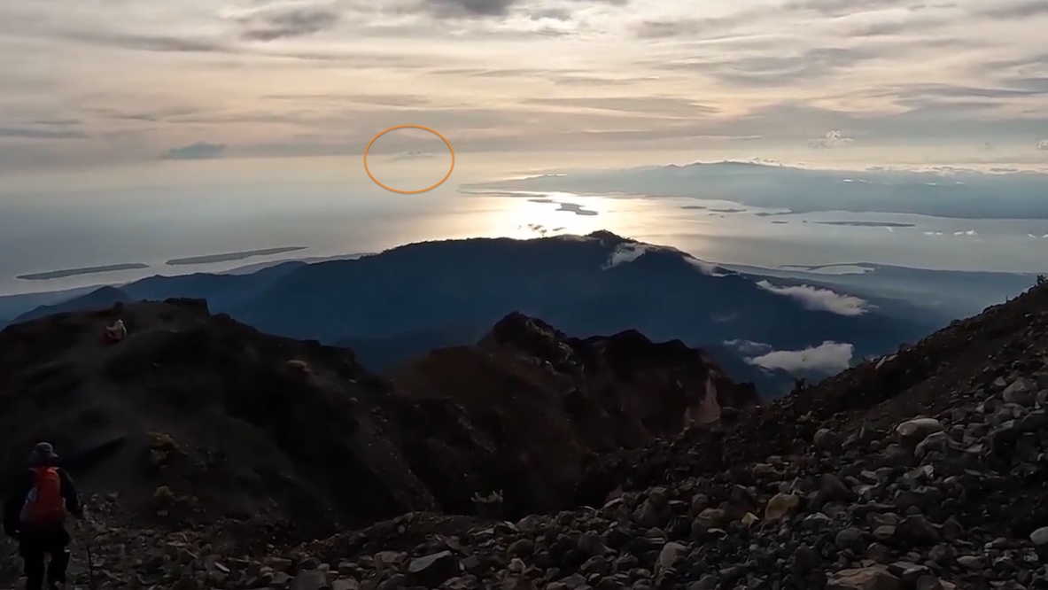
To illustrate the importance of this region for major eruptions, Tambora is visible from the peak of Rinjani, even at 160 km distance. I recently saw the direct evidence of this when coming across a video of a Rinjani climb. The screenshot below is from the peak of Rinjani: unnoticed by the climbers, the blob on the horizon is exactly in the direction of Tambora. This single shot contains the two most powerful eruptions since the demise of the Roman empire!
Sumbawa is littered with volcanoes. In fact the island is mainly a collection of volcanic mounts. But one dominated over all others. Even after self-destructing in 1815, Tambora is still the highest mountain of Sumbawa.
The Tambora eruption is the largest eruption with historical records, i.e. in modern times. This is in spite of the fact that no one who saw the actual explosion survived, so much so that we do not even have a record of what the mountain looked like prior to the eruption. The impacts fundamentally changed Indonesia. It also gave us the first indications that large eruption affect the climate worldwide – even though that was only recognized a century after the eruption. (It is in a paper by Jacques Redway, Ecology, 2, 104 (1921), https://www.jstor.org/stable/pdf/1928922.pdf). Krakatau may be better known, but Tambora’s eruption was between five and ten times larger!
Tambora’s remnant is 2850 meters tall, with a 6-km wide and 1100 meter deep caldera at the summit. We know very little about what the mountain looked like before the explosion. It may have been dormant for 5000 years, in which case it must have been quite eroded, but much of the shape was probably hidden underneath dense forests. The original surface is now buried under the 1815 deposits. We don’t know how high the mountain was either. There are estimates based on putting a cone on top but we don’t know whether there ever was a high cone. The mountain was a notable navigation point, visible from afar, but it never attracted anyone to actually sketch or paint the mountain. I therefore expect it wasn’t pretty – no Fuji-like cone, and it may not have been as high as often assumed. I won’t put numbers on it though – yet.
Why are these two VEI-7’s both here? It is hard to know why this region goes for extremes. Lombok and Sumbawa differ from the large islands of Sumatra and Java in that they are build on oceanic crust. The continental crust of southeast Asia extends into the Sunda Shelf, which ends between Java and Bali, just before Lombok. All three islands off the shelf, Bali, Lombok and Sulawesi have one or more large calderas. There is even a next one in the sequence: Sangean Island, east of Tambora. But whether there is a rhyme and reason here, or just coincidence, is unclear.
Eruption
We have previously discussed the impact from the Tambora catastrophe on the climate, which itself changed the western world: see https://www.volcanocafe.org/tambora-the-lost-summer-and-the-hobby-horse/ The following description of the eruption is taken from there:
The trouble began on April 5, 1815, when distant cannon fire was heard. Indonesia had become British in 1811, to prevent the French from taking over; Sir Raffles, the governor in Java, send a regiment of troops to investigate the attack. No enemy could be found. The next day, some ash was falling and the sun appeared as in a fog. It was evident that a volcano had erupted, but no one knew which one. Earthquakes were felt in the east of Java on the 11th, and the Sun darkened further: visibility was reduced to 300 meters. On April 12, the morning in Batavia was late. People woke up in darkness, unsure of the time, and breakfast was held in candle light. The darkness began to lift a little by 10am, by which time the first birds finally began to chirp. The sun became faintly visible only by the end of the day.
The unknown culprit was more than 500 km away, to the east. Tambora had only recently revealed itself to be volcanic. Three years earlier, people living closer to the events first noted that Tambora had acquired a summit cloud which the wind would not disperse. Later, occasional thunder was heard. In 1814, a ship which passed close to the coast reported significant activity at the mountain. A cloud of ashes blackened one side of the horizon, looking to the world like a threatening tropical squall. In fact, it was mistaken for one and the commander of the ship took in sail, and prepared to encounter it. On approach, the real nature of the phenomenon became apparent, and ashes even fell on the deck. The stories finally reached Batavia, and a Mr. Israel was dispatched to investigate. Mr. Israel reached Tambora on 9 April 1815. He did not survive.
The eruption had two main explosions, on April 5 and April 10, with the second one being much larger. The first report of ash fall is from April 3, with early explosions perhaps on April 1 according to a single report. It is possible there was a minor event at that time. On April 5, the explosions were heard throughout much of Indonesia, between 6 and 8 pm. The sounds were compared to cannon fire. There had been several smaller explosion earlier in the afternoon, reported only from Sulawesi. Ash fell in Java on the next day, and the sun became hazy. Whether anything happened over the next few days is unclear. Raffles mentions that explosions were heard on occasion during that time (and remember that he was in Java, far far away) but other reports don’t mention this, nor do we have ash layers from those explosions. So far, this was considered a noteworthy but not remarkable eruption, from an unknown volcano. The people had known eruptions like this – ash falls in Indonesia are not frequent but neither are they uncommon. It might have been a high VEI-5 or even low VEI-6 at this time, but this is guessing.
It all changed in the evening of April 10 when the eruption resumed with a vengeance. From 10pm, the explosions again were heard across Indonesia. As far as central Java tremor was felt in the ground and the houses shook. Whether these were earthquakes is unclear: the ground may just have been responding to the air pressure waves. Ash fall became intense, and even in East Java a depth of 20 cm was reported. One of the many, frequent explosions seemed even more violent than the others. The explosions continued until the following morning when they slowly began to reduce. The ash became so dense that the sky darkened and the day was as night. Bali was in darkness on the 11th. The darkness reached Java late afternoon on the 11th. It remained dark until the afternoon of April 12. Close to the eruption it stayed dark for days. The sun did not return until April 14.
Now the eruption was unique – no one could remember anything like this. And still the source of the eruption remained unknown. Reports came in of a tsunami in eastern Java, although strangely this was dated to the evening of the 11th, long after the main eruption had ended. This was at low tide, so that the 1-meter rise in the tidal river did not cause damage.
Ships managed to approach Sumbawa by the 19th of April. Large mats of floating pumice had made travel very difficult. Only now was it becoming clear that the mountain at fault was one no one had been suspecting: Tambora. The town of Bima, almost 100 km from Tambora, was found to be largely destroyed, with the port damaged by a tsunami. Closer to Tambora the devastation was complete. Throughout Sumbawa, villages were found to be abandoned with houses collapsed and people searching far and wide for food.
On April 22, a ship came close to Tambora and mentioned that from a distance of 10 km, the summit of Tambora was not visible, being enveloped in clouds of smoke and ashes. They also noticed lava streams which had come down the mountain, especially to the north northwest. There are two obvious comments here. The lava stream was likely one of the pyroclastic flows, and the summit was invisible because it no longer existed. It is strange that no one commented on the change of appearance of the mountain!
Around Tambora are several additional craters, including on the coast. They may predate the eruption, but it is also possible that they are places of later explosions, where the hot ejecta met swamps or other wet places. There are reports that explosions continued until mid July. That is the start of the dry season, and it is plausible that the explosions after April 12 were caused by the monsoon.
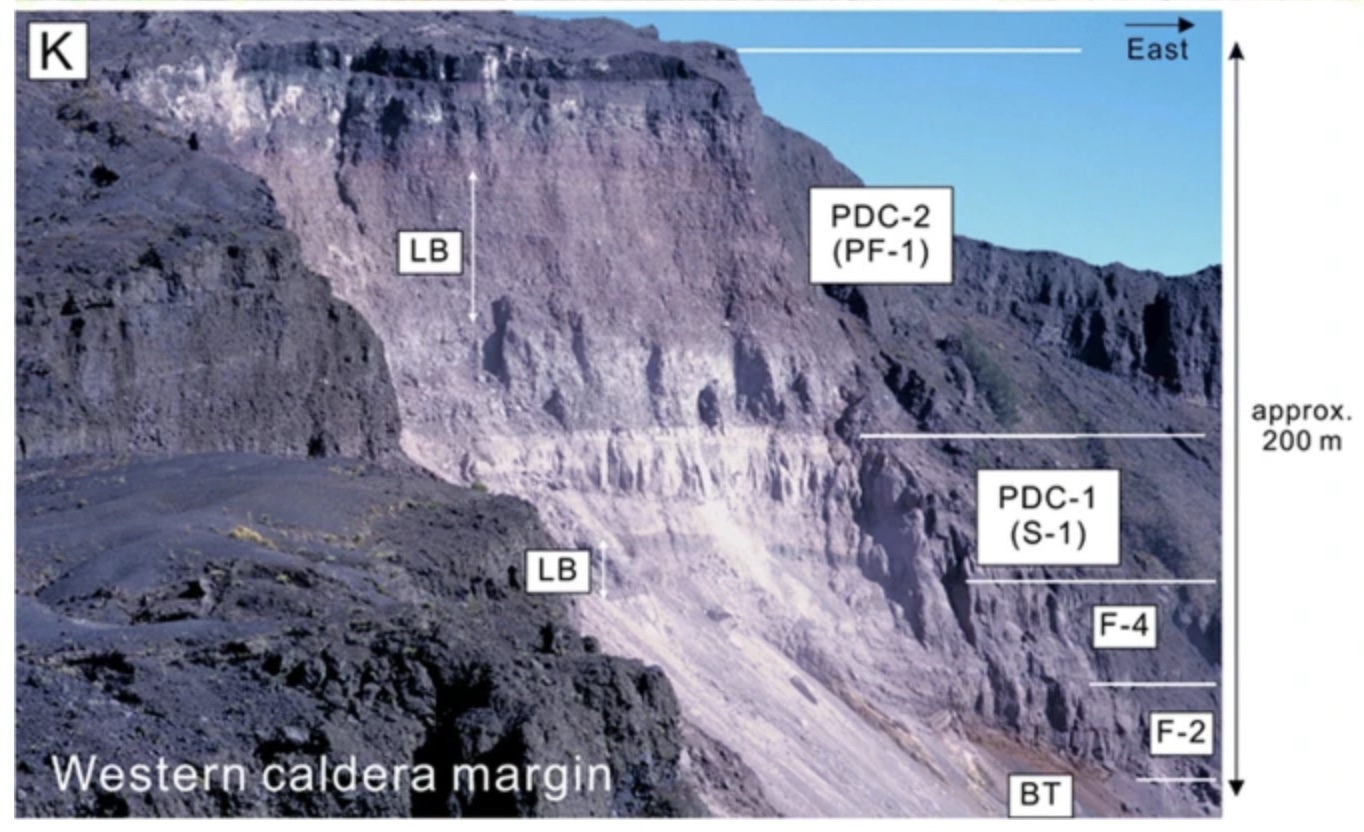
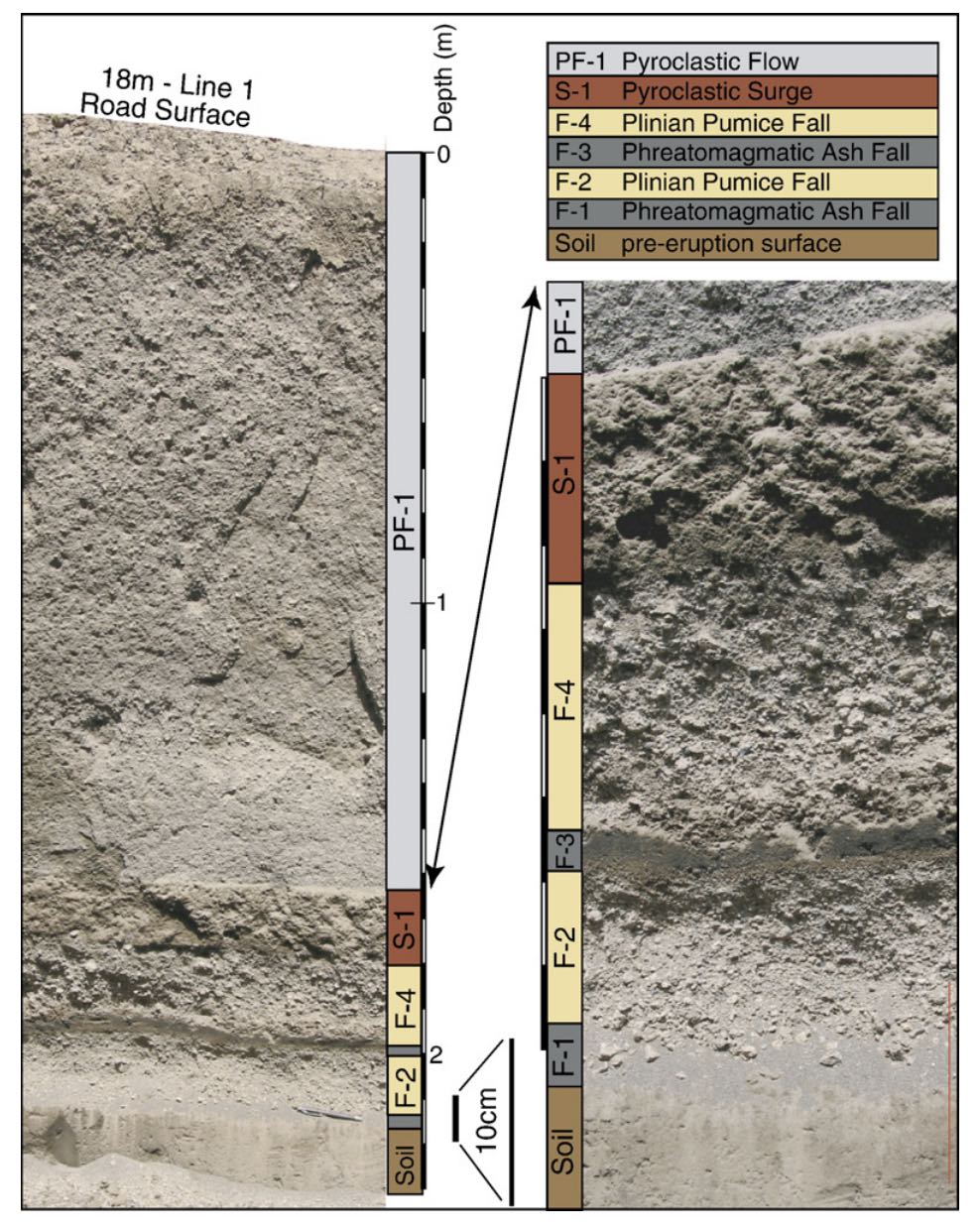
Deposits in the crater wall. The bottom layers, F-2 and F-4, come from the eruption phases on April 10. S-1 and PDC-2 are pyroclastic deposits from the end phase of the eruption. Total thickness of the layers here is 200 meters. Source: Suhendro et al 2021, Bulletin of Volcanology. https://link.springer.com/article/10.1007/s00445-021-01484-x
It is remarkable how little we know. The height or shape of the mountain before the eruption was not known. It is not known after the eruption either. The singular 6-km wide crater shows that the main eruption was a single explosion, but there is only one mention of a largest blast, on April 10 or 11. There is only one description of the main eruption, from a Rajah around April 23rd. This mentions three pillars of fire from the summit. But is unclear whether this description refers to April 10 or to April 5, or even whether it is correct. It is one comment, reported second-hand. There is a lot of speculation based on this single observation but it must be considered as unconfirmed. We just don’t know.
Tambora before the eruption
Tambora is thought to have been inactive for a long time before the 1800’s. This is reasonable for the 1000 years before the eruption, as there was no history of Tambora being a volcano. There are some 20 parasitic cones, some near the coast, but those also must be old enough to predate human memory. But we don’t know the pre-1815 history well. There is no date for the last eruption before the big one.
Satonda Island, a small lake-filled volcano just north of Tambora, has been studied as a proxy for Tambora itself. The island is 2 km off the north coast of Tambora, is 2 km across and the lake is a double crater. It erupted similar lava and as such is Tambora’s nearest relative. Radiocarbon dating suggests it’s most recent eruption was 4000 to 5000 years ago. This is often taken as the date for the most recent activity of Tambora, assuming that the two are closely related and Satonda is in effect another parasitic cone. The crater lake is surrounded by a double tuff ring. The lake was fresh water at first but around 4000 years ago the tuff ring was breached and the lake became salt water. Some time after that, the island inflated by around 1 meter, causing part of the bay to fall dry. This happened after 300 BC. Was this the inflation that heralded Tambora’s activation?
What caused the eruption? We don’t know. The magma chamber was located roughly 4 km below the surface. The magma had been sitting there for a while but with little cooling. The earliest eruption on April 5 erupted the hottest ejecta. This also contained little fragmented rock, suggesting that it did not blow a large crater. This situation also prevented significant pyroclastic flows. The second phase came from deeper magma layers with slightly lower temperatures but also contained more rock fragments: the hole had become much larger, which leads to lower pressure in the rising column and destabilizes it – the column can now collapse and produce dense pyroclastics. These pyroclastics wiped out much of the island, reached the ocean and caused tsunamis. The pyroclastic flows reached perhaps 40 km distant. But this does not say what triggered the eruption. A possibility is that water had managed to get into the magma chamber. And why the activity in the three years before the eruption? And did the inflation at Satonda Island indicate a major recharge of the magma chamber? That also is not seen in in the ejecta. But it seems like the magma chamber wasn’t that old. Tambora was not a volcano at the end of its life cycle. It may still rise again from the ashes.
Tambora exploded some 150 km3. This number was first derived by Verbeek, the same person who first pointed out the danger of Krakatau, several years before it erupted. The height before the eruption is often said have been 4000-4300 meters, but a recent reconstruction of the pre-eruption reface suggests it may have been less than that, 3500 to 3700 meters. The mountain may have had plateau with a number of separate peaks rather than a single high cone. This would fit much better with the (lack of) pre-eruption records. Note that Tambora is not that close to the coast. A flatter shape would have made it a useful navigation feature, but not a notable mountain. It would still have been one of the highest mountains in Indonesia, but not the highest. A plateau-like shape excavated to a depth of 1800 meters would be consistent both with the post-eruption caldera and with the 50 km3 (DRE) ejecta.
History
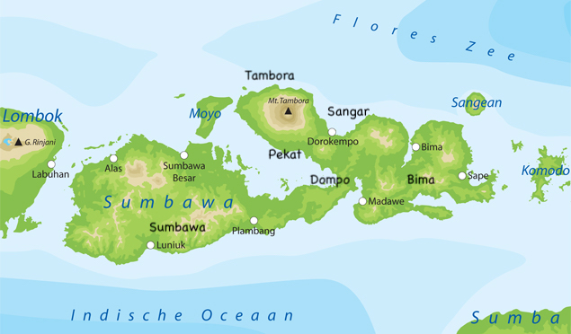
Sumbawa is one of the larger islands of Indonesia. It is some 250 km long. Tambora is situated on a peninsula on the central northern coast. The mountain has long been known but the names have changed over time. In the 1500’s, when Rinjani was called Anjani by the Portuguese, Tambora was known as Mount Aram. Anjani’s name was similar to the current one, but Tambora’s was not, suggesting the Portuguese did not know the local name. It was impressive enough for them to give it a biblical name.
The name ‘Sumbawa’ was originally only the western part of the island, and was called Sambawa, a name derived from hinduism. The island was converted by force from hinduism to islam around 1620 but the names still show the pre-islamic influence. Because the conversion was by force, the people became slaves of Makassar (Sulawesi). The only exception to this was Sangar which remained free (or rather ‘vassals’).
There were six subjugated kingdoms on Sumbawa, with approximate locations indicated below. The kingdoms were mainly small towns located on the rivers and near forests. Trading was done mainly through Bima, where rice was an important export product. The island was also known for its sapan wood (sandal wood) and for its horses.
Two of the small kingdoms existed around Tambora: Pekat (also known as Papekat) on the southern shore of Tambora and Kengkelu (later known as Tambora) on the northern shore. The peoples had different origins. The language of the people at Bima came from Flores, to the east. The language of Sumbawa and Dompo came from Java, to the west. The language spoken at Tambora and Pekat was very different, and may have been a Papuan language. The people of these areas were also said to have had a different physical appearance.
There is indeed evidence for some sort of early trade between Papua New Guinea and eastern Indonesia. Bananas were first domesticated in the highland of New Guinea around 7000 years ago, and from there spread to eastern Indonesia. Different banana species occur in the mainland of southeast Asia, which were domesticated independently but later. The word ‘muku’ for banana is of New Guinean origin: it is used in those areas in Indonesia where this early banana arrived. There are many other words in use across southeast Asia for various types of bananas, of which the Malay word ‘pisang’ is probably the best known. The word ‘muku’ was used as far west as Flores. Tambora used the word ‘much’. The population of the Kingdom of Tambora may thus have been the westernmost point of the New Guinean spread. The spread happened before 4000 years ago.
Did the Tamborians come from New Guinea, 4000 years ago? And did they survive for 4000 years in this isolated pocket on the north side of Tambora? The location was a good but isolated one: the mountain slope provided fertile ground, away from the mosquito-ravaged coast but in reach of northern trading routes, while protected by the mountain from the people to the south. After such a long time, it is likely there would have been mixing with the people of the other kingdoms or the trading partners, but evidently the appearance of the people was still different. But after all that time, the very mountain that protected them would become their nemesis.
Impacts
In one week, between 5 and 12 April 1815, the region went from relative wealth to complete devastation. All of Sumbawa was buried under ash, meters thick around the slopes of the mountain (hundreds of meters at the summit) and 20cm or more even at the corners of this large island. The typical depth was 50 cm. The north shores were also damaged by a tsunami which reached 4 meters high around the mountain but which was measured around of Indonesia. It seems surprising that an eruption at the top of a mountain several kilometers high and 20 kilometers from the coast can cause a large tsunami. The likely cause is debris flows entering the water. Atmospheric pressure waves from the explosions may also have played a role. Pyroclastic flows killed anyone within 20 km of the summit, and many further away. We don’t know how many people lived there: estimates made shortly after the disasters put it at 10,000. But that was only the beginning.
Chasse, who visited Sulawasi in 1816 on a fact-finding mission, writes ‘People still have little and insufficient information regarding the devastation which the volcano of Tambora has caused in 1815. The assumption is that the kingdoms of Tambora, Sangar and Papeka are fully destroyed and buried by lava, while the famine afterwards at Bima, Sumbawa and their surroundings has been so bad that many have died and others have fled from hunger to here.’
That is indeed what happened. Everything was buried in deep ash. People started to die of the impacts of this. Breathing in volcanic ash can be highly damaging: some people will have died of this. A plague of diarrhea began affecting not only the people but also the animals. Clearly, the water had been polluted. We don’t know by what: was it decaying organic matter? The abrasive ash itself? The suggestion has been made that it was a more common volcanic product: fluorine, an element that can occur in volcanic ejecta and was a major cause of fatalities in the Laki eruption. We don’t know, but it suggests that if we ever have another volcanic disaster, the first priority may be to provide clean drinking water. Up to 75% of farming animals died in this epidemic.
There was no food: everything was buried, inedible, and not growing. The top of palm trees provided some nourishment. People fled from hunger and started to scour the land for anything edible. Many fled to Bima, also badly affected but not buried as deep because of the prevailing winds. Others sold themselves into slavery on the other islands and in that way saved their lives. But that was not possible on the main islands (Java and Sumatra) because slavery had been abolished.
These other islands though were also affected. Already in April, a report from south Sulawesi says that there was 3cm of ash (one and a quarter inch, to be precise, but at this time the inch was not in fact precisely defined) with damage to the rice crop where the still young plants were fully buried, fish in the fish floating dead on the surface and many birds killed. Lombok and Bali were badly hit with 20 to 30 cm of ash. All their rice plants were killed and the people became completely dependent on rice from Java but without anything to pay for the rice. A report from Bali in 1816 stated that the survivors were too few and too weak to even bury the dead. This caused further epidemics. The poverty extended the famine which lasted into the 1820’s. Lombok had a population estimated at 200,00 before the eruption. This may have reduced to 70,000, although no hard number exists and we do not know how many died and how many fled. The death toll on Sumbawa and Lombok combined was given as 92,000 although again this number is very uncertain. The death toll on Bali was reported at the time as 25,000 and this is normally not included in the total reported toll.
But Sumbawa was affected the worst. The Kingdoms of Tambora and Pekat were fully wiped out, with the sultans among those who died. The Tamboran language, history and culture was no more. Elsewhere, most houses would have collapsed. The entire rice crop was destroyed. People sold everything including their children for food: one child could go for as little as 3 kg of rice. There may have cannibalism, and epidemics quickly took hold. The King of Sumbawa succumbed to disease. The population of Sumbawa was estimated as 170,000 (this is little more than a guess though). After the eruption, fewer than 90,000 were left. Perhaps 35,000 had fled the island. It took a long time to understand the scale of the disaster. The British send a single ship to help. It could do very little. (In fact, sea travel was difficult because of the large mass of floating pumice which took up to 5 years to disperse.)
Recovery
Recovery took many years. Bali and Lombok found that the land had become more fertile, and after some years the rice crop began to increase as a consequence. This started in the late 1820’s and continued, so that by the 1840’s Bali provided much of the food of Singapore. Sulawesi similarly saw a good recovery.
Flores was affected differently. There had been many deaths (we don’t know how many) but there was an unexpected change. Western Flores had been conquered by the Kingdom of Bima and paid a large tribute to them, in chicken, dogs, horses, people (slaves) and other produce. Bima was no longer in a position to enforce this, and so Flores stopped paying. This benefit lasted until the 1850’s when Bima had recovered sufficiently to re-establish the old dependency.
Recovery was considerably slower on Sumbawa itself. The first improvement was on the mountain sides, where erosion removed the ash quicker than elsewhere. Villages moved up-slope. However, this was only possible after 10-20 years. On the slopes they started growing dry rice, rather than the previous wet rice cultivation of the lowlands. They kept their traditions, showing these were the survivors, not later immigrants. It may well have included people who had fled and now returned. In the least affected part of Sumbawa, the east, the first harvest took place 5 years after the eruption. In the west it took much longer. The forest was destroyed or inaccessible, removing the main export product, sapan wood. After the eruption, the local climate had changed. The surviving inhabitants told investigators in 1847 that it had become much drier than before. The cause may have been the loss of forests, which would have reduced local humidity, and perhaps the reduction in the height of the main mountain had affected the monsoon! But most likely is that the rain water now flowed underneath the thick ash and was invisible and inaccessible.
The region of Tambora was visited in 1819. It was described as ‘horrifying’. The ground was cracked and fissured, and travel near impossible because of ash and tree trunks. Bima was in better shape. The people lived mainly on the coast, avoiding the hilly in-land. The first crops gave plenty of food, in part because not many people were left to eat it! Trees here had survived but there were no people for logging. The town of Bima was described as ‘derelict’. Few horses had survived – previously Sumbawa was known for its horse breeding. By 1824 the Kingdom of Sumbawa had also begun to recover, but Tambora was still described as ‘a heap of rubble’. And only in 1844 do we have the first record of people returning to Sanggar.
Heinrich Zollinger visited Sumbawa in 1847 and gave the first comprehensive report. He noted that much of the forest had been replaced by grassland and that much of the wet rice fields remained abandoned. Livestock used these for grazing, preventing the forest from returning. Bima had largely recovered, and even the horses had returned.
Tambora was climbed for the first time (as far as records exist) by Zollinger, in 1847. The mountain was still largely a rubble field with few plants and animals. The crater lake was seen for the first time. By 1913, small forests had returned as high as 2500 meters and there was now some sparse vegetation in the crater. A report from 1933 states that from the
lowlands to the peak, after an initially barren, dry landscape, they entered a ‘mighty jungle’ of ‘forest giants’. Higher up they found a shrubland and the summit was barren with a few Edelweiss.
The re-greening had continued by 1947 but even at this time there was little vegetation at the bottom of the crater. It was suggested that the numerous fumaroles especially on the west side made condition too hostile. An article in the Smithsonian describes the view from the crater rim: Three thousand feet deep and more than three miles across, the crater was as barren as it was vast, with not a single blade of grass in its bowl. Enormous piles of rubble, or scree, lay at the base of the steep crater walls. The floor was brown, flat and dry, with no trace of the lake that is said to collect there sometimes. Occasional whiffs of sulfurous gases warned us that Tambora is still active. https://www.smithsonianmag.com/history/blast-from-the-past-65102374/
The wild life remains limited on Tambora. This is notable in bird species, where several common species elsewhere remain absent on Tambora. This is likely caused by the 1815 eruption. During the recolonisation, the early birds got the worm and the latecomers found their niche already occupied.
There have been small eruptions in the crater. A small cone erupted short lava flows at an unknown time, possibly early 20th century. There is also a small lava flow visible on the inner caldera wall which looks quite recent. But in the main, this is just a dreaming mountain. For all appearances, it looks like Tambora has finished. Whether it will restart its growth will not be known for centuries or even for millennia.
Archaeology
Very little was known about the Kingdoms of Tambora and Pekat. That began to change only in 1980. A logging company was digging a new road (illegally) through uninhabited, very dense forest near Tambora village, 20 km northwest of the summit. This new forest had by now become an important source of timber. The diggers found a large amount of man-made material; they gathered that it was archaeological because no one had lived there since the eruption. The remains were in a layer in between the 2 meter of volcanic deposits on top and the brown, pre-eruption soil below. Michael Hitchcock investigated the site in 1980 and 1982. Pottery fragments were found to include Chinese material, but with the glazing partly melted away. Coins that were found had been kept by the loggers, but they were shown to investigators. All were Dutch and dated to the 18th century. The latest was from 1791, more than 20 years before the eruption. Was the village abandoned at this time, or was it because of the Dutch trade disruption after the French revolution?
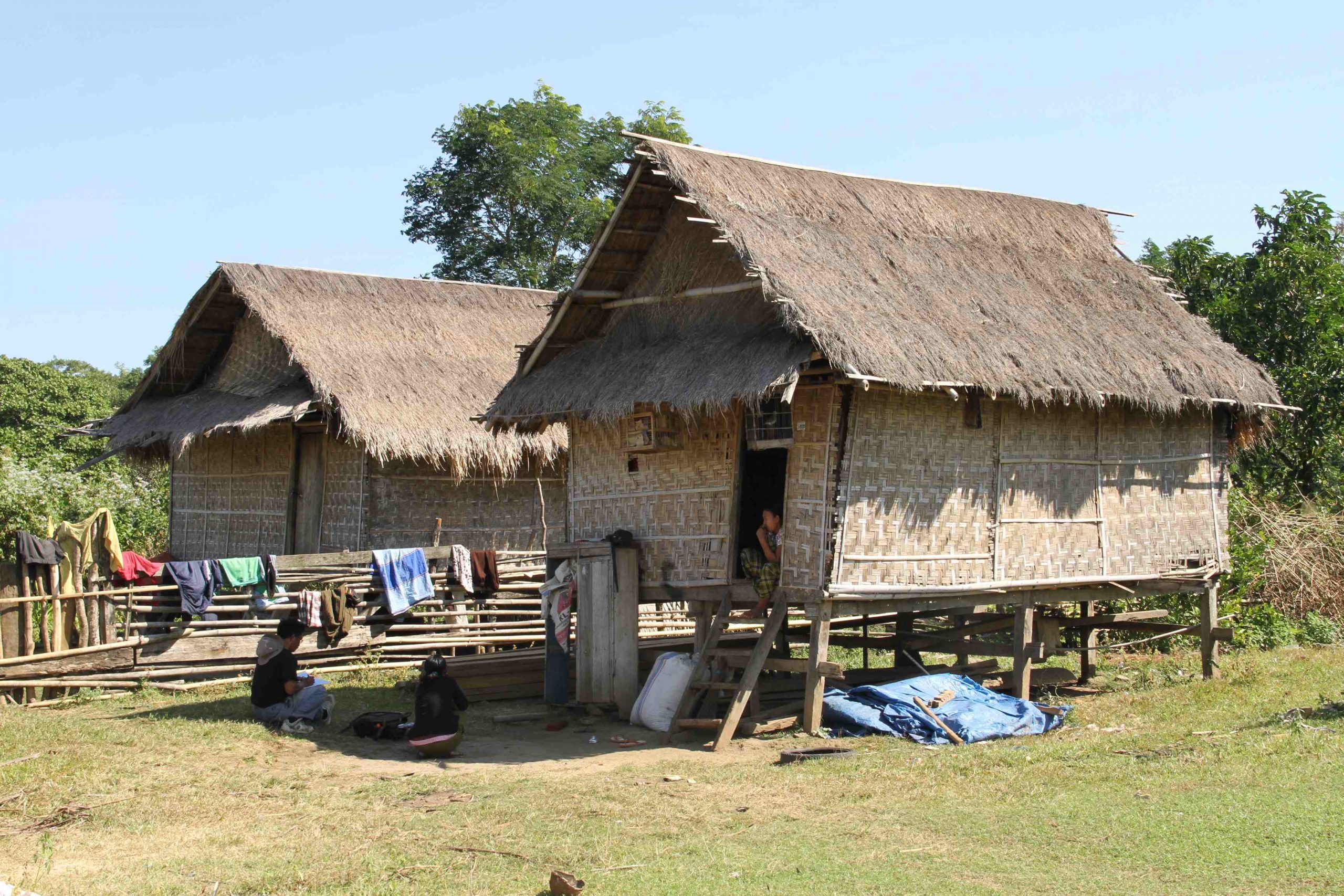
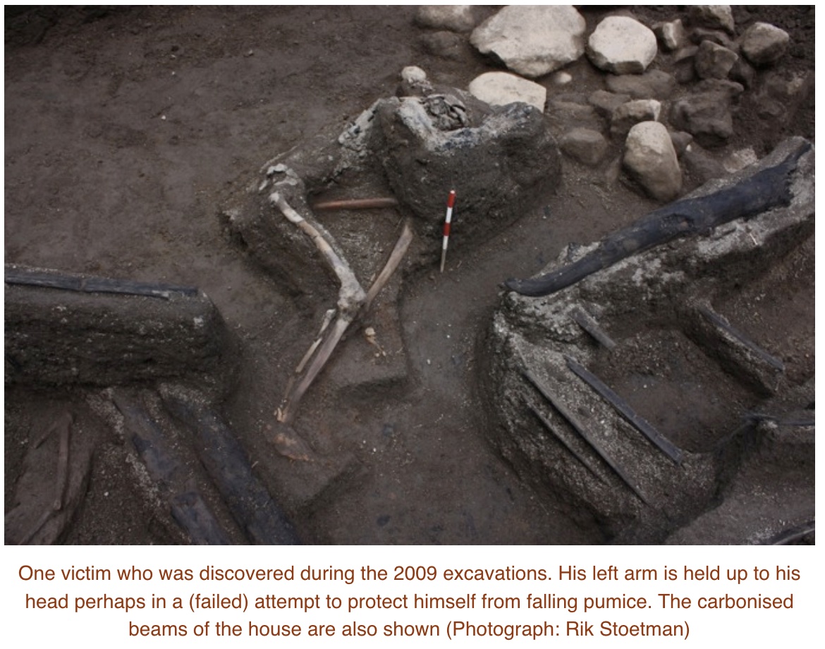
Full excavation started in 2004 and is still continuing. Not much has been published on this continuing investigation, but some descriptions have appeared. The first buried house was found in 2004, underneath 2 meters of ashes. Since that time, at least 4 more houses have been exposed (as of 2011).
The village contained several houses, in a line along what was probably a road. The houses appear to have been of similar design to what is still found in Sumbawa, build from bamboo. Several of the houses contained skeletons, in one case of a man sitting up with a ceremonial sword at his side. The bronze objects and jewels suggests that the people were quite wealthy. The various objects show a link to Vietnam. The wooden beams of the houses are burned: the ash that buried the houses was very hot. It appeared that the people stayed in their houses during the first phases of the eruption on April 5. They died when the houses collapsed under the weight of the ash and stone fall on April 10, and afterwards the hot pyroclastic flows burned the houses and the human remains.
The layering of the volcanic deposits in the area were published in 2007. The layers show the various eruption phases. Layers F1 is probably from the initial eruption on April 5. At this time, the people stayed in the houses. This is probably because the ash layer was initially manageable. The cataclysmic eruption came on April 10, with layers F2-PF1. This eruption came at night and provided no opportunity to flee. The top layer is a double pyroclastic flow, 4 meters deep – and this was 20 km from the summit! The people died in their houses.
Museum Gully deposits. Abrams and Sigurdsson, Journal of Volcanology and Geothermal Research, Volume 161, Issue 4, 1 April 2007, Pages 352-361
The bottom of the profile shows the pre-eruption surface, where people lived. This surface is terraced, which indicates human activity, such as agriculture. At the very top was the layer of new soil, on which the new forest had grown. This humus layer was only 5cm thick! This explains why recovery was so slow here – the old soil was deeply buried, and new soil took a long time to form in this devastated land.
There is evidence for three areas of settlement around Tambora, from pottery remains. This one is furthest in land: the other two are closer to the coast. All are near springs or water courses, and the suggestion has been made that this indicates irrigated paddy fields. The coastal sites tend to be near harbours, although no longer usable as such since the eruption.
source: http://forumarkeologi.kemdikbud.go.id/index.php/fa/article/view/38
Clearly the land has changed. It was more cultivated and the people wealthier, than the old records mention. This was not an isolated tribe: it was a group trading far with contacts in Vietnam, and able to obtain Chinese pottery. We know so little about them because they were wiped out with little trace. But they were an integrated part of a wider society. This is Indonesia’s Pompei – a people well off, in their cultural prime, suddenly wiped out by a disaster they could not have seen coming.
Lessons
What can we learn from Tambora? It is hard to know where to begin! We have not had an eruption anywhere near this scale for more than 200 years. What if it happens again? There are questions that need answers: would we have warning and would we recognize the signs of an impending VEI-7? Could we evacuate in time? And what would the rescue and aid look loke?
As for the signs, we really have little idea. The Hunga Tonga eruption came completely out of the blue. Pinatubo gave us 6 weeks notice, and recognizing the signs and taking precautionary action was one of the greatest achievements of volcanology in the 20th century. It prevented major loss of life. Krakatau had been erupting for several months but became dangerous only in the weeks leading up to the big one. We know that Tambora re-activated with a minor eruption 3 years before blowing up, and that there was volcanic activity in the year before the end. But we have no idea whether there were other signs. There must have been, but no earthquakes were reported and no other precursor event was noted. Was this a lack of communication or a lack of warning? Old volcanoes have a temper: they can explode quite suddenly. But one would expect inflation and perhaps drying up of ground wells in consequence. Verbeek noticed something worrying at Krakatau several years before the eruption, but never said what it was. But if there are recognizable signs, what can be done? A small area can be evacuated but evacuating an island the size of Sumbawa is impossible. How could one evacuate Naples? Tambora might even present a worst case, with a largish eruption first, so aid would be rushed in, to be met with a much larger explosion wiping out the area.
After the event, what could be done? Now, evacuation is essential but roads are impassible, ports wiped clean by a tidal wave and airports deeply buried. It could take weeks to reach the people most at need. From the experience of Tambora, the priorities would be to provide clean water and to bury the dead – very deep. In fact, cremation would probably be considered as an emergency measure. Where would the water come from? It would need to be brought in as plastic bottles, one or more per person per day.
Food would be next. Here we are probably set up better, with the UN having significant experience in alleviating famines all over the world. However, this always depends on access to the region. Even weeks after the eruption, this might be very difficult.
And then there are the refugees needing new homes. They could run in the millions, depending on where the eruption was. And after this, the slow recovery, taking decades.
Prevention is always preferable. We can’t prevent eruptions – but we can prevent some of their impact. Monitoring of volcanoes under suspicion is essential. It will take time to learn what the danger signals are. But learn we must, if we want to be ready for when it happens. The dark night of Tambora is our wakeup call – the lost Kingdom of Tambora our warning. Are we ready?
Albert, September 2023
Gunung Tambora – the mountain with the missing top
(The following addendum is entirely made up)
Excerpt from the VC post ‘Looking back at Rome’, 12 August 2063
It is now 30 years since the dramatic events at Lake Albano, or the Gandolfo eruption as it is now known, named after its first notable explosion. We remember how the activity started in the mid 2020’s, first with an unexplained rise in the water level which led to the exit tunnel becoming filled again. The earthquake which later collapsed the tunnel was unforeseen and now the lake began to flood. Some expensive properties build too close to the water were lost.
When the water temperature began to rise, the first suspicions of volcanic activity were raised. Scientists pointed out that Rome itself was build on the ash from the two volcanoes on either side. But these had not erupted for a very long time and were thought safely extinct. This attitude continued even when fumaroles developed on the crater rim, and air quality at the town of Castel Gandolfo got so bad that people started to leave.
A small eruption on the lake shore occurred in early 2031. After that, the lake stopped rising and even started to go down. The scientists pointed out that this was due to extension of the crater, which improved drainage but this fell on deaf ears. No further eruption occurred over the next two years, and it was felt that the event was over. Tourists flocked in to see the new small crater on the lake.
The VEI-5 explosion on July 12 2033 came therefore out of the blue. In hindsight, there had been warnings, such as the increase in gas emissions. At times a plume was seen rising kilometers above the lake. But in late spring when air temperature rose, the plume had disappeared. The overnight explosion destroyed Castel Gandolfo with significant loss of life, and deposited centimetres of ash as far as Rome. It was heard across Italy. Aid quickly came. A meeting was called by the government for the following week to discuss the event. This meeting was overtaken by events and never happened.
On July 16, explosions followed each other in rapid succession and people began to flee. Evacuation of the region south of Rome was ordered but quickly found to be impossible. Naples had been prepared for such an eventuality. Rome was not. Three hours later, the dramatic VEI-7 explosion followed which obliterated the area, formed a crater 6 kilometers wide and dropped 20 cm of ash and stones on Rome, 25 km away. A few hours later the eruption column collapsed and the pyroclastic flows came down the hill sides unto the plains. Luckily the wind pushed the material eastward, but much still reached the city. Buildings collapsed under a meter of ash. Even now, 30 years later, much of the area south of Rome remains uninhabited and many buildings in Rome are badly damaged.
Much has been written about this eruption, the destruction in Rome, its effect on Italy and Europe and its impact on climate. But one question remains unanswered. While all the attention had been on Naples, why had the volcanic landscape of Rome been ignored? Why had no one seen this coming?


https://www.nasa.gov/feature/jpl/europa-s-interior-may-be-hot-enough-to-fuel-seafloor-volcanoes/
Looks like Europa may have seafloor volcanoes, makes sense with its tidal heating thats also very strong. Thanks to Europas lower gravity the sea pressure at the seafloor wont be higher than the mariana trench, having water interact with an active volcanic seafloor is probaly the best condition for life you can get outside earth in this solar system. Life on Europe coud recive nutrients through volcanic vents and black smokers
Seems to be a few interesting swarms around in the last few days, Terceira in the Azores had one yesterday with a coupple of 4.0+ quakes. Reykjanes and Campi Flegri today too.
Does anyone have any data on Semeru? Geologyhub says it’s rising 1 cm/day right now.
https://youtu.be/JjdUxTURivU/
The last Weekly Report observes that “eruptive activity continued at Semeru during 13-19 September. White-and-gray ash plumes rose 200-300 m above the summit and drifted W on 14 September. The Alert Level remained at 3 (third highest on a scale of 1-4).”
The Geological Summary of GVP concludes: “Frequent 19th and 20th century eruptions were dominated by small-to-moderate explosions from the summit crater, with occasional lava flows and larger explosive eruptions accompanied by pyroclastic flows that have reached the lower flanks of the volcano.”
This partially Basaltic and partially Andesitic volcano does “borderline” explosive-effusive eruptions. It can be dangerous, but the frequent activity reduces the volcanic threat. I’d assume that it can do VEI3, but usually not much larger. Maybe vulcanian to sub-plinian.
No, but certainly worth keeping eye on given it constantly erupts often in quite deadly way. Though may well beat alternative of it not being constantly churning its system given it is Java’s tallest mountain and among a caldera complex.
Certainly worth keeping eye on given it constantly erupts often in quite deadly way. Though may well beat alternative of it not being constantly churning its system given it is Java’s tallest mountain and among a caldera complex.
Semeru is always erupting lava in its crater, not really runny stuff but it seems capable to flow pretty easily and for some distance downslope. My assumptions with its activity is that the lava just builds up and then collapses, its not really a lava dome in the same way as at Merapi or Shevluch but more like a lava cone on a too steep slope, the exact same thing seems to happen at Sangay in Equador which, like Seneru, is also a very tall stratovolcano which is mostly symmetrical but has a deep ravine on one side which has formed in recent years. Also like Semeru its generally less viscous than its neighbors, but this might just be related to constant supply keeping things hot.
Only my assumption but I think that the rising of a centimeter daily is related to this not necessarily deeper inflation.
To be honest I dont actually know where GeologyHub gets his information for Semeru, maybe he knows Indonesian and can search for it locally, or has a local contact. But last time he made a prediction on Semeru there was a collapse and a long pyroclastic flow not too long after so it does seem like he has legitimate sources for it.
Albert, you might find this very interesting (told you that many wouldn’t leave and some who leave would return).
It is like a sanctuary. Jesper might feel fine there and be accepted if he loves Gunung Bromo. About the Tengger people, finde study (and that we ourselves can push people around with diverse fears is due to the loss of religion):
“Abstract
In this paper we investigate the question not of how, but why people actively choose to
live with continued exposure to considerable hazard. A field survey of the human vol-
cano interaction at Bromo volcano was based on semi-structured interviews and focus
group discussions. The recorded interviews were transcribed and analysed according5
to recurrent themes in the answers. The facts found from the field investigation were
then confronted with the previous existing concepts. The result shows that the interac-
tion between human and volcanic environment at Bromo volcano is multifaceted and
complex. The Tengger people choose – rather than being forced – to live with volcanic
hazards because they are not only exposed to its negative consequence, but also en-10
joy benefits and opportunities of physical, spiritual and socio-cultural nature that arise
within the human-volcanic system. Following this perspective, the concept of risk itself
must be revisited and expanded from a one-sided focus on hazardous processes to
a more holistic view of risk that includes the various positive aspects that pertain to
the entire system. The development of a generic human-volcanic system model could15
provide the basis for the development of an open risk concept.”
https://nhess.copernicus.org/preprints/2/5465/2014/nhessd-2-5465-2014-print.pdf
This research is truly eye-opening! Exploring not just the “how,” but the “why” behind people’s choices to live in the face of significant danger is both intriguing and essential. The study conducted in the context of human interaction with Mount Bromo is a testament to the complexity of this relationship.
What’s particularly striking is the idea that people in the Tengger community actively choose to coexist with the volcanic risk, not out of necessity but because they find value and opportunity amidst the hazards. This multidimensional perspective challenges our conventional understanding of risk, suggesting that it’s not solely about negative consequences but also about the positive aspects that emerge within this human-volcano system.
I appreciate the call to reconsider and expand our concept of risk, moving beyond a one-sided focus on hazardous processes and embracing a more holistic view that encompasses the diverse positive elements intertwined with the entire system. This research has the potential to lay the groundwork for a broader and more comprehensive risk concept in Indonesia. Kudos to the team behind this insightful work!
This comment was held back for approval by our demon. That is standard for all first-time comments, sadly necessary. Future comments should appear immediately
We got a couple stars on the Reykjanes…
So apparently the last 3 eruptions at Fagradalsfjall have been erupting plume basalt and not MOR basalt.
https://www.mbl.is/frettir/innlent/2023/09/25/likist_oskju_og_veidivotnum/
“It seems that the magma is most similar to that which has come up from Askja, at Veiðivötn and from Grímsvötn.”
So maybe we shouldnt base our predictions on what happened in the Middle Ages…
So are we to conclude that this paper is just paper? https://www.nature.com/articles/s41586-022-04981-x and was written to use up black ink? I am pushing a point, can we get some consensus here in the scientific community or does each new paper coming along obviate all the previous ones?
Well, that paper was written in 2022, so certainly missed this years eruption and it appears to have been released before the eruption in that year too. So yes the article I linked does override that paper, because it has got much more information.
Scienfific papers, even peer reviewed ones that pass every tick, are basically destined to be proven wrong. That is literally the scientific method, to test theories until they fail… So of course that paper on Fagradalsfjall that only knew of one eruption, and for which now we have two more eruptions, that paper is outdated. It wasnt when it was written but it is now.
Chad:
Thank you for responding. If the new theory is correct, it is going to have to account for how the mantle plume is able to reach over to the Reykjanes Peninsula with that effusion. I am not sure there are too many papers dealing with sideways transfers of magma at depth. Yes, we know about sills, but this seems to be much more than that.
I dont know but one idea that could be plausible, the surge of volcabism at tge end if the last glacial. That was caused by decompression, but uf the plume decompressed and it takes 10,000 years to flow that far, then maybe we are seeing that remnant. Doesnt necessarily mean anything in regards to how large in scale the volcanism will be.
That being said, I havent seen much in regards to eruptions being so frequent as to occur yearly in the last Reykjanes cycle. It got pretty lively in the 1220s but that was close to the conclusion not the start. I can only speculate that smaller eruptions were maybe ignored unless they happened close to something important or were observed directly. It is close to Reykjavik but not THAT close. Probably only glow in the mountains and persistent vog.
The other option is that every rift did actually have frequent small eruptions, which were all completely buried by a much larger eruption at the conclusion of the rifting cycle at that location. Which, well, has quite obvious implications for the current activity. But even still, Fagradalsfjall is the only volcano to have actually erupted yet but most of the others are still showing ongoing intrusive activity, which would imply they are probably all going to erupt in the next decade or so, far from the several centuries it took for them to alternate between before.
Just to compare the recent Fagradalsfjall Fires with the Krafla Fires, her is a description of the first Krafla eruption 1975:
“In the morning of December 20 1975, there was a severe earthquake near Krafla, and at 11:08 a.m. that day, an eruption began along a 3 km long fissure produced by the Mývatn eruptions, north of Leirhnjúkur. The flow of lava stopped at 11:35, and it was all over within 12 hours. That brief eruption marked the beginning of the Krafla eruptions.”
https://icelandictimes.com/krafla-eruption-1975-84-2/
Like this the Krafla eruptions were very short, but often had longer fissures then Fagradalsfjall. Between the eruptions Krafla had a lot of deformation. There would be much hysteria if Fagradalsfjall had this deformation.
The Krafla eruptions likely resemble the Reykjans Middle Age Fires more than the current Fagradalsfjall Fires. A higher output rate, but shorter duration.
Krafla is a caldera with a magma chamber in the upper crust, so the intrusions will happen a lot faster than if the magma was coming fro ma diffuse source at depth. The general trend of a rift filling and having progressively larger or more intense eruptions probably applies but the scale of the intrusions and how fast they happen is different. We do know that at least some eruptions on the Reykjanes peninsula in the last cycle were very intense like the larger Krafla eruptions in the mid 80s, but we dont know if the eruptions just happened completely in one go or if there was years or even decades of rifting at those locations resembling the recent activity before the whole rift went off in one go.
So having looked at the two papers/sources you have each linked I don’t think they are in conflict the first paper even notes the compositional discrepancies that show an enrichment of deeper mantle material via the range of isotopic ratios which is what would be expected if there is a plume input.
They might not have outright made the connection in words but the comparisons to the Galapagos and Hawaii also suggest some similarities to plume material with the mixing between more native Reykjanes Peninsula material and deeper mantle source melt occurring down in the upper mantle being noted from the first of the current intervals RP eruptions. In particular it mentions MOR Basalt usually has a more consistent K2O/TiO2 ratios which in terminology means its not really MOR basalt.
So these papers actually largely agree in terms of what is going on they just are framing it differently with the first paper trying to avoid model dependent descriptors where possible. The key point to note here is that magma mixing and storage for Fagradalsfjall is below the usual delineation used to separate the crust from the mantle.
Now for Randall’s commentary based on what I have read about the Snake River plain there is a fair amount of parallels there with the Yellowstone hot spot Snake river plain and Siletzia sharing distinctive chemical signatures and a general evolutionary curve as the overlying lithosphere’s composition shifted.
https://www.sciencedirect.com/science/article/pii/S2666277920300046#sec0021
Also if we recognize from the Seismic tomography of the East Pacific Rise and western North America the solid mantle buoyancy/temperature anomaly that forms the periphery of the Basin and Range Province + the Colorado plateau appears to connect directly to the Juan de Fuca Ridge and the East Pacific Rise with areas which have had recent volcanism generally being within relatively close proximity to this ridgeline structure, then the parallels look particularly strong with the main difference being there is now a continent sitting on top of this counterpart. I also should note that in this perspective the Snake River plain and the RP also share a characteristic of having perpendicular extension relative to the rest of the general ridge structure occurring adjacent to the main ridge structure.
The latter quality of extensional activity perpendicular to surrounding zones also applies to the Azores hotspot as the region of the plate boundary referred to as the Azores Gibraltar fracture zone also displays extensional behavior rather than the compressional behavior seen elsewhere along the fault boundary.
Thus in this case it may be that perpendicular rift zones are a natural consequence of a hotspot emplaced on an oceanic ridge system capable of transforming what would otherwise be a transform offset into a zone of active spreading due to the increased heat flux.
Hotspots tend to have an extended uplift dome around them and these perpendicular extensional zones seem to lie within the dome area as far as I can tell.(and yes hi I’m new here got linked here by a comment on Geology Hub)
The mbl.is website does not have enough information to judge. It may well be referring to the same effect seen in this paper, and just pointing out that such magma also has been seen at Askja. Interpreting this as the magma coming from there would be a stretch, and rather unlikely. The Nature paper points at a stratified magma source, with the magma which reaches the surface a bit later coming from much deeper. It says the magma was stored at the Moho – that is rather likely, but there is a second transition zone at 6-7 km depth, between the crust and the lava pile, and that also acts as a resistance which rising magma has to break through. The dikes start from this level. So the storage and transport remain under discussion, but the source of the magma melt is deep. There is a variation in elemental abundances seen between the Atlantic rift and the Icelandic volcanoes. They seem to argue that Fagradalsfjall is Icelandic, not Atlantic.
As to which result is better, those discussions take a long time to complete. This is not politics where shouting slogans makes right. Different teams will argue different positions, and over time the data will shift the discussion one way or another. Things can get heated, but it is more like sport than war – there are rules and the data acts as referee.
Top.
I totally agree with that statement.
This paper, Randall, is indeed brillant. You only have to study the contributors’s list to see that, but I also read it:
Authors and Affiliations
Nordic Volcanological Center, Institute of Earth Sciences, University of Iceland, Reykjavík, Iceland
Sæmundur A. Halldórsson, Edward W. Marshall, Alberto Caracciolo, Simon Matthews, Enikő Bali, Maja B. Rasmussen, Eemu Ranta, Jóhann Gunnarsson Robin, Guðmundur H. Guðfinnsson, Olgeir Sigmarsson, Quinten H. A. van der Meer, Geoffrey K. Mibei, Maarit H. Kalliokoski, Maria M. Repczynska, Rebekka Hlín Rúnarsdóttir, Gylfi Sigurðsson, Samuel W. Scott, Ríkey Kjartansdóttir, Barbara I. Kleine & Andri Stefánsson
Laboratoire Magmas et Volcans, Université Clermont Auvergne, Aubière, France
Olgeir Sigmarsson
Department of Earth Sciences, University of Cambridge, Cambridge, UK
John Maclennan
Department of Earth Science, University of California Santa Barbara, Santa Barbara, CA, USA
Matthew G. Jackson
Department of Geosciences, Swedish Museum of Natural History, Stockholm, Sweden
Martin J. Whitehouse & Heejin Jeon
Icelandic Meteorological Office, Reykjavík, Iceland
Melissa Anne Pfeffer
Department of Geography, University of Cambridge, Cambridge, UK
Clive Oppenheimer
Dipartimento di Scienze della Terra e del Mare, Università di Palermo, Palermo, Italy
Alessandro Aiuppa & Marcello Bitetto
COMET, School of Earth and Environment, University of Leeds, Leeds, UK
Evgenia Ilyinskaya
Istituto Nazionale di Geofisica e Vulcanologia, Catania, Italy
Gaetano Giudice
Correspondence to Sæmundur A. Halldórsson
I recommend to whoever wants to debate this paper all by himself to first write to
Sæmundur A. Halldórsson.
Fagradalsfjall seems to be the SW border to where the plume reachs to. Maybe we currently see two parallel developments: The reactivation of the MAR oriented rift system (Reykjanes) after 800 years and the reactivation of the shield volcano Fagradalsfjall after 8000 years.
Campi Flegrei: a M4.2 quake during the night. I have to look it up, but this is the biggest quake in a long time there.
Actually it’s the biggest so far. I found this list:
M4.2, 27 september 2023
M4, 4 october 1983
M3.8, 7 september 2023
M3.6, 18 august 2023
M3.6, 11 june 2023
M3.6, 29 march 2022
M3.5, 16 march 2022
M3.5, spring 1983
There is a risk for sudden phreatic eruptions. They are small compared to plinian eruptions or magmatic eruptions (Monte Nuovo), but they can cause deadly devastation like White Island 2019. Phreatic explosions are unpredictable, because they don’t need magma to reach the surface. Water-magma-contact somewhere below is the condition.
If the current increase of unrest continues, then at some point a limited evacuation needs to be considered. For instance Pozzuoli and nearby villages. Pozzuoli was evacuated after the M4 quake in 1983. There was a 4.2 today, so we may be nearing that point.
Personally I wouldn’t live there. The risk for a house to end as a volcanic bomb or as an aim for a volcanic bomb is too big.
Yes you might if you had grown up there.
Read what I posted – more for Albert – yesterday between 6 and 7 pm.
It is maybe a bit similar there – slightly – to indonesia, concerning the blue sea and the islands. It is without any doubt much more beautiful than many a bleak city in northern rain.
So if you consider as an Italian moving to Milano, you first ponder whether you want to exchange the beauty of a volcanic landscape to a sky like lead from November into April. The same goes for Berlin btw. Grey, moist and coldish in winter.
You might stay and rely on the commune of Naples or the State of Italy to evacuate you on time when there is the chance of an eruption.
I have seen a disaster documentary about Campi Flegrei though. Basically if Campi Flegrei did a Tambora revival nothing in Europe is really so safe, concerning food and health and transport and drinking water.
Our economy limping on two to three legs instead of galloping on four would take a terrible blow if that happened now.
Italians are very well read and often studied – they have brillant high schools. So they might know some of these things.
Is there any information on the gas emissions and their temperature, and inflation patterns? Evacuation should be considered if all three indicators point at magmatic trouble
No significant changes at Campi Flegrei besides a slight increase in inflation. However, I would be shocked if things don’t escalate, looking at the seismic activity over the past year shows that these swarms have been regularly gaining in intensity.
The INGV has a tough challenge ahead with this volcano as the moment they even mention evacuations the media is going to break with rabid headlines “Supervolcano ready to erupt!” and in the same vein, they can’t really diminish the threat because a tiny VEI 2 could kill dozens of people. Let alone a VEI 3-5 which is a perfectly reasonable scenario for this volcano. Their actions have to be precise and almost perfect in order to avoid mass panic and to adequately prepare for what the volcano can do.
I haven’t seen this yet. But I a friend of mine in a discord make a updating 3d plot of the earthquakes. Its very barebones. But each square is 1km. There are some very interesting feature that were described in this study (https://www.sciencedirect.com/science/article/abs/pii/S0377027319300046) that can be seen in the earthquake plots.
link: https://vic-at-personal.github.io/campi-3d/
CF, Pozzuoli, 2000-2021, earthquake study
Picture:
https://www.nature.com/articles/s41598-022-06928-8/figures/8
article
https://www.nature.com/articles/s41598-022-06928-8
I studied that more today, Tallis. This one single 4.2 quake 27th Sept. 1:35:34 am
was a little eccentric, in between Pozzuoli and Naples and possibly under a small crater island with the name Nisida. Brutus is supposed to have had a summerhouse there 😉 Much later it was a prison island, described by Gladstone (terrible conditions). Last but not least it is in the ocean near the coast and contains a crater.
I don’t know though whether the island is above that quake. The area is right. 10.2 km southwest of Naples. Ischia is about 35 km west, Procida a little less.
Pozzuoli is like 10 km northwest, Monte Nuovo and the lakes even more to the west.
Some nice Photos showing how fluid the Hawaiian lavas are, very low viscosity indeed
Still Kilauea, Mauna Loa, Nyiragongo and Nyiramuragira are the sillicate based volcanoes with the lowest viscosities today and they are all about as low I guess
If the deep magma in Kilauea is 1650 c then it woud flow very much like water at souch temperatures, iron slag also do that at over 55% Sio2 But I doubt we will see a direct astenosphere Hawaii eruption anytime soon
I see no photos here.
They vanished its a bug
The server at decadevolcano.net has a bad security certificate so they can’t be served over an https connection. If you go to the non-secure version of the Volcano cafe page the images will show up – that is http://www.volcanocafe.org/tambora-making-history/
However hot-linking images from someone else’s server is considered bad form. Better to link them from an image hosting site (although copyright might come into play) but with a link back to original web page. Also good to ask the site owner first.
In this specific case images at decadevolcano.net are marked as “Copyright: Before using photos of this page elsewhere please contact Tom Pfeiffer.” So shouldn’t be either hot-linked or uploaded elsewhere without permission.
Okay. Me neither 🙁
https://volcano.si.edu/volcano.cfm?vn=344100
And some peles hairs from Masaya showing that it too have some incredibley low viscosity
And a temperatures measurements from the lava lake showing over 1200 c making it perhaps the hottest of any land subduction basalt, this is even hotter than Holuhraun I guess Masaya magmas rise quite quickly from depth without evolving that much and explains the high temperatures and almost hawaiian fludity
Something that may intrest Chad, you probaly been curious how hot Masaya really is and here is a valid temperatures measurements, Hawaii and Iceland is hotter at depth of course, althrough Masaya is certainly insanely hot for being a land subduction basalt, when most other subduction zone volcanoes struggle to go much above 980 c ..
The temperature of open vents is often hotter than the magma, some of the gas composition will oxidise and burn at the opening. Tholeiite basalt is chemically reduced with iron present as Fe2+, at the temperature of lava this can react with water and make hydrogen, and that can burn with visible flames in some cases. It also makes elemebtal sulfur and H2S although I am unsure of the exact reactions going on, but at 1200 C both are also gasses and will burn too. There are temperature measurements of 1250 C at skylights on tubes from Pu’u O’o, about 90 C above the lava temperature, and this wasnt even a vent just a skylight. And back in the early days of HVO there was a fumarole in Halemaumau with a measured temperature of nearly 1400 C, the lava wasnt that hot but the surface of the rock can be at the edges of those vents. Hydrogen burns at over 3000 C in air so this is not all that surprising in a way. Sulfur burns hot too, the blue flame is due to photon emission from exited sulfur molecules and not black body radiation but the S=O bond is very strong so I expect burning sulfur gets pretty hot still.
Lava at Masaya is supposedly about 1115 C, about 100 C lower than the above picture.
https://www.sciencedirect.com/science/article/abs/pii/S0012821X21003939
The burning gases also explains why some early explorers tought fluid volcanoes to be giant natural iron foundury furnaces, in Masaya they tought it was liquid gold .. only to discover it solidifyed ”into a black horrid mess” when chained buckets where pulled from the lake … and at great anger to the greedy spanish colonizers that tought the gold was cursed by the devil
The 1115 c figures coud also explain why Masaya does not always look as smooth as Halema’uma’u did in 2008 when the lava raged at depths in the overlook crater its probaly also more crystal rich. But both are certainly very fluid. Masaya is probaly only sligthly less fluid than Puu Oo
https://m.youtube.com/watch?v=ep-IaIYGVq4&pp=ygUWc2FudGlhZ28gY3JhdGVyIG1hc2F5YQ%3D%3D
This video from Masaya looks very hawaiian or at least like Erta Ale
Beautiful pic
Nice Pele’s hair. Masaya is interesting. The Nejapa-Miraflores alignment, the fissure line next to Masaya that contains the Apoyeque volcano, often erupts basalts with as much as 10 wt% MgO, which is more than typical. So there are some unusually magnesian magmas in that area. I’m not sure if Masaya has these magmas too, but it’s certainly very primitive, despite having a large shallow magma chamber at present, it doesn’t seem to evolve much. Maybe there’s some kind of oceanic crust forming in the Managua Graben.
Sounds legit its not a normal subduction zone setting, althrough superrunny lavas are not excluded from subduction zones .. Villaricca and Ambrym are good normal examples its all due to how fast it rises from the source .. most subduction volcanoes are on thickened crust and have very slow supplies so only erupts silliecous mushes
Masaya is a trapdoor caldera, with a ring of vents surrounding a resurgent block. The magma chamber is perhaps some 4 km wide, not as big as it once was, but still quite capable. One day Masaya will unleash its fury in Managua when the block collapses. I think a rifting event could act as the trigger.
I doubt it’s more fluid than other basalt subduction zone volcanoes, it’s probably like Ambrym, Ambae, or Shishaldin. It’s just that basalt is rare in a subduction zone. The Nejapa alignment might have hotter magmas though, since those are unusually magnesian and probably come straight from depth during rifting events.
Both Villaricca and Ambrym are highly fluid, here is a Villaricca dome fountain and only low viscosity lavas can do that. Looks quite close to Hawaiian in viscosity so very low viscosity subduction basalt
http://www.italysvolcanoes.com/Villa_recent.html
Apparently, Masaya’s magmas are almost pure melt. The following thesis describes a series of samples from Masaya lavas, and most have 1-3 % phenocrystals. Almost pure melt. That probably matters regarding fluidity and temperature. A lot of stratovolcanoes erupt highly crystal-rich lavas that despite having mafic overall compositions, have more evolved melt in between the crystals, and lower temperatures. Masaya having pure basaltic melt is probably significant.
https://summit.sfu.ca/_flysystem/fedora/sfu_migrate/16592/etd9613_JZurek.pdf
Impressive and Hawaii is the same at the summit?
Yes that will make it alot less viscous as crystals are like sand in a soup, and explains why Masaya easly forms paheohoe, the rather rough look of the lava spatter are probaly beacuse of its very high gas content its a magma foam sloshing around, which its shares with Ambrym althrough that one haves more crystals
Kilauea’s summit is less crystalline even, sometimes with 0 % phenocrystals. Usually less than 1 %. The only eruptions with high crystal contents are those that are unusually magnesian, like 1959, or December 1974, which carry abundant olivine crystals:
https://academic.oup.com/petrology/article/44/12/2313/1460265
During the Observatory Shield age, I think Kilauea was more crystalline though, going from memory. ERZ eruptions are also more crystal-rich since they come from satellite magma storage but are overall crystal-poor compared to other subaerial volcanoes.
1-3% crystals is still crystals. I think possibly the shiny abd smooth very characteristic appearence of pahoehoe in Hawaii might be down to a few factors beyond the composition of the lava and its physical characteristics.
More alkaline mafic lavas seem to just make black looking rock, and the flowing liquid seems to stay incandescent for longer, I think possibly the thin crust is actually partly transparent in these lavas. La Palma in 2021 is my main example. There was a lot of pahoehoe formed in that eruption.
Lava in Iceland is pretty much the same as in Hawaii mostly, but again the lava looks different. Pahoehoe there is also blackish but also a bit spiny. The spiny appearence is maybe crystalization in the upper crust just before eruption. But the colour really couldjust be the far northern location, not as much light.
A while back now the Hawaii Podd team did a video about the origin of the Hawaiian plume. I cant remember much but one of the most notable things is that the plume is very deep, and probably created by ancient subducted slabs plunging into the contact with the outer core and a direct chemical reaction of the basalt with the molten iron. If I had to guess this probably has something to do with the appearence of Hawaiian lava along with the light conditions.
The liquid core and the very hot but solid mantle is separated, they never mingle but yes thats a possible explanation, its the ultramafic mantle rocks getting enriched by iron then, reading many papers hawaiian basalts tends to be quite iron rich in many sources
I’ve read this VC piece which is brillant concerning human history and the then Spaniards’ lust for gold and well written.
Then wikipedia. Not totally understand the setting. If you feel like writing a second VC article with all your good explanations and pics about the setting (maybe including the risk) I wouldn’t be too unhappy.
https://www.volcanocafe.org/masaya-volcano-the-mouth-of-hell/
Its not that subducted slabs mix into the mantle, rather that the basalt they are made of reacts with iron at the boundary under those conditions.
That they react is certain, the two have been exposed to similar conditions in experimental settings and they react immediately. I think the role of geochemistry or just chemistry in general is neglected in this consideration, at ambient pressure yes very few compounds can exist at 3000+ C, but compressed in the core of a planet the pressure is so high the materials are basically solid anyway regardless of temperature, their momentum is basically negated by pressure, so interactions between atoms should be expected.
Like, temperature of atoms is based on their kinetic energy, but if atoms are compressed into a solid at high pressure then they dont have enough momentum to overcome that pressure. Maybe chemistry at those conditions is not like usual redox chemistry but interactions still occur.
On that note too, I wonder if chemistry can happen on neutron stars. Neutronium would probably be a noble gas at ambient conditions, as it has no electrons to interact with, i guess why it is sometimes called ‘element 0’. But the very surface of neutron stars is made of actual atoms, really weird atoms with way more neutrons in the nucleus than possible elsewhere but atoms nonetleless, at least in the first few cm. But any normal atoms present would be in the electron degenerate state so maybe interaction is impossible anyway, maybe Albert can clarify. But before that point things should still interact I would think, as electrons are still free to move if something more electronegative is around for them to move to.
Interesting conversation crystallization is an interesting and complicated subject. Yeah Seismic tomography certainly seems to paint a far more complicated picture for subducted slabs with the slabs sinking down to the core mantle boundary acting as the downwelling component of Earth’s internal convection with phase transitions occurring along the way which can result in the release of various sediment derived components of the slab becoming expelled and if they get concentrated in great enough numbers even remobilized into compositionally derived plumes.
Now for the outer crust of neutron stars(where atoms still exist) or even white dwarf stars you don’t really get traditional chemistry since the extreme temperatures and pressures mean everything is fully ionized plasma that said crystallization does occur as the atoms still arrange themselves into a lattice structure though for reason which have more to do with the Pauli exclusion principal than traditional chemistry though its not really well understood ATM.
There clearly is some complex physics ongoing there since we observe peculiar properties and events that otherwise are difficult to explain such as Neutron star “star quakes” and even in the case of the most extreme class of Neutron stars Magnetars eruptions of material at significant fractions of light speed(as neutron star escape velocities are large fractions of the speed of light)
Modeling largely based on the detailed analysis of the nearly Kilonova and experiments looking at nuclear structures suggests the interior of neutron stars beneath the iron rich crust is complicated featuring at first atoms that become increasingly neutron rich with depth relative to atomic mass number before at some point the boundaries of atomic nuclei start to blur together into strange more complex structures which have been named after their pasta like shapes. But unlike the conventional picture of “pure neutronium” even at this point there would still a few protons and electrons hanging around just with their number densities exponentially dropping off with depth, and the nuclear states are at the very least complicated and poorly understood.
We now know the nuclear strong force plays a significant role in addition to neutron degeneracy pressure to stabilize neutron stars. So it seems probable that chemistry like interactions should occur only mediated by the strong force rather than the electromagnetic force.
That said getting back to the subject of volcanism the enigmatic Magnetar flare events while extremely exotic seem to have a number of parallels with volcanism and thus by some twisted definitions might be considered volcanic systems.
I wonder what the VEI of a neutron star eruption would be then 🙂 probably bigger than the mass of the earth. I think one of the magnetar eruptions was the most energetic event observed in the Milky Way with modern instruments, not as big as a supernova but larger than a regular nova.
I have seen hypothesis that magnetars are basically black holes that havent formed yet. As in, they are over the limit but held up against collapse by their rotation which is radiated by the magnetic field. I dont know if this is generally accepted though. But it would give an explanation of why magnetars are so rare and apparently all very young.
Very impressive that explains why halemaumau lavas are as smooth as liquid alumimium
Alkaline lavas are much less Sio2 laden, and specialy so for ultrabasic lavas like basanites and nephelinites, so they dont form a nice sillica sheen, many Nyiragongo lava lake overflows been very dark for soure and only gets a grey lustre in daylight, they are too sillica poor for shineyness
Shineyness is also a sign of very low viscoisty and low crystal contents forming a nice glassy plastisticy on the lava flows. Iceland haves alot of nice halemaumau looking paheohoe and last time was close to vent in fagradals 2021 and surtsey in 1964 and the large shields also have hawaiian looking pahoehoe
Should Villarica do a Nyiragongo we can invite in the neighbors and offer up, popcorn, beer, wine, and soft drinks, and sit huddled around the screens watching the show. Woe be to those at Ground Zero.
We make you 15 km tall and gives you a giant dimaond saw.. and lets you saw off the upper summit cone of Villaricca.. and you gets a Nyiragongo..a rather cruel and radical way to do it : D
If memory serves, the last one out of Africa was a surprise, flank attack
that couldn’t be out run. Can that be ruled out for Villarica given the fluidities being compared?
I guess there is not as much magma in villaricca as there is inside Nyiragongo,
it mostly does tall paroxymyal lava fountains and the conduits are much narrower in villaricca, any flank eruption there often forms cinder cones or small lava shields, etnas flank eruptions are probaly analougus to villaricca with some added fluidity, when Villaricca does erupt outside the summit
You cannot outrunn Mauna Loa either if you where close to the 1950 vents
Details appreciated. Thank you.
That is maybe the funniest thing, Jesper, I have ever read coming from you.
It reminds me of myself being a child and see somebody decpitate a champagne bottle with a sabre.
More and more supervised by French State, submarine surveillance in planning: Fani Maoré
Finally, there are plans for an underwater station called Marmor. Managed by Ifremer and located on the Fer à Cheval, it will carry out permanent and continuous monitoring of seismo-volcanic activity and associated phenomena such as plumes.
“Every morning, I receive the Révosima bulletin in my e-mail. I can then see if the earth has shaken in Mayotte. If it has, the bulletin informs me of the magnitude of the earthquake, as well as the location and depth of the source,” says Éric Humler, one of the architects of the scientific response to the 2018 seismic crisis. Révosima is a fine example of the integration of various disciplines. It’s a model of how to react in the event of a crisis. It’s a model that can be applied beyond Mayotte, for example in the French West Indies, where there is also volcanic activity and underwater tectonics. One thing is certain: if another seismic or volcanic episode occurs in Mayotte, the scientists will be ready to manoeuvre.”
Translated with http://www.DeepL.com/Translator (free version)
Article with some good pictures:
Fani Maoré, le volcan sous-marin qui a fait trembler Mayotte
01.03.2023, par Sebastián Escalón
Put in google, can be translated in your language.
https://lejournal.cnrs.fr/articles/fani-maore-le-volcan-sous-marin-qui-a-fait-trembler-mayotte
There is a fair swarm of quakes building up at the moment near Sandfellshæd in the Reykjanes/Svartsengi volcanic system Iceland. Perhaps a new intrusion is taking place in the region like in mai 2022. Main activity seems to be around 5 – 6 km depth.
Screenshot taken from https://vafri.is/quake/#close
I noticed that too Rob. At a rough count 78 small quakes between 7 and 8km WNW of Grindavik. I have seen swarms there quite a lot but I do think the Icelandic MO will be keeping at least half an eye on what is happening down there but depths are not appearing to get any shallower so no worries yet awhile.
Drumplot Rauðhóll doesn’t show overexcited, but the list is showing lots of micro quakes.
Credits plot IMO.

GPS shows no uplift (yet) though.
We might not write here. The website wouldn’t exist. We might not be;
40 years of an individual’s – a very responsable and sane individual, Stanislav Petrov – personal decision:
https://en.wikipedia.org/wiki/1983_Soviet_nuclear_false_alarm_incident
Have some beers tonight.
“We” are more dangerous than the T-Rex, the Reticulated Python and all the volcanoes of this world together. If it weren’t for sane people with a sense of responsability. No AI will ever be able to top that.
Concerning yourself, Albert – I wrote a wish to Héctor – I would like it very much if you did a series about East Java. You can read all the original Dutch sources, and the area is very interesting.
As long as no volcano erupts spectacularly it might be an idea what to tackle.
The Phlegrean Fields seem…restless.
I dread to think what the situation would be like if they actually had to evacuate.
Hopefully just a slight hiccup and it goes back to sleep.
Campi Flegrei: No signs for imminent eruption says Francesca Bianco, director of INVG:
https://www-corriere-it.translate.goog/cronache/23_settembre_28/campi-flegrei-perche-terreno-si-alza-ogni-mese-15-centimetri-ci-sara-un-eruzione-7df06052-5d50-11ee-ba9c-b0284e699ccc.shtml?_x_tr_sl=it&_x_tr_tl=de&_x_tr_hl=de&_x_tr_pto=sc
Had it translated into English, might appear in German though. Do it yourself, original:
Corriere della sera + Campi Flegrei, perché il terreno si alza ogni mese di 1,5 centimetri? Ci sarà un’eruzione?
We haven’t seen a caldera of this kind erupt recently. I don’t think we have a good idea of what to expect. I guess a repeat of Monte Nuovo, but I’m not sure how much we know about the precursor to that eruption.
The eruption of Monte Nuovo reduced the size of neighbouring Lago Lucrino. The thermal springs might be gone.
Quote: It was indescribable the beauty and the charm of this very unique place, rich in thermal springs, the most characteristic of which is the one located on an artificial islet, built purposely not far from the beach of Baia, in proximity to the lake Lucrino.
Pretty different is the present reality. The dimensions of the lake are today considerably reduced, as they were totally upset by the eruption of 1538, which provoked great damage to the whole locality.
https://www.ulixes.it/english/e_pg02dfr09a.html
“Lago Lucrino), a salt-water lake or lagoon” back then, shallow, oysters were bred there.
“Lacus Lucrinus, in common with all similar lagoons, was very shallow, and was for that reason well adapted for producing oysters and other shell-fish, for the excellence of which it was celebrated….
These oyster-beds were so valuable as to be farmed out at a high price, and Caesar was induced by the contractors to repair the dyke of Hercules for their protection……
….the object of Agrippa was obviously to obtain a perfectly secure and land-locked basin, for anchoring his fleet and for exercising his newly-raised crews and rowers. For this purpose he seems to have opened an entrance to the lake Avernus by a cut or canal from the Lucrine lake, and must, at the same time, have opened a channel from the latter into the bay, sufficiently deep for the passage of large vessels. But, together with this work, he strengthened the natural barrier of the Lucrine lake against the sea by an artificial dyke or dam, so as to prevent the waves from breaking over it as they previously did during heavy gales.”
https://www.perseus.tufts.edu/hopper/text?doc=Perseus:text:1999.04.0064:id=lucrinus-lacus-geo
“The two lakes are now separated by a considerable breadth of low sandy ground, but it is probable that this was formed in great part by the memorable volcanic eruption of 1538, when the hill now called Monte Nuovo, 413 feet in height and above 8000 feet in circumference, was thrown up in the course of two days, and a large part of the Lucrine lake filled up at the same time. Hence the present aspect of the lake, which is reduced to a mere marshy pool full of reeds, affords little assistance in comprehending the ancient localities. (Daubeny, On Volcanoes, pp. 208–210.)”
If you want to know whats going on underground, my friend made this 3d plot https://vic-at-personal.github.io/campi-3d/
What I find interesting is that there is one huge appendage of eqs coming from this circular body lacking eqs. The 4.2 magnitude earthquake seems to be in an odd location. It might be on the deep ring fault.
That’s a wonderful graphic. Thank you.
Monte Nuove 1538, many witnesses:
Description in detail:
28th sept.1538:
The ocean retracts by an estimated 370 m.
29th Sept. 1538:
Subsidence estimated 4.23 m, noted at 8 am.
12 o’clock: swelling like yeast dough registered
Beginning of eruption around 8 pm.
Until first of oct.: eruption and formation of new mountain.
2nd oct. moderate activity
3rd oct. more violent again, but short
4th and 5th oct. only some smoke
6th oct. finished
Lago Lucrino smaller, village of Tripergole, thermal springs and baths destroyed.
https://it.wikipedia.org/wiki/Monte_Nuovo
The Campanian Ignimbrite Eruption was another story though, Fact from Clive Oppenheimer’s “Eruptions that shook the World”:
Plinian Eruption, height est. 40-44 km. Later, pyroclastic currents that covered est. 30.000 square kilometres, travelling up to 80 km from source. Then breakdown of the crust above magma chamber, leaving a caldera of 30-35 kilometers in diameter. Tephra layers on an area of est. two to four million square kilometers.
Climate impact not precisely known due to a surge of the North American ice sheet and a reversal of the Gulf Stream.
We don’t wish for that scenario.
So, better believe Signora Francesca Bianco. Running wouldn’t make any sense, nobody would get anywhere. They wouldn’t even know to where to evacuate, as the tephra also covered the Black Sea.
Praying that it degasses and then calms down makes more sense. Walking through the Naples area we can see Madonna and Child in every second shop and might get an idea why.
Most of what I saw in Napoli were scooters (hat thieves) and small cars like the one that ran over my foot while waiting at the corner. (No injury, I wouldn’t have noticed if I wasn’t wrestling for my hat. When the side of the car bumped into me I realized that it wasn’t someone stepping on my foot)
If you take a box of Zippo 4’s over there you can make a killing selling them. When I was there, Zippos were going for about 4 x the price in the US.
Sailor Lore. The quality control stamp on a Zippo affects it’s value in both markets. 4 being on the upper end for quality.
Addendum; I am NOT responsible for the AFFF foam in the fountain at the shipping terminal entrance-way. If it were me, I would have added sea-dye marker to give it an extra creepy appearance. Florescent Green floating foam? Yeah, buddy.
Ah sailors, such a Puckish sense of humour. Jokes aside AFFF does work well to get grease off the Uppers, just dont let the MEO or NBCDI catch you using it. Hell to pay.
More comparable data certainly in here:
https://www.volcanocafe.org/the-ups-and-downs-of-lake-taupo/
In there and impressive a poem of Charles Swinburne about the broken life of the Goddess Persephone. thank you, Albert:
Then star nor sun shall waken,
Nor any change of light:
Nor sound of waters shaken,
Nor any sound or sight:
Nor wintry leaves nor vernal,
Nor days nor things diurnal;
Only the sleep eternal
In an eternal night.
Carl said in Decembre last year:
“After all, that super-prefix says it all, these are not the volcanoes you want to be around. When they go off, they do so with gusto. That being said, far from all eruptions from a super-volcano are big, far from it.”
https://www.volcanocafe.org/taupo-tapping-away/
{2 cents from a dragon. Personally I refer to them as “infill eruptions.” You know, the ones that repave the caldera floor with hard rock and set the stage for the next big boom. (The roof impedes degassing)}
Far for all four, including Yellowstone and Toba, would be South Africa or South America although with the ones near the equator I am not even sure.
Was the Monte Nuovo eruption 1538 all in all a (Phreato-)Strombolian eruption?
It lasted seven days and built the cinder cone. The magma was relatively cool and slow. It was a small eruption, although it is famous for its location.
Can we compare the first seven days of Paricutin with Monte Nuovo? Was Paricutin more productive? Both are monogenetic volcanoes with strombolian behaviour, but with a different geological background.
At least 15 km northwest of where the bigger quake was (one). I should have looked first.
Can fishing with dynamite simulate a quake of 4.2?
Answers appreciated.
Curious? What was it that prompted you to want to rule out fishing with dynamite?
Depends on the Fish.
Kursk had some pretty energetic events when it went down. If I remember, Norwegian seismic stations recorded a Mag 3.5 for the initial explosion, with something above a 4.0 or 5.0 as the main event that lost the sub. I was in the Med at the time so it definitely wasn’t my doing.
Okay, Lurking.
ZZDoc. one single quake of 4.2 in an area that is not necassarily the usual area further north-west is bizarre. All the other quakes are around 1-2,5, also further north near Viterbo btw.
No subsidence reported.
https://mashable.com/article/supercontinent-mammal-extinction-pangea-ultima
https://www.theatlantic.com/science/archive/2023/09/earth-future-supercontinent-pangea-ultima/675450/
Looks like the next Pangea will have a very harsh climate and generaly be unsuitable for complex life, the further in the future you go the bader it gets as the sun gets brigther
https://www.nature.com/articles/s41561-023-01259-3
Far Future volcanic cO2 greenhouses will be ghastly hot due to more solar radiation here is the paper
I plan not to be here. May go off-planet somewhere.
Me too. Let’s talk to Musk.
“In ~250 Myr, all continents will converge to form Earth’s next supercontinent, Pangea Ultima.”
Seriously: I stopped reading here. We have a supercontinent. E.th. is connected, and where it is submarine there are shallow seas above.
Who the f—k knows whether the Knödel Pangaea looked like that? There are also models with shallow seas. Then if there is a new Knödel in some f—king 250 M from now who wants to state that he knows where it would be? It could possibly be above the North Pole.
Good for the trash, Jesper, honestly. It is just models, and they talk about mammals in 250 M years. Our admired dinosaurs made it for a while, but only around 180 million years. Wtf? Sorry for the language.
If you are able to connect your brain to some sort of hard-drive by then, and also cloning is viable, technically you could live for a long time yet. You may even see such events.
Altered Carbon-esque
Sounds like a plan!
Sorry, Jesper, don’t believe that stuff. They are not that bright.
They dicuss the potential climate in another supercontinent in 250 million years, a New Pangea will form is quite certain as a natural part of the Wilson Cycle.
The sun will get brigther in the future as well as its core contracts and speeds up fusion. Previous Supercontinents where already quite hot, and future ones will be even more so under an ageing more lunimous sun. If mammals will exist or not by then is of course spectaculation, and If the New Supercontinent have low cO2 levels like carboniferous thats likley just after assemblying it, it maybe habitable, althrough the later breakup will see very high cO2 and with a brigther sun maybe incredibley hot
Mammals do have a drawback with their high metabolism so haves high food intake and suffers more from distributions than cold blooded creatures do, but 250 million years more of evolution is also capable of highly efficent designs althrough very speculative. But one thing is soure the further you go into the future the hotter and more Alien the Earth will become as the sun keeps getting brigther
And go around 700 million years into the future with a 7% brigther sun, and most of Earth maybe uninhabitable for most larger lifeforms, the hotter worldwide conditions will increasingly favour ectothermic animals and animals capable of heat drought hibernation and long dormacy times. The landmasses locations so far ahead is unknown of course
Life will remain in the oceans for some time and in underwater deposits in the crust. It will continue until Earth becomes like Venus runaway greenhouse effect
We have kind of a Supercontinent today, althrough lits not in anyway as merged togther as the ”Pangeas” was when truley merged togther you gets a difftent climate of extreme continetality and it also cause extreme volcanism after some time as they tends to overheat the mantle.
Impossible to say exactly what Earth woud be like in 250 million years, but a New conpacted Supercontinent is quite certain, and in the suns increased luminosity 1% every 100 million years and you set up the conditions for extremely hot desert climates .. so the article is very realistic in many ways at least when it comes to climate
That Supercontinent probaly will break up 200 million years later and then the sun will be 5% brigther than it is today, and it looks then quite grim the climate with high volcanic cO2 as result of the breakup. 1300 to 2200 PPM and 5% increased solar luminosity is going to be a killer for most larger land life
Mammal evolution is highly speculative as you say, The Future Is Wild goes with to eliminate all the mammals and birds altogther in a mass extinction, and invertebrates and fish fills their roles, you can see all episodes here https://archive.org/details/the-future-is-wild
But future evolution is very speculative, but Insects and bacteria should presist until the sun kills them off with deep crust bacteria being the last life
The worst climate today is the Persian Gulf coast in summer with well over 40 c possible and ultra high sea humidity and souch wet bulb temperatures kills pepole. Climates like this will become increasingly common around the Earth as the sun Ages and gets more lunimoius
Earth woud do much better under a K class orange dwarf star in its habitable zone, its sligthly smaller than the sun .. yet quite sunlike.. and lives for much longer than the sun ever will. K class stars are seen as ”superhabitable stars”
But Im not soure with the smallest red dwarfs thats smaller than Saturn and only 1/10 000 of the suns output.
But all Orange Dwarf Stars and the largest red dwarfs seems very ideal for life
But the planet itself is also important
Earth does not have to be ideal for life… in anyway
An Earth twice as massive 2 Earth masses yeilds only 1,2 G and I give it 4 atmospheres of nitrogen that woud be breathable with our current air mix, dense aired worlds like these can orbit further out to balance their greenhouse effect. A denser atmosphere haves many good advantages with evens out temperatures diffirences and keeping the poles more habitable and it increases oxygen energy to life.
But the real world Earth thats stuck near the inner edge of habitable zone cannot have any denser air without overheating. But others Exo – Earths coud benefit ALOT from having a much thicker atmosphere making a colder orbit habitable
A bigger world will also keep plate tectonics going for longer than Earth as it haves a hotter deeper interior than Earth and tectonics are crucial for life the planets own way to geologicaly circulate cO2 thats crucial for life. It will also get a stronger magnetosphere with a larger core helping to protect the atmosphere.
Ideas like this have formed the concept ”superhabitable planets”
And If the atmosphere is dense enough you can pretty much get sky – whales and areo plankton massive manta like things in the sky with a pterosaur like apparence
That probaly happens at over 10 atmospheres and will get more and more likley the thicker the nitrogen mix is and why not a 100 bars or more, souch a world will have a massive habitable zone, and needs to orbit further out to balance the massive greenhouse effect, and atmosphere this dense coud be heaven for evolution and will be globaly uniform in temperatures
But its too dense for humans
Human coloniers woud only be maximum comfortable with 6 atmospheres with our current airmix, otherwise you gets divers toxicity
See Jupiter ….
Rocky habitable exoplanets can have a much denser atmosphere than Earth and still not being a Gas Giant
When it comes to atmosphere perfectness Earth is probaly closer to the bottom than what woud be ideal , but we cannot be any more superhabitable as we woud over heat with more atmosphere at this orbit
That is the status quo. We haven’t been around very long and become more intelligent in a short time. 2500 years of precise science helped by AI might produce a way to move planets ever so slightly, and if not 2500, then 25000 years. And that is already a long time.
Then not only Earth might be moved into the then habitable zone, but also Venus. Imagine.
Money is the issue, not intelligence. There are ingenious people around. Man himself is its worst enemy. Lack of education and wars, the ABC weapons are the enemy.
The thought of deviating meteorites is there and will lead to moving Earth. The habitable zone is larger than Earth. The friend is the scientist who made it possible to fly around Jupiter or Saturn. If sane intelligent people stay around the fate of Earth might be totally different.
To figure out what will be in 250 M years is static thinking. For the past this is fine as there was only feeding and breeding for the longest time of all life, now it is a bit different. Could be at least if we don’t destroy ourselves.
Had Earth had a thicker atmosphere it coud be viable and habitable beyond Mars even .. dense air distrube heat better and evens out equator – pole. Many exoplanets coud probaly are superhabitable because they have very thick nitrogen, and that way they can also avoid tidal locking around smaller stars.
Earth does not havre to be ideal in anyway, playing around with worldbuilding is so fun Im now working my own super exoearth concept
But the current Earth cannot have any thicker nitrogen pressure than it haves now, we are stuck near the inner edge of habitable zone.. so woud overheat with even sligthly more atmosphere.
But other exoplanets coud benefit alot with much more atmosphere pressure keeping them habitable and warm in a colder orbit
https://skjalftalisa.vedur.is/#/page/map
I set this map to select only the area to the east of Skjaldbreidur, there has been over 260 earthquakes in the past month there, and over 600 since August 1. Its not the thousands that would be associated with a dike forming but the depth range spans from basically 25 km deep up to less than 5 km, and tends to be lined up with the ridges of the area. The swarm has also been going on for a few months now with nearly 1000 quakes recorded since the start of June.
To me the longevity and the location would seem to suggest magma is involved in some way, not about to erupt presumably but this area is definitely one to watch, it very much resembles the sort of activity the volcanoes on Reykjanes are doing. And if it isnt any magmatic movement directly in this swarm, then something nearby has to be pushing on the rock enough to make it quake like this on nearby faults, the magma is building up somewhere 🙂
An eruption in this area would be fascinating. The area has erupted in the Holocene before, last about 3600 years ago at Thjovahraun, and about 6000 years ago at Eldborghraun immediately to the south, and which forms the eastern short of Thingvallavatn. The fissure swarm also made Skjaldbreidur, which is pretty obviously a gigantic eruption, although probably atypically large as a result of recent deglaciation at the time. Still, Thjovahraun and Eldborghraun are huge lava fields, easily 1 km3 in size, and are slow fissure eruptions a lot like Fagradalsfjall. The eruptions probably lasted for years, and seem to have had high fountains and variable effusion rates. A repeat would be quite exiting although the vog would probably be bad at times.
There doesnt seem to be any central volcano related to this area, GVP lists all of the lava in the Thingvellir graben except Skjaldbreidur as being part of Hengill but there are a lot of problems with that. I guess maybe this could be called the Skjaldbreidur system although that is a bit misleading.
A question for me is: When and how do periods with rifting along the Middle Atlantic rift on Iceland appear? There must be times when the divergent plate boundary extents apart.
This process is able to pull magma up. Fagradalsfjall looks like an example, because first there was rifting with tectonic quakes along the Reykjanes Peninsula and then volcanic activity (swarms, intrusions, …) followed. If a rifting period commences now, it may influence the neighbouring systems beyond the Peninssula. F.e. Skjaldbreidur.
From what it sounds like the rifting period has been going on for a while now just that we only got the first eruption a few years ago. I dont know for sure either but the rifting at Thingvallavatn and maybe under Langjokull seems to be continuous, and the same out on the Reykjanes rudge, hence why eruptions have occurred somewhat frequently out in the ocean while on land is cyclic.
The on land volcanism of Reykjanes is rifting but it is also on a transform fault that goes to Hekla.
The rift system going through Thingvallavatn seems to be dying out slowly, but not at Reykjanes, there has been talk on here about the rift between Myrdalsjokull and Vatnajokull extending south and stealing the plate boundary but I have never seen any evidence of this, other than the fact Surtsey exists, but it wasnt a rifting event. Actually almost none of the volcanoes in South Iceland, surprisingly, are actually really rifting volcanoes. Except for Eldgja, which was the extreme of extremes for Katla, the only volcano south of Vatnajokull to exhibit rifting behavior properly is Hekla and the area surrounding it, which also lines up with Bardarbunga being the major rifting volcano further north, not Grimsvotn.
Hekla though connects to Reykjanes through the south iceland fault zone. So Reykjanes seems to be still a very strong part of Icelandic volcanism for a long time.
How well do they/we observe the process of extension along the plate boundary? The European and American plates move towards opposite directions. This causes rift volcanism like along MAR. At Reykjanes volcanic zone this rift volcanism begins to mix slightly with a weak effect of the Hotspot.
“Denaliwatch
21/09/2023 at 09:34
Cold decade, started by mystery eruption and aggravated by Tambora:
Cold Decade (AD 1810-1819) Caused by Tambora (1815) and Another (1809) Stratospheric Volcanic Eruption
article not readable, can only be gotten by institution:
https://www.researchgate.net/publication/259950770_Cold_Decade_AD_1810-1819_Caused_by_Tambora_1815_and_Another_1809_Stratospheric_Volcanic_Eruption”
I found this document, is it the right one?
https://scholar.archive.org/work/kpcfboswxbebfpfzxayyyvlra4/access/wayback/https://boris.unibe.ch/83823/1/raible16wire.pdf
Santa Barbara on Terceira appears to be building towards an eruption.
This is a part of the world I hadn’t really looked at much but I was surprised to see the size of some of the calderas in the Azores! I think the volcanism is similar to the Caribbean islands in some aspects, dome building etc. but also with a clearly visible rift geometry
Bimodal volcanism, silicic central volcanoes but with basaltic monogenetic cones. The latter would probably be a lot like the eruption on La Palma in 2021, maybe not quite as big though.
This same volcano erupted around the turn of the century, 1998-2000, although that was a submarine vent. There was an eruption on land in 1761, and another submarine eruption in 1867. So not super active but not too infrequent.
Something I keep wondering is why there were so many more eruptions on land in the Azores in the 1400-1700 period, and nearly none since, but a lot of submarine eruptions. Seems the area might be cyclic and we are in a lower activity time at present.
Azores are a bit less active than Canary islands. With Iceland they share the participation of MAR. Maybe a weaker plume and therefore no “big island” like Iceland.
Azores also sits on the subduction zone between Africa and Europe. There is a triple zone where the mediterannean subduction zone begins.
Subduction at the Azores? Could be wrong, but I thought that the plate margin between the Eurasian and African Plates there was a transform fault zone; subduction of the African Plate occurs further to the east.
Azores is weak ”plume” in a tripple junction point that involves spreading and lots of transform faulting, probaly dying out as most of its plateau was formed in the late Miocene I think, but the thickened ocean crust there is an inprint of a ”plume” .. just not as strong as Iceland is, but at least increased melt productivity over of whats normal.
Its quite a massive area.. and most volcanoes there are submarine and probaly are many 100 s of souch that can be called individual volcanic systems, so most eruptions are submarine and the Numbers of eruptions maybe much larger than Once every 20 years, althrough nothing been seen with modern instruments that suggest a frequency higher than whats already known. Azores are beautyful and pretty much have the worlds best climate
New post is up! The road to science
https://www.volcanocafe.org/journeymen-the-life-scientific/
Prelim M4 earthquake at Campi Flegrei…
https://www.volcanodiscovery.com/campi-flegrei-earthquakes.html
What are your thoughts about the Campi Flegrei situation?
It’s too soon to make a solid claim. I am inclined to believe that the quakes are the result of tectonic stress caused by the magmatic intrusion. Inflation and geochemical parameters are stable so far so it’s not time just yet. Not a good trend at the volcano though.
Agree completely with both your posts in this thread about Flegrei.
Definitely concerning, definitely merits close monitoring; but until those additional parameters come online in a big way it’s not time for Naples to panic. This should be a considerable wake-up call to the many residents in the area, both proximal and distal to the caldera.
There’s a clear escalation of activity, but it’s clear it has a ways to go yet before the danger really begins. We don’t have much to compare it to, do we? In the sense that we haven’t really witnessed a massive caldera system like Flegrei activate before?