The mountain isn’t there. In its place, an explorer will find a double crater in the ground, several kilometers across, with thick ash on one side and an open side into a majestic river valley on the other. The debris is evidence of a violent past but it gives little hint of what was there before. What was this mountain like before it blew up? Was it a huge stratovolcano, like its neighbours, build up in frequent eruptions? Or was it hiding in the shadows, a barely noticeable hump until it exploded without warning? Large eruptions destroy so much. They hide their history.
This was an eruption like no other. It was the Mystery of the Andes, worthy of Miss Marple. This post will describe the events, the impacts – and the uncertainties. It is long: do find a comfy chair, grab a hot drink, and make yourself comfortable! I hope you will enjoy the ride.

A drawing of emperor Huayna Capac, made from his mummy by conquerors he would never meet.
Huaynaputina is almost Icelandic in its unpronounceability. It is just one of the many volcanoes along the thin chain of the Andes, located in Peru but not far from Bolivia and Chile. The name came after the event: it had no known name before its eruption. Part of the name came from El Misti, which was called Putina at the time. (In the proto-Quechua language, ‘pu’ was the root of ‘blow’ and ‘:i’ indicated the first person, so this name could perhaps refer to its prolific fumaroles.) The other part relates to Huayna Capac, the mighty one. He was the emperor under whom the Inca empire reached its peak, just before the Spanish arrived in the area. He died because of an invasion he had not yet seen, in the smallpox epidemic with preceded the Spanish armies. A century later, when the as-yet-unnamed mountain erupted, the whole area was deeply Spanish.
The Andes volcanoes derive from the local geology. The Pacific ocean is being consumed here at frightening speed, as much as 10 centimeters per year. The subduction zone is clearly seen as a deep trench off the coast. As the oceanic plate steeply subducts towards the mantle, it pushes the continental plate up and so has formed the second highest mountain chain on Earth. The subducted plate melts easily at depth. In this it is rather helped by being well hydrated after millions of years underneath the Pacific: the water content reduces the melting temperature. The melt trickles up and collects in large magma chambers, which feed the many volcanoes. The eruptions recycle both the oceanic crust and the Pacific water subducted with it. The eruptions and earthquakes regularly shake the mountains.
The climate is both wonderful and inhospitable. At altitude, the temperatures are mild, rarely cold, and cloudy days are few. In fact, the cold ocean current keeps it bone dry; there are only a few months each year with some rain. On the other side of the mountains begins a wonder wetland, the Amazon and the Pantanal, where rain is a way of life and the only colour is green. But here in the west, the dryness has formed a desert coloured in fifty shades of brown. People live along the river valleys and their agriculture is based on run-off from the high mountains. Huaynaputina is near the head of such a river, on the western side of the Andes watershed.

But enough people lived along those valleys that the eruption did not go unnoticed. Fearful stories were told by the survivors. Eight villages within 20 kilometer of the eruption were destroyed completely. Quinistacas, 12 kilometer from the eruption, is one of these: the survivors here describe a rain of pumice and hot ash, and strong winds. The buried ruins of Calicanto show the evidence of pyroclastic flows: there were no known survivors here. We know the exact date the mountain went up in the air. It was one of the eruptions of its century. Traces have been found in the ice of both Greenland and Antarctica. There are claims its eruption affected the climate worldwide, and it has been blamed for a famine that killed millions. This makes this unobtrusive remnant the most deadly volcano on record. But science is not so easily convinced. How large was it really? How far did it impacts spread? And was it in fact responsible for a famine on the opposite end of the world?
Events
The area has a number of impressive stratovolcanoes, such as El Misti and Ubinas, reaching close to 6 kilometer height. This was always an area at risk. The ancient city of Arequipas lies directly underneath towering El Misti. It is an earthquake-prone zone, and the city had been badly damaged in 1582. In 1599, it happened again:
All the charm of Arequipa’s luxury and
perfect climate is counterbalanced by its liability to
tremors and earthquakes. Besides what has been mentioned, there
was an earthquake in 1599 where the sea rushed inland [having first
withdrawn from the coast] and ruined many farms and part of the
town of Camana
The Huaynaputina eruption began in early 1600. Did the earthquakes of 1582 and 1599 lead to the eruption? We cannot be sure (there are often earthquakes here), but it is possible. Big earthquakes can fracture the rocks that hold the magma chamber. A large earthquake years to decades before a major eruption is not unusual: it happened in both Krakatoa and Vesuvius.
The following report comes from an eye witness in Arequipa. It is included in Compendium and Description of the West Indies, written around 1629 by Fray Antonio Vazquez de Espinosa. The previous quotation is also from that book. The book was the best description of Spanish America, but became lost until rediscovered in the Vatican Library in 1929. It was unfinished: the Carmelite friar (the order was named after Mount Carmel, an ancient reef, and I am happy to see that their first leader was St Albert) died just before completing his magnus opus. Vazquez de Espinosa had traveled (barefoot) all over South America, and he was in Arequipa in 1618 where he received an account of the eruption; whether this had been written up, either around 1618 or much sooner after the events, is unclear. The person recounting the story almost died in the eruption:
I was given the following description by Pedro de Vivar,
a soldier in His Majesty’s Castilian
Guards, who was present in the city of Arequipa; on that occasion
they pulled him out of a buried house, almost suffocated by the
huge amount of ashes which had fallen on it.
The detailed description, including both the events and the local culture, is reproduced here verbatim, -which means at considerable length. It is taken from the Smithsonian Miscellaneous Collections, (admittedly not the most exciting title in the world!), Volume I02 (link opens in a new window), and was translated by Charles Clark. (Spain was an early adopter of the Gregorian calendar, in 1582, and years had been numbered from 1 January since 1556, so Vazques’ dates and years below are in the modern system.)
On February 18 in the year 1600, at 9 o’clock of a Friday night, heavy shocks began which continued on each other’s heels till 6 o’clock of the following Saturday afternoon. The ground shook so hard that people did not dare to go into their houses, for fear they would fall on top of them. On that same day, which seemed to them the day of awful judgment, they went to glorious Santa Marta, the protectress against earthquakes in that city, and carried her statue in procession to the parish church, which is now the Cathedral of that diocese.
On Saturday at 6 o’clock in the afternoon, as has been said, all the region of the upper air or the heavens was obscured by a very black cloud and it began raining very fine sand in enormous quantity, a thing which terrified people, who had never seen or imagined such an unprecedented phenomenon. That white sand rained down till midnight, with some dark gray; it stopped for a while, but only briefly, and then started in again raining down harder, until Sunday morning ; by then the ground was covered with a vara [8 inches] of sand and ashes. That same night there were great thunderclaps and thunderbolts, continuous one after the other ; the thunder was hoarse, such as never had been heard before. All night long there were loud cries and lamentations from the Indians, Spaniards, women, and children, begging God for mercy. While the tempest was raging, a hermit who was out doing penance in the desert, came back to seek refuge in the city ; and in this terrible tribulation, he strode naked, with a holy Christ in one hand and a stone in the other, striking himself hard with it ; he visited all the churches and begged God for mercy, that He would take pity on that city ; he was followed by a great crowd, which overflowed the churches and followed his every movement ; but the darkness was such that they could not see each other, though they carried lighted lanterns.
On that Sunday at half past one in the afternoon it grew so dark, up to 3:30, that it was impossible to see sky or land or one another. At that moment the Jesuit Rector preached a sermon, urging them to contrition and sorrow at seeing God offended, and that those were sure indications of the Judgment. At this sermon and before the present spectacle, all the people broke out into great lamentations and mourning, begging God for mercy and for remission of their sins, whereupon he brought out a very holy Christ and encouraged the afflicted, telling them that the humble and contrite in heart might hope for His divine mercy.
It grew brighter at 3:30 in the afternoon, and then they exposed the Holy Sacrament and took it to the plaza in a procession ; the whole city escorted His Divine Majesty in procession, and many priests delivered fervent prayers on that occasion. On the Monday succeeding, it came off bright, though the ashes kept falling. On this day Father Fray Domingo Perez, the Dominican Prior, preached on the steps of the parish church to the whole city ; some were on their knees, others confessing their sins and others lamenting them, all of them covered with the falling ashes ; they were so panic-stricken that they did not expect to see the next day alive. In their procession they also carried a very holy Christ from the Dominican convent, and the most sacred image of Our Lady of Copacabana ; the friars walked along reciting the litanies, and an Indian kept blowing a hoarse trumpet, and all implored God for mercy.
On the Tuesday following, the 22d of that month, the sun came out, somewhat veiled by the ashes and sand which kept falling ; nobody knew what was the origin of such a phenomenon ; some said it was sea sand, others that it came from some volcano, others that it was universal throughout the world, which was coming to its end. But they did not dare leave the city, afraid of perishing in the country. All the products of the soil perished, and all the vineyards, where the grapes were already ripe ; the sand and ashes which fell, covered them up.
The Indians went about consulting soothsayers and wizards, and with lack of faith kept saying that the world was coming to an end, and that since they were dying, they should eat and drink up all that they possessed. The Corregidor improved matters somewhat by arresting some of the demoralizers. On the succeeding Wednesday the sky was clear and no ashes fell ; on Thursday it was cloudy and the sun did not come out, which caused panic and sickness at heart among all the afflicted.
On the following Friday, which was the 8th day of this trial, it was very cloudy and overcast, and one had to light a lamp to see ; on Saturday there was no dawn, which caused great alarm and distress among the people for the darkness was overpowering, from Friday afternoon till 10 a.m. Sunday, and it rained huge quantities of ashes, and the people were panic-stricken and disheartened, for during all that time it had been darker than the blackest night ; a great tempest raged all this time ; people were overcome with fear and went about the streets with lanterns bewailing their sins.
On that day a solemn and devout procession started from the Jesuit convent, of Jesuits with 12 priests with 12 reliquaries containing valuable relics and bones of saints ; the priests all went barefoot ; the procession visited all the churches. Then another procession left the Dominican convent ; they carried a very holy Christ of the Expiration and the image of Our Lady of the Rosary and that of glorious San Jacinto ; this also was escorted by the whole city ; they marched with the greatest difficulty because of the huge amount of ashes which had rained down and which kept falling and miring down ; a further great affliction was that all these processions took place at the time of that deep darkness, from which there was no escape.
On Sunday, February 27, another procession left the Augustinian convent ; they carried a very sacred image of Our Lady of Grace, and a very holy Christ. This procession went to the Jesuit convent, and the Augustinian Prior, Fray Diego Gutierrez de la Merced, preached a sermon. Another procession marched to the plaza ; they carried the image of Our Lady of Consolation, with great solemnity and prayerfulness ; all the religious orders escorted it to the parish church, where it remained, as well as glorious Santa Marta.
Monday was very dark, and it did not grow light till toward noon. They said that on that day the volcano of Omate, or Los Ubinas, erupted, which is 16 leagues from the city. On that day it grew dark at 4 p.m. ; this lasted 2 hours, and then it cleared up somewhat. On Tuesday the sun was visible though shrouded by mists and ashes which kept raining down; the following days were rather light, although the sun did not appear till the following Saturday, when they took out the images of Our Lady of Consolation and glorious Santa Marta and St. Francis in procession ; and seeing that it was rapidly growing dark and much ashes kept falling, they all went back and visited the stations, as on previous days. This darkness was intense ; it lasted till Sunday when they were singing Mass, and Our Lord was pleased to let it clear up. Then they celebrated a Novena of sung Masses, the Mercedarian friars before the most sacred image of Our Lady of Consolation, which is most highly venerated in that city, and miracle working ; they kept it in the Franciscan convent. And now they began to learn of the blessings they received through her intercession with God Our Lord.
The whole city joined in this great Novena before this most holy image and glorious Santa Marta and it cleared up, although every day ashes kept pouring down ; during these tempests they took the Holy Sacrament and the other images and put them in the church tower, which was very strongly built of stone and mortar, for fear that the church might fall in because of the heavy shocks.
The volcano threw out great quantities of red-hot pumice stone on the 15th day of the storm, burning up and annihilating an Indian village which was nearby; it was like night there all those 15 days, with no dawn or light to be seen. The Indians had gone off into the sierra at the beginning of the disturbance ; it is said that many of them used to worship up there and sacrificed there to the Devil, offering up to him at times Indians whom they threw into the crater for him to swallow them.
It is stated as a certainty that many of the Indians talked with the Devil; the padres who instructed them, weaned them (by their counsels and their chastisements) from such wickedness ; but they were such great sorcerers that they said the Devil had told them that the volcano was about to erupt, and as it came to pass later, they say that five of them hanged themselves at the instigation of the Evil One ; if they had not done that, there would have been great calamities and tribulations among them. In some directions the ashes traveled over 600 leagues, for some fell in Nicaragua ; they burned up and laid waste the whole country, and great numbers of stock perished. A stream of fire ran down the Rio de Tambo, roasting fish in the sea for a distance of over 2 leagues from its mouth. It caused other frightful damage over all that region ; the cattle which survived the tempest itself, perished later of hunger, for the ground was buried in ashes a vara deep, varying according to the localities, and so they had nothing to eat. This tempest lasted till March 15, having started on the 8th of February. May Our Lord be glorified for all His works.
The detailed description of the religious processions suggests that one of the friars rather than the soldier himself wrote the story down. The confusion and the fear shine through. People did not know what had caused the ashes and darkness, and only a week into the disaster did it become known that a volcano in the district of Los Ubinas had erupted (not Volcan Ubinas itself which is a different volcano, 20 kilometer north of Huaynaputina). Omate was one of the villages that had been completely destroyed by the eruption: it was located in a deep river valley west of Huaynaputina, and it fell victim to a pyroclastic flow. The story above refers to Volcan Omate, but it it not clear whether that was the old name for Huaynaputina or referred to a different mountain – there is no shortage of volcanoes in the area. After the eruption, the site did become known as Volcan Omate and this name remained in use up to the early 20th century, although names of other destroyed villages in the area have also been used for the volcano.
It should be noted that this description from Arequipa refers to events 70 kilometers from the actual site of the eruption!
A report on the deposit layers in the Omate valley. It is in Spanish but for instance ‘piroclastica’ speaks for itself.
The eruption began with earthquakes, a day before the eruption itself started. Closer to the site, another description states that the earthquakes began a few days earlier, on February 15: it was only when they intensified that they were felt in Arequipa. The description indicates that there were at least two major explosions and a number of smaller ones, over a four week period, with quieter periods in between but it seems the eruption never completely stopped until the end. It is not possible to identify which of the main events was the worst. The changing conditions in Arequipa will also have been affected by changes in the wind. The stream of fire along the river was possibly a pyroclastic flow. This river Tambo does not run close to Arequipa but is further south: Arequipa itself did not experience pyroclastics. The ash layer in Arequipa was 25 centimeters thick after the first day; the description does not say how much was added to the thickness later. The volcanoes in this area all produce a white ash (silica-rich), and in fact many of the buildings in Arequipa incorporate this – it is even called ‘the white city’. Red-hot pumice was seen only towards the end of the eruption: there wasn’t much lava involved. The total amount of erupted material was almost all ash, with little or no lava flows.

Arequipa and its majestic volcano, El Misti
The story about the sacrifices made in the crater must refer to a different volcano, closer to Arequipa, and has little to do with the eruption. Huaynaputina was not known as an active volcano prior to the eruption, and had no known crater. It was very much like Pinatubo in that respect. Child sacrifice had been common in the Inca society. The practice had been stopped by the Spanish (although themselves far from angels: Vazquez de Espinosa is highly critical of their treatment of the Indians) but clearly had not been completely weeded out.

The area of total destruction. From Silva et al., in Volcanic Hazards and Disasters in Human Antiquity, Issue 345.
Arequipa was outside of the main affected area and shielded by the local topography. Closer, the destruction was worse and up to 30 kilometer from the event, total. The villages in this area were wiped out, with the main casualties due to the pumice and ash falls, with pyroclastic flows thrown in for completeness. The estimated death toll is based on the population of these villages as recorded in a census from the 1570’s. 15 kilometer west from the site, the ash is still over a meter thick. This is not the typical thickness: it will have been amplified by the wind direction and by flows into the valleys. However, the whole area west of Huaynaputina was unrecognizable, with the landscape completely changed by the impenetrably thick ash. Again in the words of Vazquez de Espinosa
From these lomas one travels 5 leagues S. to the Rio de
Tambo. In this valley there were once along the banks of its river
[very good] sugar mills, mule and cattle ranches, vineyards and other
plantations ; but when the volcano up in the Province of Los Ubinas
erupted, [16 leagues from Arequipa] 12 leagues upstream from the
sea — this volcano was a low ridge in the center of a sierra [sierra means mountain range] and
in the year 1600 it ejected so much fire and ashes that it [the ashes]
spread over 200 leagues in every direction and fell on ships sailing
out at sea
Size

Isopac map of tephra thickness. Source: sinpad.indeci.gob.pe
Recent mapping of the ejecta layer shows that the tephra thickness exceeds 10 cm over an area of 10,000 km2, and reaches several meters close to the (ex-)mountain. The total amount of tephra is estimated at 20km3, making it a VEI 6, similar to Krakatoa. The DRE is close to 10km3 . The suggestion has been made that this may even underestimate the eruption, as the original reports of the depth of the ash around Arequipa are rather higher than the current measurements. However, local ash depth can vary a lot depending on the winds and topography, and the total volume must be considered as uncertain.
Sentinel-2 image taken June 20
The amount of sulphur that was ejected may be a bit higher than would be expected from the VEI 6 classification: the area is quite sulphur rich (although the magma is less so). In fact sulphate spikes dated to around 1600 have been found in the icecaps of both Antarctica and in Greenland. Of course, sulphate can stay in the stratosphere for some time and its impact outlasts that of the ash. The total sulphate load is estimated at a third of that of Tambora. Because of the southern location of Huaynaputina, two thirds of its sulphate ended up in the southern hemisphere. So the eruption was significant, especially in terms of sulphate, but it wasn’t quite a Tambora.
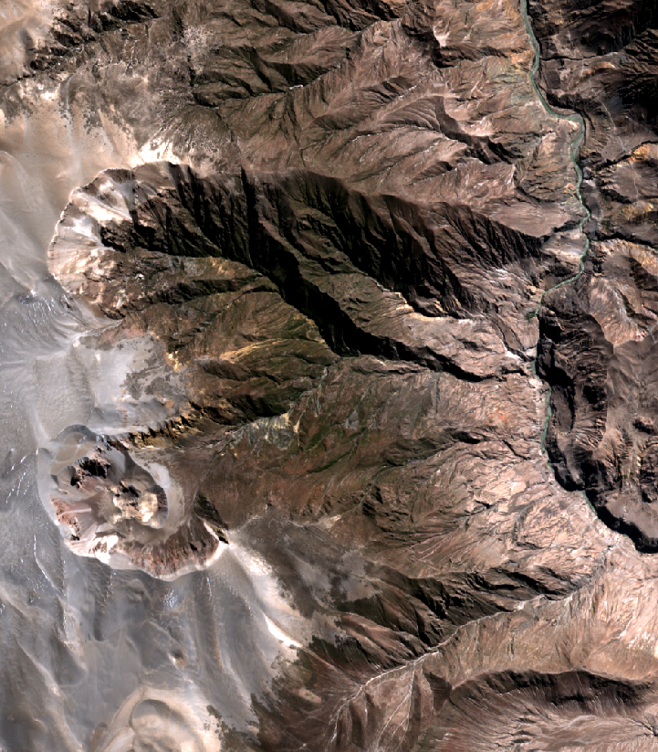
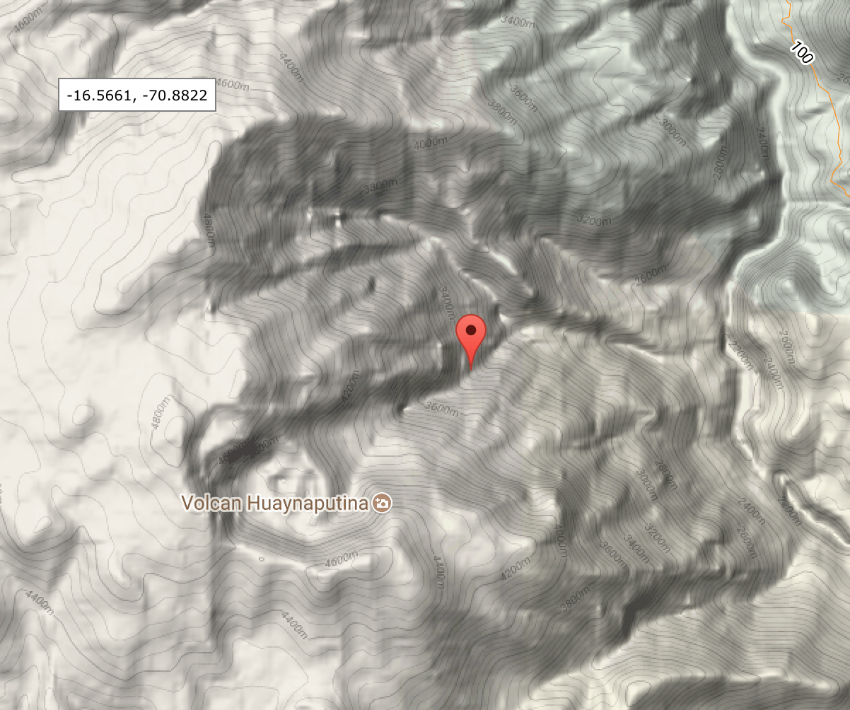
The missing mountain

Google 3-d map. The vents of the eruption have been identified as in the southern of the two rim craters. Click on image for full resolution
There is one confusing aspect about the large proposed DRE. The two craters that date from the 1600 eruption are rather small. They are sitting on the edge of a horseshoe-shaped caldera which is argued to be an ancient crater, of preglacial age. Where did the 10km3 DRE come from? One would need to postulate a 3 kilometer tall edifice above the rather small two craters. But there wasn’t a large mountain here. Before the eruption, according to Vazquez de Espinosa it was a low ridge sitting on a mountain range and it was apparently not even recognized as a volcano. It is hard to see how the explosion could have removed anywhere near 10 km3 DRE without creating a major caldera. On the other hand, the descriptions, the devastation and the ash layers clearly show that this was a large eruption.
The 3-d image shows the two craters, the northern one with a deeply eroded channel to the river, and the southern one smoother with a central cone. The name Volcan Huaynaputina is attached to this cone. It still has fumaroles along its rim; the gas comes out at a temperature of just under 80C, and with a pH of 5. The river valley to the east (Rio Tambo) is quite pronounced. It is very deep and wide and provides a perfect channel to collect volcanic ejecta, to be carried off to the south. The northern and southern crater open to a horseshoe structure which forms a scar on the side of this valley. The southern (half) crater is often assumed to be the site of the eruption, and the horseshoe and northern crater appear to be an older caldera.
Let’s assume for the moment that this caldera isn’t ancient but was entirely formed by the 1600 explosions. How much DRE could it have provided?

Looking into the crater. Source: http://ovs.igp.gob.pe/volcan-huaynaputina
The topography shows how extraordinary this area really is. The top rim of the caldera is over 4800 meter. Only in the Andes could this be viewed as a ‘low ridge’! The river to the east is at an altitude of 2200 meter. That is a drop of 2.5 kilometer, over a distance of 7 kilometer. Perhaps you thought the Grand Canyon was pretty good. This one unassuming river valley is a third deeper!
The central line of the caldera runs about 550 meters below the north ridge. I measured this along a line parallel to the north ridge, starting from the middle of top crater and running towards the river, and the height difference is quite consistent along this line, all the way to the river. Assuming we lost this much material over the entire caldera, 7 by 3.5 kilometer, that gives me a total hole of 13.5 km3. Bingo! That is the right size! If the eruption did not just form the two individual craters, but blew out the entire side of the river valley, it could explain the large DRE. Now we are talking. This would also explain the pre-eruption description of a ‘low ridge on a sierra’: the 4800 meter high ridge would have been the ridge, without the extreme and steep drop on the east side. (However, given the confusing text, it is entirely possible that this description refers to the wrong mountain!)
Explore the area at high resolution (opens in a new window)
On the other hand, the northern side does look deeply eroded: can it be that young? If it isn’t, than it will be difficult to explain as high a DRE as reported. In that case, a DRE of around 5 km3 would be more plausible. The answer is probably in the middle: the mountain was a bit higher than implied by the ‘low ridge’ description, and the eruption didn’t eject quite as much DRE as claimed in some papers. Research has not yet delivered the definitive story.
Wider impact
The eruption destroyed a number of villages, possibly through the pyroclastic flows following the river valleys, and it is believed that over 1000 people died.
But there is evidence that the impact spread much wider. Tree rings in North America from the year 1601 are very narrow, and they indicate it was the coolest summer over the period 1600-2000. Scandinavia also had very narrow tree rings. Summer snowfall was reported in China in AD 1601. There are also several reports that the Sun during 1601 lacked strength, reports coming from Iceland, Scandinavia and Central Europe. In Lucern, this faintness lasted from January 1601 until the end of July 1602. (However, a similar faintness was reported there in 1599 and attributed to peat fires.) The description from Iceland states that in the summer of 1601, the sun was pale and the sunlight was so faint that shadows were not cast; the sky appeared cloudy and pale even when no clouds were present. This indicates a sulphate layer, which given the extent and duration was likely stratospheric. (An Italian record just complains about the sky being overcast most of the time. It is not clear whether this is weather or sulphate.) This volcanic winter is often attributed to Huaynaputina.
The claim has been made that the disastrous Russian famine of 1601-1603 was also a consequence of the eruption. This idea was resurrected in a Nature paper in 2008, at which time it received worldwide attention, but in fact the first person to point out the possible relation was Friedrich Schnurrer already in 1825(!) (although he did not have the name of the volcano, and only knew it was near Arequipa). This famine is not well studied and few historical sources are available. The estimate that 2 million Russians died (a third of the population) is an extrapolation from a mass grave in Moscow and must be viewed with some caution. The famine was certainly a very bad one, and affected not just Russia but also Latvia, Ireland, and Iceland (here mainly in 1603 and 1604). In Finland, 1601 and 1602 were called the ‘Years of Many Deaths’.
The summer of 1601 had been poor; the killer blow was a frost mid-August which destroyed almost the entire Russian harvest. This frost also affected China, where it is dated to Aug 22 and 23, destroying the crops and causing massive famines. The spring of 1602 was fine, but the summer was not and summer crops failed again. The rye harvest was ok but the barley and oats failed. The problem was made worse by landowners who forced the peasants to pay the full dues and taxes, even when there was no income or food. (Another commenter at the time, with perhaps a more conservative approach to social welfare, stated that the problem was made much worse by the generosity of the tsar who gave money to the poor, so that farmers abandoned their land and rushed to Moscow to collect their ‘denga’ per day.)

Russian winter
But how strong is the connection between the severe problems of 1601-1603 and the eruption of Huaynaputina? The lack of sun is typical for a volcanic haze. But this haze began almost a year after the eruption and that is a very long time delay. For Tambora, the eruption was in April 1815 and the haze was seen during the summer of that year, not a year later. And the amount of sulphate from Huaynaputina, although high enough to have some effect, was significantly less than Tambora, so why would the effect be so strong and starts so late? It is also strange that, although the sulphate would have been mostly in the southern hemisphere, all the records of a faint sun are from higher latitudes in the northern hemisphere. But the biggest issue is the time delay: why was there no report of a volcanic haze for 1600 itself? It almost appears as if the eruption is dated to the wrong year. One paper suggests that under some conditions, it can take over a year before tropical stratospheric aerosols to find a way north. But this does not explain much, as by that time much of the aerosols would have dropped out and the resulting haze would have been minor.
In the list of the largest volcanic eruptions of the past 2500 years from Sigl and collaborators, Huaynaputina is ranked number 15 based on climate forcing (drop in sunlight reaching the Earth, which takes into account the sulphate). However, the temperature drop in 1601 is ranked number 2 over this period, just behind Tambora and just ahead of the devastating eruption of 540. This seems quite a discrepancy.
A closer look

Antarctica ice core measurements from Law Dome: Rubino et al 2013, Journal of Geophysical Research, 118, 8482
A very surprising change happened in the atmosphere around the same time. Analysis of air trapped in the Law Dome ice core (Antarctica) shows that there was a sudden drop in CO2 levels, by 10 ppm. The cause of this drop is not clear. A chemical reaction inside the ice removing the CO2 seems unlikely. It does not appear to be volcano-related, as the much larger eruptions of 1257 and 1453 show no such effect. Suggestions for the cause in the literature are a massive algae bloom in the oceans, and reduced CO2 return to the atmosphere from seasonal plant growth. But it might be as simple as a change in the wind on the polar plateau. There is an annual drop of CO2 levels of around this amount, as seen in the Keeling curve, with a minimum around September. If the polar winds failed apart from this time of the year, the ice core would measure the minimum each year. Something had changed in the weather. The drop seems to have started before 1600.
Let’s have a closer look at the weather. Before the eruption, between 1591 and 1600, in western Europe every winter had been too cold, and six of the ten were severe. The weather was so cold that in Burgundy in most years the wine harvest could only be done in October. 1599 was a warm year, but after the many failed harvests there still was hunger, and in 1599 bubonic plague began to spread again. Against this backdrop, the winter of 1599/1600 in western Europe was exceptionally cold, with the ice in the Dutch waterways almost 1 meter thick. Even at Easter there was still snow in Paris and England. The summer was warm, but it was followed by yet another severe winter, perhaps not as cold but very long. The next winter again was cold but with more milder periods.
This was the depth of the Little Ice Age and the climate had worsened considerably. Agriculture hadn’t yet adapted to the shortening growing season: what had been reliable crops before had become marginal. The period 1590-1605 was disastrously cold in Europe. This downturn started long before February/March 1600. And even the exceptional winter of 1599/1600 can’t be blamed on Huaynaputina as the eruption only began in February. The cold peaked in Asia, Europe and North America in 1601/1602: this could still be acceptable as Huaynaputina-related, as Tambora caused its cold summer in 1816, a year after its eruption. But for the onset of the cold weather, Huaynaputina has an alibi – it wasn’t there. Did it make things worse? That is possible, but based on the sulphate loading, only a relatively small effect might have been expected.

Sulphur in the NEEM ice core in Greenland. Data from Sigl et al 2015.
There is another point to be made. The Greenland sulphate levels seem a bit high compared to those in Antarctica, at least for a southern eruption. Looking a bit harder, it turns out that the Greenland sulphate spike is a double event, separated by a year, with the second peak slightly higher than the first. This is shown in the plot, using data from Sigl et al from 2015. I have shifted the dates of the Greenland core back by 1 year as that seemed to fit rather better with the climate record: an error of 1 year in the layer counting is not impossible. The second ice layer includes some ash that cannot have come from Peru although the origin is not known (Zielinski 2000, Quaternary Science Reviews, 19, 417). The haze reported from various locations in Iceland, Scandinavia and Central Europe lasted from early 1601 to mid 1602 which is (now) coincident with the second peak. Both suggest there was a second volcano involved. For the first sulphate peak, the sulphate signal is about equal between Antarctica and Greenland, consistent with a tropical eruption, i.e. Huaynaputina. For the second one, the Greenland peak is three times stronger than the one from Antarctica. This makes the second eruption a northern hemisphere one, and if the strength purely depends on the distance, it puts the volcano at about 45 degrees North. We don’t know of any major eruptions at this time, only some minor ones. At this latitude, the main options are Kamchatka, Aleutia, Cascades, and Iceland. Iceland can be excluded, but an Aleutian volcanoes is a real possibility. This second eruption, if this hypothesis is correct, was large enough to cause a volcanic haze in Iceland and Europe, and it went off at a bad time. When conditions are marginal, it is easy to cause disasters so perhaps the eruption wasn’t that large. But if this was a larger eruption, it is a concern that yet another major (VEI6) eruption may be missing from the historical records.
Huaynaputina was a big eruption and it caused havoc in the local area. But the accusation that it is responsible for the largest number of fatalities of any volcano known does not stand up to scrutiny. The real perpetrator was the Little Ice Age, assisted by another volcano. Huaynaputina was a victim of mistaken identity. It was like Dreyfus, falsely accused and wrongly convicted.
This leaves one question to be answered. Where is the culprit of the mystery eruption in early 1601? A crime has been committed – but the criminal is hiding, maybe in plain sight, leaving innocent Huaynaputina as a victim of a bad press, and of a miscarriage of justice. J’accuse…! Let Zola once more write a Lettre a (nouveau) President de la Republique. It is time to rehabilitate our greatest Inca warrior.
Albert Zijlstra, June 2017


Of course, just scrolling through the Andes on google earth, the caldera count there is pretty darn high
Outstanding Article, Albert! Now to ruminate about it.
Came home from Peru and a trip including Arequipa twoo weeks ago and agree. The area is breathtaking for its steep monutains and for the thin air. I wish I had read this exciting post before going there!
Bardarbunga is going for it. Three M3’s in quick succession, and a series of M2’s
The EQ map shows quite a neat “trail” of quakes between Bardy and Oraefajokull via Grimsvotn and that V-shape up to Askja. Not quite what you think of when it comes to volcanic patterns! 😀
I have seen this pattern for a long while. I suspect that there is a connection to Oraefajokull via Grimsvotn. Anyways Iceland is full of these geological links.
According to GVP data, Hekla had a VEI-4 in 1597 and Nevado del Ruiz had a VEI-4 in 1595 (Arenas Crater). Suwanosejima Shows as a VEI-4 in 1600. Additionally, there were 10 VEI-3 and 12 VEI-2 listed in the 10 year period from 1590 to 1600.
My gut feel is the the Junge Layer was probably well loaded during this entire period and carried a high background aerosol content. 50 months is roughly the stay period before sulfate levels return to pre-injection concentration.
(All of the VEI-3s and 10 of the VEI-2s are listed as confirmed.)
Side note: Momotombo – VEI-4 → 1605. Six others are listed with no VEI specified for 1600. (but show as confirmed.) {Izu-Oshima, Ebeko, Akan, Alney-Chashakondzha, Soufriere Guadeloupe, Calbuco}
But VEI-4s don’t really make much of an impact, even a few together. We had 9 between 2008-11 and there was no noticeable difference in sulphate levels. I think there would need to be several VEI-5s to cause a significant collective aerosol increase.
And that points out another issue with the VEI scale. A relatively persistent but low specific energy eruption can crank out a 4 without hitting the troposphere. A high energy but short duration one can nail the stratosphere but come out as a 3. The latitude of the eruptor and the season can have a strong influence on whether the stratosphere receives a significant SO2 pulse or not. Failing direct injection of SO2, all that is left is diffusion across the tropopause. I don’t have a clue about what that rate is. It’s also the mechanism that I think Carbonyl Sulfide takes in order to get there. It is fairly long lived in the troposphere and is part of the sulfur cycle, but is short lived in the stratosphere where hard UV can dissociate the molecule and allow it to form sulfate and contribute to the Junge layer. (aerosol layer)
From an old post:
Note: The vertical arrows denote general circulation. The actual latitudes depend on where the prevailing weather systems are at. For example, the double upwards arrows are where ever the inter tropical convergence zone (ITCZ) is at. Hurricanes can top out very near the troposphere in height, and Pinatubo’s main event (34 km ash cloud) went off right in the middle of a tropical system. (Typhoon Yunya) There are two ways to look at that. One, Yunya possibly helped in transporting the SO2, two, the intense moisture content would act to mitigate the SO2 by scrubbing it out. Either way, Pinatubo was still just bad news all around.
Was there any VEI 7 eruption around 1600? VEI 7 eruptions are known to disrupt the weather patterns around the globe, causing failed harvests and widespread famine.
Just proves how little we actually know past eruptions, and how recent it is that eruption records first began to paint a truly accurate picture of global activity! Anyway, for the DRE volume of this eruption, if we go for the middle-ground figure of 7.5km3, that would give an approximate bulk deposit of 20km3, which matches the data, and it makes it pretty much the same size as the Krakatau eruption. Interestingly, this eruption is Peru’s only major explosive eruption in historical time, and as a decent VEI-6, means that this one eruption ejected more material than probably every other historical Peruvian eruption combined!
It is so true. In fact science is still trying to discover the culprits of 540, 940 (other than Edgja), 1258, 1450s (other than Kuwae), 1600 and even in the early 1810s (the earlier one other than Tambora).
A volcano in Alaska in 1601 would be a good candidate but then I would expect to see many haze reports from North America. The fact that we do not have this, makes me think that the eruption was near Europe. At near 45ºN there is a highly volcanic area not yet mentioned, and also little studied: the Azores.
The Azores had some caldera forming events around the 17th century so there is a change that one of these caused the haze in Europe.
The other candidate would have been Iceland, but barring a highly hidden eruption in the north of Iceland or in Vatnajokull (still a possibility in my eyes), the Azores are the most likely candidate. Grimsvotn would have been my number 2 candidate.
Not a whole lot of people writing stuff down in North America in 1601. Talking about it. Yeah. Dunno if oral tradition has any mention of it.
Yes, I did look for records from North America. But the exploration and colonization had not yet progressed much. The westerners lived mainly in central and south america. A few people lived in Florida, but the UK colonies were founded after 1600. I could not find anything about Indian (oral) records. The Azores are perhaps a bit far south to reach Iceland, but I don’t know that.
Roanoke was found abandoned August 18, 1590. But they were too busy disappearing into history to write anything down.
“William Strachey wrote that, at the Indian settlements of Peccarecanick and Ochanahoen, there were reportedly two-story houses with stone walls. The Indians supposedly had learned how to build them from the Roanoke settlers.”
Ok, that explains the eventual lack of records.
Anyways, an eruption in the Azores would have left historical reports in Portugal, Spain and France, and we have none of those, so this makes it a less likely candidate. But it would have reached Iceland too, when storm systems pull south wind into Iceland.
Iceland is still a possibility. Because things were pretty badly recorded by that period of history (16th and 17th centuries).
A easy way to find the culprit, for this, and for any other mystery eruption, is to take ice core samples from the west and from the east side of Greenland ice cap. An eruption coming from Iceland would leave significantly thicker layers in East Greenland, while an eruption located in Alaska, would leave traces slightly higher in west Greenland.
That is a good point.Greenland is probably not big enough to show such a strong effect but there are also some ice cores from Alaska. I had a quick look at Yalcin 2007, but decided that the dating of the pre-1700 ice seems a bit uncertain. They show nothing at 1600 (absolutely nada )but a very big event around 1630. I’ll keep looking
News from Katla research. A large eruption was dated to 822 or 823, based in uncovered tree rings and the 725 solar flare event. It must have been a very large eruption to flatten such a forest. “Normal” VEI4 and even VEI5 (e.g. 1918) eruptions did not destroy such forests around Katla.
These are news from 2 days ago, sorry if it has been already reported here.
http://earthquaketrack.com/quakes/2017-06-30-13-33-44-utc-4-8-10
Earthquake off coast of Scotland and Norway. Widely felt across Scotland.
Is this a submarine landslide?
I know of no faults in this region.
Storegga tsunami event occurred in a location further north, also at the edge of the continental plateau.
Could here be any risk of a landslide-induced tsunami event, even if a small one?
The seafloor is pretty flat’ish in that area, so I doubt it was a landslide, still possible though.
I read a speculation somewhere, that it might be an empty oil field which collapsed/roof caved in on, no idea of that’s possible though. There have however been fractures and stuff in the area from oil related industries.
More stress maps of Europe http://dc-app3-14.gfz-potsdam.de/pub/stress_maps/europe.html
It was felt in Shetland https://twitter.com/ShetlandWild/status/880787790568579072
I think it began when the UK was discussing moving closer to the Norwegian model of EU non-membership. That caused stress.
BTW, there is an old fault somewhere there dating from the opening of the Atlantic Ocean. It is one of the places where the Atlantic tried but failed to open, before the current MAR formed.
Thinking Storegga slide. If something similar happened today, would it be detected before disaster? Seismic signal that could be interpreted as a gigant underwater landslide? Just a thinking game!
There’s the Hilina Slump in Hawaii which has the potential to slide, but it is monitored, so I guess they’d know before the disaster struck.
I’ve personally always wondered what would happen if a large portion of the Mariana Trench collapsed.
If I remember correctly, The last time that slump moved appreciably was in 1975.
Is this the slowest earthquake you have ever seen? The image shows the extension of the Mauna Loa caldera. It shows the gradual increase over the past year. but since the big quake on June 6, it has been oscillating, with a period of about 10 days.
Something similar was seen in St Helens during its 2004-2008 eruption (https://volcanoes.usgs.gov/vsc/file_mngr/file-79/Andersonetal_jgrb16449.pdf) although there the period was around 5 hours. But Mauna Loa is a much bigger volcano and everything goes a lot slower.
The cause is not entirely obvious, but most likely (I think) it is magma pushing against a plug that contains it where everything got out of balance. The plug is quite shallow (a few km), otherwise you wouldn’t see it so much at the summit. The pressure goes up, and after a while the mountain responds by extending. This lowers the pressure and the mountain contracts. The lower pressure sucks in a bit more magma from the conduit below, pressure increases again, and the cycle begins again. Because the plug is so big, it takes a while for the mountain to respond which is why it starts to oscillate. The period of 10 days may come from how long it takes the magma to travel in te conduit from the deep to the shallow magma chamber.
How it got started – perhaps the mountain sagged a bit after the earthquake. That extended the summit crater, and that lowered the pressure in the magma chamber, so the caldera contracted again at the same time as a bloc of magma moved up the conduit, in response to the lower pressure.
Phreatic eruption at Dieng Complex, Indonesia. Surprisingly, the alert level hasn’t been raised.
Daily Mail have reported sadly two people have died.
http://www.dailymail.co.uk/news/article-4659234/Ten-people-injured-volcano-popular-tourists-erupts.html
Fantastic article Albert!
Your best so far in my opinion (and that says quite a lot since you write them all well)!
I have for a long time had a beef with Huaynaputina since it is just to small to cause a large climate crisis, and as you point out, it was the little ice age that caused the famine, not a medium sized eruption far away.
Intriguingly enough the little ice age is not of clear origin. The sun, wind circulation shifts and the golf stream changing has been blamed among many things. Personally I prefer the shift in the golf stream due to the distribution of the climate change.
I like that you pointed out a second major volcano.
One thought that is almost perverse is if it would turn out to be Bogoslof that did have an eruption. We do know that a prior eruption had pushed up a 450 meter high lava dome (yes, Bogoslof used to be a sizeable island before). That island dome blew away in 1796 in an explosion that is most likely under-rated.
It is at least a likely culprit for both being able to have large eruptions, and for blasting away all evidence of what it is doing.
Even if Bogoslof would turn out to be the wrong volcano I suspect that it is the correct region of the aleutians. The neighbours are also known heavy hitter such as the brutal Okmok.
My favourite suspect is the youthful caldera volcano of Herbert near to Mount Cleveland. It is yet another of those majestic caldera volcanoes in the aleutian islands that nobody has hauled arse and checked out. Study factor = Zero. But on looks in closeups it has gone caldera in the last 2000 years. And it is in the big hitters area.
https://volcano.si.edu/volcano.cfm?vn=311220
Well it is quiet an “empty” caldera and the area of its fumaroles is hardly altered chemically, so it could be possible, in fact the caldera floor looks very similar to Tambora’s. I think it’s the only significant Aleutian volcano with a caldera that has no information collected about its eruption history. I did email AVO about it a few months ago and they said it was definitely formed by a large explosive eruption. I am a bit surprised that no samples have been collected from Herbert, or Cleveland (which I would’ve thought would have a full monitoring network by now, what with it being so persistent over the last 12 years) or Carlisle either; there have been quite a few field trips out there in the last few years. Maybe we could kidnap a guinea pig to get us a sample! xD I’ll email AVO again and put your suggestion to them, let’s see what they say. Anyway, are we somewhat close to finding culprits for any of the other massive eruptions without an identified source? For the big 1808 mystery, I think a proper good look at the ridiculous number of volcanoes along the Chile/Bolivia border could give us an answer!
Thanks Carl for the kind words! You have to decide whether the evidence for a second eruption is convincing. Irpsit thinks that an Icelandic eruption around that time cannot be excluded. Or Jan Mayen? But I like the Aleutian chain best as this could give a widely distributed sulphate layer in the north, without a clear point of origin. Bogoslof would be one candidate. There is a tephra layer in sediment in Alaska from around that time, possibly linked to Redoubt, but I am not sure how big it is.
The origin of the Little Ice Age is, in my opinion, the general cooling trend over the past 6000 year. The fluctuations, such as the coldest decades, will be related to ocean currents, but they are made so bad because the average climate was getting colder. The cooling is due to the Milankovitch cycles. An interesting question is what ended it.
Both Iceland and Jan Mayen is out of the question I am afraid. No traces of such a large eruption at Jan Mayen, and the Icelandic records are just too good for them to have missed such a large eruption. It would kind of have stood out.
And the words was just pure honesty! 🙂
I am once again going back to the golf stream for the reset that ended the cooling.
The winter 2009-2010 was a glimpse of what a disruption of the circulation pattern across the North Atlantic causes over northern Europe. The UK instead of a rainy winter had a deep freeze.
During the Little Ice Age, there was much colder climate during winter in Europe, with severe freezes over UK and Holland and abundant snowfalls in Portugal and Spain. The jet stream was passing through Spain into Italy, instead of the usual UK to Norway path. Summer were not bad, except during volcanic disruptions. But winters were very severe quite often in certain decades of that period.
It must have been a change of the Azores high, the jet stream path, and the Gulf Stream path during the wintertime.
What started the little ice age?
1) there was a cooling trends since mid Holocene
2) solar activity was very low
Both resulted in changes in ocean and air circulation in the North Atlantic
What ended the little ice age?
1) Increasing solar activity
2) Industrial revolution
Both again, resulted in changes in ocean and air circulation in the North Atlantic
Love the Azores high. When it’s dominant, most of the tropical systems drill a path up the east coast rather than the Gulf. Bermuda Highs push them down through the Caribbean.
I agree apart from the solar activity. I do not buy that such minute changes in solar output can drive large variations on Earth. Have gone through the data myself and decided the correlation of cold weather and the Maunder minimum was not statistically significant. Neither can the warming be attributed to the solar activity. The industrial revolution is a good bet for causing warming though.
I had heard (read) it speculated in the science press that the mini ice age was an expected phenomenon through the onset of the upcoming glacial period in the Milankovich cycle. Over time, more of these cold periods would be expected as the earth slips into the ice age. (Speculated = arguing to and fro in a barrage of peer-reviewed papers….)
That said, there is still much science discussion on the length of the current inter-glacial warm period; that this one may actually be one of the longer ones rather than the “usual” 10,000 quickie.
I think the jury is still out on most of this. Regardless, we appear to have well and truly knobbled the whole system, so the jury is not only out, it”s packed its bags and gone on holiday.
Albert, it is way to early for the industrial revolution to have any effect. The amount of released CO2 is just to low.
CO2 concentrations
The industrial revolution was in the period 1760-1820. From 1850, CO2 began to rise notably.
Temperature
Temperatures stablised from 1850, started rising after 1900, and the current rapid rise is from 1980.
There is a good correlation between CO2 and temperature as far back as 1850. However, initially it may well be that the relation was indirect. The soot produced by the factories may have been more effective than the CO2.
Methane should also not be forgotten:
My point was that the industrial revolution did not affect the little ice age. It most likely died out for non androcentric reasons on its own.
Here is a reconstruction of holocene temperatures. Note that the variations at high latitudes were larger, and that the southern hemisphere did not show holocene cooling, which in fact is one of the things that points at Milankovitch cycles being responsible.
And here you can see previous ice ages. The interglacials tend to be slowly cooling, with a sudden drop into the true ice age. That is more or less what we had in our current interglacial, until we upgraded to global warming instead of cooling. (This plot is reversed compared to the previous one. Sorry about that.)
(My opinion is on record: a bit of global warming was a good thing. But we shouldn’t push it much further or we will have serious problems.)
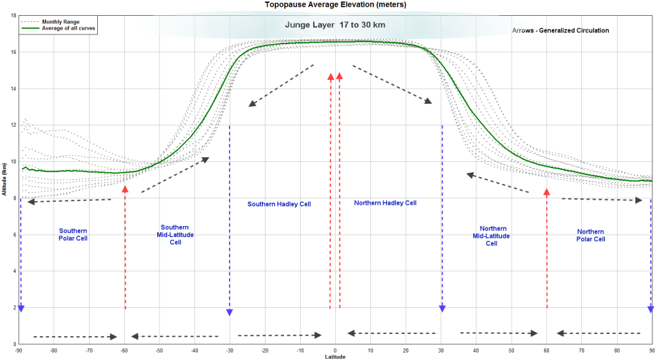
Now, since we are pondering potential volcano culprits, remember that the latitude of the suspect has a strong effect on whether it can reach the stratosphere or not. Key to that is punching the ash cloud past the tropopause.
This is essentially a synoptic plot showing the elevation of the tropopause at various latitudes and times of the year. This is an AVERAGE look at the elevation of the tropopause. Weather systems and actual conditions will dictate if the elevation is accurate at the time. Data source is from the cited entity. The graphic is a rip-off from an old post of mine. (used with my permission)
Interesting thing I just noticed. The “Roaring Forties” is a well known phenomena in the southern hemisphere. Notice that latitude has a pretty flat gradient for the whole year… meaning that it is going to be fairly persistent all year long.
And this is just me regurgitating another old plot since I was already doing so. The data hasn’t changed as far as I know and it may be of use for those searching out old eruptions. Evidently, the northern hemisphere volcanoes are more active than the southern ones. Dual spikes (north and south) are typically the tropical systems. And again, remember that whatever the prevailing weather was doing can drastically affect where the SO2 load winds up at.
I remember this chart but, looking at it once again I’m curious over the rise in S02 in the northern hemisphere in recent times. Presumably this is human pollution?
Yes, it is due to human polution. Mainly from burning coal and oil. Notice that it is mainly in the northern hemisphere. And yepp, that is severely bad news for lakes and forests.
This sulfur level already equals some of the most recent volcanic winters like Laki, though not as much as 1258 or Tambora, but its heading in that direction.
This means the man-made SO2 already contributes to perhaps -1ºC of temperature lowering due to aerosols. This has interesting consequences. If we remove human activity suddenly, then the CO2 induced warming of +1ºC would jump suddenly double to +2ºC.
Reminds me of an eruption goose chase that happened here a few years ago. Someone spotted a seemingly huge SO2 plumes on one of the satellites. Slap dab in the middle of Russia, roughly in the Siberian traps area. Further looking revealed an industrial production oriented city and not a volcano. It was nowhere near as large as Beijing’s SO2 output, but it was large.
Earthwinds, config for SO2 display.
Sort of makes you appreciate the low sulfur fuel standards.
Less ‘the north is more active’, and more ‘the majority of the land mass on the planet is in the north, thus the majority of the volcanoes are up there’. NA, Asia, Europe, Iceland, most of Africa, some of SA, India, etc. Most of everything that matters is above the equator, and the southern hemisphere is mostly water. Yeah, Antarctica, I know, but most volcanoes down there are under a mile of ice, so aren’t exactly going to cause problems except in extreme circumstances.
*sigh…
http://www.news4jax.com/news/florida-man-sits-on-gun-shoots-self-in-penis-police-say
He’s not going to jail for shooting off an appendage, but for possession of a firearm by a felon.
At least he can still collect his Darwin award. Most of those are posthumously.
could still reproduce (by ivf) – so fails to achieve darwin award I think
Still a severe setback i the “selection of the fittest”.
I wonder what the manufacturer will have to pay him in damages for constructing a gun that is not penis-safe.
My guess is that it will all come down to whether or not it had a warning to not sit on it or not. This is how some of the more bizarre warning labels come into existance. “Do not use toaster in shower” etc…
because you will get soggy toast..
It gets worse. According to the History Channel, George Washington fought at Gettysburg. Thats,quite an accomplishment when you concider that he had died around 64 year before that battle.
Just means he showed up 65 years early for the battle. A sneak attack before the other side had a chance to organise themselves. Guaranteed victory.
… but, it adds credence to the “Abraham Lincoln vs Zombies” movie idea.
Prickly problem. IConfirms the gun lobby’s argument that if more kindergarten kids were issued AK47’s we’d have less of a testosterone problem.
/Seems to be a comment in regards of Lurkings “Shot thyself in thy private member” comment up above. Admin
Sorry. Should have posted as a reply to Lurk’s comment.
I would move it, but doing so risks messing up the comment flow pretty badly.
My contention is that any and all weapons are tools. Each tool has a designed and intended use. Where the failing is at, is in people not being trained about proper tool usage. Using a hammer as a screw driver is just one example. A hammer and a screwdriver are both intended to put a metal spike into something, but neither one operates in the same manner.
A bomb can be used as a tool. That doesn’t mean everyone should be allowed to have one. Acid attacks are becoming an increasing problem. The obvious policy is to limit the strengths of household acids for sale, and only professionals are allowed to used the highest strengths. Some major chains are already doing this. Why would guns be any different?
Anyway, lurking knows were we agree and disagree on this!
My point is that tools should be in the hands of people who are either professionals or trained amateurs. Nobody would say that putting a chainsaw in the hands of an idiot is a good idea… and guns are potentially more dangerous than those.
I am happy with people having guns, after going to a mandated usage course and passing checks.
Just noticed this headline in a rag that makes the Daily Fail look sensible. Looks like poor Jon was culled for news. http://www.dailystar.co.uk/news/latest-news/626004/Iceland-Katla-volcano-eruption-Europe-UK-flights-ash-cloud-Eyjafjallaj-kull-earthquake
Jeebus, one has to think before one writes… And yes, Daily Star is far worse than Daily Mail.
I got as far as laughing at the title before closing it.
You should have kept reading. One photo is captioned with this literary face-plant.
“Katla has a Volcanic Explosivity Index (VEI) of between 4 and 6 on a scale of 0 to 8”
Think about that for a moment. A volcano, that IS NOT ERUPTING… has a VEI assigned to the eruption it is not currently having?
So what happened to all the VEI 0-3’s that Katla is ‘currently’ having by not erupting? If it does have an eruption could it reach 8? Maybe if it simultaneously didn’t errupt with a VEI 3 and errupted with a VEI 8 we’d have a VEI 11 on our hands! We all know what happens at 11…
This is Spinal Tap…
https://youtu.be/N3L4EZwmRrA?list=RDs9F5fhJQo34
The frustrating bit is that Jon is not an alarmist. He’s really cautious about not hyping a volcanoes potential to erupt.
Well, we need good news right? Hekla dropped off the charts tonight.
Happy 4th to you. I am happy tourist survivour of your country – but did not dare go souther than “somewhere in Virginia”. Also to DC but DT was not at home that day. Your Interstates should ban trucks from outer most lanes … been there, seen that, in pooorring rain, it aint no fun!.
Am thinking of going Las Vegas/Flagstaff/Death valley/arches NP next spring. Should I be worried? I thought not but ….
Well, the big geological thing going on there you can’t see. There is a “lithospheric drip” in the death valley region. If you get a chance, go check out beringer crater. Impressive critter in its own right… and it was one of the smaller impactors.
OT; I don’t have back channel acess from my phone, but I predicted this there. The recovery location is just around the corner from where his board was found. It’s a tourist oriented fishing pier next to the bridge. (Pay for access). You can sit out there and fish all night long if you wish. As long as you keep your receipt you can go pick up ice or more bait and drive back out to your spot.
http://wkrg.com/2017/07/04/breaking-body-of-missing-paddleboarder-found-near-pensacola/
Berniger is a bit touristy, but what was surprising it was hotly debated for years that it was volcanic…
Do it if you can.
Also don’t forget to go “standing on the
corner in Winslow Arizona..”
They opened a valve on the Hekla strain meter, according to the annotation. The mountain itself is currently well behaved.
Perhaps they are letting off steam – quieten her down! 🙂
Really depends on the truck. Typically they stay over there until they come across some idiot with his four ways on creeping down the road. That is usually the hazard that makes them get into the “hammer” lanes.
Yes, we do have a lane rule, but it’s not ticketable. “Slower traffic keep right”. One that can yield a citation is the one mandating an empty lane between you and emergency vehicles stopped on the shoulder. If you can’t move over to give an empty lane, you have to slow to 20 mph below the posted limit. As a rule of thumb, most truckers apply this to any vehicle along the side of the road. Even though I’m an ex firefighter, I still appreciate the rule. The last thing you need when working an incident is an 80,000 pound Freightliner bearing down on you at 70 mph.
Jon is cautious, factual, and knowledgable. Sadly anyone can be misused in such articles. Katla is quiet now. Of course eventually it will erupt. The predictions are about when, not if. But it doesn’t seem imminent. Being Katla, it can of course suddenly erupt into a tantrum, so don’t take this as a prediction.
Vesuvius on fire (as pointed out by Neil and Clive in comments on an earlier post). No worried – surface fires only.
Daily Star to run a front page story about Pompeii/Herculaneum II in 5….4….3….
(Hi everybody)
Ha !
You’re probably right !
I’m sorry that comment went onto last week’s post. I don’t know why, but for some reason that’s the one that cropped up when I came to the website earlier today.
The really sad part, is that typically the media idiots resort to erroneous descriptions when talking about a volcanic eruption… “fire and smoke” usually wind up in their narrative. This time it actually is real fire and real smoke.
BIg bang inthe US. M6-ish earthquake in Montana. But after Carl’s warning, it avoided Yellowstone.
I am now waiting for the Yellerstoners to start jabbering about the end of the world anyway… 🙂
We are all BOOMED!!
I guess you have missed the latest pet theory out in the looneyverse. According to them Yellerstoned is not filled with magma, now it is molten carbon. I am just waiting for a certain president to rewamp it into a coal-mine.
Molten carbon?? Put an anode and cathode on either side and you got the biggest battery in history. Could solve all our renewable-energy-storage problems. Yellowstone saves the world!
Next, they’ll be saying it’s molten cheese and we’ll have a giant fondue to enjoy…
Do not ask me where they got the molten carbon from.
Or, I think one of them may have heard about the semi-molten carbonatite that underlays the joined platelet shards on the western part of the continent. It was actually a hypothesis in a paper published a while ago, and then the nutters ran with it screaming that the US is resting upon a layer of molten carbon… Sigh.
Not only that-it stretches out oh 300km
to Lincoln ,Montana.
This one is worthy of DR.Kuku:
https://www.yahoo.com/news/natural-disaster-5-8-magnitude-150301642.html
Read-Lewis and Clark Line-bit like the
OWL or Brothers lineament in this
are.
Not any thing to do with the regions
of the volcano that shall not be mentioned..
In case anyone hasn’t seen it, interesting article on the Salon site
http://www.salon.com/2017/07/05/volcano-forecast-new-technique-could-better-predict-eruptions_partner/
hi everyone this might help explain the little ice age aswell http://www.bbc.com/future/story/20170630-the-massive-volcano-that-scientists-cant-find.
Nice post, almost as good as a VC post but with less background data..
I had seen that. The eruptions at 1453 and 1459 seem fairly well dated, and 1465 is really too late for a significant haze. A blue sun comes from particles of around 1 micron in size and these can form from sand storms or smoke.
And since I’m off to Prague in the early morning.
Here is pompous beer drinking rock at it’s finest.
I think Lurking will like it.
Jane Espie’s Celtica, here live at Harley-Davidson Biker Fest 2016…
Funny. I’m sitting at seafood resturant t next to a Hatley dealership right now.
Thanks for the Celtica.
Love these fusions… Salsa Celtica… Mac Umba (particularly the “Bruhuhaho” album)…. and heading off in a slightly different direction, Omnia… This is the adopted theme tune for my shop which is called “Ravens”)
Sort of on the topic of mini-ice age and real ice ages, this just rolled off the science press:
http://www.geomar.de/en/news/article/sinkender-meeresspiegel-brachte-vulkane-zum-ueberlaufen/
“Falling Sea Level caused Volcanos to Overflow”.
Regarding the landslide/tsunami in Greenland the other day. Authorities have found yet another 1km wide area that’s at high risk of falling, as well hints that the entire mountainside, a strech of 5km is in potential danger of going down, if a new large rockslide happens(domino effect), as the entire area is highly unstable.
The first “potential new slide” that was found right after the event, has slipped 30cm in the last couple of days, and the villages of Nuugaatsiaq and Illorsuit (151 people in total) have been permanently evaquated for the forseable future. With Norwegian experts putting the danger of a new slide happening at 11.5 on a scale from 0-12.
Poor people, I feel for them.
Wonder why this. Is it deep permafrost that is giving up as the region warms up?
Mass wasting and fairly normal. As a rule of thumb, the more stunning a scarped landscape is, the more frequently you have wasting events. Terrain doesn’t get spectacular unless there is a fairly fast geological process going on. (In geological timescales)
Hawaii is a good example. Parts of those islands are always falling off… the same for El Hierro.
Half an island is still an island, but is half a mountain still a mountain?
Recalling Eric the half-a-bee, who was bisected accidentally by Monty Python:
Half a bee
philosophically
must ipso facto
half not be.
But half the bee
has got to be
vis-à-vis its entity
d’you see?
But can a bee
be said to be
or not to be
an entire bee
when half the bee
is not a bee,
due to some ancient injury?
New post is up!
http://www.volcanocafe.org/greip-gjalps-mysterious-sister/