
There was a lot going in the 1960’s. This was the time of the generation battle, where the children who had grown up in a time of austerity and a cold war, rebelled and looked for something different – exploring, ignoring the boundaries but never quite finding what they were looking for. Martin Luther King and John F. Kennedy were shaping the future, and paying dearly. East and West were fighting, from Cuba to Vietnam. Europe suffered through the terrible winter of 1963. Who cared about a volcano no one had ever heard about? Even if it was one of the largest eruptions of the 20th century?
Bali is different. This island of 4 million people has its own culture, and in fact was an independent kingdom until 1906, with a distinct culture. The island is not large: 150 km by 110 km. Most here is volcanic in origin, and those volcanoes, as elsewhere in Indonesia, are alive and active. Several are over 2 km tall. The highest is Gunung Agung, at just over 3 kilometer. The climate is monsoon, with a very wet December to April but little rain from May to September. Tourism is big business, and at times it seems most of Australia is here. It seems paradisiac. But when the fertile soil of paradise comes from volcanic ash, life is never totally secure. The eruption of 1963, little recognised in the rest of the world, brought devastation.

Three volcanoes are located in close proximity to each other. Furthest east is Seraya, deeply eroded with no intention of every erupting again. In the middle is sacred Agung, with Bali’s largest temple, Pura Besakih; the climb to the top takes about four hours from there. West of Agung is Gunung Batur, 2150 meter high, with its enormous, 25,000 year old caldera. Visible further to the east, beyond Bali, is Rinjani, site of the enormous 1257 eruption, showing that this area has history. Batur and Agung both are quite able to erupt. But while Batur does frequent but minor, Agung does dangerous. Its 1963 eruption was a particularly bad one.
1963
Although there had been fumarole activity in the crater of Agung, the mountain had not erupted since 1843. On 16 Feb 1963, with Europe shivering in its worst winter for two centuries, earthquakes began to be felt in Bali, although not strong enough to do any damage. Two day later, 18 Feb 1963, explosive activity began, minor at first. Lava flows were first seen on 19 Feb, one day after the first explosion, flowing through a gap on the northern rim. The lava had probably first appeared together with the explosions the dat before, but this had not been seen. On 20 Feb, a pyroclastic flow which reached one village. These were the first casualties. Rain caused some lahars over the next days.
A video of the early days of the eruption is available on this icon of the 2010’s, youtube:
Over the next four weeks the lava kept flowing although the amounts were not huge. The lava flow reached a length of 7 kilometer. It was 1 kilometer wide and over 50 meter thick; the volume over the next three weeks is estimated at 0.05-0.1 km3. The explosions now began to strengthen, and ash was rising as high as 3 kilometer above the peak of the volcano. From March 8, explosions were becoming severe.

From Self & Rampino
And so the main event began. At 5:30am on 18 March, major explosions began, lasting for 3.5 hours. The ash fell as far as 1000 kilometer away, in Jakarta. One of my secondary school teachers once told me that while he lived in Jakarta, he had experienced volcanic ash – and I think that may have been this eruption. Pyroclastic flows came over the rim of the caldera. Rain coming after the eruption caused lahars. These flows even reached the coast, destroyed villages and caused many casualties.

Besakih temple, threatened by Agung’s eruption
This event took some of the pressure off. The source of the lava flow was cut off after it, and the lava flow slowly came to a halt. Lava refilled part of the crater but it did not overtop the rim again. After 18 March the explosions, although continuing, lessened in intensity and by the middle of May, the eruption seemed to be subsiding. But this was deceptive. On 16 May, there was another major explosion, lasting 4 hours. Again the pyroclastic flows came, and again there was major destruction, now mainly around the foot of the mountain. Two days later there was a larger earthquake, and more explosive events although not of the same size. The lava now stopped completely. After the end of May, the explosions became less, and although the eruption continued until 1964, from here on it was a minor one. But when the rainy season started, in November, the ash soaked up the rain, became unstable and started to move. This again lead to devastating lahars, and even more casualties. And near the end, Batur joined in with its own, unrelated eruption.
By the end of the eruption, over 1100 people had died and the economy of Bali had been devastated.


Numbers
During the first four weeks of the eruption, lava flows and explosive activity occurred at the same time from within the caldera. It seems problematic that these came from the same location; more likely is that there were several vents in the caldera, some giving phreatic explosions and one or more expelling lava. But no observations were made within the caldera. It was, after all, during the peak of the rainy season.
The ash of the 17 March eruption was blown to the west, covering all of Java. On the slopes of Agung, the layer was up to 50 cm thick, and it reached 0.1 cm in Jakarta. The ash of the 16 May was less widespread, and was blown mainly the the north where the layer reached 40 cm in depth. Much was blown out to sea, and some fell 175 km away on the island of Sempanjang. Pyroclastic deposits are found in the valleys on the slopes of the volcano but it appears they did not reach much into the low lands. Instead, the major damage was mostly done by the lahars, which was partly due to the fact that the main event occurred during the rainy season. In a way, this was a foreshadowing of what would happen later at Pinatubo, where the eruption coincided with a typhoon.
So how much did this 1963 eruption erupt? The ash layers are fairly well mapped, and summing everything up suggest that the 17 March event caused 0.4 km3 of ash. The 16 May event is less accurately mapped, but it is estimated at 0.3km3. This is fresh ash: the dense-rock-equivalent (the hole in the crater it left) is less, and this is estimated at 0.28 km3 in total. Adding the lava makes the total eruption 0.4 km3 DRE.
The precise cause of the event is not known, hampered by a lack of observations. The deposits show that two lava types mixed in the eruption. Self & Rampino suggest that older, andesite magma was already present, and that in Feburary 1963, new basaltic magma was injected into this reservoir. This resulted in lava filling the crater and causing the highly viscous lava flow. A second pulse of fresh magma high in volatiles caused the 17 March explosion. The magma became capped, but in May this cap broke because of the pressure from below, and a new explosion occurred.
Although the ash cloud was only reported to be 10 km high, it likely was much higher than this. The eruption rate makes it likely that it reached twice as high, 18-20 km. In fact, a year later a plane measured some ash from this eruption at 20 km altitude. Not only had the plume reached the stratosphere, some of the ash there stayed aloft for a long time.
After 1964, Agung went back to sleep, and the people returned to the local villages. The mountain would sleep for over 50 years. But now, a prince has come and kissed the sleeping beauty awake. A new injection of magma has taken place, and since a week there is explosive activity. I today’s event, like in 1963, the ash is reaching some 3 kilometer above the mountain, 6 kilometer above sea level. And again it has started close to the rainy season.
It is difficult to predict how this will evolve: If it remains similar to 1963, the next step will involve lava, which may be viscous and slow moving. However, eruptions rarely do copy each other. There are lessons, though, and they show that the biggest danger is not from the lava, and not even the pyroclastics. Once the rains come, the biggest danger is from lahars, coming down the river valleys. Following those valleys, they can reach far beyond the mountain.
Agung has history, and the history shows that this sacred mountain should not be taken for granted. The current eruption may end without much more activity: volcanoes do as they please and if we are lucky, the gods have now ben satisfied, the prince giving his marching orders, and the mountain allowed to fall asleep again. However, if it behaves as in 1963, this may just be the beginning and we could be in for a dangerous few months. Only time will tell.

Lahars covering a village, March 1963
Albert
Main reference source:
Self, S., & Rampino, M. R. (2012). The 1963-1964 eruption of Agung volcano (Bali, Indonesia). Bulletin of Volcanology, 74(6), 1521-1536.


Thanks Albert. A thorough and useful history.
I just tuned in to the Mountain Observation Post webcam to see Agung is coughing out a load of ash. I hope people are now well out of reach and cannot be harmed. This will be an interesting eruption to observe and see if it follows the 1963 pattern. If it does, then that helps Indonesian Volcs for the future.
I hope the local team get all the webcams up! Good luck, Bali and keep safe.
(NB Hobbes – this posted in IE11. Edge gave me the Invalid Security Token response.!)
Thanks Clive,
I’m not sure the support team have a clue what’s causing this issue…
Content edited out for violation of the Be Nice rule.
Snarks not appreciated.
/Owner
The VCMap is completely separate from the WordPress environment, therefore is not likely the cause.
This started with the last major update to Edge
Probably the over aggressive new security which has made several website glitch beyond belief
Do you know when the edge update happened?
Nope, the last major overhaul of Edge was done after the glitches started, mine updated 4 days after my first lockout.
Erm, what? I did not violate the rules. I just noted that the obvious place to look for the cause is the most recent change made to the site before the problem started being reported.
Found a clear video taken this morning local time 6:20 am
https://www.youtube.com/watch?v=7M766XE4hGE
Mac
That’s a goodun and a clear sky to boot. Certainly is the rainy season over there, forecast indicates that good views of the mountain may be limited for at least a fortnight, suspect early morning will be the best chance.
Webcams of agung:
https://www.youtube.com/watch?v=Gtf6iccnkHE
https://www.youtube.com/watch?v=islcMmfHHqE
1 minute photo, but frozen now,:
Thanks for timely post on Agungs previous eruption! Now, with this huge ash fountain, the drumplot is still very quite with slightly thicker line. Would expect more noise from a preatic eruption.
https://magma.vsi.esdm.go.id/live/seismogram/
Ultimately, the VEI for Agung will be determined by the scientists who go out and do the hard work of collecting and analyzing data.
Taking a sneak peak, we can get an idea of how it will tally up when it is all said and done with. Using two data points from Darwin VAAC about the ash cloud, and a bit of wrestling with Mastin et al, this is my take on how the eruption is going right now. It’s just starting to cross into VEI-2 territory. Current mass ejection rate is about 37.25 m³/second.
Yeah, it’s a neat plot, but the method can be off by a factor of 4 according to the Mastin et al document. So, don’t read too much into the plot. It’s still just a rough guess.
It is after all, based on a model. And models can get you in trouble. 😀
Tell me about it; I dated one for a while…
The seismograph is busy this (UK) morning, with lots of shaking and mini-quaking since about 6am.
https://magma.vsi.esdm.go.id/live/seismogram/
The ash column is impressive
https://www.youtube.com/watch?v=Gtf6iccnkHE
And after the first eruption, apparently Australia is in control of the ashes? It must be all those tourists.
https://www.yahoo.com/news/ashes-2017-england-verge-first-072900528.html
It seems only a tiny cupfull of ashes have reached Australia. The British have sent a team of specialists to help remove this fallout 😉
Unfortunately, they haven’t had much success so far.
(If you’re not into the mystical art we know as “cricket”, this will be lost on you 😀 )
Oh… And don’t forget to keep an eye on Oraefajokull… small cluster of quakes there again, including a couple of shallow ones…Ice quakes ?
Ice quakes are not listed together with normal quakes, so no.
In that case, they were very shallow….Near the bottom of the glacier.
Now much more noise on the drum plot. Obviously, they have changed the sensitivity and also the thin line back the last 12 gours or so, has changed and show a lot of smalltalk.. So, this is how an Agung ash eruption looks like on the drum. Wonder how it will look if lava starts mooving…
Hope the population got out in time… Any news on that?
I have not hear anything other than the BBC. It seems like the ash is worse on Lombok than on Bali. The evacuation zone is 7.5 km. And no sand mining today either.
Looks like low-level harmonic tremor ….Very steady-stateish….
Some other links can be found based on this Youtube channel.
https://www.youtube.com/c/TheScientificDuo/live
The current ash / flight avoidance zone
 :large
And apparently there is some confirmation that magma has reached the surface, with a thermal signature on over night satellite data.
Yes, also officialy by PVMBG
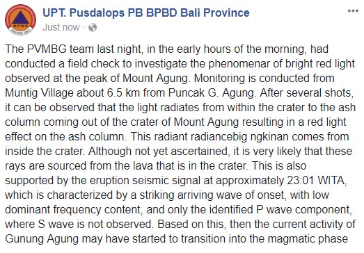
On the previous thread, Tomas A reported the light/glow appearing on the web cam at 20.55 their time, a couple of hours before the seismic signal they are talking about so i assume the initial glow was thermal, not a reflective red glow. The first tweet of the red glow was around the same time as the seismic signal, possibly a little earlier.
The light at the summit is just about visible through the clouds, at exactly the same location as yesterday. The insects are in different positions.
Wind direction predicted to be towards north- northeast the coming days. Lets hope it stays there for awhile! Will take most of the ash out over the ocean.
So if the 1963 bulk deposit was 0.7km3, why is the eruption considered to be a VEI-5 event?
Because earlier numbers put it just above 1km3. The numbers in the post are based on a more recent recalculation.
activity on Öræfajökull rising again…
Sunday
26.11.2017 12:23:37 64.007 -16.613 1.0 km 1.9 99.0 3.5 km ESE of Hvannadalshnjúkur
Øystein L. Andersen
@OysteinLAnderse
Seguir Seguir @OysteinLAnderse
Mais Øystein L. Andersen retweetou Sutopo Purwo Nugroho
The Incandescence (red glow) that can be observed at the summit of #Agung during eruption at night, is caused by lava escaping the conduit, authorities say. Since last night the eruption at Agung is confirmed as Magmatic, and not Phreatic.
They are narrating, roaring in the mountains, 10 km.
ship noise on the mountain
Ship Noise? The only thing I can think of is when a steam plant is doing a blowdown operation or setting safeties. → A large “kapow” and a mad roar of steam.
I posted this on the last article but I think it got lost among the comments when agung started erupting for real. It concerns something I read on Jons blog the other day about something he said regarding oraefajokull.
Apparently (based on this website: http://isor.is/frettir/hugleidingar-um-eldsumbrot-i-oraefajokli) oraefajokull has already started erupting and it is a lava dome extrusion under the glacier in its caldera. I dont know how likely that actually is but given how it means oraefajokull has already started erupting it seems significant.
On the site I of interest there is also a link to an interactive geological map of Iceland which some of you might already know about. (http://jardfraedikort.is) I think it would be very useful to have a direct link to it somewhere on this site.
In particular I am interested in what appears to be a long line of vents in the northern volcanic zone terminating with a big lava field in the northern tip of Iceland called ‘raudholarhaun’. GVP says it is part of the sveinar fissure of the fremrinamur volcano system. If you look on the map it is really obvious. And it looks like a big eruption happened there at some point.
(can someone put actual links to those adresses please)
-turtle
Apparently the IMO debunked that site and it’s suggestion of a lava dome extrusion.
I didn’t actually know that it was debunked but it really doesn’t surprise me though. I just thought it was interesting anyway.
I didn’t until I did some digging and asked Carl and a few other sources.
http://icelandreview.com/news/2017/11/25/no-sign-eruption-oraefajokull
No tremor on the drumplots = unlikely it’s begun yet.
At 21:48:25 a large glow Agung.
https://youtu.be/islcMmfHHqE
That camera has now frozen, but the large glow is confirmed by the competition
WOW! It look more energetic now…
For those interested
Updated map including todays quakes, IMO is working hard on a Sunday
https://vatna.carto.com/builder/f4868c81-0cb8-48cf-b600-e956b68e7b36/embed
To me, the widespread pattern of quakes around Öræfajökull would suggest an increase in pressure in the entire system not just one feeder. When I look at this it does not seem to be an intrusion more an generalizes swelling of the surrounding area?
Thanks Ian. Will be exciting to see if this will be a run up to eruption!If magma is moving upwards as the quakes may suggest. Maybe a swelling of the general area as you suggest. A result of a rifting episode or the plume pushing harder than usual?
Excellent, thank you very much. Sorry for not writing too much here, I use only the translator. I am registered as Pyter since eruption of eyjafjallajökull for a joke. “Taìs Cossa” , Facebook
Øystein L. Andersen
@OysteinLAnderse
Seguir Seguir @OysteinLAnderse
Mais
Eruption is continuing into the evening at #Agung volcano. Tremor recorded on the seismogram seem to have increased somewhat in strength, the last couple of hours.
Very small change though. Wonder if the current activity will fade out or if it will lead to a lower pressure and an explosive boil over?
What we are seeing, has 1963 written all over it. Good thing the no-go zones are already in place.
Wild guess…. Degassed basaltic andesite is welling up to the surface, and may very well spill over the rim.
Meanwhile at depth….. Some fresher magma, filled with gas and bad intentions, is coming up (aseismically, since the conduit is wide open and there is no rock to break)….
As the last dregs of previous month’s intrusion are pushed out, pressure drops precipitously in the upper reaches of our Gunung Agung’s plumbing system….. and the activity goes from gentle, to strombolian, to violent strombolian….and when the new stuff reaches the surface, things start happening.
Don’t worry however, there is plenty of time left in this scenario to get everyone out of harm’s way.
However, the landscape (and livelyhood of those living nearby) may be altered significantly.
This is Hindu’s principle of reincarnation at work there….. In a few years forwards, the land will be fertile like never before…..
Haroun Tazieff had a word for those lands of volcanc fertility and destruction…..
“Ces contrées, par leur fertilité due aux cendres volcaniques, sont un paradis pour l’agriculture. Paradis où périodiquement l’enfer se rue”..
(Those lands, from their very fertile nature owing to volcanic ash, are a paradise for agriculture. A paradise where Hell rushes in at times)…
Loads of abrasive harping about spelling…
This falls way beyond the be nice rule.
We are a lot of non natives writing in English here, and this kind of nitpicking is clearly something that takes the joy out of writing.
Quite simply, when you write yourself you get to have an opinion.
Otherwise, kindly keep them to yourself.
/Owner
Was also quite surprised by this stuff…. We almost all here are non native English speakers, and already we are trying our best to be understandable at the very least… We don’t pretend to achieve literary status, we are trying to be mutually intelligible (hopefully) at best, while attempting to be informative, or at the very least get fuel for thought to be burned in an interesting way 😉
Please dear Peter, I’m sure your spelling and grammar are not exempt of blemishes too 😉
Que?
Who has been concered about spelling (in a critical way)?
tHIS GROUP HAS NEVER WORRIED A S~~~ %%% about spelling.
cONTENCT is the aim…
OK, toooo much sauvignion blanc but hey, whateyeronabout>????
I am actually a native english speaker but I don’t always spell my words right (only when im writing in my head I can do it just fine).
I kindly remind people that we do have pretty much only one rule. Be Nice.
After having to edit things I would like to remind you of this rule.
If unsure, reread what you have written, and ponder if it follows that rule. And then hit post.
Kindly!
Collegium of Admins
I appreciate if errors are pointed out and am happy to fix them. Post are often written in limited time and insufficiently proof read, and typos and other errors will occur. Such as writing ‘scared’ where ‘sacred’ was meant.. (that was in this post, now fixed). It is however best to keep such comments positive. People from all kinds of background comment here, in many cases in what is for them a foreign language. It makes VC such a rich and rewarding experience – we do not require perfect english from anyone, and do not judge based on language! (An occcasional chuckle can be excused.) There are also cultural differences, and what is ‘direct’ in one language can give the impression of ‘aggressive’ in another. ‘Be nice’ is a good rule to have.
As for metre versus meter, I myself prefer the American spelling on this.
For the record, as long as communication is served and important details are well expressed with no ambiguity, I’m happy. And with a legal background, nobody should be more picky than I am.
Spelling should always be in the old tongue!
https://twitter.com/uranusaturn/status/934881402511872000
Volcanic porn, beautiful!
Something changed on sismogram now…
And the lights in the foreground keep vanishing and reappearing. I think morning is going to show us a messy picture. Ashfall?
Does anyone have any idea what’s happening on the ground there?
This change can signify that volcano conduit is more bloked? Because on cam the volcano is not visible now…
My guess is that the vanishing is due to clouds. The quake-and-tremor was nice! If only we could see what is happening at the summit.
Twilight has begun but it is dark enough that the summit light is just about visible, It seems to be to the right of the ash column, and disappears when the column moves a bit that way.
Right! A quake, Something broke and then followed a stream of more noise. Tremor signal from moving magma?
Looks just like it. Pop went the cork…
I very much enjoy the posts from Albert and others in VC. Personality, mother languages and cultural differences give rich flavors to the post that I think most of us enjoyes. In the end it is about sience. For that you need a good enough english to avoid misunderstanding. If some contributors has a talent to present the science wowen into nice colorful stories, let us enjoy that without picking on unimportant details. I am sure that there are many other places were language snobbism better can be cultured!
I’m a native English speaker and as long as I can understand what is being said or implied, it meets my standard. Being what is generally considered to be a “redneck,” I have seen (and had) my fair share of verbal face-plants.
BTW, I project Agung total eruption at about 2,962,918 m³ DRE. Solidly in VEI-2 territory.
What a precision……!
I knew it was YOU who shook the innards of the beast in the first place ;p
seconded!
Don’t be fooled by the apparent precision. It’s just a numerical model output. The source documentation caveats the result as only being accurate by a factor of 4.
And by the way, that document is “A multidisciplinary effort to assign realistic source parameters to models of volcanic ash-cloud transport and dispersion during eruptions” Mastin et al, Journal of Volcanology and Geothermal Research
Volume 186, Issues 1–2, 30 September 2009, Pages 10-21.
It’s a quite informative read if you can get your hands on it. Mastin et al based their work on previous work by Sparks. The Sparks equation will yield similar results. (Both are contained in the paper if you dig around a bit)
The VAAC data comes from Darwin VAAC.
Hear hear!
A n impressive timelapse taken yesterday (Indonesian time) is on https://www.facebook.com/eyesofanomad/videos/799475396905988/
Now, strongest harmonic tremor since eruption started.
For me the only way to explain is that volcano conduit is blocked that makes tremor is rising a lot. No eruption visible on cam… this is very a dangerous situation!
In this case, danger is a relative term. Locally dangerous? Definitely yes. Globally dangerous? Not so much. So far it hasn’t gotten anywhere near the typical tropopause elevation. Until it can loft ash and gas beyond that, the only international hazard is to anyone flying into the ash cloud…. and Darwin VAAC is on top of that problem, issuing alerts for where there are hazards.
Maro Ray

@MarekRaj
8 minHá 8 minutos
Mais
#Agung eruption is developning. Strong harmonic tremor started !
Have a thought for those poor souls in Bali. Hope it won’t be too bad.
In cam we can see now some material ejection…
Owwww… Yet again…. Big fat quake. More of the blockage letting go??
Big quake!
Hope it’s not going krrrr…..krrr…. krrr… KABLAM!!! (in a more scientific manner, all the blockages are giving way one after another, until the path is clear to the surface…)
And while everyone is watching Bali, a world away Öræfajökull is quietly building up a good-sized swarm at the summit, with a largest quake of M1.9 so far.
Is it the final run for the (otherwise volcanically quiet) 2017 Pliny Awards? (at Erik Klemmetti’s blog)
Pliny the Younger or Pliny the Elder? In the latter case, it might be more akin to a Darwin award..
Pliny the Younger, of course….. He was the one who wrote the letter!! (and he was OK looking at it from *far* far away…..)
And Grimsvötn is holding its breath….
Tomorrow the timespan of 2375 days after last eruption is reached. Quite a difference with the last two seismic build ups!
http://hraun.vedur.is/ja/vatnajokulsvoktun/grf_uppsafn.html
20 quakes in the last 48 hours.
Oraefajokull can have a similar or bigger eruption than Bali’s Agung, based in past history. VEI4 to 6
But both volcanoes only have a few historical eruptions.
Oops….
IDD41300
VA ADVISORY
DTG: 20171126/2150Z
VAAC: DARWIN
VOLCANO: AGUNG 264020
PSN: S0821 E11530
AREA: INDONESIA
SUMMIT ELEV: 3142M
ADVISORY NR: 2017/22
INFO SOURCE: HIMAWARI-8, CVGHM, WEBCAM
AVIATION COLOUR CODE: RED
ERUPTION DETAILS: VA ERUPTION TO FL300.
That puts the mass ejection rate up to around 95.58 m³/s
Fl300 =? 30000 feet? That’s in the ballpark of the 1963 events……
Lava on the move?!
Ballpark, yes, but not there yet. I calc the current volume of DRE at 0.00358 km³. From the article, 1963 was at 0.4 km³.
Big explosion with nice mushroom cloud right now…. Already dissipating, but what is coming out looks black and mean….
Well, the tremor on the drumplot is starting to get fat… not good.
WOW tremor just give a jump!
Ramping up ?
https://magma.vsi.esdm.go.id/live/seismogram/
Going hard and fast now…
https://www.youtube.com/watch?v=islcMmfHHqE
It’s no more passive emission of ash….. There are explosions, some of them quite sizable, and heavy mushroom clouds of ash.
Look on the right size of the plume how it roils out. Impressive.
seismo is saturated now. It’s a biggie……
They should turn the cameras up …
The other cam is running again… WOW !
Seems to be two colours of ash now: the dark stuff and some lighter more pinkish toned stuff. Two vents?
Is it me, or are there at least 2 vents, one of them giving off quite dilute high plume of ash, and another delivering what looks like Vulcanian explosions?
Very good view of the eruption here: https://www.youtube.com/watch?v=islcMmfHHqE
Hope everyone is safe…
PVMBG Increase level OF mount agung to level 4 (HIGHEST!!!)
https://twitter.com/radiobalifm/status/934916912697327616
I see two columns off ash, bright and dark. Are they from two sources ?
Yes i agree, it seams two diferent sources…
Appears to be at least two plumes, possibly three. The nearer one (North?) on camera linked to above looks whiter so perhaps more steam? Behind (South?) is much bigger and is dark and composed of ash. Difficult to tell is there is a third plume to the east, behind the steam plume, as it is hidden behind falling ash but, if so, it must also be a dark ash plume.
Seismo appears to show steady harmonic tremor, which matches the pictures.
And for those of you keeping score… The tropopause in the area of Agung is usually around 16+ km high. Right now the eruption column is at about 9 km. That means that everything it is putting out is in the troposphere here with us and is likely to stay that way unless Agung does something funky.
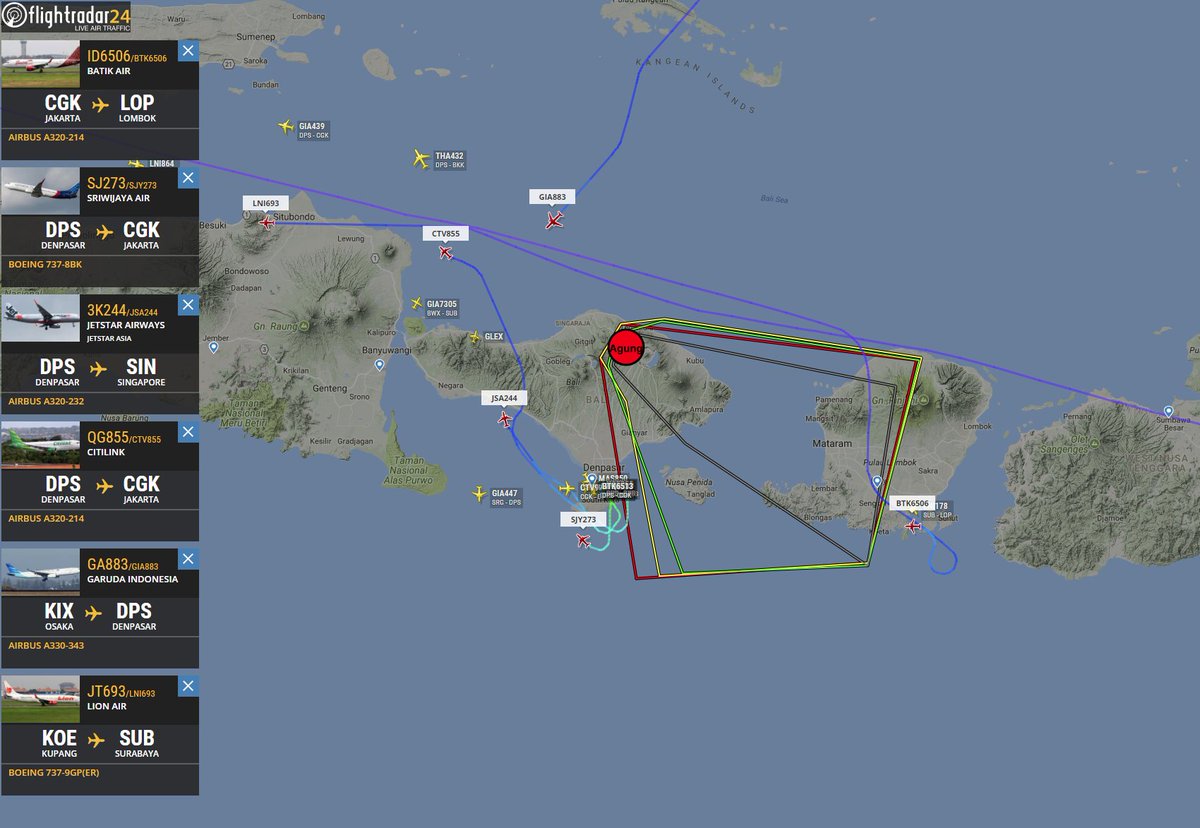
There’s quite a procession of inbound long-haul flights being diverted from Denpasar.
Also a couple of outbound planes sitting at Denpasar with transponders on, but they’re not looking like going anywhere soon. Also I see a flight from Jakarta on the way – half way there, but now looking like they’ve had a change of plan, it seems to be descending – probably toward landing at Surabaya rather than turning back.
Adam HarveyConta verificada
@adharves
Seguir Seguir @adharves
Mais
#Breaking Mt Agung eruption is changing and there’s a potential for a bigger eruption, warns Indonesia’s disaster management agency. Evacuation zone has been extended. Alert status now Level 4
Definitely three plumes now. Two whiter (steam?) ones and a larger, dark ash one.