The volcano Cumbre Vieja in the island of La Palma has been showing signs of unrest. The question on everyone’s mind is, will there be an eruption? Maybe, or maybe not. This is always hard to know.
The Spanish National Geographic Institute reports inflation, a total of 10 cm of deformation. As such it is evident that there is magma on the move under Cumbre Vieja, it has intruded underneath the volcano.
https://www.ign.es/web/ign/portal/noticias
There have been multiple swarms of earthquakes since 2017 in Cumbre Vieja, a total of nine. Previous swarms were probably magma intrusions too, but which did not reach the surface. The recent swarm however is more shallow and more intense than its predecessors which raises the possibility that the outcome may be different.
The current swarm started on September 12. A total of 4530 earthquakes have been detected at depths of mainly around 10 km, although there are a few which have been very shallow. The swarm commenced under the summit of Cumbre Vieja, where a magma conduit probably exists which is supplying the intrusion. Earthquakes have propagated to the northwest. This probably represents the propagation of magma filled fractures, possibly sills, radially from the centre of Cumbre Vieja. However the earthquakes only show a but a blur of what is going on down there. The exact shape and pathways used by the intrusions cannot really be known with much precision. It is somewhat similar to the prelude to the eruption of El Hierro in 2011 which also seems to have commenced with a sill that later propagated a crack towards the seafloor.

Image from the NASA.
The location of the earthquakes suggest a possible eruption in the NW sector of Cumbre Vieja. However there is a factor of unpredictability. The exact path that the intrusion takes may or may not connect with the surface, such being difficult to know if there will or will not be an eruption . The precise location where the intrusion will breach the surface is also difficult to know. The fissure could open in the middle of a town, in a forest, or it could open underwater, which are wildly different situations with wildly different consequences.
We can know however the style that the next eruption of Cumbre Vieja will take, whenever and wherever it happens. To do this we must look at the past history of this volcano.
La Palma
La Palma is one of the Canary Islands. It was formed due to volcanic activity. The oldest rocks of the island are 3-4 million years old and belong to a submarine volcano. These submarine lavas are now found at heights of up to 1500 meters above sea level in the Barranco de las Angustias, in the old northern part of the island, which shows the enormous uplift that the island has undergone. Probably numerous sill intrusions have pushed the volcano upwards.

La Palma. From the NASA.
La Palma is shaped like an arrowhead. The northern part is formed by the old Taburiente volcano. Deep gullies dissect the ancient lava flows exposing the overlapping layers of volcanic extrusions and the frozen dykes and sills which cut through them. The volcanic edifice was destroyed by a series of giant landslides, the last of which took place around 560,000 years ago. Activity continued inside the landslide scarp until 530,000 years ago. Afterwards activity died out in the northern half of the island.

Large scarp formed due to erosion of Taburiente volcano. Some sills and dykes are visible on the left. From Wikimedia, by Zyance.
Volcanic activity in the southern half of the island has been ongoing for at least 125,000 years and has constructed another volcano known as Cumbre Vieja, or also simply as Dorsal Sur, “Southern Ridge”. It is a shaped like a ridge in a N-S direction. Despite being different edifices it seems that Cumbre Vieja is part of Taburiente’s structure. Taburiente had 5 subtle radial rifts. This is much better appreciated in submarine shield volcanoes which are often shaped like ridges or like three to six-pointed stars. Knowing well the shape of submarine volcanoes I can see that Taburiente displays the same five-pointed star structure, although being subaerial it is not so easily visible. The longest, dominant rift goes southward, known as Cumbre Nueva. It can be seen that Cumbre Vieja is the southern continuation of Cumbre Nueva.

Topography of La Palma. Note the northern volcano Taburiente which is cut by deep gullies and a central erosional crater, and the southern volcano Cumbre Vieja which is dotted by young volcanic cones. There is a bow-shaped ridge connecting both volcanoes, this is Cumbre Nueva, the ancient rift zone of Taburiente, partly destroyed by a landslide. From maps-for-free.com.
The main magma erupted in La Palma, as well as in the Canary Islands, is basanite, which is relatively fluid, but not as much as say Hawaii. The fluidity is comparable to the more frequently active Mount Etna in Sicily. The magma is not so fluid that all of it would flow away upon landing on the surface, but it is not so viscous that it is entirely blasted into light pumice and ash carried away by the wind. The eruption style is known as “violent strombolian” or “violent hawaiian” depending on whether it produces explosions or sustained fountains. It is the middle ground between the blazing rivers of lava and the billowing columns of ash. This style is ideal for producing pyroclastic material that rains around the fountain, rapidly constructing a mountain around the vent, known as a scoria cone. These conical mounds of ejecta are everywhere over Cumbre Vieja. Because the volcano doesn’t have any central vent that erupts repeatedly, then it makes a new fissure each time it erupts. The pyroclastic material rapidly oxidices. This gives the terrain various hues ranging from black to red, which together with the abundant canarian pine trees gives the characteristic landscape of Cumbre Vieja.

Desertic volcanic landscape near the southern point of the island. San Antonio volcano visible in the centre formed in the 1677 eruption, The brighter cone to the left of San Antonio is Teneguia, which formed in 1971. From Wikimedia by Tony Hisgett.
Other magma types present in Cumbre Vieja are the tephrite and phonolite groups which are more silicic and viscous. They are present in trace amounts making small lava domes. A small volume of phonolite was emitted in 1585 producing tiny cryptodomes and domes, although the eruption was mainly basanitic.

Types of volcanic rocks depending on silica and alkali content. From Wikimedia by Woudloper.
Cumbre Vieja last erupted in 1971, 1949, 1712, 1677, 1646, and 1585. It is the most active volcano in the Canary Islands. Eruptions have taken place at intervals of 20-60 years. The exception being the remarkable 237 years long dormancy between 1712 and 1949. Why did this happen? It is possible that the volcano follows cycles of more frequent eruptions separated by long dormancies. Another possibility is that the enormous 6-year long eruption of nearby Lanzarote Island, occurring in 1730, induced a long dormancy in Cumbre Vieja.
It would not be unexpected that now, 50 years after the last eruption, there was a new one.
The eruption of 1949
The eruption that took place in 1949 is an interesting example of a typical Cumbre Vieja eruption.
Swarms of earthquakes had been frequent since 1936 and leading until the eruption. The morning of June 24 some fumes were noticed, and soon afterwards a towering black column of ash was rising hundreds of meters, if not more, into the sky. A new volcano had formed along the crest of Cumbre Vieja. The fissure had opened a small distance north of the highest point of the ridge. The vent is known as Duraznero.
During the following days Duraznero continued to erupt, belching out ash and rocks. Earthquakes frequently rocked the nearby communities and steaming fractures opened in the ground around Duraznero. Magma must have been making its way into growing fractures. Over the days the erupting fissure progressively grew to a length of 500 meters and developed 5 main vents, of which Duraznero 2, at the southern end, was the most active, creating a 170 meter-wide crater. The activity was entirely explosive but of a low intensity that must have been little more than a slight annoyance to the local population. The erupted lava was tephrite. Earthquakes were more impactful, they damaged houses, cracked roads, and occasioned rockfalls. On July 6 the ash was carried downwind over the island of Tenerife where it wrapped around the summit of El Teide in a menacing black cloud.

Fissures of Duraznero. Image by KrisNM.
On July 8 a stream of lava came out from a new location known as Llano del Banco, 3 kilometres north of Duraznero, and from the other end of a system of cracks that had opened up. It did so quietly with no explosive activity whatsoever. The lava must have been degassed by Duraznero, gone into cracks, and found an outlet at a lower elevation from Llano del Banco. The lava erupted was tephrite, same as that of the earlier phase of the eruption. The initial fissure died out at about the time the new vent opened.
It is common for eruptions of Cumbre Vieja to have some vents which are dominantly explosive while others are effusive. In the eruptions of 1646, 1677 and 1712 it also happened that the vents which opened at the highest elevations had explosive activity and built large cones of scoria, while other fissures opened at lower elevations, sometimes offrift, and even at sea level, producing solely lava flows. The eruption of 1949 shows how the process works. A vent that is high up degasses the magma and then it is carried laterally through fractures towards openings downslope from which it emerges effusively.
Lava descended in fiery tongues from Llano del Banco down the flanks of the mountain. People were being evacuated as the flow headed for populated areas. It took 10 hours for the lava to reach the main road of the south of La Palma. Later that day the flow had destroyed 20 structures, including houses, cellars, and barns.
On July 10 lava cascaded over a cliff into the ocean. From this day on the entry of lava into the sea became continuous, and a lava delta was gradually constructed. Cloud of steams rising over the waters were illuminated by the convoluted streams of incandescent rock.
A new change in the eruption took place on July 12. The composition of lava erupted from Llano del Banco changed from tephrite to basanite. It became less silicic. At a similar time a new vent opened 400 meters north of the initial vent of Duraznero in the location known as Hoyo Negro. Black cauliflowers of ash pierced with flashes of lightning rose rhythmically from the Hoyo Negro vent. It erupted various magma types including basanites, tephri-phonolites and phono-tephrites. Once again the vent uprift was explosive while the vent downrift was effusive. The basanitic magmas must have released their gas into the explosions of Hoyo Negro and then come out laterally through the opening in Llano del Banco.
Hoyo Negro projected bombs to a distance of 1 kilometre from the vent snapping the trees and setting portions of the pine forest on fire. Clouds of ash frequently dusted the western part of the island. The explosions excavated a 400-meter wide crater on sloping ground. This created a spectacular 200-metre cliff against the higher side of the slope, which exposed the many layers of ejecta painted in a variety of colours.

Hoyo Negro. Image by Rafael Medina.
A raging stream of lava continued to issue from Llano del Banco and cascade towards the coast. Despite erupting continuously for 18 days the vent produced no distinguishable ejecta, and shows how the gas had been entirely removed from the melt before erupting. The ground above the fissure collapsed among loud noises, the rocks fell into the stream and were carried away, a length of 150 meters of rock above the conduit was eroded away and disappeared leaving behind a deep chasm in the forest.
On July 22 the activity of Hoyo Negro was down to a solfatara. Llano del Banco was also dying down. By July 26 the eruption had fully stopped.
Early on the morning of July 30 the eruption suddenly resumed. Duraznero and Hoyo Negro exploded simultaneously. An hour later fluid basanite lavas emerged from the location of Duraznero 1 and poured into an old crater where it formed a lava lake which then overflowed and formed a narrow stream of lava that rapidly sped down the steep slopes of Cumbre Vieja, cutting the road of Santa Cruz de la Palma, and nearly reaching the sea after 11 hours of advance, when the eruption came to a stop. This was the last episode of the 1949 eruption.
The flow of July 30, although of rapid advance, it was fed at a rate of only 10 m3/s, which is very low. It was also similar to the mean eruption rate of Llano del Banco, which was approximately 14 m3/s. The explosive activity was of little volume so it probably does not change the overall numbers too much. As such the eruption of 1949 was of very low intensity, in both its effusive and explosive counterparts. Slow eruptions are typical of the Canary Islands. Such low intensity eruptions do not pose much of a hazard to the people, in fact no one died in the 1949 eruption, despite 120 houses or so being destroyed, and people having approached the eruption in order to view it. This doesn’t mean that the hazard is inexistent.
If someone stands very close to the vents he/she could be asphyxiated by the noxious gasses or may be impacted by a lava bomb or by lightning. Rarely when lava flows reach steep slopes they collapse into blistering landslides resembling small-scale pyroclastic flows that could potentially kill someone. Conditions around volcanic eruptions can change suddenly in unpredictable ways and become hostile to humans. Safety is not guaranteed.
If Cumbre Vieja erupts in the future it will probably resemble the 1949 eruption in many ways: an earthquake prelude to the eruption that may deal damage to structures, unpredictable opening of fissures, some vents producing mainly explosive activity while others feeding mainly streams of lava that destroy human properties, and also the likely entry of lava into the sea.
Of course if the current earthquake swarm will culminate in an eruption or not cannot be known for sure. Swarms before the 1949 eruption occurred as early as 1936 and did not culminate in eruption until 13 years later.

San Martin volcano, formed in a 1646 eruption. Image by Rafael Medina.
Interesting links
Eruption of 1949 (in spanish).
GRAFCAN visor (includes geologic and topographic maps).


.jpg)
https://twitter.com/ACFIPRESS/status/1440054791053275144
Was this water reservoir the steam plume from yesterday?
I think its the Canal de Dos Pinos in the tweet.
epic drone compilation.
https://twitter.com/seismo_steve/status/1440219308097867789?s=20
Is the eruption still going?
Is the volcano still inflating?
Jesper,
you have the same capacity to check the IGN website!
It has no signs of slowing down just yet.
Copernicus impacted map (sorry if it was posted already)
https://twitter.com/CopernicusEMS/status/1440194478321455107?s=20
impacted areas – typo
166 buildings destroyed
Lava flow covers 103 ha
Poor people.
Full resolution image at https://emergency.copernicus.eu/mapping/system/files/components/EMSR546_AOI01_GRA_PRODUCT_r1_RTP02_v1.pdf
https://emergency.copernicus.eu/mapping/list-of-components/EMSR546
is worth bookmarking for future mapping data.
Sinse the bigest quake yesterday the quakes are rising again… all of them between 1 and 2Km
.0 mbLg
SW EL PASO.ILP
2021/09/21 08:08:49
1
+info
2.6 mbLg
S EL PASO.ILP
2021/09/21 06:19:09
1
+info
3.2 mbLg SW EL PASO.ILP
2021/09/21 05:06:50III-IV
1
+info
2.2 mbLg
S EL PASO.ILP
2021/09/20 23:35:05
2
+info
2.9 mbLg
SE EL PASO.ILP
2021/09/20 22:53:30
1
+info
3.8 mbLg SE TAZACORTE.ILP
2021/09/20 20:32:46III-IV
http://www.ign.es/web/ign/portal/ultimos-terremotos/-/ultimos-terremotos/getDetails?evid=es2021smjdw&zona=1 does not give the depth of this moderate quake. Is this still being worked out?
https://twitter.com/ita_dc/status/1440230262709768198
Also, see:
A big inflation despite the ongoing eruption !
That seems strange . Worrysome.
Yes that’s not good… yesterday was 15cm i think.
I have used up a 1/2 hour now trying to chase down the GPS station network on La Palma. Yes INVOLCAN knows about the 5 stations LP01..LP05 and even shows them on a bulletin http://www.involcan.org/wp-content/uploads/GUAYOTA/guayota-lpa-en-co.pdf map, but does not label them. The head scientist in Japan has a map, but this does NOT correspond, see http://www.involcan.org/vigilancia/red-geodesica/ and look for the google map display of the GPS stations. I did find that the search engines were NOT helpful when I typed in “La Palma GPS network” The list of GPS stations archived by UNAVCO was no help either (honestly I have not seen such a mess with GPS stations in quite awhile)
Finally I sent a letter to INVOLCAN pleading for their help in labeling their 5 GPS stations. Hopefully someone will realize what is missing and add it to their web pages.
And yes, I might have overlooked something, but I did turn over a few webpages trying to chase all this down.
I posted a long message about trying to locate LP01..LP05, does anyone know where these GPS stations are?
Found it. Hope it helps.
https://www.ign.es/web/ign/portal/vlc-gps
You have to go to the la palma tab of course!
Luis, I did locate a 552 page book in Spanish from Madrid which has everything anyone wants to know about the volcanics of the Canary Islands. On page 175 of their online pdf copy https://core.ac.uk/download/pdf/148679437.pdf I found a map of their proposed GPS network on La Palma, with about 25 stations or so, but the labels do NOT correspond with the Instituto Graphical Nacional labels.
What about this Etna.
Is a little spoiled.
Fagra begins and Etna begins the same.
Now the Cumbra has begun and Etna immediately behind.
https://twitter.com/LavaCentre/status/1440232832148803587
https://twitter.com/darioscp/status/1440225846644461571
Pingback: LAVA DA ERUPÇÃO DO VULCÃO EM LA PALMA AVANÇA PARA O MAR
Sorry for a short diversion to the norther part of the Atlantic. Ist the “Magma Soliton” mentioned here to be taken seriously? Or is it a case of a nonlinear dynamics guy seeing solitons everywhere he goes? (Disclaimer: The guy himself is a very solid and prominent mathematician, I am not claiming the person is not to be taken seriously)
Unfortunately I was not able to find the paper he mentions. At the very least I’d be very intrigued how they think they know the underlying parameters so exactly that they can infer volume from speed within a factor of two or so. And of fundamentally where the dynamical part is coming from in the underlying theory.
Forgot to mention, it is towards the end of the video, starting 7:40
Hi, I enjoyed it! His opinion and the views! Time will tell!
I enjoyed it too, but the what is behind the opinion?
Time will tell? Well, even if the eruption happens to stop in that timeframe they mention, that would be nowhere near a proof that the theory was actually correct. But I do not really care. I am just trying to understand how realistic it is, and then, how the dynamics is supposed to work.
Well all I know is my gut feeling he could be right-in light of the off on off on mode-it just seems its loosing steam.But what would I know.
My national news broadcast- reports the shutting down of the La Parma eruption-but ongoing lava will still be on the move.Notice the live webcam now does not focus on the vent/vents but the recent fresh lava field.And to top rhis off-could no longer gear dogs barking ..
hear dogs ….oops
Looks like it is still going to me, maybe the lava flow stopped which is what they refer to? It seems likely that more vents will open, effusive vents around the crater but maybe still some distance away, and they will probably be silent and without warning. The GPS signals are concerning, shows this is far from over.
Ok, thanks for that, felt a bit foolish in asking before- but it was on my mind.
I agree. It sounds like a series of short-lived vents is a common eruption mode at La Palma. It is likely (but never certain) that there is more to come.
Thermal imagen right now onboard the Cuco from the Guardia Civil. Lava fountain and flows are clearly visible
https://twitter.com/involcan/status/1440309932385996809?s=20
While trying to dig up the GPS labels and their exact geophysical locations on La Palma, I did see this https://parquesnacionales.cnig.es/escenas/PNCaldTaburiente/Scene/App/?scene=Production_3_3MX_mallaunica_WEB&cX=-3648.8918&cY=-8064.7116&cZ=1059.2361&upX=0.0000&upY=0.0000&upZ=1.0000&tX=-1668.7865&tY=-8462.3991&tZ=776.3053#%2F which seems new
Is this what you are looking for?
Go to la palma tab.
https://www.ign.es/web/ign/portal/vlc-gps
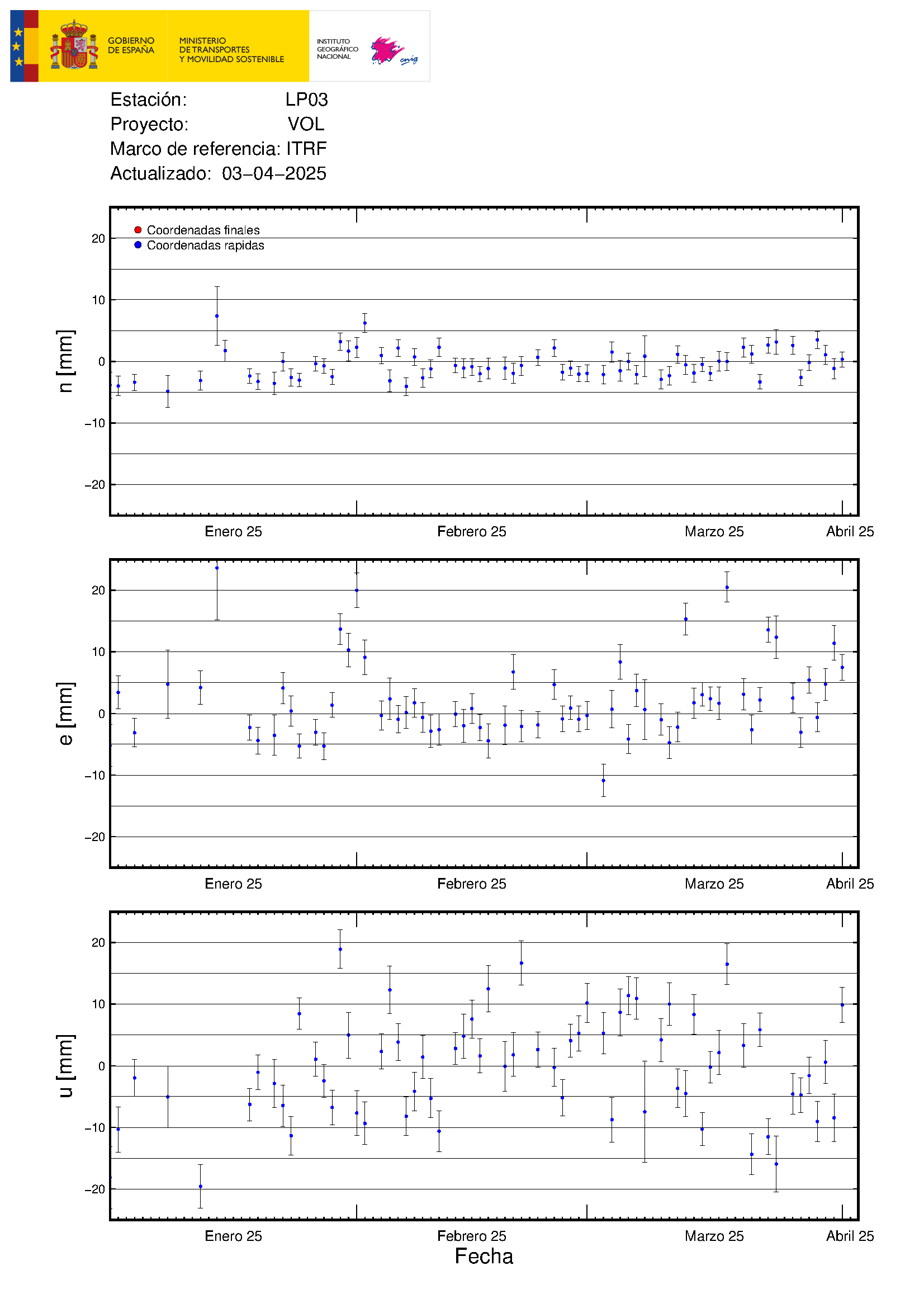
I don’t know if it’s significant or not, but your link shows that LP06, on the other side of the island, has gone up approx. 4 cm also.
we are not thinking lanzarote, are we?
Lanzarote is East of Tenerife and Gran Canaria. Besides La Palma El Hierro is active (South of La Palma). The whole Western area is acitve. El Hierro and La Palma might be one island in the future.
Besides Hector mentions in his piece that there was a period of dormancy in the West, and in this period Timanfaya erupted.
That’s a great observation. If it is valid, Lanzarote will be quiet now.
No, I just went to his link and saw that LP03 and LPo4, near the eruption,were showing uplift, as expected. But LP06, on the other side of the island, also showed some uplift (4 cm). Just wondering if this is normal or if the uplift area is larger than expected.
lanzarote 1730 to 1736 was propably an oddity afe there even any exam0le of other similar sized eruptions 1km3 in last 20000 years in the canaries?
never searched for it myself honestly
LP06 may be a response to the magma chamber settling as the lava exits? A kind of ‘isostatic’ recovery.
It may have sunk over the last few weeks as the magma intruded.
Yes, this is the information I was looking for.
And in other news, the Kilauea caldera has entered a new phase of rapid inflation/expansion
Wow. They must have a soul. They found out that they have admiring spectators and decided to go on with the show. 😉 All of them.
Was waiting for someone else to point this out 🙂
It recovered from the earthquake swarm very fast, barely a week, and has accelerated the upward trend of all the GPS stations around the summit.
The only station showing deflation is at Pu’u O’o. I think I know why now, the pressure going to the SWRZ meant there was nothing being added to the magma body under Pu’u O’o, and the south flank movement has been letting it settle. The scale is very small here, much less than the summit stations, so could be sensitive to such movement. It is ongoing so evidently the conduit didn’t reconnect.
https://twitter.com/en_teror/status/1440027947851673601
La Palma is a catastrophic zone”
The President of the Canary Islands, Ángel Víctor Tores, announces that he has requested European solidarity funds after the meeting with the Cohesion and Reform Commission.
https://www.canarias7.es/politica/directo-ryueda-prensa-20210921115433-nt.html#vca=web-push&vso=canarias7&vmc=Declaran_a_La_Palma_'zona_catastr%C3%B3fica'&vli=_
Lots of black smoke now on the live feed.
https://youtu.be/1odOF3j5F8Y
And in the last two hours they got more shallow quakes and some deeper too…
On the live feed there are pulsations just like a hearbeat its fascinating to listen to a once in a lifetime experience.
Lava flow is still moving, but its very viscous
https://twitter.com/involcan/status/1440309932385996809
https://twitter.com/rtvenoticias/status/1440269642962915330
Involcan estimates that under the Cumbre Vieja there are at least 17 million cubic meters of magma that could rise to the surface.
12 quakes just today… some deep.
https://twitter.com/RTVCes/status/1440322562316070917
That’s actually not a whole lot from a VEI perspective…
Math is not my strong suit, what would that figure be in VEI terms?
Also it’s fairly visually confusing because I keep reading about how small this eruption is, yet on webcams and in pictures it looks like absolutely enormous fountaining and as if there’s a massive amount of lava being erupted.
Not alot .. around 10 times less than the current Fagradalshraun volume
We are seeing a small eruption of ultrabasic/ ultramafic Basanite / Tephrite lava in Canaries
I think it may reach the ocean .. the Aa will be steamy as Hell as it tumbles into the sea
No hotter lavas yet .. have arrived
Only old stuff still
thats seems to me like a very conservative figure, i think usual eruptions are in 100s millionof m3
La lava ya ha entrado en el pueblo de #Todoque, una localidad, ya desalojada, de unos 1.200 habitantes. La llegada del magma hasta el mar podría tardar mucho más de lo previsto
https://twitter.com/RTVCes/status/1440329718042038279?s=20
(@Clive) I found the dubious ‘chimney house’ at last. It was not the first one to be hit by the lava stream, but indeed among the first houses. It is the house just north of Montana Rajada and was hit by the southern section of the lava stream passing the mountain. There is not much doubt that this is the house shown in the famed video – so it wasn’t fake news.
There we are. This was a very pretty vacation house. Hope that owners find a way to reinstate the idyll somewhere else.
A map showing the coast would help.
The last issued lava map didn’t show the coast when it is only about 2k away now.
https://twitter.com/samgerrits/status/1440230867239010314/photo/1 might help
From Copernicus, https://erccportal.jrc.ec.europa.eu/ercmaps/ECDM_20210921_La_Palma.pdf
Thanx Randall
Aha, well done!
And such a shame, too, that it was crushed. I feel sorry for the family and hope they can get help to rebuild. They must have loved that home. At least it was not their primary one.
Thanks for posting the information. I can sleep tonight. 🙂
Look at this:
https://elpais.com/videos/2021-09-20/video-la-lava-del-volcan-devora-las-viviendas-de-la-palma.html#?rel=mas
Lava devours houses
I am talking La Palma now not Iceland.
Looks like Fagradalsfjell is taking another stab at it, to get back in the game. This time the tremor looks like it will succeed.
It’s an equinox, so the sun should set at around 6 local time everywhere today, right? So why is it apparently the middle of the night at Langihryggur at only 4:30ish PM?
That’s not really how the equinox works…
“That’s not really how the equinox works…”
Isn’t it? Surely at the equinox you do indeed get 12 hours day and 12 hours night everywhere on earth. The exact date/time varies, it’s actually tomorrow at 19.21 UT
https://en.wikipedia.org/wiki/September_equinox
So today everywhere in the world will be around 12 hrs day (increasing a little as you go North from the equator). It does depend on exactly how you measure “day” though, as it’s light during and after sunset and during and before sunrise.
You can check figures here for today, though I’m not sure what their definitions are
https://www.timeanddate.com/sun/
Thule, Greenland 12hrs 41m
London 12hrs 15m
Sao Tome 12hrs 6m – this is on the equator
Cape Town 12hrs 5m
Punta Arenas 12hrs 6m
Belgrano Base Antarctic 12hrs 14m
It is about 12 hours everywhere around the equinox, but the 12 hours may not be centred around noon local time. That can vary a lot far north where the solar time changes quite a lot across one time zone
There is also a little extra daylight because of the width of the sun, and because of refraction in the atmosphere. That can add a few minutes
Iceland true noon is approximately at 13:35 local time.
Iceland is an Eldritch place….weird things happen…. 😀
Seriously, like wtf (facepalm)
if You are talking about places farther north on the globe the hours of daylight change dramatically. Go to a site of Sunrise and Sunset for places far North or South and You can see the variations.
Sunrise and sunset today in Reykjavik are 7:08am and 19:31pm local time. 12 hours daylight but an hour shifted towards evening. They are on GMT all year – daylight saving (a name that promises too much) is not helpful this far north
That’s still not consistent with pitch darkness at 4:30pm…
The camera does not always work, and I think is sometimes turned off when there is little (or less) to watch to preserve power. The still cameras can be better
Yes, looks like it. Only 3 days this time. How long before the wall will fall?
> “This time the tremor looks like it will succeed.”
Not sure about that, there is a really nasty storm over SW Iceland. This level/spectrum of “tremor” is more likely to be from that.
A solar eclipse I guess. Or a black bear. These are just the two most probable explanations.
This was an answer to Twisted One’s question.
Another explanation: The video looks very much like the famous Malevich painting, so maybe russian hackers switched the image with a cam in the Tretyakov gallery?
tsk, tsk,
Slow internet. At the typical speed one gets nowadays from internet providers, 50 microbit/sec, it has taken the image 12 hours to get across.
Just a general comment……………… we can’t really tell a lot about someone if the only information we have is that they can type a comment. We can’t tell if they are 6 or 86 or if they are impared or fully functional (i really don’t know anyone who is fully functional) This site does better being kind. So let’s not wander from the path. If You can’t say anything nice…………………………..
Best!mots
(got it)
La Palma: Lava is heading towards the church Parroquia San Pio X of Todoque, which is on small hill. The nice building might survive this and could then serve as a famous landmark overlaping the lava field. Let’s keep our fingers crossed.
A few hours ago. I can’t find more recent information on how the stream went. It seems on Giggol-Arth that the church (also the childrens playground) is on hill, the lava stream could very well run south and spare it.
That would be nice. It would be even nicer if the lava could just follow the road and spare all the houses. Or stop advancing – that might actually be possible if the vent extinguishes
Albert
This basalt is very cold and Viscous.. do you think it will reach the ocean? It looks alot like the Heimeay Basalt
How much in million cubic meters have erupted already?
I’m surprised it’s gone this far, honestly. Ignoring for the moment the datapoints of temperature and viscosity, I suspect that most if not all of the magma coming from the big cone is being blown into the air and most of the flows are essentially rootless–degassed and cooled before they even begin to flow.
Yes, stage one viscous flows. The majority of flows in other eruptions are stage 2, when the fluid lava erupts. Still waiting on that one. I expect most other eruptions are phreatomagmatic early on so no chance for flows in stage 1,
take a look at the 1:56 mark in this video https://www.youtube.com/watch?v=KNUJYLnPq94 is this the church?
http://albumdelasmanchas.blogspot.com/
Old photographs San Juan from Cueva de las Palomas
test
Watching on https://www.youtube.com/watch?v=hfoWeQnFSx4 right now (18:10 UTC) the fountain is getting bursty and on one burst, lots of white smoke was blown out the 2nd vent.
I enclose 6 snapshots of the smoke blown through the 2nd vent area when the explosive bursts from the main fountain hit. See https://drive.google.com/drive/folders/19YyEOiNtmyIJ8XJO0Pd5sjzjmz3melWK?usp=sharing
Today is three months to the day after Carl predicted the eruption in Iceland would be over.
Sorry to be a pain.
His thoughts on the history since his prediction would be interesting.
ten days ago I was beginning to think it was over too! The deflation in the wider area is continuing, I think: more magma was erupting than being added. I don’t know Carl’s current thinking but he was expecting the eruption to decline. Has it happened? The eruption rate declined from 13 to 8 m3/s, but I haven’t seen a recent measurement. Has it stopped? Apparently not. We need to try again on volcano prediction! I was very impressed with Hector, by the way, putting up a La Palma post a day before the eruption began.
I agree
The most recent measurement ist from a week ago, at 11.8 m^3/s. (Average from approximately 20 days prior to that date). No error bar given.
So the output is still pretty much constant at this point, surprisingly.
Just found a bit older time-lapse:
https://www.ruv.is/frett/2021/03/20/fylgstu-med-hraunrennslinu-i-dag
“…0,2 til 0,3 milljón rúmmetrar af kviku…”
Have there been some changes after this… 😉
Of 1949, Hector wrote: “On July 10 lava cascaded over a cliff into the ocean. From this day on the entry of lava into the sea became continuous, and a lava delta was gradually constructed.” It’s my impression, from the lava map posted earlier, that there is area which has been newly subdivided, is under recent development, and is likely to be overwhelmed. It that the same delta or is it elsewhere? It’s also clear that the prior flows have been built upon, apparently with no concern for future “damage to structures, unpredictable opening of fissures, some vents producing mainly explosive activity while others feeding mainly streams of lava that destroy human properties, and also the likely entry of lava into the sea.” Such was the SERZ on Hawaii, however, as previously noted, the population density there was far lower.
And the lava in Hawaii is much much much much much more fluid than the current magma We haves at La Palma
Had it been Fissure 8..in Canaries lava woud leathaly fast .. on these steeper slopes. It woud flow so quickly that persons woud die , and the Aa may Only taken 1 hour to reach the ocean
They are lucky in Canaries that the magma is as Viscous as it is now.. means they can evacuate and save personal belongings
So, notwithstanding all the seismic yada yada that we’ve been following the plots of during the entire week prior, people remained in their homes under the area of concern until the ground opened up. That’s pretty much what’s been said in the pages as to what would happen on Kilauea.
Mauna Loa 1950 woud also be pure hell If it happened on La Cumbre Viejas summit .. the cities woud be overunned in minutes knowing How much smaller La Palma is compared To the Big Island of Hawaii
Lucky La Palma is over a very weak oceanic hotspot.. and is not capable of that
Still a fast moving Basanite flow is scary ..
Charly 91: Yes, Teide can do that volume or more. It is in here:
https://academic.oup.com/petrology/article/39/5/905/1448774
Refers to your question further up concerning Lanzarote and the canaries
https://twitter.com/VolcansCanarias/status/1440384851115347975
Actividad volcánica #LaPalma #erupcionLaPalma Deformación (elevación de suelo) camino de 28cm en ciertos puntos.
https://twitter.com/VolcansCanarias/status/1440354970717413384
https://twitter.com/112canarias/status/1440370692218707979
Wow inflated to 28 centimeters!
The current vent may grow even more vigorous
Volcanic tremors are rising too…
I haven’t seen this post regarding lava composition posted.
https://twitter.com/involcan/status/1440303976243609609
…and the essential content is:
“First provisional report of lava sample from #LaPalmaeruption: contains phenocrysts of plagioclase and pyroxene.”.
What does this tell us?
Please be aware that with our rather heavy traffic at the moment, the spam demon is having a field day. It is putting more comments than usual in the ‘suspected spam’ folder. I have released a few, but in most cases once this happens the comment is lost as the spam dungeon is a very crowded place. To avoid getting the demon upset: no idea, really. I don’t know why it does what it does. Putting several links into a comments seems to spike its interest. But sometimes it seems for no reason at all. Please be aware that we cannot vouch for links in comments, so the usual care should be taken.
Thank you for the explanation.
Thank you Albert, I am sure my one post with several links got swallowed by the spam demon 😉
I’m getting comments via Gmail coming into ‘primary’, ‘social’ AND ‘promotions’. Not an issue for me.
I have not been watching around the clock, but the main vent seems to be way more viscious now than earlier when it mostly spewed rocks. Looks very fluid now compared to this morning.
I’m missing four comments here. I checked earlier and there were 843 comments at that time, with the latest dated 18:32. This time there are 859 comments, so 16 new ones, but I can only find 12 dated later than 18:32, across all pages of comments. What is going on? I cannot catch up correctly if the comment count is not going to be accurate, OR if new comments are sometimes going to be back-dated (timestamped earlier than when they actually were posted) for some reason; and it seems that at least one of those things must have happened.
How do I locate the missing four comments in order to read them?
They were queued for approval. They keep the time stamp of submission, but only appear once approved. Not easy to find again, sorry!
So how do I find them?
Or, let me just short-circuit any possible beating-around-the-bush here and directly ask:
What is the procedure for quickly and efficiently locating and reading exactly and only ALL new comments since the previous visit, with no rereading of already-read comments?
I am not aware of a way to do this. It is not normally a problem but it becomes harder when we have as many comments as now. Sorry!
It’s all part of the YouTube plot against you watching any volcano action. 😀
https://twitter.com/involcan/status/1440393943657549832
The Canary Islands Seismic Network has been registering a strong increase in the amplitude of the volcanic tremor since the last 4 hours, which is an indicator of the intensity of the strombolian explosive activity in the active vents at this time
https://twitter.com/VolcansCanarias/status/1440394115049422848
This agrees with the bursty mode of the fountaining vent. When you see white smoke blown out the 2nd vent on some of those explosive bursts, you know that the pressure is really high.
Getting some huge fountains tonight.

Some of the bombs have 10 sec fall times, going off the top of the video.
Could someone better than me at maths hazard a guess at fountain height, armed with the 10s descent time?
It really is impressive!
https://www.omnicalculator.com/physics/free-fall and if you insert 10 secs, you get 490 meters.. which is 1,608 ft. That’s impressive.
Well with g~10m/s^2 one would get from the easy equastion (the one that even I know), without the drag from the air, roughly 5*(10^2)=500m. But I suspect that the bombs have quite some aerodynamical drag…
According to a calculator I stumbled across on the interweb, this would signify a height of about 500m if twere in a vacuum. So several hundred meters.
Beautyful looks just like Etnas fountains and lava flows ..same viscosity
Can you show me the webcam link?
“youtube.com/watch?v=sFEZACRRJBk”
https://www.youtube.com/watch?v=IoJFsYAy-bo seems to have normal sound (with dogs barking again) and you can hear the bursts of the fountaining vent.
We need someone to get a microphone up closer, I want to hear it. I remember the noise that Fissure 8 made from around 1/2 mile from it, this would be a magnitude more intense.
Well, the 2nd vents have definitely increased their flow from about 2 hours ago. (dogs barking too again)
Anybody a live stream not showing the eruption? Just to check on the church…
“Down the street the dogs are barkin’
And the day is a-gettin’ dark
As the night comes in a-fallin’
The dogs’ll lose their bark”
check my comment to you about a video link regarding the church.. go to 1:56 on the video
Aye, Sir!
(And sorry for not reading your answer. That’s not the church though)
The sky is a-fallin’
darn those lava bombs,
all that lava is lolling,
but dogs keep barkin on!
Quinauberon, I asked in the chat channel on one of the feeds about the church, but the conversation was so crazy, that my attempts failed.
YT chats are the most stupid thing I ever encountered. Including my brothers 1988 attempt to hit the cushion on the stone floor with his head, his hands on his back. And the cushion having roughly the shape and behaviour of a gömböc.
Saw a small subterminal vent dribbling a flow on the RTVC feed, then the darn thing just BLOWED UP!
Caught the 2nd vent blowing up, see https://drive.google.com/file/d/1B6RcjrzmoW1S_MFG4w9pW5I7Fu_StA6f/view?usp=sharing so care is necessary if you go poking around. (I wish the media people would put a visible UTC timestamp on their screens)
@Quinauberon
01:28 on the video, right side. I think this is the church. The front of the lava looks very high. I think the small hill won’t be enough.
https://youtu.be/bJk53VzZsUo
Authorities say that this church is in danger…
Yes, behind the trees. On GglErth we see that there is a downslope past the main street. Also visible is the hill on the right of that street (and btw the Tazacorte cone and the sea). If the lava is not caught at the buildings it might get faster downhill and ‘has no time’ to devestate the church (its tower can be seen lurking above the building on the right). That’s wishful thinking, obviously.
The lava is at the village now I have a photo from a link on facebook from RTE Canarias but it will not show on here.
Ignore my post Luis has already posted the link.
Not sure how old this is, but the lava is not far from the green building at the main street.
This is made from from
twitter.com/RTVCes/status/1440411771278270468
Looks like the vent Only produces tall fountains and pyroclasts now .. the fountains are too tall and not dense enough to feed the clastogenic flows .. that becomes too viscous to flow
Have the large lava flow stopped?
A New smaller lava flow is emerging from the cones base feed by inner pressure
The lava is so very Viscous… Despite being very low in sillica, its really cold ..just goes a bit above 1000 C
really wondering if this is it or there is juicier stuff that is pushing this slug hard up and out. Fissure8 took few days to a week to clear the older stuff?
Lots of inflation so more is comming
How come the inflation and tremor is still ramping up?
Because volcanic sistem is getting recharged with new magma arrival from source
https://twitter.com/szharangi/status/1440404863226052610
gorgeous strombolian-hawaiian eruption after new magma ascent shown by the strong inflation and increased tremor today. #LaPalma eruption, live: https://youtube.com/watch?v=hfoWeQnFSx4
Still Strombolian and stiff
Hawaiian woud look very difftent in the fountains .. Hawaiian looks like liquid steel Thats blasting out often inform of ”dome upwellings fountaining” like a bubble pool
Thank you.
Fernando by Abba playing
Drone vid of lava entering a swimmingpool
https://twitter.com/RTVCes/status/1440411771278270468
La lava llega al pueblo de #Todoque. Durante la tarde los vecinos habían desalojado sus casas
Is it true that the eruption in La Palma’s now reduced to one vent, maybe two now?
Maby, but it’s stronger…
https://twitter.com/RTVCes/status/1440418566965104646
#ErupciónLaPalma| La lava sigue su curso hacia la costa, más lento de lo previsto, pero arrasando todo lo que se encuentra a su paso. Incluidas casi 200 casas, según el recuento del sistema Copernicus
https://twitter.com/digimaps/status/1440372909403303955/photo/1 from Copernicus. One should be able to pick out a few things from this map
To keep the overview, here is a summary of the previous events and facts of the eruption on La Palma:
– The eruption began on 09/19/2021 at 3:12 pm (local time) on the lower western flank of the “Cumbre Vieja” in the area of the “Cabeza de Vaca” and just above the first houses of the village “El Paraiso”.
– Two eruptive fissures developed, each approx. 200 m long and running in a north-north/westerly direction. On the evening of September 19th, up to 11 vents were active at the same time. This released lava fountains that were several hundred meters high. The VAAC detected volcanic ash at an altitude of 3000 m. There were also some lightning.
– The released lava was relatively viscous and cold (approx. 1075 ° C) and steep cinder cones quickly developed around the active chimneys. An Aa lava flow was formed, the front of which was initially up to 15 m high, but later mostly reached a thickness of up to 6 m.
– The lava flow crossed the LP-212 road, moved at about 700 m per hour in a westerly direction into the area just north of “Monte Rajada” and grazed the center of the village of “El Paraiso”, but already destroyed numerous houses.
– On September 20, the lava flow moved further west along the “Camino el Pastelero” street and destroyed other buildings in the process. However, the flow was getting slower and slower. Since there are numerous cisterns and small canals in the area (for the the banana plantations on the coast), there were also some phreatic explosions and the generation of steam fountains, which also led to false reports about the opening of new vents in this area.
– The seismic activity decreased significantly after the eruption started.
– On 09/20/20201, eruptive activity was concentrated in a vent that had developed at the northern end of the eruptive fissure. The largest cinder cone had developed there as a result of ongoing Strombolian activity.
– On the evening of September 20, new vents opened about 900 m below (northwest) of the main cone (below the LP-212 road) at around 9:30 p.m. At the same time there was an earthquake with a magnitude of 3.8. At least three effusive vents were active. They showed wild spattering and released less viscous lava than before. This led to the evacuation of parts of the village “Tacande”.
– The new vents produced a second lava flow. This moved in a west to south-west direction and was observed on September 21 south of the industrial area “Punto Limpio”, where it came relatively close to the main lava flow or even united with it.
– On the morning of 09/21/2021, the front of the main lava flow was just north of the center of the village “Todoque” and moved very slow. There were 183 houses destroyed and 106 acres of land covered with lava. 6000 people were evacuated.
– The sulfur dioxide emissions were determined on September 21, 2021 at 10,000 tons per day and had increased compared to the previous day (approx. 7,000 tons).
– On the afternoon of 09/21/2021, the tremor, which had decreased slightly after the onset of the eruption, increased significantly and remained high in the evening.
– The GPS stations in the west / southwest of the island recorded a further uplift of the area on September 21, 2021 despite the ongoing eruption. Overall, a maximum lift of 25 centimeters was determined.
– On the evening of September 21, the main vent produced sustained strombolian explosions or generated a lava fountain. The height of the fountain was roughly estimated by observers at 400 – 500 m.
– On the evening of 09/21/2021 at around 8:00 p.m. (local time), a new vent that had developed on the western flank of the main cone was visible. There were individual strombolian explosions there, as well as the release of a viscous lava flow. The front of this flow was moving in a westerly direction.
– On the evening of 09/21/2021, the main stream came closer and closer to the center of “Todoque” and threatened to block the important LP 213 road. This leads down to the coast to the towns of “Puerto Naos” and “La Bombilla”, which have already been evacuated, as well as the Hotel “Sol” near the beach of Puerto Naos, where 500 tourists were.
I have compiled this information from various websites and this blog. Main sources:
https://www.eltime.es
https://news.la-palma-aktuell.de
http://www.vulkane.net
https://emergency.copernicus.eu
http://www.ign.es
This summary is certainly not complete and is not free from errors. But I hope it helps to keep track of the events.
Brilliant summary. Thank you!