
Evergreen forest near Bariloche, Argentina, covered in 15 centimeters of white rhyolite ash from Puyehue and lost of leaves. No longer a place for Darwin’s frog. Images from http://naturalmusing.blogspot.com/2012/01/
In our modern world, no animal has gone extinct because of a volcanic eruption – as far as we know! That should not come as a big surprise. Volcanoes tend to affect fairly small areas around them, at least regions that are much smaller than the typical areas where species live. One animal particularly at risk would be the giant tortoise of the Galapagos. If you are a tortoise, outrunning a pyroclastic flow (or even an effusive lava flow) does present a challenge. But the frequent eruptions affect only part of the islands, and enough tortoises happen to be visiting somewhere else at the moment when a Galapagos volcano erupts, following Geolurking’s advice on catastrophes (‘don’t be there’), that the species is not at risk, although individuals may be. To look at it another way, if a volcano could wipe out a species, it would already have done so and it is unlikely that that species would have had time to evolve.
It has been different in the past. The Permian extinction came close to sterilising much of the globe, and it was due to the massive flood basalt of the Siberian traps. A major flood basalt is not as harmless as a typical VEI6 or even VEI7 eruption. Dinosaurs were hit by a double blow, one of which came from above (Chicxulub) and one from below (the Deccan traps). They were unlucky. But few species experience anything more than a VEI7: flood basalt eruptions, like asteroids, are few and far between.
But in our modern world, species are not as robust as they used to be. Habitat is disappearing, and food sources have become depleted. The large majority of the animal carbon biosphere is now taken up by humanity and their cattle, leaving little for anything else. The amount of wild animal life (measured by mass) is rapidly decreasing. A species that used to exist over a large area may now only be found in one small area. And that can put it at risk of the unexpected. An inconvenient volcano, even a dime-a-dozen VEI4, could push it over the edge and into the eternal abyss of extinction. As the British say, it would be like Dunkirk without the boats. (Germans, of course, would need to find a different expression.)
Darwin’s frog

Southern Darwin’s frog
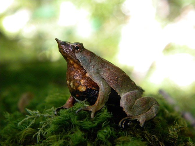
It is not much larger than a coin, and isn’t much to look at. But this tiny frog is special enough that David Attenborough picked it as one of ten chosen species to be in his imaginary anti-extinction ark. Part of the interest comes from history: how many animals can claim to have been discovered -and drawn- by Charles Darwin? The answer is, of course, quite a few, but it is not easy to find out exactly how many! Darwin’s Galapagos finches are not included: they were already known, and in fact it was a local inhabitant of the Galapagos who told Darwin that his finches with different beaks each came from a different island – Darwin, not familiar with the area, had not realized this. It is easier to know how many species have been named after Darwin: the total stands at 301 (including a lot of insects). Darwin’s frog has the distinction of being on both lists. Charles Darwin discovered it in December 1834, in the evergreen rain forests on Chiloé island, Chile, on his second visit there. He did not like the place, because (as he wrote), it never stopped raining! It didn’t bother the frog.
Darwin’s frog lives happily in these temperate rain forests of southern Chile. Darwin’s rain comes from the perpetual stream of low-pressure systems of the roaring forties, which hit the Southern Andes mountains and have the water (lots of it) squeezed out of them. Darwin described the difficulties of traveling in the area: walking through the forest meant climbing through and over fallen trees, many of which would disintegrate under your feet making you sink knee-deep into the rotten wood. He wrote how the trees and vegetation were so thick that their feet hardly ever touched the ground. These dead, (glorious) fallen trees, fully covered in moss, made much of the area impassable. They finally gave up and returned to the trenches Beagle.
In this green tree morass, the frog hardly stood out. It is tiny, at 3 centimeters across (just over one inch, if your metrics doesn’t use metrics). The green and/or brown colouring provides superb camouflage, to the point that the only way to see the frog, even when standing next to it, is when it moves. The colouring is variable: seen from above it can range from uniformly green to uniformly brown, and anything in between, but it fits the boggy surroundings covered in moss and dead leaves well: it looks much like one of those leaves. The underside of the frog is very different, and is a mess of black and white blotches. When threatened, it turns upside-down, shows this black-and white underside, and plays dead; it may also jump in the stream and do the same while floating. But it has one disadvantage in the hiding game: it is loud – at least the males are. The frogs are diurnal, but the males sing at night, mainly in the breeding season which runs from October to March. And it is these males who show extraordinary behaviour. They incubate the live-born froglets in their mouth (the vocal sacks, to be precise), and spit them out only when they reach 1 cm in size. It shares this behaviour with sea horses, but no other land-based vertebrate does this. Imagine, carrying 10-15 froglets inside you each of which is a third of your body length! All the internal organs have to move out of the way – and imagine the wriggling! The male must be so glad to finally be rid of them. The froglets have no gills and absorb secretions supplied by the male inside its vocal sac: they could not survive outside the mouth of daddy. It is a well evolved, but very rare, evolutionary strategy.

istorical distribution range map for Darwin’s frogs
Blue, Northern Darwin’s frog (Rhinoderma rufum); red, Southern Darwin’s frog (Rhinoderma darwinii); yellow, area of sympatry. https://doi.org/10.1371/journal.pone.0066957.g002
Unlike Darwin, this frog really likes humidity. It lives along slow, cool streams (temperatures between 5 and 20 C) and in forest bogs where the humidity never drops below 70%, in the evergreen rain forests of southern Chile and nearby Argentina.
A surprise was that Darwin’s frog turned out to be two different species: Rhinoderma darwinii (the southern Darwin’s frog) and R. rufum (the northern Darwin’s frog). The latter has not been found in the wild for considerable time, and is now believed to have gone extinct around 1982. It was only recognized as a separate species in 1975, so its independence (frexit) was short-lived. It differed from R. darwinii in a few aspects, including a more northerly distribution and the fact that it incubated only to the larval stage whereas R. darwinii waits until the larvae have become froglets. But R. rufum is no more, and R. darwinii is only found in severely fragmented populations. Originally, they were found along the entire southern Chilean coastal forest. Much of this original forest no longer exists, ands has been replaced by pine and eucalyptus plantations. This certainly contributed strongly to the decline, as all surviving populations are in native forest. But Darwin’s frog is also in rapid decline in protected parks and reserves. By 2010 only around 60 fragmented populations were known, each counting no more than 100 individuals.
A pregnant male Darwin’s frog
There has been an illegal pet trade in Darwin’s frogs, mainly to the US, and together with the disappearance of its natural habitat this will have contributed to the disappearance of some populations. But the fungus which has devastated amphibians elsewhere has been found in the remaining populations and it is believed to be a major cause of the high mortality. The fungus is Batrachochytrium dendrobatidis, and the fatal disease it causes is called chytridiomycosis. The decline of Darwin’s frog has also occurred in places which are inaccessible and have little human impact, which suggests that this fungus may be to blame. At the current rate of decline, Darwin’s frog could be extinct within 15 years, after which no land-living mouth-brooding vertebrate will have survived.
But there is another aspect. It lives in an area peppered with volcanoes. One can imagine that a frog which likes a bog does not enjoy ashy and pyroclastic eruptions. And this area has had two major eruptions which coincided with the frog’s decline, only a few years apart. Is it possible that this is one species at risk of volcanic extinction? The two eruptions were Chaiten 2008, and Puyehue 2011. Let’s have a look – preferably from a dry place at a safe distance.

Extant populations of the Southern Darwin’s frog (Rhinoderma darwinii) in south Chile and Argentina. Red circles, studied populations; blue circles, species identified, but population status uncertain; black triangles and yellow areas, recent volcanic eruptions and their areas of direct influence. https://doi.org/10.1371/journal.pone.0066957.g003
Chaiten
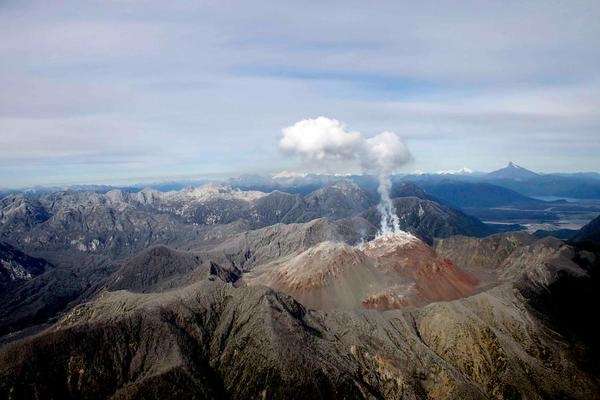
Chaiten volcano
The first activity of the 980 meter high Chaiten volcano came on 30 April 2008, with a series of earthquakes. Chaiten was not considered an active volcano, and there was little direct monitoring: in consequence these warnings were only noticed after the fact. The first earthquakes detected in real time followed, and 20 hours later the inhabitants of the local town (also called Chaiten, located on the coast) began to feel the quakes which now reached M5. Only four hours after the earthquakes began to be felt, at 23:38pm on May 1, the mountain exploded. The magma had moved from the chamber 5 kilometers below to the surface in only 4 hours, at almost Hekla-like speed. The stratospheric eruption column was maintained for 6 hours: it reached a height of 19 km. Afterwards, a 200-meter crater was reported.
It was a rhyolitic eruption. These are uncommon: there had been only two similar eruptions in the entire 20th century, St Andrew Strait volcano in 1953 and Novarupta in 1912. And the explosion had come as a surprise, since Chaiten had not been active for many centuries, possibly over 5,000 years. (There was a possible eruption in the 17th century.) Before the eruption the volcano had a caldera, 2.5 by 4 km, with a central dome. This dome exploded in the huge eruption. The Chilean government ordered a full evacuation out to 50 kilometers from the volcano. This may have saved significant lives: the town of Chaiten initially escaped the brunt of the eruption, but was later fully destroyed by lahars.
Further significant eruptions occurred on May 3-5, followed by a very large explosion on May 6 with ash to 20 km height. This event left a crater 800 meter in size. A third major explosion followed on May 7 but this was poorly observed due to the poor weather. Pyroclastic flows destroyed the 2500 hectares of forest on the northern flank of the volcano, either on May 6 or 7. These flows snapped off trees meters above the ground, but appear not to have been particularly hot as the leaves did not burn. This points at the destruction of the old lava dome as the source.
A new dome developed after May 12. This became unstable, and finally collapsed on Feb 19, 2009, with pyroclastic flows reaching 5 km away to the south. After this, minor activity continued until 2011.
The ash of the eruption was blown to the east, with each of the three main events covering a slightly different area. 65 km away, at the Argentinian border, a thickness of 30 cm was measured. Flights were disrupted over southern Chile and Argentina, and one aircraft turbine was badly damaged when flying into an ash cloud. The climate impact was limited, as the rhyolite contained little sulfur. But the ash covered a large area, as became evident from subsequent satellite images. Initial measurements came up with very high eruption volumes, but detailed measurements later brought this down to 0.5-1 km3 of ash: a high VEI4. The ash volume was not extreme for a rhyolitic explosion, but because of the changes of the wind the area affected by the ash was large. The coastal forest was little affected because of the prevailing westerly winds, but forests near Chaiten were covered in deep ash.
Puyehue-Cordon Caulle
The name needs some explaining. The volcano is called Puyehue. It has a fissure called Cordon Caulle, and together they make up the Puyehuhe-Cordon Caulle volcanic complex, awkwardly abbreviated as PCCVC. (There is even a third member of the clan, Cordillera Nevada, which has collapsed and formed a large caldera. It is located at far end of Cordon Caulle.) Puyehue is a 2.2-km high stratocone with a 2.5-km wide, 250 meter deep crater, but it appears to be currently inactive and hasn’t erupted for over a thousand years. The 20-km long ridge of Cordon Caulle, in contrast, is a frequent eruptor, with 7 recorded events during the 20th century. The fissure has clearly managed to capture the magma conduit and is currently starving the summit of lava. One day the summit will fight back and come to life again.
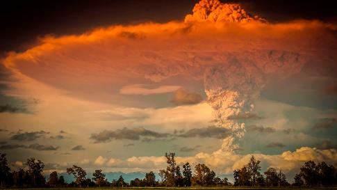
It was one of the most photogenic eruptions of the 21st century. In contrast to Chaiten, there had been considerable warning of the eruption. Because of its history, the volcano was probably well monitored. Earthquakes started late April 2011, and build up during May. On June 3, the size of the earthquakes sharply increased and the next day they reached M4. The explosion began on June 4, at 14:45 Chilean time, from a new vent 7 kilometers north-northwest of Puyehue. Like Chaiten, this was a rare rhyolitic explosion. The first plinian eruption lasted an amazing 27 hours, during which the ash cloud reached 14 km in height and began to spread eastward, reaching the Atlantic Ocean and even the now inappropriately named Buenos Aires further north. Over the next two weeks, the ash cloud circled the (southern) globe. Flights were canceled from Argentina to New Zealand, and eventually also in Chile when the ash cloud reached it again on June 18. 3,500 people were evacuated, some by force. This worked: there were no casualties, even though there were extensive (and hot) pyroclastic flows in the valleys to the north reaching 12 km from the vent. The explosions continued, and although the column now only reached 10 km, more ash was still being added to the eruption volume. An effusive eruption began on June 20: it eventually covered 7 km2. The explosions continued until April 2012 but did not reach the strength of the initial eruptions.
Subsequent research identified 13 different layers in the ejecta. The total volume of the ash remains disputed. The lowest estimate is close to 0.2 km3, whilst the highest is around 2.5 km3. The ash was distributed over a large area covering much of Patagonia, and this causes uncertainties in extrapolating the total volume from individual measurements. What (to me) appears to be the best established number for the first eruption is 0.75 km3; later eruptions added about 0.3 km3, and the pyroclastic flows had a volume of 0.08 km3 which would give a total number around 1.2 km3. This was a VEI5, so far the largest explosive eruption of the 21st century. Because the explosions lasted such a long time, changes in the wind ensured that a large area, mainly in Argentina, was affected. The deepest ash layers were 50 cm thick.

Divers of the Prefectura Naval Argentina inspect the Rio Limay, covered with pumice and ash from Chile’s Puyehue-Cordon Caulle volcano chain at the mountain resort of San Carlos de Bariloche in Argentina, on June 16, 2011. Source: theatlantic.com
Living with ash
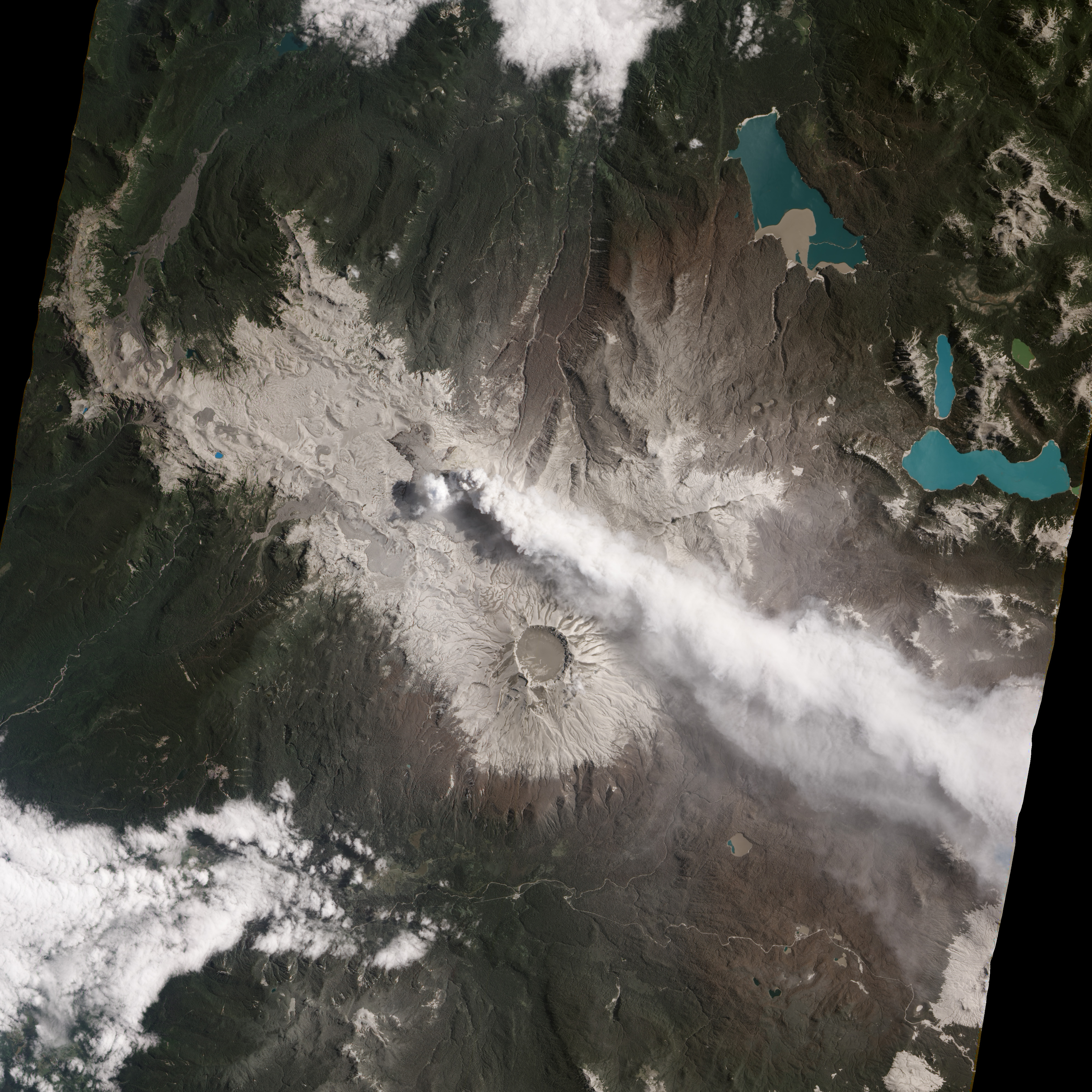
Image taken by NASA Earth Observing-1 satellite on January 26, 2012, showing the ash cover around Puyehuhe-Cordon Caulle
Volcanic eruptions can be bad for wild life, but we rarely know how bad. The only one for which detailed estimates are available is Mt St Helens: The Washington Department of Game (note the name) estimated that 11,000 hares, 6,000 deer, 5,200 elk, 1,400 coyotes, 300 bobcats, 200 black bears, and 15 mountain lions died during the eruption. The one volcanologist who sadly died whilst observing the eruption, David Johnston, was not listed. The impact on frogs was also not listed, probably because (like volcanologists) they are not a well-known game species. The later effects of the ash were not included in the numbers. Volcanic ash is known to cause silicosis, resulting in lung impairment and scarring. Eyes can also be damaged. Sulfur gases associated with the ash are dangerous, with birds particularly sensitive, and water-based animals can be affected by acidification of pools and streams. After an ashy eruption, little vegetation is left and the remaining animals can face starvation. Thinner ash layers are mainly a problem for deeper grazing animals such as sheep and deer. Cattle tend to go for top growth and are less affected, but deep ash layers are problematic for both. Volcanic ash can also cause fatal gastrointestinal blockages. The sharpness of the ash particles can kill insects, and this affects the animals feeding on them, including birds – and frogs. Ash is not good. The final wild-life toll of St Helens must have been considerable higher than those caused directly by the eruption.
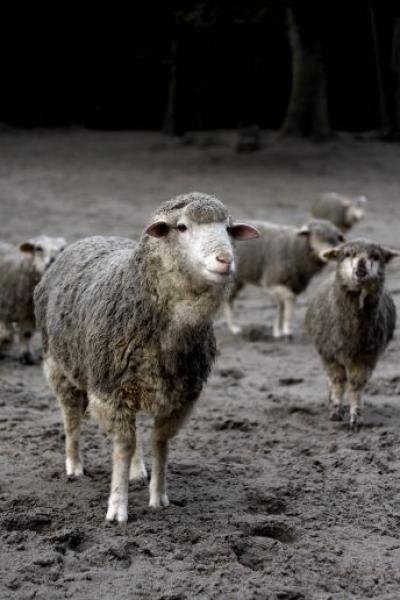
Argentinian sheep covered in ash from Puyehue
Regarding Chaiten and Puyehue-Cordón Caulle, rhyolitic eruptions tend to be sulfur-poor, so for both Chilean eruptions the ash itself was the main danger, both from direct and indirect effects. Large rhyolitic explosions are not all that common, so having two in close proximity within a few years is a notable event. The rhyolitic ash of both eruptions was somewhat different. Puyehue-Cordón Caulle had the most significant impacts, not only because it was a bit larger with a larger depth of the ash (sufficient to kill forests) but also because of a high fluoride content of the ejecta. In addition to the effects listed above, sheep, horses and cattle succumbed to fluorosis; it may be expected that wild animals were also impacted. Frogs are known to be sensitive to fluoride: in New Zealand, native frogs developed osteofluorosis after being exposed to fluoridated water.
Frogs that live in moss-covered forests with eternal rain may have trouble living in ash instead. Deep ash kills the vegetation they rely on, but also lowers the humidity as the rain which used to be caught by the vegetation now quickly drains away on the ash. This is a temporary problem: over time, the vegetation recovers and the ash becomes a fertilizer, but that may take several years. Plummeting insect population remove the major food source. Darwin’s frog has the additional problem that it is not a mover. The frogs stay within a kilometer or so of the same area, which is one of the reasons the populations have become so fragmented. When an area becomes unsuitable, the frog doesn’t move on – it dies out. In due course it may be replaced (slowly) from populations surviving elsewhere, but with such poor migrators that takes time and it requires that these other populations exist and thrive.
One of the remaining R. darwinii populations was located 22 km south-west of Chaiten. In the year after the eruption, the frog was no longer recorded there: it had not survived the eruption. There were two populations near Puyehuhe-Cordon Caulle: one of these disappeared completely. The westerly winds helped the frog, as it blew the ejecta away from the coastal forests. But some of the few surviving populations were too close to be saved by the wind.
Future of the frog

Darwin’s frog, at least the surviving one of the pair of species, is highly threatened. The rapid removal of their natural habitat probably initiated the decline. The volcanic eruptions have not helped, and have reduced the range of Darwin’s frog further. But the dominant threat is currently the spread of chytridiomycosis. Mortality among the young due to the chytridiomycosis disease can reach over 50%. Models show that this will lead to extinction of small populations. Infectious diseases normally die out before the species that acts as their host can go extinct, but this fungus does not obey these statistics, because it has other hosts available.
Chytridiomycosis was first found in Queensland, Australia, in 1993, but was already rapidly spreading around the globe. The disease is now believed to have entered Chile already in the 1970’s. How it arrived is not known, but the main suspect is the African clawed frog which appeared around this time. It was imported because at the time it was used in pregnancy tests: a bit of urine was injected into their hind leg, and if this caused the frog to lay its eggs, the urine was from a pregnant woman. In the 1970’s, better and simpler tests became available and hospitals released their African clawed frogs into the wild. The discovery that these African frogs carried chytridiomycosis, without themselves being negatively affected, came in 2006. It would be sobering if those old tests for human reproduction were indeed the cause of the current wave of amphibian extinctions. One third of all amphibian species are under threat, and in Panama alone 100 different species may already have been lost. This is truly the revenge of the frog.
The fate of Darwin’s frog has become well publicised, by David Attenborough and others. Action is being taken, and several captive breeding programs were started in Chile during the ‘year of the frog’ in 2008. The frogs do breed in captivity but are just as susceptible to chytridiomycosis: an early attempt to breed the frogs in Germany reportedly failed when all 30 frogs died from this infection. Attempts are continuing: http://reportagen.frogs-friends.org/en/darwins-frog/cooperation. A collaboration between Concepcion and Leipzig has been particularly successful. But not without problems. Five European zoos worked together to obtain viable groups of Darwin’s frogs, but during the wait for export licenses (a long process for endangered species), in 2016 a disease affected the Concepcion program leaving only 20 surviving frogs. The disease was finally eradicated in 2017, and as of autumn 2018 the wait was still on for enough young frogs to grow up to try again for export licenses.
Darwin’s frog is now red-listed as threatened with extinction. Small populations can be at risk of many factors and the final cause of extinction may be an accident – a bad storm, a forest fire, or an eruption. The decline makes them vulnerable. In this way, the two large eruptions contributed to the threat of extinction: they have removed 2 or 3 of the remaining populations. Under normal circumstances, the frog would happily have survived elsewhere and over time repopulated the devastated areas. That recovery is not an option under the current circumstances. The resilience isn’t there.
But could previous volcanic eruptions have had any significant effect on Darwin’s frog? That is very difficult to know, especially with an animal that fossilizes rather reluctantly. It turns out that there have been many previous eruptions, and the 2008/2011 events were not particularly large for the area. There are many older tephra layers around Puyehue, and some are surprisingly recent. Five such layers (pre-1900) date from the holocene and are post-glacial. They range in thickness from tens of centimeters to 1-2 meters. The layers are dated at 10.5 ka BP, 7 ka, 2.5 ka, 1.9 ka and 1.1 ka. The last one erupted between 1.7 and 3 km3 (DRE) from Puyehue, 2 to 3 times larger than then 2011 eruption. The 1.9 ka event (dated to 1932+-68 BP) was the largest of the series, at 8 km3 DRE. It did not come from Puyehue but was from the Antillanca volcano, 20 kilometer south where it formed a 4.5-km wide caldera. (Antillanca caldera is now home to a new volcano, called Casablanca. It is one of the fastest growing volcanos in the southern Andes.) Eruptions with volumes near the 1 km3 mark may be quite common: they happened here in 2011, 1960 (triggered by the M9.5 earthquake) and in 1921. But all five layers listed above are larger than this.

Casablanca volcano, near Puyehue
The Chaiten area similarly shows evidence of past, large eruptions. There is a second volcano in the area, Michinmahuida, located 20 km east of Chaiten. It differs from Chaiten in its composition: whereas Chaiten produces rhyolite (it is the only volcano in its surroundings to do so), Michinmahuida produces andesite and dacite. Both volcanoes have produced holocene ejecta blankets. The most significant one is the Amarillo ignimbrite, dated to 10.5 ka BP, and reaching a thickness of 80 meters. This eruption may have formed the Michinmahuida caldera. The tephra volume (non-compacted) is 10 km3 at minimum. The main ignimbrite is only found around Michinmahuida but it appears to be associated with tephra layers elsewhere, including on Darwin’s least-favourite island, Chiloé, the stronghold of the frog named after him.
Michinmahuida had another eruption around 7.3 ka BP, producing around 2 km3. The Chaiten eruption at 9.5 ka BP left tephra layers 70-cm thick, and indicate a tephra volume of 5.5 km3. It was followed by one around 4.5 ka BP which may have been two separate events, producing 4.7 km3 of tephra and leaving meters-thick pyroclastic deposits. There may have been another eruption similar in size to the 2008 event which has been dated to the 17th century.
The conclusion is that both locations have shown eruptions much larger than those of 2008 and 2011. These must have devastated much of the surrounding area. They clearly did not lead to extinction of Darwin’s frog, but locally, they would have had a significant impact. One can speculate whether a very large eruption could have lead to to the separation of the northern and southern Darwin’s frog into two different species.
What is the future of Darwin’s frog? It looks bleak. The only hope appears to be either a disease-free and long-term funded captive breeding program, or the evolution of the fungus into one that is less lethal. Neither hope seems well founded. If the models are correct, we could loose the only land-based vertebrate mouth-breeding species within 15 years. There are volcanoes in the area which could give it its final push over the edge. But it looks like those won’t be needed. For this frog, extinction is happening too fast already.
Volcanoes do not make species extinct. On the other hand, they don’t need to. We can do it quite well without their help, and with no one else to blame. Darwin opened for us the book of evolution. It is filled with wonders. One of those wonders could be about to disappear, and it may never re-evolve. In Darwin’s cafe, is it time for last orders?
Albert, February 2019

References:
The Population Decline and Extinction of Darwin’s Frogs.
Claudio Soto-Azat ,et al., 2013, PLoS ONE 8(6): e66957. https://doi.org/10.1371/journal.pone.0066957
Cryptic disease-induced mortality may cause host extinction in an apparently stable host–parasite system. Andrés Valenzuela-Sánchez, et al. 2017, Proceedings of the Royal Society B: Biological Sciences, 284 (1863): 20171176 DOI: 10.1098/rspb.2017.1176
Complex dynamics of small-moderate volcanic events: the example of the 2011 rhyolitic Cordon Caulle eruption, Chile. Marco Pistolesi et al., 2015, Bulletin of Volcanology 77:3. https://link.springer.com/article/10.1007%2Fs00445-014-0898-3
Holocene tephra succession of Puyehue-Cordon Caulle and Antillanca/Casablanca volcanic complexes, southern Andes. J.A. Naranjo et al. 2017, Journal of Volcanology and Geothermal Research, 332, 109-128. https://www.sciencedirect.com/science/article/abs/pii/S0377027316301986
Holocene record of large explosive eruptions from Chaitén and Michinmahuida Volcanoes, Chile. Álvaro Amigo et al., 2013, Andean Geology 40: 227-248. http://www.andeangeology.cl/index.php/revista1/article/viewFile/V40n2-a03/pdf


Found a great piece of research that goes back to the discussion from the last article.
https://www.researchgate.net/profile/Michael_Sigl/publication/279965759_Timing_and_climate_forcing_of_volcanic_eruptions_for_the_past_2500_years/links/564597fb08ae9f9c13e5f3e4/Timing-and-climate-forcing-of-volcanic-eruptions-for-the-past-2-500-years.pdf
The 536 spike was from a NH-only event followed in 339 or 540 with a bi-polar sulfur spike (either from a a single tropical event or simultaneous NH and SH events).
A shot across the bow?
https://www.universityofcalifornia.edu/press-room/uc-terminates-subscriptions-worlds-largest-scientific-publisher-push-open-access-publicly
Research should be open access. It amazes me that people do research and publish the result in a journal which people can’t read. What is the point?
Money money money…
… or, it is dubious research that can not stand on it’s own merits.
Can’t have the general public come along and point out the errors ya know.
Full disclosure. I am a strong advocate of public access to documentation. Much of what the commenters of volcanocafe use and refer to about volcanoes come from research papers. It allows us to have semi-intelligent conversations about them
Side note. One of the fastest ways to generate suspicions about research findings, is to hide the sources and methods behind that research.
In my opinion, if it can’t be verified, it PROBABLY isn’t worth looking at.
Hi Geolurking, I think there is a missunderstanding here. As an author you can either publish for free behind a paywall or open acess, but then you or your institution has to pay a fee for it. So then part of the tax payers money doesn’t end in research, but in publication fees. So the publisher gets it’s money in any way, either from the author, or the reader. And as an author you don’t get money in either way.
————
“Can’t have the general public come along and point out the errors ya know.”
I don’t want to sound presumptuous, but in most cases “the general public” doesn’t understand the publication which would be prerequisite to pointing out errors. And the peers, who do understand, mostly do have access via their institution.
———–
This is a good decision of UC. They are large enough, that it might have an impact.
This was put in the ‘for approval’ queue. Future comments should appear without delay – admin
Yes, there are two different aspects playing in this situation. Publishers make their money mainly from library subscriptions. The large companies sell bundles – the libraries can’t pick individual journals, but have to buy a large set, including many journals no one cares about. The prices for these bundles increase every year. The typical profit margin of the publishers is 40%(!)
You can also ‘buy’ access to an individual paper but no one should ever do that. The author of the paper will happily send you the paper for free. In some fields (physics mainly) preprints of all papers are available as well, but geology has not gone down that route.
The author also pays a publication charge, depending on the journal (some charge, some do not). And the author has to sign over the copyright. Scientists get a very bad deal.
Open access means that the journal gives free access to the on-line paper. They charge the author for this: typically a few thousand dollar per paper. But they still sell the subscriptions as well, and this is where the main argument has been. Libraries do not want to pay for papers they have already paid for. Publishers just want to make more money.
There are more and more journals which are full open access. However, most of these are predatory, aimed only at getting money from the scientists. A new class of open access journals is beginning to appear, run by scientists and these tend to be very cheap (maybe 100 dollar per paper) and freely accessible without subscriptions. But governments judge research by the prestige of the journal it is published in. These new journals have no ‘prestige factor’ yet, and so people are punished for publishing there.
The EU now requires open access for all EU-funded research. But it still pushes towards publication in traditional journals, meaning at a high cost.
Scientific publishers have a turn-over of 7.5 billion euros per year, around 1 LHC each year. This is roughly 4000 euro per article. To maintain the preprint servers used in physics, with 140,000 papers per year, costs around 15 euro per paper (all its costs are paid by a consortium of universities). Tells you all.
An intermediate system could be devised, where the publishers and preprint archives work together. This is estimated to cost 1000-2000 euro per paper, saving universities billions. But which company willingly gives up profit margins of 40%?
The kind of dispute between UC and Elsevier is not uncommon and normally ends with the publisher taking the price down a bit. However, we don’t know this as there are non-disclosure agreements involved and libraries are not allowed to divulge the cost of their subscription. Every university pays a different amount but how different we don’t know.
That’s very interesting. I’ve always thought that publicly funded research should be available to the public who pays for it, warts and all. A big part of real science is the ability to scrutinize the research, and defend it. I think the publishing companies may have shot themselves in the foot.
I’m actually quite okay with the “foot shooting.”
My analogy of their business model is like someone trying to charge a toll for a road built by the government on taxpayer money.
I consider them to be no better than parasites. And like all parasites, the worst of them kill off the host and eventually become extinct. This is essentially the University scratching at a flea. It is very important for other researchers and universities to sit up and take notice. If the government gets involved, it could mean that some monetary resources could easily dry up, hindering important research.
In fairness, the biologist who put the shrimp on the treadmill states that he used his own money for the treadmill.
GL Note: I don’t know if Amazon carries these.
…and I wonder if he accounted for the lack of resistance from the water as he was measuring the metabolism of the shrimp. The shrimp is not moving through water, it’s stationary compared to it’s motion…
Don’t get me started on tolls! I live in (very) SE Virginia and they’ve tolled everything over the last several years. We’re waterlocked, and pretty much can’t get out of the area without paying a toll or going way out of your way to bypass. I-64 to Richmond and beyond is still fee, but they’re building tolled express lanes.
Sounds like New Jersey. From being stationed there, I came to the conclusion that you can NOT get out of the state without paying. GW bridge, free to go into Jersey, Toll to get out. The same up in Trenton. I mentioned this to a freind of mine who grew up there and he cheerily quipped that there was a non toll bridge about 45 miles up a back road north of Trenton.
Locally, they added a new bridge across the bay to access the peninsula that Gulf Breeze is on and were alarmed that the tolls were not covering the cost of the toll staff. They hired some consultants from “North East” to advise and study the problem. The solution? Raise the toll. Hwy98 is more convenient and faster, unless you want to quickly get to the east of Gulf Breeze…. in that case, I just use Hwy 87 and come out at Holly-Navarre. In both cases, it’s easier than that @#$ bridge.
Now, the mid-bay bridge to Destin, yeah, it used to be worth the toll since it came out right next to the two offices I used to service there. They raised that toll also, and there is only one office I still service. I’ll slug my way through Fort Walton Beach’s traffic. It ain’t that bad if you have a little patience and plan ahead. I’ve driven 26 foot box trucks through that area before and it’s not really a problem for me. (The large box truck really isn’t that different than a Fire Apparatus other than people are not as eager to get out of your way.)
Mobile Alabama is starting to redo some of their bridges and has explicitly stated they will be toll. I’ve already mapped out a route to bypass them if I ever have to go that direction. (I already knew the route since I am used to having a LITERAL parking lot for an interstate during hurricane evacuations.)
The (relatively) new tolled tunnels and bridges they’ve built here are all EZ-pass now, no toll booths, no choice. If you don’t bow down to EZ-pass, the plate fee is over 100% penalty. And the company is allowed to raise tolls every year for 58 (or 59, don’t remember exactly) years.
Indeed the shrimp is stationary. Same effect for treadmills where there is a slope. Its completely ineffective as no work is being done against gravity but even quite smart people think its harder with the slope set than on the level.
Its not!
Not quite true: it takes much more effort to run on a treadmill with slope. That is because you put your foot down ahead and take off below, so while on the treadmill your foot moves down hill. And you follow the foot.
In the strictest sense, no work is done because the mass winds up back where it started. Carry a 100lb box into another room, bring it back and set it where it was at, and no work was actually done… but your back and arms will tell you otherwise.
I think that is what Albert is pointing to. Your body does all the mechanics necessary to perform the task of locomotion, so you achieve the workout benefits. But in the strictest sense, no work is actually “done.”
As for the incline, you are in fact lifting your mass with each stride, so physically, you are performing more work.
And like the scampering shrimp, you are not experiencing drag so you are not working against that. For humans trotting along in air, the drag is so small that it is pretty insignificant. For the shrimp moving against the drag in water… it is high enough to where it likely would show up in the metabolism the shrimp had to use to stay in place.
Air drag is of some importance to a runner, and that is not replicated by a treadmill. Instead the treadmill is set by default as slightly inclined, to compensate. Some sports are limited by air drag: those are the ones where the records are set at altitude (long distance jump and speed skating are two examples). Others are limited by oxygen supply (cycling) where you’d rather stay at low altitude.
Except you don’t unless you have a very strange gait. Your head and shoulders do NOT move up and down (much), they stay the same height. It is quite different from doing step-ups where (done properly) your whole body is elevated, pause, and the lowered. All that happens is that you place your front foot higher and release it lower by bending the knees/hip joints. A teeny bit more work raising your foot and calf, that’s all.
Try jogging up a REAL 12 degree slope for 2km and see how different THAT feels! 12 deg is approx 1:5 so 2km means climbing 400m. Its that difference that alerted me to the fact that it wasn’t doing what it claimed!
Ideally you should have a circular track with a slope up and a slope down but I guess that takes too much space.
It certainly is possible to run with head and shoulders at constant height on an inclined treadmill. Most people don’t, and it would require conscious effort. Ultra-marathon runners do something like this: their upper body is very still while running. But normally on a treadmill, you do put in the work. It is not identical to outdoors, that is true. Also, not all treadmills are the same. I have seen two where one was a much harder work-out than the other, even though both were nominally set to the same angle.
Odd,
I’m by no means (hahaha) an ultra marathon runner but I instinctively ran (even walk) with my body pretty much level and I notice most people do, more or less. OK, some more than others.
Another difference may be that when I did start jogging again after some 40 years I found that I had to retrain so as to run on the balls of my feet because otherwise there was significant shock loading on my knees. Jogging this way was generally pretty comfortable but I had to stop due to eye operation and I have not yet restarted.
Of course, I’m not an author and know very little about publishing scientific papers, but how/where will UC publish? How many open access publishers are there, or will they start publishing on their own?
Hope other universities follows! Could be the beginning of the end for these fund eating parasites!!
Linky to UC Berkeley’s notice to faculty:
https://news.lib.berkeley.edu/elsevier-outcome
https://volcanoes.usgs.gov/observatories/hvo/hvo_volcano_watch.html
The lava delta of the fissure 8 flow will probably still be partly molten until the middle of this century, or even as late as the 2080s. The lava in other areas will probably start growing over in the next 10 years but the lava delta will still be glowing inside at that point, this is actually a very big deal as it means a littoral explosion could happen on the lava delta in 20 years time.
Kilauea’s summit plumbing is wrecked. The next magma intrusion of any size is going to be noisy and messy..
And fast, there is probably no shallow system left, only the deeper south caldera chamber, the next eruption of signifucant suze at the summit will be preceded by few long term warnibgs but for about half an hour the summit will ring like a bell abd then an eruption will start sonewhere. If sone of the shallow system still exists then it will probably be in halemaumau but otherwise jt will probably happen out if the south caldera chamber which means a ring fault eruption like 1982, 1974/71 or 1959 could happen, maybe even all of these areas at once like what could gave happened in 1790. If this happens then the eruption will probably be big, either a large intrusion into one of the rifts or a 1959 ‘red VEI 4’ with episodic huge fountains and cone building.
Turtlebirdman: USGS says that Eruptive lava temperatures of the 2018 LERZ eruption reached a maximum of approximately 1140 degrees Celsius at fissure 8
That cannot be true?
USGS says maxium temperature during Leilani eruption was 1140 C ?????
Then Holohuraun and Puu Oo was much hotter
They never say where they got that sample from, they probably didnt get it from the vent though so it makes sense that the lava would have cooled down. Based on the colour of the lava erupting from fissure 8 I would expect it to be rather hotter on eruption than 1140 C, but by the time it gets to a place where it is safe to go near it the temperature would have probably dropped a lot, this lava was in open channels not tubes, and the longest distance the lava had to flow was 14 km which is longer than most of pu’u o’os lava flows.
Dunno for sure… but it is possible that USGS used some sort of remote thermometer. I use one to check the oil temp when I’m frying a turkey. Sure, it’s not intended for food use, but I have verified it’s readings against a probe thermometer and it’s close enough for me to adjust my burners to keep it near the optimal range without fighting the probe thermometer dangling from the lid. A safer method of keeping track of the temp in my opinion. With their funding, they probably have units capable of dealing with 1200°C magma.
NOTE TO ALL; DEFROST YOUR TURKEY FIRST and keep your set-up away from the house.
Additionally, I have a set of welders gloves for handling the lid and turkey hanger+hook.
IR thermometers are two a penny and surprisingly accurate. Ahh…
Well high temp ones are a bit dearer…
2200C £115
https://www.ebay.co.uk/itm/Non-Contact-IR-Temperature-Test-Meter-Digital-Infrared-Thermometer-50C-2200C/362278944472?epid=1179937803&hash=item545981fed8:g:gx8AAOSwcoFblqXQ
Fissure 8 was same as Holuhraun around 1188 C to 1203 C max
Rather hotter than 1140 C
But USGS did sample close to fissure 8 by trowing fishing in the lava
But fissure 8 s colour as you say suggest hotter than 1140 C
You’re making a classic mistake with those temperatures: quoting them to too many significant figures. You are quoting a 15 Celcius temperature range to four significant figures (1 Celcius). You are being too precise and thus giving a false sense of the measurement. I don’t know exactly how accurate the remote-sensing temperature probes that USGS would use are, but I very, very much doubt that they would be accurate to 1 Celcius. Besides given the rate that things cool in the air when they are that hot it wouldn’t be stationary as a temperature for very long either.
I’ve brought this sort of thing up time and again. For some reason everyone in the world likes to quote to an insanely inappropriate level of significance without comprehending the level of ignorance of the actual measurement. To be honest in this case 10C is probably too high a level of accuracy but certainly more appropriate.
The thermometer is probably accurate to 1C. The lava temperature of course varies with location, and it cools as it is exposed to air. i don’t know where the measurement was taken. But HVO knows how to do this, and if they quote a fissure temperature you can assume it is correct for the lava as it comes up. If they give 1140C, that implies that they are confident to within 10C. The magma will have cooled a but as it came down the rift from the summit, so the summit reservoir will be a bit hotter.
And for those of you dragging out the Mag 6.9 near the beginning of the eruption phase…
The finite fault solution for it from your buddies at the USGS.
https://earthquake.usgs.gov/earthquakes/eventpage/hv70116556/finite-fault
The moment tensor showed it to be an oblique reverse fault event. Dunno how that works into the opening up of space for magma part of it since reverse faults are where the two sides effectively move towards each other, with one side lifting as the other side moves under.
Yes. But these do reduce the stress along the fault, making it easier for magma to push along the direction of the fault.
The fault is located between the base of the south flank and the pre-existing ocean floor, the plane dips towards the rift zone, the flank moves away from the rift zone, as it does so offshore areas of the flank are uplifted. This mechanism allows low stress to continue existing along the rift zone and intrusions of magma to follow the same path.
M7 earthquake in Peru, about 150 km north of La Paz. Probably related to the earlier one in Brazil, further north. Deep so hopefully not too much damage. The main population centres are around lake Titicaca, reasonably far from the quake centre,
Jupiter is probably one of the most disturbing places in the solar system.
Specialy the cloud free hotspots
Skies on jupiter are blue as hydrogen air scatters blue light.
The clear blue sunny hydrogen skies above a dark bottomless pit!
Thats very much the enviroment like galileo atmopsheric probe entered in.
Cloud free arera
The galileo atmopsheric probe entry arera was cloud free
There was some cirrus clouds of ammonia
but otherwise blue skies over a dark bottomless… pit
you fall and fall until you gets crushed into the depths by air pressure
Gas Giants are are disturbing…
There was moist thudnerstorm actvity 3000 km from the entry arera
The 1995 probe went down in a dry spot
Junos camera is now in souch good resolution and close orbit
Its possible to see cloud shadows on jupiter
We have some more of the deep tremor I suspect. On PPLD near the coast south of Pahala it shows strong from 10:37 utc till around 10:52. There were some deep quakes in the area but they were not in the same time frame,
2019-03-01 12:54:18 2.1 36.3
2019-03-01 06:54:34 2 35.1
2019-03-01 05:37:29 2 35
Geo is sending more rain my way so I may have to rent a pump to remove some of the excess water from our soccer fields!
Not as long as last time but this is definitely the deep tremor of magma moving up. I would like to see if CO2 emissions have declined since the eruption ended because that is the sign of deep feed and whether it has stayed constant. Apparently in 2015 there was an increase in CO2 emissions from kilauea, most likely this ultimately lead to last years eruption, as kilauea started markedly inflating then and continued until the eruption last year. If CO2 emissions have not changed from those values then the magma feed is still the same as before, meaning rather a lot higher than average. As far as I know there is no mention that the rate has changed at all, so I think after a few years it will be business as usual at kilauea.
Its so sad that Maurice and Katia Krafft died
They woud enjoy Holuhraun and Fissure 8 alot
I can imagine Katia walking in her abestos suit… at the edge of Baugur
Dwarfed by the lava fountains that go 300 m up
Maurice takes many photos of her standing infront of the fountain
Thats what they did in Krafla 1984
https://www.youtube.com/watch?v=68Ix3YIhmlI
0:59 – 1:00
The narrator of that video is irresponsible. Katia and Maurice Krafft didn’t get “too close” they got overwhelmed by a pyroclastic flow. It wasn’t any foolhardiness on their part.
Yes, this is in opposition to my “don’t be there” mantra, but they had massive amounts of experience and knew what they were doing. They weren’t like some twit on youtube desperately seeking attention.
Similarly, David A. Johnston, killed by Mt St Helens, was one of a few geologists who expected a failure mode similar to what initiated the eruption and was stationed at what was thought to be a safe distance.
“His work, and that of fellow USGS scientists convinced authorities to close Mount St. Helens to the public before the 1980 eruption.”
So all those idiots griping about the closure on national TV can thank David Johnston for helping to save their lives.
sometimes i wish we had hearts or ‘likes’ or a box to check.. agree or disagree… silence is just not enough to express that we don’t disagree. Hats off to David, and Katia and Maurice and You too, Lurk for standing up for those who cannot stand up for themselves. Best!motsfo
https://earthobservatory.nasa.gov/images/144593/the-biggest-eruption-of-2018-was-not-where-you-think
Maybe there was an actual VEI 4 last year after all. 400,000 tons of SO2 erupted in a day from ambae, which is the same as calbuco in 2015, which was a VEI 4.
I think the article itself really downplays the other eruptions a lot though, like forgetting to say sierra negra and kilauea were long lived events. Maybe in the instant they couldn’t compete but 50,000 tons a day would reach 600,000 total in 12 days, fissure 8 was 60 days, which is 3 million tons of SO2, probably 4 million tons for the whole event.
I have noticed that gas bubblng in Nyiragongos lava lake are often much smaller than than Hawaii or Erta Ale It coud be the extreme fluidity of Nyiragongos 1370 C nephelinites
the crustal plates in Nyiragongos lava lake are more numerous too
Well hotter lava will be more fluid, but it might also gave something to do with the chemistry of the lava? It also might be that lava in hawaii has more gas in it so it makes bigger fountains when it spatters. I dont know how much gas is contained in nyiragongos magma but compared to other effusive volcanoes (including its neighbor) its eruptions are generally pretty small in scale so I dont think there is nearly as high a magma flux as kilauea. The area really needs some more study but its hard to spend any length of time in the area with all the political instability.
I agree, Hawaii can be pretty rough…
Beating the stale dough again!
https://www.volcanocafe.org/michio-kaku-and-the-stale-dough/