
Evergreen forest near Bariloche, Argentina, covered in 15 centimeters of white rhyolite ash from Puyehue and lost of leaves. No longer a place for Darwin’s frog. Images from http://naturalmusing.blogspot.com/2012/01/
In our modern world, no animal has gone extinct because of a volcanic eruption – as far as we know! That should not come as a big surprise. Volcanoes tend to affect fairly small areas around them, at least regions that are much smaller than the typical areas where species live. One animal particularly at risk would be the giant tortoise of the Galapagos. If you are a tortoise, outrunning a pyroclastic flow (or even an effusive lava flow) does present a challenge. But the frequent eruptions affect only part of the islands, and enough tortoises happen to be visiting somewhere else at the moment when a Galapagos volcano erupts, following Geolurking’s advice on catastrophes (‘don’t be there’), that the species is not at risk, although individuals may be. To look at it another way, if a volcano could wipe out a species, it would already have done so and it is unlikely that that species would have had time to evolve.
It has been different in the past. The Permian extinction came close to sterilising much of the globe, and it was due to the massive flood basalt of the Siberian traps. A major flood basalt is not as harmless as a typical VEI6 or even VEI7 eruption. Dinosaurs were hit by a double blow, one of which came from above (Chicxulub) and one from below (the Deccan traps). They were unlucky. But few species experience anything more than a VEI7: flood basalt eruptions, like asteroids, are few and far between.
But in our modern world, species are not as robust as they used to be. Habitat is disappearing, and food sources have become depleted. The large majority of the animal carbon biosphere is now taken up by humanity and their cattle, leaving little for anything else. The amount of wild animal life (measured by mass) is rapidly decreasing. A species that used to exist over a large area may now only be found in one small area. And that can put it at risk of the unexpected. An inconvenient volcano, even a dime-a-dozen VEI4, could push it over the edge and into the eternal abyss of extinction. As the British say, it would be like Dunkirk without the boats. (Germans, of course, would need to find a different expression.)
Darwin’s frog

Southern Darwin’s frog
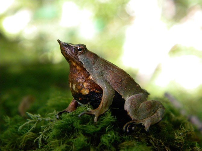
It is not much larger than a coin, and isn’t much to look at. But this tiny frog is special enough that David Attenborough picked it as one of ten chosen species to be in his imaginary anti-extinction ark. Part of the interest comes from history: how many animals can claim to have been discovered -and drawn- by Charles Darwin? The answer is, of course, quite a few, but it is not easy to find out exactly how many! Darwin’s Galapagos finches are not included: they were already known, and in fact it was a local inhabitant of the Galapagos who told Darwin that his finches with different beaks each came from a different island – Darwin, not familiar with the area, had not realized this. It is easier to know how many species have been named after Darwin: the total stands at 301 (including a lot of insects). Darwin’s frog has the distinction of being on both lists. Charles Darwin discovered it in December 1834, in the evergreen rain forests on Chiloé island, Chile, on his second visit there. He did not like the place, because (as he wrote), it never stopped raining! It didn’t bother the frog.
Darwin’s frog lives happily in these temperate rain forests of southern Chile. Darwin’s rain comes from the perpetual stream of low-pressure systems of the roaring forties, which hit the Southern Andes mountains and have the water (lots of it) squeezed out of them. Darwin described the difficulties of traveling in the area: walking through the forest meant climbing through and over fallen trees, many of which would disintegrate under your feet making you sink knee-deep into the rotten wood. He wrote how the trees and vegetation were so thick that their feet hardly ever touched the ground. These dead, (glorious) fallen trees, fully covered in moss, made much of the area impassable. They finally gave up and returned to the trenches Beagle.
In this green tree morass, the frog hardly stood out. It is tiny, at 3 centimeters across (just over one inch, if your metrics doesn’t use metrics). The green and/or brown colouring provides superb camouflage, to the point that the only way to see the frog, even when standing next to it, is when it moves. The colouring is variable: seen from above it can range from uniformly green to uniformly brown, and anything in between, but it fits the boggy surroundings covered in moss and dead leaves well: it looks much like one of those leaves. The underside of the frog is very different, and is a mess of black and white blotches. When threatened, it turns upside-down, shows this black-and white underside, and plays dead; it may also jump in the stream and do the same while floating. But it has one disadvantage in the hiding game: it is loud – at least the males are. The frogs are diurnal, but the males sing at night, mainly in the breeding season which runs from October to March. And it is these males who show extraordinary behaviour. They incubate the live-born froglets in their mouth (the vocal sacks, to be precise), and spit them out only when they reach 1 cm in size. It shares this behaviour with sea horses, but no other land-based vertebrate does this. Imagine, carrying 10-15 froglets inside you each of which is a third of your body length! All the internal organs have to move out of the way – and imagine the wriggling! The male must be so glad to finally be rid of them. The froglets have no gills and absorb secretions supplied by the male inside its vocal sac: they could not survive outside the mouth of daddy. It is a well evolved, but very rare, evolutionary strategy.

istorical distribution range map for Darwin’s frogs
Blue, Northern Darwin’s frog (Rhinoderma rufum); red, Southern Darwin’s frog (Rhinoderma darwinii); yellow, area of sympatry. https://doi.org/10.1371/journal.pone.0066957.g002
Unlike Darwin, this frog really likes humidity. It lives along slow, cool streams (temperatures between 5 and 20 C) and in forest bogs where the humidity never drops below 70%, in the evergreen rain forests of southern Chile and nearby Argentina.
A surprise was that Darwin’s frog turned out to be two different species: Rhinoderma darwinii (the southern Darwin’s frog) and R. rufum (the northern Darwin’s frog). The latter has not been found in the wild for considerable time, and is now believed to have gone extinct around 1982. It was only recognized as a separate species in 1975, so its independence (frexit) was short-lived. It differed from R. darwinii in a few aspects, including a more northerly distribution and the fact that it incubated only to the larval stage whereas R. darwinii waits until the larvae have become froglets. But R. rufum is no more, and R. darwinii is only found in severely fragmented populations. Originally, they were found along the entire southern Chilean coastal forest. Much of this original forest no longer exists, ands has been replaced by pine and eucalyptus plantations. This certainly contributed strongly to the decline, as all surviving populations are in native forest. But Darwin’s frog is also in rapid decline in protected parks and reserves. By 2010 only around 60 fragmented populations were known, each counting no more than 100 individuals.
A pregnant male Darwin’s frog
There has been an illegal pet trade in Darwin’s frogs, mainly to the US, and together with the disappearance of its natural habitat this will have contributed to the disappearance of some populations. But the fungus which has devastated amphibians elsewhere has been found in the remaining populations and it is believed to be a major cause of the high mortality. The fungus is Batrachochytrium dendrobatidis, and the fatal disease it causes is called chytridiomycosis. The decline of Darwin’s frog has also occurred in places which are inaccessible and have little human impact, which suggests that this fungus may be to blame. At the current rate of decline, Darwin’s frog could be extinct within 15 years, after which no land-living mouth-brooding vertebrate will have survived.
But there is another aspect. It lives in an area peppered with volcanoes. One can imagine that a frog which likes a bog does not enjoy ashy and pyroclastic eruptions. And this area has had two major eruptions which coincided with the frog’s decline, only a few years apart. Is it possible that this is one species at risk of volcanic extinction? The two eruptions were Chaiten 2008, and Puyehue 2011. Let’s have a look – preferably from a dry place at a safe distance.

Extant populations of the Southern Darwin’s frog (Rhinoderma darwinii) in south Chile and Argentina. Red circles, studied populations; blue circles, species identified, but population status uncertain; black triangles and yellow areas, recent volcanic eruptions and their areas of direct influence. https://doi.org/10.1371/journal.pone.0066957.g003
Chaiten
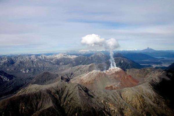
Chaiten volcano
The first activity of the 980 meter high Chaiten volcano came on 30 April 2008, with a series of earthquakes. Chaiten was not considered an active volcano, and there was little direct monitoring: in consequence these warnings were only noticed after the fact. The first earthquakes detected in real time followed, and 20 hours later the inhabitants of the local town (also called Chaiten, located on the coast) began to feel the quakes which now reached M5. Only four hours after the earthquakes began to be felt, at 23:38pm on May 1, the mountain exploded. The magma had moved from the chamber 5 kilometers below to the surface in only 4 hours, at almost Hekla-like speed. The stratospheric eruption column was maintained for 6 hours: it reached a height of 19 km. Afterwards, a 200-meter crater was reported.
It was a rhyolitic eruption. These are uncommon: there had been only two similar eruptions in the entire 20th century, St Andrew Strait volcano in 1953 and Novarupta in 1912. And the explosion had come as a surprise, since Chaiten had not been active for many centuries, possibly over 5,000 years. (There was a possible eruption in the 17th century.) Before the eruption the volcano had a caldera, 2.5 by 4 km, with a central dome. This dome exploded in the huge eruption. The Chilean government ordered a full evacuation out to 50 kilometers from the volcano. This may have saved significant lives: the town of Chaiten initially escaped the brunt of the eruption, but was later fully destroyed by lahars.
Further significant eruptions occurred on May 3-5, followed by a very large explosion on May 6 with ash to 20 km height. This event left a crater 800 meter in size. A third major explosion followed on May 7 but this was poorly observed due to the poor weather. Pyroclastic flows destroyed the 2500 hectares of forest on the northern flank of the volcano, either on May 6 or 7. These flows snapped off trees meters above the ground, but appear not to have been particularly hot as the leaves did not burn. This points at the destruction of the old lava dome as the source.
A new dome developed after May 12. This became unstable, and finally collapsed on Feb 19, 2009, with pyroclastic flows reaching 5 km away to the south. After this, minor activity continued until 2011.
The ash of the eruption was blown to the east, with each of the three main events covering a slightly different area. 65 km away, at the Argentinian border, a thickness of 30 cm was measured. Flights were disrupted over southern Chile and Argentina, and one aircraft turbine was badly damaged when flying into an ash cloud. The climate impact was limited, as the rhyolite contained little sulfur. But the ash covered a large area, as became evident from subsequent satellite images. Initial measurements came up with very high eruption volumes, but detailed measurements later brought this down to 0.5-1 km3 of ash: a high VEI4. The ash volume was not extreme for a rhyolitic explosion, but because of the changes of the wind the area affected by the ash was large. The coastal forest was little affected because of the prevailing westerly winds, but forests near Chaiten were covered in deep ash.
Puyehue-Cordon Caulle
The name needs some explaining. The volcano is called Puyehue. It has a fissure called Cordon Caulle, and together they make up the Puyehuhe-Cordon Caulle volcanic complex, awkwardly abbreviated as PCCVC. (There is even a third member of the clan, Cordillera Nevada, which has collapsed and formed a large caldera. It is located at far end of Cordon Caulle.) Puyehue is a 2.2-km high stratocone with a 2.5-km wide, 250 meter deep crater, but it appears to be currently inactive and hasn’t erupted for over a thousand years. The 20-km long ridge of Cordon Caulle, in contrast, is a frequent eruptor, with 7 recorded events during the 20th century. The fissure has clearly managed to capture the magma conduit and is currently starving the summit of lava. One day the summit will fight back and come to life again.
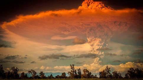
It was one of the most photogenic eruptions of the 21st century. In contrast to Chaiten, there had been considerable warning of the eruption. Because of its history, the volcano was probably well monitored. Earthquakes started late April 2011, and build up during May. On June 3, the size of the earthquakes sharply increased and the next day they reached M4. The explosion began on June 4, at 14:45 Chilean time, from a new vent 7 kilometers north-northwest of Puyehue. Like Chaiten, this was a rare rhyolitic explosion. The first plinian eruption lasted an amazing 27 hours, during which the ash cloud reached 14 km in height and began to spread eastward, reaching the Atlantic Ocean and even the now inappropriately named Buenos Aires further north. Over the next two weeks, the ash cloud circled the (southern) globe. Flights were canceled from Argentina to New Zealand, and eventually also in Chile when the ash cloud reached it again on June 18. 3,500 people were evacuated, some by force. This worked: there were no casualties, even though there were extensive (and hot) pyroclastic flows in the valleys to the north reaching 12 km from the vent. The explosions continued, and although the column now only reached 10 km, more ash was still being added to the eruption volume. An effusive eruption began on June 20: it eventually covered 7 km2. The explosions continued until April 2012 but did not reach the strength of the initial eruptions.
Subsequent research identified 13 different layers in the ejecta. The total volume of the ash remains disputed. The lowest estimate is close to 0.2 km3, whilst the highest is around 2.5 km3. The ash was distributed over a large area covering much of Patagonia, and this causes uncertainties in extrapolating the total volume from individual measurements. What (to me) appears to be the best established number for the first eruption is 0.75 km3; later eruptions added about 0.3 km3, and the pyroclastic flows had a volume of 0.08 km3 which would give a total number around 1.2 km3. This was a VEI5, so far the largest explosive eruption of the 21st century. Because the explosions lasted such a long time, changes in the wind ensured that a large area, mainly in Argentina, was affected. The deepest ash layers were 50 cm thick.

Divers of the Prefectura Naval Argentina inspect the Rio Limay, covered with pumice and ash from Chile’s Puyehue-Cordon Caulle volcano chain at the mountain resort of San Carlos de Bariloche in Argentina, on June 16, 2011. Source: theatlantic.com
Living with ash
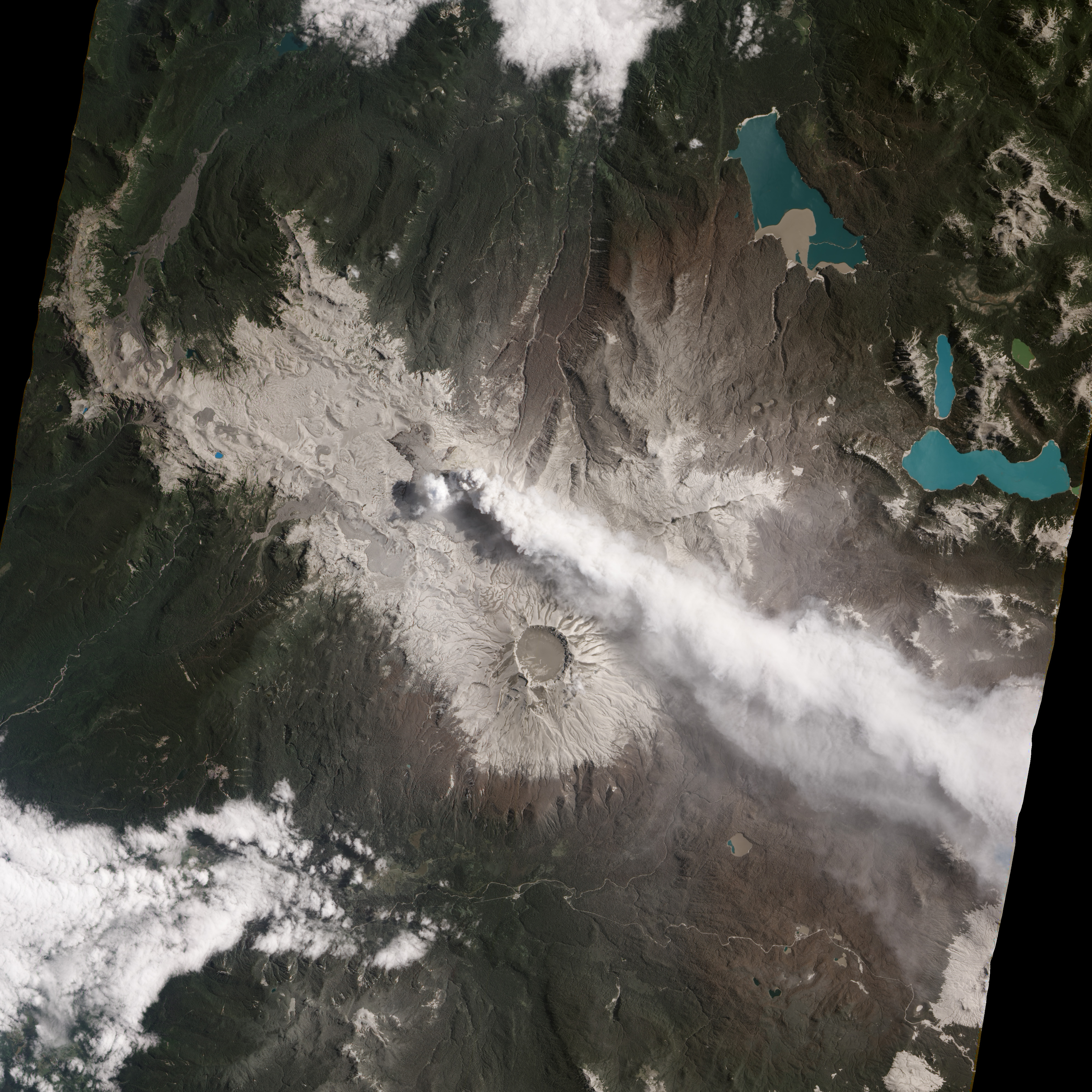
Image taken by NASA Earth Observing-1 satellite on January 26, 2012, showing the ash cover around Puyehuhe-Cordon Caulle
Volcanic eruptions can be bad for wild life, but we rarely know how bad. The only one for which detailed estimates are available is Mt St Helens: The Washington Department of Game (note the name) estimated that 11,000 hares, 6,000 deer, 5,200 elk, 1,400 coyotes, 300 bobcats, 200 black bears, and 15 mountain lions died during the eruption. The one volcanologist who sadly died whilst observing the eruption, David Johnston, was not listed. The impact on frogs was also not listed, probably because (like volcanologists) they are not a well-known game species. The later effects of the ash were not included in the numbers. Volcanic ash is known to cause silicosis, resulting in lung impairment and scarring. Eyes can also be damaged. Sulfur gases associated with the ash are dangerous, with birds particularly sensitive, and water-based animals can be affected by acidification of pools and streams. After an ashy eruption, little vegetation is left and the remaining animals can face starvation. Thinner ash layers are mainly a problem for deeper grazing animals such as sheep and deer. Cattle tend to go for top growth and are less affected, but deep ash layers are problematic for both. Volcanic ash can also cause fatal gastrointestinal blockages. The sharpness of the ash particles can kill insects, and this affects the animals feeding on them, including birds – and frogs. Ash is not good. The final wild-life toll of St Helens must have been considerable higher than those caused directly by the eruption.
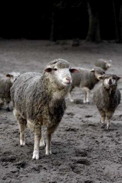
Argentinian sheep covered in ash from Puyehue
Regarding Chaiten and Puyehue-Cordón Caulle, rhyolitic eruptions tend to be sulfur-poor, so for both Chilean eruptions the ash itself was the main danger, both from direct and indirect effects. Large rhyolitic explosions are not all that common, so having two in close proximity within a few years is a notable event. The rhyolitic ash of both eruptions was somewhat different. Puyehue-Cordón Caulle had the most significant impacts, not only because it was a bit larger with a larger depth of the ash (sufficient to kill forests) but also because of a high fluoride content of the ejecta. In addition to the effects listed above, sheep, horses and cattle succumbed to fluorosis; it may be expected that wild animals were also impacted. Frogs are known to be sensitive to fluoride: in New Zealand, native frogs developed osteofluorosis after being exposed to fluoridated water.
Frogs that live in moss-covered forests with eternal rain may have trouble living in ash instead. Deep ash kills the vegetation they rely on, but also lowers the humidity as the rain which used to be caught by the vegetation now quickly drains away on the ash. This is a temporary problem: over time, the vegetation recovers and the ash becomes a fertilizer, but that may take several years. Plummeting insect population remove the major food source. Darwin’s frog has the additional problem that it is not a mover. The frogs stay within a kilometer or so of the same area, which is one of the reasons the populations have become so fragmented. When an area becomes unsuitable, the frog doesn’t move on – it dies out. In due course it may be replaced (slowly) from populations surviving elsewhere, but with such poor migrators that takes time and it requires that these other populations exist and thrive.
One of the remaining R. darwinii populations was located 22 km south-west of Chaiten. In the year after the eruption, the frog was no longer recorded there: it had not survived the eruption. There were two populations near Puyehuhe-Cordon Caulle: one of these disappeared completely. The westerly winds helped the frog, as it blew the ejecta away from the coastal forests. But some of the few surviving populations were too close to be saved by the wind.
Future of the frog

Darwin’s frog, at least the surviving one of the pair of species, is highly threatened. The rapid removal of their natural habitat probably initiated the decline. The volcanic eruptions have not helped, and have reduced the range of Darwin’s frog further. But the dominant threat is currently the spread of chytridiomycosis. Mortality among the young due to the chytridiomycosis disease can reach over 50%. Models show that this will lead to extinction of small populations. Infectious diseases normally die out before the species that acts as their host can go extinct, but this fungus does not obey these statistics, because it has other hosts available.
Chytridiomycosis was first found in Queensland, Australia, in 1993, but was already rapidly spreading around the globe. The disease is now believed to have entered Chile already in the 1970’s. How it arrived is not known, but the main suspect is the African clawed frog which appeared around this time. It was imported because at the time it was used in pregnancy tests: a bit of urine was injected into their hind leg, and if this caused the frog to lay its eggs, the urine was from a pregnant woman. In the 1970’s, better and simpler tests became available and hospitals released their African clawed frogs into the wild. The discovery that these African frogs carried chytridiomycosis, without themselves being negatively affected, came in 2006. It would be sobering if those old tests for human reproduction were indeed the cause of the current wave of amphibian extinctions. One third of all amphibian species are under threat, and in Panama alone 100 different species may already have been lost. This is truly the revenge of the frog.
The fate of Darwin’s frog has become well publicised, by David Attenborough and others. Action is being taken, and several captive breeding programs were started in Chile during the ‘year of the frog’ in 2008. The frogs do breed in captivity but are just as susceptible to chytridiomycosis: an early attempt to breed the frogs in Germany reportedly failed when all 30 frogs died from this infection. Attempts are continuing: http://reportagen.frogs-friends.org/en/darwins-frog/cooperation. A collaboration between Concepcion and Leipzig has been particularly successful. But not without problems. Five European zoos worked together to obtain viable groups of Darwin’s frogs, but during the wait for export licenses (a long process for endangered species), in 2016 a disease affected the Concepcion program leaving only 20 surviving frogs. The disease was finally eradicated in 2017, and as of autumn 2018 the wait was still on for enough young frogs to grow up to try again for export licenses.
Darwin’s frog is now red-listed as threatened with extinction. Small populations can be at risk of many factors and the final cause of extinction may be an accident – a bad storm, a forest fire, or an eruption. The decline makes them vulnerable. In this way, the two large eruptions contributed to the threat of extinction: they have removed 2 or 3 of the remaining populations. Under normal circumstances, the frog would happily have survived elsewhere and over time repopulated the devastated areas. That recovery is not an option under the current circumstances. The resilience isn’t there.
But could previous volcanic eruptions have had any significant effect on Darwin’s frog? That is very difficult to know, especially with an animal that fossilizes rather reluctantly. It turns out that there have been many previous eruptions, and the 2008/2011 events were not particularly large for the area. There are many older tephra layers around Puyehue, and some are surprisingly recent. Five such layers (pre-1900) date from the holocene and are post-glacial. They range in thickness from tens of centimeters to 1-2 meters. The layers are dated at 10.5 ka BP, 7 ka, 2.5 ka, 1.9 ka and 1.1 ka. The last one erupted between 1.7 and 3 km3 (DRE) from Puyehue, 2 to 3 times larger than then 2011 eruption. The 1.9 ka event (dated to 1932+-68 BP) was the largest of the series, at 8 km3 DRE. It did not come from Puyehue but was from the Antillanca volcano, 20 kilometer south where it formed a 4.5-km wide caldera. (Antillanca caldera is now home to a new volcano, called Casablanca. It is one of the fastest growing volcanos in the southern Andes.) Eruptions with volumes near the 1 km3 mark may be quite common: they happened here in 2011, 1960 (triggered by the M9.5 earthquake) and in 1921. But all five layers listed above are larger than this.

Casablanca volcano, near Puyehue
The Chaiten area similarly shows evidence of past, large eruptions. There is a second volcano in the area, Michinmahuida, located 20 km east of Chaiten. It differs from Chaiten in its composition: whereas Chaiten produces rhyolite (it is the only volcano in its surroundings to do so), Michinmahuida produces andesite and dacite. Both volcanoes have produced holocene ejecta blankets. The most significant one is the Amarillo ignimbrite, dated to 10.5 ka BP, and reaching a thickness of 80 meters. This eruption may have formed the Michinmahuida caldera. The tephra volume (non-compacted) is 10 km3 at minimum. The main ignimbrite is only found around Michinmahuida but it appears to be associated with tephra layers elsewhere, including on Darwin’s least-favourite island, Chiloé, the stronghold of the frog named after him.
Michinmahuida had another eruption around 7.3 ka BP, producing around 2 km3. The Chaiten eruption at 9.5 ka BP left tephra layers 70-cm thick, and indicate a tephra volume of 5.5 km3. It was followed by one around 4.5 ka BP which may have been two separate events, producing 4.7 km3 of tephra and leaving meters-thick pyroclastic deposits. There may have been another eruption similar in size to the 2008 event which has been dated to the 17th century.
The conclusion is that both locations have shown eruptions much larger than those of 2008 and 2011. These must have devastated much of the surrounding area. They clearly did not lead to extinction of Darwin’s frog, but locally, they would have had a significant impact. One can speculate whether a very large eruption could have lead to to the separation of the northern and southern Darwin’s frog into two different species.
What is the future of Darwin’s frog? It looks bleak. The only hope appears to be either a disease-free and long-term funded captive breeding program, or the evolution of the fungus into one that is less lethal. Neither hope seems well founded. If the models are correct, we could loose the only land-based vertebrate mouth-breeding species within 15 years. There are volcanoes in the area which could give it its final push over the edge. But it looks like those won’t be needed. For this frog, extinction is happening too fast already.
Volcanoes do not make species extinct. On the other hand, they don’t need to. We can do it quite well without their help, and with no one else to blame. Darwin opened for us the book of evolution. It is filled with wonders. One of those wonders could be about to disappear, and it may never re-evolve. In Darwin’s cafe, is it time for last orders?
Albert, February 2019

References:
The Population Decline and Extinction of Darwin’s Frogs.
Claudio Soto-Azat ,et al., 2013, PLoS ONE 8(6): e66957. https://doi.org/10.1371/journal.pone.0066957
Cryptic disease-induced mortality may cause host extinction in an apparently stable host–parasite system. Andrés Valenzuela-Sánchez, et al. 2017, Proceedings of the Royal Society B: Biological Sciences, 284 (1863): 20171176 DOI: 10.1098/rspb.2017.1176
Complex dynamics of small-moderate volcanic events: the example of the 2011 rhyolitic Cordon Caulle eruption, Chile. Marco Pistolesi et al., 2015, Bulletin of Volcanology 77:3. https://link.springer.com/article/10.1007%2Fs00445-014-0898-3
Holocene tephra succession of Puyehue-Cordon Caulle and Antillanca/Casablanca volcanic complexes, southern Andes. J.A. Naranjo et al. 2017, Journal of Volcanology and Geothermal Research, 332, 109-128. https://www.sciencedirect.com/science/article/abs/pii/S0377027316301986
Holocene record of large explosive eruptions from Chaitén and Michinmahuida Volcanoes, Chile. Álvaro Amigo et al., 2013, Andean Geology 40: 227-248. http://www.andeangeology.cl/index.php/revista1/article/viewFile/V40n2-a03/pdf


Magnitude: 3.0
Location: 10km S of Leilani Estates, Hawaii
Time: 2019-02-22 12:31:07 (UTC)
Depth: 1.8 km
It looks tectonic. There have a number of these along the south coast, aftershocks of the M7 in May. The Ecuador M7.5 is also visible on the seismographs
Pardon my ignorance but isn’t it very shallow for its location and magnitude?
I think the depth has been recalculated. It is now listed as 8 km.
“Imagine, carrying 10-15 froglets inside you each of which is a third of your body length! All the internal organs have to move out of the way – and imagine the wriggling! The male must be so glad to finally be rid of them. The froglets have no gills and absorb secretions supplied by the male inside its vocal sac: they could not survive outside the mouth of daddy.” The author of the article is male. Us women who have given birth probably don’t have difficulty imagining the plight of papa frog.
Guilty as charged. In some ways, papa frog may be worse off than mama human, as it carries so many huge (relatively speaking) froglets. Birth is rather easier – they are coughed out (at considerable speed). I shouldn’t comment further, for the reason you mention.
I am interested in what you think of the plight of Darwin’s frog. Is its extinction inevitable?
Amen! I thought the same thing.
OPINION: Actual extinction is probably the result of two or more concurrent/simultaneous calamities that the species could have survived if they had occurred independently.
This follows along the idea the many catastrophes as recorded in human history, are the result of a cascading chain of events that would have been insignificant had they occurred separately.
The K-T extinction was probably in progress as the Deccan Traps were slowly poisoning the biosphere… along comes the Chicxulub impactor to “seal the deal”… landing IN sulphate bearing rock.
… and the shock wave around and through the crust probably did not diminish the fissures that the Deccan Traps were erupting through. Antipodal or not. With the energy levels involved “Close Enough” seems to apply. (Approx 1.83 x 1024 Joules at impact) ← Might be less, I used a 72km/s velocity which is a bit high for objects orbiting the sun.
The asteroid that slammed into the ocean off Mexico 66 million years ago and killed off the dinosaurs probably rang the Earth like a bell, triggering volcanic eruptions around the globe that may have contributed to the devastation, according to a team of UC Berkeley geophysicists.
Specifically, the researchers argue that the impact likely triggered most of the immense eruptions of lava in India known as the Deccan Traps, explaining the “uncomfortably close” coincidence between the Deccan Traps eruptions and the impact, which has always cast doubt on the theory that the asteroid was the sole cause of the end-Cretaceous mass extinction.
“If you try to explain why the largest impact we know of in the last billion years happened within 100,000 years of these massive lava flows at Deccan … the chances of that occurring at random are minuscule,” said team leader Mark Richards, UC Berkeley professor of earth and planetary science. “It’s not a very credible coincidence.”
https://core.ac.uk/download/pdf/29419909.pdf
“chances of that occurring at random are minuscule” But still a non-zero probability.
The Deccans had been progressing along for years before the impact. My opinion is that the impact put it into overdrive.
That unfortunate (for the dinosaurs) event and that Lucy later fell out of the tree sort of puts human kind into perspective. Bad stuff happens and we lucked out becoming the beneficiaries of it.
Its astonishing to me that nobody has suggested that a meteorite caused the onset of the deccan traps. Clearly any crater would now be invisible but that the impactor was a larger earth intersecting body broken up by tidal forces resulting in multiple collisions of various sizes over many decades or even centuries seem entirely plausible to me. Any evidence should be visible on the moon which ought to have intersected its fair share.
Several studies from different groups have shown that the Deccan traps started before the impact. That argues rather strongly against the idea that the impact caused the eruption.
And I have gone through the numbers myself. The chance of a Deccan-sized eruption coinciding with a KT-sized impact since the pre-cambrian is about 50%.
Dr Bakker also argues that most of the dinos appear to be long gone by the KT, due to disease or some other catastrophe, largely because of the lack of fossils at the KT line. Basically, if the asteroid buried the beasts, there should be a world-wide plethora of bones right at the line – but there are not ANY. At all. Anywhere.
So, was it the combo of disease and some other [climatic] calamity that brought on the demise ~70 million years ago and the impactor was just coincidental [and late] to the mass extinction, or did the impactor cause the demise of the non-avian dinos and vaporized all of them everywhere – even in the oceans?
I am inclined to believe the former rather than the latter.
This is an an-going discussion. I am not too concerned about the lack of fossils at the boundary: fosilization is very rare and needs the right circumstances. Fossils can be missing just because those conditions weren’t there at that moment. The uncertainty in dates also means that any sudden decline will look like a more gradual one when using the measured (uncertain) dates: that is a well-known effect. That does not mean dinosaurs were not in trouble already before the impact: they may well have been, although the case that this was worldwide is difficult to proof. Flood basalts can be deadly: the Siberian traps are a case in point. But the Deccan traps were not on that scale. I think it would have caused a notable event in the fossil record in itself, but killing every animal larger than a small dog across the entire world may need a bit more. So I tend towards the impact being the nail in the coffin. The strangest thing is that birds, which are rather fragile creatures, survived. How did that happen?
I also lean towards the impact being the final nail the coffin.
The location (approximately 25-30 degrees south latitude) of the Deccan Traps means the SO2 swirling around would have frozen and absolutely trashed the SH for 30,000 years.
The impact does appear to have influenced the scale of the Deccan eruptions probably sending up truely stratosperic clouds for a short period that, along with the short-term fallout from the impact, finished the cooling job globally, which was too much to sustain large populations of giant reptiles.
Deccan traps stop…co2 gets released from solution in the ice and cool oceans and climate quickly shifts the opposite direction. Again, the biggest and dumbest creatues with the longest lifespans and reproductive cycles suffer the most.
i always love the “50%” call……. it either did or it didn’t….. Yes or No….. i used to always say “no” to my kids on difficult desions because i could always go back and say “yes” if i had a clear chance to consider it. my chances of saying “no” after i’d said “yes were” non-existent. 🙂 motsfo
Motsfo, I love your wisdom. I always enjoy your posts on all sites. Don’t ever stop.
@Motsfo…
I’ve been dealing with a 40+ year old teenager who hasn’t quite come to grips with the fact that menopause is just around the corner.
On the brighter side… giving the grand daughter all the candy she wants before returning her to mom is quite entertaining.
Probably the deepest quake I’ve seen reported on USGS:
M 4.1 – 152km N of Anyar, Indonesia
2019-02-23 02:18:04 (UTC)6.849°S 116.481°E
527.9 km depth
Something for Irpsit:
There is an interesting ongoing swarm south of Langjökull.
Following from the discussions on the last post, if kilauea has a volume of 11000 km3 as per that paper, then if it us 200,000 years old it has been erupting at only 0.03 km3 per year in theory. However since 1500 years ago it has produced 7 erz shields and probably a similar number of equally large or larger summit shields that merged, and going at the plausible base supply of the hotspot, and the assumption that eruption rate was pretty efficient during stable long eruptions, then at least 300 km3 of magma has been fed to the volcano in the past 1500 years. The great majority of this likely erupts at some point. This number may also be underrepresentative as the rift also spreads which requires even more, and so in the end maybe as much as another 100 km3 of magma is lost in deep storage (which if it is a single body would be about 250 meters wide at the length of the subaerial ERZ and 8 km deep/tall so actually very plausible). These volumes are rough guesses and probably maximum values but it is clear that kilauea has really radically changed in the past 1500 years, with 1/20 of its volume being formed in only 1/150th of its total age and if this much growth occured recently it makes the long term acerage before 1500 years ago an even lower number (that even then is still very high by world standards).
Never though that reducing its erupted volume to 1/5 of the original value would actually make kilauea seem even more impressive, but it highlights about 5 times better how much of a volcanic powerhouse it has become, and much more recently than I thought before too. Kilauea now is basically right about to go into full blown massive shield building to ultimately become like its neighbor. At this point geological time for kilauea is nearly on human timescales, kilauea in 2119 will be a very different place. If anything I expect thic century to be even more dynamic than 1919 to now.
If anything I expect this century to be even more dynamic than 1919 to now.
That seems a likely bet. Although Kilauea in the early 20th century was also an exciting place, I think the system is out of equilibrium after the caldera collapse. Things are unpredictable but interesting events are plausible.
It is usually when a long term trend us disturbed that a major change becomes possible.
Actually just revising, evidently the ERZ is not molten cored all the way down to kapoho, but at least down to heiheiahulu is plausible because historically this is where shields occur and these require stable conduits. The rift is also not really underlain by magma between mauna ulu a d the summit, so deep set faults and fractures between mauna ulu and heiheiahulu are most likely, which is about 20 km distance. Assuming there is potential for storage from near the base of the island at about 10 km deep there, up to 2 km deep then it is a shape with a 20 x 8 km area, which is only about 700 meters wide to store 100 km3. This is actually only about twice as wide as pu’u o’os crater, a narrower width than the bigger pit craters and far narrower than the rift zone itself.
This also wouldnt all be molten now a lot of it will be old and cooled down and some solid, and it wont be all together it will be spread over the several km width of the east rift allowing future intrusions to spread easier. All in all the volume of magma kilauea can potentially store is now an easy triple digit number, the deep rift is massive and should it ever be able to get involved with eruptive activity things could get very interesting. We might get to find out soon.
This is what a shape of about 750 meters wide by 25 km long looks like, if this is 8 km tall (basically base of the island to -2 km below the surface) then this shape can store a volume of 100 km3 of magma, and this might be underestimating significantly as the deep rift is probably wider at the base than the surface expression of the east rift is.
Honestly i was actually surprised at this, I thought a 100 km3 storage would have loked way bigger. It is pretty likely that a lot of magma also exists under the summit area too.
It is thought to be dense, largely crystallized and hardly eruptable, that explains why it doesn’t really take much part in activity only sometimes mixed as a minor component with summit fresh magma.
Most likely, but that picture was only meant to show how it is actually very plausible for kilauea to store 100 km3 of magma in the deep rift. Most likely the majority of this magma is similar to fissure 17, andesite with lots of olivine trapped inside it.
The main point being made is that the past 1500 years is likely the initial stage of kilaueas biggest growth stage, apart from 1840-1950 and a similar episode maybe 600 years earlier kilauea has been going at rates that are way higher than the necessary rates needed to explain its volume over the age it has been active. As said above I calculated kilauea to have probably been supplied with about 350-400 km3 of magma in the past 1500 years and 100 km3 of that would have been needed to fill the amount of spreading the east rift has probably done in that time.
The area in orange is also very specifically located, that section of the rift is nearly a continuous line of eruptive fissures since 1952, and both mauna ulu and the pu’u o’o complex formed here, and at the end is heiheiahulu, a deep set and large volume of hot rock and magma would allow a stable conduit to form in the way these long lived eruptions require. Even the old deep magma/crystal mush probably sometimes allows intrusions, probably continuously within the upper lengths of the rift to the mauna ulu area and occasionally further down like last year or 1840, or 1960 (or actually most eruptions in lower puna). This mushy crystal layer probably closes on the dike when it is lower pressure so that provides a mechanism to actually stop such massive eruptions, which was lacking in some of my older ideas on this.
I guess the upper part of this contains more liquid magma, and that it tends to aggregate in chambers which are where pit craters form, a new one might have formed under pu’u o’o.
400-350 km³ is a lot, using the long term rate of growth of the Big Island, 0.2 km³, for the last 1500 yrs 300 km³ should have been supplied, this is shared between Kilauea and Mauna Loa and to a small amount with Loihi and Hualalai. If we assume that 3/4 have gone to Kilauea, a number I find reasonable considering the historic activity then Kilauea might have been supplied with around 225 km³ in the last 1500 years.
The original number i found was 300 km3 just for kilauea, admitedly thus is a maximum value but it is going on the assumption that kilauea has been erupting the way it us niw for most of the past 1500 years, eg 0.2 km3 per year. That is 300 km3. As far as i can find mauna loa only intervened twice in thus time, 1840 to 1950 and another time in the area around the 1300s and probably similar time duration. Loihi us likely pretty negligible at thus stage.
The end result is that about 100 km3 of magma has been stored in kilauea begining 1500 years ago and the other 200 km3 erupted, 90% at kilauea. We also dont really know how much volume was lost to the ocean, for pu’u o’o this was a very significant factor that has the potential to nearly double its given subaerial volume. Heiheuahulu probably also had a lot of volume lost in the ocean, as did kane nui o hamo and probably the observatory overflows and south flows from aila’au (or pu’u huluhulu).
The original point still remains, kilaueas growth rate has accelerated enormously in the past 1500 years.
Even if the non avian dinosaurs surivived the meteor and flood basalts, its unlikley they coud adapt to the Paleocenes crammed global rainforest and competition from the ever sucessful mammals
And later cooling of the climate in Oligocene woud make it even harder for the dinosaurs, combined with lowering of the O2 levels. If some non avian dinosaurs surivived the Pleistocenece Ice Ages woud wipe them out and combined rise of the sillica rich grasses in Miocene that required new teeth and stomachs
At the very end of the Cretaceous the dinosaurs was in decline anyway, many groups that was diverse earlier in that era had vanished at end of the Cretaceous.
The flying petrosaurs dissapeared when the avian dinosaur birds took over in the Late Jurassic
Pterosaurs did NOT go extinct in the jurassic Jesper, and they didnt have any trouble from birds either. One of the most diverse group of big animals at the end if the cretaceous were the azdharchidae, those giant stork-like pterosayrs that some members were basically flying giraffes and which also included the great flying hell beast that was hatzegopteryx. In case you didnt know it was literally the closest thing to a real flying dragon that ever existed, it could have both eaten you whole, (easily), and still be able to fly off afterwards on its 12 meter wingspan.
T Rex and Edmontosaurus likley woud not function In the Paleocenes crammed global jungle
If these guys surivived the volcanism and the Asteorid.
Many late Cretaceous dinosaurs where quite large and lived in open forested or open forest in american and european interiors.
They woud find it tricky 64 to 59 million years ago when the world became a modern looking global tropical wet rainforest.
IF these groups surivived the KT annihilation
Albert do you think the dinosaurs woud have made it without flood basalt and meteor?
I questions that they woud
The world became very diffrent from theirs indeed around 59 million years ago and later 38 million years ago when the icehouse Earth came.
Even if the dinosaurs managed to adapt to the modern modern tropical rainforests of the Eocene
They woud face huge problems from the rise of the mammals that where growing ever more diverse and abundant.
And even harder it woud be for them when the world became drier at the end of the Eocene as it got cooler
And the death of the global rainforest
The Pleistocene Ice Ages woud likley kill them and rise of large mammals during Early Oligocene
That is the million dollar question. Dinosaurs had won one battle with the mammals already. Between 250 and 200 million years ago, mammals were the dominant animals. The extinction event 200 million years ago changed that and dinosaurs took over. I think they could well have won the second battle as well. They had grown more vulnerable as they grew large but evolution can do interesting things.
Those permian animals were not mammals, they were ‘basal’ therapsids. They were not actually very primitive but for the most part they couldn’t compete with archosaurs after the great dying took a lot of them out.
In a way if you think of mammals as the therapsid equivalent of birds to dinosaurs. Birds are dinosaurs but most dinosaurs were not birds, and mammals are therapsids but if you go back far enough there are therapsids that werent mammals. And eventually past the mid triassic there are only therapsids that werent mammals.
They were pretty similar sometimes though, a lot of later non-mammal therapsids were very big and had fur and endothermic metabolisms as well as erect limbs and recently an elephant sized dicynodont was discovered which was one of the first land animals to ever reach that size and was as big as the biggest dinosaurs of its time. Some were also apex predators even long after the great dying, a large carnivorous cynodont skull was found in south africa that belonged to something that was as big as a polar bear, and this was in the mid triassic well into the reign of the archosaurs. One species of therocephalian was even venomous to the same degree as venomous snakes and with similar adaptations. These things really need more attention, we only exist because some of them took one for the team and managed to live through the first apocalypse and they held the earth for just as long as the dinosaurs did.
And the early dinosaurs weren’t full dinosaurs yet. It was the battle between the same lineages though, and initially the mammal line did quite well. But something went wrong: in my opinion, a lack of diversification of the mammal line after 250 million years ago. It made them too vulnerable to the next extinction event.
Dinosaurs were already very diverse at the end of the triassic, and were not weird ‘proto-dinosaurs’ those existedin the early triassic and maybe even before the great dying. The earliest dinosaur that is confirmed is eoraptor at 230 mya but another animal called nyasasaurus is 248 mya and it has more in common with dinosaurs than some things that were originally considered to be actual dinosaurs did. They had already diverged into theropods and sauropodomorphs and ornithischians by the mid triassic too. Theropods also started getting bigger pretty quick there were species 7 meters long and 2 meters tall by the lare triassic. Then there is plateosaurus, a sauropodomorph, which was as big as an elephant, and the still unnamed ‘highland giant dinosaur’ from south africa that was similar to plateosaurus but way bigger and it was the biggest terrestrial animal ever when it evolved and also still to this day the biggest bipedal animal of all time. It weighed 20 tons and was 16 meters long .
Also you have the times wrong, the therapsids dominated the permian, which was before the great dying. After that archosaurs took over predatory roles and then eventually most herbivorous roles too and for the most part therapsids were marginalized though not as much as shown in walking with dinosaurs. Then when the triassic jurassic extinction happened most of these archosaurs went extinct with only the crocodile line surviving. Dinosaurs did much better and took over in the jurassic.
If dinosaurs survived even a little bit there would have been no rise of mammals, the reason birds didnt take over is because they are physically incapable of both giving birth and becoming quadrupedal, with the second one being particularly important as the biggest animals are always quadrupedal. Birds also dont have counterbalancing long tails, so they cant even get nearly as big as bipedal non-avian dinosaurs. Giving birth is also why penguins are not the main marine animal, they evolved in the late cretaceous long before marine mammals but have not changed much since the eocene because whales evolved and then later still came pinnipeds and at least one if those can give birth at sea. Mosasaurs and plesiosaurs also gave live birth at sea and had similar life cycles and probably also behavior as whales, and sea snakes today also have live birth. I dont know why archosaurs cant do it but it is something fundamental as it never happened in their entire 250 million year history while lizards have done it countless times and can even evolve a vivaparous reproductive system out of egg laying in a few generations as some lizards on one island did over the past century or so.
Non avian dinos couldn’t not lay eggs but most could still walk in a quadrupedal manner and had tails, and most also had teeth which helps a lot more than mist people think. Some birds like vultures actually have sharp keratin blades on their tongues and the roof of their mouths that function like teeth because it is better than just a beak.
Basically most non-avian dinosaurs were probably more like the big animal in their place now rather than like birds. A sauropod weing 10 tons (or 50 tons) is going to look and behave way more like an elephant that is similar size rather than a chicken just because they are technically closer related, convergent evolution.
That being said, whether any sort if large dinos would be expected to survive the deccan traps is very dubious at best, deccan was far far FAR beyond a typical flood basalt…. typical flood basalts are maybe 1000 km3 flow every 100,000 years so not too bad and certainly not extinction level (hawaii is 1000 km3 every 5000 years or so for comparison) deccan was 1000 km3 flow every few decades at its peak…
just a little bit extra, said peak just so happens to also include the actuall exact KPg boundary where cretaceous fossils disappear, one of the peak flows was that 1000 km long flow of apocalyptic proportions that covered across the entire continent, below it is cretaceous marine life and above there is none.
Deccan is like an olympus mons on earth, a 1 or 2 in a billion year event. Other flood basalts are in many ways like the basalt equivalent of VEI 8s, slow feed and then eventual breakage, deccan is like hawaii, a literal blowtorch out of the earths core…
In the far future either australia or new zealand will override hawaii, then we get the great dying version two…
It is not clear whether the peak of the Deccan eruption coincided with the impact. One study says yes, another says no.
Australia will first have to negotiate the passage of Indonesia. The Indonesian government would probably prefer to send it back.
And as for the great dying, it looks like Australia needs little help with this. World heritage protection, the Australian way: https://www.bbc.co.uk/news/newsbeat-47330830 Why does Australia hate it’s nature so much? Is it because everything is poisonous? Including its politics?
No its because our politicians have a thing for coal and think the rest of the world likes it as much as they do…
maybe they find it difficult to deal with their nature because so much of it is out of balance…. rabbits/mice/ which lack natural predators and increase with man’s willingness to grow lots of food for them. Watched a special on mice plagues in Australia (as long as i could— they are not a favorite of mine; others must come and rescue me from even the dead ones) 🙁 motsfo
However i’m the designated spider dispatcher of the family. 🙂
No rabbits and mice have many predators on australia, particularly monitor lizards and eagles which are very opportunistic, its just that they breed so fast it doesnt matter how many you kill if 2 survive it is still not over.
Actually the mice here that do plagues are a native species too. Not every native australian mammal is a marsupial.
Just to clear things up for those who are not australian, 1 no we dont hate our environment only our politicians do because they like coal more than us normal even by wirld standards 2 no we dont like them either but the only alternatives are the people who say they wont do the same thing but will anyway because money, or the people who will actually not do that but will simultaneously remove border protection and immediately cease fossil fuel burning at the same time which is really going to screw up everything trying to do it that way.
3 no we dont have more deadly animals than anywhere else, we just have animals that evolved with no primates around them until the last 80,000 years or so and therefore things are going to be a bit more scary. Realistically a bear or mountail lion, which are both known to invade suburban areas in the US with some frequency, both are way WAY more dangerous than any australian snake, just as said large mammals are realistically more dangerous than venomous snakes in their own environment. Snakes will try to bite you if you threaten them and are dumb enough to let it within striking distance (only about a meter at most and way less most of the time), and the other two are mammals in our own size range that can see us as prey, and at least a bear will probably try to kill you for existing near it and for whatever crazy reason (maybe because 4 legs vs 2 so twice the power?) they can easily easily outrun you and will kill you anyway if you try to run away and leave it alone….
This bit I honestly never understood about the rest of the worlds view on australia, it is literally the only continent where if you go outside you actually dont have to worry about potential predators unless you go near rivers at the very top and there are so many croc signs up there against doing that you have to be pretty special to do it anyway.
Why are so many Australian animals poisonous? Even that cute little platypus uses it.
And the hopping of kangaroos is also an interesting innovation, not used anywhere else. I guess Australia being so flat (your part excluded) may have played a role. Big hops can badly backfire in say the Blue Mountains. While staying in the far reaches of NSW, I went for a run. A couple of kangaroos saw me, decided that whatever I was running from must be dangerous, and joined me. It impressed with how effective their motion is. I was left standing.
One old issue that I remember from where I grew up were the Moccasins on the upper reaches of the Ross Barnett Reservoir in Mississippi when it was filling. It wasn’t uncommon to hear of a guy that shot the bottom of his boat with a shotgun after a snake fell into it.
Venomous is the correct word, and apart from the platypus everything else that uses it is also found in the rest of the world, snakes, spiders, scorpions, stingrays and many venomous fish and jellyfish are all also found in other continents or around them in the ocean.
Deccan was a big event, but not a one-in-a-billion years scale. The Ojong and the Siberian were significantly larger. It was probably more like one-in-100-million years. The Deccan hot spot must have formed after (during?) the break-up of Gondwana, as that supercontinent was parked right over the location.
No the eruption rates of the deccan traps was the bit I was talking about, volume wise it is not all that much bigger than hawaii but a large portion of it was erupted over a period of time that was as short as 30,000 years rather than millions of years. Otong java was not even close to this fast and it is not really possible to determine the age of the siberian traps lava to that degree of accuracy. The supercontinent breakup lavas were probably mostly of the slow drip feed events where 90% of the lava doesnt erupt. The first CAMP basalts likely were an exception and were fast but apart from that nothing which is why the mesozoic wasnt endless extinctions from continental breakups.
The amount of lava being erupted at deccan over its peak was equivalent to the eruption rates of the skaftar fires at full force except it never stopped for 30000 years, it was literally what the actual popular depiction of a flood basalt is. It is like erupting the entire volume of hawaii in the time since the last ice age ended…
These enormous flood basalts where caused by Superplumes
Birth of new mantle plumes
During the birth phase there is an enromous 1570 C plume head that rises towards the litospheres base.
The Central Atlantic Magmatic Province plume head may have been 3000 km wide and erupted many millions of cubic kilometers of lava on the surface ( some estimates 11 million cubic kilometers in a period of 600 000 years )
The plume head dies off and leaves a plume stem and becomes more like a normal hotspot
Just imagine Siberian Traps!
Force of the eruption sent lava fountains 3000 meters into the air
Curtains of lava fountains 600 kilometer long strecth across the horizon..
Heaven for voclanoholics
Lava sheets flows out thats as large as Scandinavia and UK
The air quality anywhere near 1500 km from fissures must been awful
Siberian Traps and central Atlantic magmatic Province
Are one of the largest basaltic events that have ever occured in the long history of the world. At least since Late Archean.
The scale of this stuff boggles the mind.
Open seas of lava 100 s of km wide and lava channels 150 meters deep and excess of 1500 kilometers long.
Aa lava sheets the size of Sweden and 50 meters thick for the very very scariest examples.
Magnificent it must have been with VEI 8+ Effusive actvity
Laki is a little fart in comparsion
Some of these flows from camp and Traps had volumes of maybe likley 12 000km3 thats 800 lakis per single eruption in the very largest cases and as quick as Laki too
Neither Otong nor Siberia were continental break-up events. (In the case of Otong one can argue about this.) There is also no evidence that there was massive inflation before the eruption: that is one of the strange things about it. It was a regular (but huge) flood basalt, not a break-up event. The main event of the Siberia traps lasted 1.1 million years. The carbon emission (plot below) suggests that the strongest phase was a fairly uniform eruption rate lasting about 100,000 years, and during the decline phase there was a sudden huge carbon spike 251.4 million years ago: whether this was a sudden re-intensification is not known. The spike may have been as rapid as 5,000 year (or faster – that can’t be seen) and coincides with the main extinction event. The events have actually been timed to very high accuracy: Burgess et al., 2014, PNAS, vol. 111, pp. 3316-3321
The eruption rates during the Deccan are under discussion. The most recent paper argues for 4 high volume events, each lasting up to 100,000 years. If you want to use 30,000 years (not excluded) you need to divide by four to account for the four phases.
So I think that you are overplaying the Deccan and significantly underplaying the Siberian. Just the extinction rate already tells you that the Siberian was a far more significant event, for whatever reason.
To add about Deccan: two of the four pulses had eruption rates that are of order 30 km3/yr, or about ten times the entire annual volcanic production on Earth at the moment (3-4 km3/yr, 75% of which is in mid-oceanic ridges). That is not extreme. It is of course possible that much higher rates were achieved during shorter periods (as in the numbers you use) but only if there were much longer periods of lower activity within these pulses. Extreme rates can be found elsewhere: a peak rate of 1 km3/day (!) has been claimed for the Roza Member of the Columbia River Basalt Group, but lasting only 7 days. And Toba did even better: 1km3 every 10 minutes for a week (!).
I was more trying to emphasise that whatever was happening at deccan was very different to whatever was going on during most of the seemingly similar sized events that accompanied the breakup of pangea. I wasnt aware if a study being done on the siberian traps that was able to get that accurate.
I think in both cases they were associated with large mantle plumes, deccan is undoubtedly linked to reunion, the siberian traps might have been formed by the iceland hotspot but also that hotspot might just nit exist anymore or was completely buried under eurasia which I think has not actually moved almost at all since then.
Apart from the CAMP basalts all the eruptions that followed new rifts opening were probably fed by low rates and slow magma accumulation. CAMP coukd have predated the actual main rifting too, in which case it could have initially been like the siberian or deccan traps except in the end pangea couldn’t handle it anymore and broke.
It is fortunate that the only current hotspot that could actually sustain a flood basalt of that proportion is as far from a continent as you can get on this planet today…
I think the Siberian traps must indeed have been a proper hot spot. There was an initial event about 5 million years earlier. That may have been the formation/arrival of the plume, and the main event came after magma accumulation below the crust reached a critical value (this was at the edge of the craton which I guess is similar to the Columbian basalt). It may not exist anymore: 250 million years is a long time. The basalts associated with continental rifting seem different, and probably slower and longer lasting. Perhaps we need to wait and see what will happen in the African rift valley! That could go either way.
The very last monster flood basalts occured somewhere between 57 to 54 million years ago
During the breakup of the North Atlantic superplume event
Just before the formation of the North Atlantic Artic – Iceland Ridge
The volume is many millions of km3
This event is now blamed for the main cause of the Paleocene – Eocene thermal maxium Co2 injections
When I means monster flood basalts
I means larger than Columbia River Flood basalts that was very small in the flood basalt world
Was TAMU Massif ever subaerial or always under water?
Probably was an island when it was active, it looks flatter near the top which is like hawaii, and given that the top of it is only a km deep even now…
If hawaii keeps getting more productive then it might make something as big as tamu massif.
If subaerial, TAMU Massif could be the basalt eruption that caused the cooling that ended the Jurrasic period.
Large flightless birds became the dominant land predators for a short time in Paleocene and Eocenes global rainforests.
For a short time the dinosaurs descendents ruled the Earth. Birds like Gastornis and others lived in North American and Northen European tropical rainforests.
These terrifying birds where top predators 59 to 47 million years ago during the supergreenhouse phase.
They where quite scary things. Gastornis where as tall as a grown man and weight almost 100 kilos I think feather and muscles, they hunted the tiny acestors Of Horses and Rhinos and elephants that where limited in size in the crammed rainforest enviroment back then.
Gastornis and its relatives had enormous beaks! These coud crush a small animals body.
Living in crammed jungles these guys silently stalked their preys and struck at ligthing speed.
Gastornis became top carnivore in Europe as sea levels where high and Europe was an island continent
Some of these birds apparently managed to survive the global cooling and rise of large mammals and evolve into the terrror birds of the miocene and pliocenes open Savannah enviroments
The group is known as Phorusrhacidae
They became scavengers as the larger predators mammals became top carnivores already in Early Oligocene as the rainforest collapse happened in late Eocene making way for more open enviroments.
The Terror birds managed to survive almost 60 million years. The onset of Ice Ages and cooling and competition from mammals killed them 1.8 million years ago leaving no relatives behind.
No that never happened, gastornis was mostly herbivorous the real predators at those times were terrestrial dinosaur toothed crocodiles. In europe there was pristichampsus which probably shoukd have been the thing they showed in walking with beasts instead of that strangely bloodthirsty gastornis that seems to have also had a feather disease…
In south america the sebecid crocodiles were the rulers of the continent until 15 million years ago, their biggest member was a monster that grew up to 9 meters long and was the biggest terresrrial carnivore on earth since the cretaceous. These thibgs had teeth so similar to tyrannosaurs that fkr decades it was cinsidered tbat non avian dinosaurs survived the KPg event in both south america and europe. That was until more fossils shiwed up. Sebecids also evolved in the jurassic and started outcompeting carnivorous dinosaurs in south america by the end of the cretaceous and then watched as the dinos disappeared.
Terror birds were carnivores but they were in no position to call themselves the true apex predator with those crocs around.
I think you need to find sources that are more updated than walking with beasts. Since then most of the things in the walking with series have been shown by later discoveries to be pretty inaccurate.
The Eocene must have been uncomfortabely hot and humid .. avarge temps near equator rised to almost 40 C and 92 to 100% humidity
Mid latitudes where 15 C warmer than today and almost similarly hot
I understands that the mammals got small to loose their heat. The Artic Ocean warmed to 23 C during PETM
One bird species was in the way of Bárcena: https://www.researchgate.net/publication/276520510_Barcena_Volcano_1952_A_60-year_report_on_the_repopulation_of_San_Benedicto_Island_Mexico_with_a_review_of_the_ecological_impacts_of_disastrous_events
Good find. Strictly speaking a race of bird rather than species but that is being picky.
🙂
The Paleocene – Eocene boundary is the warmest Earth ever been in over 150 million years
Early Eocene Fossils of North Pole Strathcona Fiord thats near the North pole and was near the North pole 55 million years ago too .. it was same polar latitude almost.
fossils of crocodiles, turtles, aligators, huge snakes, tapir like mammals,hippo look-alikes and even early primates, fan palms, svamp cypress, fig, ficus like trees, nypa palm, mangroves
Suggest near tropical conditions at the North pole back then
Tropical might be a stretch, but at least temperate is certainly possible. The SH belowb about 15 degrees south would have been a toxic frozen wasteland during the Deccan Trap eruptions. Opposite of pattern of the pleistocene ice ages which were almost entirely NH (North American and Northern Euporean events. Cold up north, hot and dry in the south as a counter-balance.
Eocene High Artic was very Subtropical
That the fossils tells us
But also keep in mind that places with lots of fossil records from large animals are also places where something likely went horribly wrong. In the normal course of business (aka the circle of life) there are not that many remnants available to be fossilized. Maybe these areas were never part of their habitat but were last islands of safety before the end.
The subtropical to tropical fossils of ellsmere island
And knowing it was the same latitude back then
And sediment cores .. pretty much confirms how extremely warm Early Eocene was
During PETM Artic ocean warmed to 23 C brief tropical in temps ( 55 to 49 million years ago )
It was on deep winter avarge never below + 14 C in air temperature during Eocene polar winter during the very height of PETM And was around 30 C in summer temps
For the High Artic
The North Pole areras remained forested until the Early pliocene. But much colder than it was in Paleocene
As co2 and temperatures keept lowering, Heavy Snows in Artic in winter likley appeared during the Miocene.. but melted each summers
Miocene poles where conifers and decideous trees
Polar Beavers and rodents and ancestors of bears lives in the cooling Artic.
By the start of the pliocene era the cold have started to kill off the polar conifers and tundra climates appeared
And ice in Greenland started to grow.
Bárðarbunga 4.2 with style.
https://www.youtube.com/watch?v=zgfvJoareCQ
Eeeewww Icelanders eats so much odd stuff
The sleeper sharks they eats… they catch it then they buries it and letting it rot for weeks
Eating rotten greenland shark thats full or ammonia and acid and hydrogen sulfides.
Its the bacteria that eats the toxins in the sharks during the fermentation process that makes the toxic meat edible.
Sleeper shark meat is poisonous to humans when it’s fresh thats why they rots it.
So, some Viking must have buried the shark for awhile, and come back, hoping for better things. It’s fermented in its own piss-coloured by-product. The shark is then… digged up and cut into pieces.
The pieces is then hanged for weeks to dry out and bacteria activity dies down.
Then the foul smelling pieces are cut into cubes and served with wine.
Its its Icelandic version of the swedish surströmming but I guess rotten ice shark is more smelly and digusting
I can asure you that the smell of swedish fermented herring “surströmming” is very pleasent compare to what fumes out of Icelandic fermented shark!! But, as for surströmming, the taste is much better than how it smells!
Oooo …….
Stuffing a person full with Rotten Shark coud be a new Icelandic Punishment for crimes like robbery and theft.
Im soure its very effective
But there is NO crime in Iceland either.
Icelanders eats so much weird stuff thats its almost funny
It’s called Hakarl and I may or may not be wrong, but part of the recipe is to bury it, pee on it and leave it for six months. Yes, I’ve smelt it. I wasn’t able to actually imbibe the cube that was offered to me, but I can confirm it smells like fishy ammonia. Oh well, when you’re starving, needs must!
The smell is the most off-putting thing about eating hákarl – unless you find the smell of ammonia appetising.
The first time we had it we were advised not to sniff as we ate, and that worked. You do have to chew it to get it down though the flavour is not unpleasant, certainly not as stomach-churnigly vile as some people make it, especially with a Brennivin chaser. Think of pungent Danish cheese (gamelost) and you’ll be in the general gastronomic area.
Just to nitpick a little: Puyehue was not a VEI-5! It was a 4+: 0.75km3 bulk deposit and then a 0.3km3 lava flow (obviously this part of the volume is not counted in the VEI scale. Plus the ash plume image at the start of the Puyehue section was from Calbuco- which was also in the same region (next to Puerto Montt) so really it was a triple-hit.
Oh two more things- the highest Chaiten plume was 30km (98,000ft). Remarkable for a relatively mild eruption- compared to the much larger Pinatubo eruption- 43km (145,000ft). Also, the 17th century Chaiten eruption is confirmed and happened around 1646 and was smaller than 2008.
I used the numbers given in the scientific papers about the ash cloud, published a few years after the events when all the data had come in. I have not seen 30 km listed anywhere: I would have strong doubts about that number. Ash can’t easily reach that high.
The numbers are in the post. The 0.75 km3 refers only to the first explosion. Ash erupted over the next two days added 0.3 km3. The lava output was not included in the numbers given. Over the first three days, this makes it a VEI5.
No the 0.3km3 was the lava flow… As for the 30km ash cloud, look at GVP.
No, this number is ash/tephra. The effusive Lava is excluded. You can find it in Pistolesi et al, listed in the references at the end of the post. The abstract of the paper states
“The lowest part of the eruptive sequence (Unit I), corresponding to the tephra emitted between 4 and 5 June, is composed of alternating lapilli layers with a total estimated volume of ca. 0.75 km3; these layers record the highest intensity phase, during which a bent-over plume dispersed tephra towards the southeast-east, with negligible up-wind sedimentation. Products emitted during 5–6 June (Unit II) signaled an abrupt shift in wind direction towards the north, leading to the deposition of a coarse ash deposit in the northern sector (ca. 0.21 km3 in volume), followed by a resumption of easterly directed winds. A third phase (Unit III) began on 7 June and resulted in tephra deposits in the eastern sector and ballistic bombs around the vent area.”
More precise numbers are in the main papers. I have included the volume of the pyroclastic flows as given in this paper, which is not part of the tephra count in the abstract. There are other numbers in the literature, as quoted in the post, going up to >2 km3, but this one seems the most careful measurement. The full eruption is a VEI5.
Having read the paper and other sources then well, it is a (low-intensity) VEI-5 after all- 1.1km3 seems about right. Plus according to VOGRIPA, the 1921 and 1960 PCC eruptions have been upgraded to VEI-4 with 0.3 and 0.25km3 respectively.
The full Kilauea paper:
https://volcanoes.usgs.gov/vsc/file_mngr/file-204/367.full.pdf
The EF1 tornado that came through Georgia early this morning passed around a mile from our house. Woke us up but until the reports starting coming out did we realize how close it was. No body hurt, mostly got trees.
http://times-herald.com/news/2019/02/tornado-touches-down-in-southeast-coweta
Yeah, I slept through that same front when it rolled through here. I figured something was up when I noticed the highly antisocial pekingese was sleeping next to the big dog on my side of the room. He hates nasty weather and will seek solace near me. Otherwise he hates me.
OO glad You are ok……. Best!motsfo… and is this early for tornadoes??
No, it’s normal. Generally this happen’s when the cold fronts are fighting with the tropical air masses.
If you really want to see the strange, you ought to see what it does to radar propegation. I used to have to run air soundings through a computer model to note where coverage vulnerabilities were at for our radars. The most interfering phenomenon are the surface ducts that show up from time to time. I have, on occasion, made radar intercepts that were well beyond the radar horizon just because of surface ducts.
Yup Hawaii is the most powerful hotspot
If it keeps increasing in output strenght the output will be so much faster than than the oceanic litosphere movement. The islands will join togther in a long hotspot arc rather than separate Islands.
This have already happened to the submarine parts of the hawaiian islands all way to maui.
The hotspot focus will form shield volcanoes 600 km wide venusian looking volcanoes in the future.
The far future of Big Islands becomes like huge flat 500 km wide shields
Thats whats going to happen if Hawaiian hotspots keeps increasing in output in the far future,
Hawaii becomes as large as Iceland with decreasing volcano sizes away from the hotspot
Just an idea of what Hawaii (and in particular kilauea) could look like in the future, maybe in 150,000 years time. Kilauea at this time is as big as mauna loa, bigger even, eruptions now sometimes reach sizes similar in scale to some of the large rifting events in Iceland, and not a year goes past without activity. The summit and rifts have slightly relocated respective to todays positions due to stress fields changing, and are aligned directly with the summit, which results in eruptions being more often of a high volume rifting fissure style than the long lived lava shields like today. Much of the puna ridge is now above sea level. Not shown here is the large shallow caldera that dominates the summit area.
By this time mauna kea and kohala are heavily eroded and hualalai is relatively smooth but ringed by sea cliffs. Mauna loa is still about the same height but nowhere near as active, erupting alkali basalt and sometimes trachyte from radial vents, and most of its southwest rift was claimed by another mass wasting event, the scar was never filled this time, and lava flows from kilauea are invading the area. Loihi is a growing but still relatively small volcano.
Yup you stole my words even
You posted a even better map of that last year with colours for each volcano
Yes I lost that map though when I got a new computer, it should still be on here somewhere though.
And Just wait until Grimsvötn – Vatnajökull does that flood shield with 6 to 10
15 to 30km3 volume flows piled up on eachother
In rapid succession
It will be awsome and ugly
The balrogs inside the glaciers are stirring
The volcano may also do a large series of ( + 2km3 ) pheratoplinian caldera eruptions
Hawaii winns .. Hawaii is my favorite volcanoes too, but its hard to live there
I will move to Iceland the next best thing
Vatnajökull is a monsterious system too
Did you knew the whole Grimsvötn – Skaftarkatlar arera have inflated around 55 centimeters since 2011
I wonder what that ammounts in magma injected
I also forgot to add that it is likely by this time the earth would have started to recover from our greenhouse emissions, which might induce another ice age and so kilauea could be heavily glaciated above maybe 3.5 km like mauna loa was in the last ice age, this might make its eruptions a lot more explosive and way bigger than implied here, really not so different to iceland all things considered.
With the possibility that haleakala was 7 km tall once, that doesnt rule out kilauea doing that by this time too, in which case the summit will be glaciated anyway and also in the death zone.
The fact a 7 km tall oceanic volcano that is already 5 km tall at sea level and growing out of the abyssal pacific is not only plausible but probably already happened is mindboggling. That is a mountain that is 15 km tall, and probably over 30 from the base of the island. If that happens then the existing surface of kilauea will be deeper underground than the full height of mauna kea today… ._.
Souch enormous Volcanic Mountains woud be impossible in Icelands litosphere
Place Big island on Iceland
And very weird things happens indeed
The whole western Vatnajökull arera may have inflated almost a meter since 2011 until today
If we thinks away the Holuhraun depressurization
I wonder what that ammounts into magma intruded
7+5=12. But this may not be relevant, as there seems to be a maximum height a mountain can achieve, and Mauna Loa and Mauna Kea seem to be at that limit. They are aided a bit by the fact that part of their bulk is below sea level, so that the water helps to carry the weight. Allowing for that, both mountains have the same height as Ojos del Salado, the highest volcano in the Andes, and if you correct for the different gravity, Olympus Mons also has this same height above the surrounding plane. Kilauea can happily grow and may get large, but if it tries to get taller than its neighbour it may find the ground sinking below its feet. At the moment Mauna Loa is growing at the same rate that it is sinking, keeping its height approximately the same. That may not be by accident.
150,000 years from now we would likely be in an ice age. Of course, at the moment 80% of the time is ice age so this is fairly safe bet. The Milankovitch cycle keeps us at the current point in the cycle for the next 60,000 years, which would probably be moderate ice age conditions (we were sliding towards that before global heating took over), followed by a brief warmer spell and a deeper ice age. 150,000 years is at a cold part in the cycle, shortly before an interglacial. Assuming nothing else changes.
Human co2 output and land use will put us back into the Early Eocene
You are however considering height above the surrounding plane for the Big Island and Olypus Mons, but height above sea level for Ojos del Salado. Nevado Ojos del Salado barely rises 2-2.5 km above surrounding areas. I don’t know if Mauna Loa is growing or sinking but the problem probably lies in Kilauea taking most magma from the hotspot, I suppose that if Mauna Loa was still the dominant volcano it would have no problem in outpacing the rate of subsidence.
Fair point about Ojos del Salado. I wasn’t sure where to take the base level. The maximum weight that can be carried depends on the strength of the rock, and the strength of the lithosphere. It is not easy to build a very large mountain!
I think the pacific plate would indeed struggle to support such a large volcano, but it has that problem with the existing islands. Kilaueas rift zone is longer than mauna loas, and most of mauna loas rift is now above sea level which to me indicates this is a typical characteristic of a mature shield. Haleakalas east rift also used to be mostly above sea level and yiu can see ut even today with the abtupt transition of smooth surface to the same sort of terrain that is on the puna ridge, and heleakalas rift is similar length to kilauea (a bit longer I think), so that is what I was basing the drawing on. I havent done the volume calculations on how much lava would be required to make kilauea that big but it is already rather a lot larger than mauna loa, and likely over 100,000 km3 if I was to guess. This is a lot but I wouldnt discount it, mauna loas total volume might be similar if you add back the material it lost in the massive landslides from its SWRZ. We will never know how big koolau or east molokai really were either.
I don’t think the Alika landslides would make much of a difference to the volume of Mauna Loa they seem rather small next to its older neighbours. Haleakala also may have had a few landslides, if you look at the ancient submerged reefs and shelves and follow them around Haleakala many suddenly get cut off by a cliff. It has lost a few blocks of its flanks, there are two options: they slided or they slumped.
Its not the volume of the slides so much but more that in each case the scar was completely filled twice which means the volume lost was replaced and so a large amount of lava was erupted without actually contributing to overall growth of the volcano in total size, and now that his has been healed a 3rd is likely in the future which I included in the picture above.
On google earth I measured the length of the volcanoes rift zones, comparing kilauea, mauna loa and haleakala. Kilauea and haleakala both have rift zones about almost exactly the same length, 185 km along the full length that they are distinguishable. Mauna loas on land rift length is similar to kilaueas, but the total active length is only 113 km, 50% shorter, and there is no evidence it was ever longer than it is now. Other volcanoes that have long rifts are kohala and east molokai, similar in length to kilauea and haleakala, and from looking at kohala, which is mostly intact below sea level, its coastal plains are very extensive almost reaching to maui nui, so it was also a giant at one time and so mauna kea growing over the top of it might have been even a lot taller than it is today. The fact mauna kea and mauna loa are within 100 meters difference is probably a coincidence.
This indicates kilauea is most likely set to grow into a true giant rather than stop at a small stage like hualalai or mauna kea did.
Here is the locations of all the rift zones of hawaiian volcanoes, the older ones are probably a bit off though, but as you can see only 3 volcanoes have rift zones longer than 150 km, haleakala, kohala and kilauea. Haleakala and kohala are giants, especially the former as you found, but for kilauea to already have such a long rift zone at this early stage in its life is a likely indication of its future. Kilauea has the potential to be much bigger than mauna loa.
It is also notable that all the volcanoes that have long rifts are all eastward oriented, with their east rifts being the longest part, and for the most part the volcanoes with southwest rifts are smaller with mauna loa being an exception. Maybe the hotspot is slightly offset to that side.
I also wonder if it is possible that mauna kea and kohala are actually fed at the same deep point, or were in their shield stages at least, but for whatever reason the original kohala center became inactive and started erupting at a slightly different location on its south flank and made mauna kea, that is to say mauna kea is a large satellite of kohala. The summits of the two volcanoes are a lot closer to each other than any of the other volcanoes in the islands are to each other, and this location change to mauna kea would explain both why mauna kea is weirdly uncharacteristic of hawaiian volcanoes and why kohala seems to have apparently gone completely extinct while haleakala is still active despite being older.
Note that the length of the rift depends on whether it extends to the east or to the west. The line of volcanoes on the east side (including Kilauea) have long rifts. The ones on the west (including Mauna Loa) have shorter ones (although still very impressive compared to typical volcanoes elsewhere).
Mauna Loa had an eruption quite close to Hilo. The rift may extend further east than it is on this drawing.
Like this, the brown marker is kohalas summit today but I think the original summit was at the top yellow marker, this is where the rift zone curves, drawing a straight line through the kohala mountain and hilo ridge they cross here. This area is also a much flatter part on the flank of mauna kea, compared to the slope to the sea or to the summit. The coastal plain of mauna kea also goes even further out from the coast now, with the depth being about 500 meters and 1 km for kohalas plain further north.
The orientation of the valleys on kohala also looks like it originally went straight to the ocean but now are on a slight angle because the original summit of kohala has been dragged down a lot.
All other volcanoes are TINY compared to Hawaii
The Puna ridge alone is larger than All other stratocones combined
Based on the gravity anomaly maps that have been made for the Big Island and areas of Maui Nui and Oahu I came up with this rift configuration by identifying the positive anomalies of rift zones and linking them to the submarine ridges.
So the main difference with your interpretation would be that I have included a few three-rifted volcanoes. In Haleakala for example the topography and bathymetry which is of pyramidal shape suggests it has 3 rifts, a strong positive gravity anomaly extending north of the volcano would indicate the location of a NRZ, which also has up to present been an alignment of eruptive vents, though it seems to have gone almost inactive with the ERZ and WRZ now dominating the activity of Haleakala. Mauna Kea also seems to have kind of conserved its three small rift zones active up to recent times. Even Kilauea seems to have had in the past a small north rift zone that is no longer active. A rift zone can shift location over the lifetime of the volcano so the ones showing in the map are the locations that for some reason or another left a stronger signal. The current NERZ of Mauna Loa does seem to extend almost down to Hilo but it does not seem that way in the bouguer gravity maps, it could be due to the low resolution of the gravity surveys, for example more recent surveys of the southwest flank of Mauna Loa located an ancient rift zone known as Ninole Hills which is completely invisible in the more general maps I was looking at. I didn’t include Mahukona in the map cause there was no data for that area. and without that it is hard to know where the summit was. I considered Penguin Bank as a separate volcano but I am not sure wether it can be discarded it to be the west rift zone of West Molokai. Several of the east or Kea volcanoes do seem to have very long ERZs.
Nice map. Three-rift systems are probably very common. It is a more stable configuration when a volcano begins to push up, but once the volcano is well established one of the rifts may no longer be needed and go extinct.
I think the real difference between our maps is that mine is based on the way the volcanoes appear today, while yours is based of gravity which will find any location that a volcano had a rift zone at some point in the past but doesnt say much about when that happened or how long it lasted.
Mine really only goes on what is visible in the volcanoes now, which I think I got wrong on a few of the older ones, but it was really more to make the point that kilauea has a very long rift zone and all the previous volcanoes to have rift zones that long were gigantic and probably bigger than mauna loa is now, which leads to a plausible conclusion that kilauea will be a monster volcano in the future too.
What does the map say about the location of kohalas summit? That should be pretty obvious on a gravity map like that, and I would expect that because kohala was not growing on the side of older volcanoes that much it probably had rift zones that were more equal in length compared to the volcanoes that grew on the sides of their neighbors.
The red circles in the map show the most likely location for the summits of the different volcanoes presumably during their shield stage and based on the gravity maps. For Kohala it is more or less underneath the contact between Kohala and Mauna Kea, to the SE of the current summit. The NW rift zone of Kohala seems shorter, I guess its development towards north may have been blocked by Haleakala.
I guess there goes my theory on mauna kea and kohala, I think mauna kea is actually apparently younger than hualalai though so that might mess things up a bit if it was a continuation of kohala.
It is really interesting that all the volcanoes seem to have one rift being much longer, even when it should not be favoured by obvious environmental situations.
But Kilauea is not enough being sickly volcano addicted
I wants something basaltic thats larger than Siberian Traps
Im 24 and been addicted almost sickly addicted to volcanoes since 3 years old
And its time to move to Iceland thats the next best thing after Hawaii
When Kilauea peaks in 160 000 years.
She Will get around 210 km long over the sea and a bit taller than Mauna Loa
From the Newly emerged loihi towards puna ridges tip she may be 290 km long.
She will be 150 km wide from Mauna Loas foot towards her New base 5 km below sealevel in south. Her summit contains a 13 km wide series of nested calderas very much like Grimsvotn.
Kilauea Will get a monsterious supply of 0,7km3 or even 1km3 every year when she peaks.
And 91% of that input will erupt.
Small Piton de la Fournasie eruptions happens every month at the New East Rift Zone
And a Kamoamoa 2011 sized event happens every year.
Kilauea will do a Leilani 2018 Every 4 years with peak output.
And once every 20 years there is a Laki or Eldgja sized major fissure eruption from Kilauea
Forming lava flows 50 to 100 km long and huge ocean entries
No the rift will stay the same length, just more of it will brow above sea level. On all the older volcanoes including mauna loa most of the rift is above sea level while on kilauea more is below sea level. Probably the upper 2/3 of the puna rudge will one day eventually reach sea level, while the surface of kilauea today ends up buried under as much as 9-10 km of rock. At very roughly 200 meters per millennium it will take kilauea theoretically only 15000 years to reach 4 km tall and 25000 years to get to 7 km tall, but realistically it will take much longer because in order to do that it will have to get wider which means filling in the up to 4 km deep ocean surrounding it and that might take it as long as 150000 years which is at a time kilauea would be 350000-400000 years old in total. This lines up quite well with how old mauna loa is now, which is maybe just under half its expected active lifespan of about a million years.
I also think you might be going just a bit too high with the volume per year. I know I originally came up with that but since then I have become more aware of how big some of the now small islands really were in their glory days, which has resulted in the apparent second peak since mauna loa started completely disappearing. If I was to guess kilauea will maybe go at about 0.4 km3 per year if things go really crazy but likely about 0.2 km3 per year normally which is the same as what it has now more or less. The other side of this though is that it is quite likely kilauea has already started its really intense shield building and probably only in the past 1500 years, so recently it has yet to fully adjust which is likely why the east rift and summit are not aligned today. Once that happens through whatever means it can, that I think is when things will really accelerate. That might only be a few hundred years off, even this century is not out of the question. The rate of change on kilauea today really is remarkable, a surface on kilauea that dates from the medieval period is considered old, surfaces from when the ancient Greeks invented democracy are basically nonexistant and restricted to tiny kipukas and a lot of those were just downhill of where pu’u o’o decided to appear and have finally been buried. The oldest dated definable flow from kilauea is near pahala and it is still only as old as the pyramids.
When Kilauea is at peak most of the East Rift Zone will be above the ocean. And poor Mauna Loa covered in alkaline cinder cones and Aa flows
The Kilauea rift goes a bit south of Kilauea itself. It is to be expected that eventually (long long term) the two will become better aligned.
The south rift zone
Will die as Loihi grows larger and pushes against Kilauea
Its the East Rift Zone that will turn into a monster in the far future
Through my life
I have visted Etna 5 times
I have visted Stromboli 2 times
I have visited Kilauea 2 times
I have visited Nea Kameni 1 time
I have visited all azorian volcanoes
I have visited Hekla 2 times
I have visited vesuvious 2 tiems
I have visited Teide 1 time
I have seen Katla , Eyjfjallajökull, Vatnajökull
I have visited Mauna Loa 2 times
I have visited Mauna Kea 2 times
I have visited Eifel volcanoes
I have visited Chaine del puys
I have visited St helens
And Hawaii is of course the far most impressive and the favorite
Thats my volcano visits in my short life
I live cheaply and luckly always finds very cheap travels
But now its time to focus on Iceland thats closest and most easy
Iceland likley haves an excting future too… being the worlds second strongest hotspot
Here is the size of the Iceland mantle plume: http://hraun.vedur.is/ja/skyrslur/hotspot/node3.html
Impressive size indeed! More than 30 years since this research. Wonder if there are more recent updates. New methods should give more data for a refined picture!
https://volcanoes.usgs.gov/observatories/hvo/webcam.html?webcam=K3cam&fbclid=IwAR2eQZAVg02gOtrq9g_Dmn3mNpBSIFoqXPB94dMisfPGFwFRlFRA9Zs5s3E
New Hvo webcamera into halemaumaus depths
Thanks again, Albert, for another great contribution.

And for those of you haven’t had a Klyuchevskoy fix lately: (not much as changed. It just goes and goes)
In my off time, I play games. Due to a recent title that came out, I have difficulty playing due to the massive bandwidth requirements, so I poked around with an alternate distraction called Universe Sandbox². One thing I learned, is that a supermassive Jupiter in the inner solar system messes things up pretty quickly. (And if you accidentally nova the Sun.. well, good luck finding out where the planets scattered off to.) {I’ve seen more orderly activity from the herd of cockroaches a co-worker unleashed when he popped the cover off of a PC that was brought into the shop.}
But, on the real side of things… https://www.universetoday.com/141610/the-latest-images-of-ultima-thule-are-in-and-they-are-the-sharpest-yet/
Oh, and by the way… the most dusty PCs are the ones from homes/houses where the occupant is OCD about keeping the house clean. You keep stiring up dust, it’s gonna settle and accumulate where it is less disturbed. Especially in a location that constantly pulls in air with it’s fans. PCs make pretty expensive vacuum cleaners. Dust them out from time to time. Canned Air is readily available in Office Supply stores or online. Just don’t use the can upside down and remember that some of the propellants are flammable.
Personal gripe.
Yeah, I can understand the zeal at eliminating lead from consumer products…. but in the field of micro-miniature repair, one of the greatest weapons at achieving a successful solder joint, is eutectic solder. This solder is an alloy of lead and tin. Why is it so special? It has almost no plastic transition phase as it cools. Any movement of the parts while it is in a plastic phase, and you get cold solder joints. Highly prone to failure if vibrated. Cold solder joints are commonly the result of the metal forming a crystal surface in the melt pool.
Lead free solder is pretty much pure tin. It give you a HUGE plastic transition period while cooling. Can it be done? Yes, but it requires a lot more care to do it right.
Fortunately lead solder is still used for life critical and military applications, not to mentinon Pipe organs. At a trade show someone remarked “No one ever died from lead solder in electronics. People have died and things crashed from lead free solder.”
We use mercury silver amalgam in out mouths. Dentist claims it is perfectly safe. That is until your corpse is burred or burned.
Problems happen when one lumps things together in a single group. Some times one size does not fit all.
Mercury amalgam is not used now because dentists would get mercury poisoning making it not because it poisoned the patients.
I would strongly recommend not to add large planets to the inner solar system. It would also be a good idea not to add small planets there (they hurt when they hit). It is pretty difficult to find any place in the solar system where it is safe to add a planet. Beyond Pluto perhaps – once we know where planet-9 is exactly.
Which leads me to another “thing” I can explore. I can fabricate a Nibiru and see what sort of mess it makes in the simulation. 😀
[redacted out of professionalism.]
I urges to be the first human that will stand on Pele Pateras rim
Its time to found a massive manned mission to IO
I woud go nuts if that happens one day
Report on Cali’s volcanoes.
https://sanfrancisco.cbslocal.com/2019/02/25/californias-big-one-volcanic-eruption/
Turtlebirdman, Albert According to newest USGS
Flow maps of the 2018 Leilani Flow field
The lava in Kapoho Bay where it piled up is 219 meters thick ( 919 foot ) thick in that map!!
It really shows what a monsterious eruption the Leilani Eruption was in volume. The coastal lava sheet is in their research an mapping more than 219 meters thick
That will take 100 s of years to cool down completely.
Its molten inside that lava pile these days.. I think its even thicker than Kilauea Ikis rootless lake.
If a major bench collapse occurs it will cause an enormous litteral explosion and stoored lava will flow out too. I think Leilani eruption is same volume as Holuhraun when these New mappings of flow thicknesses are shown
https://www.westhawaiitoday.com/2019/02/23/hawaii-news/geologists-map-lava-thickness/?fbclid=IwAR1WFVQxFuP18eLRP2ixxwG4Y5o-QlTK_DIdQK08OGqELgp0v6wRuumCjWk
280 meters thick is the maxium thickness of the Kapoho lavas coast in the maps
That is impressive. Looking at the map, the deepest lava off the coast may amount to 0.1-0.2 km3. It is hard to get a precise number by just looking and I expect that HVO will eventually give us the total volume from the eruption.
They already did…preliminary. Estimated at just under 1 km3.
https://volcanoes.usgs.gov/vsc/file_mngr/file-192/PrelimSum_LERZ-Summit_2018.pdf
Of course, as discussed here may times before, it was mostly not an actual “eruption” eruption but mostly just leaky plumbing from the upper magma pool under the caldera.
The map they made also only measures the lava that is above sea level, beyond the coast is more lava lying at the angle of repose with the deepest 2018 lava being close to 2 km below the surface. I would say it is more likely than not that the total eruption volume exceeds 1 km3, that also lines up better with the rate of eruption and duration.
Also yes this was an ‘eruption’. The lava from fissure 8 was never near the surface before and was sourced at depth, the hydraulic connection lead to the top draining out but the actual magma pathway was deeper than that. I think the big quake had a lot to do with it, without that the eruption probably woukd have been like 1955 and kept going uptift with smaller eruptions but the quake was when deep magma started intruding and this erupted at fissure 8 just over 3 weeks later. My guess is that if pu’u o’o didnt inflate then the first half of the eruption up to late May probably wouldnt have happened but sooner ir later within the next year the big quake likely would have occurred anyway and the big eruption be a lot more sudden and with less build up.
Without the inflation in Pu’u’o’o there would have been no eruption, it is there where it started. It is amazing that the dike from Pu’u’o’o managed to reach as far down as Leilani and erupt there. The 6.9 quake widened the dike and deepened it too? this probably allowed a longer duration and higher eruptive rates.
What I mean is exactly that, if there was no inflation at pu’u o’o then the initial eruption wouldnt have happened, but the south flank was primed to have that 6.9 quake for years and sooner or later it would have happened on its own anyway. It might not have happened as soon as it did, it might not have happened for years or even decades, but sooner or later it was inevitable, and unlike in 1975 the area that moved was already full of magma to the brim and at that time actively erupting, so if anything happened it would not be a pause but likely a new eruption anyway. The initial intrusion to pu’u o’o probably did help it erupt where it did, but likely if a quake that big happened it would have ended with a rather big eruption anyway, maybe in the heiheiahulu area. Most likely at that location it would have been neither as voluminous or as long lasting or with as massive effects as what really happened though.
I think that if the 1975 quake didnt happen then another eruption probably would have occurred at or very close to mauna ulu again, but because the quake happened it opened the rift all the way down to between kane nui o hamo and heiheiahulu, the area that was very active before mauna ulu, This is where the first activity after the quake happened, in 1977. After that there was minor activity uprift and then things resumed fully in 1983 at pu’u o’o in the same middle part of the rift, almost as a resumption of mauna ulu except bigger and much longer lasting. Last year the magma drained downrift but the area that moved in the quake was the same as in 1975, so the area where pu’u o’o is, is still probably the most likely general area that an eruption can happen now that it is pretty obvious the lower puna eruption is over.
I think small to medium sized eruptions will happen in the next years especially in halemaumau, but a long lived pu’u o’o type eruption anywhere on kilauea probably isnt possible until this space is filled. The area that moved in both 1975 and 2018 is roughly the area between mauna ulu and heiheiahulu, about 25 km, and the decollement fault is apparently 7 km deep accordig to most sources i could find, 5m x 7 km x 25 km is a volume of space of about 0.8 km3. At 0.2 km3/year this will take about 4 years to fill.
The interesting part comes when we consider the last time something similar to this happened, the 1975 quake. That quake moved the same area as the 2018 quake, but while 2018 moved the south flank about 5 meters, 1975 moved it 8 meters, nearly twice as far. 8m wide x 7km deep x 25 km long is a volume of 1.4 km3. Interestingly with its current 0.2 km3/year supply rate it would take about 7 years for kilauea to fully recover from this, a quake on November 29 1975 would therefor be recovered in around the start of December in 1982, pu’u o’o started on January 3 1983…
This concept even works on most* other quakes on the big island, the eruption in 1955 was loosely accompanied by a 6.0 magnitude quake that happened in the second half of 1954, this moved the same stretch of rift as 1975 and 2018, 1955 was followed by just under 5 years of dormancy but the eruption might have been triggered by effects of that earthquake and the lack of major summit disturbance and low eruption rate points at the 1955 eruption not being integral to this current period of activity, somewhat similar to the 1977 eruption after 1975. In contrast the 1954 quake happened about 5.5 years before the 1959/1960 eruption, which was very instrumental in the way kilauea works now, 5.5 years of difference is about equivalent to 1 km3 of magma supply, a similar set of parameters to last years quake, so the 1954 quake might have been underestimated somewhat or poorly recorded. After that a large summit eruption happened but the main part of notice is that another eruption happened on the east rift in 1960, and after that eruptions were almost yearly until 1975, and then again after 1982 up to now.
Assuming the deep supply rate is the same as before last year (as it should be) I feel confident enough to make a prediction that kilauea will again be in a state to produce another shield/long lived eruption at the start of June in 2023 or then after. Whether it actually does is not possible to know until then, but I would not expect any eruption that begins before that time to amount to much.
*it doesnt work so well on 1868, but that quake was not centered on kilauea so much anyway.
When the rift opens by 5 or 8 meters, the empty space is not all used for magma. The whole island shifts down-hill to occupy the vacated space. But it reduces the stress, and so it is much easier for magma to force an opening for flowing down. Same effect as you mention, but it doesn’t require as much magma. Heiheialulu is the furthest shield along the rift, i believe. Eruptions further down-rift d not produce shields, so are shorter lived. That means that the magma supply rate and lava eruption rate can be in equilibrium up-rift (so eruptions continue for a long time) but not down-rift (the summit magma reservoir becomes depleted). One can think of several possible reasons, but most plausible seems that further down-rift, there is no longer any pressure from the mountain pressing against the rift. So the rift opens more easily and higher eruption rate rates are possible – higher than the rate at which the summit can re-supply its reservoir. Shields do create their own magma storage, so can decouple for a while from the summit, but eventually they do get their magma through the summit so the lava output should not exceed the magma input unless for short periods. Pu’u’O’o was killed by diversion of the magma: that tells you that the lower rift could handle higher magma flow rates than the connect to Pu’u’O’o.
*June 2022
I still think that the fact it took almost exactly the right amount of years to supply the exact amount of magma to fill the 1975 quake space and then the eruption resumes in exactly the same manner afterwards as what kilauea was doing before 1975 is way too many similarities and odds for it to be coincidental. In 1868 the whole island moved the way you describe, but not in 1975 or 2018, there only the south flank of kilaueas east rift moved, nothing else, so while in 1868 it was removed by sliding, last year and 1975 there actually was a ‘void’ created in the rift, a space where magma had to fill before it can erupt at the surface in large volumes again.
1975 saw the cessation of mauna ulu, which as I said probably would have restarted had the quake not happened (or at least another long lived eruption would begin in that same general area). After 1975 the only eruptions that happened were at the end of the mobile zone (1977) or small eruptions driven by gas pressure (1979 and 1982) but in the first days of 1983, almost exactly as the steady supply rate would have filled up the 1975 rift space, a large eruption happens in the middle east rift, and more importantly it reactivated a month later, and then did so again, and again, 61 times, and the eruption style was nearly identical to mauna ulu. Then last year it intrudes downrift and sparks another quake, and this pushes the south flank again, this time the drain is followed by massive eruption that drains out in the lower rift, but after that the first sign of new activity is not down there but further up at the end of the mobile zone, just the same as after 1975. In my opinion this whole thing just lines up way too well. I know I have said that before regarding other aspects of kilaueas current activity, but that was more based on assumptions about eruptions that occurred outside of human memory and before the event in question had actually finished… This new find is entirely based of observation and numbers from HVO, no extrapolation at all except to predict my future date of eruption.
I stand firm with my prediction, in 2022 there will most likely be a return to similar eruptions as what characterised pu’u o’o but probably centered just downrift or less likely just uprift, where the land is at lower elevation. Eruptions may or may not occur on kilauea before then, as they did in the 1975 gap, but those will be small events that we wont see coming more than a few hours in advance anyway and will likely end on the same day they started.
This is the Joka GPS, which moved south by 30 cm following the quake. That is less than the gap created by the quake, but that is because the stress pre-quake was much higher very close to the fault. So the movement there would have been much larger. The same effect ocurs in Iceland: when the spreading rift spreads, the response is much larger close to the ridge and less further out.
I am not arguing with your prediction, just with the model of filling the fault with magma. The fault breaks, the island adjust to fill the gap but at low stress, magma moves in and the pressure in the magma pushes the sides apart (not necessarily at the precise position of the fault: it can happen anywhere near because it just uses the lower stress, not the gap). Once the magma pressure drops, the dike narrows again which ends the eruption and allows the remaining magma to cool – over time. The ERZ is chocker block full of these remaining magma pockets, in varying states of solidification.
I also think that having a lot of magma and weak rock in this part of the rift actually has a big part in why there are quakes here, as well as the sliding. As far as I know the lower rift does not passively rift the way it does further up, it rifts during intrusions but doesnt slide. There is no real boundary fault but I think between the highway and mauna ulu this area has a lot of stored magma within the rift and this allows it to slide because nothing is holding it back except friction. This friction is the quake potential and when the flank moves it makes a space within the rift that magma will need to fill before an eruption. As it just so happens this 25 x 7 km area moving 8 meters south makes a shape with the exact volume that it takes the same amount of years to fill up as the time between 1975 and when pu’u o’o started. Again im repeating myself but this could not work out any more perfectly if I made up all the numbers myself.
I don’t know about that, as far as I know the highest number for the slip during the 6.9 may quake was 3 m in some areas offshore of the Heiheiahulu-Pu’u’o’o segment, the slip near the axis of the rift was far less. 1975 and 2018 have the focus next to each other but the rupture area of the 1975 quake is estimated to have been much larger of almost the entire lenght of the subaerial ERZ and even Koae. I also imagine that the space the magma will have to fill will rather be the depressurization from the eruption/intrusion which left a stronger impact on the system.
I still don’t see signs of the summit going to pressurize, and it would need to pressurize back a lot, however inflation continues at the MERZ. Looking at the deformation at Pu’u’o’o and Heiheiahulu (JOKA) I would say the later is going to give way first, maybe it is too soon to tell though.
The 5 meters number for last year comes from HVO in their most recent analysis, I originally thought it was probably a lot less but now it makes sense. As for 1975 I havent seen any reference to it involving the entire flank, koae is possible but not further east than heiheiahulu. The epicenter of 1975 was only a few km east of 2018, but it was also further from the rift so it probably moved a significantly bigger volume of rock but not a much longer section of the rift. Given how active kilauea was before and with how high the magma stand was in much of the period mauna ulu was active, if 1975 opened the rift all the way to kapoho or beyond I think an eruption would have happened there but nothing happened beyond the heiheiahulu area. There was not any magma signal in the LERZ in 1975.
I think the general magnitude of the quake might not be the best way to compare these two events, the mechanism is unique to the big island today and apart from 1868 I think nearly all south flank quakes are from kilauea. I think maybe 1975 could be slightly overestimated in magnitude, or 2018 might be significantly underestimated, I have heard at points that the magnitude of the 2018 quake might have been upgraded to a 7.2 though I dont think that has been done so far. If the rough same area is making the quakes and it moves a comparable distance in both I would say the two events are likely a similar size. Obviously im no expert but it seems like a few things have been taken for granted as constants when measuring quakes but I think that assumption falls apart in unique situations like the quakes being caused by an island sliding under gravity for example. The biggest factor I can think of is that the measuring instruments are mostly located on the actual mobile part. that applies in 1868 too, most reports of the event were from people who were living on the south flank of mauna loa where the shaking was going to be very strong because they were literally living on the slab of the island that did the sliding.
The data I mentioned for the 6.9 earthquake comes from here: https://www.researchgate.net/publication/327440925_Rupture_in_the_4_May_2018_MW_69_Earthquake_Seaward_of_the_Kilauea_East_Rift_Zone_Fissure_Eruption_in_Hawaii
2018, 1975 and 1868 have a huge difference in size between them. 5 m is very exagerated for the slip of past may, looking at the GPS along the south flank it is clear that the displacement doesn’t surpass 1 m anywhere. 1975 produced a tsunami with a run-up height of 15 m, it killed people, the tsunami in may was insignificant.
The 1868 Hilea quake (seismic area of Mauna Loa) was much bigger than anything done by Kilauea, I have read reports about the earthquake in Hilo which was far away from the rupture zone, all stone buildings of the town were destroyed. The damage was of course much higher in Kau which was the epicenter area where practically no structure was left standing (most were made out of wood and with thatched roofs), people are reported to have bounced like balls, and then the tsunami and mudslide came…
I dint know where the new 5 meter measurement comes from then, but it does exist in the recent paper so hopefully there is some explaination.
I still keep with my prediction for the return of shield building after June 2022, because the eruption volume is a similar number to the one I got before angway, if the gap created in the rift, or whatever way it manifests itself, is 1 meter then that is about 0.2 km3 which is a year of resupply, and even though the eruption was about 1 km3 the collapse is 0.8 km3 so only 0.2 of the difference beeds to ve filled, now there is a total of 0.4 km3, 2 years recharge, or August 2020. The south flank is also moving just a bit still, that might add on a few more months, so something like December 2020. If an eruption of decent size happens then or soon after, we know that recovering the 2018 eruption volume was a bigger factor, if it takes until mid 2022 then the other way with filling quake space was more important and also might validate that theory.
1 year of supply being absorbed by the rift means the summit should start reinflating around August this year, and it should be a pretty abrupt change where the flat deformation takes a big climb suddenly, quite likely with eruptions of small scale within halemaumau. This happened in 1961 starting nearly exactly 1 year after the 1960 eruption that had a total summit net loss of about 0.2 km3, so this checks out pretty well. The 1961 rift eruption at the end of this was quite limited in extent but was actually not that small, it erupted lava with 100 meter fountains for over a day near heiheiahulu but the extensive ground cracking prevented large flows. It also erupted up to the end of the shield line after a LERZ eruption, interesting location…
I guess in any way that happens, there is likely to be eruptions in 2020-2022, with summit inflation starting in August, and the next appearence of lava on the surface in hawaii being soon after but brief and deep inside halemaumau.
The thing about the ultimate magnitude of earthquakes is that this number is dependant on one thing above all others, the speed. 1975 could well have just been a lot faster than 2018 or 1954, so while the amount of instant energy liberated in 1975 was much higher the total was maybe only a bit less than twice as much, consistent with the things I pointed out above.
Another thing to consider is the effect the 2018 quake had on the eruption, if the dike was left as it was after day 1 then the summit would have deflated but not drastically and the eruption probably be pretty localized and similar to 1955. Pu’u o’o might have even recovered from that as it has from other downrift intrusions and eruptions in its past. The quake made the conduit much wider, after the quake the deflation rate increased massively and particularly when fissure 8 started erupting the new deep sourced lava the collapse went from a minor collapse from the oversteep walls of the emptied overlook crater to a major caldera formation. If the dike only widened by a meter I dont think it would have done much, 5 meters is much more significant and could have handled the massive eruption rates observed. I suspect the deep drain happened down to heiheiahulu along the base of the fault that moved in the quake and along that section of rift it silently rose up to join the existing dike and erupted in the already active fissure system. The deep feed formed then is probably why the first activity after the eruption was at the end of the moving block.
If the eruption really was fed from a deep source the eruption would have involved much more gas and more fountaining. The erupted material clearly drained out of the summit area and when it was gone the dyke slammed shut, only very minor parts was fresh magma. It lost its gas while being stored in the summit area. This is not only the official view, anything else would be a a complete outlier, given the very stable supply we saw over the past 30 years, the quake opened the path for the magma to flow down, not to come up.. It also explains the presence of more olivine than usual, which tends to accumulate on the bottom of magma chambers. Fresh material won´t show as much olivine.
That really seems like the only possibility. The volume that spilled out is almost exactly the same as the amount displaced from the summit and that is has just been a bit underestimated how much heat can still be retained in the upper magma pools.
There is another article in the paper that talks about the co2/so2 ratio and using it to measure the depth of the rising magma.
https://www.westhawaiitoday.com/2019/02/24/hawaii-news/volcano-update/low-sulfur-emissions-mean-a-new-focus-on-a-different-volcanic-gas/
I would like to point out that this is EXACTLY where drone technology is useful to society. During the Lelani Estates eruption, surveys by drones (authorized and coordinated with local AND Aviation authorities) provided highly valuable alerting and updates on where the threats were at.
And the best part? If a drone suffered a failure and went splat, unless it hit someone, no human casualties.
Fun with drones…

That is unless you flip it. Then good luck retrieving it… They will be on you like stink on hooey.
When much younger, a ground wasp nest won a tractor that I was bush hogging with. I killed the ignition and hastily retreated to a nearby pond. Snakes be damned, I’m coming in.
I later recovered the tractor with a sprayer tank loaded with diesel. Yeah, not environmentally sound, but I needed that tractor to finish mowing with. I later burnt out the nest.
One of the greatest hazards here around Pensacola is the rip-current. Onshore winds drive the waves up onto the beach and the accumulated water flows back out in a psuedo channel. Get caught in one and you’re going along for the ride unless you keep your head and swim parallel to the beach to get out of the channelized flow.
Now there is a profound reason to keep your head. Local news reported that a 10 Foot great white was caught and tagged 400 feet out from Navarre beach, just outside the surf zone. (protected species, it had to be released after tagging) All sorts of critters cruise that area looking for stuff washed out to sea. Think of it as a buffet table for sea life. Reef sharks are the norm, but a great white is a strange thing to find there.
Personally, I don’t share the excitement people get about going to the beach. I’m a 20+ year retired sailor. I’ve had my fill of it. My excitement at seeing the beach meant that I was coming home, or going somewhere that wasn’t grey.
In other news, my oncologist says that there is nothing to be concerned about in my blood work. I’m quite happy with that.
And if you want real fun, leave your hospital bracelet tag on as you wander around the grocery store. People tend to shy away from you. 😀
Good to hear! we are just back from a hernia fix…Hubby sleeping. and to make this legal…. so is Redoubt. 😉 Good to be home….. Best!motsfo
Yeah, I guess I should make this “legal” as well. I was “walking” my dog in the back last night and my neighbor approached me at the fence asking about the accuracy of “since” guy’s prognostications. I merely noted that it was a ‘quite unreliable’ source and to visit here for more accurate info.
“Walking” → as in following the little jerk around the yard with a flashlight to make sure he isn’t trying to get out. This is also why I know which cardinal direction he aligns with to poop. He also tends to walk in circles for several moments before settling into a stance.
That is very good news. I am glad to hear.
Yeah, I really like “regularity” in a dog…. 😀
BTW thanks for the grats 🙂
Ditto.
Holhuraun haves a volume of max around 1,5km3
Eruptive rates where crazy the first 2 months 500 cubic meters a second or more
The Holhuraun dropped to 100 cubic meters a second the rest of the time
Leilani had a constant effusion at 160 cubic meters a second
And a volume of 1,2km3 I think
Holhuraun was really intense the first month or two then it became very much like fissure 8 as the vent conduit eroded and you got that boiling lava dome fountain mess
Baugur is larger than Fissure 9… baugur is 450 meters long
Beacuse Holhuraun started out larger than fissure 8.
But Kilauea winns… totaly beats little Bardarbunga in an instant in magma supply and size of edifice
But does Kilauea have a snow cone on top?
From what I hear, even if the volcano doesn’t have a snow cone, Icelanders will be happy to deliver one to you for a nominal fee.
Fimmvörðuháls was fairly intense until it turned into a blow torch and Eyjafjallajökull exploded…
Kilauea is in low latitudes 19° latitude from equator
Bárðarbunga is almost 70° latitude from equator!
Hawaii is In the tropics (on sea-level mild tropical climate ) with 10 local climate zones for
Iceland’s polar areas ( mild oceanic sub – Artic climate )
Had Hawaii been in latitude 65° South
The whole of Hawaii would be Ice-capped.. glaciers would cover 80% of Big Island as Hawaii is rather tall above sea-level everywhere.
Only Hilo bay and Puna Lowlands would be ice-free and look like Iceland’s cold harsh rift zones.
paradise would be no more. And glaciers spilling down to sea-level on many sides on Big Island.
Hawaii would be very very cold indeed if it was in latitude 60° in South Pacific
Latitude 60+ south in South pacific is even colder than Iceland’s lack of Gulf Stream
In South Pacific Islands at latitude 40 are oceanic sub-polar just check Google earth.
Jesper I live on an island in the south pacific at 40 degrees latitude and I can tell you for a fact that it is not polar in the slightest. Until 2 weeks ago half the state was on fire and mid 30s temperature.
Google earth is probably not the best way to tell how hot or cold somewhere is.
You live in 40
But Kergulen Islands at 49 is Subpolar in climate
Its because even though where I live is as far from the south pole as Rome is from the north pole there is a little thing called the southern ocean and literally nothing further south than where I am than antarctica. Where I live is quite possibly the southernmost city on earth with a population of over 200,000 (surprisingly difficult to confirm though).
Is it cold?

Nope…
Actually, Christchurch, NZ is the southernmost city in the world over 200,000 in population (actual pop. of Christchurch is about 375,000). But only by a hair – Christchurch is only 0.7 degrees latitude further south than Hobart.
it woud be a very diffrent Hawaii…at Iceland latitude in South pacific.
Instead of a clear blue ocean… its green full of plankton and rich in Kelp
Pengiuns and Elephant Seals crowds Kilaueas coasts and seabirds in their millions.
Icebergs are frequently seen between the islands.
The climate is mild oceanic polar with never very cold and never warm.
Around – 10 c in winters and around + 8 C in summers
Onshore its treeless with only moss and some grass
And there are no humans and no history
Only explorers and whalers have visted that Hawaii in history and in 2018 only some volcanologists and biologists visits these remote cold Hawaiian islands
Dunno about that. Biologists might be curious about the widespread proliferation of tomato plants.
(as they were concerned about the unexplained appearance of a tomato plant at Surtsey.)
Personally I don’t see why anyone was alarmed, it got there the same way that the Osage Orange likely proliferated seeds.
Note, the Osage Orange makes for a horrible softball. I know this first hand.
Though it’s about the right size, the ball is not supposed to explode into fragments when you hit it.
Nice NASA pic of historical lava flows near Puako and Waikoloa on Hawaii:
https://earthobservatory.nasa.gov/images/144583/waikoloa-hawaii
I stayed at the Marriott at Waikoloa in 2007. Saw more geology than I expected. Gives you perspective when contemplating the 1859 and near prehistoric flows…and you can’t even see Mauna Loa!
If that was the case Turtlebirdman almost none would care about Hawaii down far south in Antartica Ocean
Unkown, mysterious, uninhabited. only visited by scientists once in a while.
Cold and windy and rainy and miserable too.
Only us volcano-fanatics would care about Hawaii if it was in latitude 65 south pacific.
And the island would only have been discovered in 1730 S
… well… this is fun… At motsfo… this is what I’m talking about. Normal state of affairs for the SE US. Only 34kft cloud tops here, but the sun is coming up and it’s gonna turn nasty later today wherever this thing winds up. And yeah, there is rotation in it. Dunno if it’s spawned any water spouts or not. My phones weather app hasn’t started freaking out yet, but I am getting power fluctuations.
Where it gets nasty is usually further inland. Speaking of which, once this rolls ashore… watch out Alabama and Georgia.
…and now the pekingese is sleeping on my foot…
What’s going on.
A dollop of cold air is dropping south destabilizing our typical tropical air mass. Based on mobile weather twits it should be over here in about 20 to 30 minutes. Then it will get warm again. (Relatively speaking, it’s not cold right now. Even by Florida standards)
NOTE: Mobile’s weather twits are far superior to Pensacola’s. When nasty stuff is around, I watch them exclusively.
Much better than WEAR’s “Vodka Bob”
(His drink of choice when FHP picked him up)
The only thing I don’t approve of is they have an in the field reporter cruising around in the rain with her camera operator who is using the light on the camera while in the car, in the dark. Not safe at all.
Meanwhile up in Sims Alabama police are looking for two guys caught on video who were trying to kick in a lady’s front door until opened fire.
They left and she missed. No blood trail.
Your tropical air made it to the UK. We are having record winter temperatures. Temporary, of course, but we are having to deal with the wasps coming out of hibernation too early, finding the nights a tad chilly and aiming straight for the warm in-doors. I am the wasp catcher, helped by the knowledge that they tend not to sting this time of the year. A bit of frost would reduce the numbers but frost seems to be in short supply here this year. There is a lack of volcanic winters these days. Holuhraun failed to make a dent in temperatures. Perhaps Öræfajökul can help – if I ever get the spelling right.
Advice… use a racket ball racket. If you connect with a power swing the wasp is not coming back, and if has a wingman you can catch it on the return backstroke… equally as lethal. Much more kinetic energy than a flyswatter can deliver.
… I don’t like wasps… I play for keeps.
I found that a badminton racket works well for bats. Stayed in a hut once where they were flying inside. No need to hit them – just hold up the racket and the bat will fly into it and knock itself out. Non-lethally.
I am involved with our children’s soccer league. I can tell you that last spring and this spring have been very wet. I think we broke the all time record for precipitation for Nov – Jan in Georgia this year. I just need the weather pattern to give us 10 days of dry weather with a little sun. Or the temps to increase to help the grass and trees to start drinking the water that is falling, I show 1.5 inches of rain forecast over the next 5 days and temps going down into the 20s Tues and Wed., neither of those conditions are going to help us. Geo, keep that
shitdown there.Mac
Have a quiet day, Lurk!
Meanwhile, currently close on 20 centigrade in southern England when it should be 8. Was out and about yesterday and cars had windows open, drop tops down, people walking about in t-shirts and shorts. Winter? It might return in a week or two. So much for the polar sudden warming and the “beast from the east”. Some of you might remember my cautious disagreement on the hypothesis… (Small parp sound as he blows a very small trumpet…)
We had a small earthquake last night, 3.1 on the scale and just 5 miles down the road from our house! Guess who slept right through it? Yep. Me. Sigh.
Sorry Albert, we must have posted on this virtually at the same time. Yes, Brimstone Butterflies (male) are out, bumble bees, honey bees and a variety of flies too. I think we have the first newt back in our pond, too.
Haven’t seen a newt yet but the pond is full of busy frogs. I should teach them to eat wasps.
Actually it turns out my ‘newt’ is indeed three frogs – I must have seen a leg vanishing into the plants.. Sadly also one dead one that I had to fish out. It’s a new pond, with plants and air mixers in. Maybe we need more oxygenating plants in it.
On the other hand….
“RENO, Nev. (AP) — A fierce winter storm packing winds in excess of 100 mph (160 kph) and predicted to bring as much as 8 feet (2.4 meters) of snow to the Sierra Nevada barreled into the West on Monday, toppling trucks and trees, triggering power outages and closing roads and schools from Oregon to Montana.”
From Yahoo news
Mac
Well, at least you don’t have a news twit cruising around the interstate in the thick of the storm in the dark, with her camera operator filling her from the passenger seat and lights blaring. Warning us about distracted driving.
Meanwhile, in New York, a vehicle running a rail way crossing gate got hit by two passenger trains running opposite directions. Police still can’t identify the make or model of the vehicle.
If You have a choice; don’t mix hernia repair, prostate problems and Parkinson’s. Hubby had a hard time waking up after op– Doc finally gave him narcan to reverse the pain meds and to wake up his breathing reflex…. He was showing 90 on Oxygen…. doing better but not comfortable. Redoubt still asleep. OO, Lurk take care! And Albert, at least You don’t have bears waking up early… (they are very hungry and cranky when they get up.) 🙂 Best!motsfo
I know from experience (not my own) that Parkinson’s and anesthesia can be a troublesome combination. All the best for a speedy recovery from the operation! And you haven’t seen the size of our wasps – ok, no match for a hungry bear. We have to make the most of what we have.
I wish your husband well, Motsfo. Speedy recovery.
As for wasps, last summer we started having midnight visits from hornets. Being hot, our patio door open, we started getting an occasional hornet flying into the room! It surprised me until I learned they do fly at night.
I hope the hornets are not waking up right now…
https://earth.google.com/web/@-48.73759677,68.9958822,287.67973076a,13988.24563452d,35y,-177.41258398h,72.77349716t,0r
Turtlebirdman the Sourthen Hemisphere is colder than northen.
Antarticas cold reaches quite far north.
Kergulen islands at 48 latitude are SubPolar oceanic climate
In Europe under the Gulf Stream souch latitudes are almost Subtropical
If landmasses are small the subpolar oceanic climate likley extends to latitude 45 from the South Pole
Has anybody been paying attention to how much steam is being emitted from Kilauea? Just looked today for the first time in a while to see the new camera and it looks like a lot of steam. 2:28 pm EST
Mac
Never mind my last, got lazy. Checked the radar and it is raining out there.
Mac
Yeah if it is about to erupt the steam isnt going to be the first sign, probably one of the last actually, and probably more the absense of visible steam because the ground will heat up more. If an eruption of large size happens it will shake the summit area like a ringing bell like in 1959 though, it might give less than an hour of actual noticeable warning before the eruption starts but it will not be a silent hour like hekla.
And, now maybe something going on in Iceland. Swarm with two stars stretching from north of Kolbeinsey south to Grimsey
https://en.vedur.is/earthquakes-and-volcanism/earthquakes/atlantic/
The swarm strethes over 300 km, now three stars. Graph from Grimsey station: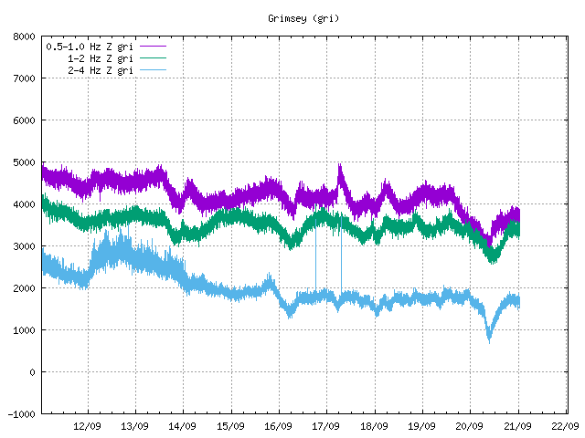
Some magma movement involved?
Actually, it seems to have started in the south part spreading towards north..
Note that they are not manually checked yet. Quite often these swarms of large quakes on the Kolbeinsey ridge give ghost quakes closer to Iceland in the automatic system. Usually they disappear or move north once manually checked.
Another star north of Kolbeinsey and yes, most of the quakes in this swarm are not manually verified yet. Few stations up in the north may give less accurate positioning..
There are quite a few stations in the north, but the problem is that the triangulation becomes ill conditioned when they are all in roughly the same direction from the action. Moving in the north south direction does not significantly change the relative time of arrival between stations.
The problem is similar to planar waves arriving at an array antenna – the direction is easy to estimate, but the distance is difficult (unless you transmitted the signal yourself and listen to the echo, like you do in radar applications).
Had Jan Mayen been closer we would probably get better accuracy.
Note that most of the quakes close to Iceland are now relocated or removed.
Many of them have been reviewed now. Impressive swarm. 15 stars sofar.
Credits IMO.
Thursday
28.02.2019 10:40:13 67.638 -17.917 4.7 km 2.7 90.01 63.5 km NNE of Kolbeinsey
Thursday
28.02.2019 08:18:47 68.121 -18.347 0.1 km 2.4 99.0 109.0 km N of Kolbeinsey
Thursday
28.02.2019 08:06:38 68.240 -18.335 10.0 km 2.3 99.0 122.2 km N of Kolbeinsey
Thursday
28.02.2019 07:47:09 68.065 -18.218 10.0 km 2.7 99.0 103.8 km N of Kolbeinsey
Thursday
28.02.2019 07:47:08 68.089 -18.272 4.8 km 2.6 47.0 106.0 km N of Kolbeinsey
Thursday
28.02.2019 07:43:06 68.234 -18.403 10.0 km 4.3 99.0 121.2 km N of Kolbeinsey
Thursday
28.02.2019 07:37:21 68.198 -18.280 9.8 km 4.1 99.0 117.8 km N of Kolbeinsey
Thursday
28.02.2019 05:52:46 67.243 -17.537 5.3 km 2.1 44.86 50.3 km ENE of Kolbeinsey
Thursday
28.02.2019 02:36:08 68.286 -18.267 10.0 km 3.1 99.0 127.6 km N of Kolbeinsey
Thursday
28.02.2019 02:35:10 67.969 -18.257 10.0 km 2.4 99.0 93.0 km N of Kolbeinsey
Thursday
28.02.2019 02:19:35 68.419 -18.101 10.0 km 2.2 99.0 143.3 km N of Kolbeinsey
Thursday
28.02.2019 02:14:37 67.178 -17.752 25.1 km 2.7 90.02 40.2 km E of Kolbeinsey
Thursday
28.02.2019 02:14:23 68.080 -18.149 15.2 km 3.4 99.0 106.0 km NNE of Kolbeinsey
Thursday
28.02.2019 02:14:21 68.169 -18.139 10.3 km 3.4 99.0 115.7 km N of Kolbeinsey
Thursday
28.02.2019 01:42:04 68.059 -18.237 10.0 km 3.6 99.0 103.0 km N of Kolbeinsey
Thursday
28.02.2019 01:42:01 68.200 -18.331 10.0 km 3.6 99.0 117.8 km N of Kolbeinsey
Thursday
28.02.2019 01:06:30 68.227 -18.313 10.0 km 3.0 99.0 120.9 km N of Kolbeinsey
Thursday
28.02.2019 01:05:20 68.189 -18.186 13.5 km 3.3 99.0 117.6 km N of Kolbeinsey
Thursday
28.02.2019 00:59:49 68.219 -18.193 10.0 km 2.5 99.0 120.8 km N of Kolbeinsey
Thursday
28.02.2019 00:50:58 68.119 -18.224 10.0 km 3.1 99.0 109.6 km N of Kolbeinsey
Thursday
28.02.2019 00:27:39 68.314 -18.325 10.0 km 3.5 99.0 130.4 km N of Kolbeinsey
Thursday
28.02.2019 00:25:47 68.003 -18.375 0.1 km 3.2 99.0 95.8 km N of Kolbeinsey
Thursday
28.02.2019 00:17:17 68.334 -18.335 12.0 km 3.4 99.0 132.5 km N of Kolbeinsey
Thursday
28.02.2019 00:05:03 68.366 -18.374 6.3 km 3.2 99.0 136.0 km N of Kolbeinsey
Thursday
28.02.2019 00:04:49 68.206 -18.132 10.0 km 2.5 99.0 119.8 km N of Kolbeinsey
Thursday
28.02.2019 00:00:37 68.190 -18.012 10.0 km 2.5 99.0 119.2 km NNE of Kolbeinsey
Wednesday
27.02.2019 23:54:21 67.803 -18.252 10.0 km 3.4 99.0 75.1 km NNE of Kolbeinsey
Wednesday
27.02.2019 23:52:34 67.337 -17.904 17.2 km 2.8 90.01 39.4 km ENE of Kolbeinsey
Wednesday
27.02.2019 23:29:43 67.543 -18.103 16.5 km 2.7 90.01 50.4 km NNE of Kolbeinsey
Wednesday
27.02.2019 22:45:16 67.879 -18.019 1.1 km 2.6 45.38 85.9 km NNE of Kolbeinsey
Now when most quakes of the swarm have been verified, more of them are located more northower as predicted by Tomas. However, still an impressive stretch of almost 300km. Would be interesting to see a time plot if the impression that it started south and propagated to the crescendo in the north holds true.
Well, the first >M3 was also the northernmost quake of the entire swarm. A few hours before that there were some quakes >M2 at lower latitudes, but I wouldn’t call it a progression.
Interesting article.
https://eos.org/features/the-unsolved-mystery-of-the-earth-blobs
Very interesting! Thanks!!
Sorry for the intrusion, but I’m desperately trying to get to bed. This is in reference to a back channel discussion.
https://www.thenews.com.pk/latest/437817-meet-pilot-hassan-siddiqui-who-shot-down-indian-jets-violating-pakistan-airspace
NOT VOLCANO RELATED AS FAR AS I KNOW… Again, sorry.
(However, I did barrage my insurance agent with statistical data about volcanoes today… he was most distressed. 😀 )
Hi long time gone due to family issues now resolved . I ne Oregon since Feb 4th weh ave had 60Cm of snow and still have 50Cm on the ground. Temps are 10-12 C below normal.
More snow on the way. Good year to get a new snowblower.
Best to everyone..
Parts of the US seem to have been cold and stormy this winter. The heat in western Europe is related to this: a southern jet stream over the US tends to meander into a northern one here. It can happen with or without global warming: the evidence for warming comes from global averages, not local events (also called ‘weather’). But warmer seas and air do give more moisture and therefore a risk of more rain/snow.
Just got back from blowing more snow.
Weather alright-we’ll have amazing birwatching this spring, btw..
Why not gather some neighbours and call it a race? 😉
https://www.dailymotion.com/video/x72u9lf
Just a picture I drew based on my idea of what kilauea might look like at its peak size, some 150,000 years from now. Though it is not necessarily the most likely option, naturally, I went with the most impressive option. That being the scenario where kilauea (KI) rapidly grows in the near future and ultimately becomes a 7 km tall behemoth that erupts on the scale of 2018 every few years or so, and is capable of erupting at rates comparable to those observed during large fissure eruptions in Iceland. That is exactly what it is doing in the picture, that eruption is in fact occurring a full km below the summit, and the lower vent 2 km lower again. Eruptions of this scale, upwards of 10 km3, are pretty rare, maybe once every few centuries, and eruptions in the 0.1-1 km3 range are much more common, but when these massive eruptions happen the whole world knows about it…
Next to kilauea is loihi (L), which is rather flat but already quite wide, it erupts often but not with high volume. Behind kilauea is mauna loa (ML), it has not exactly aged well and 2/3 of its southwest rift collapsed in a landslide (alika 3, if you will) and has left it with a 2.5 km tall sea cliff on that side. Unlike the first two slides, this one will never fill, eruptions on mauna loa are few and far between now, often hundreds of years apart, and never very big or long lasting, a far cry from its glory days. The summit has not subsided significantly from today however, but closer resembles the summit of todays mauna kea, with many cinder cones.
Mauna kea, hualalai and the remnants of kohala are all behind kilauea, hualalai is still active, with minor eruptions every 1000 years or so, but mauna kea is basically dead, and kohala barely sticks its head above the waves.
This picture is in the height of summer, and the earth is not yet in a deep ice age, but at 7 km tall the summit of kilauea is permanently glaciated and the whole upper 2/3 of the volcano is snowed over in the winter, down to just above the 2 km altitude line. Naturally this results in some rather explosive summit eruptions, though the one portrayed is not one of them. This great height allows even moderate eruptions to have stratospheric impact, large eruptions can impact the global climate.
That is fun to see. The trade winds should cause quite a lot of rain on the eastern slope. 7 km is far above the inversion layer in Hawai’i, so much of the mountain would peak above it, but you would expect a halo of ever-lasting clouds surrounding the mountain on the east. Not much snow on top, I expect, as the air is very dry up there. The glacier will be lower. Expect a battle between eruption and erosion on the eastern side, and a risk of large landslides on the southern side.
Yes the picture isnt perfect, if i had something better than paint I would have tried to do some more details. I didnt do clouds for this exact reason.
The point of view is from slightly southeast of the island.
*Whistles in awe* 7 km?! That’s just under 23,000 feet – right up there with some Andean volcanoes! Frankly, I doubt Kilauea will get that much taller than Mauna Loa’s present elevation in the future as its maximum height. Maybe 15,000-16,000 (4572-4877 m for the metric-minded) if the lava output gets high enough with a strengthening Hawaiian hot spot plume..
There’s something about Kauai – it is home to what’s called the Olokele Member. This is a stratigraphic layer consisting of horizontally laid mostly basaltic lavas. It has been interpreted by scientists as the infill of what was a disproportionately huge caldera in relation to the size of the volcano itself. Kind of like those volcanoes in the Galapagos on steroids. I don’t know if this is the case anymore. But if that was indeed a caldera about 5-6 million years ago when Kauai was right over the Hawaiian hot spot plume, then Kauai and its caldera must’ve been an impressive sight. Imagine! A truly massive shield towering at least 15,000 feet/4900 metres high and topped by an enormous 15 x 10 km wide caldera! Snow could have capped Kauai’s summit most of the year – or maybe only part. Remember that this was during the very early Pliocene epoch, when the planet’s climate was warmer than today overall, although Antarctica was already well covered in ice and Greenland was just starting to grow an ice cap.
Why did I just mention all this above? Well, look at what could happen to Kilauea in the future if it gets truly big as a shield. It’s possible that Mauna Loa could have had an even bigger caldera than what it has today (Moku’aweoweo Caldera) in the past.
For some reason your comments end up in the dungeon and have to wait for release. The cookie jar is in the far left corner – admin
Many of the older hawaiian volcanoes must have been an impressive sight indeed, like how it would be to be looking at the huge scar of the Wailau landslide of East Molokai volcano, a cliff extending for 50 km, rising probably up to 2 or 3 km above the ocean and how it would have been to see lava flows start cascading down into the water. My opinion is that Haleakala is the biggest volcano formed by the Hawaii hotspot in at least the last 10 my. Its absolutely inmense main shield is now completely submerged underwater, the 3 km tall subaerial edifice is made up of materials of the transitional and post-shield stages. At about ~1.3 my ago Haleakala must have reached its maximum size, at that time it was part of Maui Nui island, it grew back to back with nearby Kahoolawe volcano, if I had to guess I would say Haleakala reached a height of about ~5800 m. Together with the summits of Kahoolawe, the stratovolcanish like West Maui and the largely subsided by then East Molokai they formed an arc of mountains shielding the southwest side of the island from the trade winds. This would have created an island of strong climate contrasts between the dry southwest the wet northwest and the tundra-like high summits.
In the more recent volcanoes which have exposed calderas (Koolau, East Molokai, Lanai, Kahoolawe, Mauna Loa, Kilauea and Loihi) the size of them is much smaller than the Olokele caldera, they are tipically about 5 km across.
Yes it is because the rifts of haleakala and kilauea are basically the same length that I theorised kilauea could get so big. Haleakala and kilauea both have main rift zones oriented in basically the same direction, and are on the east side if their respective islands. All the other volcanoes with really long rifts are all uniformly huge, while the volcanoes with shorter rifts are rather more random in how big they get in the end (mauna loa is huge, hualalai is not, but their rifts are similar lengths).
What you cant see on that picture is kilaueas massive coastal plain, 20 km wide below 2 km altitude on the south flank, just like today it still has the large system of fault blocks and palis, rising from the flat plain to nearly a km high in some cases. The plain extends even further in the north, lava erupted near kilaueas summit has actually buried the hilo area and extends all the way to the east coast of mauna kea.
The distance between the northernmost lava from kilauea next to mauna kea, and the southernmost on both sides of loihi, is about 150 km. In hindsight it might be a stretch to say all this will happen in 150,000 years, mauna loa is half a million years old which is 100,000 years older than kilauea will be in this picture, and I dont think mauna loa was as big as it is now 100,000 years ago.
Haleakala had however 3 proper rifts during the shield, this configuration was probably stable because Haleakala had two unbutressed flanks, the ERZ was dominant (completely unbutressed until Kohala formed) but the other two did not impose each other. The NW rift zone is a strong gravity anomaly similar or even more marked than the SW rift. It is clear that the NW rift has almost faded during the postshield but some recent vents are still aligned along it.
But I agree in that Kilauea seems right now to be another of those huge ERZ dominated volcanoes (Kohala, Haleakala and East Maui) underway.
Because of where it where it is located in the Eastern Pacific, Kilauea already has more than enough height for moderate eruptions to interact with the UT/LS/jet stream.
Thus, at the rate required to build Kilauea into this hypothesized monster in only 150,00 years, it would also have already started the next ice age just a few decades into that 150,000 year plan.
Do one as best as you can.. you are very good drawing…
And I cannot even draw a stickman or a simply pahoehoe toe
I wants to see a highly detailed version and more views on future Kilauea.
The ocean entry from that potential to become 18km3 sized flow will be an impressive sight
A fast moving Aa sheet 12 km wide crashes into the ocean forming a steam plume 8 km high.
The eruption forms raging lava rivers that flows 80 km an hour and 3000 cubic meters a second.
If humans are still around its world news and happens once every 200 years
Its way harder to draw detail with microsoft paint…
As for the eruptions I would imagine them being more like mauna loas big eruptions now except probably with higher fountains, not like laki. Skaftar fires was not a hawaiian eruption it was really its own type of eruption that doesnt easily fit anywhere on the normal spectrum of volcanism (which also wrongly bases SiO2 content as the main factor when it should be eruption rate and volatile content). However despite the massive amount of lava erupted I would place the skaftar fires eruptions as closer to plinian than hawaiian. Even in its peak I dont think kilauea could erupt this vigorously, unless a massive deep intrusion happened that bypassed the summit system. The 20 km3 scale flows I was thinking are basically like the eruption last year except longer lasting and with more fissures, the eruption rate will obviously be higher owing to the near 7 km altitude difference but not to the extreme measures that occurred during the skaftar fires eruptions, those eruptions were caused by near instant total decompression of a large section of the rift that exposed a lot of magma, and the magma likely already existed under the rift rather than forceful intrusion afterwards (others may disagree with that interpretation but there is something fundamentally different between the skaftar fires and holuhraun and I dont think it was a 400 meter altitude difference at the eruption location).
It isnt visible here but the distal end of the east rift is pretty flat, not much different than now, and it is here that I imagine most big eruptions like that would happen. The eruption in the picture is the initial opening stage, with vents rapidly propagating downrift.