
The long-awaited eruption has started, and has been confirmed by IMO. Just after 9pm the first light became visible on the cameras. At 21:40 official confirmation came. IMO has decided that the eruption began at 20:45. The location is not entirely clear yet, but the most recent earthquakes would indicate it is pretty much where expected, just south of the peak of Fagradalsfjall. There was no seismic signal, but in hindsight the near-surface M3.1 this afternoon was the straw that broke the camel’s back.
This solves the question whether this event was tectonic or magmatic. This is the first eruption in Reykjanes since about 1200 AD, and is likely the start of a longer period (centuries) of new activity on the peninsula. The current eruption may or may not last long. We do not know very much about how volcanics on the peninsula works. But eruptions here are likely to produce of order 0.1 km3 of lava, enough perhaps to reach the ocean and cause inconvenience, but not do major damage.
The fact that there were no earthquakes announcing the eruption suggests that the magma was already very close to the surface. A filled conduit is silent. The earthquakes come from breaking the conduit open, and tremor from filling it up. There was almost no tremor either (a15-min low frequency burst before the eruption was reported, only noted in hindsight), so magma may already have been ready since a few days. It was just waiting for the weekend.
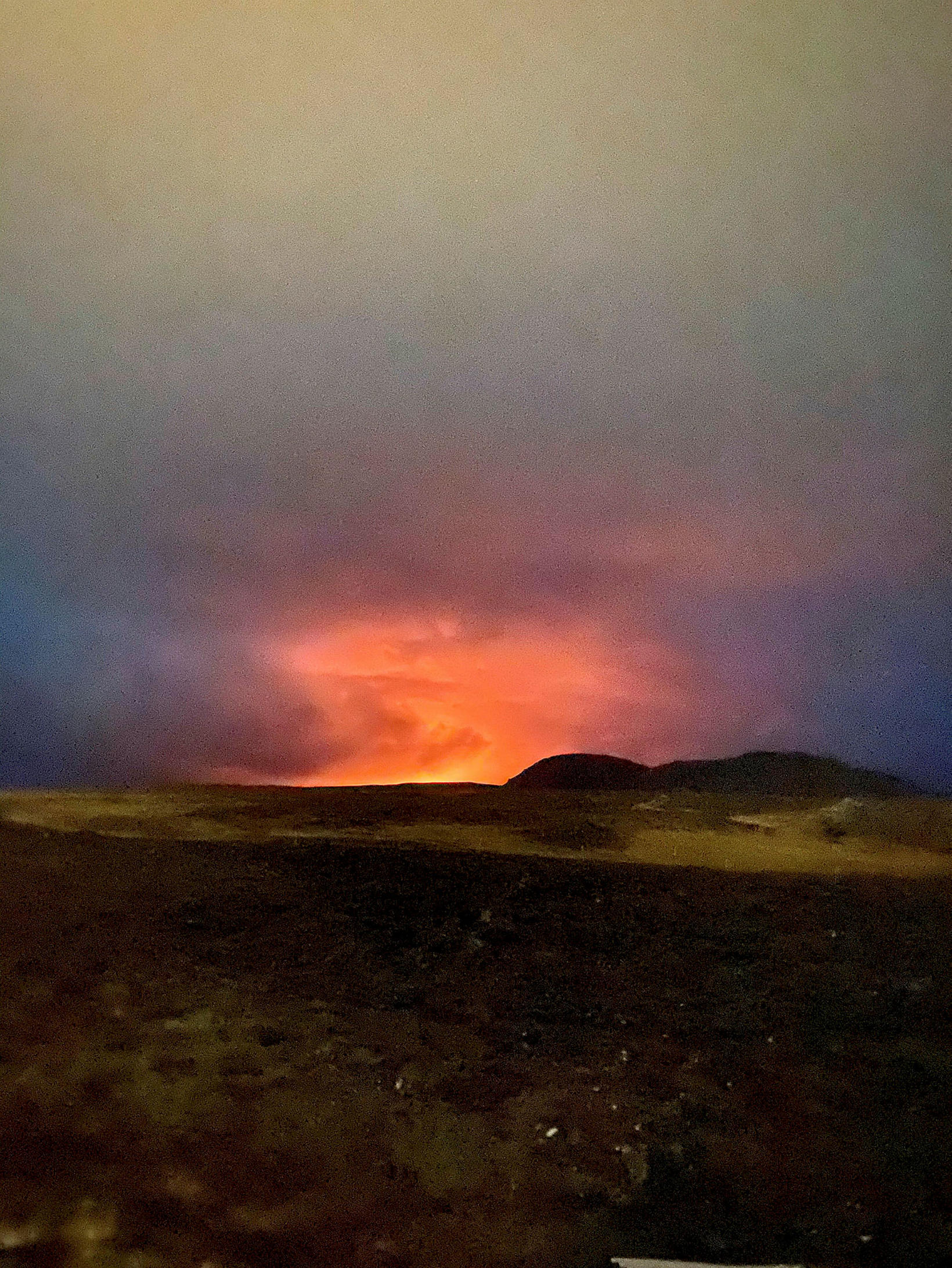
The red glow suggests fountaining but we are waiting for further reports. We will add news here as it appears. We actually rely mostly on you!

And as a final point, when we announced the 1-year postponement of the eruption last year (April 1), we had no idea how close we were to reality.
A direct view of the rift is from the following webcam. It was at first pointing in the wrong direction but not has a great view of the eruption
https://www.ruv.is/frett/2021/03/20/beint-vefstreymi-fra-borgarfjalli-ad-eldstodvunum
Another suitable webcam is https://www.ipcamlive.com/60401b8d3413c
Also see
https://www.visir.is/g/20212080986d/oroasvaedid-i-beinni-utsendingu
Road cameras are at http://www.road.is/travel-info/web-cams/south-west-iceland

Image provided to us by Judge Matthews and reproduced by permission
The eruption is confirmed to be in the Geldingaladir. A 500-meter fissure is reported with 4-6 small fountains. In this location the lava will be confined and does not appear to endanger infrastructure. It is a perfect small eruption. The valley is enclosed, and if the the eruption lasts long enough to fill up the valley (less likely) it would flow into another valley and go north away from any people. (It seems more likely that the eruption will stop well before but may erupt in a new location.) For a detailed map, we recommend http://kortasja.lmi.is/mapview/?application=kortasja


www.facebook.com/Vedurstofan/photos/a.431284043605831/3930732966994237/
Keep posted! And keep posting.
https://www.ruv.is/frett/2021/03/20/beint-vefstreymi-fra-eldstodvunum


Finally , by the looks of the glow it seems quite big…
I also wonder with hindsight, whether the impending eruption had any bearing on the demise of the Borgarfjall cam.
I doubt it, but the earthquakes may have.
Yeeeessssss yeeeeeeeeesssssssssssss PREEECCIIIOUUSSSSS
Preeeeeeeeecccuuiiiiouuuusssssssssss!!!!!!!!!!!!!! Yeeeeeeeääääääää
preeeeeeeeeciouuuuuusssssssssssssss!!!😍🌋🌋🌋( coughing Gollum! Gollum!!! )
Erupt erupt erupt!! Smeeeagol is freeeeeeeeee
https://twitter.com/VTLAB_Joel/status/1373036978065801221
Häääää heeee yeesssssssss
Yesssssss preeeeecuioussssss!
Shhhhhhh 😍😍😍🌋🌋🌋🌋🌋🌋
Nice touch to this Albert 😀
From Grindavík. Credit: Sólný Pálsdóttir
Nice photograph indeed!
That is a gorgeous photograph.
https://www.ruv.is/frett/2021/03/19/volcanic-eruption-has-started
Not that it is important, but we lurkers had it at 21:10 (the first screenshot above is even from 21:07**). I know this is childish.
How exciting this is!
** and 11 seconds
Correct. 21:40 was, I think, when it was confirmed by IMO. It started half an hour earlier
When shortly after 21:07 it really bubbled up I almost wetted my pants.
I was ready to tell you it was something else, but when I looked at teh actual cam, it didn’t look like anything else.
Likewise.
It was just too bright to be anything else. Too big.
If you are on reddit, then a megathread has been pinned in the Iceland subreddit, pics and whatnot may pop up there. https://www.reddit.com/r/Iceland/comments/m8selz/eldgoseruption_ofur%C3%BEr%C3%A1%C3%B0urmegathread/
Funny to see all the cars stand on the side of Reykjanesbraut with their warning lights on and watching the eruption. This is Iceland.
https://www.ipcamlive.com/60401b8d3413c
Poor Etna 🙁
Make that 15 paroxysms.
The eruptions at Reykjanes are though important, this one might only last a few hours but its the first in that area in the Holocene, and likely the first of quite a few along this dike over the coming year or two. It also has not yet set off the section of the fault at Brennisteinsfjoll, and it could be primed to go, a repeat of this past few weeks but with a bigger quake.
I found a walking map, not too suggest that anyone should walk there right now, except for professionals. https ://issuu.com/traveltoreykjanes/docs/bm_go_ngulei_akort-2018_11ju_ni__final
Helicopter in the air (or drone). Light is less intense now, but that might be due to the missing lower ceiling at the moment.
It’s brighter now on the Keilir cam than it was.
I’ve been trying to line things up and I put the eruption in the close vicinity of Geldingadalir, which was the location of a rapid swarm a couple of days ago.
That sounds about right, judged by the MILA cam angle. Here is a nice image of the landscape, maybe alread posted before:
https://www.iceland360vr.com/panorama/fagradalsfjall/
Confirmed by Bjarki’s link below.
It’s impressive here…
https://www.ipcamlive.com/60401b8d3413c
The eruption has happened at a place called Geldingadalur in Fagradalsfjall, so the eruption will likely be named Geldingadalsgos according to Almannavarnir https://www.ruv.is/frett/2021/03/18/helstu-tidindi-eldgos-hafid-i-fagradalsfjalli
Ah, so I was right in my calculations.
They say many people have gone over to look at it so I hope we see some video soon 🙂
Erupted it looms like on the side facing the Keilir webcam, but its too far away to see detail through the glow on the IR cam. The lava flows are going to flow north from here so should be nice and slow and safe to look at, not fast and dangerous like if it erupted at the southern end near the ocean 🙂
I do though have a feeling this fissure will stop erupting by the time anyone can look at it… usually the first fissure is very small and bigger ones erupt later.
23.07 The first image of the eruption. Taken from the Coast Guard helicopter. The southern end of the tongue is about 2.6 km from Suðurstrandarvegur. According to initial information, the fissure is about 200 m long.
https://www.ruv.is/frett/2021/03/18/helstu-tidindi-eldgos-hafid-i-fagradalsfjalli
‘Considered a small soda but dangerous’ 🙂
I’ve always loved how our language uses the same word for a soft drink/soda and an 🌋
https://www.facebook.com/Vedurstofan/photos/a.431284043605831/3930732966994237/?type=3
More about the eruption
According to information from the Meteorological Office, a narrow tongue flows into SSV and other tongues to the west, according to initial information. There are flames that can be seen in fissures. “It is a small eruption that is very special,” says a geophysicist in the evening news on RÚV. This is similar to the eruption at Fimmvörðuháls, where the Meteorological Office did not hear about the eruption until reports of lightning began to arrive.
I am being misled by MapCarta on this location.. does anyone have an accurate geodetic location? latitude, longitude, height fix?
Pingback: Bulletin from Reykjanes – Zoopraxiscope
Very bright now…
https://www.livefromiceland.is/webcams/keilir/
And a lot brighter on here now (and also in colour now)
https://vegasja.vegagerdin.is/eng/?xmin=315811&ymax=438600&xmax=419011&ymin=365280
Due to potential SO2 gas emissions from the #volcanic #eruption in #Fagradalsfjall people living in Thorlakshofn (Þorlákshöfn) are asked to stay indoors, close windows, and increase their heating temperature to reduce the ability of gas to get inside. #icerupt
10:53 PM · Mar 19, 2021
Oxygen levels are monitored I guess 🤔
Krísuvík Volcano Volcanic Ash Advisory: EURPTION CONFIRMED OBS VA DTG: 19/2143Z
Fri, 19 Mar 2021, 22:15
22:15 PM | BY: VN
Volcanic Ash Advisory Center London (VAAC) issued the following report:
FVXX01 at 22:02 UTC, 19/03/21 from EGRR
VA ADVISORY
DTG: 20210319/2159Z
VAAC: LONDON
VOLCANO: KRISUVIK 371030
PSN: N6355 W02204
AREA: ICELAND
SUMMIT ELEV: 360M
ADVISORY NR: 2021/001
INFO SOURCE: ICELAND MET OFFICE
AVIATION COLOUR CODE: RED
ERUPTION DETAILS: EURPTION CONFIRMED
OBS VA DTG: 19/2143Z
OBS VA CLD: NOT AVBL MOV SW 70KT
FCST VA CLD +6 HR: 20/0343Z NOT AVBL
FCST VA CLD +12 HR: 20/0943Z NOT AVBL
FCST VA CLD +18 HR: 20/1543Z NOT AVBL
RMK: MAX HEIGHT OF PLUME 5KM
MOST LIKELY 1-5 KM
NXT ADVISORY: NO LATER THAN 20210320/2200Z
=
http://www.volcanodiscovery.com/krisuvik/news/125024/Krisuvik-Volcano-Volcanic-Ash-Advisory-EURPTION-CONFIRMED-OBS-VA-DTG-192143Z.html
Just as I was going to bed! It took it’s time but we have eruption. helicopter taking a look. I’d rather watch from here! I feel I should say something like congratulations ,like a birth. But I do hope al people and property are safe.
I think Carl deserves a congratulations. He got this right. So did IMO. It is nice to see how such an exceptional (once in 800 years!) event became so well predicted.
OOOOO Diana! (((((( volcano)))))) wheee… but i have to admit… i’ve eaten all the popcorn… (hangs head) sorry.
A blinking light can at times be seen orbiting around the bright area on this cam https://www.ipcamlive.com/60401b8d3413c . Hopefully we will see some aerial shots soon.
Here you go. Didn’t take long 🙂
https://www.facebook.com/Vedurstofan/photos/a.431284043605831/3930732966994237/
There is also a plane flying around the volcano at a lower altitude, a Beechcraft. I believe that might be the light we see.
https://twitter.com/Vedurstofan/status/1373048364623888390
First pic from helicopter
Nice! Helicopter was just visible on MILA’s Keilir cam.
Lava streams!!
Short video taken from the helicopter can be seen here https://www.ruv.is/frett/2021/03/18/helstu-tidindi-eldgos-hafid-i-fagradalsfjalli
There are now two videos from the helicopter
https://www.ruv.is/frett/2021/03/18/helstu-tidindi-eldgos-hafid-i-fagradalsfjalli
From the later one, it looks like 3-4 lava fountains.
Maybe up to 6.
A direct link to the seoncd, better video.
https://www.facebook.com/425701797497389/videos/1591514964571078
Very cool! Looks like it’s pretty small, maybe less than half a km or so in length(?). It might be a small one at first, then the next episode could be larger like what happened at Holuhraun. Or it grow even bigger all at once. It might stop before even the sun rises there. We don’t know, because as we all know, volcanoes are still highly unpredictable beasts, no matter how advanced we are in terms of predicting eruptions.
According to IMO, it’s 200m.
New update:
The eruption fissure probably 500 meters
According to information from the Meteorological Office, the eruption fissure is probably about 500 meters. It is considered to be small, it is in Fagradalsfjall in a valley called Geldingadalur. Residents of Þorlákshöfn have been asked to stay indoors and close windows due to the risk of gas pollution. The eruption is not considered a threat to settlements or roads, according to the latest information
Preeeeeeeeecccciiuuusssssssssssssssss
🇮🇸🇮🇸🇮🇸🇮🇸🇮🇸🇮🇸🇮🇸🇮🇸🇮🇸🌋
Helicopter flying in the distance, observing the activity. Congrats Iceland, with a brand new baby eruption!
Newest estimate is that the fissure is around 500m long. There is lava flowing both to the South and West – but due to the location lava is not expected to cause any issues.
We have sheep from RUV giggle translate
In Geldingadalur, some Ísólfur at Skála will have let himself be drenched. “For there he would rest, for his sheep are doing him good.” And now some eruption has begun in this valley and the eruption will probably bear the name of the valley, Geldingadalsgos.
Giggle translatw says for sheep there are different
noun
sheep: kind
sheep: sauðkind
sheep: sauður
Looks like the last one is ours. This is the vally of the sheep.
Perhaps one of our Icelandic commenters can confirm (or otherwise)? Giggle is not actually the final authority on language.. It would be something to have the eruption named after a VC tradition (flying sheep)
For anyone curious about the meaning of name of the valley 😉 https://en.wiktionary.org/wiki/gelding
Guess it is not a ram then.
So it’s the same as in English. It crossed my mind the other day, but didn’t really think it was gelding.
It’s also used for eunuchs but I’m pretty sure the name is referring to the livestock variety 😂
I thought it interesting that there were three different words for sheep. Looks like a bible quote in the middle of the ruv caption.
Geldingur = some that has been castrated (usually this actually refers to farm animals).
Geldingadalur = valley of the castrated or valley of castration.
Your welcome 😉
Ewesome!! Isn’t it?
And congrats to Carl. Spot on. Again.
Geldingur = Gelding (neutered horse)
So it’s the valley of the geldings, Geldingadalur
Thanks! That is almost sheep..
In english a castrated ram is called a wether.
So I guess wethervalley.
https://www.visir.is/g/20212080986d/oroasvaedid-i-beinni-utsendingu
Heat cam back on
The news has reached Norway and Denmark, both DR and NRK have reported it.
BBC World also has something.
Yep, you beat me to it.
https://www.bbc.co.uk/news/world-europe-56465393
I just looked at the drum plots and thought: no way. Came here and saw the news! That’s a result! It will be very interesting to see how long activity may persist in the area, now.
Please can someone have a word with Iceland and tell it that it’s very inconvenient erupting at night.
On the other hand, it probably made it more visible. It will be interesting to see daytime shots though, as I can’t place the exact spot for the lava to flow west and south.
True. This webcam has a lovely glow: https://www.youtube.com/watch?v=8pnkJ-Rb7uE
It seems like effusive eruptions always happen at night 🙂 Holuhraun began at night, and HVO have said a majority of Kilaueas eruptions have begun at night.
I guess its the glow, probably not much would be obvious in the day even now after the eruption has been going for an hour, if it was in the day maybe no one would have even seen it yet with how cloudy it usually is there.
It’s about midnight in Reykjavik, so sunrise is about 7 1/2 hours away. Still way too early.
I hope they set up a camera with a more direct view soon
People living in Thorlakshofn, Selfoss, Hveragerdi, and Vestmannaeyjar and surrounding areas are asked to close windows and increase the indoor heat to create negative pressure that keeps SO2 gas from eruption out.
For aviation nerds (like myself) the aircraft you can see flying past every so often is a Beech 200 Super King Air of Isavia, a charter operator. The helicopter seen earlier was a Supa Puma of the Icelandic Coast Guard. Data from Flightradar 24.
The temporary closure at
@kefairport
has been lifted and the airport is now fully operational. A flight from
@wizzair
is expected to land around 00:25 GMT and passengers can expect to see the eruption as they approach the airport. #bonus
I can feel the seething jealousy
Has anyone on that plane taken a video and uploaded it yet 🙂
they move the camera?!?
There’s a person like thing live on the IP cam. Looks like an alien. lol. 🙂
https://www.ipcamlive.com/60401b8d3413c?fbclid=IwAR2tgT5jLKQg9wzXwM67_awVMnYruEOO9rNzuiVrFzzhhyYM6jEPZ1bCL6w
(I videoed it from my screen and posted it on the VC Facebook group).
I just booked a flight to Iceland.
I mean I am joking. I can’t. No flights allowed out of Scotland. Maybe I will in a month or two.
Who would say that the next eruption would have been at a volcano that never erupted in the a Holocene. Fragadalsfjoll is usually not even listed as a volcanic system. But clearly it is.
This is historical. The first eruption in the region in 800 years. What an event. It will being changes to Iceland as it marks the beginning of a cycle of eruptions in the Reykjanes peninsula.
And it was totally predicted. By both the scientists and by many of us at Volcano Cafe.
I am amazed to see further evidence of my hypothesis of large rifting events at Vatnajokul being linked to the start of eruptive cycles at Reykjanes.
Do yourself a favour and visit this webcam
http://www.road.is/travel-info/web-cams/south-west-iceland
The traffic webcam at Festerfjall, shows the eruption is amazing real time flavour.
How long is it since, Fagrad itself went up? 12k years?
Early Holocene, last eruption was around 10,000 years ago
http://jardfraedikort.is/
I think places like GVP though consider Fagradalsfjall a part of Krysuvik, so GVP will probably update Krysuvik to having its latest eruption in 2021, but I dont know if that will still hold up long term and they could add a proper page for Fagradalsfjall in the future.
Now my predictions.
1) This eruption might last 6-9 months or it might actually last several years.
2) It might be a shield. The region has seen shield volcano eruptions. It might be in the range 0.1-2km3.
3) But it will be slow and long lasting probably. Possibly with breaks between different eruptive episodes. Which can start in other locations or in the same location (I’d this becomes a shield)
4) And we might see some fantastic lava fall if the flows jump the typical tall cliffs of the southern coast of Reykjanes.
5) This post by Albert will probably become the one with the longest chain of comments in the blog history.
No the longest chain will be when Grimsvotn erupts, because I also think this eruption will last a long time in some way and Grimsvotn will likely erupt while it is ongoing.
The comment chain with the most individual words though will be when Mauna Loa wakes up, Hawaiian eruptions bring out the long discussions while Icelandic eruptions bring in the lurkers who might not say much but are numerous and keen to contribute.
And then there is Jesper who I think now is going to immediately move to Iceland 🙂
The Coast Guard helicopter is on its’ way again out of Reykjavik
Confirmed time has come for the eruption – it started at 20:45
This is an announcement from the Icelandic Meteorological Office
The eruption began at Fagradalsfjall in Geldingadalur, at about 20:45 tonight. The eruption is considered visible and the eruption fissure about 500-700 m long. The lava is less than 1 km2 in size. There is little eruption activity in the area.
The Coast Guard and scientists have flown over the eruption sites.
The staff of the Meteorological Office and rescue crews have gone to the area for gas measurements
Ground view up close?
20:45 as in Icelandic time/UK time? Both these countries share the same time zone.
Yep, the times match at the moment (they don’t all year round). Quinauberon first posted, not long after 21.00.
The lava in the night is sooo bright
Soooo colourful … ssssoooo beautyfulll …….
its ouuuuuurrr..
Prreecccuuuuiiiouuusssssssssssssss!!
( cough! )
A colourful translation:
Says the eruption is a terrible fart
Magnús Tumi Guðmundsson, professor of geology, spoke to Brodda Broddason tonight from the Isavía plane. He saw the eruption very well, he says the lava flows down into Geldingadalur and the lava has flowed approx. kilometers in each direction. Magnús says the eruption is a “scary bastard”. He says lava eruptions are always majestic, but this is not a big eruption, fortunately, and Geldingadalur is one of the best places to erupt. It had been running for three hours but had made little progress. Broddi says goodbye to Magnús Tuma with the words that it is up to Magnús Tuma to understand that the eruption is “rather insignificant.”
“rather insignificant.” famous last words, just give it time, after all it woke up from a long time slumber
Low flying helicopter showing up nicely from left to right on thermal cam. I guess checking emissions which can clearly be seen to the far left on the thermal cam well away from the “red glow” to the right. Are there any bodies of water in that valley? Streams or ponds? Going to fly over myself on Google Earth. Then a happy landing in my bed. Keep safe everyone and sleep well… if you can!
I can’t see any water. This shows the valley better than Google Earth. I think the eruption is on the eastern slope of the valley. I use it to orientate on Google Earth.
http://kortasja.lmi.is/mapview/?application=kortasja
Thanks Avalon that helps pinpoint the sheepy valley! 🙂
😍😍😍🇮🇸🇮🇸🇮🇸🌋🌋🌋