
It is hard to remember what Iceland was like three years ago. At that time, most (or all) eruptions were in the eastern volcanic zone, from Katla (and friends) to Krafla. (Ok, one can argue about the precise borders. Grimsvotn was about to erupt. The Thorbjorn swarm had happened and an eruption at Reykjanes was seen as possible, but the peninsula had been quiet for 800 years. This was when we postponed the eruption to 2021 due to covid (cue: April 1). Iceland followed our lead and indeed in early 2021, after an impressive series of earthquakes on the Reykjanes fault, an eruption followed in the most unlikely location: Geldingadalir, a remote valley within Fagradagsfjall, where no eruptions had occurred for perhaps 30,000 years. Who would have guessed? Since that time, there have been three eruptions in three years. And we are still waiting for Grimsvotn.
The first Fagradalsfjall eruption was perfect tourism. It was in a location where no one was endangered, while still easy to reach for the watchers. This being Iceland, webcams were put up in various locations, maintained by the locals and watched around the world. Of course, this being Iceland, the locals use the cameras to display themselves and even slogans were put on view, sometimes to the watcher’s entertainment and sometimes to their annoyance. But when entertainment is provided for free, it is hard to begrudge the occasional advert! The eruption evolved through fissures, effusive cones, tall fountains visible from Reykjavik (lucky things) an finally sputtering. We learned that Icelandic eruptions can be controlled. A wall was build to deflect the lava, and indeed the lava was deflected. The same was attempted at the place where the lava began the threaten the road and farms, and immediately the eruption ended.

The power of Iceland was obvious in many ways. As Reykjanes sputtered into action. Etna was delivering unbelievable fountains, tall enough to keep even Jesper happy (perhaps not Tallis). But it stood no chance. The eyes of the world were drawn north.

It ended after some 6 months. By that time the original valley of the eruption no longer existed, and neither did the deeper valley next door nor the hill were the first lava emerged . Iceland was left with new geography and a new hill which still has a warm conduit, and we were left with happy memories.
A year later came a new eruption, an afterthought of the first. We had kind of expected that the Earth was not finished here and that at some time the magma would break through again. It happened in the northern part of the original eruption. The eruption was much less vigorous, and season II was a pleasant sight but not on par with season I. The lava field expanded a little but that was it.
For the start of Season 2, see
https://drive.google.com/file/d/1PKzvTGMTr_Iln5VijqOosRj_SiyYNQlX/view
But intrusions continued, last winter and in the spring. As before, a dike sprung up and expanded in a NNE-SSW direction. The location of the deeper magma source is not so easy to determine. The first intrusion had been further west. This being a zone with a bit of extension, there is a region some 5 kilometer wide below which magma can collect. From there, dikes can grow. Some are very deep, tens of kilometers. This go north, and can continue for 50 kilometers or more but they never reach the surface. More common are shallower dikes at 5-7 kilometers which do not go very far but quickly move up. The current intrusion was focussed further north than might be expected, with the upward growth southeast of Keilir. But it is not clear where the magma originally came from. The earthquakes and insar showed that the dike extended between Keilir and Litli Hritur, just north of Fagradalfjall.


The eruption started today at the bottom slope of Litli Hrutur, with a 900-meter fissure extending about half the distance to Keilir. As I am writing this, the lava is beginning to flow around the hill but it is not clear to me in which direction! And sadly, the eruption is too close to the cameras for a good view! I am sure that will be fixed. This is Iceland, after all. They will try to move the eruption.

What will happen next? The eruption had a sluggish start, surprising perhaps after the vigorous dike formation. But this was also the case in Season 1, and in any case the volume seems to have increased a lot as the fissure lengthened. This could develop in an event similar to series 1, lasting several months and covering a large area but well away from roads and houses. It could also be a rerun of Season 2, lasting a few weeks. The former seems more likely given the intrusion, but this is not certain.
Viewing will be harder than for Season 1, being further away from the road and requiring a longer walk. But I am sure that the coffee van will be appearing shortly at the parking area, ready for the thirsty tourists. We are in for a treat.

Location of the dike. Initial lava flow shown in blue
Albert, July 2023
And here is a reflection by Randall, taken from the comments
My own personal observations of events leading up to the fissure eruption.
- The website https://vafri.is/quake/#close posting quakes proved invaluable this time for knowing how events were progressing. I watched the screen literally hours and began to discern patterns. Once there was like a surge and small quakes burst out over in the Krisuvik area and you could follow this surge by watching for about 1/2 hour or so. I took this to mean a magma surge. The constant activity to the NE showed that pressure was high.
-
A key comment made by Tomas Andersson about triggered quakes related to the inSar butterfly picture helped me to understand the quakes occurring on the vafri.is/quake website for the past 3 days.
-
The FAF seisometer was a good source of watching the microquakes, and I am sure that at least 3 episodes (barefuly distinguishable) of microtremors occurred. The time from 14:50 pm to 18:00 pm today (2023-July-10) on the seismo shows a slightly thicker trace. This seems to indicate that actually watching microtremors is a very difficult science even today and fissure eruptions are still hard to accurately predict
-
The strong 5.22 quake yesterday had few aftershocks, indicating (my terms) mushy ground or softened up ground by magmatic intrusion. This in hindsight was an indicator of closeness to the actual eruption.
-
There appears to have been a small microquake around 16:38 pm which slightly shook the RUV cameras on Litli-Hrutar, and I take this as the final breakthrough of the fissure. IMO dated the eruption at 16:40 and the RUV north camera showed the first smoke at 16:41:07 pm. It is really hard to catch fissure eruptions as they first begin.
-
The two flights of small birds that I saw around midnight Iceland time were interesting. Birds seem to have a foreknowledge of events, and their flight path was directly away from the region at about right angles to it (giving them the maximum distance via minimal flight time) Before the Hebgen Montana 7.3 quake of Monday August 17, 1959, the water fowl left Hebgen Lake about 2 pm in the afternoon and their absence was noted in the sheriff’s log at West Yellowstone. The quake that evening gave the reason why the waterfowl left. They came back to the lake after the 3rd aftershock on Wednesday Aug 19th or so. My dad took our family to this epicenter about 2 or 3 days later and we saw the lake filling up, and all the damage and trees disappearing into the water and it left an indelible impression upon me as an 8 year old.
-
Scientifically things have improved, we’re in a better knowledable condition that when the 1st eruption started back in 2021.
-
The hot water pouring from the borehole in Avedir (spelling) was definitely a sign of nearness of the eruption, but it was 11 km from Keilir. That is a wide area for a thermal pulse to travel. Do we know much about how much thermal energy is spread when a dike intrudes? More studies of borehole water and temps needs to be done.
-
Several people on Volcano Cafe gave fairly accurate predictions of the location of the fissure eruption, I believe Albert might have been the first to speak up. Chad gave one as did Alice, but there were others and I apologize for not mentioning you.
Finally the excitement leading up to a fissure eruption is almost addictive. It really is fun watching a volcanic event like this occur, especially when it is fissure eruptions which have not occurred for some 800 years.
These are some thoughts as I reflect back through events leading up to the fissure eruption today.
And a response to these: the hot water can easily flow 11 kilometers, so it may well have come from the region around Keilir. The underground rock insulates well but underground water can circulate and transfer heat very effectively when coming close to the magma. Gas emissions can also heat up the region. As to the birds, this was commented on below. It seems unlikely they predict eruptions, and in fact I recall tropic birds flying very close to the eruptions at Kilauea. They may be affected by earthquakes, of course, and perhaps by the SO2 emissions that can precede an eruption – Albert


Current Livestream from Drone – LIVE 10.07.23 Volcano eruption started in Iceland! Drone live stream
Isak Finnbogason – ICELAND FPV
Having more problems with this one. It won’t buffer very far ahead, and it won’t use more than 1/3 of my Internet connection. It seems to be maxing out at around 1Mbps on my 3Mbps ADSL connection, even when I’m not using any other bandwidth here. Wired all the way (no WiFi). Anyone have any clues what would cause that? It looks almost as if YT is capping the speed at their end … unless my ISP has downgraded my connection without my permission, without so much as a notification, and without a corresponding downgrade of the price. (Surely not?)
It is a 60 frames per second video at 720p or above and some older hardware may not be able to display that without stuttering (but still tries instead of dropping back). Maybe try manually dropping to 480p. However if you are on reasonably new device (pc/laptop/tablet/phone) you should be able to get 1080p/60. On some devices including PC you can right click the videeo and select “Stats for nerds” to see bandwidth and dropped frames.
I did back it down to 480p. Even then, it is acting like I have only a fraction of the bandwidth needed (and an even smaller fraction of the bandwidth I have). Is there some YT setting I can tweak to fix this?
It’s definitely a YT/network problem, not my processor or video card. I can watch 1080p videos from local storage on the same machine without issue.
What kind of a device are you on? Can you get “Stats for nerds” with a right click? Depending on hardware/software you may not have full hardware acceleration available when watching youtube in a browser but may have it when watching videos with a dedicated video player (or youtube app). For example my Raspberry Pi 400 can play 4k/60fps videos in kodi or vlc but can’t play higher than 720p/60 or 1080p/30 in a browser. I have no problem in playing the video at 1080p/60 on my main PC so it isn’t the stream itself.
However as you say you could have an ISP problem so it would help if you could see what stats for nerds says about available bandwidth, codec and dropped frames.
Forgot to add it might be worth trying the h264ify extention if playing via a browser. Sometimes youtube selects a high efficiency codec that slightly older hardware struggles to software decode. h264ify available for Chrome/Edge/Firefox etc. forces youtube to use h264 codec which almost all currently in use devices can hardware decode.
https://chrome.google.com/webstore/detail/h264ify/aleakchihdccplidncghkekgioiakgal
I’m pretty sure it’s a network/YT issue, not a codec issue, or it would buffer ahead just fine but stutter during playback of even pre-buffered material.
Eventually I thought to just find a youtube downloader extension and download the damn thing for viewing offline, but amazingly I can’t find one that works! Most of them are obvious scams (try to redirect you to some website somewhere, or they seem to work until you pick “1080p” from the list of offered resolutions and then say “we won’t do 1080p unless you pay up”, or similar BS) but even previously trusted names either just mysteriously aren’t working or (e.g. Video Download Helper) only show a few low resolution options (nothing above 240p?! Even after raising the ridiculously low “show max this many streams” default of 6 to 60?)
I expect there to be something of an arms race between Youtube and downloader extension makers, but there should be some extension that’s ahead at any given random time, and since when does Mozilla allow blatantly fraudulent crap in their extension store with blatant ballot box stuffing of their review scores?
Clearly higher intensity than previous ones at this point, thrown out a lot of rock given its been less than 4 hours. One other interesting thing is it isn’t a nice fissure line like the previous two. Sure there are straight fissures, but they aren’t on the same line, the second one to open is clearly at an angle to the first one. That’s different as in the first eruption even the fissures that opened later were on the same line. I wonder why given it is presumably the same dike?
Yeah, 3 fissures, none of them in a line with each other…
I would imagine that it’s to do with the weaknesses at the surface within the original shield lava sheet, than the underlying dyke.
With the forced perspective on the drone camera, the fissures look reasonably parallel, albeit a bit offset, to me.
There’s certainly a goodly amount of the red stuff flowing south. Past the mountain, it’s fanning out well.
I’m worried about all those people on the moss plain, if there’s a wind shift the gas is not going to be healthy for them.
Isak is talking about some fog/low cloud closing in. He’s based on the ridge opposite the fissure, where the helicopter is landing occasionally.
The fissures will be reasonably parallel over the full length. But at short distances you can easily get small offsets (~100 meter?). It is like tearing paper: it will tear but the different break may not line up perfectly
Estimated location of the fissure. Blue is the lava flow, but note that the lava further up the fissure can go in different directions
Looking at this, bearing in mind the ridge on which the early news folks landed, what we’ve seen on the plain where individuals approached the fissures, and the directions of flow, I wonder at how realistic is the possibility of accessing this site other than by air. I see posts else where describing the locations of traditional hiking trails and parking areas. That may all change literally overnight.
Thank you all for the exellent coverage leading up to season 3. And what a season start it is.
From RUV – news in english – tonight;
Magnús Tumi Guðmundsson, professor of geophysics, said originally that the eruption is small, at least so far. However, after flying over the site with the Coast Guard, he revised his view.
“In short, it’s quite a bit more effervescent than the other two, [at least] in the beginning. It grew significantly in the first hour. The fissure is about 900 meters long, which is much longer than in the other eruptions. It is quite active, and the lava has grown to about one and a half kilometers in total. Roughly speaking, this first eruption appears to be at least ten times larger than the initial eruption and two, three, four times larger than what happened last year. There’s a lot more gas coming off this and it’s spreading a lot faster. It’s a much bigger event.”
https://www.ruv.is/english/2023-07-05-eruption-begins-387050
So that suggests they think it is somewhere in excess of 50 m^3 per second at the moment, perhaps close to 100 m^3. Given the inflow of the dike was estimated at something like 50-80 m^3, seems should be sustainable at least until the feed rate slows down.
The past 90 mins or so, there is some surging in the harmonic tremor and the trace seems to have thickened some more. Perhaps we are moving to a higher volume release? See (from 20:00 pm to 21:15 pm)
That may be the underground flow. Now that there is an opening, magma is moving up and bubbles form in this magma. The friction between the magma and the sides of the conduit and the bubbles causes seismic noise
I thought we did science here? What fresh bullshit is this about birds predicting an eruption? I could understand it in the comments – but not as ‘editorial’!
Sorry, overlooked that part. We like personal reflections though. I have added some comments on the points raised by Randall
Mike, back in the late 2007-2009 time period I and a colleague got together using the lost-and-found ads in the Los Angeles Times and correlated those ads along with some also in the Riverside newspapers with the seismic unrest activity from some scientific equipment we had that was monitoring the energy level of the LA fault systems and the small quakes which happened from time to time. We used the live realtime feed from the CI network to also assist. We found as astonishing correlation rate with the seismic unrest and pets being listed as lost. We actually took the time to collect this data to see if a correlation existed, we didn’t posit it or just issue opinions, we took the time to do an analysis rather than rely upon conjecture or supposition.
21.58 on Isak’s livestream, he looks down the line, and I reckon there’s three sections lined up along parallel too each other.
He pans down the flows and they’re definitely fanning out, like a river delta, not pushing forward.
This is amazing to watch and probaly will be an eruption every year now at the Penninsula.
Yes the Nordic partnership is amazing, makes me Icelandic Citizen by law
Just needs to find a relevant job skill
Well its not Pillan Patera or Surt : D But its still a very fun eruption, Im enjoying it
Why is my Avatar an ugly green shrek orc thing
For the Horde 😀 😀
Ruv has a live cam up now
https://www.livefromiceland.is/webcams/eruption2307_1
and MBL took up the challenge and now have an even closer look
On Youtube as well. Getting foggy though.
Thanks, Albert. great webcam!
Reminds me of the Bardarbunga eruption in some ways.
Initial Holuhraun eruption was about 1000m3 per second, 10time more then this eruption. Also Heimaey eruption in 1973 was larger.
For a fissure eruption on the east side of Iceland and coming from such depths, close to the mantle, I think this is rather amazing. We are watching history being made.
West side of Iceland!
Well the fissure start here looked very much like Holuhrauns second startup just smaller
MBL is LIVE with the eruption…thankfully the mist has cleared (fer now, anyway).
This thing is cooking!
Looks like hot rapids.
Luis, do you think that the center section with the most fountaining will be the actual cone construction area as the lava slowly fills up and flows out? I do remember trying to guess where the main cones would build for the 1st eruption until it finally settled down to the final cone, and we got left with 3 small cones –> into one for the 2nd eruption, but again, in the area of maximum fountaining. I am obviously trying to think ahead here of how things will progress. I see 3 distinct fissure lines, perhaps a 4th at the south end?
A real Curtain of Fire! Mauna Loa can look proud on Fagradalsfjall now! It looks now like the real Fagradalsfjall volcano has awaken and the eruptions 2021 and 2022 only were preludes.
I didn’t expect the eruption to be so far to the north. There is a lot of steam, gas and smoke from burning moss which make it difficult to see all the eruption.
The weather is also closing in a bit, low cloud/fog. I’m calling it a night now, we will see just how strong this fissure is in the morning.
At 22:11 in Isak’s drone live stream, it looks like lava is coming down from the slope of Litli Hrútur. Is that the case, or is it some optical illusion from lava running into a gully? It does look like a vent, doesn’t it?
It’s a moss fire burning up the hill. I’ve been watching it closely.
Didn’t see your reply. Forgot to refresh 🙈
Probably means it’s time for bed now, but this thing is hypnotising.
Never mind, he zoomed in a few minutes earlier and it’s a moss fire with open flames.
I actually got fooled 2 or 3 times by moss fires, and the hot tephra went a long more ways than I dreamed possible, setting fires. There were others who pointed out my mistakes 😉
Video from the ground, looks very early in the eruption.
https://www.youtube.com/watch?v=_mOIv4W3Go4
Mac
Have they wrote their will?
Probably when the new northern fissure opened up.
On this video the magma/lava looks some viscous a bit like Pahala’s first lava 2018, before the hotter lava came out. Was the first lava slightly evolved magma from 2021-2022?
It probably is a little cooler but the first stuff is also going to be gas rich and so the lava erupting is a bit like foam. Might be part of why it hasnt flowed all that far despite the output, as the gas content lowers a bit the volume of liquid will be more so longer flows will probably result. In 2021 the flows were easily flowing a few km in under a day once the vent was mature and had a lava lake. And Kilauea sent flows over 20 km away on only a couple m3/s eruption rate. The 2021 flows were low rate for the start of an eruption but still a lot higher than what Pu’u O’o usually did
I guess, gas bubbles can serve to greatly increase the relative viscosity of the flyid even if this is short lived.
From which position is this Webcam and where does the lava flow to?
MBL has published a map with the recent fissures:
https://www.mbl.is/frettir/innlent/2023/07/10/uppfaerd_kort_af_gossprungunum/
They sit on the eastern flank of the shield volcano. The fissure is very impressive. Will it become an episodic eruption like the previous ones or is it the beginning of a longterm shield eruption with ocean entry?
Does anyone know the current eruption rate? 100 m^3/sec? And I have to ask, has the lava been sampled? Primitive theolitic? basalt? deep crustal lava?
And MBL published a nice picture showing 4 distinct fissures. I saw just 2 when the eruption started, but we have 4 now. See
How do you embed images into your comments, Randall?
I just go to the webpage for the actual photograph, check your browser, as it will open the photo on a new page, then I just copy the URL and paste into the comment here on Volcano Cafe
Some people post videos or powerpoint slide presentations, I wish I could do that 😉
View from Meradalir
There are still ppl who will prefer to watch Etna every now and then, when shes having a show, rather than Fagra, but I guess I will watch it while I wait for Etna, it is beautiful and safe show… I hope I don’t sound offensive, didn’t meant to, but I prefer it a lil bit more explosive 😛 🙂
I’m all about the explosive, tephra producing eruptions. That’s what really piques my intellectual curiosity.
But a big ol’ Icelandic fissure? Yeah, that’s pretty cool. The first eruption was fun, the second was somewhat meh despite the more interesting initial burst, but this? This is wild. Zipper straight from hell.
Well writ summary and updates. Thank you all.
Looking at this, bearing in mind the ridge on which the early news folks landed, what we’ve seen on the plain where individuals approached the fissures, and the directions of flow, I wonder at how realistic is the possibility of accessing this site other than by air. I see posts else where describing the locations of traditional hiking trails and parking areas. That may all change literally overnight.
I did the Fagradalsfjall hike this past November, and stopped about halfway northward parallel to the flow field, around the area of one of the main cones from eruption #1. We were out there for about five hours, and I believe it was something like 6KM total with a significant section of elevation gain that was substantially exerting. Lots of ankle breakers and ways to injure yourself if you’re not properly dressed / equipped, but overall it’s not a ‘technical’ hike or anything. The challenge here will be it’s another 4-5km or so beyond where you’d go for the initial eruptions, possibly more. I haven’t investigated that thoroughly yet, but it’s a substantial distance further.
Once you’re up on the plateau of Fagradalsfjall, it’s easy walking. There are ways to get down at the north end that would probably lead to the new eruptive flow field. The biggest issue is length of the hike / total distance, which you need to be prepared for. I believe they added a trail on the east side to the new eruption and it’s like 10km one way, but I would think that one will be hampered by the flow field.
My wife and I are debating going again soon (but realistically will probably only make it there after the eruption has ended), and as of now I’d still go up on top of Fagradalsfjall and then north from there. I’d want to be out there starting the hike by 6-7 am local.
Looking at the maps I would probably head towards Fagradals-Hagafell rather than try and get closer on the east. It’s a serious hike though (again in terms of distance at least).
And then it all depends on the winds, I don’t think my way would be great today with the direction the gasses are blowing.
Thanks for the insight. Much appreciated. Good luck on your next venture.
There are two hills, Hraunssels-Vatnsfell and Driffell, east of but fairly close to the eruption site, with a dirt road visible near the latter on Google Maps. The nearest road for which Google Maps has an actual name, Vigdisarvallavegur, is a bit farther that way though. These might be better starting points for a hike to the new site than paths from the coast road past/through the old site.
There’s also a dirt road that comes from the northeast to Keilir and goes up it to near its summit, marked simply “Keilir” on Google Maps. The unlabeled dirt tracks near Driffell are probably reachable from this, and Keilir itself isn’t that far from the site. Parking near the foot of Keilir at the side of the Keilir road and then hoofing it south might be an even faster route — and little or no climbing required, unlike going over Fagradalsfjall to get to it!
On clear days there’s probably a decent view of the eruption from Keilir, Driffell, and Hraunssels-Vatnsfell if you have good binoculars (and if you can afford tickets to Iceland and hotel stays, you can afford binoculars), to say nothing of these serving as starting points for hiking closer.
It also seems likely that a path might be beaten from the coast road bypassing Fagradalsfjall just to its east, with similar length to going over it via the old eruption sites but avoiding the climb.
Thanks for the info! When we go to Iceland most of these inland roads are closed or cautioned against, so I’m actually completely unaware of how they bisect the area of the eruption. I was framing this in my head as an adventure from the same parking lot you’d take to Fagradalshruan.
We like to go late in the season for a combination of weather and auroras (I’m the odd lunatic that prefers the cold, Iceland with snowcover is majestic).
If you hire anything but a 4×4 I think your insurance doesn’t cover off-tarmac excursions – please correct if I’m wrong. So a lot of roads are out of bounds.
Far better to sit back in one’s easy chair, let the video do the walking, benefit from the intellectual interchange, than to risk the loss of time, funds ,life, and limb, being left to the foibles of natural forces and the elements. The number of times Mother Nature brought down the curtain on the past scenes is not lost to my memory, There were as well, injuries not reported widely in the media, a group which walked a hot lava field, and two circus clowns who crossed the bounds of incredulity on the nascent cone with their behaviors. We have yet to see one become toast, but I do not hold that as an impossibility. This is really not an Everest, which must be climbed by amateurs, because it is there, though there are those who make the attempt notwithstanding. Even those in volcanology get burned in the name of science.
I agree with you ZZDoc. If I were young, fit and healthy I would though like to see a volcano in real life but nowadays virtual real life if good enough for me. The numerous drone videos on Youtube, from the last 2 eruptions as well as this latest, are better than actually being there in person because the drone can go where even fools dare not tread. The smoke and gasses in the area currently means that anyone in the immediate vicinity should wear a respirator if they dont want to spend the rest of their life regretting the trip. I remember the elderly man from last year who got lost in the fog and had to spend time in hospital because of severe dehydration. So for my part I am happy to take my walks on stable ground and enjoy these beautiful eruptions through the lens. I would also like to give my huge thangs to each person and organisation that has already afforded me a spectacular view of this current eruption. Haha, Age brings cautions as well as a fair share of wisdom.
I’ve been out to St. Helens 4 times, 3 days on Kilauea walking around, sunrise on Haleakela, the canyon in the guts of Halemohana, toured Timanfaya National Park on Lanzarote, hiked Vesuvius, Etna’s Crateri Silvestri, and Santorini’s Nea Kameni. In 2025 I hope to be in Kagoshima and see how close I can get to Sakurajima without trouble. Wakhaari had been on my bucket list since I learned of it as a child. I got lucky. Never got out there. Sad for the folks who perished and were injured.. That ‘tour’ has always been poor judgement in retrospect. You don’t step on Superman’s cape. Galeras should have been the lesson, and there have been others. Even the piece on Etna in these pages reflected the concerns and the realities of the unexpected. Good job on the prediction.
One more thing…In my memory is a video recorded during the Puu Oo reign. There’s a group of what I presumed were volcanologists standing and observing a channel of lava running at high speed when suddenly there’s a surge which overtops the bank. They just about made it away from there. You never know. If you’ve haven’t yet seen the film bio of the Krafts…’The Fire of Love’…it’s instructive.
thanks not thangs!
Why are some of ZZDoc’s comments out of chronological order?
Here is a nice picture of the drilling equipment for the 852 meter deep borehole which gushed out 40 deg C water yesterday or the day before. It would be really nice to find out what the water is doing now.
https://www.livefromiceland.is/webcams/litlihrutur is panning the whole area now. They have more webpages with views available
Looks like the lava is already trying to pond around the vents, so we might get a similar situation to last years eruption but with more lava 🙂
Hopefully though this one evolves in a similar way to the 2021 eruption with huge fountains and maybe new vents too. It might build a large cone that gets too tall and then starts reopening the rift to relieve pressure.
Looks alot like the Meradalir 2022 lava fluid, yet a little rough and having a difficult time to form pahoehoe sheets close to the vent, Holuhraun also looked like this, probaly is full of small crystals from cooling in the dyke conduit up
The 2021 lava became as fluid as Halema’uma’u after a few weeks of eruption when the main cone started to overflow in episodes
Lava is flowing towards the south (near Meradalir), but the even slope of the prehistoric shield volcano doesn’t allow high flow speed. However, the Volcano Catalogue says clearly about Fagradalsfjall that “The characteristic volcanism formations are lava shields”. Sooner or later we will get this. Either no or in future. Puu Oo also began with a fissure eruption and later concentrated on the main cone.
Yes shields need open conduits, and open conduits in basaltic volcanoes usually start off with high fountaining that becomes episodic, which will build a huge cone in most cases. Eventually some sort of continuous flow is reached either by flank vents forming or the cone overflowing without fountains, the cone either being buried slowly or collapsing, probably both.
So this could become a shield eventually but it will probably do a fireworks show before that happens, already there is a pretty clear dominant vent not even a day into the eruption, stage two is high fountaining 🙂
Puu Oo and Mauna Ulu showed that shield volcanoes can build episodically. They don’t have to eruption continuesly and steadily. There can be many stages/episodes which build the possible/future new Fagradalsfjall shield.
The present episode may be the opening phase which opens the path for magma for following recurring episodes. Future episodes may migrate to the north and flood the airport road.
This is an manual estimate:
I have been watching non-stop the last 2.5 hours the eruption from the https://livefromiceland.is/webcams/eruption2307_2 webcam. Right now at 05:23 am UTC the eruption seems to have lost about 1/2 of its strength, and the large sulfur dioxide cloud is more condensed towards the center. That area is still fountaining but the height has diminished.
I hope this eruption doesn’t run out of steam? (or volcanic gases, I should say)
one more thought… I wonder if the surges in the FAF highpass microtremors was a hint that the magma was very frothy???
8 am and the microtremor trace on FAF has definitely gotten thinner, the north cones are shut down and the center complex is dwindling down. I think the gas surges in the microtremors are a hint where this eruption is going
I’m catching up from yesterday and my first thought on looking at the cams was “this is declining.”
You would expect the fissure to quickly to focus on the main area, with the outer end quickly closing down. It is like a hose with too many holes. This fissure is quite long for the magma flow, so the closing down should be fast.
Litli Hrutur was supposedly a subglacial volcano with Hyaloclastite. The present eruption is nearly the same location but without the glacier above. Lava can spread more horizontally and don’t make steep hills.
Lava is currently running towards the south. There is a valley next to Meradalir between Hraunssels-Vatnsfell and the Kistufell/Litli Hrutur complex. If the lava keeps that direction, it may reach to Meradalir’s lava field.
The map of the Catalogue shows well the altitues in the map. There you can see that the eruption site sits on an even slope towards the south. https://icelandicvolcanos.is/?volcano=FAG
Lava will supposedly flow towards the country lane which links the southern road with Meradalir.
The northern part of the fissure has decreasing activity with strombolian lava fountains (mainly lava bombs): https://www.youtube.com/watch?v=yJfiMhqLgTY
The eruption is concentrating on the central vent to the north of Litli Hrutur, where the lava fountains are raising higher than anywhere else: https://www.youtube.com/watch?v=_q1N4J5oTSE
Hi there. I’m still laughing about the ‘bums of Iceland’ comment from the first eruption (regarding the spectators backsides). This time they planned the eruptions closer to the capital. We will not wait long until this will become a major attraction for people that are not afraid of showing what they have.
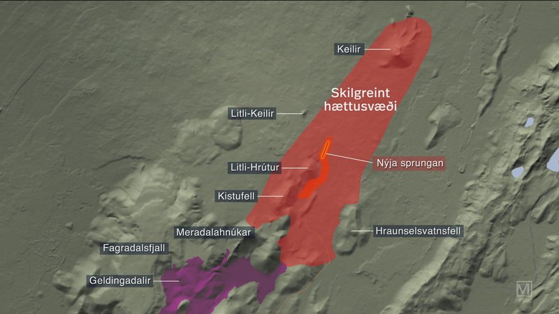
10 times bigger than Geldingadalir, possibly 3 times bigger than Meradalir, possibility of new fissures and the danger zone extends to Kelir.
Source: https://www.ruv.is/english/2023-07-10-civil-defence-press-briefing-takes-place-387534
What do they mean with “10 times bigger”? Total volume or current eruption rate? To me the eruption rate is indeed very high with the Curtain of Fires. But the volume is uncertain, because we still don’t know how long the present eruption will last.
Has to mean current eruptive rate at the time the comment was made.
Hvaldimir spying on the eruption from the bay
: D
Just joking
Im training spy penguins anyway
Defentivly not Ionian in scale I guess and I guess Io cannot do small eruptions or small lava flows at all .. Albert does the physical laws prevent yearly Earth scale activity on Io ?
Not even Eldgja is as big as the standard Ionian lava fissure but is dam close, when we are getting into Thjorsahraun then we are getting more and more into Ionian scale in terms of lava fissures
It’s kind of wild how close Eldgja and Laki were together and to the present, given how infrequent the truly massive fissure drain outs are.
I would give anything to view what they looked like at their peaks. As cool and fascinating as exo-volcanism is, it’s hard for me to invest as much when it’s “over there.” Especially because earth has had so many fascinating eruptions just in recent millennia. I’ll tell ya Jesper, for a ‘small’ eruption I would kill to see Tarawera, too. That phreatic detonation under lake Rotomahana had to be quite something.
Eldgjà was only 64 years after Vatnaöldur. Vatnaöldur 870 was an eruption of Bardarbunga like Holohraun, but much larger and more explosive. So it’s possible that after Holohraun another volcano decides to do an apocalypse eruption during the present century.
Any viscosity estimates of the lava yet? Seems to be a few 100 s pa.s near the vents and well over a 1000 at the fronts still fluid and movable but not like the vent in Fagradalshraun 2021 that coud have been as low as 10
As usual http://eruption.acme.to is ready with multiple camera views. 🌋
2021 the eruption took six months
2022 the eruption lastet 18 days
18 days is a relative normal Icelandic timeframe for small to medium eruptions
Hekla 2000 12 days
Grimsvötn 2004 5 days
Grimsvötn 2011 4 days
It’s possible that the current eruption stays in the short timeframe of small Icelandic eruptions. 2021 was extraordinary as the initial eruption.
Depends on how long it takes the feeder tube to close. I guess the quicker it closes the more likely that there will be another eruption later as there is a lot of magma under the peninsula at the moment.
Now the eruption releases a lot of steam/gas/smoke. Everything is steaming/smoking. It looks like the multiple lava fronts cause a lot of moss fires: https://www.ruv.is/frettir/innlent/2023-07-10-tilkomumikill-gigur-hefur-myndast-i-gosinu-vid-litla-hrut-387330
The plume sometimes looks as dark as an ash cloud, but it’s an optical illusion.
I saw this at Geldingadalir in 2021 when the two original cones shut down, they started smoking a whole lot, the westmost one in particular. The north 4 cones did this too, but not as much. I will just keep watching and see what happens next, as we know that cone 5 became the main one at that point.
2021 was the first eruption in Reykjanes in centuries, and that is what made it special. Shield volcanoes are usually found in weak volcanic fields with very long periods of dormancy (like the volcanic fields in Australia, Arabia, the Patagonian back-arc basaltic province, or Borneo’s Mexican shields). Being the first eruption to break out in centuries in that area may have favoured the construction of a small shield volcano, although still very insignificant compared to the early Holocene shields. The trend since 2021 is for eruptions to be increasingly shorter and more intense. It looks like Fagradalsfjall is aiming to become a more mature system, with many small, fast, intense eruptions, perhaps like Krysuvik and Svartsengi during the Reykjanes Fires.
The shield of old eruptions covers the Road 41 from Vogar to the next little bay to the east. The coast looks as if past eruptions have moved the coast 3km into the ocean. It’s possible that future eruptions of the shield volcano will cover parts of this area until the ocean again.
Fagradalsfjall may do in its Fire period the same volume that f.e. Krysuik … has done since the last active period of Fagradalsfjall. We don’t know the time span of the current Fagradalsfjall Fires. They may last 100 years and overcome our generation. So there is enough time to do a large volume and shield eruption again.
This is the first time I’ve seen anyone mention the Bornean shield volcanoes. I’ve seen them on Google Maps but I can’t find any info on them (maybe it’s in a paywalled paper). What are they called and how old are they? They look quite young seeing how uneroded they are despite being in the tropics
The closest we have been is in this post: https://www.volcanocafe.org/bawean-island/
TheBornean volcanics happened some 20 million years ago.
From all the available webcams, there’s no doubt now that the eruption has decreased considerably save for a single fountain that’s partially visible on the MBL cam.
The RUV cam which is looking along the main fissure doesn’t show any erupting lava with just ground moss, etc. throwing up a lot of smoke…while just 8 hrs. ago it was seething with fountaining magma along much of it’s entire length.
For some reason, it appears that pressure from below has been greatly reduced.
While being far from being an expert, as I see it, there are five possibilities for what’s going on:
1. The supply of magma under the current eruption zone was just a finger of magma breaking off from from the main intrusion, and thus has been rapidly depleted..i.e. low total volume, high initial eruptive flow rates, rapid shutdown? If so, then this particular fissure may be a oneofer type of event.
2. The M5.2 earthquake opened up some extra space for magma to intrude into, thus the overall pressure (hydraulically) within the intrusion at depth has temporarily decreased. Once the extra volume gets filled up, re-pressurization commences and the eruption resumes.
3. The main intrusion has found a new subareal pathway…perhaps as a growing sill just below the surface. If so, then the lateral spread of magma at depth could continue without breaking the surface.
4. A new dike is forming that’s draining off the magma supply under Litli-Hrútur. If so, then we’d expect to see a new round of rock-fracturing earthquakes followed by another eruption in a totally different locale…perhaps closer to Keilir?
5. The eruption is already consolidating into a single conduit which is acting as a safety valve that draining off pressure at depth. Without a lot of visual data to work with, it does look like only one rather weak fountain is erupting at the moment with the fissure (per se) starting to shutdown and presumably seal up? If so, despite the initial high flow rates, there hasn’t been nearly enough time to drain off the intrusion (if the data and experts are correct)…hence the eruption is simply in a transitionary period with more activity to follow?
Class is in session.
It is all about the gas. The pressure comes from degassing. In the first fissure, the fountains would be driven but the gas pressure. But this went down quite quickly. Perhaps this magma was a little stale. We are now down to just the magma pressure itself, a combination of inflow from below and pressure from the rock on either side of the dike, squeezing out the magma. By the way, the effusion rate can still be high even if the lava isn’t fountaining. If the gas gas run out, it may get replenished over time as fresher magma reaches the surface.
At least visually speaking the single fountain that remains seems to be higher than it was before the rest of the fissure shut down. It’s just really hard to pick out most of the time with all the smoke from moss fires surrounding it. As of the time of this writing, though, it is starting to clear out a bit more and the fountain is more apparent.
It does feel like the overall eruption is evolving more quickly than the last two.
Its pretty typical for fissure eruptions to become singular vents in a day or so, Mauna Loa became a centralized cone for the most part in the first day, and that was a much faster eruption than this is. Although, in Mauna Loa, the ‘single vent’ was still a fissure in itself that was 250 meters long… but that is much smaller than the 20 km long curtain of fire that the first day brought us 🙂
Probaby over this week the fountain will build up a sizeable cone, and also most likely get taller. If it can sustain itself liek happened in 2021 then the eruption will probably become episodic once the excess pressure in the dike has been released and the eruption is fed from the deep supply rate. If the cone and the vent can build up high enough then the rift could reopen and new vents form somwhere nearby.
I am hoping it rains soon to put out all the moss fires so we can see everything. But I guess if the fountain ever gets much taller they will probably just restart anyway.
Here is a new map about the eruption:
Lava has half encircled Litle Hrutur and flooded the eastern foot of Kistufell.
Its all about friction. Friction is determined by surface area, many small conduits have a much larger surface area than a single large conduit, so the fastest flowing conduit (which is simultaneously corroding its pipe) dominates.
An interesting cluster of quakes with a depth between 2.8 to 3.4 km have appeared to the east of Reykjavik Airport.
There were quakes here too in the days immediately before the intrusion at Fagradalsfjall began. Apparently inflation was seen under all of Reykjanes before this eruption, not just under Fagradalsfjall and Krysuvik like in the last two, so probably a good indicator this eruption will either be more powerful or last longer, and that we shoudl also be expecting something to show up elsewhere sooner rather than later.
But it also means probably this swarm up in Blafjoll is ultimately magmatic too, maybe not an intrusion at present but showing a point of weakness, it could be the early stages of a magma conduit that has yet to form a dike and potential eruption, somewhat like the persistent quakes around Keilir over the past years, or the deep swarms at Katla. It didnt go further before when the intrusion happened elsewhere but this place is probably one to keep an eye on for sure, eruptions in Blafjoll are not really fast, similar style to the ongoing one now, but are rather voluminous and are close to Reykjavik so problematic is being a little generous…
Yes, earthquakes are back on the peninsula and show, that pressure might build for the next stage. And Eldey is still in the game.
At the same time Vatnajökull has made earthquakes again. It can’t stay too long as dead as the Dodo.
Luckily not a volcanic area, at least not at the moment. I think it is all the volcano tourists flying in, making the planes too heavy!
it is actually, there arent any Holocene cones exactly at that spot but it is only a few km from the cones formed in 1000. The swarm is under a mountain called Vifilsfell, which is part of Brennisteinsfjoll.
Probably not going to do anything in the immediate duture but it being active now probably means it could erupt soon, in the next decade is not completely unreasonable although probably less likely than more eruptions on the west end of Reykjanes (not including Fagradalsfjall)
https://m.youtube.com/watch?v=M453G-ZxaFs
Nice views of the 2021 lava one month ago, clearly still very hot at depth
Grapevine’s current video: https://www.youtube.com/watch?v=NQ_lUC6v_1s
https://www.youtube.com/watch?v=aJP-8kLa3N0
Looking at this webcam one can still see a large plume going up. looks like it is most likely confined to a single vent.
It is impossible ( for me anyway) to judge how high the plume is and the smoke frequently hiding it doesn’t help either.
It is impossible ( for me anyway) to judge how high the plume is and the smoke frequently hiding it doesn’t help either.
It’s about 80m high at its peak, based on bomb fall times. So not exactly tiny.
Thanks for that info, I had thought it must be high to see it on that cam. But 80m is definitely not showing signs of stopping anytime soon like I was worried might happen.
https://www.youtube.com/watch?v=gKUMv1X4QIk
Here is a better view right now for timing the fountain height. 80 meters might be for the higher bursts, the continuous fountain is probably much less, but it is clear this thing isnt on its last legs. Once the smoke clears up it should be easier to judge.
Actually, the fountain is probably not nearly 100 meters, because it is much smaller than Litli Hrutur which is about 100 meters tall. The fountain is probably only something like 40 meters tall, maybe 50, so not all that different to last year although the volume of lava seems to be a lot more still.
The lava is flowing south and not too slowly either, it has already reached about 1.5 maybe even 2 km from the fountain. At this rate it will probably flow into Meradalir and onto the lava from last year by the end of the week.
Looks like it has flowed around both sides of that ridge, unless maybe another fissure opened on the far side yesterday. This was probably taken from the top of Litli Hrutur by drone, Kistufell is to the right, and looking south. I suspect we will see how far it has flowed soon enough as the area is opened up again to viewing.
The moss fires expand in beyond the lava front and is easily confused with that. The Litli Hrutur eruption Webcam shows this moss/gras fire front:
https://www.youtube.com/watch?v=_q1N4J5oTSE
The smoke hides the lava field a lot.
InSAR data (thanks
@j_p_joule
) of the first part of the Iceland intrusion (until 6 July) shows a linear deformation signal between Keilir & Litli-Hrútur (from arrow), indicating movement of a fracture that the magma appears to have used as pathway to the surface yesterday
https://twitter.com/Sjonni_KAUST/status/1678766657018425345
First look at
@CopernicusEU
#Sentinel5P #TROPOMI satellite SO₂ data for the #eruption at Litli-Hrútur on #Iceland’s #Reykjanes peninsula, showing the #volcanic gas plume drifting SW off the coast and out over the North Atlantic.
https://twitter.com/simoncarn/status/1678802414391169025
Just posted on FB…. ?stp=cp6_dst-jpg&_nc_cat=103&ccb=1-7&_nc_sid=5cd70e&_nc_ohc=UETYR0GkofkAX9Xuaxc&_nc_ht=scontent.ffxe1-1.fna&oh=00_AfCeES-0FknXQEiJOGcbHRZyOONasecd9Jiqm2_uY2LHkw&oe=64B261EA
WHOOPS!!!! OK….I put it on the ‘cafe’s’ page…
Interesting trace on the FAF highpass, past hour or so, not sure if the last big spike was a small quake close to the seismometer. The trace seems still after that quake – see
That looks like an instrument malfunction.
FAF is located in the direction that the lava is flowing. Not sure how high up it’s placed. Missing in action?
Not a casualty, but they are moving it since it was threatened by lava. I assume the blip looking like an earthquake is a transient from turning it off.
From ÍSOR facebook page (auto translated)
During these upheavals in Reykjanes, one of ÍSOR’s seismometers (FAF east of Fagradalsfjall) has been invaluable in natural hazard monitoring due to its location, both for more accurate location of earthquakes and no less for monitoring volcanic eruptions (see picture). Now, however, the lava flow in the current eruption is heading straight for FAF, so we are forced to remove the gauge in cooperation with the Icelandic Meteorological Office and the University of Iceland. He will be sorely missed! On the accompanying turbulence graph by FAF from the Icelandic Meteorological Office, it is clearly visible when the earthquake series that followed the magma movements began, and then when the volcanic eruption began yesterday, on July 10 at 4:40 p.m.
ÍSOR has been working with the Czech Academy of Sciences in Prague since 2013, and the academy has operated 17 seismometers on the Reykjavík Peninsula in cooperation with ÍSOR. The earthquake monitoring network, called REYKJANET, covers the peninsula pretty well up to Geitafell in the east, see green triangles in the picture. These gauges have recorded earthquakes on the Reykjanes Peninsula continuously for the last few years, together with the Icelandic Meteorological Office’s gauges on the peninsula (blue triangles in the picture). The cooperation between ÍSOR and the Czechs for the last 2 years has taken place within the EEA-funded research project NASPMON, which included, among other things, all seismometers put into real time streaming. In order to obtain a better resolution of earthquake locations for natural disaster monitoring due to the earthquakes that began in February 2021, earthquake data from 8 of the 17 seismometers in the REYKJANETI began to be streamed to the Norwegian Meteorological Agency from ÍSOR. This is done with a special agreement for natural warning monitoring, and together these measuring stations have played a key role in natural warning monitoring on the Reykjanes Peninsula since the upheaval began, and also for further understanding of what is going on there.
Thanks for the update
RUV: Volcanologist Thorvald Thortharson assumes that it’s possible that a new intrusion develops at Reykjanes peninsula. New data show that it has moved to northeast close to Keilir. This could mean that new eruptions may open to the north of the present eruption. A new intrusion would face the same difficulties to overcome the last km to the surface. https://www.ruv.is/frettir/innlent/2023-07-10-opid-ad-gosstodvunum-387330
Regarding the facebook post about the FAF seismometer, maybe it is a translation issue but it sounds like they are simply removing the seismometer and aren’t going to place it somewhere else? That would be a shame…
Never mind. It looks like it is being relocated per a blurb here: https://www.ruv.is/frettir/innlent/2023-07-10-opid-ad-gosstodvunum-387330
Or the link in English
https://www.ruv.is/english/2023-07-06-ruvs-cameras-at-eruption-site-387112
They’ll install the cameras at that new overlook at the end of the trail recently posted. Then, as with the previous events, all the volcano site seekers can do their“made it ma top of the world“happy dances to the detriment of the intellectually, gifted in geology.
Aaaaarrrrgh! Please no! I couldnt bear to see such a variety of rear ends again! It was definitely once seen never forgotten!
Pop yourself some corn, a couple of buckets and pull up a chair. I have every confidence that, to borrow from ZZTop, you’ll be look’in at some tush.
That was in winter. Summer bums may be more interesting?
Dan, thanks to a comment by Tomas, I went to look up the seismometers in the ISOR network and found this page https://en.isor.is/updated-map-of-the-seismic-network-on-the-reykjanes-peninsula-in-sw-iceland/ however when I landed on it, the content of that page appears to be hacked. Can someone please verify?
Thanks!
Looks like hacked, or just holding text while they set it up.
Isak Finnbogason is hiking up the trail towards the eruption center to do a drone shoot. He’s done this the last 2 days. He mentions that a lot of people are on the trail now. Hopefully the drone session will start in 1/2 hr or less – see https://www.youtube.com/watch?v=LctsbmtkTT0. He has 1,567 people waiting to see the drone pictures for today.
OMg the moss jokes on Isaks chat while everyone is waiting!! 🤣. Just how many puns can you make with the word moss? I feel like some of the VC spirit might be channelled in that chat!
I suppose its my age, but I’ve found a lot of that yada yada both on the Icelandic YouTube channels and those out of Hawaii during the events, to be braindead banal, monopolized by a few individuals who coopted it for their own personal social media ‘party on dude’. . Just say’in….YMMV!
I agree that normally the chats are dead boring. But everyone got on board with the moss puns while waiting. I found some of them hilarious for a change. 🤭
finally operational at 19:51 local time.. longer wait than expected
Center cone has calmed down, much like the center cone at Geldingadalir in the first few days.
I’m subscribed to Isak’s channel but can’t seem to replay his recorded video. He has tech issues to be resolved. There are certainly impatient people out there who place comments which suggest they feel they’re in some kind of entitlement program where these channels are concerned. UFFF!!!!
Please take another look at https://www.youtube.com/watch?v=-YUXO8ne12w take a look now.. fantastic shots.. right in the heart of the center fissure center. Any closer and you’re toast.Isak had to update his software, but the present views are fantastic!
He fixed the issues, and the stream is smooth as silk now (it started a new one though). He’s getting some spectacular views!
https://www.youtube.com/live/-YUXO8ne12w?feature=share
I guess it is the same URL after all.
Took a break for dinner. I logged into YouTube home and input his link so I have it now. It will be possible to review the entire recording. This edifice is developing the way ’21’s did with one sluice way out. I’d like to see that close and the entire cone over flow, but that never happened with ’21 even though the channel evolved.
GutenTag has released some interesting video from last night, putting some perspective on the size of the fissure erupting centers as compared to the average person, see https://www.youtube.com/watch?v=cbDETtH9f1I
Thanks for the link. His work has always been thorough and exhaustive. Agree that the size perspective puts the event in a whole different light. There’ll likely be more ‘from the ground’ video once that hiking path to the observation ridge is opened. If negotiable, I have no doubt that ‘the usual suspects’ will find their way downslope to the old lava field and approach the flow toes.
They can’t exclude new fissures with little warning. The danger is not over. The most likely location for new fissures is still close to Litli Hrutur, but the whole “danger zone” includes Keilir. At Keilir does deformation continue, magma is moving to the north.
Source: http://www.ruv.is
Map with danger zone:
https://youtube.com/live/-YUXO8ne12w?feature=share8
Isak has started a new livestream having updated some software.
Drones have made another new step forward as far as volcano monitoring is concerned. They’re invaluable now.
21.58 pm stream time we see the current extent of the flow into the narrow valley, overrunning the cycle track.
At 20:20 local time a small earthquake at mag 1.3 – 1.4 just occurred at 1100 meters depth right underneath the fissure line. Maybe an isostatic adjustment? See https://vafri.is/quake/#close on this.
Beware! That’s a default depth assigned to poorly constrained hypocenters. Never trust a quake that’s not yet been manually checked and relocated, especially when it comes to depth (which has a large margin of error). I recommend turning off unverified quakes when watching the vafri.is page.