
It is hard to remember what Iceland was like three years ago. At that time, most (or all) eruptions were in the eastern volcanic zone, from Katla (and friends) to Krafla. (Ok, one can argue about the precise borders. Grimsvotn was about to erupt. The Thorbjorn swarm had happened and an eruption at Reykjanes was seen as possible, but the peninsula had been quiet for 800 years. This was when we postponed the eruption to 2021 due to covid (cue: April 1). Iceland followed our lead and indeed in early 2021, after an impressive series of earthquakes on the Reykjanes fault, an eruption followed in the most unlikely location: Geldingadalir, a remote valley within Fagradagsfjall, where no eruptions had occurred for perhaps 30,000 years. Who would have guessed? Since that time, there have been three eruptions in three years. And we are still waiting for Grimsvotn.
The first Fagradalsfjall eruption was perfect tourism. It was in a location where no one was endangered, while still easy to reach for the watchers. This being Iceland, webcams were put up in various locations, maintained by the locals and watched around the world. Of course, this being Iceland, the locals use the cameras to display themselves and even slogans were put on view, sometimes to the watcher’s entertainment and sometimes to their annoyance. But when entertainment is provided for free, it is hard to begrudge the occasional advert! The eruption evolved through fissures, effusive cones, tall fountains visible from Reykjavik (lucky things) an finally sputtering. We learned that Icelandic eruptions can be controlled. A wall was build to deflect the lava, and indeed the lava was deflected. The same was attempted at the place where the lava began the threaten the road and farms, and immediately the eruption ended.

The power of Iceland was obvious in many ways. As Reykjanes sputtered into action. Etna was delivering unbelievable fountains, tall enough to keep even Jesper happy (perhaps not Tallis). But it stood no chance. The eyes of the world were drawn north.

It ended after some 6 months. By that time the original valley of the eruption no longer existed, and neither did the deeper valley next door nor the hill were the first lava emerged . Iceland was left with new geography and a new hill which still has a warm conduit, and we were left with happy memories.
A year later came a new eruption, an afterthought of the first. We had kind of expected that the Earth was not finished here and that at some time the magma would break through again. It happened in the northern part of the original eruption. The eruption was much less vigorous, and season II was a pleasant sight but not on par with season I. The lava field expanded a little but that was it.
For the start of Season 2, see
https://drive.google.com/file/d/1PKzvTGMTr_Iln5VijqOosRj_SiyYNQlX/view
But intrusions continued, last winter and in the spring. As before, a dike sprung up and expanded in a NNE-SSW direction. The location of the deeper magma source is not so easy to determine. The first intrusion had been further west. This being a zone with a bit of extension, there is a region some 5 kilometer wide below which magma can collect. From there, dikes can grow. Some are very deep, tens of kilometers. This go north, and can continue for 50 kilometers or more but they never reach the surface. More common are shallower dikes at 5-7 kilometers which do not go very far but quickly move up. The current intrusion was focussed further north than might be expected, with the upward growth southeast of Keilir. But it is not clear where the magma originally came from. The earthquakes and insar showed that the dike extended between Keilir and Litli Hritur, just north of Fagradalfjall.


The eruption started today at the bottom slope of Litli Hrutur, with a 900-meter fissure extending about half the distance to Keilir. As I am writing this, the lava is beginning to flow around the hill but it is not clear to me in which direction! And sadly, the eruption is too close to the cameras for a good view! I am sure that will be fixed. This is Iceland, after all. They will try to move the eruption.

What will happen next? The eruption had a sluggish start, surprising perhaps after the vigorous dike formation. But this was also the case in Season 1, and in any case the volume seems to have increased a lot as the fissure lengthened. This could develop in an event similar to series 1, lasting several months and covering a large area but well away from roads and houses. It could also be a rerun of Season 2, lasting a few weeks. The former seems more likely given the intrusion, but this is not certain.
Viewing will be harder than for Season 1, being further away from the road and requiring a longer walk. But I am sure that the coffee van will be appearing shortly at the parking area, ready for the thirsty tourists. We are in for a treat.

Location of the dike. Initial lava flow shown in blue
Albert, July 2023
And here is a reflection by Randall, taken from the comments
My own personal observations of events leading up to the fissure eruption.
- The website https://vafri.is/quake/#close posting quakes proved invaluable this time for knowing how events were progressing. I watched the screen literally hours and began to discern patterns. Once there was like a surge and small quakes burst out over in the Krisuvik area and you could follow this surge by watching for about 1/2 hour or so. I took this to mean a magma surge. The constant activity to the NE showed that pressure was high.
-
A key comment made by Tomas Andersson about triggered quakes related to the inSar butterfly picture helped me to understand the quakes occurring on the vafri.is/quake website for the past 3 days.
-
The FAF seisometer was a good source of watching the microquakes, and I am sure that at least 3 episodes (barefuly distinguishable) of microtremors occurred. The time from 14:50 pm to 18:00 pm today (2023-July-10) on the seismo shows a slightly thicker trace. This seems to indicate that actually watching microtremors is a very difficult science even today and fissure eruptions are still hard to accurately predict
-
The strong 5.22 quake yesterday had few aftershocks, indicating (my terms) mushy ground or softened up ground by magmatic intrusion. This in hindsight was an indicator of closeness to the actual eruption.
-
There appears to have been a small microquake around 16:38 pm which slightly shook the RUV cameras on Litli-Hrutar, and I take this as the final breakthrough of the fissure. IMO dated the eruption at 16:40 and the RUV north camera showed the first smoke at 16:41:07 pm. It is really hard to catch fissure eruptions as they first begin.
-
The two flights of small birds that I saw around midnight Iceland time were interesting. Birds seem to have a foreknowledge of events, and their flight path was directly away from the region at about right angles to it (giving them the maximum distance via minimal flight time) Before the Hebgen Montana 7.3 quake of Monday August 17, 1959, the water fowl left Hebgen Lake about 2 pm in the afternoon and their absence was noted in the sheriff’s log at West Yellowstone. The quake that evening gave the reason why the waterfowl left. They came back to the lake after the 3rd aftershock on Wednesday Aug 19th or so. My dad took our family to this epicenter about 2 or 3 days later and we saw the lake filling up, and all the damage and trees disappearing into the water and it left an indelible impression upon me as an 8 year old.
-
Scientifically things have improved, we’re in a better knowledable condition that when the 1st eruption started back in 2021.
-
The hot water pouring from the borehole in Avedir (spelling) was definitely a sign of nearness of the eruption, but it was 11 km from Keilir. That is a wide area for a thermal pulse to travel. Do we know much about how much thermal energy is spread when a dike intrudes? More studies of borehole water and temps needs to be done.
-
Several people on Volcano Cafe gave fairly accurate predictions of the location of the fissure eruption, I believe Albert might have been the first to speak up. Chad gave one as did Alice, but there were others and I apologize for not mentioning you.
Finally the excitement leading up to a fissure eruption is almost addictive. It really is fun watching a volcanic event like this occur, especially when it is fissure eruptions which have not occurred for some 800 years.
These are some thoughts as I reflect back through events leading up to the fissure eruption today.
And a response to these: the hot water can easily flow 11 kilometers, so it may well have come from the region around Keilir. The underground rock insulates well but underground water can circulate and transfer heat very effectively when coming close to the magma. Gas emissions can also heat up the region. As to the birds, this was commented on below. It seems unlikely they predict eruptions, and in fact I recall tropic birds flying very close to the eruptions at Kilauea. They may be affected by earthquakes, of course, and perhaps by the SO2 emissions that can precede an eruption – Albert


https://m.youtube.com/watch?v=nFGMDvHRiy8
The lava looks quite viscous ( still fluid ) but yes much less fluid so than 2021 s summer
Could it be its still pushing out older material from the previous eruptions?
The lava from the main vent is actually very fluid. First chemical analysis here: https://jardvis.hi.is/is/gos-vid-litla-hrut-2023#main-content
Very similar to 2022 and 2021, ~1190°C. Current drone livestream shows a very fluid lava river as well.
This is how crystal rich the lava is
Now that faf is no longer recording, does anyone have a suggestion for the next best station to watch on the drum plots or tremor?
Thanks in advance!
I’m watching ASH, which is to the northeast about 4 km from the eruption (2.6 km east of Keilir.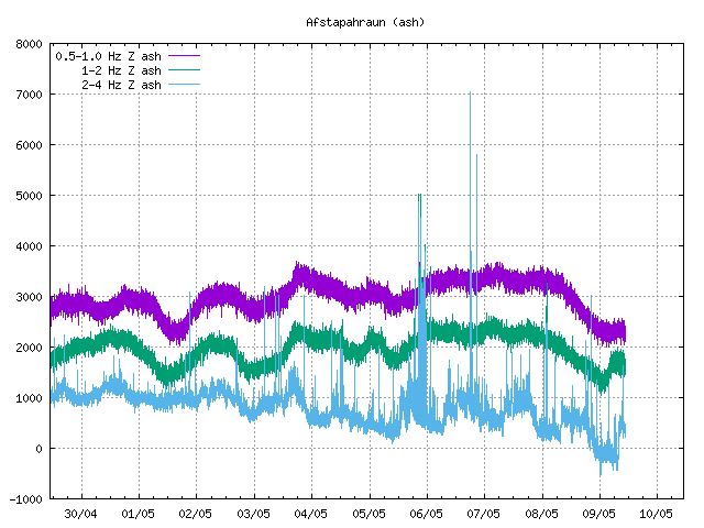
Thanks for the info!
Isak is flying drone again. Get ready for closeups.
Amazing lava river, reminds me of Kilauaea 2018 but smaller. Saved a clip here: https://youtube.com/clip/Ugkx1WWckrlCzJfZLCMi1GzCoNrsD95dnjV3
Some really good video
And sunset
On the RUV news, translated with Google translate.
The magma tunnel extends under Keilir
This new magma corridor is news.
Þorvaldur Þórðarson, professor of volcanology, has said that it is possible that a new magma intrusion is forming on the Reykjanes Peninsula. He explained it in more detail in the evening television news.
“There is deformation going on in the direction of Keili, which indicates that a new magma is in the process of adaptation,” he says. The magma tunnel seems to be moving northward.
If the inflow of magma is greater than the outflow in the eruption, pressure builds up. “That way we could start making more fissures.”
But what does it mean that the magma tunnel has come under Keili?
“Of course, it can have the effect of creating a crack through the mountain,” says Þorvaldur. Lava could then flow down the slopes of the mountain and change its shape from the cone we know today, and the mountain is named after it.
As mentioned before, however, it is considered most likely that new cracks will form closer to Litla-Hrúti.
At 1:07 am local Iceland time there is a LOT of lava flowing from the central fissure center and it is making a wide river flowing south. I hope someone can give an estimate on the flow rate, but I’d guess > 50 m^3/sec rate easily
My fave thimg is to watch the cones build…and then crumble
I got to see a bit of that this afternoon on RUV’s stream…in between tourists mugging for the camera or just absentmindedly standing in front of it.
Where is the volcanohead Avatar icon dear Spike?
You made that iconic thing 🙂
There is a guy close to the active cone center at 1:21 am in the morning watching this eruption close up. I don’t know whether to commend the guy or be critical. https://www.ruv.is/english/2023-07-11-live-streaming-from-eruption-new-camera-location-387597
“Our field group has arrived and with the first map of the lava from the gigs at Litla Ram that shows the situation at. 21:36 pm, July 10, 2023 At this point, the lava’s advancement to the south had next stopped (at least temporarily) and began to spread to the east and thicken. Similarly, the lava flow to the east or north was unrealistic. At the time of history, the lava had covered 162 000 square meters and its cubic meters (calculated as a dense rock) corresponded to 730 000 cubic meters. This gives a production of 40 m3/s, which is 10x more production in the first 39 days in Geldingadalagos and 5x more than the production in the eruption in the period from May 1 – September 18, 2021. Although the initial phase of this eruption is more powerful than in the 2021 and 2022, this eruption also is small and as it stands, the lava width is small in size. Most likely the power (=productivity) of the eruption will be reduced in the next hours and days and the final size of the lava breadth will primarily be affected by the length of the eruptions.
Even then this is the third eruption in Fagradalsfjallseldur and it seems normal to us to blame it to Litla-Hrút – r. and. The Little Aries eruption 2023. one of the symptoms of this eruption is miscellaneous, but screened cracks (see attached map).
Our field team is back from the site with a preliminary map of the lava field and vents current as of 21:36 on 10 July 2023. By this point lava had ceased advancing south and was branching out (i.e., dispersed flow) and building up. The advance of the lava to the north or east is negligible. At this time the lava had covered an area of ~162 000 m2 that gives a DRE (dense rock equivalent) volume of ~730,000 m3 and a time averaged discharge rate (TADR) of ~40 m3/s DRE. This is exactly 10x the TADR for the first 39 days of the 2021 Geldingadalir eruption and 5x the TADR for the reminder of the 2021 eruption (after 2 May). So, although the initial phase of the 2023 is somewhat more powerful than that of the 2021 and 2022 eruptions, it is still a low intensity event and as of this moment its magnitude/size is small. The intensity is bound to fall in the coming hours or days and the final size of the flow field will depend mostly on the eruption duration.
This is the third eruption of the 2021-ongoing Fagradalsfjall Fires and it seems logical to refer to it as the 2023 Litli-Hrútur eruption.
A striking feature of this eruption are the variably offset en echelon fissures (see attached map).”
So for the first 5 hours of eruption the output was 40 cubic m/s of lava, but then rapidly decreased to 10 cubic m/s
There is a HUGE breakout visible in the RÚV live cam that started when a massive lava boat sailed out of the cone and then pulled an Evergiven in the channel right outside it.
Thanks for posting that! I was asleep at the time and was able to scroll back and see it just now, Watching closely the lava boat came from a wall breakoff from just inside the cone, Fascinating to watch.
Thanks to the people (counted 11) near the active vent,now have better idea how large its grown- now has a similar feel to 2021&2022 eruptions.
11 July at 04:50:07
(English below)
On that ruv. is a picture from this morning you can see that the power and productivity of the eruption at Litla-Rút has significantly reduced. The southern rim of the lava seems to have stopped and with it the drain has spread and stretches more eastward. The production appears to be similar to that measured in previous eruptions (~10 m3/s? ).
In this context, it is only right to mention the release of fossil in the eruption. If we assume that the composition of the mercury is similar to the one that appeared in the earlier eruptions of Fagradalsfjallseldi, then according to the experience formula of viðorvaldur Efórðarson, it would. fl. (2004), production of ~40 m3/s emits about 16000 tonnes of SO2 into the atmosphere per day. The eruption appears to have held this production for the first ~5 hours, which means that at that time the eruption emitted just over 3000 tons of SO2, which is equivalent to ~600 tons/h. , and explains the pollution that was around the fire stations at the beginning of the eruption. But since the mercury production has been significantly reduced, the same nature has reduced the sulfur pollution and it has probably dropped to ~4000 tons / day or about 150 tons / hour.
Judging from the attached ruv.is image the intensity and the magma discharge of the 2023 Litli-Hrútur eruption has dropped significantly by this hour and the southern branch of the lava appears inactive plus the flow is dispersing to the east. The discharge now appears to be roughly at par with what was observed in previous events (~10 m3/s?).
In this context it is worthwhile mentioning the release of SO2 from the eruption. If we assume that the erupted magma has similar composition to that erupted in 2021 and 2022, then according to the empirical formula of Thordarson et al (2004), magma discharge on the order of 40 m3/s would release about 16000 tons of SO2 per day into the atmosphere. Hence in the ~5 hours that the eruption maintained this discharge it would have released just over 3000 tons of SO2, equivalent to 600 tons of SO2/hour, which explains the pollution level at the eruption site. As the magma discharge dropped so did venting of SO2, which at this time is most likely around 4000 tons/day, equivalent to 150 tons/hour.
Rough start visually. Need the moss to finish burning. Listening to Isak hee haw and dial 911 about people walking in the smoke is annoying. He needs to focus on the quality of his drone images; not playing a safety virtue mall cop. Sounds like a worry wart american mom. Shushhhhh. Shrug.
I can’t believe I miss gutntogs shaky vids.
🙂
Why is there still so much smoke on the northern lava field even after the eruption ceded there? https://www.youtube.com/watch?v=yJfiMhqLgTY
[youtube https://www.youtube.com/watch?v=yJfiMhqLgTY&w=1174&h=660%5D
It will keep smoking for a while. The rift is still there so the gas can get there. AT some point the smoke may turn white, showing it becomes water vapour. The main problem is actually the good weather! More wind would disperse the smoke faster
Is there a heat flow outside of the lava field that causes moss fires to the north?
Building itself a nice cone now as the magma flow focus on one conduit dyke channel in the fissure system
I wonderful What the same process woud look like on Io with 6X less gravity woud spatter cones even form like on Earth when lava flys further in the low gravity? they are soure to be broader and larger than on Earth because of that
There are still quite a lot of quakes happening under Keilir, in 2021 this was given as magma rising but it was pretty clear the intrusion started there but today that is not so much the case, the intrusion seems to have started more southward on the rift than Keilir, so the quakes there are probably magma pressure. The existing vent is still going strong, but evidently it isnt enough, so things could get interesting as the week goes on.
While the eruption has begun, parts of the intrusion are still in a “pre-eruptive” phase like two days before. They expect more fissures to happen in the whole orange area:
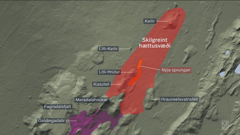
It’s most likely that new fissures (“sprungan” is singular form for “fissure” in Icelandic) open in the southern part.
: D Im going to hike eruptions when I moves to Iceland in the future, as Scandinavian Citizenship Im Icelandic Citizen
Just not soure what to work with, Im back to square one again with disabeld foot : (
https://twitter.com/ICEYEfi/status/1678858149942509570
ICEYE’s data has helped to predict the location of the recent eruption of the Fagradalsfjall volcano in Iceland and to infer the depth of the lava. The data was used by the Iceland Met Office which is closely monitoring the volcanic unrest in the Reykjanes Peninsula.
Thanks for this post, now I can see what the IMO and others were relying upon to say that the dike has migrated northward, it is very obvious from comparing the 2 inSAR pictures.
Great video from the start of the eruption. Close up view of moss catching fire from hot gasses, followed by spattering lava.
https://youtu.be/yanlRDo8kkU
It shows that heat flow and burning moss preceded the lava extrusion. It’s possible that current moss fires are as well driven by heat flow from further parts of the intrusion that are still below.
My assumptions were that thew moss is just flammable in the wind and in the warm weather. Its actually really not cold there at all now, something like over 20 C. That there is a volcano nearby is probably not too relevant now although probably warms things up downwind.
The moss fires add even more poisonous gases to the volcanic gasses. F.e. Carbon monoxide. That’s a reason to avoid the smoky/gassy areas. The gasses are in general the largest threat for humans there.
I agree, I think the moss fire is now propagating by itself, it is only ignited actively at the point where lava touches it.
In the livestream yesterday people where walking through the moss fire and smoke to get closer to the volcano. I guess a rainy day would put out the fires in most directions from the volcano, except where the flow now propagates.
There was just a small quake at 1 km depth right under Keilir. Was also only mag 0.1, so very small and maybe not even really a quake but related to magma movement. There are a substantial number of quakes right under Keilir at about 3 km depth.
Presumably this area will erupt soon. Whether the current vent is still going is different but it will still be this eruption as the intrusion is the same one and not a new intrusion. Looking at the live though the fountain is going strong, probably over 50 meters now, and the long cone that has formed around the active fissure segment has probably got a lava pond in it that is drowning a lot of the fountains. That is the first stage to a lava geyser like 2021, as the cone grows so does the lake, until it eventually stops the eruption. After that we either get a lot fo episodic fountains or it opens the rift again 🙂
This is on par with what Icelandic geo have been saying. It seems they’re fully anticipating more breakouts further along the dike up towards Keilir. Statement I saw this morning felt it was “very likely.”
Channel feed Aa flow : ) everyone is unique in shape, yet they all look the same
I’ve just seen a small aircraft flying over the site. I wonder if that’s the survey plane; I saw another yesterday afternoon, I didn’t mark the time, alas.
https://m.youtube.com/watch?v=_SfH7t3eP24&pp=ygUVaWNlbGFuZCBlcnVwdGlvbiBsaXZl
Nice view of the main vent looks alot like Mauna Loa s 2022 vent althrough is smaller the lava is as hot as 1190 c too
Yes, it reminds to Mauna Loa’s final vent 2022, but less rate and more gas. One important difference: Mauna Loa has a steeper slope than Fagra Shield at this site.
As the only decent live view, it is a pity the RUV Driffellshraun camera would sometimes zoom out. It seems to be locked onto the main vent at full zoom when there are other active areas..
You may already be aware of this site, but if not, here’s a pretty good collection of webcams to view the eruption.
http://www.livefromiceland.is/volcano-webcams/
The vents from the past 3 eruptions compared. I wouldnt be surprised if some more vents appear close to Keilir some point before the end of the week though, it has the same swarms of quakes under it now that happened underneath Litli Hrutur a few days ago.
This sequence kind of reminds me of the sequence of the Krafla fires, the initial intrusion of that rift was way bigger but still there were only small eruptions up until 1980, and many dikes didnt erupt at all. But in 1980 eruptions pretty abruptly became way bigger as the rift was full so the only way left to go was straight up, instead of formign a dike nearly all the magma was erupted in the later events. These got pretty crazy like erupting 50 million m3 of lava in a day or so, nearly VEI 4 level effusion rates. I dont think that will happen at Fagradalsfjall exactly but something similar where the eruptions get larger and more intense over time. In 2021 I compared the eruption to the 1730s eruptions on Lanzarote. That was maybe a bit premature but the point made then still stands, it might take 20 years instead of 6 but when it is all over there probably wont be a single stretch of the active rift (orange) that hasnt seen an eruption, and as the rift is fully opened future eruptions might utilize much more of it all at once.
I went to Krafla this past November and we hiked through damn near glacial conditions at the time. That whole area is spectacular though that was the wrong time of year to observe specific volcanic features. The area around Myvatn is a volcanic wonderland.
I prefer touring Iceland with snow but that has its trade offs, and it’s hard not to go when you have the best odds of seeing auroras. Still, I would love to hike Krafla in the summer and actually get to tour the area properly.
I took video near one of the geothermal plants in the area and it looks like I’m at the South Pole, it was before the November warm up hit last year.
Fagradalsfjall is the only “real” shield volcano of the Reykjanes systems. Its eruption probably evolves towards the final shield eruption which floods the whole north until the ocean. Then we may also get lava tubes and several more shield volcano features… like Puu Oo.
If we look at Mauna Ulua, it didn’t begin with the shield eruption, but 1969 with smaller fissure eruptions that preceded first the fountain phase 1969 and finally the “main” shield eruption. Puu Oo 1983 like Fagradalsfjall did many breaks between the fissure/fountain eruptions until the shield phase began. Shield volcanoes appear to need time to evolve their typical behaviour. We haven’t witnessed many in our livetimes.
How far north-east do the rifts extend? I do wonder if we won’t see repeated eruptions ever further northwards, in the years to come.
“A land model has now been created based on the images and by comparison with a land model (Icelandic DEM), a difference map has been calculated that shows the thickness of the lava. The results of the measurements are that at 18, about 25 hours after the start of the eruption, the volume of the lava was 1.7 million m3, which corresponds to the average lava flow during these 25 hours being about 18-20 m3/s. The flow was highest the night before and probably the maximum flow was over 50 m3/s. The lava flow was probably close to 15 m3/s on the afternoon of July 11th.
It is planned to gather more information in the near future and monitor the development of the lava flow.” https://jardvis.hi.is/is/eldgos-vid-litla-hrut-nidurstodur-maelinga-11-juli
First results from samples of Litli-Hruti eruption
New data from the #Fagradalsfjall eruption!
We find that the eruption at Litla-Hrút has a composition similar (but not identical) to the one erupted last year at Meradalir. The whole rock MgO and K2O/TiO2 are very similar, 8.5 wt% and 0.26, respectively.
Not strange because the lava erupting looks exactly like the 2022 lava
The amount of MgO (8.5 %) indicates that it is more or less straight from the mantle, just like in 2021/2022. It would be interesting to see the tiny differences, though. I’d expect that there is a common source for all three eruptions (not a magma chamber, but a pocket or accumulation of some sort with a very short connection to the mantle) but not a direct mantle connection.
Hello all
I took the 2 insar images from ICEYE twitter post and overlaid them on Google maps for Iceland and made a video of this. You can see how the bulge (concentric circles) slightly move upwards to Keilir the last two days. Hopefully you can see how the displacement relative to the satellite SAR radar has changed.
Please see https://drive.google.com/file/d/1mfCs4QTmLOD2QOL9CrZLCqCdUGwlTZat/view?usp=sharing
Sorry about this situation, I am going to have to figure out how to redo this so that a video can be posted okay to everyone at Volcano Cafe.
https://m.facebook.com/story.php?story_fbid=pfbid0u2mYvZ1X1EdqdUrZHFhSAmZMUHbuu51UXz6gM3Za94btx5BCk5Mh3Bm9uFGBb5NZl&id=605552037&sfnsn=scwspmo
I came across this post, it’s by the same chap whose drone screen showed the first live lava. It shows the opening up of the 4th, southernmost fissure.
Thank you for this video post. Indeed catching fissure eruptions as they occur is a difficult feat. Right now even the best scientific equipment we have is still not good enough to locate these fissures to within 100 meters or less.
Perhaps the use of more seismometers such as the optical seismometer (see http://siaudioseismic.com/ ) might work so that rapid triangulation can occur.
It is a very sad fact that the high tech instruments today are being unsupported and abandoned, for example the world class STS-2 Streikhausen Seismometer has been abandoned as far as support is concerned and governments around the world are scambling to find a substitute with the same high quality. See https://streckeisen.swiss/en/products/sts-2/ about this current situation.
Basically the support of science has been eroded and in some cases allowed to expire. Personally I am upset about this ongoing situation but public awareness is a first step.
Unfortunately, it’s not likely that public awareness is going to magically fix a deepening structural demographic crisis. We’re probably looking at a mini-Dark-Age, but that will likely be followed by some kind of renaissance. But it might be our grandchildren who get to enjoy that one, as our grandparents enjoyed the prosperous and fast-advancing post-WWII boom time that brought us commercial air travel, modern household conveniences, women’s liberation, at least lip service to racial equality in most places for the first time, human footprints on the moon, and at the tail end of it, personal computers and the Internet.
Of course, this is all presuming we don’t blow ourselves up or melt the planet during that mini-Dark-Age … and it leaves out the wild card of China, which might not have become mode-locked with the rest of the world via dynamic entrainment as it only became a participant in international trade quite recently. (Or perhaps the period of the one-child policy merely delayed things.) It would be quite typical of the farce called “history” to locate our Foundation in such a way that we must pin our hopes on a despotic regime. :/
Meanwhile, the eruption seems to have lost some vigor in the last day or so. Are we sure it’s building to opening more fissures rather than just waning?
As someone who doesn’t buy seismometers on a regular basis I’m just wondering why the obvious solution isn’t to replace an STS-2 at end of life with the STS-2.5 which the Streckeisen website says is the upgraded version of the STS-2 and replaced the earlier model in 2010?
https://streckeisen.swiss/en/products/sts-2.5/
Okay, I believe I am abiding by Google Maps Terms of Service, I used inkscape to create the following map. I apologize that I cannot overlay the InSar images from ICEYE, who posted on twitter, because I am simply unable to contact the company for copyright permissions.
The center of the Insar displacement has indeed move closer to Keilir, from July 7th-8th as compared to July 9th-10th. While ICEYE did NOT give the cm measurement per fringe, I believe that the 8 cm displacement is valid for July 7th-8th and (my manual estimate) a 3-4 cm displacement for July 9th-10th, thus showing pressue has NOT been fully released by the current fissure breakout.
In the map I denoted the two locations of maximum displacement and used a purple line to denote the current fissure location.
Please note that I am trying to do the best I can provide as scientifically accurate, but the data posted to the internet leaves much much to be desired.
Please see https://drive.google.com/file/d/1boCf_ahcHo3fOgsmZZYcwl1EOSA7z_tX/view for the snapshot.
Please see https://twitter.com/ICEYEfi/status/1678858149942509570 for the ICEYE post which left out the terrain map, it has to be added to accurately determine where the maximum inSAR displacement has occurred.
I apologize for the rather meager quality of the data here, I personally wish higher quality digital data could be released
Randall
https://youtube.com/live/AqkEFRWB6_0?feature=share8
Isak is broadcasting live for the third evening. The lava has not yet passed out of the Kistufell side valley south towardsMeradadalir. A decent breakout is making the attempt to go east around the end of the north-trending ridge.
And lots of people are walking on lava which is less than 48 hours old.
I think as I see, peole are walking on burned moss, this is not lava.
No, they are actually walking over the recent lava field and crossing the fissure line. If tourists are to be allowed into the area, it should be under some form of supervision including safety advisers.
Iceland could face a severe backlash if any countries tourists are melted.
Most early footage how recent eruption started.
https://twitter.com/WxNB_/status/1679251403569524737?s=20
Yes, that’s the same footage that I shared above, direct from the creator.
Does he have an unedited video of the entire event?
I don’t know, he published the reel on his own facebook page and in the goup “Iceland Geology/Seismic &Volcanic Activity in Iceland”.
There’s a piece on Visir, the English translation is atrocious.
https://www.visir.is/g/20232439348d/nadi-mynd-bandi-af-nyrri-gos-sprungu-ad-opnast?fbclid=IwAR0lqFBXblMYWsZ5pYMCQq6640weDkdqroSBcI3exZGB71C6CaLKxpfsXzw
He might have opted to capture it in intervals as being more economical in the use of his battery than letting the drone hover and just run. More to his purposes. Science thinks differently.
The eruption seems like it decreased in lava output further today. The displacement suggested this was going to be a bigger episode. Indeed the lava output was likely over 50 cubic m/s at one point, but now just a few days later it’s likely a 5th of that. I have all these thoughts. Does the earthquakes near kelir indicate new fissures are going to open up around there? Will it be too hard for magma to break through that area because of the geography or lack of pressure? Will the eruption just end in a week or two?
It isnt unusual for early eruptions in rifting events to be small, even if the intrusion gave expectation of something bigger. The 2021 eruption was unusual for being quite big even if very slow.
At the moment probably the majority of the magma is still going into filling in the rift, which might still take some years more as there isnt a magma chamber to fill it all in one go. But once that happens the eruptions will probably get stronger and erupt at the rate of supply. Given the supply of the dikes has increased each time this could result in some pretty serioys flows, maybe like those of its neighbors.
This is still early days, the Krysuvik and Reykjanes fires in the last cycle both lasted at least 20 years with numerous eruptions, with the largest at the end typically. 🙂
Another way to put it, if you remember how tiny the 2018 eruption of Kilauea looked in the first few weeks, a trickle of magma reaching the surface while a flood was moving underground. When all the underground space was filled the monster revealed itself as the biggest flow on land since Laki, something not even the seasoned veterans of HVO thought was possible. Fagradalsfjall isnt going to be that intense but we still havent seen anything yet.
Thanks for the insight Chad
Another big lavaboat logjam starting just after 03:45. When it neared the mouth of the cone, the level in the cone rose by over 5m, and all of that flooded out behind it once it was through the exit, causing another big flood of lava onto the apron on either side of where the channel exits the cone.
Another good one at 05:17:12 at https://www.youtube.com/watch?v=_SfH7t3eP24 The first was actually around 03:39 am or so
Volcano discovery says “ The apparent intensity of the eruption has decreased (for now). This morning, roughly 12 hours after its start, only one fissure is still active from the original 3 eruptive fissures last night. Its active part has has shortened and concentrates on a section where a new cinder cone is now being formed. Lava effusion is estimated to be down to approx. 10 cubic meters per second only.
However, this is very likely only a temporary lull in activity; the eruption is still in its very early stage and much more is likely to come. Lava output could resume to increase a lot in a near future. Another, and relatively likely scenario is that new fissures open up, possibly further to the north, as the underground lava intrusion (often called “tunnel” in the Icelandic news) seems to go over approx. 10 km length, stretching all the way to Keilir.”
Volcano discovery clearly thinks this is (likely) only a temporary slowdown of output and the show is just beginning instead of ending. Though the answer to that isn’t possible to know. Contrarily there could be other factors that limit the current eruption. Chad mentioned that probably the magma is still filling the rift and that there isn’t a magma chamber able to fill it all in one go yet. If the cycle follows previous cycles Chad would be correct in terms of intensity increasing towards the end. However, If this eruption proves to be extraordinary, then this eruption is going to defy previous Reykjanes peninsula cycles. After all… more is known about the Reykjanes peninsula cycle involving other locations. Many cycles have taken place after the last fagradalsfjall eruption. All of it is just speculation. The 1st was only supposed to last weeks which turned to the possibility of years. The 2nd lasted 18 day and this one who knows?
The problem is that there won’t be a pattern in the eruptions that give the answer to how the whole cycle will play out We only know the present facts about what is going on and what might or might not happen based on the factors we know of. There are many factors we don’t know which lead to possibilities that we can’t think of without knowing.
Take a look, we do know a few things – https://strangesounds.org/2021/03/if-an-eruption-occurs-in-iceland-it-would-likely-mark-the-beginning-of-a-new-volcanic-period-lasting-a-few-centuries.html
The eruption of 2022 was to the north of the eruption of 2021. And the eruption of this year is to the north of the eruption of 2022.
If this is a trend that continues, then future eruptions could threaten the road between Reykjavik and the airport. An eruption a little bit to the north(west) of the current location means that lava can flow all the way downhill to the sea.
Might take a bit of time though. The eruptions are avoiding the shield volcano at the moment. The next weaker patch would be nearer to Kelir.
HUGE collapse at the south end of the spatter ramparts at about 05:58.
Thanks for the timestamp. I caught a clip of it here: https://youtu.be/dOHX1yMw10E
How close is the present eruption rate of Fagradalsfjall to Piton de la Fournaise?
The latter now has 1 to 13.5 m³/sec
https://www.ipgp.fr/volcanoweb/reunion/Bulletins-Communiques/2023/Communiques/OVPF_20230712_13h30_communique_Eruption.pdf
Probably quite similar. I have seen all sorts of numbers but both of them seem to be consistent at about 10 m3/s. But Fagradalsfjall will probabpy evolve into a bigger eruption if it lasts long enough to form an open vent, while for whatever reason eruptions on Piton de la Fournaise in its present configuration are pretty short lived and small, with high frequency.
Current lava front is close to Meradalir:
I’m pretty sure this is a prediction. I don’t think the lava has made it past the second arrow yet. On the drone livestream about 12 hours ago it wasn’t even close to get out of the valley at the first arrow and the main flow was diverted around the mountain to the east of that arrow.
According to the topographic map, the lava front needs 20-30 m to keep going. Let´s see tonight.
Well, after who known how many countless eruptions, we finally have the full sequence of a volcanic vent opening for the first time in modern high definition. There is that old footage from Hawaii in 1955, and in 2011 standing in front of a propagating fissure near Pu’u O’o. But nothing quite like this:
https://www.facebook.com/reel/1142256037165488
The last time lava flowed here, most of Iceland was still living up to its name in the fullest… 🙂
Also the lav level within the cone is now much higher, there is a prominent lava fall where it flows over into the channel. Step one to making a lava lake is complete 🙂
Probably the cone will grow to become a steep enclosed cinder-spatter cone with a very active lava lake inside it and lava outflow through tubes in the base. If the cone gets tall enough then the lake will drown the vent and we get episodic activity again.
I was looking for the sluice way to close in ‘21 but that never happened. At the present level of activity I would say that only a structural collapse that could not be displaced would accomplish that.
A lot of the cones on Reunion, and less commonly but still happens on Hawaii, the cone doesnt collapse over the lava river but spatter sort of forms a bridge over it, and eventually that section of the channel forms a tube. Then you get a neat cone but still have the outflow. Most cones in Hawaii and Iceland are too big and so will form only a breached hill around some of the vent. The cone in 2021 was like this, the eruption rate was low long term but not continuous so gate the effect of beign a fast eruption.
If the channel can tube over at the vent though then the cone will grow rapidly, even in the absense of tall fountains. But I think more likely is that if the vent becomes long lived it will have a similar lava geyser stage to 2021. That will also serve to build the cone too, if the fountains are far enough apart that the lava flows cool between them, then every layer will build up, making a new mountain (well, hill, but at least as tall as Keilir). Maybe that is a bit of fantasy but not all that unrealistic of this lasts a while 🙂
Yes, it looks like a lava Whirlpool that spills over into the lava river. Unfortunately dense gas/steam/smoke plumes hide the active crater a lot.
https://www.youtube.com/watch?v=_q1N4J5oTSE
Mauna Loa’s 2022 eruption had better view with smaller gas/steam plumes: https://www.youtube.com/watch?v=IJBAKZygT1A
Shishaldin has begun a new eruption again: https://avo.alaska.edu/volcanoes/activity.php?volcname=Shishaldin&eruptionid=4838&page=basic
Until now it’s mainly small effusve intracrater activity. The last eruption 2019 also was mainly effusive, but in the later stages changed towards plinian explosions.
Is there now only the one cam of the eruption or should I say smke for fires?
Thank goodness we have drone shots to see what is actually happening as at the moment they are just fixated with the cone it seems.
This event of immense scientific interest to this august body, as well as some on related social media sites, is nothing more than a geological rock concert for the rest of the masses. I wouldn’t be surprised if they created a giant mosh pit down there on the ground if they could.
Is there any numbers on how much SO2 is being released at present? I saw that it was 16000 tons/say at the start but it would be less than that now. But if it is more than would be expected from the output then that is some good evidence there is a lot of magma underground and future larger eruptions are likely.
Why did the tremor jump up earlier today?
Not clear. It was seen in more than one seismograph but there was no obvious reason. Was there a weather front which passed?
If the reference is to tremor on FAF, it was removed a couple of days ago as it was directly in the path of a lava flow. So a spike, then silence.
It’s not that, the jump is visible in several nearby stations including the replacement/relocated station for FAF, called ODF.
Oh I see what you mean. Could well be weather as Albert suggested, one of my volcanologist buddies who’s been in the field there today reported it was very windy. Been some visible shaking on the cameras too.
The smoke was so honestly so nasty. Not just dense but acrid, too. Perhaps the mixing of the burning vegetation and the volcanic gas and particulates combined into something more irritating. I had a full face respirator with both gas and PM filters on all day
https://twitter.com/EIlyinskaya/status/1679555113080201225
Good to hear you are taking full precautions for the smoke and gases. You will hopefully live long and prosper by keeping such precautions in mind, I heard of one person who on the way back was unable to proceed. Their strength went and they sat down to rest and unbeknownst to them passed out from the effect of the fumes. Thankfully someone found them and they came back to conciousness as they were being carried back to safety by the rescue team!
There was a report of a head injury secondary to a fall posted on one of the FB discussion groups. If there have been more untoward events than just these two, the media should be carrying this information to a public which treats these natural events like a geologic ‘Woodstock’. One post I just read is asking for an activity and weather forecast to help him decide if he should hop on a plane. He’s been to Iceland several times but wants to come for the volcano. The Krafts came for Mount Unzen, as I recall.
A few questions.
1. Why are the moss fires smoldering for so long and generating so much smoke, even near the northernmost fissure that has been inactive for three days now? I don’t recall the previous events in 2021 and 2022 causing moss fires that persisted for so long away from actively expanding lava fronts.
2. Are there any new INSAR/deformation/etc. data since yesterday’s?
3. My Youtube tab open on the vent livestream seems to have paused by itself and I can’t seem to unpause it. I tried the obvious things, such as manually toggling the pause state to try to get it “unstuck”, and seeking to an earlier point and then clicking “live” again, but nothing seems to work. I’d hate to have to resort to restarting the browser as that tends to be somewhat disruptive to ongoing stuff in other tabs.
B. Bound:
I will answer #2. Yes, there is more information. We must keep our fingers crossed and hope that it is released publicly
As for #1, it’s probably a combination of location in a region of denser vegetation, relatively dry antecedent conditions, and increasing winds.
In regard to #2, the close-up cam from RUV has frozen, so if you are talking about that one, it’s probably not your connection to blame. Livefromiceland still has a good view: https://www.youtube.com/live/gKUMv1X4QIk?feature=share
Quick update: looks like the RUV camera in question is back online and they’ve repositioned the other one up on top of a hill with an awesome view of the crater and lava river: https://www.youtube.com/live/yJfiMhqLgTY?feature=share
This cam has a great view into the mouth of the beast right now:
https://www.youtube.com/watch?v=yJfiMhqLgTY
The local authorities have closed the area around the eruption to visitors till Saturday. This site has great local news re the eruption:
https://www.ruv.is/frettir/innlent/2023-07-10-gosstodvarnar-lokadar-og-barist-vid-grodurelda-387330
(You can toggle to English with a button at the top right).
https://livefromiceland.is/webcams/eruption2307_1 is a great view of the current eruption. It might be the same camera that YBNormal posted in the previous post, so my apologies if this is a duplicate.
Yup, I think three of us posted it at about the same time!
Any guesses as to when the outlet channel for the cone is plugged up? I just now (23:23 pm UTC) saw some side material drop into the channel, plugging it up some. I know sooner or later the spatter will eventually build up enough to just leave the lava tunneling through underneath and popping up some distance away.