
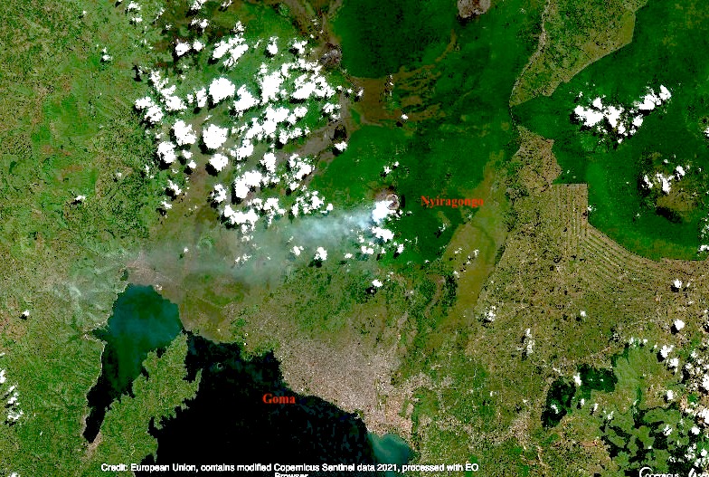
Few people would have heard of Mount Nyiragongo before its current eruption. There are some cities that we know live in the shadow of a volcano. Naples and Vesuvius, Catania and Etna, Seattle and Rainier (although the city itself is unlikely be affected by an eruption), Fuji and Tokyo (with the same proviso). But Nyiragongo is worse than any of these. It erupts often (the current eruption is number 35 since 1882). The effusive lava is very fluid and moves fast. Worse, the mountain is extremely steep for this type of eruptions, reaching 50 degrees near the summit. The lava flow can reach speeds approaching 100 km/h. And the city of Goma, with half a million people, lies directly in one of the paths the flows can take. Finally, this is in the DRC, perhaps the country worst equipped to deal with volcanic risks. Both the 1977 and 2002 flank eruptions had a significant number of fatalities in Goma. In 2002, 13% of the city was covered by 2-meter thick lava as it flowed towards Lake Kivu. And fatalities continued long after the eruption had ended.
Since 1970, there have been 25 volcanic eruptions worldwide with fatalities. By far the worst was Nevado del Ruiz, where 23,000 people died. Second is El Chichon, followed by Pinatubo, Anak Krakatau and Merapi. (In my opinion, Kazbek should be added to the list.) Nyiragonga was already the only volcano to appear in this list twice, with both appearances among the 10 worst eruptions of the past 50 years. And now it is in this list 3 times.
(The number of eruptions worldwide with fatalities has increased dramatically in recent years. Since 2010, there has been on average one such event per year. Before that it was much less. In two cases tourism was involved, but the others were people living in the wrong place. With volcanoes, precaution is the only effective strategy.)

People crossing the hot lava on foot, the day after the 2002 eruption. Many burn wounds resulted. Heavy rain a few weeks later caused dense fog and gas, which led to further fatalities. Luckily the 2021 eruption was in the dry season
We often discuss the dangers of explosive eruptions, and point at Krakatau, Tambora or El Chicohn. Those kinds of eruptions are huge, devastating, and unpredictable. Often the culprit was not recognized as dangerous prior to the explosion. Effusive eruptions are more sedate, tourist-friendly, and predictable but also more frequent. We acknowledge the damage they can still do, and the desperation of people seeing their home engulfed by lava. There is no such thing as a friendly volcano. But Goma finds itself in the worst of both worlds. Its mountain suffers frequent effusive eruptions which come fast and without warning, and are as deadly as explosive eruptions would be. And it is not only the lava. The gas emissions cause acid rain which can damage plant and tree growth on the mountain. Near the crater rim, underneath the volcanic plume, the rain can have pH as low as 2. Low pH and high fluoride has been measured as far as the village of Rusayo, 10 km from the summit.
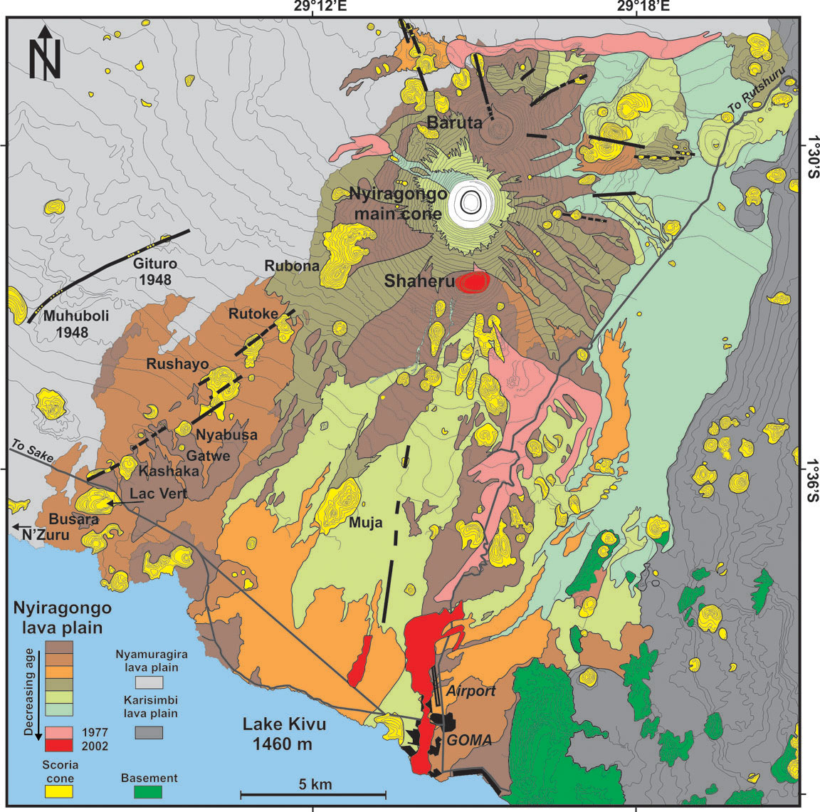
Geologically, Nyiragongo is part of a cluster of volcanoes, two of which remain active. Together they form the Virunga bulge, home of wonders including the impenetrable forest and its mountain gorillas. The bulge sits at the intersection of the Albertine rift (the western branch of the African rift, running north-south – the volcano, as well as Goma and Lake Kiva are located in the rift), and the Kamatemba rift (running northwest to southeast into the Albertine rift). Exactly what feeds the volcanoes is being studied, but a crossing of two rift indicates this is a weak spot. Two magma chambers are suspected, one shallow and one 14 km deep.
The unusual lava of Nyiragongo is attributed to a melting of a carbonated mantle. It differs from all other lavas in Virunga. This seems related to the depth: its magma formed from a much deeper melt than elsewhere in the Virungas. The lava is often claimed to have the lowest viscosity of any volcano known but this is disputed. It is fluid, but the extreme speed of the lava is caused mainly by the steepness of the cone.
The steep cone is not what one would expect from low viscosity lava. It should have build a very broad shield, not a cone. The mountain cannot have been build by these lava flows. There are several possibilities. There may have been a very recent change in the magma. But none of the lavas seen in this area can build such a steep cone. The second possibility is that the mountain was not build from the outside but from the inside. The mountain is in effect the sides of the conduit. Magma rises, forms a lava lake, and the lava lake solidifies against the sides and adds bulk to the mountain. The magma builds the mountain around it. Because this builds the mountain with solidified rather than liquid rock, it can be much steeper than flowing lava would allow. The lava lake has several benches: these benches are how the mountain grows.
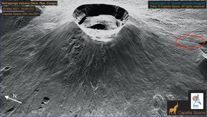
The 1.2-km wide, deep crater of Nyiragongo hosts the largest lava lake in the world, some 200 meters wide. The mountain is 3470 meters tall; the lava lake is typically at a height of 2700-3000 meters, while Lake Kivu is at 1470 meters. You can imagine the stress that the sides of the mountain are under! It carries a 1-km wide bucket of lava at the narrow tip of a steep cone. The sides of Nyiragongo are indeed riddled with rifts, many of which are unmapped because of the dense vegetation. These rifts can feed the eruptions, as they did in 1977 and 2002, and apparently also in 2021.

The volcano is about 12,000 years old; the current deep crater is though to have formed a few hundred years ago through caldera collapse. There have been previous collapses: there are two other but extinct craters of similar size, one located two kilometers north (Baruta: visible on the image) and one 2 kilometer south of the current crater (Shaheru). The three cratered cones are aligned: there seems to be a short north-south rift underneath Nyiragongo. This rift follows the direction of the Albertine rift and therefore may have benefited from spreading in the Albertine. In contrast, the Virunga volcanoes overall follow an east-west line. Although the parasitic cones are themselves extinct, they are not immune. During the 1977 eruption, lava erupted inside Shaheru crater.

The flows and source of the 2021 eruption. Click on the image for full resolution. Sentinel image from June 2020
The 1977 eruption formed a rift just above the Shaheru crater; lava flowed into this crater. The 2002 eruption showed lava fountaining above Shaheru from the same fracture. But the 2002 eruption extended this rift much further. The southern flank of Shaheru was ruptured in two places, 300 meters apart. The rift extended downward towards Goma, causing small grabens with lava fountains in several place along the way. These fissures reached the city itself.
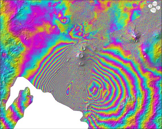
Capella radar image of Nyiragongo (https://twitter.com/RaphaelGrandin/status/1396948118067888128). The rift that was active in the 1977 and 2002 eruptions is indicated by the oval.
The 2021 eruption appeared to have started just southeast of the Shaheru crater, close to previous flows. The lava appear to have come through the same fissure as in 1977. The flow split in two, with the longest one heading south, ending within the Goma suburbs close to the airport runway. In the day after the eruption, Goma was hit by several earthquakes which caused cracks in roads. This seems to have extended the activity of 2002, when minor rifting and gas emission was seen 500 meters beyond the lava flows, as far as the airport. In 2021 it reached just off-shore into Lake Kivu. A long crack in the N2 road parallel to the coast also suggests some ground movement within the lake. The rift has thus progressed from 1997 when it formed as 2-kilometer long fracture, to 2002 when it extended by 15 kilometer, to 2021 when it added a further kilometer. Note that this does not mean it is exactly the same crack. Rifts have a certain width and the new crack may be next to and parallel to the previous one.
The eruptions are fed not from a magma chamber but from the existing lava lake. This means there is little or no tremor preceding the eruption as there is no rising magma. Instead, they start when the growing pressure of the lava lake breaks through the steep sides of the cone (a fate the Geldingadalir walls are trying to avoid), involving tectonic earthquakes. In 2002, the eruption was preceded by an M4 earthquake two weeks earlier. This earthquake may be when the break first began to form. The 2021 eruption did not have a clear precursor earthquake. (An earlier claim in this post for a precursor earthquake was based on an erroneous location.) The aftermath is also the same. In 2002 there was earthquake activity on a line between Goma and Nyiragongo for 5 days after the eruption, with the strongest even M5, and in 2021 there were several earthquakes in the day after the eruption also peaking at M5. This pattern adds some predictability to the Nyiragongo eruptions.
But this expanding rifting activity points to another major danger, beyond that of an eruption in the heart of the city. This mountain seems unstable. The rifts in the side are integral to the mountain (that can be seen because many of them directly feed volcanic gasses into the water system). There could be a failure where two of the side rifts combine and one side of the mountain slides down-hill. Such an event would be catastrophic. Most volcanoes in the Virungas show no evidence for a flank failure, but the extinct Mount Sabyinyo does have a big gap in its side and on satellite mages a 1-km wide crater, 2 km southeast of Mount Karimbi also seems to have a gap on the side facing away from Karimbi.
But let’s look at Goma itself. Why build a major city in a place where it has been hit by lava streams three times in the past 50 years?
Goma is at the border with Rwanda. Gisyeni, the part of Goma on the Rwandan side is well connected to the Rwandan capital, Kigali. Travel in the DRC can be more difficult. The area is very densely populated, fertile, with mild tropical climate. The Rwandan genocide in 1994 caused many refugees to flee to Goma, with rebel movements following. The area has remained rebellious and it is not always under control of the central government. People are attracted by the mineral wealth of the DRC. This should be a fabulously wealthy country. Instead, the wealth goes to however manages to profit most. Some of the rebels have a cause. Others just want the wealth for themselves. And earlier this year, the Italian ambassador (who also helped to run the world food program here) was killed by rebels, in a kidnap that went wrong.
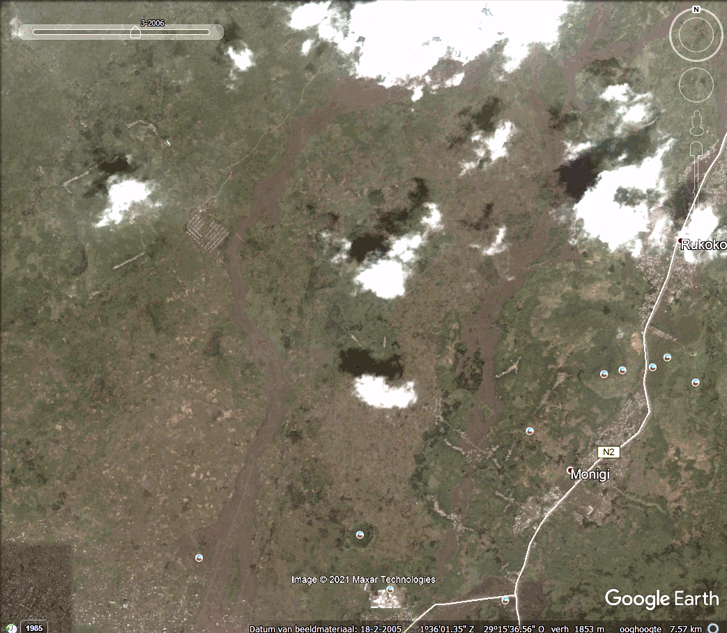
And in spite of the insecurity, Goma has grown rapidly. The current population is estimated at 670,000, growing at 5% per year. It is now three times the size it was during the devastating 2002 eruption, and ten times that during the 1977 eruption! New roads have been build (many by Chinese contractors), on top of the 2002 lava.
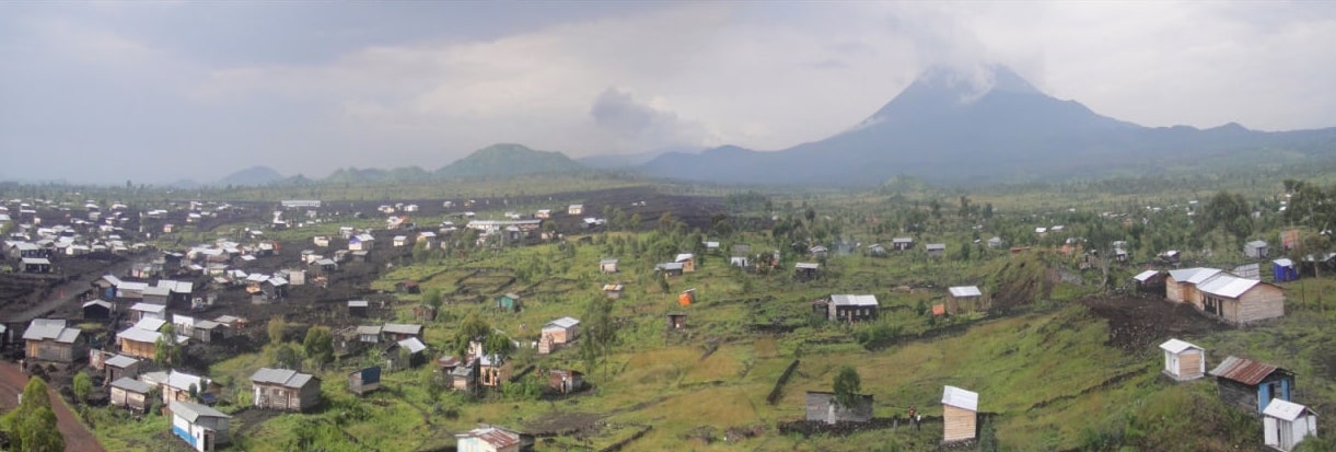
In view of such unstoppable growth, where do people live? They can’t go east, towards Rwanda, as Gisenyi is too small and itself has no room to expand. West gives some space but quickly takes them out of the rift valley. South lies the lake. So the city grows west along the lake shore, and north on the plains leading to the Virunga mountains. Much of the land is already taken, and so people build houses where they find unoccupied space. People have to get to work, using the taxis, any ride they can get, or by walking. So they live near the roads. Conveniently, there is space here which is not farmed or otherwise occupied. That is, they build their houses on top of the recent lava flows.
A time line shows the growth of Goma. The image below is from 2005, when the 2002 lava flows are still visible.

Goma, 2005
The most recent image, from 2019, shows dramatic changes.
Goma, 2019. Click on the image or here to see a timeline
Putting the Google earth images together (thanks Gijs, Lughduniense!) shows the rapid expansion in a time line of Goma’s growth towards Nyiaragongo..
As you can see, the expansion of the city follows the 2002 lava flows very well, along the roads build on those flows.
But the lava flowed along those paths for a reason. Nyiragongo can erupt in all directions, but in the three major eruptions of the past 50 years the lava has gone south, following the underlying north-south weakness in the mountain. This rift formed in 1977 eruption, was re-activated in 2002 and possibly again in 2021, extending through the city and now into the lake. The rift provides a pathway for the lava which inevitably ends up in the same area as before, following very similar flow paths towards the lowest points. The people are living on a ticking time bomb.
They do so not by choice, but because they too have to live. These are not refugee camps, put wherever others can’t see their plight. They need houses to live and places to work. They are people just like us.
And now Nyiragongo has erupted again. The precursors were too weak to be seen on the few available instruments and by the few scientists. Do not expect magma signals: the lava is already in situ and all it needs is to break through the crater wall. The precursor was probably a faint tectonic signal. People knew that a new eruption was imminent. The lava lake had grown too big. But they did not know when. Suddenly the sky went red and the lava came. Eruptions of Nyiragongo only last a few hours. By the time the alarm was raised and the evacuations had started, the lava was already among the people. We do not know yet how many casualties there were. So far, 500 houses are reported buried, 23 people died from the eruption and 9 from a big traffic accident in the evacuation. The real toll will be higher and may never be known.
Proposals have been made to safeguard Goma. Dams could be build to divert the lava around the most endangered area in east Goma. The problem is that this would divert the lava towards other areas that are just as densely populated. Warning systems have been proposed, already 25 years ago. But hardware on the ground does not last long, often due to theft. Before the 2002 eruption, only 2 of 5 installed seismographs were still working. The rangers who lead the expeditions to the lava lake do report anything unusual – but it needs people to collate and analyse the reports. The 2002 eruption has been predicted in advance by the local scientists, based on reports from the rangers and the little instruments they had. There was failure of action on these warning by the authorities – who in any case do not carry much authority here. The 2021 eruption was expected but was not predicted.
What can be done? Monitoring from space is difficult because of the near-perpetual cloud cover over the peaks. Seismographs could be placed in Rwanda, not many kilometers away. But that is a different country and they cannot issue warnings for Goma. With such a volcano, an eruption warning needs to be instantaneous (in 2002 lava reached Goma within 20 minutes, and because the rifts extends into the city the eruption could in theory begin within the city limits), and should be unmissable. It can be done – even here, most people have mobile phones. Pre-eruption warnings need to be accurate, otherwise they will quickly be ignored. That requires significant scientific effort. And finally, we need predictions where lava is most likely to flow, and discourage people from living there. East Goma in particular should not be there. That may be the hardest task of all.
Goma was lucky this time. But there will be a next time. And one after that. And one day this could become the Pompeii of the tropics.
Albert, May 2021
Addendum 27 May 2021
A new INSAR image has appeared show ing spectacular changes in the rift valley. The image shows the changes between 19 and 25 May (i.e. including the eruption but not the subsequent tectonic activity). It is reproduced here (at reduced resolution), with the original taken from https://pbs.twimg.com/media/E2U9GXEWEAU55XF. The INSAR data is also available from https://sarviews-hazards.alaska.edu/Event/221?pinned=d989972a-8f8e-4337-9744-f9dbb668ef33,406295fb-403e-4604-acc9-4cd65ddeae09
Sentinel INSAR data, 19-25 May 2021
This looks very much like a dike intrusion but there are two aspects worth noticing. First, the coloured contours are best visible along the side of the rift valley. Second, the colour sequence on the left and the right of the valley are reversed (look for the order yellow-green). It is always hard to separate up/down from left/right in these plots (the satellite measures the distance from the satellite to the ground, and if it is not directly overhead it will see both). The reversal suggests that the sides of the rift valley are moving away (or towards) from each other, i.e. rifting. If they were moving up (or down) you would see the same pattern on both sides.
So there is rifting. But there is not much indication for a large dike. That would show up as inflation in the centre and that is not really seen. (Unless it is localized in the feature near the lake coast which coincides with a ridge in the landscape).
We will wait for more data. I think there is rifting between Shaheru and Goma. Whether there is lava inside the rift remains to be seen.


I guess if push comes to shove!
Have the lava blocks overtopped the wall?
https://drive.google.com/file/d/1xQTvCBXu-WN3Axs3bwAPgxJgFmHENKxG/view?usp=sharing
As far as I can see, lava bit’s have broken over the barrier crest,but not a flow over the crest!
What I said, “the lava blocks have overtopped the wall”.
The col has been advancing slowly in the last hour.
Also someone examined the wall earlier on, hopefully Gutn Tog (presumably ‘good morning/day’ in icelandic.)
i think so
A few minor spills; but nothing reaching further than the base of the wall. The lower portion of the track is buried; but it looks like the tongue of lava that did that gas about 10 meters left to travel before it poses a serious threat to the wall.
…has about 10 meters…
http://www.virunga-volcanoes.org/
Fantastic site on Virungas Volcanoes
Perhaps useful for Albert in next article
Chose volcano in the menu bar.. tons of information on Nyiragongo and Nyiramuragira
Jesper hey -good find,thanks!
Another good video… showing how low Nyiragongos viscosity is
The fountains is Nyiragongos lava lake are often much much smaller than in other normal basaltic lakes.. perhaps because Nyiragongo lacks a gas trapping lid layer. Nyiragongo is also much darker colored in daylight so its alot cooler…makes alot of sense when its so superalkaline.
Halemaumau looked like this… when it was disturbed by a rockfall
Nice footage here. Cue panicking drone trying to escape being frazzled!
https://twitter.com/Sjonni_KAUST/status/1399279040440246274?s=19
And that video also explains (to me, at least) the white-looking surface on the cone these days.
Not really white, but a coating of glassy, shiny, highly reflective lava. That will look white, and especially under an overcast sky.
are you sure it is not melted drones?
Yes thousands of these have sourely been incenirated there
They loves their cooked boiled drones Icelanders
Wouldn’t it be possible to divert more of the lava into Meradalir with a few well placed explosives, to dig out a channel? I’m sure the US Air Force has some spare ‘bunker-busters’ – pretty accurate and designed for penetrating reinforced concrete they should make short work of lava.
Has this been tried anywhere in the world? What diversion techniques are available other than sea-water as on Haimaey in 1973?
Yes, was attempted in Hawaii in 1935 and 1942 both times were total failures, all reports of success are before 1984 when Mauna Loa erupted in the same place and behaved exactly the same without any attempts to stop it. Kapoho in 1960 was flooded by lava, there were many dams built and the lava shoved them aside with little effort.
It really was well accepted that with this eruption likely to last a long time lava would bury these areas. Thing is it was not forecast that the eruption would actually increase with time, which it seems to be doing. There is some similarity to Nishinoshima, that was a bit more viscous and evolved (hot andesite) but it likewise started very small and became a real monster in its final days.
Mauna Loa was about using explosives to block lava tubes. It worked but made no difference. We should be able to do better now but it has one major flaw: it makes you responsible for damage done by lava in its new flow path. HVO decided that was a risk too far. The walls have done amazingly well in containing the flow, temporarily. I had expected the weight of the lava to break through but that has not happened. Instead they are overtopped. They have been a good delaying tactic. I do wonder about after the eruption, when you end up with a wall holding back a rockfall. If rain erodes the wall, i would not want to be anywhere below it.
“it makes you responsible for damage done by lava in its new flow path”
Even in Iceland? I can see in the US lawyers would try that, I thought the Icelanders were more pragmatic/sensible/solidarity/communal spirit.
Meradalir looks pretty empty, surely better to try? On the other hand if the eruption continues long term it would just be postponing the inevitable – but in that borrowed time may more (vaccinated) tourists would come.
If you look at the Meradalir camera, there’s been plenty of lava going there for the last few days; enough to make me wonder if the walls are actually having a slight affect by ‘backing up’ the lava, and causing breakouts to go another way.
If all that lava had headed south, we might be focussing on the road by now.
https://www.youtube.com/watch?v=8Gx7yKhY3II
The huge lava river from the cone… seems also be splashing into a lava tube…
it no longer feeds an open lava pond… getting more and more tube feed.
The eruption keeeps going at same intensity
I have a question. No worries, very easy. I just read that your blog was stolen once. In the comment section everybody sends Birthday greetings to you. June 6th.
I started reading here more when that new Icelandic volcano was born, and that was around your birthday.
I find that more difficult than some of the tectonics stuff. Is that a birthday propagation?
It should be noted that in Hawaii these sorts of rootless shields abd lava lakes would sometimes break to release a lava flood that sometimes would move several km in a few hours, that is the risk of the Natthagi lava dam collapsing, all that lava behind it will rush out.
https://earthice.hi.is/eyjafjallajokull_2010_chemical_composition
lava composition evolution….if someone can comment what it shows…
Fimmvörduhals was a low silllica cold visocus alkaline basalt 47% sillica and likley very similar to Etna lavas in composition
If ‘Theatre Hill’ does get closed, it would make a great place for a camera, maybe we could finally get some shots of how the lava outlet bends around. Maybe RUV could be persuaded to move their Geldingadalir cam onto the hill.
Just watching the eruptions, it looks at present as if the lava flow splits 2/1 west (behind Theatre Hill)/east. No wonder the level is so high on the left (west) side of the saddle. In hindsight the saddle might have made a good place for another wall.
Does anyone know what the current Icelandic mitigation strategy might be? Other than hoping it stops? I can see a way round the comms cables issue (burial maybe in concrete tubes) but I’m not sure I’d fancy driving over a bridge with lava flowing underneath.
Driving over a bridge over lava? Generally probably little more of a hazard than over a dry ravine or even water. Either which way the chance of any problem at all is minuscule to start with and a higher chance of death from a very very low risk activity is still a very low risk.
Probably more dangerous to go down a set of stairs.
You may be right, I’m tending to assume the bridge supports will also have lava flowing round them and have no idea what that might do to the structure. Are there precedents in say Hawaii?
Latest I read was that the fiber optic cables were being reburied at twice the depth in a more heat resistant plastic tubes. The experiment at the Easter Wall, where they buried a fiber optic cable at the same depth as standard on the lava side of the wall, has shown that the fiber optics will still work even if buried and heated up by lava.
As for if any more and then where further earthworks will be attempted, is under review and decisions will be drafted/made towards the latter end of this week
The fibers are under lava already and still working.
The experiment is over!
Another electronic device killed by Icelandic lava.
https://www.mila.is/um-milu/frettasafn/ljosleidari-undir-hrauni-nidurstodur-profunar
Beautyful pahoehoe lava! and fine ropes too…small textures… a sign that the fagradalshraun lavas are really fluid and low in viscosity… near the vent it flows like a flash flood
Vehicles at the east wall, presumably getting an idea of the fate of the west wall – they earlier took a good look at the right hand side of the west wall where overtopping seems most likely, maybe a bit already.
The volcano looks magnificently threatening – easily higher than Theatre Hill, surely? Still vast quantities of lava heading west, it’s raining, steam everywhere, the vehicles are retreating to relative safety. Wonderful to see from a sunny England – most grateful to all those who enable us to see such sights, and to those here who lend us their knowledge and insights.
The volume seems to have picked up a bit. I’ve noticed it has lulls and surges. Last night’s overflow corresponds to a surge.
I think we are actually moving towards a shield volcano – the initial lavafall in the outlet has been replaced with ‘lava rapids’ and they are gradually building in height. In the next couple of weeks we may have a much more circular cone and the lava could be exiting 360 degrees.
I’ve been calling it a lava cascade.
There’s a National Trust property called Shefffield Park Gardens, about 15 minutes drive away, designed by Capability Brown, with 4 artificial lakes divided by cascades. Unfortunately I can’t find a video of the main naturalistic cascades working, so the more geometric Woman’s Way Pond cascade will have to do. It’s going full pelt at about 3 minutes 30 seconds from the start.
https://www.youtube.com/watch?v=ZjtF9SNbJrc
For cricket fans, the ground within the gardens is the site of the first England-Australia match, testing the teams agains each other. It’s also a stone’s throw away from the internationally famous Bluebell Railway.
Much of the lava has been flowing in Meradalir past days I think. The lava field is expanding that much, the eastern half of the valley (about same altitude) is going to be covered too.
Zoomed creen shot of the meradalahnukurSSV cam.
Altitude map of the Meradalir (vefsja.is).
The left (west)half is covered with lava yet.
It’s the other way round, Jesper, the smooth pahoehoe has flowed around the existing thickened a a lava in the last 3-4 days and nights.
Dark Aa rubbly unreflective lava flowscreeping over smooth grey shiney pahoehoes
2021-05-31: Current earthquake (seismicity) and ground deformation data continue to indicate the presence of magma under the urban area of Goma with an extension under Lake Kivu. Although there are still earthquakes recorded, their energy is globally lower. Their location and the direction of the GPS displacements still indicate a halt or pause in the propagation of the magma intrusion towards the south. A decrease in displacement velocities measured by the GPS network still seems to confirm these observations. The physical impossibility of installing seismic or GPS stations in the lake makes it impossible to accurately detect any upwelling of magma under the lake.
https://georiska.africamuseum.be/en/news/nyiragongo_eruption
Jesper, I was lucky enough to receive a few pictures of the fissures on Mt Niyragongo. You are absolutely correct, the lava flowed out like water from the fissures, almost no effect on the uphill side aside from some radiant heat damage while the downhill side is coated like a large tin of grey paint has been splashed across the countryside. The fissures are narrow with almost no splatter and remain sharp edges. Unfortunately I cannot post them here but they are available on Face Book.
Can you give me the Facebook link?
This is Nephelinite lava .. so its extraodinary low in sillicon dioxide
Nyiragongo have very low viscosity
( maybe ) lower than most Hawaiian lavas.. even If Halema’uma’u is Probaly just as runny
Sorry, dont have the link but did copy the pictures, can email them to you.
Yes do that
I wants to see.. you can get my email by asking VC dragons over mail I think : )
Wants to see them
Lava behaviour is fun and specialy with superalkaline magmas like these
In 1977 and 2002 upper fissures it indeed became like grey paint covering everything.. twigs .. elephants turtles .. everything covered in a thin layer of Nephelinite lava
Maybe the most visually stunning lava plume just now per the VISIR cam (~ 14:20 UTC)
https://www.visir.is/g/20212108673d/bein-utsending-eldgosid-i-geldingadolum
The rim in the foreground is getting topped in form of a massive cascade of lava, and this last one was simply jaw-dropping. Interesting to note that it took less than a minute (more like 30 seconds) for the new lava layer to turn glassy white…virtually instantaneous.
Looking at a couple of fountaining events here, I’m wondering if the length of time the lava spends being churned up as it is descending the cascade aids the release of gases, and helps make the lava more fluid and easier to flow further?
Image outlines extent of flows in Meradalir compared to a week ago. Besides the new silvery flows, the black area has been lifted up from below looking at the height on the far side. Thus the flow leaking out the side on the far left, which looks small, but comparing to fan map is a 600-foot advance. Also the increase in Geldingadalir threatening to cut off Lookout Hill. Would guess the flow rate this past week has gone up to well in excess of 10 m/s.
https://imgur.com/a/IBmpWog
more Sentinel 1 from Rwanda
https://twitter.com/j_p_joule/status/1399719069369184264?s=20
Post-eruptive deformation at #Nyiragongo (#Sentinel1 images – May 25 – 31). The intrusion moves south under the Kivu Lake. This is consistent with the observed seismicity and GNSS data (https://georiska.africamuseum.be/en/nyiragongo_eruption/20210531). Even the path of the lava flow is quite evident.
more of Sentinel 1. The collapse on main crater is quite impressive.
https://twitter.com/MountsSystem/status/1399490652983988226?s=20
Looks like the 2003 – 2021 crater lava lake overflow fillings are gone and collapsed into the depths …
As well as the 2016 – 2021 spatter cone vent in the caldera wall
Albert commented earlier how well the walls have done in containing the flow, temporarily.
I was wondering if pressure + heat treatment could have contributed to strengthening the wall?
Are there known mechanisms for that?
I think they were counting on the lava solidifying against the wall
https://www.youtube.com/watch?v=BA-9QzIcr3c
Around 15:22 pm, I noticed a tendril of steam coming from the very top of the active cone, while it was not erupting, is this from the snowfall on the cone? About the same time a large helicopter took at least 2 loops around the cone too.
Looks like a crack, and it looks like there may be a big splash coming very soon. The past half hour that section has been sagging slowly into the crater.
I couldn’t rewind as far back, but at 16.54 there’s a fair sized Puffing Billy going on. Perhaps a cone collapse is imminent.
Here’s a nice video that shows the surroundings and setting of the fagradsgsfjäll eruption.
https://youtu.be/iwBngnUlrpo
He also speaks of a official start to the reykanes cycle. Does anyone have the source of that?
I quoted one about three weeks ago. Maybe the Dragons can spot it in a search? I didn’t keep it handy on my PC. Google Scholar is useful for peer reviewed science papers.
The nub of it is the cycle starts very approximately every 1000 years and the peak of activity lasts around 200 years. The last peak ending around 800 years ago. Like all cycles, once identified, the wheels fall off… 🙂
Ah – here it is, 2nd May. I quote myself:
“If I may offer some research that might explain what I am blabbering on about:
Sayfried, R. & Freundt, A. (2000) Experiments on conduit flow and eruption behavior of basaltic volcanic eruptions. Journal of Geophysical Research, 105(B10) 23-
https://agupubs.onlinelibrary.wiley.com/doi/pdf/10.1029/2000JB900096 “
Sorry, wrong paper. Post was 28 April. here’s the reading (specifically Gee):
Refs:
* Gee, M.A.M. et al, (1998) Crustal Processes: Major Controls on Reykjanes Peninsula Lava Chemistry, SW Iceland. Journal of Petrology, 39(5),
** Schipper, I.C. (2015) The Surtsey Magma Series. Scientific Reports, 5.
Oh, the reykanes cycle has been described in detail here. I was thinking of whwt the narrator said on the video that the scientists had been reluctant to say the active part of the cycle had started, but that they now deemed it a fact.
That’s the gist of the video, that they’re now starting all sorts of preparations for the entire peninsula.
Two more timelapses.
From the mbl overview cam https://youtu.be/l7ssfaqKfp0
and the Ruv cam with the view from https://youtu.be/YIEdA8YBaXA.
Both from yesterday evening to this morning.
i find Your timelapses most enjoyable. Thanks! Best!mots
Wonderful. On the second, the lava quite often stayed red up to the next fountaining. There was also a notable breakout along the viewing hill around 5am until the video end. This resurfaced most of that back area.
I suppose it won’t be long before the fissure 1 cones are submerged in the sea of rock. I didn’t ever expect to see them disappear so soon.
Has Grimsvotn erupted yet?
Nooo not yet… but next eruption maybe sizable after increased magma accumulation after 2011
There was a 6.1 quake in Alaska yesterday. Seems like mostly road damage.
Time to read the excellent series about the Wrangell mountains again.
Ah – the million years of rain. I remember it well.
A million years? Goodness Albert, I would have put you a tad younger.
I do so love the Wrangells! Those unusual shield volcanoes (and some stratovolcanoes like Mt. Drum) there are very fascinating!
I forgot to mention what I meant by “unusual”. By this, Wrangell and several other shields in the Wrangell-St. Elias mountains are unusual in the sense that they’re mostly, if not entirely, made up of andesite and dacite. These types of volcanic rocks are of course usually found in steeper stratovolcanoes like those in the Aleutian arc and the Cascades, while shields are usually made of basaltic lavas.
Wrangell probably erupted its lavas via large Strombolian/Hawaiian-style lava fountaining, especially out of Mt. Zanetti. Zanetti is a very large cinder cone on Wrangell’s NW flank, and it’s probably as massive as Mt. St. Helens. It may be the source of some rather long (50+ km) andesitic flows on Mt. Wrangell’s flanks.
Mike K
If an Andesite emerge at 1100 C as some rare cases do.. it will be quite fluid.. fluid enough to make ”Viscous Strombolian activity”. that will make very large lava fountains like Mayon and big lava rivers of rubbly Aa. ”Viscous Andesite Lava fountains” must have been one of the tallest lava fountains on Earth.
That 50 km long Andesite flow must have been feed by a Hekla like fissure event on steroids
Most Andesites, Dacites and Ryholites emerge at relativt low temperatures at around 860 C and some as low as 700 C .. Thats one reason they are so viscous.. low temperatures makes sillica the sillica chain polymerisation very active.
The worlds hottest Andesite is erupted by West Mata Volcano that erupt Ultramafic high sillica Andesites at 1320 degrees C when submarines filmed that eruption it flowed like fluid basaltic pillow lavas and channels.
A Boninite eruption on land with same temperatures woud be as fluid as Fagradalshraun near very despite its 60% sillica. High temperatures breaks down the sillica polymerisation
https://www.youtube.com/watch?v=8Gx7yKhY3II
Another really good webcamera over fagradalshraun
From old archives showing how Nyiragongos lava lake looked like in 2005 – 2006
Nyiragongos lava lakes always haves a special apparence, with numerous crustal plates and small degassing.
These big bubbles are likley gas bubbles from the conduit. After 2007 the lava lakes gas bursts calmed and it became much rounder as well as enlarged…
http://www.decadevolcano.net/photos/nyiragongo_july06_01.htm
No visible surface activity in any valley right know. It could be that all the lava is flowing into Geldingadalir right now or is accumulating in the lava tubes somewhere else.
Nevermind just noticed the 2 active flows in M valley.
2021-06-01: Although earthquakes are still recorded, their energy is generally lower. However, there is some earthquake activity, mostly unfeelable, occurring southwards under Lake Kivu. The GPS network continues to show a decrease in displacement speeds measured at the stations. The physical impossibility of installing seismic or GPS stations in the lake makes it impossible to accurately detect a possible upwelling of magma under the lake. This decrease in energy released by the earthquakes, as well as in the GPS speeds, cannot yet be interpreted as indicating the cessation of volcanic activity. During phases of volcanic activity, periods of higher activity often alternate with phases of lower activity.
https://georiska.africamuseum.be/en/news/nyiragongo_eruption
Gutn Tog’s latest video is rather like an “apocalypse” video, at least in the first three minutes!
https://www.youtube.com/watch?v=dkc7f95KfZs
Enjoy!
I’m sure I heard him swearing under his breath. 😂😂
I like how this guy is becoming a volcano celebrity ^^ He should keep it up, maybe opening a Patreon for financing, and try and do the same with other volcanoes if the Patreon takes off.
I’m catching up with the Langihryggur webcam. About 18.30ish, there’s a fixed wing plane flying low. New data for a 3D model?
That lava tongue seems to have stopped since the SAR closed the hill.
Areal overview from the whole lava field on June 1st. Not from a whimpy drone, but a real aircraft.
The “pool” of lava collecting at the neck sometimes gets extremely steamy in a matter of seconds (06:05:55). I wonder what’s causing this? A sign of increased acitivity, a kind of heaving of the molten lava onder the crust?
I think it is cold air being pulled in. The hot air above the lava rises, and airs comes in to replace it. If this comes from inside the lava field, nothing happens, if it comes from outside it is much colder and the vapour immediately condenses.
I went back to have a closer look as I was not convinced.
Rising vapor plumes in the vicinity show no indication of change in wind direction.
Vapor rises very sudden and quite violently straight up from the whole area of the “pool”. Doesn’t seem consistent with inrush of cold air. More like it’s set of by a tremor or vibration.
There are probably different causes in different places. You can get it from water below the surface which escapes, forming a geyser. I think that happens in the location where there are continuous plumes. There is one near the eastern wall which on one of the videos appeared to be from a pushed up heap of soil below the lava surface. Often the steam is at the edges of the lava fields. In those cases it is likely colder air. When it is the entire lava field instantaneously steams, it can’t be geysering as that would be different everywhere, and it can only be a drop in temperature. If there is steam going up everywhere, there must be air coming in to replace the rising air. When it is seen above lava that was just expelled, then water within the lava is a real possibility. Pick your choice.
Rain water turning to steam / water vapour. It had been raining heavily a few moments earlier.
Yeah, but why this “pulsing” pattern?
Some new information about Kilauea released today, the eruption of 2020-2021 at this point filled in about 5% of the 2018 collapse volume, or about 1% a month. At that rate it will take about 8 years to fill the 2018 caldera if summit activity stays dominant. The chances are though that it will take less, and fill up a lot quicker, but also collapse again before filling completely.
The GPS and tilt are looking increasingly like a new eruption is imminent, I would expect a resumption at the existing vent but as we saw last year timescales are on the order of less than an hour with eruptions here so anything is possible. Best guess at this point is in July or August there will be another eruption.
Indeed, the tilt shows some strong and increasing inflation during the later part of May. Nine microradians of inflation this last month is close to the highest rates of inflation seen in the last years. There are no pressurization ground-cracking swarms yet though, perhaps because the pressure Kilauea reached in December has still not been exceeded.
Been wondering, if Kilauea remains long term quiet-will the lava lake become rock hard (over long period) or will it remain mushy warm ?
As a rough number, it takes a week for 1 meter thick lava to solidify. This lake is 200 meters thick, so it could take 40 years! Not quite as long in reality because it is a cone rather than a cylinder. But we are talking decades.
I should add that this assumes rock. If water circulated through the lake, then it will cool down faster. Water is a very efficient coolant, even for lava. But Kilauea does not have much hydrothermal activity.
Thanks Albert, good I can stop wondering on that!
I assume Albert hasn’t just multiplied 200 by seven days because that’s only about 4 years.I cannot be bothered to work it out from first principles but typically as each meter sets it insulates the next layer, doubling the solidification time so I would expect it to be exponential to first order. Hmm that comes out to way too much!
Hmm. Yes, this was off by a factor of 10. The problem is that if you know the right answer, you don’t ‘see’ error that give you the expected number. The speed of solidification is not a linear function but a square root: it slows down with time. I knew it had to be somewhere around 50 years. Doing the correct calculation for 200 meters thickness gives me 66 years. If I only need 100 meters (because of the cone shape) it goes down to 17 years. Earlier pit craters on Hawai’i solidified down to 16 meters depth over 4 years, so that speed agrees well. The first meter solidifies much faster, of course
I’m probably doing the wrong Maths here: 1 metre one week would mean 52 m one year. So not 40, but four years. Right or wrong?
You are the second person to point that out. The number is right, the math was wrong. The thickness of the solidified layer increases with the square root of time. It is not linear. All three previous well-studied pit craters/lava lakes around Kilauea took around 4 years to solidify to 16 meters depth.
Without water circulation it will cool much slower than that…
Will take a few 100 s of years to cool below the lowest mineral melting points
This lake is deeper than Iki.
But this lake will be destroyed or reerupted already next year…
Kilauea haves an insane magma supply… the largest single supply for any known individual volcano on the planet. For now Kilauea cannot be quiet for more than a year perhaps.. or erupt constantly….
A true open conduit lava lake.. may also form like Nyiragongo in 2003 if Halemaumau keeps swelling like this constantly.. that will start with a large fountain
Try next week Jesper, have a look at the deformation and quake data… 🙂
Will take over 100 years for the middle of it to cool down to solid, so yes in theory but in practice this will never happen, not where it is. 2018 flows though are of similar thickness in places and likely will be left alone that long.
It crystallizes from the walls, the interior part of the lake remains hot and molten until it shrinks to nothing. This has been observed in other ponded lava lakes.
Yes, if you go back to last month quakes it is looking on that track though, and at the rate things are going with the deformation it will reach December levels before July, probably even in just a week or two.
I am increasingly inclined to go with the idea that the last eruption basically ended after a week and that the only reason it went on so long is because there was a still active vent above the lake that was able to leak some lava while the pressure recovered. The SO2 has been declining and the deformation showing inflation all year and with no deviation, only thing is that there was still lava leaking out, It is looking like Kilauea will be back to its usual very active self from now on, incredible really considering eruptions of the magnitude of 2018 are typically terminator events that send their volcano into deep sleep, Kilauea is really a beast.
The excess pressure that Kilauea had relative to the height of Halema’uma’u crater was released in a week, the rest of the eruption kept erupting the supply as it came into the volcano, in an open behaviour like Pu’u’o’o, there was also some magma that remained underground and inflated the magma chamber perhaps to support the rising magma column or for some other reason.
It took 5 month to fill 1% of the hole left by the Leilani eruption. We can call this a trickle… The activity declined to effectively zero in mid April, so I would put the end of the eruption at that point. The current tilt acceleration is interesting. It does not yet show up much in the inflation. UWEV is flat, but CRIM shows some small uplift over the past weeks. This suggests the area that causes the change in tilt is small, and located in the southern part of the caldera, i.e. the feeder system of the past eruption. The speed of the change also suggests it is caused by shallow magma, no more than 1 km below the surface. The amount of magma involved in this may be quite small.
HVO has the end date of the eruption on May 12, that is when they think the vent actually stopped as the lake stopped rising. About half to maybe 60% of the eruption was in that first week too, that is a bit more than a trickle I think.
It remains to be seen how high the supply to Kilauea is right now but it is elevated and has not declined after 2018 as some speculated. Mauna Loa has been getting more attention but even in 2015 it was only 10% of the supply that Kilauea was getting. We didnt see that though because Pu’u O’o was a pressure release valve, and up to December last year there was also rift filling to do following 2018. But now it seems we can observe the supply in full and what it can do, hence the rapid deformation. If there isnt another eruption this month then it is going to be very impressive when things break.
UWEV should start showing the inflation soon, the tiltmeter is where UWEV is but the GPS are always slower to show trends than tiltmeters. I think that HVO’s GPS graphs take a few days to show the data points.
The supply to Kilauea after 2018 has fluctuated a lot. Influx during 2019 produced the average inflation rate of Kilauea’s summit during dormancy periods, and adding the ERZ inflation then it may have been a bit higher than average. Influx during 2020 clearly dropped to low levels that I think are well below average. The year however ended with the spectacular surge of December that triggered 2 dyke intrusions and possibly one sill intrusion.
In April 2021 the supply dropped to almost nothing, inflation was paused in the Halema’uma’u and south caldera areas, and the lava lake barely rose at all. Now, judging from the tilt, it looks like the supply is accelerating and has already reached average or slightly above average levels.
The supply from the mantle seems to vary by about a factor of 2 over years. The supply to the summit can be much more variable, as there are various storage chambers on the way. What we are seeing now is the supply from a storage chamber to the shallow reservoir. It may even be inflation of the dike that fed the 2020 eruption. Let’s see how this pans out.
Kilauea inflation is skyrocketing right now, we might be in for another magma supply surge like that of December.
Ring fault curtain of fire lava flood inbound… 🙂
Probably not, I would guess the same vent as before will erupt, but it will be very different than in December because the lava will cover the vent immediately in this case, or erupt under the lava lake. That is the sort of thing that would induce a rift eruption, a summit eruption that is choked in stage 1, which didnt happen in December but did happen in all the 20th century eruptions after 1950.
Alternative is a Kilauea Iki 2,
Helicopters are landing on Spectators Hill, guess that is the new way of getting there now
It left without taking its passengers with it 😀
One way Taxi service 😀
It seemed to be blowing a lot of smoke from the engine as it left (@ 09.35), Bit of a worry if that was not an illusion.
It made it back again 😀
Should park it there until an outbreak claims the neck, and then see what that does to the transport rates to get back out 😀
They heard you; there are 2 there now 😀
Am hoping they were installing a new camera. There appears to be something new, unless they forgot someone!
Nyiragongo now visible on Sentinel radars
Its a huge hole .. in the crater bottom Thats deeply collapsed …
But it will be very difficult to kill off the lava lake conduit for years, I think the lava lake may return very soon?
In 2002 that was maybe a deeper drainout than This one.. the lava lake returned in as soon as 2003 as lava rised in Nyiragongos conduit
But after 1977 it was No true open lava lake activity until 2003. The whole 1980 s and 1994 – 1977. It was just small dyke eruptions in the crater forming temporary lava pools.
If we are unlucky.. then Nyiragongos lake will be gone now for 20 years
WTF.. my gmail and NOT my face 😞
”comment avaiting moderation”
Somekind of Bug perhaps
You might find an empty packet of biscuits in the dungeon!
This happened to me recently. I probably mistyped my e-mail address.
The saddle near the dam does not appear to be in any danger of going under for a few days. If at all.
The reason for my claim is because I believe the flow into Geldingadalur has markedly decreased.
Up until a few days ago, the vent had a high-lipped exit into the valley. But that has now been lost due to the vent walls building up. No doubt some supply will reach Geldingadalur, but it may be a fraction of what it was before.
Of course, now that I have written this, there will be a lava wave that floods the saddle in the next 10 minutes…
What seems to have been happening throughout is that there is some ‘preferred’ direction and whilst flows that way are maintained at a decent level that direction persists whilst building a raised levee-bordered ‘river’. At some point the flow slows, often due to self made lava dams or local geography and the levee’s are breached allowing a fast flow down and producing an new preferred direction. This is also affected by the lava effective slope, which seems to require a degree or so of slope to maintain flow.
So I would not be surprised it the flow returns to the west in a few days/a week’s time.
Assuming emission rates remain high, and I get the feel that its slackening off somewhat.
While we weren’t looking, and only barely visible on the camera, in the last 24 hours the Meradalir flow has overrun the second part of that valley. Soon it will have to decide whether to go north or south
The valley widens with height so even a small rise now needs a larger volume of lava.
Yes, I csecond Farmeroz. Micro-topography and random factors such as wind direction at work.
Two helicopters on “Theatre Hill,” now. Perhaps we should call it “Chopper Hill”?
It’s now a helicopter taxi rank 😂
Heliport Hill, certainly.
People are now walking onto it in larger numbers. 😮
It is considered relatively safe at the moment or are they just chancing it?
Choppers are obviously practicing for the extraction of stranded tourists. Tickets are probably not going to be cheap.
Any ideas anyone on why the new lava is so much lighter in colour than the old black stuff?
Thats because its very fluid and chills to a grey shiney pahoehoe skinn .. just like in Hawaii .. smooth surfaces reflect more light than rubbly
I notice that this low-viscosity lava seems to cool and solidify very quickly – when a big fountain goes over the cone it solidifies almost at once rather than dripping off into the stream heading west.
Could this be a hopeful sign for the Icelandic authorities, if it just builds a shield round the volcano rather than sending lava to the coast road?
For short flows yes but longer flows will make tubes which will have the opposite effect. A tube fed flow here will reach the ocean, in fact provided the slope is in the right direction a tube fed flow will easily reach Grindavik, it will just be slow, but there is no question of whether it is possible. Look at Pu’u O’o sending tube fed flows as far as 25 km on only 1/3 the effusion rate of Fagradalshraun.
Have they done a close-up of the saddle recently on https://www.youtube.com/watch?v=BA-9QzIcr3c ?
Lava seems to be creeping forward but it is difficult to gauge with the current resolution.
Lava going out of camera soon, in meradalir.
http://brunnur.vedur.is/myndir/listi/webcam_meradalahnukurSSV.html
We need a new one 🙂
https://www.youtube.com/watch?v=xx6IOCC1n2Y&t=1925s
Maurice and Katia Krafftts visit to Nyiragongo in 1973
Here the lava lake is so fluid it looks like a pot of liquid iron bubbling.
But it was Hauron Tazieff that first recorded videos from Nyiragongos crater in 1960 s
Watch 27:24 – 29:13
https://www.ina.fr/contenus-editoriaux/articles-editoriaux/voyage-au-centre-du-nyiragongo-avec-haroun-tazieff/
Nyiragongo in 1948 video
This is really good. Thanks.
Courageous men to climb down there. As to Tazieff he shouldn’t have suffered from the gas dying at 84 years. Interesting: His father a Muslim probably from Crimea (Tatar), his Chemist mother Jewish from Poland, different times it seems. He was also with the first team exploring the La Verna cave in the western Pyrenées, a remnant from the Cretacious. He watched a cable break and Marcel Loubens die, so he knew about pitfalls.
Thank you Jesper, very interesting, admirable man.
Tazieff loved Nyiragongo and Etna and was close friend with Maurice and Katia Krafft
They are resposible for all the older videos recorded of Nyiragongos lava lakes ..
But the lava lake was seen from the rim much earlier by others in late 1800 s There is some crater Photos from 1890 of Nyiragongo
Tazieff was born in 1917… thats old enough to be in golden age of HVO geology
Tazieff grew up during the Frank Alvord Perret and Thomas Jaggar years…
But everyone that was born in the early 1950 s and 1950 s was born before Plate Tectonics where even known!
1914…. : ) even he died in 1998
Well, basically Alfred Wegener had an idea of plate tectonics, but he was ridiculized. Before he could prove some of it he died 1920 in an Arctic expedition, and then there was economical turmoil and then WWII. So e.th. became stalled although Harry H. Hess did some research during the war. Basically the research started agein in the sixties.
Amazing developments in 60 years, probably also due to interests and financing in oil-, gas-, uranium and mineral industries.
“How did Alfred Wegener attempt to find evidence for his theory?
Wegener gathered evidence in various fields: firstly in geophysics, then in geology and palaeontology. He systematically put together the arguments from these three main fields. That means he put all his efforts into collecting evidence for the accuracy of this theory. Together with his colleague Koch, he even carried out highly precise position measurements on the northeast coast of Greenland and then compared them with measurements of earlier expeditions. In this way he attempted to demonstrate a change in distance between Europe and Greenland. The values derived back then were at least one, sometimes two orders of magnitude too high, however. Initially the reference was to an annual drift on the range of 30 metres. That shrunk very quickly, however, to a figure of three metres. And today we know that in reality it was three centimetres at most.”
https://www.awi.de/en/ueber-uns/organisation/alfred-wegener/artikel/continental-drift.html
in English
Basically Wegener is the father of plate tectonics, but he died before being able to proof his ingenious thought.
Hauron Tazieff will always be acossiated with Nyiragongo… he was the first one to make films from the crater interior
Tazieffs first expedition was in 1948 … he vent there alot.. they where large scale expedtions with tons of materials, lasting many many weeks. Specialy in the 1960 s when he made the the film “devils blast” He also wrote a book on Nyiragongo. https://www.amazon.com/Nyiragongo-Forbidden-Volcano-Haroun-Tazieff/dp/081205296X
Haroun received a degree in agronomy in Gembloux in 1938, and another degree in geology at the University of Liège in 1944. In France he is one of these famous volcanologists togther with Maurice and Katira krafftt.
Another famous “man of Nyiragongo” is late french Jacques Durieux..
He died in 2008. Jacques Durieux been almost living at Nyiragongo since 1960 s and he became known as “bearded man from the volcano” by the locals. In 2003 Durieux fished for lava in the crater with long steel cable ropes with iron chain that was strecth across the crater. Durieuxs samples from Nyiragongo was analysed in Italy and no crystals where found at all… suggesting that 2003 lava lake birth was a completely fresh melt.
He also wrote a wonderful volcano photography book https://www.amazon.com/Volcanoes-Jacques-Durieux/dp/0810916991
Wait …Durieux died in June 2010 as correction
I was watching some random documentary where the volcanologists were fishing a lava lake with a hammer as bait.
I remember this book pretty well. The public library downtown in my city has had this exact same book in its shelves, and I used to read that book pretty often when I was younger during the pre-Internet days.
I get the impression the vent is going to enclose itself before long. The walls are rapidly thickening!
Either it will succeed in doing that, or we’ll have some interesting collapses to witness.
Hi all!
The “Lava Lake” at Fagradals volcano have been filled up again. Also it seems that the Volcano is getting more powerful but with shorter outbreaks.
I am a totally non-expert 🙂
Cheers Bonamici
Fagradalshraun now has several lakes and ponds. The original valley to the west of the eruption fissure line, which drained away so dramatically; the perched lava pond/channel into the MMBB or Valley of No Name, which itself drained and a small pond developed which seems to have become part of the cascade as a lava tube/sink has swallowed so much of the overflow; the pond in the Meradalir valley (was there ever a proper pond here, or was the lava just resting?); and the lake dammed up by the retaining walls the easern one of which has been overtopped.
Thanks Stars Die 🙂
Apparently Valley of No Name actually has a name, no-one bothered to check with the landowners. It is actually named Syðri-Meradalur or Southern-Maresdale, people got so used to calling it Namelessdale that they still use it on the news lol
@Christian Thordin
Don’t sweat the “non-expert” bit. All are welcome here. My only skill-set is that I have a knack for plotting stuff. Your opinion is just as valid as mine. 😀
I also think you are spot on in your observation. As for the longer duration between activities… that would allow pressure to build for longer and make the activity a bit more energetic with the longer wait times.
The ones to keep an eye on are Carl and Albert. Both have PhDs and are pretty on mark when it comes to evaluating what the geophysics have to say. As a rule, I generally defer to their opinion since it is far more empirical than mine.
(In the “real world” I’m a tech. My job is to make shit work even if it doesn’t want to) {Technically, a “customer engineer”, though no engineering degree is involved. (I’ve always puzzled over that one)} Either way, I have 40+ years experience in electronics ranging from analog and microwave to digital, so I’m no slouch. But I don’t sport a degree. Which is why I say you are just as qualified to state an opinion on the matter. As long as it’s not “moon-bat” you will catch no grief from me. As long as you follow Carl’s primary rule… Always “Be Nice“. It’s our guiding directive.
For all, my apologies for being verbose.
Side Note: I am scheduled to attend my 2nd cousin’s wedding next week. It’s been about 20 years since I have seen any of my cousins. Looking forward to it. The other Dragons of VolcanoCafe have sort of directed me to come up with an article from my endeavor. You see… there is an 81+myr old reef system in the area that I plan on looking at. My plan is to wander over and take a look at a surface manifestation of that reef near my Grandfather’s house. No promises… but I do intend on revisiting it. But I will be more wary of snakes this time. {Coral snake almost got me last time}
Anecdotally… I have been told that one of my cousins has experienced paranormal activity at my Granddad’s house. I’m not a follower of the topic, but I did offer to take my FLIR camera with me if they want to look into it. Who knows… it could get interesting. I have a @#$@ ton of dead relatives there. Pretty much everybody going back three generations. (and some of them didn’t get along.) {Except for one cousin that opted for cremation.}
… plus… I have to reinforce my claim for a burial plot next to my brother and sister. No… not weird. Just something that is important to me. I don’t fore see any urgency in using the spot… but it’s my parking space. 😀
Not that it really matters… we are ALL going to become part of the sediment of the Mississippi embayment.
i’ve missed Your ‘moonbat’ observations….. i for one will be buried at the end of a small town runway….. already got my plot. That way anyone visiting can wonder if they will survive the planes taking off over their heads. One should always contemplate their own demise when visiting the dead. 😉 Best!mots
My kids can do what they like with my remains, whatever is most convenient, I will be no longer need it. Quite like the idea of being composted though.
😎👍
Check Doctor Charles Balagizi FB
Nyiragongo have started to give off a normal looking plume again from the crater ..
Perhaps the lava lake have returned? difficult to say.. but perhaps not
https://twitter.com/simoncarn/status/1400146061856055301?s=20
A fairly clear #Sentinel2 overpass on June 1 detected a few localized SWIR hotspots (possibly hot gas vents) in #Nyiragongo’s crater after drainage of the #lava lake on May 22. A Sentinel-2 image from June 1, 2020 with the active lava lake is shown for comparison.
I don’t think it’s just my imagination, but it could be a trick of the light; it looks as if quite a lot more lava has tumbled over the western dam recently. No hint of any kind of flow, just things – falling over the edge, really.
There’s quite noticable glow in the fumes rising from behind the hill, as seen on the RUV Langihryggur camera.
Looks like there could be a sizeable breakout behind the southern end of the hill, possibly closing in on the saddle area.
Further west, so the saddle lives on for a while longer, it seems.
A lot of fresh lava behind the crater. But away from the wall now.
Many rivers in Meradalir.
Fagradalshraun is going to last for years.. Probably
But it would not surprise me at all If the crazy insanity of the stranded whale-porcupine-wankpuffin thats Dutchincense starts screaming out that this is the start of a New Siberian Traps or much worse😂
He is simply awful .. when Holuhraun was erupting .. he stormed Facebook with conspiracy theories.. he deleted geologically accurate comments from critics on his FB page and just kept pumping out crap…
He is doing this only for money from social media revenue
Luckly Facebook have now closed down all of Dutchincense s pages and clone pages .. not allowed on the network.
We can only hope that youtube does the same thing .. as well as twitch
People should be free to express their views/theories even when they are wrong and/or idiotic. A world where Big Tech are the censors is not the best world.
(I don’t know who Dutchincense is, never heard of him btw.)
It depends: if publications induces damage, censoring is allowed.
Depending on the type of damage and publication, it should be enforced or a warning should be added.
These are thin lines and difficult to judge but I think big tech really does it’s uttermost best to find the right balance to protect individuals where they can and still keep the masses correctly informed.
VC does have limits, and one of those is not causing people to panic. We prefer cool-headed science. That does not mean that we avoid disaster stories: there have been plenty of those in volcanic history, and many examples on VC. But Yellowstone really isn’t going to erupt. The bar, of course, has fewer limits, but even there we prefer to avoid panic. People are free to express views, but we are not obliged to be their communication channel. And our spam folder is chocker block full of comments (mainly by bots) that we will not publish.
Scientific publications are refereed, meaning unsupported claims are refused. VC is a bit happier to allow for speculation!
Our other limit involves respect for each other. Deliberate personal accusations are not allowed. But that was not your point.
Freedom of speech but not freedom from consequences.
Yes thats true .. free speech is very very important
But Dutchincense is totaly crazy.. but as you say just ignore him.. 👍
The Word ”Dutchincense”
I haves No idea what it even means 😂😂😂😂
https://www.youtube.com/watch?v=yi6RSz1Aob4&t=9s
Old tourist video from 1976 of Nyiragongo! the year before the lava lake drained
Unique home video also likley
If I’m not mistaken the saddle lava flow is slowly creaping forward.
I don’t see any “creeping”
The saddle section doesn’t degas anymore, so I think it is not active anymore.
Yesterday they allowed a lot of people to pass the saddle again.
But it will come back, at the moment the far north of Geldingadalir is getting a new layer of fresh lava.
when that is finished the activity might come back to the saddle region.
A new 3D model has been published. It looks like the farthest reaches of the lava river have become stranded and a new perched pond has formed closer to the outlet, this is probably the source of the current flows into Meradalir.
Link to the collection as the thumbnails give an interesting overview
https://sketchfab.com/natturufraedistofnun/collections/geldingadalir-volcanic-eruption
What that shows, is that the lava has reached the small ridge to the SE of Geldingadalur, so it needs to add depth to the laval field to escape. Also, it shows that it has to partially fill Natthagi to escape, as that is also uphill to the exit, once it reaches the mildy moist bit in the centre.
There has been quite a few earthquakes along the magma conduits at Kilauea, along with a very rapid inflation on the tiltmeter. There arent any really small quakes, but I dont know if that really matters too much.
The GPS did update too and it is mirroring the tilt showing accelerating and rapid expansion of the caldera, it is within the same figures as it was in December, within a few weeks of erupting, and also inflating faster than back then too.
Question is if this is a new eruption or the same as the one that was just called pau.
Along the southern rift there may actually be minor deflation. I seem to recall that the same happened in December (fact check required). The current tilt and GPS change is purely located within the caldera. It doesn’t seem related to the end of the 2020 eruption. Guessing [speculation alert], magma may be forming a new dike, different from the dike of the 2020 eruption. The ring fault around the collapse crater is of course always the prime suspect for a new exit. We may need to wait a few weeks before it becomes clearer.
The ring fault is where the first dike in December happened, which HVO thinks must have come very close to erupting after being able to observe the eruption a few weeks later, it might have stalled out only a few hundred meters down, the area was already a major solfataric field so would not visually show change. It is possibly only the fact Halemaumau was empty back then that stopped the eruption, but now it is half full in the vertical axis so a ring fault eruption is a real possibility.
The point that triggered the December eruption at this rate will be reached this week, we might not have much longer than that realistically.
Carefully watching active cone, at 9:30 am it went to fountain but could make it, so it bubbled for about 7 mins like hot water on the stove, then a big chunk of the cone fell into the pool stirring up a big brown smoke cloud. After that it tried another go around 9:45 am but not a true fountain event. Finally around 9:55 a weak fountain event occurred. There has been smoke coming off the top and much smoke is constantly coming from a location to the NNE
Seems like an interesting change of behavior
Same slow boil at 10:13am so the is a change in behavior. Could this be due to lower gas content?
Probably it is the amount of lava over the vent, it is behaving a lot like the way all the other vents did before only much bigger, a violent lava lake, either the vent us drowned or too wide to fountain as a tall jet, or both. This is probably a natural progression, it happened at Holuhraun and at a lot of other large lava flows in Iceland, and it also happened at Ahu’aila’au, and at Mauna Loa. Fagradalshraun volumetrically is not large yet but the intensity is very high during overflows, so it is more analogous to a big eruption than a small one.
Nepheline .. one of the base minerals of Nyiragongos magmas. Nyiragongo is very rich in nepheline. Nyiragongos magmas called Nephelinite is combined with lecucite or clinopryoxene.
A Nephelinite magma is almost competely composed of ”foids” minerals
The next VC article
The Sicence of Nyiragongo
Will be a very intresting one..
Its my idea for Alberts next
I may be a huge help to him with my knowledge of Nyiragongo.. I will see what more information I can scrape up here.
Trying to find Photos of the 1890 s years Nyiragongo expedition with the naturalists having a dinner on the crater rim