
It was the largest volcanic eruption since the start of the world-wide web. The invention of telegraphy in the 1850’s had made long distance connections instantaneous. It changed the world. Newspapers were the most obvious beneficiaries, being able to bring gossip news from far away places. And in this landscape, Krakatau exploded. 36,000 people died in the ensuing tsunamis – the town of Anjer was completely destroyed. The news exploded around the globe. Strangely coloured suns, moons and skies followed.
The eruption had an unintended side effect: an editor at The Times in London read out the telegraph wrongly and swapped the ‘a’ and the ‘o’. As The Times, in common with all newspapers, is never wrong, reality had to be adjusted. The name of the volcano changed from ‘Krakatao’ (the Portuguese spelling) to the one used in English even today, ‘Krakatoa’. Such is the power of the press in our webbed world.
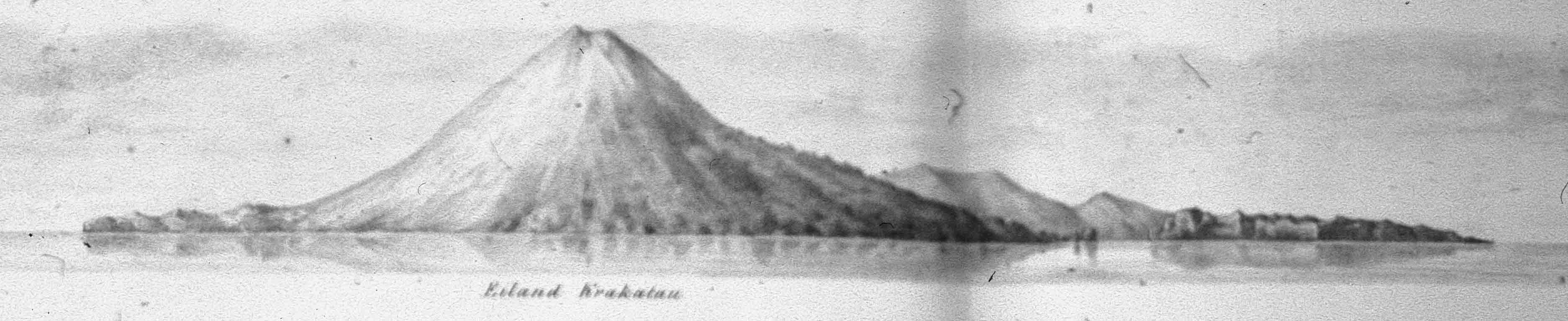
Krakatau before the 1883 eruption. Rakata is in the foreground
Before the eruption, Krakatau was a decent-sized but not particularly tall island. There were several volcanoes on the island. The main peak, Rakata, may have been dormant: the descriptions indicate that the 1883 eruptions were from multiple (simultaneous) vents along the Danan-Perboewatan line. These are the lower cones in the background of this pre-1883 drawing. The main explosion, after four months of activity, may have been at Danan. In the last few weeks before the main event the volcanic activity had been steadily increasing. A few months earlier, a picnic party had come from Jakarta to view the eruption. Two weeks before the final flourish, the main geologist (Verbeek) had refused to go on land in view of the danger.
This eruption sequence seems to have been opposite to that of many other eruptions, which start big and decline over time. Krakatau started with a good-sized bang (VEI-4?), declined, but increased again building up to the cataclysmic event. Why? We may never know. A possibility is that during the four months of eruptions, water had begun to slowly enter the shallow magma chamber, decreasing the melt temperature and increasing the melt fraction. In the end, the main explosion left a hole in the sea floor 250 meters deep and 5 kilometers across, killed every single person on nearby islands and wiped the Sunda Strait coast line clear, not only by tsunamis but also pyroclastic flows. The newly discovered world-wide web of telegraphy lapped it all up.
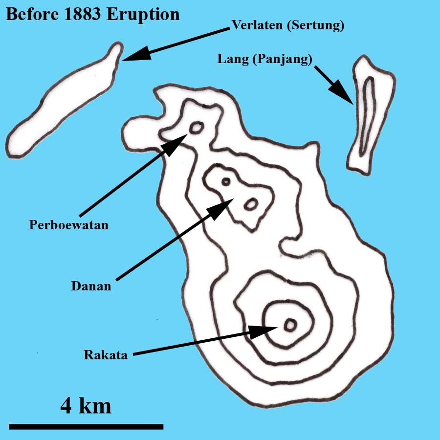
This was certainly not the first time the mountain had exploded: the ring of islands around the explosion dated from one (or more) previous caldera-forming eruptions. But before the rise of the web, the documentation was a bit more sketchy. The stories about a 416 AD eruption come from the Java book of kings:
A thundering sound was heard from the mountain Batuwara which was answered by a similar noise from Kapi, lying westward of the modern Bantam. A great glowing fire, which reached the sky, came out of the last-named mountain; the whole world was greatly shaken and violent thundering, accompanied by heavy rain and storms [‘rain of stones’ in another translation] took place, but not only did not this heavy rain extinguish the eruption of the fire of the mountain Kapi, but augmented the fire; the noise was fearful, at last the mountain Kapi with a tremendous roar burst into pieces and sank into the deepest of the earth. The water of the sea rose and inundated the land, the country to the east of the mountain Batuwara, to the mountain Rajabasa, was inundated by the sea; the inhabitants of the northern part of the Sunda country to the mountain Rajabasa were drowned and swept away with all property. The water subsided but the land on which Kapi stood became sea, and Java and Sumatra were divided into two parts.
This was written up in the 19th century, and is mythology. Three volcanoes are mentioned: Batuwara, Kapi, and Rajabasa. (In another translation, Kapi is a god of fire rather than a mountain: reading it like this makes a bit more sense of the text, but means that the eruption came from Batuwara.) The last volcano is on Sumatra, at the northern end of the Sunda strait and did not erupt. Batuwara is a presumed extinct volcano on Java but it is not clear that this one is actually meant as the story says that the flooding was east of this mountain while the Sunda strait is to its west. Kapi is normally assumed to be Krakatau but the story places it on dry land. The Sunda Strait consists of pull-apart grabens, 20-40 meters deep and has not been dry land in recent times. The story provides many questions! Looking at the detail, it describes a tsunami which impacted the northern and eastern area of the Sunda strait, and is attributed to Kapi falling apart. No evidence for a major eruption around this time has been found. However, it is not described as a major event: it seems to have been observed (by surviving reporters!) from nearby (volcanic eruptions can’t be heard from tens of kilometers away because of the way sound waves bend: people who saw St Helens erupt comment on the total silence). This was not a caldera-forming eruption. The island ring must therefore have formed much longer ago.
Part of the story makes sense after the 2018 event. It describes a moderate eruption from a volcano (which could have been Krakatau but this link is not stated), which slid into the sea and caused a devastating tsunami. A flank collapse, larger than the recent one, could fit the descriptions. We can take from this that tsunamis from collapse event are a recurrent, and reported, hazard in the Sunda Strait.
(It has been proposed that this eruption took place in 535 AD. This was based on indications for a major eruption somewhere in the world around this time, but there is no evidence (at all) which ties this to Krakatau.)

Why is Krakatau here? The whole region is highly volcanic and almost every feature of significance here or on adjacent Java and Sumatra is volcanic. It is near the eastern edge of the old (Asian) continental crust, lying on top of old subducting ocean crust. Rotation of Sumatra has opened up the Sunda Strait. Krakatau lies near the northern tip of one of the basins, the Krakatau graben. Krakatau’s main magma chambers are at depths from 3 to 7 and 23 to 28 kilometers (the moho) and are located at boundaries in the crust. The Krakatau complex produces basaltic, andesic and dacite lavas. It is an interesting and perhaps understudied region.

(Dahren et al 2011)
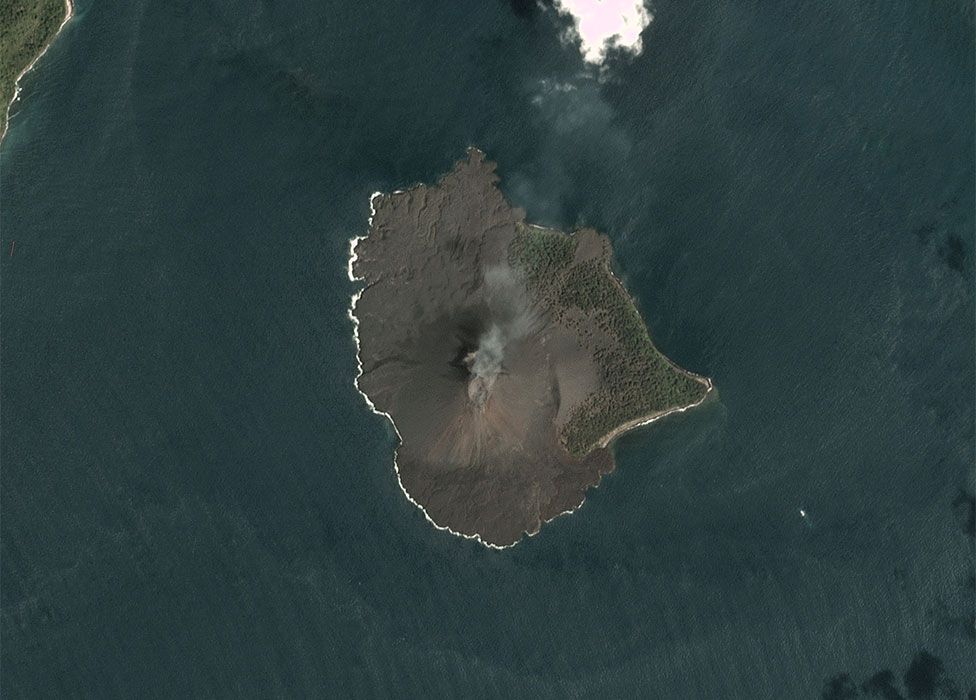
Anak Krakatau
The child of Krakatau was not its first born. The first island showed up in 1927, approximately where Dana had existed before 1883. Presumably it had taken some time before the new cone had build up but this is not recorded. The first island did not last long. In mid-1929 the eruption resumed, and two further islands came and went, until in late 1929 the final island raised its head and managed to grow faster than the sea could take it down. It was probably standing on the shoulders of its demised siblings.
It is interesting that the new cone formed here, on the old line of vents. Such a large event should have destroyed the conduit. After a major eruption, a replacement volcano tends to grow along the perimeter of the caldera, away from the caldera centre. Krakatau is made of tough stuff. (However, the funny part is that the 1883 caldera appears to be to the side of Anak Krakatau. It is not clear why the 1883 caldera would be away from the line of vents. Perhaps Anak Krakatau has already filled in a bit of the caldera.)
Frequent eruptions caused fast growth, by as much 10 centimeters per week. (As an aside, this is about the rate needed to get from 250 meter depth to the surface between 1883 and 1927, but this is speculative.) By 2000, the new cone had reached 300 meters. The height prior to the 2018 collapse appears to have been a bit over 400 meters, after a growth spurt in the preceding decade. However it was still very far from rebuilding the old island. The lava flow rates are not excessive: the island has grown by about 0.002 km3 per year. Presumably only a small fraction of the new magma is making it to the surface. Assuming a fraction of 10%, the magma supply rate is 0.02 km3 per year, and it will take 500 years to recover from the 1883 explosion. That still seems fast, and it is likely that the current rate is above the long-term average, perhaps because of some decompression melt. The lavas are currently basaltic andesite, and probably have had this composition since the birth of Anak Krakatau.
Half of Rataka had survived the 1883 explosion but no life had survived here. Much of the flora and fauna may have died already during the four-month precursor phase. The return of an ecology to Rataka is a case study of how an island can come back to life. Ferns started growing from 1886, gras from 1897, trees shortly after and a forest reformed at the lower slopes after 1920. Nowadays it is dense rain forest. Anak Krakatau did not do nearly as well because of the frequent eruptions. The eastern side became forested, but in recent decades the lava flows had steadily reduced this oasis. Nothing appears to have survived the 2018 events: the current images show devastation.
The 2018 collapse
The collapse event has been well published on our new and improved world wide web. The first sign of trouble was the tsunami which came on Saturday evening, 22nd of December. There was no warning: no earthquake (although there was a minor earthquake in the Sunda Strait earlier that day), and no significant larger eruption (although there was on-going activity with lava entering the ocean). The event was not witnessed.
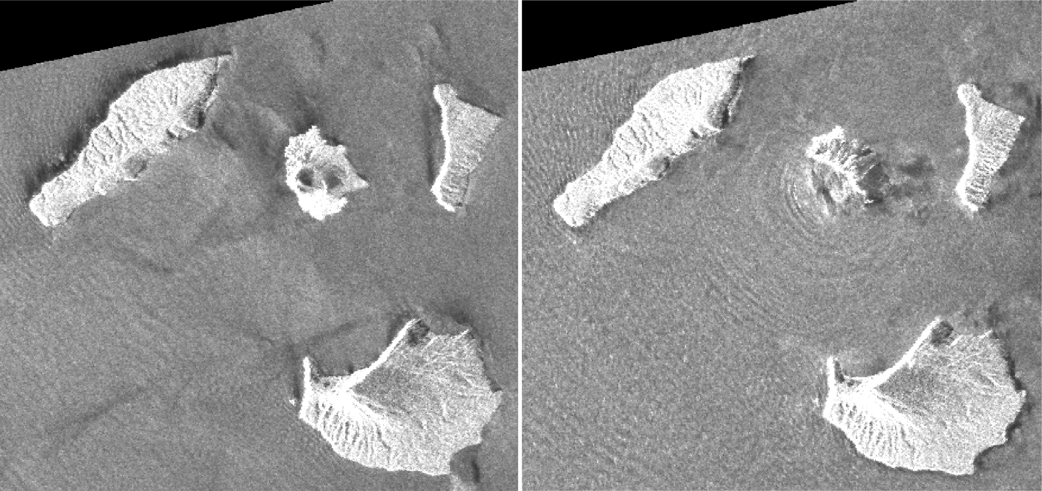
A combination of synthetic aperture radar images taken by JAXA’s ALOS-2 satellite and analyzed by Geospatial Information Authority of Japan, before and after the Dec. 22, 2018, eruption. The images were taken on Aug. 20, 2018, left, and on Dec. 24, 2018, right, respectively.
It took some days for the truth to come out. The thick clouds had to disperse first. Radar images (above) showed the first evidence of a major collapse towards the west. Subsequent optical images showed that, if anything, these first indicators had understated the case. The cone was fully gone. The west side of the island was smaller than it used to be, and the east side had acquired a new cover (obliterating the trees, therefore many meters thick) and extended the coast outward. In effect, the whole island had slightly moved east. For your enjoyment, here are the main images.


Planet Earth, 30 Dec 2018

Planet Earth, 2 January 2019
(A slider comparison can be found on the excellent BBC coverage, https://www.bbc.co.uk/news/science-environment-46743362)
In terms of volume, 160 million m3 has gone, of an original 200 million m3. It is a major set-back in the Krakatau recovery.
It is interesting that the radar images differ from the later optical images. The reason is not clear to me. The collapse may not have been a single event, or the dust was so thick on the west side that radar interferometry did not work well, or (my guess) the radar view was taken from low in the northeast and the southern and western parts were hidden behind the remaining peak from the satellite. The final images show that a bay has formed, open to the west, where the cone existed before. This cannot have just come from the collapse as the material evacuated from the bottom of the bay would have nowhere to go. The central hole may have formed in a subsequent explosive event.
Volcanic tsunamis
It is interesting that the collapse and tsunami had been predicted in a paper from 2011, including the direction of collapse, the approximate volume, and the height of the tsunami. This new mountain was known to be unstable.
How do volcanoes cause tsunamis? There are three main mechanisms. The most obvious is that of an underwater explosion. In fact the explosion itself is likely to be only a part of the story, and the subsequent collapse of the caldera is the main cause. Water falls into the excavated hole, the sea surface drops, and a wave equal in volume to the new caldera begins to move out. The tsunami that follows will begin with a withdrawal of the water, before the main wave comes in. The best example of such an event (probably) is that of the explosion and collapse of Krakatau in 1883.
The second mechanism is that of a flank collapse, where the landslide pushes the water out of the way, and the wave begins to travel. Here, the tsunami will normally begin with the water rising up. As the flank collapse is on one side of the volcano, the tsunami will mostly travel in that direction. The most dramatic example is that of the collapse of Unzen in Japan in 1792.
The third mechanism is very different: it is the fall-back of ejecta from a nearby volcano, especially as pyroclastic flows. These can cause tsunamis even where the volcano is not directly on the coast. The familiar example is the tsunami that followed the (in-land) Tambora eruption.
These events have one thing in common: casualties. Tsunamis are the dominant source of fatalities caused by volcanic eruptions. Ignore the risk at your peril. In the NDVP list, the top two are both tsunami risks.
Flank collapses
What causes a flank collapse? Ultimately, gravity is to blame. Without gravity, nothing would happen. But obviously there is more to it. A flank becomes unstable if it becomes too steep. The easiest way to see is by building a sand castle. Loose sand can only support shallow slopes: the sand grains start to tumble down, until they make a slope of a certain angle. For the same type of sand, that angle is always the same. Add more sand, and the castle gets bigger, but the slope does not change.
What follows is a battle between gravity, friction, and cohesion. The force of friction keeps the sand grain in place. As the angle steepens, friction grows less: it is equal to the weight pressing on the surface times the friction coefficient, and as the angle steepens, less weight is pressing on the surface. (Try this by weighing some object on your kitchen scale while holding the scale at an angle.) At the same time, the force which tries to pull the grains down the slope increases as the angle steepens and gravity more and more pulls it along the surface rather than into it. Try walking on an inclined icy surface and you will see this in action (I remember driving behind a truck trying to get up an icy incline: evasive action was needed. I made it – the truck didn’t.)
But use sand with rougher grains and the angle can become steeper before the cascade starts. Make it wet, and for the right kind of sand (i.e. rock) the slope can become near vertical. The cohesion of the material is thus very important.
The angle you end up with is called the angle of repose, and for many materials it is around 30-40 degrees.
How is this for volcanoes? It strongly depends on how the volcano was made. The sand castle above is most like a scoria cone: material thrown out by the volcano, solidifying in the air and coming down as fragments of varying size. Such a cone may become fairly steep, but it will always be at the angle of repose. Loose tephra may do the same thing. Lava, on the other hand, is a liquid and it laughs at friction. It flows easily, and therefore build shallower slopes, of perhaps 15-20 degrees. Basaltic volcanoes have lava with low viscosity, and this builds even shallower slopes of perhaps 10 degrees. When the lava solidifies, it freezes in position. This mountain is now quite stable, with an angle well below the critical angle.
This makes it sound as if only scoria cones could collapse. In fact, it is the opposite. Scoria cones (and similar) form at the critical angle and can (badly) cascade but rarely fully collapse. The risk comes from volcanoes that grow at too steep an angle. How can that be?
In the case of basaltic volcanoes, the instability happens some distance along the slope. Lava is fine as long it can flow, but after some time it cools and becomes solid – and stops flowing. At this point, the slope will become much steeper. Hawai’i is a point in case. Look at the profiles: you will see that they steepen a lot under water. Once lava reaches the sea, it cools almost instantly and stops flowing (or flowing far), so here is where Hawaiian volcanoes become really steep. The flow rate also plays a role, as that determines how far lava can get before cooling (higher flow rates give thicker layers which cool slower and can therefore reach further). The Holuhraun flows reached a certain distance – and no further. As the eruption waned, the flows no longer reached the edge of the flow field. Look at Olympus Mons: it is surrounded by a steep cliff: this shows how far the summit lava could reach.
Another way of steepening the slope is by having a magma intrusion, especially if this is along the flank. This is what killed St Helens. It is a slow hazard in inflating, pre-erupting volcanoes.
So now we have a steep slope near the bottom of the volcano. How does a collapse happen? Say the whole thing just about hangs together. Near the bottom, a small collapse occurs. This makes the slope just uphill slight steeper. It also begins to collapse, and so a small collapse travels uphill. But now a new law of physics kicks in: the coefficient of friction is smaller for moving objects than it is for stationary ones. As soon as the slide begins, friction reduces and the critical angle becomes shallower. And suddenly the whole mountain is over-steep and unstable. The collapse has begun.
Another way for reducing friction (best avoided) is by adding water. We all know how dangerous aquaplaning is. Fracking can cause earthquakes by injecting water into faults and so reducing the friction that keeps the fault locked. Steep slopes can suffer the same problem when they become water-logged. Typhoons cause landslides just from their rain, leaving slopes too steep to support themselves. Physics can be an unforgiving bastard.
Shaking can also reduce friction, The Hokkaido earthquake did this most effectively. The top layer of the soil was ejecta from an ancient eruption, a thick layer of eroded tephra. The earthquake caused it to slide at every steep surface.
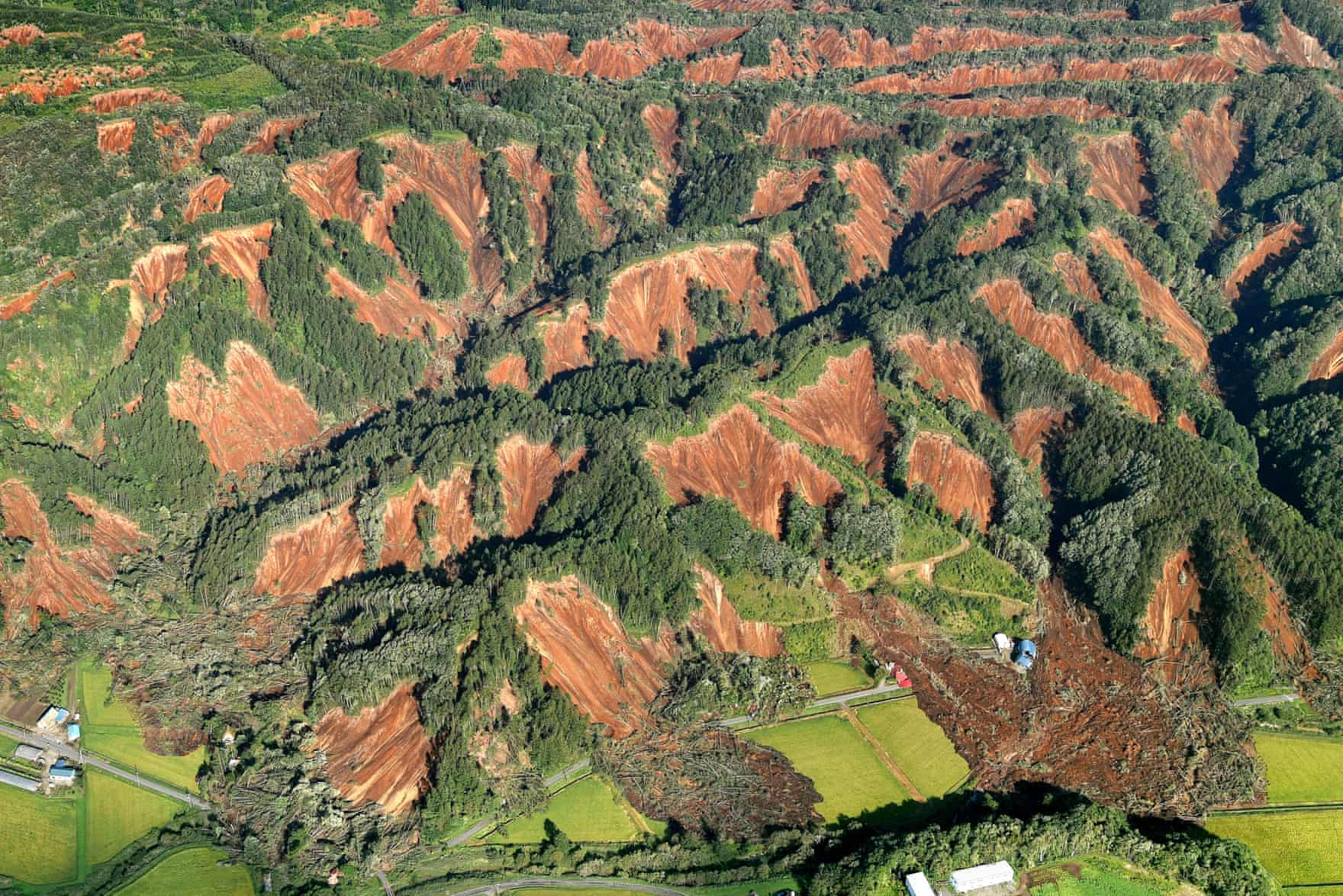
Landslides after the Hokkaido earthquake
The collapse of Anak Krakatau
So what happened? A hint comes from the location of the new island. The map below, from Deplus et al. 1995, shows the 1883 caldera, viewed from the west. Anak Krakatau grew up on its edge. (This is a bit funny (this feeling inside) as it puts the 1883 explosion (implosion?) well away from the erupting vents.) But in consequence the slope was far steeper to the west, into the caldera, then in the other directions.

The 1883 caldera, viewed from the west
Look again at the satellite images before the collapse. There is a small bay visible on the west. This was already present before. Comparing the 2014 and 2018 images, the island had expand to the south, making this small bay more prominent. The volcanic cone reaches the bay, as shown by radar image above.

2014 Landsat image (viewed through google earth). Click for full resolution
2018 satellite image. Click on the image for full resolution
Sometime (probably 2010/2011), a lava flow reached the ocean a bit north of the bay. On the image slider one can see that the area that collapsed extended from the bay to just north of this lava flow. Perhaps the lava entering the ocean prior to the collapse pushed the slope beyond the limits. A section of coast gave way, possibly at this bay where the steepest slope occured, and the collapse progressed towards the adjacent caldera. This steepened the slope, and more began to slide in. A runaway process followed, with the collapse engulfing the cone itself. The massive slide caused the tsunami.

The collapse exposed hot material to the elements and sea water. This was the cause of the clouds, and the clouds carried ash up with it. It reached to high up in the troposphere. But little new ash was generated: what came was from a limited amount of magma entering the water, causing a phreatomagmatic explosion. The clouds, in contrast, came purely from the exposed heat.
But it is hard to stop magma. The conduit was close to water level, but worse, was sideways exposed. The main explosion now took place here, caused by water coming into contact with the conduit. It was this event which caused the semicircular bay to form, excavating the cone now to below sea level.
This scheme is speculative: we have no evidence other than the images, and it is also possible that the collapse began with a volcanic explosion at the summit. But I consider the speculation here as more likely.
The future
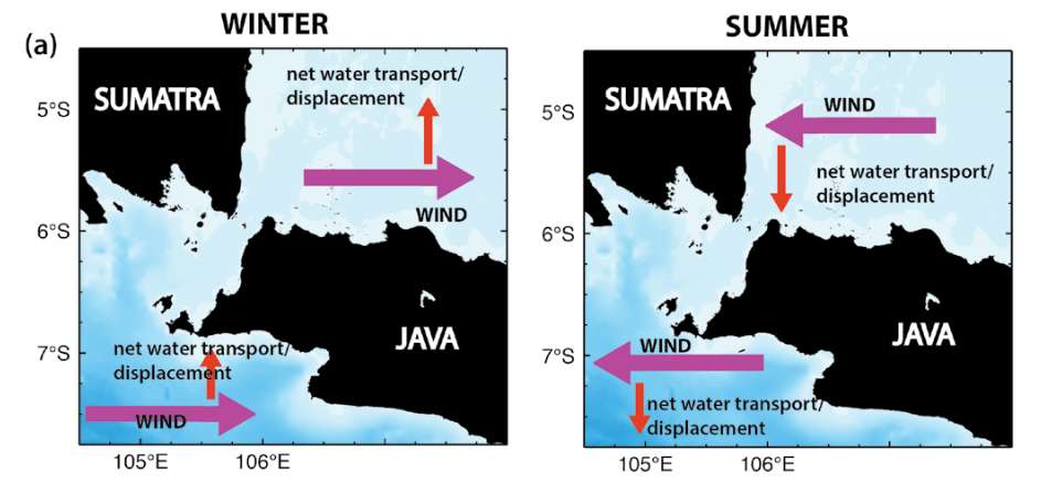
Wind and current around the Sunda Strait
Note the curve enveloping part of the new bay? It is not clear what caused this, but a plausible suggestion is that is material collapsed to the south, and transported by wind and water to here. The map above shows the dominant wind and current direction this time of the year (left). The water was always shallow to the south, outside the 1883 caldera, and much of the material will be close to the surface. I expect that this transport will begin to fill in the new bay – whether it can close it off depends on how deep the new channel is. Further collapses along the edge of the new cone are likely to also fill in the bay, perhaps quite quickly.
Eruptions will also continue and may even intensify. A new cone is likely to form very rapidly, as the magma chambers have been left untouched and the confining weight reduced. How quickly it reaches the surface depends on the depth of water. That is not known. The width of the waves inside the bay is similar to that outside. That makes the water much deeper than the wave height. I would guess it is at least 10 meters but may be much more. But at this depth, the cone could break the surface within a few years – and earlier if infilling from elsewhere continues.
Full recovery will take longer. It may take 50 years before Anak Krakatau reaches its pre-collapse height.
And will it collapse again? Assuming that 100 million m3 was deposited in the old caldera, that is still less than 10% of the volume of the subsea caldera. The hole next to the child is still there, waiting for a wrong movement. But it won’t be as deep close to the island, and therefore the new cone will not be as unstable. That means it may grow larger before history repeats itself. This will not have been the last tsunami to hit Anjer. The world wide web of those days will be ready.
Albert, January 2019


Uhmmm
“The name of the volcano changed from ‘Krakatoa’ (the Portuguese spelling) to the one used in English even today, ‘Krakatoa’.”
Fixed. That was quick – I had only just published it.
More typos are not unlikely..
There is no k in the Portuguese alphabet.
That is interesting. Perhaps a knowledgeable reader can comment on this: I read that ‘k’ is allowed in imported words.
Pretty sure the dropping of the K and Y from Portuguese was a 20th century thing, when they tried simplifying things by decree. At the same time PH was substituted for F. Of course languages don´t change by laws, but by natural evolution so this hasn´t worked out.
Could be worse…
“The Indiana Pi Bill is the popular name for bill #246 of the 1897 sitting of the Indiana General Assembly, one of the most notorious attempts to establish mathematical truth by legislative fiat.”
https://en.wikipedia.org/wiki/Indiana_Pi_Bill
“Upon its introduction in the Indiana House of Representatives, the bill’s language and topic occasioned confusion among the membership; a member from Bloomington proposed that it be referred to the Finance Committee, but the Speaker accepted another member’s recommendation to refer the bill to the Committee on Swamplands, where the bill could “find a deserved grave”. It was transferred to the Committee on Education, which reported favorably”
“Professor C. A. Waldo of Purdue University, who happened to be present in the legislature on the day it went up for a vote.” and convinced the legislative body of the stupidity they were embarked on.
Time lapse from yesterday. This went on a good six hours. Finally they have a camera on it.
Thanks for the article Albert!
I recognize the flank collapse of a gravel pile whilst looking for agate and jaspers very well!
😮😅
Have mentioned it before, I think in my first post when I signed up here. I have a signed copy of _The twenty one Balloons._ It always amuses me that they had a secret utopian society, not far from some of the most populous places on the planet.
Following on from the eruption size discussion on the last article, I also now have my doubts this eruption was at VEI 4.
Earlier on I worked out that if kilauea 1959 was tephra it would have been a solid VEI 4 and actually pretty big as 0.25 km3, and most of that was in the first week of the eruption filling the crater. I chose this eruption as comparison because it is one I know a lot about and also because it is maybe the best example of what a VEI 4 would look like without tephra obscuring the lava fountain/jet.
This is anak krakatoa next to kilauea iki when the highest fountain was active (actually over 2 weeks after the main episode but still).
Anak looks impressive because it is in the ocean and rises out of nothing, but in actual size it is not that big, only about 3 km2 area, the entire island could fit entirely within kilaueas 2018 caldera at least twice and its summit wouldn’t reach the top.
The 2018-19 eruption is maybe about half way to being a VEI 4, it lasted 5 days at much less than the eruption rate of kilauea iki, and all of its volume was in actual tephra to begin with while the already larger volume of kilauea iki was solid lava that I equated to tephra volume. Anak 2018-19 is at best about 0.05 km3, a VEI 3, though one with rather larger consequences than the average VEI 3 so it could still be apt to call it a ‘major’ eruption on account of that.
In terms of danger though, it is already more lethal than Kilauea. Hard to compare effusive and explosive volcanoes. That seems to be the problem being debated on this blog.
Effusive eruptions (unless they are flood basalts) can erupt a large volume of material but with less lethal force than a smaller volume of material from an explosive volcano.
The comparison wasn’t about lethality of the two volcanoes, if it was I would bring up 1790, or the near-identical risk presented right now). The comparison was really more about how big anak actually is, with the answer being not very, in fact kilaueas caldera is actually not much smaller than the 1883 krakatoa caldera, just as a point to mention on size.
The aim of that comparison was actually to compare to an eruption that was comparable (not the best but most visible) to the recent eruptions from anak, but which was not covered by tephra. And also to show that anak krakatoa would literally fit inside kilaueas caldera with much room to spare. It also gives me another way to display how big effusive eruptions actually are, as kilauea iki is listed as VEI barely-2 when it had both the volume and speed needed to qualify for a solid VEI 4 if it was all tephra. It also shows eruptions of that size can happen from normally effusive volcanoes without altering their pre-eruptive behavior, important now considering 1959 was the first eruption after an eruption in 1955, which was also in the same place as last year, with a several year dormancy preceding it, the similarities are more than coincidental…
Yup Anak Krakatau is tiny compared to Kilauea
But all other volcanoes are very small compared to the hawaiian giant
Here is a rough outline of anak before dec 22 over kilaueas caldera, it is quite small when put in context. It has taken 90 years for anak to grow to the size it is now, but if a phase of intense summit filling begins in kilaueas new caldera it could easily erupt the same volume as anak contains entirely within a year.
Another way to put it, at its largest, only a week before it disappeared, kilaueas lava lake was 250 meters wide and based on how far it sunk before anything started happening, it was at least 400 meters deep, 20 million m3 of lava just sitting there 300 meters above an already open vent for 10 years (really this shows something was bound to happen eventually), this is the same amount of lava as would be needed to construct a tephra cone with a volume of 60 million m3, which assuming a cone shape would be 800 meters wide and 400 meters high, almost as big as the one anak had made before dec 22, and this was just lava that was entirely molten just sitting in a crater continuously for a decade.
It is a bit of a stretch to compare an effusive volcano that has been active for 300-600 k years with a very explosive one that regularly completely destroys its own edifice. That the caldera is bigger for an effusive volcano is quite logic too since here complete chambers drain out regularly , whereas for explosive volcanos the caldera relates to very big explosions but not necessarily completely empty chambers.
Same with comparing the energy equivalent of effusive eruptions with explosive ones. The energy involved may be high, but that is just a characteristic of effusive volcanos. The energy involved often is high, but explosive eruptions are for sure less predictable and more dangerous than effusive ones. Comparing the death tolls clearly shows that. The current VEI system has its flaws obviously, but at least it gives some idea of the danger involved. Since the whole setting of the volcanos is completely different (hotspot, effusive, age, water-interaction, etc.) it is comparing apples with pears.
That pic was to show a birdseye of the sideways model I made before, though I realise it is the wrong direction now. I’m not saying kilauea is the best comparison for krakatoa because it isn’t, but more showing how big anak actually is in reference to another volcano we have all become very familiar with this past year. It was also in part to show that this recent event from anak, while certainly its biggest eruption since 1883, is not very big still, and is very unlikely to be a VEI 4 even if the scale of eruption could have been.
Kilauea iki 1959 is also a good model of a ‘red’ VEI 4, meaning it didn’t erupt much in the way of tephra but if it did it would have been VEI 4. Actual VEI 4s are ashy, and estimating their true volume is hard because ash goes everywhere and a large portion of the ash is dispersed so far it can’t be mapped. Looking at the night time of calbucos 2015 eruption though, you can see that within the ash column is a lava fountain, and a gigantic one at that at over 1 km tall in that example. This is why at one point I proposed (and still propose) to have a new branch of the eruption style line which goes direct from hawaiian to plinian and is specific to high volumes of fluid magma that is erupted at very high rates, the other styles require evolved magma at low rate, and strombolian is just low rate eruption in general, but a very intense basaltic eruption can transition from plinian to fast hawaiian rapidly in a single eruption, eg skaftar fires. It has been noted that the kilauea iki fountain had many attributes of a plinian eruption, like deep degassing over 1 km deep and a ‘gunbarrel’ vent, something not observed to the same extent on high fountaining vents on the ERZ later in the century, and the composition of the lava became very basic at the time of the high fountains, almost ultramafic and probably some of the hottest lava erupted in recorded history (1300 C). This can be seen with how little time it took to erode the fissure to a wide open vent, and that the lava falling around the fountain flowed off instead of building a large cone.
Again, I was not comparing death toles, but the ~1790 footprints ash eruption most likely had a higher body count than what anak did recently, the number is usually quoted as 250, but ranges between 80 and 5000, and using median numbers a toll of at least 1000 is not unlikely, the people who made the footprints were also not in the firing line, Keoua and his army were on the caldera rim when it happened, and while no-one knows for sure I can’t imagine him trying to challenge Kamehameha with less than 1000 of his best. That eruption could have changed world history but I won’t go into that here, save that for another time.
Objectively, standing on kilaueas caldera rim is way safer than doing the same on anak right now, but nowhere in the original post was I talking about that, only the relative scale. Anak is just the polygenetic version of something like paricutin, a generic pyroclastic cone, it just happened to grow in a notorious place and do the wet sandcastle thing.
I think the point regarding the size of Anak Krakatau in comparison to Kilauea was well made. And I agree with your assessment that AK was at most a VEI3. Assigning explosivity numbers is always tricky and I think the only reason why the volume has become the main criterium for VEI class is that is easily measured. It is in ash/tephra though, not DRE. But is this the best measure for explosivity, i.e. sudden release of energy driven by gas volume)? This argument has been going on for sone time, also on this site. The second argument is height of the eruption column and this is probably better, but we found out with A. Krakatau that it can measure heat-driven cloud formation – and that was not the idea.
Explosive eruption may have very little lava. The tephra comes from disintegrated rock – and this is a measure of explosive energy.
What we need is separate measures for ejected rock volume and lava volume.
Still waiting for replies from the emails I sent to a few volcanologists about this, but having seen this:
I think I might (just slightly) have jumped the gun when declaring VEI-4(!). I think Turtle is probably right- mid VEI-3 (~0.05km3) or maybe slightly higher- there have been powerful discrete explosions in the last few days and if you count the earlier activity last year. Maybe if the rest of the island does collapse it could then make it to the 4 boundary- and maybe applying the + sign for high end VEI-3 eruptions instead of just for 4-7 might not be a bad idea.
Perhaps the fact the Darwin VAAC described it as a 55,000ft *ash* plume wasn’t the best thing to do. The actual ash was maybe around 35-40,000ft.
Something similar might apply to the 2014 Kelud eruption- most of the ash was “only” around 65,000ft, but with a very tall umbrella overshoot to almost 90,000ft. It would also be useful if we had some idea of the typical ash content percentage in a Surtseyan plume.
Last thought- it is a good job it didn’t end up St. Helens-esque and that it happened at night. Otherwise we could have ended up beating the 2004 tsunami as the worst disaster in recent history….
Just to catch a bit on what you said on Calbuco…
By the looks of it, the eruption came in 2 phases, one happening in the afternoon and being very ashy, and the other, far stronger, happening at night and being extremely scoria rich.
Even if Calbuco is an andesitic volcano, I believe the magma was actually quite fluid, there was mention of some lava flows happening during the pause between the 2 phases.
My humble guess is that the first phase was actually phreatomagmatic, with rising magma contacting the hydrothermal system (it rains heavily in this part of the world, and Calbuco is known for being covered in snow most of the year).
Once the water was exhausted, there was nothing to fragment the magma, so some lava flows seeped at the end of the phase.
Then a new pulse of this time very fresh, gas-rich andesite rose up, and a paroxysmal lava fountaining episode with heavy scoria emission and not so much ash. The heat generated caused the volcanic plume to reach 15+ km high, and fast accumulating scoria on the slope came loose and caused avalanche pyroclastic flows.
Just my off-topic 2 cents…
Makes sense, after kilauea last year there is now reason to think that other magmas can be fluid. I think the general reason rhyolite is viscous is because it is cold, most rhyolite is erupted almost solid at 650 C. Rhyolite that is 1200 C probably wouldnt be much different than basalt, maybe not quite as fluid but definitely not to the point it would be immobile. In fact, glass is technically a sort of very alkaline lava with even higher silica than rhyolite, but it flows very easily and is probably more fluid even than basalt when freshly poured at somewhere around 1500 C (that temperature is to melt the sand, it doesnt melt that high afterwards). Obsidian flows are probably hot rhyolite, maybe 900-1000 C, domes and explosive deposits are probably colder stuff.
Hekla and fissure 17 erupt andesite with nearly 60% SiO2 which is true andesite and not even close to the <50% SiO2 of most other lavas in those areas, yet both volcanoes are effusive (well mostly) and their lava flows easily and looks like basalt when molten. I think the more intense phase of fissure 17 was probably more basaltic as the dike surfaced though, when the fountain went from 20 up to 150 meters high for a few hours. It will be very interesting to see the puna region when google earth updates, with the viscous looking fissure 17 flow next to the pahoehoe of 18-20.
https://youtu.be/wkEVwEwT9GE
The melt fraction is very important. The lower the melt, the more crystals are in the magma/lava and the mushier it becomes. Hence the viscosity. Making it hotter will certainly help. But it is rhyolite because it has cooled: to get fluid rhyolite you need considerable reheating. It happens but is not common.
Doesn’t the bay seen on the dec. 30. Planet Earth picture seem to be quite different from the bay on the jan. 2. picture? Look at the waves. Looks like it almost has inflated or been almost refilled. With mudlike material?
Any thoughts?
It looks like that. The cloud also suggest new hot stuff was in contact with the water. But wait and see: floating flotsam can disappear quickly.
Links:
Volcano Discovery: https://www.volcanodiscovery.com/krakatau/news.html
National Geographic?: http://nationalgeographic.grid.id/read/131351729/ditemukan-retakan-baru-di-krakatau-bmkg-imbau-warga-waspada-tsunami-susulan (Use Google Translate or other translation tool)
Oops. The links are for Espenb’s comment below, discussing the new cracks seen in Anak Krakatau.
New cracks in krakato. Fear of a new landslide. This time anak desintegrad slowly compared to the last big one in the 1880s.
This is from the Indonesian authorities. “long narrow spaces between parts of the volcano were detected through photographs shot from the air at the southward end of the crater”
They estimate the first slide around 99 million m³, the new landslide may amount to as much as 67 million m³, should everything mobilize in one go.
Very good article, thank you for the time involved!
Is there some further research done regarding the age of Krakatoa? And I read somewhere that the theory of magma entering the chamber in 1883 resulting in the loudest sound heard by mankind is disputed. It may have been a rapid intrusion resulting in a magma mix that made the volcano above go nuts. I recall faintly that I read about that somewhere on volcanocafe, has anyone got more infos about it maybe?
Nothing is known! One interesting bit is the evidence for a major tsunami in South China around AD 1076, together with a major tsunami in Australia around the same time. The Sunda Strait is one of the few area able to affect both these regions..but it is hard to see a single volcano do this, and there is no record of an event at this time in Java. A megathrust quake over an extended area (Mariana trench?) may be more likely. Or the dates are a coincidence!
I’ve sort of thought that the four titanic explosions were related in some way to the collapse of the edifice, which is thought to have given way piecemeal rather than as a single block. After all, the eruption had been going full blast by this time for some hours, so pressure wasn’t building up, magma was being released freely.
So how’s about this for wild speculation: at the point of collapse, enormous quantities of sea-water are suddenly placed in intimate contact (oo-er, missus!) with enormous quantities of rapidly de-gassing and fragmenting magma, Conditions, perhaps, for a form of ‘fuel-coolant’ explosion? Which would be a genuine, high-intensity, explosion. Any thoughts, anyone?
Just as an educated guess, in my opinion, the main factor at play here was water, when it boils it expands up to 1600 times in volume.
Just remember there were several km3 worth of 1000°C magma still sitting in the system, and a technically unlimited supply of water. Mix everything up, and you will rattle windows 4000 km away.
Had the volcano been on mainland, we would have had a Pinatubo or Santa-Maria style event. No discrete mega-explosions, but the land would have been smothered in pyroclastic flows.
Another great article, Albert, Thanks. Regarding the fundamental forces you mention effecting the shape and stability of a slope… water not only causes erosion and effects the rate of cooling, the never ending hammering force of waves has got to be considered as one of the major shapers of volcanoes near the sea. For instance, it seems to me the Hilina Fault has a large effect on the events at Kilauea and the fault slips in part due to wave erosion. Maybe the recent increase in the number of hurricanes in Hawaii will have an effect on the stability of that fault system. I wonder about the amount of activity along the Hilina Fault.
By a large effect do you refer to volcanic processes? cause the Hilina faults form a separate system from the ERZ-Koae faults which are the ones that take part in volcanic or intrusive processes. The Hilina Faults are a series of detachment faults close to the shore that form as blocks of the south flank slide down due to the steep slopes just offshore that rapidly drop to a depth of almost 5 km below sea level. Waves do not get enough time to have a significant impact on the volcano, erosion is way too slow and lava flows rapidly form new coast. Even in many of the extinct volcanoes of the chain subsidence outpaces the effects of the waves and won’t allow tall cliffs to form.
The only way something like what you are talking about could happen is if the entire thing slid off, an event that especially after this year has been deemed almost impossible right now. It will happen eventually but kilauea probably has to be at least comparable to mauna loa before that happens, give it 100,000 years or so. The only water interaction is when the caldera is deep enough to form a crater lake, or in the LERZ, as shown by kapoho and puulena crater and early 1960, as well as maybe fissure 22 later stages and some of 1955. Why 1960 didn’t become like kapoho crater is not really known.
Speaking of this, the new caldera is not quite at the point deep enough to make a lake, the water table was measured a few weeks ago and is less than 20 meters below the bottom of the crater but still too deep. A lake is needed to get a big explosion so that is probably not a risk now, though being near an eruption big enough to throw tephra out of the caldera is not a good idea. The groundwater from all the hurricanes last year might change this a bit though as all the rain that fell on mauna loa will take maybe over a year to even out again so it’s all uncertain still.
Found this paper. This is a paper about the geothermal venture and a lot of the science that came up while working on it. I would imagine that the water moves off of Moana Loa a little faster than it percolates thru the ERZ.
” In general, the direction of water flow is from the summit of Moana Loa towards the ocean. Isotope hydrology has shown that water in the ERZ recharges at elevations of 1,300-2,800 feet (396-853m) and discharges south of the ERZ after about 10-20 years, yielding an average flow rate of just over 1 mile (1.6 km) per year.[23] ”
https://openei.org/wiki/Kilauea_East_Rift_Geothermal_Area
Albert, according to your theory the slide happened first and then the eruptions came from water touching the hot vent that was exposed. Was the eastern area of the island covered by the explosions afterwards? Because that is a lot of material that got deposited there! The whole coastal line has changed and the trees are completely covered. The slider comparison on the bbc website indeed is very good and shows that most of the cone is gone, only the flatter parts of the island remain, with big changes on its eastern side.
Almost the entire island was covered in meters of ‘stuff’ apart from the northernmost point. Most (by far) west south and west, as is shown by the extent of the coast and the discolouring of the water. I think it came from the collapse, which threw enough material in the air (landslides are very dusty events.) The phreatomagmatic explosions once the water entered the conduit wold have added but it is hard to see that that could have caused many meters of ash without giving any at nearby islands and coasts.
There would have been another contribution to the post-collapse explosion. The top 400 meters of material above the magma column were abruptly removed, which means about 400 meters of the magma column, from the point where gas had previously been exsolving down, would have degassed. Abruptly. Picture a champagne bottle scaled up until it is 400 meters tall and 80 wide, and then someone pops the cork, and you have an idea of how much of a contribution this would have made. It was likely guaranteed that the collapse would have been followed by an explosion in the vent of at least this magnitude, even before factoring in that part of the magma column became exposed below the waterline in this instance.
Don’t think that the cone collapse was a single event. The first might have been the largest – hence the tsunami, but later land slippage seems to gave occurred from the satellite pictures. Possible that once the cone had started to collapse, the eastern side became unstable so there was landslip towards the east as well.
It looked to me that the first landslide got rid of half the cone, but the subsequent eruptions got rid of all of the cone and left the vent underwater.
I’ve been watching it, for some reason Sunda arc volcanoes I find particularly interesting.
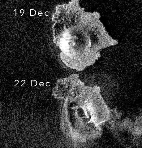
The radar images of 22 and 28 december show differences on the northeast side. That may well be due to a secondary collapse.
I would say the small portion of the cone that didn’t collapse was simply blasted out by the intense explosions.
Love the article. Albert do know where i can find information on Clear lake? The lack of data on it is frustrating since it is a fascinating system and is experiencing elevated activity.
I’m fairly limited by the data acquisition features of their site, but using their plotting function I show this.
Clear Lake is taken to be on top of a large crust block that is subsiding to the North. It makes sense that as pressure from the regional plate motion would impart a push on one side of that block. This is similar to how the transverse ranges form near LA.
Plot derived from this site: https://volcanoes.usgs.gov/volcanoes/clear_lake/clear_lake_monitoring_14.html
Yes, I noticed a slow shallowing trend in the quakes. Since the area is in the Clear Lake Volcanic Field, you can’t rule out that something is afoot, but this does not prove it. (Since I can’t easily pull this quake set I can’t do anything more with determining a trend)
A check of the seismic data maps shows no earthquakes in the volcanic system, there is a geothermal plant where the current quakes are- it always has high seismicity and this is completely normal. Besides, if something was happening there, CalVO would’ve raised the alert level- which they haven’t.
Fully agree.
Note: I have no idea from where the linked web app pulls their quake set. But USGS doesn’t show anything remarkable in it’s current listings for the region.
I don’t really think that it is going to erupt or anything like that but there is no instrumental data to analyze or any in-depth studies to judge anything. The volcano is an odd one so we don’t really know what the seismic activity means but something rubs me the wrong way with the nonchalant reaction from the USGS.
They can’t be “nonchalant” when nothing unusual is happening.
The spam monster ate my comment.
It did. It is a great privilege: it likes you.
My comments aren’t going through.
I think the problems you had at registration has tripped some sort of hyper bot to flag all your comments into the pending queue, we are aware of this issue and are actively trying to sort it for you.
Krakatau live feed here
https://www.youtube.com/watch?v=FfEqIalHAro
it is quiet right now but has been doing explosions (largish) mainly at high tide. Yesterday it was very busy and ditto the day before.
It has quietened almost completely today- for now anyway!
Something I have noticed on the video taken from the boat, the eruption they observe doesn’t happen inside the bay, it looks like there are now more vents, maybe a short fissure. Some blocks also glow enough to be incandescent in the webcam. Maybe when the vent becomes subaerial again there could be more than one active vent, forming several cones or one longer one, either way it probably won’t look like it did before.
I think it looks like it is inside the bay. At least it looks like the southwest peninsula is between the camera and the explosion, which puts the explosion inside the bay.
Fantastic article – thank you very much for your hard work!
Note of interest: Stromboli activity is unusually high. It may be verging on an overflow. Great photo-op if lava starts flowing to the sea. Also a very bad day to visit the summit. (If they allow people to do that anymore)
People are still normally allowed up but they temporarily closed access a few days ago.
Very wise from the looks of it. The summit seems to be a tad unsafe right now.
It would be nice if they fixed their summit live streaming webcam!
Just a point of interest, it has been 4 months since kilaueas eruption ended, the longest time there has not been an eruption in Hawaii for 33 years. At the current supply it will have recovered close to 0.1 km3 of magma, my prediction I made in November was that kilauea would erupt anywhere between February 26 and April 20, by April 20 the added supply will have reached almost 0.2 km3, this is important because that is the number I think needs to be reached before another eruption can occur. The summit collapse was 1 km3, and the eruption was 1.2 km3, the difference is taken up by land that subsided but didn’t collapse. The caldera is permanent, so only the 0.2 extra is actually going to allow for inflation and when that is filled the pressure will probably cause an eruption. I disagree with HVO, I think the summit is the most likely spot for an eruption especially with how fractured the rock is. Other LERZ eruptions are usually followed by summit eruptions too, so this is most likely. Probably once halemaumau has filled up a bit is when the rift will erupt again.
I think that some point this year an eruption on mauna loa is going to happen pretty spontaneously too, it won’t go unnoticed and will be seismic, but not preceded by much deformation or warning more than a week in advance. Even if mauna loa has only 5% of the hotspot that is 0.4 km3 of magma that has accumulated, so it’s not like it actually needs a big push, and this could only be because kilauea recently deflated and allowed some space for the pressure to lower in its neighbor too. 0.4 km3 is also more magma than was involved in 1950, and eruptions there alternate in such a way that the next flank eruption will probably be on the southwest rift, which is pretty much the worst case scenario. Hawaii made a big impact last year but I don’t think it is done yet, quite a horror story it would be for last years events to repeat in ocean view estates…
You talk about 0.2 km³ that should be filled by April but the problem is that the summit has still not started to inflate, the vertical component in all summit GPS but UWEV show continuing deflation. This deflation adds to that of the eruption making the recovery of the summit longer. I also initially (when the eruption ended) thought the summit was the most likely location for the next activity to take place, based on past historic events, but now with the summit deflating and the MERZ inflating it starts to seem more likely to me that next eruption will be downrift of Pu’u’o’o. It is usually assumed that the head of the system needs to be pressurized for flank intrusions to occur but somehow the summit has been able to keep sending magma into the rift without recovering from the eruption.
The SWRZ of Mauna Loa is a long one and Ocean View is far downrift. Eruptions are more likely to occur in the upper half, it would be very bad luck for it to be destroyed by an eruption so short after what happened in Leilani. I know it will eventually happen but it will probably not be in the next eruption.
None of the GPS are deflating, only the tilt is showing a slight deflation and that is on the scale of half a millimeter a day, even the day night signal is bigger. CRIM is moving down but with that also being the closest one to the caldera I would take it with a grain of salt, UWEV is on a much more stable block of land outside the collapse, and it is showing inflation signals…
I also think the middle rift is a future active area as I have said before, but with the summit being so deep and fractured I doubt it really has any resistance to magma moving through it, so once there is enough pressure I think the summit will erupt first followed by resumption of rift dominated eruptions once halemaumau has filled somewhat again. After all the other large LERZ eruptions the first activity has been at the summit too, so this would make sense. 1961 also happened primarily between where pu’u o’o is now and heiheiahulu, so maybe the pattern seen now is not unusual after eruptions in the LERZ, heiheiahulu shows that stable conduits can exist that far down the rift but this years eruption as well as 1960 shows that stable conduits cant exist down to leilani estates and seem to stop at about where heiheiahulu is, probably between mauna ulu and heiheiahulu there is a continuous magma body, and this is connected to the summit by complicated means and likely also connected directly with the deep supply, and maybe also the SWRZ through the koae faults. At the moment though only the lowest end is likely to erupt, but if that doesnt happen then eruptions in the higher areas could occur, I would like to see a large intrusion to the koae faults which results in a sizable eruption, not a tiny spattering crack that took 50 years to find like in 1965. That probably almost happened during mauna ulu, and the 1974 eruption was partly in the koae fault triangle, but then the 1975 quake drained everything down further so eruption resumed about 7 years later beyond napau and formed pu’u o’o. Now that has happened again even further down, so maybe in 1-10 years pu’u o’os successor will join the scene.
I was not predicting mauna loas next eruption to be that far down the rift, likely it will be a small summit eruption like 1975 or maybe even several, but eventually a flank eruption will happen to release the pressure. It might not be that far down, but if it happened there it would be a disaster, and probably the first eruption from an effusive volcano since 1977 to have a death count exceeding 1…
Should we also have to consider that this combined system has had a place to vent gas/pressure for a long while. This is now gone and “I think” this may reduce the amount of time till we see some action.
CRIM, OUTL, AHUP, PUHI and DEVL are all showing deflation. CRIM might be slumping into the newly formed caldera but the others should be in stable ground. The deflation seems to affect the southern caldera and the UERZ, or basically the area that would concentrate most of the magma storage of the system, at least the eruptable magma.
I just came up with an idea about Koae. I have read that the reason why eruptions do not occur in the fault area is because confining pressure is too low and can’t push magma to the surface, that made sense at its time, but now I don’t really see why the confining pressure should be lower there than in the ERZ. The rates of extension in Koae are either similar or lower than that of the rift zone and if there was such difference the ERZ would probably just intrude more often until reverting the low stress. I have an alternate theory, I think Koae is just way too high, remember my attempt to estimate Haleakala’s past height?, well I don’t know if it went very well but it can probably be better applied here. The rift zone slope I obtained for the ERZ of Kilauea is of 0.02, the rift maintains a certain equilibrium so that if a tall shield forms in the rift then it is most likely to become an area of low activity in the future because it is above the slope line of the rift zone. This same thing should also have a control over Koae, The continuation of the ERZ over Koae could roughly be considered to follow the Kulanaokuaiki fault, using the 0.02 slope value 7 km into the fault (central Koae) it should be around 147 m lower topographically for it to erupt while the difference is only of 7 m, the slope dips way too slow. For the ERZ to erupt in Kamakaia the value needed would be of at least 370 m and it is of 200 m. The lower slope doesn’t stop intrusive processes from taking place but all eruptive activty will be concentrated near the ERZ. It would certainly work well but it is an idea I probably need to work more on, the hawaiian rift zones do seem to follow it with different slope values for each of them but more or less constant along one of them and usually along all of the volcano’s rifts so I think it should apply to Koae aswell.
Lower confining pressure should invite dike intrusion.
As a general rule of thumb, a dike only stays open as long as the magma pressure exceeds the hoop strength of the surrounding rock. Once it falls below that, the crack “slams shut.”
“Caldera formation by magma withdrawal from a reservoir beneath a volcanic edifice” Pinel and Jaupart, Earth and Planetary Science Letters 230 (2005) 273– 287
I just see all those being flat, really all of the summit stations look flat, the summit is not really moving. This doesn’t mean an eruption can’t happen though because a number of eruptions there in the past happened with little deformation. What I think is happening, is that the rift is inflating because the magma body is continuous to that distance, and that under the summit it is still under pressurised, but in the past months we have seen the center of inflation go uprift, JOKA isn’t moving much anymore, and there is no GPS between there and pu’u o’o but both ends show inflation so it is assumed to be ongoing. Eventually the inflation center will each the summit, when an eruption will happen somewhere. If the summit opens first I think it will stay there for a bit, if the rift opens then the summit is out for a while and might collapse even a bit more.
When the inflation ends up under pu’u o’o (probably in the next months) will be interesting, it has been almost a year since it erupted, but I wouldn’t completely rule out reactivation even now, in August pu’u o’o reopened briefly when 1000 T/day of SO2 was emitted for a while just after fissure 8 shut down, this was not an eruption because no lava but it shows that the vent might still be pretty weak and prone to eruption more than the surroundings (only the floor, the outer flanks not so much). I don’t think much will result of a reactivation though, nothing like before, maybe just a single deep rising lava lake that s more like the halemaumau lake, or like 2011 if it ruptures the cone, but who knows we will just have to wait and see and more likely nothing will happen.
I wonder if any eruptions in the mauna ulu area had composition similar to eruptions on the SWRZ, or vice versa? Your idea of koae is interesting, and does make sense, I don’t think this means an eruption can’t happen now though, most of the ERZ is higher than it was when the last sizable koae intrusion happened, mauna ulu is 100 meters high, pu’u o’o is similar but even wider, and either side of pu’u o’o is the only low areas, with the downrift one about to change that soon by the looks of it. I’m going to question haleakala reaching 7.5 km tall though, that is not far off twice that of mauna loa and that seems way too much, on google earth the volcanoes seem to be about the same size.
I can understand OUTL starting to look flat but the others are clearly dropping, of course not in the scale of deformation of the recent collapse. If the Pu’u’o’o dike gets future intrusions they will most likely cut the surface at the bottom of the pit and release pressure through there.
The height was 7.3 km and was one of the estimates, the other was 5.8 km and I think the slope used in the later one was more adequate. Wether this was correct or not Haleakala is still a bigger volcano than Mauna Loa. Haleakala has a substantially higher areal extension of about 12.9*10³ km² while Mauna Loa covers 7.7*10³ km². Haleakala’s ERZ (the Hana Ridge) with a lenght of 156 km makes for the longest rift zone in the Hawaii Islands and as a curious fact it is also the only volcano of the islands to have three rift zones (Lanai, West Molokai and Mauna Kea kind of do too but very poorly defined). I do think that since Oahu the size of the volcanoes has remained fairly constant, some bigger (East Molokai, Haleakala or Mauna Loa) others small (Mahukona, Lanai or Hualalai) but in general the productivity of the hotspot must have remained relatively constant. Maui Nui is talked a lot about but Oahu and Molokai also used to be the same island and an equally impressive one (Oahu Nui? Oahu Loa?). I hope we learn more about the eruptive history of the previous volcanoes of the chain in the future, cause there is really a lot to learn.
I guess if haleakala was that big it gives kilauea and loihi something to aim for. I would not be surprised if kilauea ends up bigger than mauna loa in the end, it is already about 1/3 the volume but 1/6 the age and is not even in its peak eruptive stage yet.
If all the Hawaiian volcanoes have had about the size of mauna loa at their peak in the past 3 million years (well most of them) then that does quite significantly increase the number for how much lava the hotspot has erupted since then, it is probably getting near 1 million m3 now… That should more than qualify Hawaii as a LIP, even if it isn’t a true flood basalt in the sense.
I don’t know but the ERZ of Kilauea has a similar configuration to that of some big volcanoes of the chain: Mauna Kea, Haleakala and East Molokai. That seems to be a good start. Not so sure about Loihi, that orientation of the rifts could become a problem.
Mauna Loa is probably bigger than most though
From what it looks like all of them except DEVL have very recently stopped, PUHI is pretty noisy except for the last weeks where it is smooth and almost perfectly flat, and the same looks to be the case of all the others. At the very least the deflation seems to have stopped and now it is just a case of waiting to see if it reverses immediately or not.
In saying that and thinking about it, I don’t think inflation will start there for a bit longer, the inflation source seems to be just downrift of pu’u o’o and started under heiheiahulu in August, the likely time before summit inflation is probably on the order of 1-4 months, assuming pu’u o’o doesn’t reactivate or a new ERZ vent open. If the unlikely event of a new LERZ eruption does happen, with new or old vents opening in the area of leilani or more likely north or east of it, then would it be more sensible to consider this an eruptive episode with last years event? I know official criteria defines anything on kilauea now as its own new eruption, but if the next eruption happens in the LERZ without any activity anywhere else it would be rather unlike the 1955-1960 scenario, which had a major summit eruption in between.
It is also something to consider what a new eruption at pu’u o’o would actually look like, my earlier assumption was of a lava lake in the same fashion as before, but with 4 months of no degassing if a new eruption happens anywhere it will probably be quite vigorous. Being honest, after considering all the variables pu’u o’o reactivation is maybe the most likely place for lava to appear next, if only because it has a very deep crater. This is more in the fashion of the chain of craters though rather than the pre-2018 shield formation, vigorous short eruptions that fill the crater to a depth of maybe the surrounding area before eruptions happen elsewhere and pu’u o’o becomes a forested monolith reminding future generations to not build there.
In any case it might only be a few months before the inflation center is under pu’u o’o and that is when it might happen. If a more stable lava lake forms without rising it could promote collapses of the crater to a less vertical angle too so collapses and plumes could be a first sign of something like this.
New information on Laacher see https://www.sciencedaily.com/releases/2019/01/190107102823.htm
mjf My question to you is can you tell which of the earthquakes is from the Geothermal plants and which are from the system? The amount of plants near the magma chamber makes me think that there could be some earthquakes that are volcanic in nature but not immediately seen as that. The USGS sees this system as a high threat but you can’t see any instrumental data.
To me the Geyser induced seismicity should enhance effort to better monitor the system to recognize the difference. With such a large magma chamber and geothermal region, there should plenty of data to analyze and breakdown but there is none. Even without the massive chamber, this system is a fascinating one and the sheer fact that they can’t give the public any data despite stating that it is a high threat system to me is the definition of nonchalance.
Although the Geysers are not your typical geothermal plants, . As i said before i don’t think it is going to erupt or anything of that sort but this system is a threat, a potentially disastrous one, and while a true catastrophe is not likely with this systems background or though statistics, this system needs to be taken seriously. You can take a catastrophe seriously without spouting unprovable or ridiculous portents of doom.
not sure if this will help. I don’t know the depth of the steam wells but quite a few earthquakes are at the same depth.
http://scedc.caltech.edu/recent/Maps/123-39.html
I wouldn’t be surprised if more then 75% of the earthquakes would be from the Geysers and thank you for that page.
If you look at the monthly updates from CalVO, they always mention the Geysers, and if you notice they separate EQ counts there from those under the actual volcano. This activity has gone on for years and is persistent with little variation. There are similar situations at the Coso Volcanic Field and around Long Valley caldera. Plus the Geysers area is underlain by an old intrusive complex so any actual volcanic seismicity would have to be pretty strong to be notable. The area is also well-monitored if you look at the EQ map.
Why in the hell wouldn’t they post that on volcano page?! It may make me sound stupid but i never noticed that. I still standby my statement that there needs to be more public data.
The residents of this area have a lot more to worry about than any Geological threat. This area has been hit hard by the wildfires. Two of my friends over the last 3 to 5 years lost everything. And that is just Lake county! These fires are incomprehensible. Their frequency is likely to increase, along with the rates from the Electric utility. The system is about to be tested as there are some commentators in the local papers who want to bring manslaughter charges against the corporation.
Sure better monitoring is needed, but the power company only cares about it’s shareholders. That is the real disaster that is happening. When they do not bother to spend money to upgrade things like the High tension towers, that are 100 years old. Or underground the drop lines in the semi urban towns.
Science also is at the behest of those who are good at grant writing, and where are those funds likely to come from.
Every week the local paper reports the Earthquake activity at the Geysers. It is a constant background. When they stop, then worry. It is taking years to vet the early warning systems like used in Mexico and Japan. We could do it, but someones career is on the line (like in Italy.) when it fails.
More concern is Seismic slippage. While the better known San Andreas is to the west, the Recent Napa quake a few years back Showed the Calvarias and Green Valley faults are connected under San Pablo Bay. This is the fault line on to the East of Hayward fault. These three faults have the potential to slip, and cause major damage.
I still would like to see a good writeup here on the Mayacama’s. Just looking at them everyday is fascinating. Robert Louis Stevenson used their topography as a basis for Treasure island. The one with Long John Silver etc. The three peaks between Sonoma and Napa really do look sort of like the three points of ship when viewed from Contra Costa hills in the south. Jack London of course introduced Stevenson to this area, and the local bar scene. London had a rather nice house, where as Stevenson had a cabin.
The white sulfur springs and Silverado hills are also fascinating. One of the few places mercury ore is found on the surface, hence the name Siverado. Was interesting last year to see actual white sulfur at Kilauea. Amazing to think these peaks and cones butes were like that 100s of thousands of years ago.
Thank you for bringing up the fires. Something like 80-90% of Lake County has burned since then fires started in 2015. Agrees about the faults here in the North Bay as well. I was out of town for the 6 pointer a few years ago, but had I been home, I lived with 8 miles of the epicenter. Would’ve been a rude 3am wakeup.
I too am interested in a Mayacamas article. Clear Lake is fascinating.
There are no more than 68 Javan Rhinos left on the planet, and they all live on one tiny fragment of Java that remained uninhabited forest after Krakatau wiped it clean in the Big One. So was rather worried about the current activity: https://intlrhinofoundation.wordpress.com/2018/12/23/tsunami-update-from-indonesia/
For the first time (I think), there are no US volcanoes on at least ORANGE/WATCH. Almost total silence and no eruptions this year (so far!!). Convenient timing for the USGS, and slightly ironic considering how closely the ORANGE one needs to be WATCHED at the moment!!!! Hahahaha….. ha……….hmm
2019, the final year in a decade of exceptional large scale volcanism. Since 2010 there have been no less than 5 major eruptions, 10 km3 of basalt lava and probably at least 1 km3 of rhyolite lava have been erupted. This decade has also had the most large effusive eruptions within a single decade ever, 2 over 1 km3, 5 with a volume over 0.5 km3 and at least 9 over 0.1 km3, as well as the 2nd and 3rd biggest rhyolite eruptions in recorded history, one of the biggest basaltic plinian eruptions, and no less than 4 caldera collapses. I can’t believe I actually wrote all that without sounding insane…
Maybe this is just me, but the most notable part is that more than half of all of that lava was erupted by a single volcano, I think you all know which one if I’m the one writing this comment… 😉
Accurate numbers.
Sierra negra 2018 – at least 0.5 km3
Kilauea 2018 – 1.2 km3
Wolf 2015 – 0.2 km3
Bardarbunga 2014-15 – 1.8 km3
Tolbachik 2012-13 – 0.6 km3
Nyamuragira 2011-12 – 0.2 km3
Puyehue-cordon caulle 2011-12 – 1 km3 (rhyolite)
Kilauea (pu’u o’o) 2010-2018 – 2 km3
Total: 6.5 km3 basalt, 1 km3 rhyolite.
There was also about 1 km3 of basalt tephra (mostly from grimsvotn and etna), and 1 km3 of silicic tephra (mostly from puyehue cordon caulle) and 1 km3 of submarine rhyolite tephra from havre seamount.
The 10 km3 was because I used the 2000-2018 value for pu’u o’o instead of the 2010-2018, so 4 km3 instead of 2, and also included the apparently over 1 km3 of lava erupted subglacially in 2011 by grimsvotn, I dont know if this actually exists.
The number you quote for Puyehue-cordon caulle 2011 is for tephra. To amount of lava is much less. It would come to around 0.4km3 DRE but of course not all of that is lava – part of it is fragmented rock.
I couldn’t figure find any actual numbers for the amount of lava erupted, but I know it was very substantial, and that number I used in the top part is in the 50 meter thick lava field that was created after the plinian stage. That eruption was very big, I think the only number I have seen for the size of puyehue cordon caulle 2011-12 is for the ash, at a high end VEI 4 (and also on here) but probably most of the total volume was effusive, and the total of lava + tephra is likely well over 1 km3 DRE. I read somewhere too that a large amount of lava was also intruded at shallow depth under the vent within the upper ash layers, and that this raised the small tephra cone several hundred meters up and is close enough to the surface that it probably still counts as an eruption. I think it said this feature would have had a volume of over 1 km3 on its own, and this is without the lava flow or ash. Basically every way around this you get a big number.
The rhyolite erupted there is probably also very hot because a lot of the eruptions there look more like basalt or andesite lava flows but the composition says otherwise, this is likely one of those uncommon cases of reheated rhyolite erupting at about 1000 C. The mention of strong incandescence at night is probably another reason.
The number of 1 km3 comes from this paper: https://www.nature.com/articles/srep17589 Other reports put it slightly lower, at 0.8 km3, but the paper seems to do a good job. In such an explosive eruption, lava volume is expected to be much smaller than the tephra, for one reason because tephra is ~2.5 more voluminous than the rock, and the rock that is blown up is what was keeping the lid on – if you have less rock, the explosion will occur sooner and be less strong. You can’t beat effusive eruption for amount of lava produced. As your table shows.
The PCC DRE ash volume was about 0.3km3 which converts to about 0.75km3 bulk ash (VEI-4+), with the lava flow at 0.4km3 so a total extrusion of 0.7km3.
Excuse me, but this decade will last until 31-12-2020.
He means the decade of the 2010s.
3rd Millenium= 2001-3000
2000s Millenium= 2000-2999 etc.
If we had a year 0 it would be a lot easier!
Technically year 0 comes before year 1, unfortunately for strange reasons we don’t have a formal negative dating system. It seems having dates like -1200 or -657 or even year 0 didn’t catch on.
We have AD and BC, or CE and BCE if you prefer. So ‘before’ and ‘after’, but not ‘equal to’. So no year zero. Which mirrors the fact that roman numerals have no symbol for zero. A more accurate dating system is Julian Dates (JD) which do away with the problem that years have unequal length but very far back run into the leap second problem (days also don’t have equal length). JD is mainly used for recent dates and not for number approaching JD=1 or before.
Maurice and katia Krafft woud have loved the Baugur and Fissure 8
To stand with the lava fountains in their thermal suits
In 1970 s and 1980 s the Kraffts stunned the world with their bravey and the fantastic videos and photos they made of themselves close to eruptions.
In the volcanogeek world.. these are superstars, the legandary Kraffts
Its sooo sad they died in Unzen dome collpase PDC in 1991 4 years before I was born.
These two volcanologists made me a volcanfanatic
Just hearing Maurices voice makes me in awe
Being a bit older than you, the volcanologist who awakened my interest in the subject was Haroun Tazieff and that amazing documentary he made (late 1950s?) called ‘Volcano’ in the English language translation – it was originally in French. Standouts included filming an explosion from Sakurajima’s summit crater – shot FROM THE CRATER RIM. Or climbing Izalco while it was still producing Strombolian explosions every twelve hours or so. Cojones of steel, that man
Iceland 1973.. heimeay is evacuated..
But the Kraffts are heading straight for it.
( photo is Katia Krafft in Krafla 1984 )
In Eldfells cone interior, Katia and Maurice Krafft climbed down when it was erupting strongly.
The videos they made from that where crazy!: they where pounded by lava bombs and red hot lapilli as they walked there inside. Very famous photos they did there in 1973 and became the covers of national geographic later. The Kraffts were absolutely fearless when it came to volcanoes.
In 1984 they climbed towards Krafla Fountains edge doing very much the same thing as in 1973
Here katia Krafft at the lava fountain in Krafla.
Photo shows Katia Krafft at Kraflas lava fountain edge in 1984
Freaking childhood heroes for me as I grew up with their films I was born 1995
Sentinel image taken today. Note the plume in the water, indicating debris is still entering the sea on the south side of Anak Krakatau. The dark bit of sea is the shadow of the cloud.
Here is another rendering (Sentinel-2A, obtained through the EO browser). Click on image for full detail. Note what I think is tsunami damage on the neighbouring island.
I think you are correct there Albert, Based on the point vegetation has been stripped on the North East peninsula and using google Earth, a crude estimate of the tsunami’s height as it hit Sertung would be about 30m and maybe as much as 40m!
I’ve linked to 2a image as there is evidence of Tsunami damage on other bits of coastline in the strait.
The NE peninsula of Panaitan Island suggests loss of vegetation to a height of 10-15m and on the Northern headland of Ujung Kulon national park suggests a height of 5-10m .
This is a very crude method but the sheer northern side of Pulau Krakatau indicates the possibility of a wave height of 100m but the damage appears inconsistent and i guess there is the possibility it may be a result of landslides on the cliff face.
https://apps.sentinel-hub.com/eo-browser/?lat=-6.6308&lng=105.1872&zoom=12&time=2019-01-08&preset=1_TRUE_COLOR&datasource=Sentinel-2%20L1C
Hi!
Today in Bernard Duyck’s blog explain the testimony from an Indonesian fisherman who was near Anak when all happens. Very interesting! Thanks all of you for your work on Volcanocafe. Amazing place that I visit twice a day.
https://bit.ly/2QycBso
You are right. This is an image of Panaitan taken 26 Nov
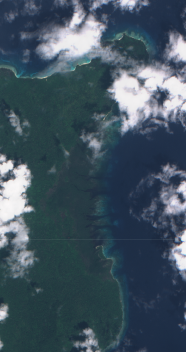
And this is today, 8 Jan
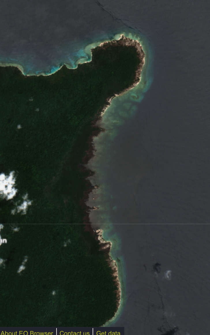
See the difference. Anak did some real damage. We were very lucky that the main wave was directed to the south, not the populated coasts.
The are very missed indeed
Volcanodaredevils
Sudden Stratospheric Warming.
Met Office just did a live youtube presentation on the Stratospheric Warming. Now available for replay.
https://www.youtube.com/watch?v=-3dyOjjRBts
Spot what looks like a rare public glimpse at some output from Met Office GLOSEA5 in there (the horizontal chart with the title cropped off).
Interesting! Thanks a lot! 🙂
Eruption report from Manam. I’d like to add my voice to the people who miss the Kraffts. The documentary “The Volcano Watchers” was epic.
A powerful eruption started at Manam volcano, Papua New Guinea around 21:00 UTC on January 7, 2019. The Aviation Color Code was raised to Red. Volcanic ash dissipated by 06:15 UTC, January 8.
According to the Darwin VAAC, satellite imagery suggest volcanic ash cloud rose up to 16.7 km (55 000 feet) above sea level, the center reported 22:59 UTC. “Discrete volcanic ash to 16.7 km (55 000 feet) a.s.l. and 12.8 km (42 000 feet) a.s.l. expected to dissipate within 6 to 12 hours. Continuous VA to 9.1 km (30 000 feet) is extending east. Height and forecast based on Himawari-8, IR temps, HYSPLIT and model guidance.”
Volcanic ash is difficult to discern due to a meteorological cloud, the center reported 03:59 UTC, January 8. However, the eruption is thought to be on-going to 9.1 km (30 000 feet) a.s.l., extending northeast. Volcanic ash to 16.7 km (55 000 feet) and 12.8 km (42 000 feet) has now dissipated.
Satellite imagery at 06:15 UTC indicated volcanic ash has dissipated. While hotspot remains visible, volcanic ash advisory was terminated.
This was the highest plume produced by the volcano since 2015 when VA rose to 19.8 km (65 000 feet) a.s.l.
The earthquakes near the Mauna Loa summit are becoming stronger again. The one just now was the strongest at the summit over the last month instead. And they are shallow.
And a funny thing: the earthquakes over the past year trace the northern caldera rim, and avoid caldera itself and the southern rim.
If I remember correctly, the inflation up until a year ago was centred around the pit crater on the southwest caldera rim.
If this keeps going for a while then sit back and watch the show, significant quakes are the one thing that didn’t happen at other times an eruption was predicted, now they are happening, and every time the show gets set back a year it gets bigger…
While the next eruption it has likely won’t be this, mauna loa is pretty much set to have a 100% guaranteed big eruption in the future, half a km3 of magma has to erupt sometime…
That was supposed to be a reply to UK Met Office thread but ended up here somehow.
Screenshot from Met Office video update today.
New post is up: https://www.volcanocafe.org/unrest-at-laacher-see-is-it-us-or-the-volcano/
Krakatau, whichever spelling is preferred, is dangerous simply due to its position on the convergence of the tectonic plates . It is a small and very unstable and a very collapsible island as proven over thousands of years. The power and volumetric force in its large magma chamber, and its ability to collapse and form deadly tsunamis is the major threat from Krakatoa. The volcanic island has collapsed into the ocean numerous times. The magma chamber is the size from the collapse of the 4 volcanoes of 1883 island to the 2018 collapse and in my opinion is much larger than the areas described by possibly many kilometers in with. The 1883 caldera is estimated to be more than 5 miles wide. Then into the equation comes the explosive power from the added seawater which has flooded into every Krakatoa explosion. Krakatoa will explode ferociously and rebuild and explode forever. This is one very deadly volcano and always will be. As you can see, I prefer Krakatoa, but the local pronounce it as Krakatau.